Task Force on NCEES Model Law Report of the Joint Task Force on NCEES Model Law for Surveying NCEES...
45
Report of the Joint Report of the Joint Task Force on NCEES Task Force on NCEES Model Law Model Law for Surveying for Surveying NCEES Annual Meeting Workshop Little Rock, Arkansas August 4, 2001 Jim Plasker Task Force Facilitator Report and Slides: www.asprs.org
-
Upload
darleen-norman -
Category
Documents
-
view
222 -
download
3
Transcript of Task Force on NCEES Model Law Report of the Joint Task Force on NCEES Model Law for Surveying NCEES...

Report of the Joint Task Force Report of the Joint Task Force on NCEES Model Lawon NCEES Model Law
for Surveyingfor Surveying
NCEES Annual Meeting Workshop
Little Rock, Arkansas
August 4, 2001
Jim PlaskerTask Force Facilitator
Report and Slides: www.asprs.org

Task Force on NCEES Model Law
Task Force HistoryTask Force History
1995 - NCEES Modifies Model Law to Include Photogrammetry and GIS/LIS
1996 - Concerns Raised/Letters Written by ASPRS, MAPPS, ASCE. Discussion at Winter NCEES/POLC Meeting
1997 - Five Organization Summit Meeting (ACSM, NSPS, MAPPS, ASPRS, ASCE). Agree to Work Together.
1997 - Task Force Addresses Photogrammetric Issues
1997/1998 - Task Force Report Delivered to NCEES (Covering non-GIS Issues Only)

Task Force on NCEES Model Law
Task Force HistoryTask Force History
1998 - NCEES Modifies Model Law to Include Savings Clause (Grandfather Language) per Task Force Recommendation
1999 - NCEES Modifies Model Law to Address Issues Related to Reciprocity/Comity and Ease of Mobility
1999 - Three GIS Organizations Invited to Participate in Extension of Task Force to Address GIS/LIS Issues(URISA, NSGIC, UCGIS)
2000 - NCEES Modifies Policies Related to Broadening Examination Coverage

Task Force on NCEES Model Law
Task Force HistoryTask Force History
2000 - Task Force Addendum to 1997 Report (covering GIS/LIS Issues) Delivered to NCEES
2001 - NCEES Task Force on Model Law Appointed
2001 – Registration Boards Forum, Las Vegas
2001 – Workshop at NCEES Annual Meeting, Little Rock

Task Force on NCEES Model Law
Task Force OrganizationsTask Force Organizations
American Congress on Surveying and Mapping (ACSM)
American Society of Civil Engineers - Geomatics Division (ASCE)
American Society for Photogrammetry and Remote Sensing
(ASPRS)
Management Association for Private Photogrammetric Surveyors
(MAPPS)
National Society of Professional Surveyors (NSPS)
National States Geographic Information Council (NSGIC)
Urban and Regional Information Systems Association (URISA)

Task Force on NCEES Model Law
Current Task Force RepresentativesCurrent Task Force Representatives
ACSMJohn Dailey, PLSDavid W. Gibson, PSM
ASCERobert C. Burtch, PS, CPSteven D. Johnson, PLS
ASPRSKaren Schuckman, LS, CPDoug Fuller, CP, CMS
URISABruce Joffe, AICP
MAPPSGeorge Gross, PE
G. Michael Ritchie, PLS, PE, CP
NSPSLee Hennes, PLS M. Greg Johnson, PLS, PE
NSGICLynda WayneGene Trobia
FacilitatorJames Plasker, PE
Task Force on NCEES Model Law
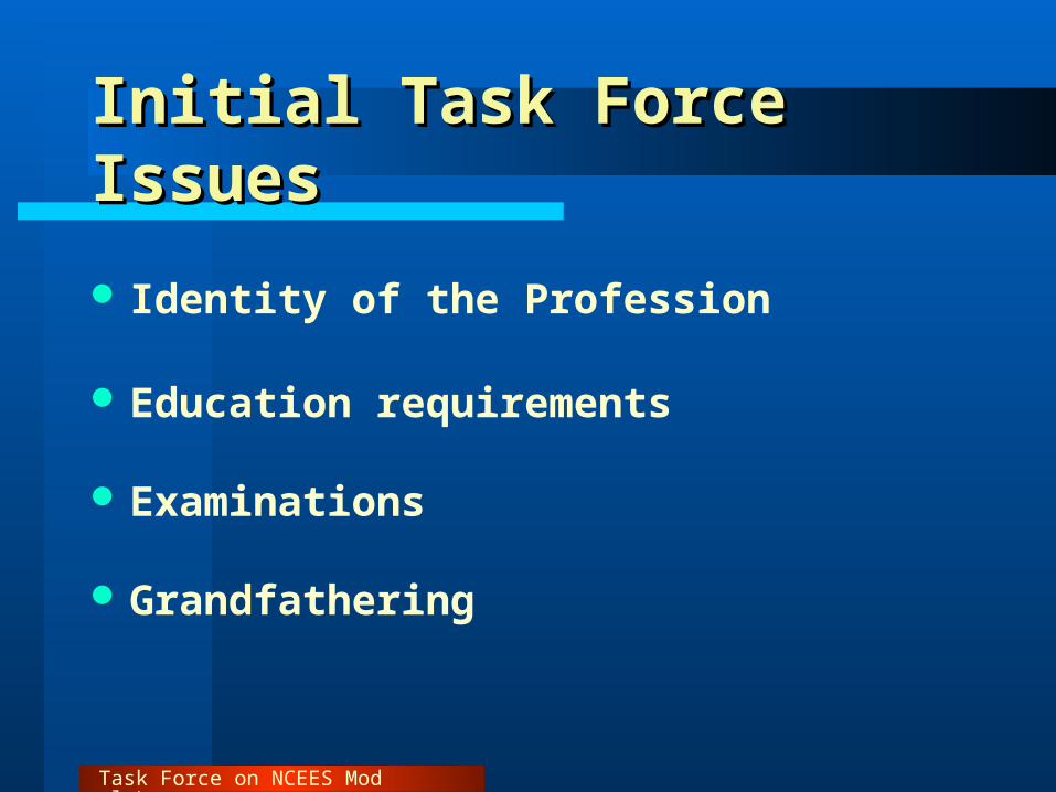
Initial Task Force IssuesInitial Task Force Issues
Identity of the Profession
Education requirements
Examinations
Grandfathering

Task Force on NCEES Model Law
Initial Task Force Issues Initial Task Force Issues (cont.)(cont.)
Reciprocity/Comity/Ease of Mobility
Exclusion of Practice
Continuing Education/Professional Development

Task Force on NCEES Model Law
Additional Task Force (GIS) IssuesAdditional Task Force (GIS) Issues
Breadth of Preamble Paragraph
Licensing: Practice v. Use of Tools
Regulatory Interest: High v. Low
Task Force on NCEES Model Law
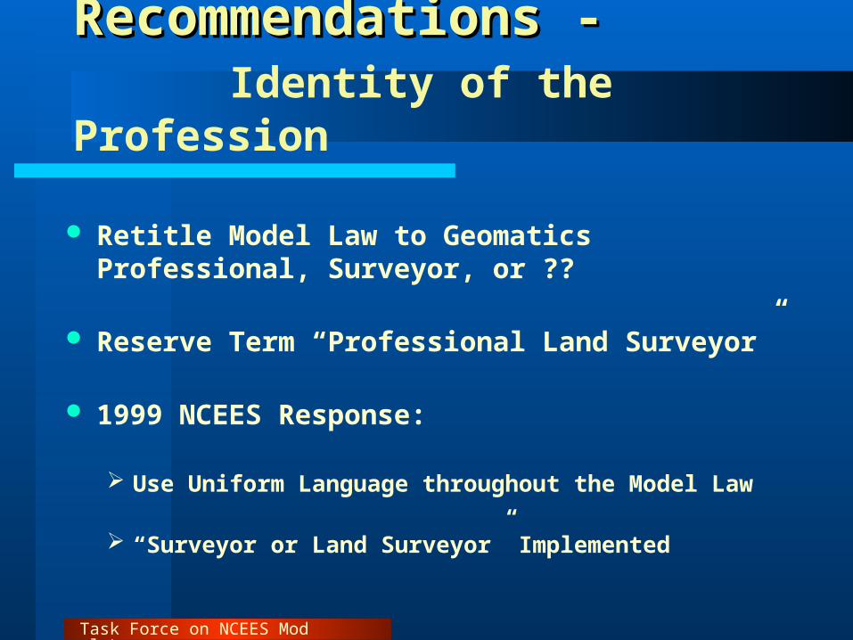
Recommendations -Recommendations - Identity of the Profession
Retitle Model Law to Geomatics Professional, Surveyor, or ??
Reserve Term “Professional Land Surveyor”
1999 NCEES Response:
Use Uniform Language throughout the Model Law
“Surveyor or Land Surveyor” Implemented

Task Force on NCEES Model Law
Recommendations -Recommendations - Education Requirements
Four Year Degree
ABET Accredited Program Preferred

Task Force on NCEES Model Law
Recommendations -Recommendations - Examinations
NCEES Exam Inclusive of All Covered Disciplines
Three part examination
– 1. Fundamentals of Measurement Science
– 2. Principles and Practice - Discipline-based
– 3. Legal and Boundary Practice - Jurisdiction-specific

Task Force on NCEES Model Law
Recommendations -Recommendations - Examinations (cont.)
Part 2 Exam Provide Choice of Disciplines
1. Representative of All Practice Areas
2. Reflective of Mobility Goals
3. Provide Similarly Experienced Individuals an Equal Opportunity for Success

Task Force on NCEES Model Law
Recommendations -Recommendations - Examinations (cont.)
Part 3 - Additional Exam Jurisdiction Specific
NCEES Utilize ASPRS Exam Resources for Part 2 and (in Interim) Possibly Part 3
ASPRS Resources Have Begun to Be Used

Task Force on NCEES Model Law
Recommendations -Recommendations - Grandfathering
Adopt Uniform Guidelines
1998 NCEES Response:
Savings Clause Adopted

Task Force on NCEES Model Law
Recommendations -Recommendations - Reciprocity/Comity
Recognize Generic Professional Practice Areas– Topographic Surveys– Geodetic Surveys– Construction/Engineering Surveys– GIS-Related Surveys– Etc.
Simplify mobility
Responsive to NAFTA Goals
NCEES Response in 1999 Sections (a) – (h) Incorporated in Definition of Surveying

Task Force on NCEES Model Law
Recommendations -Recommendations - Exclusion of Practice
Promulgate Guidelines
Recognize Areas of Low Regulatory Interest

Task Force on NCEES Model Law
Regulatory Interest LevelsRegulatory Interest Levels
High Interest Low Interest
ThemeDisplayed
Regulated resourcesaffecting property rights,property development,value of land, andboundaries.
Items of a resourcemanagement or inventorynature done for develop-ment of managementprograms/plans.
Base Data orTheme
Base layers such asparcels, roads, watercourses, contours,geodetic grids, geodeticcontrol, structures.
Theme data such asbotany, soils, otherresources, habitats thatare adjusted to baselayers.

Task Force on NCEES Model Law
Regulatory Interest Levels Regulatory Interest Levels (cont.)(cont.)
High Interest Low Interest
Use ofabsolutecoordinates
Publishing in state plane,latitude and longitude, UTMor other officially approvedcoordinate systems.
No published coordinatesor coordinate grids, or useof an assumed coordinatedatum.
PrimaryMeasure-ment vs.SecondaryMapping
Original view/original meas-urement (by conventionalground survey, aerial photo-grammetry, image mapping(the mapping part of remotesensing), or positioningsystems such as the GlobalPositioning System).
Mapping from archivalsources, data conversion,simple cartographic andimage manipulation.

Task Force on NCEES Model Law
Regulatory Interest Levels Regulatory Interest Levels (cont.)(cont.)
High Interest Low Interest
RelativeExpertise ofProducer vs.Receiver ofSpatial Data
Innocent funder orpurchaser of spatial datafrom a person/firmholding themselves out ashaving surveying/mappingexpertise.
Measurement andmapping within an agencyor firm for in-housepurposes where users arethe measurers.
Availabilityof Product orOutcome
Public Domain, innocentusers exist.
Private use, no directsecondary (innocent) user.

Task Force on NCEES Model Law
Recommendations -Recommendations - Continuing Education
Standardize Criteria
Streamline Recording of Credits
– CEU’s
– PDH’s

Task Force on NCEES Model Law
1999 NCEES Model Law1999 NCEES Model Law
Generic Surveying Clauses (a – d)
(a) Determining the configuration or contour of the earth’s surface or the position of fixed objects thereon by measuring lines and angles and applying the principles of mathematics or photogrammetry.
(b) Performing geodetic surveying which includes surveying for determination of the size and shape of the earth utilizing angular and linear measurements through spatially oriented spherical geometry.

Task Force on NCEES Model Law
1999 NCEES Model Law1999 NCEES Model Law
Generic Surveying Clauses (a – d)
(c) Determining, by the use of principles of surveying, the position for any survey control (non-boundary) monument or reference point; or setting, resetting, or replacing any such monument or reference point.
(d) Creating, preparing, or modifying electronic or computerized data, including land information systems, and geographic information systems, relative to the performance of the activities in the above described items (a) through (c).

Task Force on NCEES Model Law
1999 NCEES Model Law1999 NCEES Model Law
Boundary Surveying Clauses (e – h)
(e) Locating, relocating, establishing, reestablishing, laying out, or retracing any property line or boundary of any tract of land or any road, right of way, easement, alignment, or elevation of any of the fixed works embraced within the practice of engineering.
(f) Making any survey for the subdivision of any tract of land.

Task Force on NCEES Model Law
1999 NCEES Model Law1999 NCEES Model Law
Boundary Surveying Clauses (e – h)
(g) Determining, by the use of principles of land surveying, the position for any survey monument or reference point; or setting, resetting, or replacing any such monument or reference point.
(h) Creating, preparing, or modifying electronic or computerized data, including land information systems, and geographic information systems, relative to the performance of the activities in the above described items (e) through (g).
Task Force on NCEES Model Law
1999 NCEES Model Law1999 NCEES Model Law
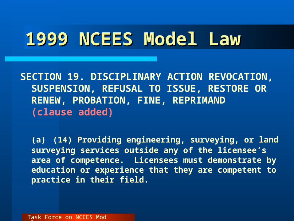
SECTION 19. DISCIPLINARY ACTION REVOCATION, SUSPENSION, REFUSAL TO ISSUE, RESTORE OR RENEW, PROBATION, FINE, REPRIMAND(clause added) (a) (14) Providing engineering, surveying, or land surveying services outside any of the licensee’s area of competence. Licensees must demonstrate by education or experience that they are competent to practice in their field.

Task Force on NCEES Model Law
Additional Task Force (GIS) IssuesAdditional Task Force (GIS) Issues
Breadth of Preamble Paragraph
Licensing: Practice v. Use of Tools
Regulatory Interest: High v. Low

Task Force on NCEES Model Law
NCEES Model Law:NCEES Model Law: GIS Community Concern - GIS Community Concern - Preamble ParagraphPreamble Paragraph
Practice of Surveying or Land Surveying - The term “Practice of Surveying or Land Surveying,” within the intent of this Act shall mean providing professional services such as consultation, investigation, testimony evaluation, expert technical testimony, planning, mapping, assembling, and interpreting reliable scientific measurements and information relative to the location, size, shape, or physical features of the earth, improvements on the earth, the space above the earth, or any part of the earth, and utilization and development of these facts and interpretation into an orderly survey map, plan, report, description, or project. The practice of surveying or land surveying includes, but is not limited to, any one or more of the following:

Task Force on NCEES Model Law
NCEES Model Law:NCEES Model Law: Task Force RecommendationTask Force Recommendation
Practice of Surveying or Land Surveying - The term “Practice of Surveying or Land Surveying” within the intent of this Act shall mean providing, or offering to provide, professional services involving both (1) the making of geometric measurements of, and gathering related information pertaining to, the physical or legal features of: the earth, improvements on the earth, the space above the earth, or any part of the earth; and (2) utilization and/or development of these facts into survey products such as graphics, digital data, maps, plans, reports, descriptions, and/or projects. Professional services include acts of consultation, investigation, testimony evaluation, expert technical testimony, planning, mapping, assembling, and interpreting gathered measurements and information related to any one or more of the following:

Task Force on NCEES Model Law
NCEES Model Law:NCEES Model Law: GIS Community Concern - GIS Community Concern - Practice vs ToolsPractice vs Tools
(d) Creating, preparing, or modifying electronic or computerized data, including land information systems, and geographic information systems, relative to the performance of the activities in the above described
items (a) through (c).

Task Force on NCEES Model Law
NCEES Model Law:NCEES Model Law: Task Force Recommendation Task Force Recommendation
(d) Creating, preparing, or modifying electronic or computerized data relative to the performance of the activities in the above described items (a) through (c).
(h) [Same language as above]

Task Force on NCEES Model Law
Regulatory Interest Regulatory Interest
Task Force Recommendation - InclusionsTask Force Recommendation - Inclusions
1. Maps and geo-referenced databases representing authoritative locations for boundaries, the location of fixed works, or topography by either terrestrial surveying methods, photogrammetric or GPS locations. Includes maps and geo-referenced data….provided to the public as a survey product

Task Force on NCEES Model Law
Regulatory Interest Regulatory Interest
Task Force Recommendation - InclusionsTask Force Recommendation - Inclusions
2. Original data acquisition or resolution of conflicts between multiple data sources, when used for the authoritative location of features … geodetic control, orthoimagery, elevation and bathymetry, fixed works, government boundaries and cadastral information
3. Certification of positional accuracy of maps or measured survey data

Task Force on NCEES Model Law
Regulatory Interest Regulatory Interest
Task Force Recommendation - InclusionsTask Force Recommendation - Inclusions
4. Measurement, adjustment, and authoritative interpretation of raw survey data
5. GIS-based parcel or cadastral mapping used for authoritative boundary definition purposes wherein land title or development rights for individual parcels are, or may be, affected

Task Force on NCEES Model Law
Regulatory Interest Regulatory Interest
Task Force Recommendation - InclusionsTask Force Recommendation - Inclusions
6. Interpretation of maps, deeds, or other land title documents to resolve conflicting data elements within cadastral documents of record
7. Acquisition of field data required to authoritatively position fixed works or cadastral data to geodetic control

Task Force on NCEES Model Law
Regulatory Interest Regulatory Interest
Task Force Recommendation - InclusionsTask Force Recommendation - Inclusions
8. Adjustment or transformation of cadastral data to improve the positional accuracy of the parcel layer(s) with respect to the geodetic control layer within a GIS for purposes of affirming positional accuracy

Task Force on NCEES Model Law
Regulatory Interest Regulatory Interest
Task Force Recommendation - Exclusions Task Force Recommendation - Exclusions
1. Creation of general maps: Road, water, air and pedestrian navigation maps and charts
Gazetteer or atlas as an educational tool or reference
publication
Prepared…for use in the curriculum of any course of study
Produced by [media] as an illustrative guide to the…location
of any event
Prepared by lay persons for conversational or illustrative
purposes [including] advertising material and users guides

Task Force on NCEES Model Law
Regulatory Interest Regulatory Interest
Task Force Recommendation - ExclusionsTask Force Recommendation - Exclusions
2. The transcription of previously geo-referenced data into a GIS or LIS by manual or electronic means, and the maintenance thereof, provided the data are clearly not intended to indicate the authoritative location of property boundaries, the precise definition of the shape or contour of the earth, and/or the precise location of fixed works of humans.
Task Force on NCEES Model Law
Regulatory Interest Regulatory Interest
Task Force Recommendation - ExclusionsTask Force Recommendation - Exclusions
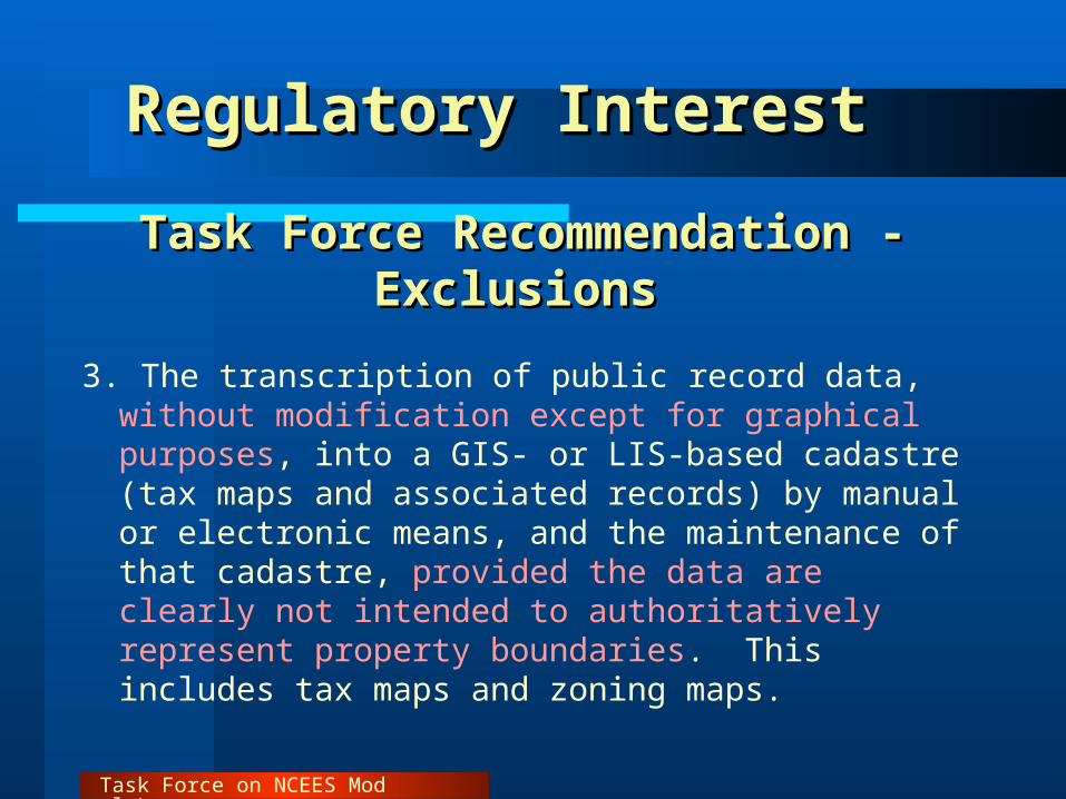
3. The transcription of public record data, without modification except for graphical purposes, into a GIS- or LIS-based cadastre (tax maps and associated records) by manual or electronic means, and the maintenance of that cadastre, provided the data are clearly not intended to authoritatively represent property boundaries. This includes tax maps and zoning maps.

Task Force on NCEES Model Law
Regulatory Interest Regulatory Interest
Task Force Recommendation - ExclusionsTask Force Recommendation - Exclusions
4. The preparation of any document by any Federal Government agency that does not define real property boundaries. This includes civilian and military versions of quadrangle topographic maps, military maps, satellite imagery, and other such documents

Task Force on NCEES Model Law
Regulatory Interest Regulatory Interest
Task Force Recommendation - ExclusionsTask Force Recommendation - Exclusions
5. The incorporation or use of documents or databases prepared by any Federal agency into a GIS/LIS, including but not limited to, federal census and demographic data, quadrangle topographic maps and military maps

Task Force on NCEES Model Law
Regulatory Interest Regulatory Interest
Task Force Recommendation - ExclusionsTask Force Recommendation - Exclusions
6. Inventory maps and databases created by any organization...of physical features, facilities or infrastructure that are wholly contained within properties to which they have rights or for which they have management responsibility. The distribution of these maps and/or data bases outside the organization must contain appropriate metadata describing, at a minimum, the accuracy, method of compilation, data source(s) and date(s), and disclaimers of use clearly indicating that the data are not intended to be used as a survey product

Task Force on NCEES Model Law
Regulatory Interest Regulatory Interest
Task Force Recommendation - ExclusionsTask Force Recommendation - Exclusions
7. Maps and data bases depicting the distribution of natural resources prepared by foresters, geologists, soil scientists, geophysicists, biologists, archeologists, historians, or other persons qualified to document such data
8. Maps and geo-referenced databases depicting physical features and events prepared by any government agency where the access to that data is restricted by statute. This includes geo-referenced data generated by law enforcement agencies involving crime statistics and criminal activities

Task Force on NCEES Model Law
Final ThoughtsFinal Thoughts
Task Force sought comment and input throughout the process, including public presentations, articles and web postings of materials
Recommendations of the Task Force have been developed through a consensus process
Email comments to:
[email protected]@asprs.org
All comments will be shared with the Task Force

Report of the Task Force on Report of the Task Force on NCEES Model Law for NCEES Model Law for
SurveyingSurveying
Report and Slides: www.asprs.org
(Follow External Affairs link)