TAKING STOCK IN THE LATE BRONZE AGE TO EARLY … (82) 39-78 Beamish... · in colour from...
40
TAKING STOCK IN THE LATE BRONZE AGE TO EARLY IRON AGE TRANSITION: A CROWDING- ALLEY AND SETTLEMENT SITE AT HAMILTON, LEICESTER Matthew Beamish and Martin Shore With contributions from: Jennifer Browning, Lynden Cooper, Nicholas J. Cooper, Robert Hogg, Angela Monckton, Graham C. Morgan Excavations at North Hamilton, Humberstone, have located a ditch system associated with a small settlement. The system is interpreted as a crowding- alley for livestock management and an indicator of large scale animal stock control in the earlier 1st millennium BC, possibly necessitating co-operation between different families or communities on a seasonal basis. Structural evidence includes at least one circular building that had seen some re-building. The pottery from the site was distinct from the more usual Iron Age assemblages in fabric and form, and flint was being used for tooling. INTRODUCTION The excavation was undertaken in advance of residential development within the Hamilton Northern Housing Area at Hamilton, Leicester (SK634074). The development site covers c. 55ha., 1.6 km north of Humberstone village and 5.6 km north-east of Leicester City Centre (Fig. 1) and consists of pasture and arable fields on north-facing slopes above the Melton Brook at a height of 65–95m O.D. The fields fell within the open fields of the medieval village and ridge and furrow was evident after machine stripping. The underlying geology is glacial boulder clay with areas of overlying sand and gravel which in turn overlay Mercia mudstone. The site is situated on a small spur of land between 80m and 75m OD, above a steepening slope to the north down to the valley bottom and the lesser slopes of dry gullies to the immediate west and east. The gully to the east was topped by a major field boundary running north-south dividing the edge of the present City of Leicester from the parish of Beeby; this boundary was also the limit of the development area (Fig. 2). Trans. Leicestershire Archaeol. and Hist. Soc., 82 (2008)
Transcript of TAKING STOCK IN THE LATE BRONZE AGE TO EARLY … (82) 39-78 Beamish... · in colour from...

TAKING STOCK IN THE LATEBRONZE AGE TO EARLY IRON
AGE TRANSITION: A CROWDING-ALLEY AND SETTLEMENT SITE AT
HAMILTON, LEICESTERMatthew Beamish and Martin Shore
With contributions from:Jennifer Browning, Lynden Cooper, Nicholas J. Cooper, Robert Hogg,
Angela Monckton, Graham C. Morgan
Excavations at North Hamilton, Humberstone, have located a ditch systemassociated with a small settlement. The system is interpreted as a crowding-alley for livestock management and an indicator of large scale animal stockcontrol in the earlier 1st millennium BC, possibly necessitating co-operationbetween different families or communities on a seasonal basis. Structuralevidence includes at least one circular building that had seen some re-building.The pottery from the site was distinct from the more usual Iron Ageassemblages in fabric and form, and flint was being used for tooling.
INTRODUCTION
The excavation was undertaken in advance of residential development within theHamilton Northern Housing Area at Hamilton, Leicester (SK634074).
The development site covers c. 55ha., 1.6 km north of Humberstone villageand 5.6 km north-east of Leicester City Centre (Fig. 1) and consists of pasture andarable fields on north-facing slopes above the Melton Brook at a height of 65–95mO.D. The fields fell within the open fields of the medieval village and ridge andfurrow was evident after machine stripping. The underlying geology is glacialboulder clay with areas of overlying sand and gravel which in turn overlay Merciamudstone.
The site is situated on a small spur of land between 80m and 75m OD, above asteepening slope to the north down to the valley bottom and the lesser slopes ofdry gullies to the immediate west and east. The gully to the east was topped by amajor field boundary running north-south dividing the edge of the present City ofLeicester from the parish of Beeby; this boundary was also the limit of thedevelopment area (Fig. 2).
Trans. Leicestershire Archaeol. and Hist. Soc., 82 (2008)

40 MATTHEW BEAMISH AND MARTIN SHORE
Fig. 1. Location plan showing Hamilton in relation to other sites mentioned in the text.

TAKING STOCK IN THE LATE BRONZE AGE TO EARLY IRON AGE TRANSITION 41
BACKGROUND
Archaeological evaluation comprising field walking surveys, geophysical surveyand trial trenching (Leicestershire Museums Arts and Records ServiceArchaeological Survey Team Report 94/3; Leicestershire Archaeological UnitReport 94/41; ULAS Reports 2000/32; 2000/40; 2000/67) had identifiedarchaeological potential in three main and three ancillary areas. A recordingprogramme following a brief from the Leicester City Council planningArchaeologist resulted in two separate area excavations, (Fig. 16, A and B;Beamish 2003, 131). Site A, was recorded in two adjacent areas betweenDecember 2000 – January 2001 (Area 1) and May – June 2002 (Area 2).
The contexts are divided into cut numbers in square brackets (e.g. [6]) and fillsin round brackets (e.g., (91)). It has not been possible for a definitive phasingsequence to be deduced and the features are described in functional groups.
The finds and records have been deposited with Leicester City Museum Serviceunder Accession Nos. A.6.2000 and A14.2002.
The general arrangement of the site comprised two ditch systems with anumber of structural areas to the north and south (structures 1–8) with smallnumbers of discrete pits within and between these. All the structures appear to beLate Bronze Age/Early Iron Age in date and some degree of contemporaneity,while the two ditch systems are separated by perhaps 800 years.
IRON AGE DEPOSITS
The ditch system (Fig. 3)
DITCHES A, A1, A2 AND A3; DITCH B; DITCH C AND C1; DITCHES D AND
D1; DITCH E AND E1; PIT 187A series of shallow ditches were traced for 93m from east-south-east to west-north-west before turning to the south-west for a further 27m. The ditchesfollowed the contour of the land at a softening in the northerly slope at 77m OD,and were in two broadly parallel groups north and south, so defining an area120m long, ranging from 2.7m to 9m in width. Some recutting was apparentalthough where they were identified this was sometimes discontinuous andconfused by the medieval furrows. The ditch-fills showed little variation rangingin colour from mid-greyish browns to mid-orange greyish browns and allconsisted of silty sandy clays. In profile the ditches had sides sloping at between30° and 45° with curved bases and depths typically between 0.30 and 0.50m. Thegeneral lack of differentiation between the profiles and fills of the various cuts andrecuts made the resolution of what relationships existed difficult.
DITCHES A,A1,A2,A3A minimum of four stratigraphic sub-phases were identified in the northern group(A, A1, A2 and A3). The earliest of these was found in the west of the mainexcavation area where a single ditch on the northern side of the system continued

on a straight west-north-west alignment toward Structure 3. This ditch wastruncated at its eastern end by a pit and at its western end by a later ditch cut (A1),which seems to have shared a similar line to its own successor (A2) although, asditches A1, A2 and A3 were not recorded as continuous features, this cannot beestablished with certainty. Ditch A3 curved strongly to the south in the westbefore terminating. The latest sub-phase recorded at the eastern end (represented
42 MATTHEW BEAMISH AND MARTIN SHORE
Fig. 2. All features, with contours and medieval ridge and furrow.

TAKING STOCK IN THE LATE BRONZE AGE TO EARLY IRON AGE TRANSITION 43
here also as ditch A3) showed a ditch terminating a metre short of a right-angledturn that appeared, previously, to continue between ditches A/A1 and E. Twenty-five metres south-east of Structure 3, a sub-square pit [187], cut one phase of ditch(A2) and was itself cut by the final phase ditch (A3). This pit contained potterysherds of a round shouldered vessel in a fine grog-tempered fabric (Fig. 10, 1).
DITCH BDitch B on the northern side of the southern group was recorded as a continuousfeature which showed no evidence of recutting and shared a common alignmentwith A3. Ditch B terminated in a similar way to A3 to the west. The terminalformed by ditches A3 and B was flared. To the immediate east of this terminal thearea between the ditches narrowed to form a slight bottle neck. At its eastern endditch B petered out and, although this may have been a terminal point, it is alsopossible that this area on the line of the later borough city boundary had beenmore aggressively truncated.
DITCHES C, C1Ditch C lay a metre or so to the south of ditch B, and was again cut along a similarline although at its western end, it diverged from ditch B and the distance betweenthe two features was widened to over 3m. A second ditch (C1) ran closely parallelwith C. As these ditches did not intersect it is possible that they werecontemporary, although as the area was heavily plough-truncated, and the ditcheswere perhaps 1m deep when first cut, the two ditches would have effectivelyshared a common edge at ground level and any such contemporaneity is doubtful.
After a break of some 5m, the line of ditch C was re-established by anotherditch, D, which also had been partly re-cut (D1). D/D1, which did intersect at adistinct kink and maintained a similar line to B albeit terminating 13.50m shortand at the same time diverging so that the distance between the ditches was againwidened.
DITCHES E, E1In the east, the first phase northern ditch represented (A and/or recut A1) turnedsharply to the north and was traced running down the gentle valley slope (E), witha broadly parallel neighbour between 0.30 and 1.50m to the east (E1), for afurther 26m before continuing beyond the excavation area. E1 turned to the eastin the south. Both ditches had similar fills; although they did not intersect and mayhave been contemporary, the space between the two ditches became increasinglynarrow in the south, and it seems likely that they must have intercut prior toplough truncation.
A distinct sub-square depression, 1.1m by 1.35m, and 0.22m deep wasrecorded in the base of an excavated segment through ditch E, 3.6m north of itsjunction with ditch A/A1. Filled with a mid orange brown silty sandy clay, thiswas probably the base of a pit pre-dating the ditch, but as any relationship wasinadvertently removed in its entirety during the excavation of the ditch, this mustremain uncertain.

Within a 2.5m long segment excavated through the same ditch immediatelynorth of its intersection with Ditch F, no pitting existed.
SURFACING
Four extremely light spreads of small to medium rounded pebbles were recordedon the southern side of the system and at the eastern junction. Recognition of thelayers was only made after the site had been open for several weeks due to thediffuseness of the spreads and no clear stratigraphic relationship with the ditcheswas established. Three of the spreads overlay the infilled ditches although the linesof the ditches themselves remained clear; the likelihood is that the metalling post-dated at least the earlier fills of the ditches, although there remains a possibilitythat plough action had dragged stones back over the infill and distorted thesurface stratigraphy.
Structures
Evidence of three circular or part circular structures was recorded. All three exampleswere partially indicated by lengths of curvilinear gullies on their southern edges.
STRUCTURE 1 AND NEIGHBOURING FEATURES
The first and clearest represented example was centred some 12m north of thegully system within Area 2 and measured 13.50 metres in diameter. The southernside of the structure was formed by a 21m length of shallow gully (albeit with aportion clearly removed by furrowing) which although defining what was mostprobably a circular area had not been cut with any particular curve. Someevidence of recutting was observed in the south and south-east, with the limitedevidence suggesting that an initial shallow slot, was replaced by a slot with postholes along its length. Further fragmentary lengths of poorly aligned slot and postsettings of very variable size were found on the northern side.
ENTRANCE
An entrance to the building was formed by two substantial elongated post pits[109] and [161], measuring 1.80m between their centres. Both of these featureswere filled predominantly with mid orangey brown to grey silty clays containingsome charcoal and fire cracked stone. Both had evidence of (probably disturbed)post packing, comprising fragments of sandstone ranging from 0.15m to 0.30m insize, and both had more sloping edges on the southern sides. Oak charcoal from[109] was dated to 760–410 cal BC (Wk15080;2463 ± 38 BP).
To the east of the northern entrance post pit [109] was a line of four pits ofvariable dimensions, three of which contained fragments of calcined anduncalcined bone. The most substantial was [93], a vertically sided flat based cutfilled by orangey brown silty clay which contained probably displaced stonepacking material. Post pit [93] was potentially mirrored on the south side of theentrance by [97], a much slighter feature although with a similar fill. The two postholes measured 3.60m between centres and were aligned 5o south of east.
44 MATTHEW BEAMISH AND MARTIN SHORE

TAKING STOCK IN THE LATE BRONZE AGE TO EARLY IRON AGE TRANSITION 45
Fig.
3.T
hedi
tch
syst
em.

At the west end of the internal area was a line of four probable post holesrunning north-south, two of which were half-sectioned.
INTERNAL FEATURES
Within the structure a wide but shallow pit [173] was centrally located, filled by alower brownish black silty clay (172) with charcoal which also filled a post socketlike depression in the base of the pit on the east side, and an upper fill of moremixed silty clay. A radiocarbon date of 800–500 cal BC (Wk-15081;2510 ± 38BP)was determined from oak charcoal from 172.
The pit was cut by two smaller features of a group of four of similardimensions, probably post holes, which formed a trapezoid configuration, 1m x1.4m, near the notional centre point of the building.
One metre to the north-west of the central features were a further two pits[112], and [115]. The latter contained two fills of silty clay, the lower of whichwas a dark grey brown (114) and contained charcoal, ash and lumps of burnt clayfrom which were recovered some 760 fragments of burnt cattle and sheep bone.The excavator perceived the lower fill to have been backfilled into the pit from oneside. Neither pit showed any indications of in situ burning.
Seven metres south east of Structure 1 was a solitary pit, [31] (Fig. 3) filledwith a dark brown silty clay with abundant burnt stone and undiagnostic charredmaterial (including an indeterminate cereal fragment).
Processed samples from pits [115] and [173] produced only single numbers ofcharred seeds including fat-hen and large grass with occasional cereal fragments.
STRUCTURE 2A second structure was situated immediately to the west of Structure 1; allthat remained was a 3.8m length of curvilinear gully (260) of 7m radius, andsome possible internal features, probably post holes, that were not excavated.The nature of the building remains unknown, due to the combination of laterplough truncation and the somewhat heterogeneous building style as reflected inStructure 1.
Projection of a circle indicates that a similarly sized round-house to thatsuspected for Structure 1 could have sat just to the north of the ditch system, andneed not necessarily be of a separate phase. An unexcavated portion of linearfeature just surviving disturbance by the later ditch F might have been acontinuation of this gully.
STRUCTURE 3 AND NEIGHBOURING FEATURES
A third structure was situated at the north-western corner of area 2, immediatelynorth of ditch A. Two concentric curvilinear gullies were recorded of 7m and 7.80mradii, both filled with orangey brown charcoal rich silty clays. The inner gully, [182]which at 10m long almost described a quadrant, was shallow and possiblystructural, as the base of the cut at the eastern terminal included two probable postsettings. The outer gulley, [180], was at least 0.30m deep and substantially deeperthan its neighbour, although conversely shorter at only 4.5m long.
46 MATTHEW BEAMISH AND MARTIN SHORE

TAKING STOCK IN THE LATE BRONZE AGE TO EARLY IRON AGE TRANSITION 47
Over 520 fragments of calcined bone were recovered from the excavatedterminal of [180], within which those from sheep, and sheep or goat wereidentifiable. Charred barley grains, a glume of emmer or spelt chaff and a seed oflarge grass were identified plant remains from the same context.
Two radiocarbon dates from the fill of [180], returned statistically equivalentdates, indicating that the material could be of the same age; these dates combinedto give a date of 750–680, 670–640, 600–400 cal BC (Wk15082; 2406BP±37 andWk15083 2471BP±38).
INTERNAL FEATURES
Internal features consisted of three probable post holes filled with mid orangeyellow brown silty sandy clays which formed a line. The northernmost post holewas located very close to the notional centre point of circles best fitted to thecurvilinear gullies.
Both gullies cut an earlier cluster of pits, one of which cut ditch A, indicatingthat the structure post-dated ditch A. The curvilinear gullies were both cut by alater ditch F (below).
Three metres south of Structure 3 was a steep sided, flat based pit, [156](157/8), 1.02m by 0.96m by 0.42m deep. The pit was filled by dark grey brownsilty sandy clay, above mid-orange brown silty sandy clay. Pottery was recovered
Fig. 4. Structure 1 from its eastern entrance.

from the top fill (157) which was also rich in charred material that included abarley grain and a seed of brome grass.
To the south-west of the structure, were three further post holes. Two of thesewere of similar size and fill, a greyish brown silty sandy clay, whilst a third to thesouth, comprised a dense surface deposit of large pebbles in a shallow cut, tightlywedged together with sharp ends embedded in the natural clay.
STRUCTURE 4, AND NEIGHBOURING FEATURES
Five probable post holes, all unexcavated, filled with dark greyish brown siltysandy clays partly enclosed an area 2.9m long, and 4.5m wide aligned northeast –southwest, situated at the far north western extent of Area 2.
48 MATTHEW BEAMISH AND MARTIN SHORE
Fig. 5 Structures 1 and 2.

TAKING STOCK IN THE LATE BRONZE AGE TO EARLY IRON AGE TRANSITION 49
Two further post holes to the south, measuring 1.20m between their centresand also unexcavated, potentially formed a two-post structure aligned to thesouth-east.
Seven metres south-west of Structure 4, was an ovoid pit [174]. The upper oftwo similar grey brown silty clay fills was of interest, as it contained quantities ofcharcoal, pottery and burnt bone, in particular just above the interface with thelower fill. The interface sloped evenly across the feature, and the deposits mayhave been back fills. A spelt glume, two hulled barley grains and a seed of bromegrass were identified samples. The pottery from [174] included relatively thickwalled grog tempered sherds.
STRUCTURE 5Twelve metres to the south-east of Structure 1 was a cluster of 12 small post holesand several pits. Five of the post holes formed a convincing line 4.8m long,running south-west to north-east from [57] and ending with [87]. Three furtherpost holes to the west of [87] suggest perhaps another side, but no other clearcorresponding wall lines were evident.
Fig. 6 Structures 3 and 4.

A post hole in the south-west cut ditch A/A1, but the absence (bar one) of postholes on the south side of the ditch system suggests that any structure essentiallylay to the north and perhaps was contemporary with a later ditch phase (e.g. A3).
Within and to the west of the vague rectangular area formed by the post holesand the ditch system were two pits. Pit [100] was filled with a mid orange brownsilty clay with quantities of fire-cracked stones, burnt clay lumps and charcoal.
One metre to the west of [100] was a slightly deeper pit, [50], filled with aorangey brown silty clay rich with ash and charcoal. Unidentifiable fragments ofburnt bone were recovered from both [50] and [100] and an indeterminate cerealgrain from the former.
STRUCTURES 6 AND 7Two possible (but incomplete) four post structures lay to the south of the ditchsystem. Structure 6 was 2.5m by 1.7m between centres; three possible corner postholes were recorded, the fourth perhaps truncated by a furrow. A further smallpost hole was found on the southern side. All post holes were filled with mid todark yellowish brown silty sandy clays.
Structure 7 was situated 4m north-west of structure 6, and similarly just southof the ditch system. Three unexcavated possible post holes filled with dark greyishbrown silty sandy clays were 2.60m and 2.40m apart. There is no indication whya fourth post hole was missing.
A possible two-post structure aligned east-north-east with post holes 1.37mapart between their centres lay 7m to the east of Structure 6.
STRUCTURE 8A small area of isolated features was recorded some 80m south of the ditchsystem. These comprised three gully segments, possibly describing an arc of some6.29m radius. Two clear phases of gully were apparent, with the outer being laterin date; the inner gullies were similar and are considered likely to have beencontemporary, although any continuity was obliterated by a plough furrow. Allthe features were filled with mid greyish brown silty sandy clays.
Eight metres north-west of the structure were two probable post holes, filledwith greyish brown silty sandy clays.
Romano-British (or later)
DITCH FA ditch, defining the south-western corner of a field or enclosure was recordedrunning south for 25m, from the northern edge of excavation, before turningsharply to the east for a further 100m, and also continuing beyond the excavation.The ditch which cut all other features encountered (but was itself cut by thefurrows) was up to 1.67m wide and 0.57m deep, and filled with mid-yellowbrown to dark grey yellow brown silty sandy clays. As relationships were mostlyclear in plan, only one segment of the ditch was excavated, at its junction with E,
50 MATTHEW BEAMISH AND MARTIN SHORE

TAKING STOCK IN THE LATE BRONZE AGE TO EARLY IRON AGE TRANSITION 51
from which one abraded sherd of Romano-British pottery and one residual IronAge rim sherd were recovered.
THE LITHICSLynden Cooper
The lithics were all of local till-derived flint bar the possible whetstone. There is aprobable Upper Palaeolithic component in the unstratified material from thenorth-western area of the site. While there are no diagnostic tools there aretechnological indications for such in the use of partial edge faceting of theplatform. This form of platform preparation did not occur in Mesolithic reductionstrategies.
The majority of the stratified material has typological and technologicalindications to be of a Late Bronze Age date. The tool forms are limited to scrapersand a piercer. The scraper forms include straight-edged and concave varieties,
Fig. 7. Structures 5, 6 and 7.

types that often occur in the Late Bronze Age. The reduction strategies were crudeshowing limited knapping skills. The flakes were produced with a hard hammerand displayed wide butts, squat and thick with no evidence for platform and corepreparation, features well documented for Late Bronze Age lithics (Ford et al.1984). The lack of knapping skills is exemplified by a core from Ditch B where theknapper made 14 deep and unsuccessful blows to the platform. The freshness ofthe material from the Structure 1 group suggests it was contemporaneous.
52 MATTHEW BEAMISH AND MARTIN SHORE
Fig. 8. Structure 8.
Fig. 9. Ditch F (Romano-British or later).

TAKING STOCK IN THE LATE BRONZE AGE TO EARLY IRON AGE TRANSITION 53
Group Cont Type Note
Structure 1 88 Flake Crude, fresh, incipient cones92 Core Crude and fresh4 x flakes Crude and freshBurnt shatterPossible whetstone94 2 x flake Fresh, thick96 Flake CrudeFlake98113 3 x flakes Fresh114 5 x flakes Squat, thick, no core front preparation152 Utilised flake Both thick and freshRetouched flake153
Structure 3 197 3 x flakes201 Flake
Structure 7 2007 FlakeDitch A 33 Flake
Retouched flakeDitch B 80 Core Crude and fresh
ShatterChip5 x flakes192 Core 14 incipient cones on platform2016 Flake
Ditch C 76 2 x flakes All squat and thickConcave scraperUtilised flake
Ditch E 13 2 x flakes105 FlakeRetouched flake169 1 shatterFlake Good core front preparation177 Piercer On thick supportCoreFlake Patinated
Ditch E 177 Core (on flake)3 x flakesBurnt shatter5 x shatter
Ditch F 166 1 flake Crude, thickPit 156 157 2 x flakesPit 174 175 2 x flakesPit 187 186
187 FlakePit 2002 2002 Flake CalcinedU/S Concave scraper Faceted butt
3 x cores Exhausted5 x flakesRetouched flake5 x bladelets Continued on next page

Group Cont Type Note
U/S NW Blade core Partial platform edge faceting(single platform)Blade core Partial platform edge faceting(opposed platform)Scraper Patinated(end of blade)Flake Blade scarsFlake frag.Flake frag. BurntFlake frag. Faceted buttChipCore Crude4 x flakes2 x flakes BurntThumbnail scraper Non-fancy, NB spurBladelet core Partial platform edge facetingBladeUtilised bladeScraper (Side) Straight retouch on reused blankConcave scraper
U/S=Unstratified Table 1. Lithics.
PREHISTORIC AND ROMAN POTTERYNicholas J. Cooper
Prehistoric Pottery
ASSEMBLAGE SUMMARY
An assemblage of 241 sherds of later prehistoric pottery weighing 0.990kg wasrecovered. The low average sherd weight of 4g, confirms the highly fragmentedand generally abraded visual appearance of the assemblage, with shell inclusionsinvariably being leached from the individual sherds. Very few rims are representedand, in terms of fabric, the assemblage is very variable with few examples adheringclosely to the established fabric series, developed mainly during the examinationof Middle and Late Iron Age material from the nearby sites at Wanlip andHumberstone (Marsden 1998; 2000). The possibility of a Late Bronze Age orEarly Iron Age date for the assemblage is, however, supported by a series ofradiocarbon dates indicating occupation between 8th and 5th centuries BC (belowp.64) . Two of these dates derive from contexts associated with Structures 1 (110)and 3 (181), both of which also contained pottery. Across the site pottery derivedfrom the ditch system, and Structures 1, 3, 5 and 7 with a proportion fromungrouped contexts (Table 2).
54 MATTHEW BEAMISH AND MARTIN SHORE

TAKING STOCK IN THE LATE BRONZE AGE TO EARLY IRON AGE TRANSITION 55
Group Sherds Weight
Ditches A-E 63 242Structure 1 63 254Structure 3 26 200Structure 5 8 7Structure 7 12 14Isolated Pits 69 273Total 241 990
Table 2. Pottery from the site.
METHODOLOGY
The Iron Age material has been analysed by form and fabric using theLeicestershire County Museums prehistoric pottery fabric series, with reference tothe Prehistoric Ceramic Research Groups Guidelines (PCRG 1992), andquantified by sherd count/weight.
ANALYSIS BY FABRIC AND FORM
Table 3 summarises the occurrence of individual fabrics across the assemblage.For convenience the currently published fabric descriptions for later prehistoricpottery from the county are summarised below for comparison.
Q1 SANDY WARE
Moderate to very common sub-rounded or rounded quartz (well to moderatelysorted, up to 1mm) and sparse-moderate angular quartz.
R1 (FORMERLY RQ1) IGNEOUS ROCK INCLUSIONS (GRANODIORITE)Sparse to very common sub-angular igneous rock fragments (poorly sorted, mostup to 5mm).
Fabric SummaryFabric % sherds Sherds Weight
S1 Shell 40 97 491S1 Fine shell 5 11 50S2 shell/sand <1 1 4R1 granite 2 4 32Q1/R1 sand/granite 8 19 58G grog 17 40 172G/Q1grog/sand 2 6 28G/S1grog/shell 4 9 28G/S2grog/sh/sand 22 54 127Total 100 241 990
Table 3. Prehistoric pottery fabrics.

S1 SHELL TEMPERED
Moderate to very common, well to poorly sorted fossil marine shell up to 8mm.Little or no sand content; soapy feel.
S2 FOSSIL SHELL-TEMPERED WITH SAND
Similar to S1, but with quartz sand.
G GROG-TEMPERED WARE
Rare-sparse sub-rounded grog (well–moderately sorted, 1–5mm), rare quartz sandand rare acid igneous rock fragments.
The fabrics here contrast markedly with those of the nearby sites of Middleand Later Iron Age date both in terms of the uniformity of inclusion type and thedominance of particular inclusion types. In addition there are no occurrences ofscored decoration. Assemblages of Middle and Later Iron Age sites in this part ofthe county would normally be dominated by the use of mineral inclusions such asquartz and granite (fabrics Q1, Q2 and R1) and use of shell is marginal (Marsden1998, 46, Table 4 and 2000, 172). By contrast, in this assemblage, 46% of thepottery employs shell as the dominant inclusion (fabrics S1 and S2) and it occursas a minor inclusion in a further 26%. Only about 10% employs only mineralinclusions and a further 17%, only grog. Significantly 22% contains acombination of grog, shell and sand (G/S2) including the three sherds fromcontexts used for radiocarbon dating discussed above. This mixed fabric occursacross the site in Ditch A/A1 (34 and 35), Ditch B (192, 2016), Ditch E (169), andin Structures 1, 3 and 7 and residually in Ditch F (166), which also produced anabraded Roman sherd.
It might be tentatively argued that all bar ditch F are broadly contemporarywith that Late Bronze Age/Early Iron Age dating. Two rims occur in thefabric, an upright or direct flat one residually from Ditch F (166) and anunfamiliar upright form with a T-shaped flattened lip from ditch E (169), whichalso occurs in a predominantly shell-tempered fabric (virtually indistinguishable),from the same context and is paralleled within the assemblage from Gretton,Northamptonshire (Jackson and Knight 1985, Fig. 6, 12). The only other rimis another flattened upright form from Structure 5 (57) in a shell-temperedfabric. Fabrics of purely mineral composition are largely confined to Structure 5but also occur in Structure 1 and some pit groups. Base and lower body sherdsin the grog-tempered fabric (Fig. 10, 2) came exclusively from Pit [174]between Structures 3 and 4 and may compare with an example of an ovoid jaralso from Gretton (Jackson and Knight, 1985, Fig. 6, 16) although similarsherds also containing shell came from Structure 1 (92) and a pit [187] cutby ditch A2. The latter example is from a thin-walled round shouldered bowlagain similar to examples from Gretton (Jackson and Knight, 1985, Fig. 7,42; Fig. 8, 64). Pit [174] produced the only sherd of granitic fabric R1 whichis commonly associated with scored ware in Middle and Late Iron Ageassemblages.
56 MATTHEW BEAMISH AND MARTIN SHORE

TAKING STOCK IN THE LATE BRONZE AGE TO EARLY IRON AGE TRANSITION 57
The substantial assemblage of Early Iron Age pottery from Gretton,Northamptonshire (Jackson and Knight, 1985, 75–82), with which elements ofthis assemblage clearly find parallel, was also dominated by shell and grog basedfabrics.
Discussion
Importantly, within the limits of current understanding in the county and withoutthe series of radiocarbon dates, this assemblage would be difficult to placechronologically. Indeed, prior to the radiocarbon dates becoming available, andhad it not been for the occurrence of unfamiliar T-shaped rim forms, thisassemblage would have been assumed to be very late pre-Roman Iron Age ortransitional mid first century AD in date, judging by the proportion of shell andgrog-tempered fabrics.
In contrast, grog temper did not feature in a recently excavated assemblage ofLate Bronze Age date from Rearsby (Marsden 2008, 56) in which fabrics werequartz and granodiorite based. A single radio-carbon date from a pit containingPost Deverel-Rimbury pottery calibrated to 1130BC-910BC (Wk-20444;2848±36) (Beamish and Clark 2008, 57).
ROMAN POTTERY
Only one stratified sherd was recovered, the abraded rim of an oxidised ware jar.An Iron Age vessel rim came from the same context.
A6 2000 and A14 2002 Hamilton North Roman Pot
Group Accession Context Cut Fabric Sherds Weight
Ditch F A14. 2002 166 168 OW 1 4Unstratified A6.2000 GW 1 16Total 2 20
Table. 4. Roman pottery.
Fig. 10. Prehistoric Pottery. Scale 1:4.1. Round shouldered bowl, Fabric G/S1, 187.
2. Ovoid jar, Fabric G, 175.

CHARRED PLANT REMAINSAngela Monckton
Introduction
Samples were taken from deposits with potential to contain charred plant remainsin order to recover evidence of crops and cultivation, and possibly giveinformation about activities on the sites. Prehistoric pits and gullies were sampledand it was hoped that the investigation of these samples would provide theopportunity to add to our knowledge of agriculture in the region.
Methods
Samples amounted to seven bulk samples from pits and gullies which were wetsieved in a York tank using a 0.5mm mesh with flotation into a 0.5mm mesh sieve.The residues were air dried and the fraction over 4mm sorted for all finds whichare included in the relevant sections of this report. The fraction below 4mm wasreserved for sorting during the analysis stage if required. The flotation fraction(flot) was air dried and packed carefully in self-seal polythene bags.
The flots were sorted at x10 magnification with a stereo-microscope. The plantremains were then identified by comparison with modern reference material,counted and recorded (Table 5). The plant names follow Stace (1991) and thecereals Zohary and Hopf (1993) and are seeds in the broad sense unless stated.
Results
THE PLANT REMAINS
Structure 1One post hole and an internal pit were sampled and produced only single numbersof charred seeds including fat-hen and large grass with occasional cerealfragments. A sample of charcoal was collected from a third post hole and wassubmitted for radiocarbon dating (below p.63).
Structure 3A sample from a gully segment produced two charred barley grains, a glume ofemmer or spelt chaff and a seed of large grass. Charcoal was submitted forradiocarbon dating (below p.63).
Pits 31, 50, 156 and 174Samples from each of these pits contained single numbers of remains. The samplesfrom pits 31 and 50 contained only an indeterminate cereal fragment each; pit 156contained a barley grain and a seed of brome grass; pit 174 contained a speltglume, two hulled barley grains and a seed of brome grass.
58 MATTHEW BEAMISH AND MARTIN SHORE

TAKING STOCK IN THE LATE BRONZE AGE TO EARLY IRON AGE TRANSITION 59
Discussion
The prehistoric features of Late Bronze to Early Iron Age date produced smallnumbers of charred cereal remains including spelt and barley with a few weedseeds. These show only food preparation and consumption of the cereals on thesite. Spelt has also been found in a Bronze Age context at Lockington, Leicester(Monckton 2004).
The density of remains was at the lower end of sites examined in the countywith a maximum density of 0.6 items per litre of soil, and may suggest anemphasis on a pastoral economy (Monckton 2004), although remains are oftensparse in prehistoric contexts and few sites of this date have been investigated
Structure 1 1 3 - - -Feature type PH PH Gu Pit Pit Pit PitCut number 115 173 180 50 156 174 31Context 114 172 181 49 157 175 132Sample 3 6 9 2 4 8 1
GRAINSTriticum sp. - - - - - 1cf - WheatHordeum sp. Hulled - - - - - 2 - BarleyHordeum vulgare L. - - 2 - 1 - - BarleyCereal indet. 1 - 2 1 1 1 - CerealCereal/Poaceae - - - - - - 1 Cereal/GrassCHAFFTriticum spelta L. glume - - - - - 1 - SpeltT. dicoccum/spelta glume - - 1 - - - - Spelt/EmmerT. dicoccum/spelta rachis - - - 1 - - - Spelt/EmmerCereal indet. rachis frag. - 1 - - - - - CerealWILD PLANTSChenopodium album type 1 - - - - - - Fat-henChenopodium sp. 1 - - - - - - GoosefootBromus sp. - - - - 1 2 - Brome grassPoaceae large 1 - 1 - - 2 - GrassesIndetermined seeds - - - 2 - - - SeedsOTHERCulm fragments small - - - - - + - Grass stemTiller bases small - - - - - - 3 Grass rootsCharred fragments + - - + - - - FragmentsCharcoal + + + ++ + + ++ Charcoal
TOTAL 4 1 6 2 3 9 4 ItemsVol sample 18 16 15 19 17 18 7 Litres
Vol flot 12 7 19 75 10 35 35 mls (all sorted)Items/litre 0.2 0.1 0.4 0.1 0.2 0.5 0.6 Items/litre
Key. + = present, ++ = abundant. Gu = gully, PH = post-hole, glume = glume base.Sample 6 site A13.2000 context 1006 not tabulated, 6 items only in the sample.Remains are seeds in the broad sense unless described otherwise.
Table 5. Charred plant remains.

THE ANIMAL BONEJennifer Browning
A total of 1460 bone fragments was recovered, although only 11% of these wereretrieved by hand, while 89% were recovered during sieving of the bulkenvironmental samples. All of the bone was scanned and where possible identifiedto species.
Results
As most of the fragments were only a few millimetres in size and not diagnostic96% was attributed to ‘unidentified mammal’. Almost all have been burnt at ahigh temperature and 92% are calcined. Calcination typically occurs attemperatures above 700˚C, destroying the organic content of the bone and oftenconsolidating the mineral component (Gilchrist and Mytum, 1986, 30). Theresulting bone is white in colour and characterised by shrinkage, warping andfragmentation: factors which greatly inhibit identification. The remains ofcattle and sheep/goat were recognised in the assemblage but no human remainswere identified, indicating that the bones do not represent human cremationburials.
60 MATTHEW BEAMISH AND MARTIN SHORE
Group Context Cut No Taxa present Burnt?frags
Structure 1 88 89 6 6 × cattle – prob same tooth, not burntStructure 1 92 93 10 3 × sheep-size, 1 × cattle-size mixed; mostly calcined,
a few unburntfragments
Structure 1 111 112 12 None identified CalcinedStructure 1 113 115 13 None identified CalcinedStructure 1 114 115 747 2 × cattle, 2 × s/g, Mostly small, calcined
10 × sheep-size fragments, a fewcharred black
Structure 1 147 146 27 None identified not burntStructure 1 94 95 10 4 × cattle-size not burntStructure 3 181 180 521 2 × s/g, 1 × sheep-size, CalcinedStructure 5 46 47 3 None identified not burntStructure 5 49 50 21 None identified CalcinedStructure 5 102 100 10 None identified CalcinedDitch B 80 81 3 None identified CalcinedDitch E 169 170 1 1× s/g molar not burntDitch F 166 168 3 3 × cattle-size not burntPit 156 157 156 3 None identified CalcinedPit 174 175 174 60 5 × cattle (teeth) MixedPit 19 20 19 10 2 × sheep-size, 1 × cattle-size mostly calcined, a few
unburnt fragmentsTotal 1460
Table 6. Animal bone.

TAKING STOCK IN THE LATE BRONZE AGE TO EARLY IRON AGE TRANSITION 61
The largest number of fragments, 825, was recovered from features belongingto Structure 1. Structures 3 and 5 yielded 521 and 34 fragments respectively. Onlyseven fragments were recovered from the ditch system and 73 were assigned toisolated pits.
Unburnt bone only was recovered from four post holes, two of Structure 1 andtwo of Structure 5, and also from ditches E and F. It seems likely that theparticular soil conditions were not conducive to bone preservation as only toothfragments, which generally survive better due to the less porous nature of toothenamel, were identifiable. Both sheep and cattle teeth were retrieved.
Calcined bone only was recovered from a pit internal to Structure 1 (112), twopits associated with Structure 5 (50 and 100), a structural groove of Structure 3,ditch B and pit 156.
Some samples contained a mixture of charred, calcined and unburntfragments: pit 19, pit 174 and two features associated with Structure 1; 93 and115.
Comments
Poor preservation of bone is indicated by the lack of identifiable bone in the hand-recovered assemblage and paucity of small boned species in the samples. Theassemblage is dominated by burnt bone and tooth enamel fragments, both ofwhich are less porous and therefore can survive better than unburnt bone. It waspossible to identify a small proportion of the bone as sheep/goat and cattle,indicating the exploitation of domestic species. The particular concentration ofbone in Structures 1 and 3 is interesting, as is the fact that several deposits containa mixture of burnt and unburnt material. The assemblage may representsweepings from cooking fires, which had been incorporated with other materialbefore final deposition in the post holes and gullies. The structures yielded farmore bone than the ditches, which perhaps suggest a disposal pattern at the centreof settlement rather than at the edges, or the burning of material here rather thanat the periphery. The deposition of burnt remains in a structure’s postholes andgullies may have had a ritual purpose or may simply reflect the focus of activitywithin the settlement.
CHARCOALGraham C. Morgan
Oak is by far the most common species present and seems to be mainly largetwigs and small branches rather than mature trees. The remainder are typicalhedgerow trees but many show very slow growth patterns, perhaps from a drierarea.

Group Sample, Species Dia (mm) Rings Age est CommentsContext, Cut present
Pit 31 [1]1 (32) 3 Field Maple fragmentsHazel fragmentsBlackthorn fragmentsOak fragments
Pit 156 [4]1 (157) 156 Oak fragmentsField Maple 25 20 30Hazel fragments very slow
grownOak fragments slow and
fast grown[7]1 (158) 156 Oak fragments
Oak fragmentsPit 174 [8]1 (175) 174 Oak fragments
Oak 30 4 10Structure 1
[3]1 (114) 115 Oak 30 10 15Rowan type 20 15 30 slowOak 15 5 8Rowan type 10 10 10
[5] (110) Rowan type 20 30 50 very slowOak fragments
[6]1 (172) 173 Oak fragmentsOak fragments
Structure 3[9]1 (181) 180 Hawthorn type 10 8 10
Oak fragmentsRowan type 25 10 20Rowan type 25 12 20 very slowOak 25 20 20 slowBlackthorn 25 6 10Poplar type 30 8 10
Structure 5 [2]1 (49) 50 Oak 25+ 10 15+Oak 40 12 15
Species presentOak Quercus speciesRowan type Sorbus speciesField Maple Acer campestreHazel Corylus avellana or possibly Alder – Alnus speciesHawthorn type Crataegus species typeBlackthorn Prunus spinosaPoplar Populus species or Willow – Salix species
RADIOCARBON DATINGAlan Hogg, Matthew Beamish
Four samples of charcoal recovered from environmental bulk soil samples weresubmitted for radiocarbon dating at the University of Waikato, New Zealand. Twosamples came from Structure 1, comprising Oak charcoal from the northern
62 MATTHEW BEAMISH AND MARTIN SHORE

TAKING STOCK IN THE LATE BRONZE AGE TO EARLY IRON AGE TRANSITION 63
entrance post pit, and also from the central pit. Two samples of Hawthorn typecharcoal were submitted from the eastern end of the gully or wall slot of Structure 3.
Pre-treatment
Physical Pretreatment: Single pieces of charcoal were selected for dating. Possiblecontaminants were removed. Samples were washed in an ultrasonic bath.
Chemical Pretreatment: Samples washed in hot 10% HCl, rinsed and treatedwith hot 1%NaOH. The NaOH insoluble fraction was treated with hot 10% HCl,filtered, rinsed and dried.
Results
The dates were then calibrated using Oxcal v3.10.
Date Group Reference 68.2% probability 95.4% probability
Wk15080 : Structure 1 110 760BC (23.3%) 680BC 760BC (25.6%) 680BC2463±38BP Posthole Sample 5 670BC (15.0%) 610BC 670BC (69.8%) 410BC
Oak 600BC (27.4%) 500BC440BC ( 2.4%) 420BC
Wk15081 : Structure 1 172 770BC (13.4%) 730BC 800BC (95.4%) 500BC2510±38BP Posthole Sample 6 690BC (11.4%) 660BC
Oak 650BC (43.3%) 540BCWk15082 : Structure 3 181 540BC (68.2%) 400BC 750BC (13.9%) 680BC2406±37BP Gully Sample 9.1 670BC ( 3.7%) 640BC
hawthorn type 590BC (77.8%) 390BCWk15083 : 760BC (23.6%) 680BC 770BC (95.4%) 410BC2471±38BP Sample 9.2 670BC (18.6%) 610BC
hawthorn type 600BC (26.0%) 510BC
References – Atmospheric data from Reimer et al (2004);OxCal v3.10 Bronk Ramsey(2005); cub r:5 sd:12 prob usp[chron]
Table 7. Calibrated radiocarbon dates.
The dates from the Structure 1 pit and post hole are statistically equivalent andcould be of the same age (df=1 T=0.8(5%3.8)). The dates from the Structure 3gully context are also statistically equivalent, and could be of the same age (df=1T=1.5(5%3.8)). The dates indicate a possible range of occupation between the 8thand 5th centuries BC.
Discussion
Evidence of occupation is dated demonstrably to the Late Bronze Age to EarlyIron Age, with clear evidence of enclosure in the Romano-British period or later.
Early Iron Age occupation in the region is relatively rare, and found mostcommonly as a precursor to Middle Iron Age or later activity (Cooper 2000, 48)with the character and extent of occupation difficult to unravel as it is usually

truncated and complicated by later activity. The discovery and recording of sitesof apparently relatively short lived duration from this period, as in this instance, isa rare phenomenon. This rarity may well be more a reflection of the location ofsuch sites (for instance on lower valley sides rather than the terraces), the lackof enclosure ditches to form identifiable crop marks, and the ephemeral nature ofsettlement.
THE STRUCTURES
The remains of several structures were recorded to north and south of the ditchsystem, including one definite and three further possible round houses. All thesesstructures were evidenced by structural slots on their southern sides, possibly aresult of deeper foundations for the walls on the upslope side of the buildings. Theirregular form of the clear round house is of interest as it contrasts with the betterdefined ground plans of other similarly sized structures from both earlier and laterperiods (e.g. Middle Bronze Age, Beamish 2005, 8, Late Iron Age, Meek et al.2004, 4). The recorded slots do appear to have been structural and to have heldthe bases of walls, and were not ditches to drain or demarcate the structure. Assuch, the walls of the structure appear to have been formed from a series ofstraight sections (cf Beamish 1998, 31). Although a post ring typical of Bronze Ageroundhouses was not present, scrutiny of the layout suggests that some patternwas adhered in the construction, and that the structure appears to have beenrebuilt once, with a slight shift to the east (Fig. 12).
Paired entrance post holes ([109], [161], [93] and [97]) indicate a rectangularporch 3.60m wide externally, 2m internally, and 1.9m long. The largest internalpit [173] was effectively central to a circle forming a best fit with these entrancepost holes, the earlier surviving slot in the south and the slot in the west.
The entrance post holes are interpreted as being recut 0.80m to the east on thebasis of post holes [95], [91] and [89]. This slight shift is also reflected in thecentre of the structure, where the centre of the irregular four post cluster was0.50m to the east of the original centre.
64 MATTHEW BEAMISH AND MARTIN SHORE
Fig. 11. Radiocarbon graph.

TAKING STOCK IN THE LATE BRONZE AGE TO EARLY IRON AGE TRANSITION 65
The paired internal pits, one containing particularly numerous fragments ofcalcined bone are of interest. The function of these pits has not been established; itis feasible that they were originally used as post-holes rather than pits per se. Indisuse, however, the smaller feature at least has been backfilled, and relativelysubstantial quantities of calcined bone along with other occupation relatedmaterial included in the backfilling. A parallel for such a deposit has not beenfound. Finds character and distribution within Late Bronze Age/Early Iron Ageroundhouses from Southern England has been recently re-interpreted as evidenceof intentional deposition marking the end of a building’s use (Webley 2007, 140).The paired pits may have had functions for food preparation toward the centre ofthe building. However the dense mixed calcined bone layer is interpreted asintentional deposition.
The line of possible post-holes on the west side of the round house maypossibly reflect an internal partition. The broad trend of front/back division ofspace has resulted from a recent comprehensive study of round houses acrossBritain, at the same time exposing the significant variability both across time andspace in the organisation and use of these buildings (Pope 2007, 223).
The other structures represented are more difficult to interpret as they areincomplete. However other circular or part circular buildings were present, andprobably also four post structures, the latter now an equally established elementof later prehistoric settlement, interpreted as raised stores (Gent 1983, 245–51).
The Roman (or later) ditched enclosure provides evidence of the area beingfarmed again in the historic period and may be associated with the Romansettlement examined 1.4km to the west (Fig. 16, B; Clay and Shore 2004).
PARALLELS
Late Bronze Age and Early Iron Age settlements have been excavated within thecounty at Melton Mowbray (Finn 1998), Kirby Muxloe (Cooper 1994) andRearsby (Beamish and Clarke 2008); see Clay 2001, for a fuller review. A BronzeAge enclosure was recorded at Humberstone, preceding the Iron Age occupation(Fig. 16, 567; Charles et al. 2000). A Late Bronze Age pottery scatter has beenrecorded on the opposite side of the Melton Brook to the Hamilton site (Fig. 16,MLE493).
More similar examples of Early Iron Age settlements in the immediateproximity of a ditch system have been recorded at Gretton, Northamptonshire,where the remains of post built structures including four posters and an oval postring were recorded 20 to 30m to the east of a substantial double ditch (Jacksonand Knight 1985, 69–70). Consistently parallel double ditches, some 5.5m apart,each 2m wide and over 1m deep, were traced for some 600m and crossed a plateauof Lincolnshire Limestone.
At Weekley Hall Wood, Northamptonshire, more extensive remains againcomprising four posters, and post built circular or part circular structuresextended over an area up to 40m wide on the west side of paired ditches, again onLincolnshire limestone (Jackson 1976, 78). In this instance the ditches were not assubstantial as the Gretton examples, but enclosed an interpreted road or droveway

7m in width. Where detailed examination was possible of the ditches on thewestern side, at least two recutting episodes were recorded.
A further similar ground plan was recorded at Tallington, Lincolnshire (Taylor1996, Fig. 6.13) where the slightly convergent ditches of a track way of LateBronze or Early Iron Age date ran to west and east of an extensive pit alignment.A post built roundhouse was found just to the north of the ditched track way, andboth house and track predated a rectangular enclosure (Taylor 1996, 123–125).
LINEAR BOUNDARIES
The similarity between these sites is clear, i.e. settlement of Late Bronze or EarlyIron Age date in the immediate vicinity of parallel ditches, although an explicitsimilarity between the ditches at Hamilton, and a double ditch system (e.g. atGretton) is difficult to make on the available evidence. The Hamilton ditches areshallow and on the lower valley side following the contour. Willis’ tacit concensusof double and triple ditch systems, which often cut across the topography, is thatthey are significant boundaries (Willis 2006, 121), serving also to form the basis ofland divisions (Boutwood 1998,32), and indeed these features can developmonumental proportions. The Hamilton ditches are in total contrast in both scaleand topographic context.
The site is unenclosed, although the ditch system effectively partitions the site.The ditch system, although truncated and in places only just surviving, wasvisually dominant in plan, and is interpreted as the most important component ofthe site. On-site interpretation of the system was that of a droveway and indeedthis interpretation persisted until the mechanics of any supposed droving werequestioned, and the system was viewed in its immediate and wider topography.
66 MATTHEW BEAMISH AND MARTIN SHORE
Fig. 12. Suggested rebuilding of Structure 1.
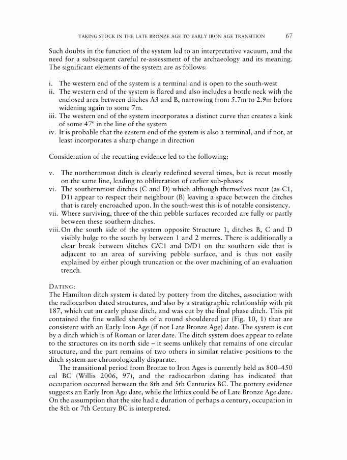
TAKING STOCK IN THE LATE BRONZE AGE TO EARLY IRON AGE TRANSITION 67
Such doubts in the function of the system led to an interpretative vacuum, and theneed for a subsequent careful re-assessment of the archaeology and its meaning.The significant elements of the system are as follows:
i. The western end of the system is a terminal and is open to the south-westii. The western end of the system is flared and also includes a bottle neck with the
enclosed area between ditches A3 and B, narrowing from 5.7m to 2.9m beforewidening again to some 7m.
iii. The western end of the system incorporates a distinct curve that creates a kinkof some 47º in the line of the system
iv. It is probable that the eastern end of the system is also a terminal, and if not, atleast incorporates a sharp change in direction
Consideration of the recutting evidence led to the following:
v. The northernmost ditch is clearly redefined several times, but is recut mostlyon the same line, leading to obliteration of earlier sub-phases
vi. The southernmost ditches (C and D) which although themselves recut (as C1,D1) appear to respect their neighbour (B) leaving a space between the ditchesthat is rarely encroached upon. In the south-west this is of notable consistency.
vii. Where surviving, three of the thin pebble surfaces recorded are fully or partlybetween these southern ditches.
viii. On the south side of the system opposite Structure 1, ditches B, C and Dvisibly bulge to the south by between 1 and 2 metres. There is additionally aclear break between ditches C/C1 and D/D1 on the southern side that isadjacent to an area of surviving pebble surface, and is thus not easilyexplained by either plough truncation or the over machining of an evaluationtrench.
DATING:The Hamilton ditch system is dated by pottery from the ditches, association withthe radiocarbon dated structures, and also by a stratigraphic relationship with pit187, which cut an early phase ditch, and was cut by the final phase ditch. This pitcontained the fine walled sherds of a round shouldered jar (Fig. 10, 1) that areconsistent with an Early Iron Age (if not Late Bronze Age) date. The system is cutby a ditch which is of Roman or later date. The ditch system does appear to relateto the structures on its north side – it seems unlikely that remains of one circularstructure, and the part remains of two others in similar relative positions to theditch system are chronologically disparate.
The transitional period from Bronze to Iron Ages is currently held as 800–450cal BC (Willis 2006, 97), and the radiocarbon dating has indicated thatoccupation occurred between the 8th and 5th Centuries BC. The pottery evidencesuggests an Early Iron Age date, while the lithics could be of Late Bronze Age date.On the assumption that the site had a duration of perhaps a century, occupation inthe 8th or 7th Century BC is interpreted.

LIVESTOCK MANAGEMENT
Droveways?The system occupies the north-facing slope of a stream valley which is not anobvious location for a trackway, but is not at risk of flooding and need not bedismissed. Consideration of the micro-topography, however, demonstrates thatthere are slight variations in the slopes in this part of the valley side, and any suchtrack would have either wandered up and down the valley side to have maintainedany consistency in level, or undulated gradually up and down over the various drygullies that dissect the valley side. However the very need for a droving track to beenclosed and prescribed in such a manner is questioned (cf Hindle 1993, 72).Firstly, our terminology needs improvement. The National Monuments RecordThesauri (English Heritage 2008) defines a drove road (to be used for droveway) as‘A road or track specifically used by drovers or herders to drive their animals tomarket.’ Such a definition, a product of the historic development of droving,specifically the long distance movement of livestock on the hoof over hundreds ofmiles on established routes from peripheral pasture to urban centres ofconsumption that proliferated in the 18th and 19th centuries (Hindle 1993, 72), isnot particularly useful in the discussion of prehistoric livestock control. Theprovision of enclosed tracks to facilitate the movement of animals between perhapsupland and lowland grazing areas on a small scale, or from pasture to even a verylocal market would have required substantial investment in infrastructure and wassurely only functionally necessary where routes passed immediately adjacent tosettlements, gardens or arable areas at certain times of year; the successfulmovement of sheep or cattle through open land could have depended upon theskills of the herders rather than confinement by ditches, banks and hedges.Nonetheless, ditched trackways running adjacent to enclosures are common in thearchaeological record, and require explanation. Examples from Late Iron AgeYorkshire running between and adjacent to regularly spaced small farmsteads havebeen interpreted as ‘liminal channels’ (Giles 2007, 241) where the flow of peopleand their animals could be scrutinised and controlled, the enclosed settlementeffectively cocooned from the outside world. The addition of such a socialrequirement for such structures helps illuminate a picture that otherwise remainsunclear. However this analogy comes from a Late Iron Age and probably sedentarysettlement pattern in a landscape that had rapidly infilled, and is not easilyapplicable here.
Crowding-AlleyThe ditch system is interpreted as a livestock management engine, intentionallyusing the slight softening in the slope, with evidence of holding enclosures andaccommodation to the north and is hereinafter referred to as a crowding-alley.The 120m or more long alley was a major construction; with internal banks andhedges, the internal area was still over 400 square metres (not including thefunnel), which could have held perhaps 1,000 sheep, or 150 cattle, and wouldhave been awkward to use with many fewer (cf Pryor 1996, 317).
68 MATTHEW BEAMISH AND MARTIN SHORE

TAKING STOCK IN THE LATE BRONZE AGE TO EARLY IRON AGE TRANSITION 69
The eastern extent of the alley, and the extent of any holding enclosures areunclear due to the excavation limits, and therefore the scale of any activities beingcarried out on the site is difficult to assess. Nonetheless it is clear that this was asubstantial construction whether extended to the east or not.
The flared ditches at the eastern end appear as a curving funnel into whichstock could be driven. Such curved alleys are commonplace amongst moderncattle handlers (Fig. 14; Turner 2004, 1), as contemporary animals are lesshesitant when driven along a curving wall or fence as opposed to a straight one.The curved funnel potentially served two functions. The first was to enableanimals to be driven into a holding area, and as such the alley could have served asa corral for animals entering from the west. The second function of the curve isalso suggested by the clear bottle-neck created between the inner ditches (A andB). This narrowing has been intentionally created, and is interpreted as aprocessing crush. Here an animal could be restrained for treatment (hoofs, teeth,parasites), processing (such as castration or branding), or slaughtered. The line ofsight to such a crush is clearly limited from the east within the alley, whilst it isfully visible from the funnel and the area to the west (13). If this interpretation iscorrect it may imply that this part of the system was worked in a direction fromeast to west, although conversely it seems unlikely that the funnel was more fordriving animals out rather than driving them in. Therefore perhaps the alley
Fig. 13. Interpretation of the funnel with internal banks 0.80m wide, stippled, and earlierfeatures removed, showing the scale, and more limited line of sight of the bottle-neck
from the eastern as opposed to the western end.
Fig. 14. Example of a modern forcing pen (after Turner, 2004, 3).

performed multiple functions and worked both with animals moving from west toeast, and in reverse.
RacesAlthough the surfacing only survived very poorly, the areas in which the pocketsdid survive may have significance. The areas chosen to be surfaced will have beenthose areas that were most heavily trampled (or conversely where the surfacingsurvived had been most eroded by traffic). Of the four recorded patches, three areeither completely or mostly between the ditches B and D/D1 in the west, and B andC/C1 in the east.
If the ditches and gullies are considered to be substantially contemporary(albeit with elements of piecemeal recutting (A/A1, C/C1, D/D1 etc) such as wouldbe necessary to maintain the facility and ensure that drains continued to function)then it is quite feasible that the crowding alley also included a number of workingraces on the southern side (15). Animal races are designed to force animals intosingle-file so that they are effectively contained in a narrow corridor (Pryor 1996,317). At the end of the race there may be also a crush where individual animalscan be restrained (either with ropes or planks) for processing. As these single trackraces become more heavily trampled they will have needed surfacing to preventbecoming quagmires.
It is also apparent that there is a break in the southernmost ditches adjacent toan area of surfacing (C/C1 and D/D1). Although furrowing had caused truncationin this area, it seems unlikely that gullies did not survive the medieval furrow butsurfacing did. Therefore, it is argued that the gullies were designed to terminate inthis area, and that an exit from one race, an entrance to a second race, and an exitto either grazing or a holding pen are all represented. Preceding the metalling andwithin a slight widening in the race are two unexcavated post holes. The secondrace also widens part way down its length, and was also partly metalled.
Cattle or Sheep?
There is insufficient evidence to establish or exclude any species from beingfunnelled into the ditch system, although the scale of operation appearsinordinately large for sheep or goats; the clearer race on the southern side of thesystem was 1.50m between ditches, but there is no evidence for the width ofinternal banks. The bottle-neck at the western end was 3m between ditches.Modern adjustable cattle handling alleys can vary between 0.40m to 0.80m, witha head gate crush adjustable between 0.25m and 0.80m. The scale of the alleytherefore seems well suited to cattle but could have equally been used for smalleranimals with the use of hurdles to narrow specific areas.
Landscape and economy
The sparse quantity of cereals on this site, in common with some other sites fromthis period (Monckton 2004, 157), may mean that cereal production was not
70 MATTHEW BEAMISH AND MARTIN SHORE

TAKING STOCK IN THE LATE BRONZE AGE TO EARLY IRON AGE TRANSITION 71
widely practiced in this area. It may also mean that only part of the period’seconomy or subsistence is reflected and that the site was used seasonally as apasturing or processing area and was only occupied for parts of the year. The scaleof the crowding-alley is very large – much larger than would be needed by a smallholder on today’s terms. There is clearly a possibility on the basis of these twopremises, that it represents a device that would have been used by groups offarmers working together and not by individual families.
The handling of large herds is attested in later periods where funnels up to 60mwide have been recorded in Nottinghamshire, and south and west Yorkshire (AdrianChadwick pers. comm.), with specific examples from Collingham, Nottinghamshire(Bishop 2001, 4) and Dunston Heath, Lincolnshire (Boutwood 1998, 44), while thelack of enclosure on Late Bronze Age and Early Iron Age sites within the region, hasbeen interpreted as a possible indicator of transhumance within an unboundedlandscape (Knight 2007, 193; cf Taylor 1996). Where further information has beengleaned from bone assemblages and midden sites of Late Bronze Age date in otherregions, interpretations of large scale specialist stock handling have also been made(Brück 2007, 32).
Late Bronze Age/Early Iron Age agriculture focussed on pastoralism has forsome time been identified in the river valleys of the Lower Welland and Nene tothe east and south-east (Taylor 1996, 233). The base of a pastoral economy isargued to require large tracts of cleared land as the dramatic increase in numbersof animals requires more extensive areas of grazing over the winter months. Thetending and movement of herds over these large areas would have required anelement of the population at least, to be mobile (Taylor 1996, 233). Althoughevidence of cereal cultivation is emerging from some sites of this period(Monckton 2006, 268) areas of difference perhaps existed.
The Hamilton alley may therefore represent specialist pastoralism occupiedon a seasonal basis. It appears to indicate animal management on a large scaleand may have resulted from different communities combining their resources.It is possible that this site was used seasonally with stock tending groups havingother areas of (equally ephemeral) settlement elsewhere. The excavation,therefore, has revealed important information on animal husbandry practisedaround 700–500 BC.
The wider landscape
The site forms a small part of an area of known and emerging Late Bronze Ageand Iron Age activity in the hinterland of Leicester (Fig. 16). Archaeological workin the vicinity of the development area since 1998 has located substantial areas ofIron Age settlement 1km to the south west (MLC567, MLC1305 and MLC1434;Charles et al 2000; Thomas 2003).
Comparison with other known Later Bronze Age and Iron Age evidence in thevicinity clarifies some patterning in the record. Late Iron Age settlements at CrownHills (MLC1223; Chapman 2000), Humberstone (Willis 2006, 101) and cropmarks of enclosures in Beeby (MLE451) and Barkby parishes (MLE419) are all

72 MATTHEW BEAMISH AND MARTIN SHORE
Fig.
15.
Inte
rpre
tati
onof
the
Ham
ilton
crow
ding
alle
yan
dpr
oces
sing
race
s.

TAKING STOCK IN THE LATE BRONZE AGE TO EARLY IRON AGE TRANSITION 73
located on the ends of the low parallel ridges that dominate this part of easternLeicestershire. Along with the development of the probable tribal capital atLeicester on a slight ridge which effectively narrows the valley at this point,further Late Iron Age settlement is probable at Rushey Mead, where a crouchedinhumation pit burial was located (Pollard 2001, 20) while circular crop marks(probably from a number of roundhouses) and further incidences of Iron Age findseach side of the river are known from Thurmaston (MLE6549) and Birstall(MLE5919).
Middle Iron Age sites have been recorded on the lower terraces of the Soar atWanlip (MLE1091; Beamish 1998) but also on the crest of the valley side atBeaumont Leys (MLC1484; Thomas 2007). Earlier sites of Later Bronze Age orEarly Iron Age date such as the Hamilton site (MLC662) described here, aresuggested on the opposite side of the Melton Brook stream valley (MLE493 andMLE449) where occupation appears just down slope from the crest of the ridge,and on the lower slopes of the ridge above the Soar valley to the west (MLE445),while Late Bronze/Early Iron Age burials came from palaeochannel deposits of theRiver Soar at Birstall (MLE8438) and Late Bronze Age metalwork (not securelylocated) from the lower valley side also in Birstall (MLE6280). The location ofLate Bronze Age and Early Iron Age occupation on the valley sides, as opposed tovalley bottom or top, has some parallels (Parry 2006, 65).
Late Bronze Age occupation within the Wreake valley to the north-east, hasbeen identified at Eye Kettleby, Melton Mowbray (Finn 1998) and more recentlyat Rearsby (Beamish and Clarke 2008, 44 and this volume, ‘Rearsby bypass roadscheme’), both examples including evidence of nearby pit alignments. Furtherstretches of pit alignment have been recorded nearer to Hamilton to the north, onthe western edge of Barkby (MLE434 and MLE435).
CONCLUSIONS
This site provides an important example of rarely located Late Bronze Age toEarly Iron Age occupation in the county. The essentially open and somewhatsparse nature of the occupation makes identification difficult, and this is reflectedin the known distribution of similar sites.
The site is interpreted as comprising a stock management system adjacent toaccommodation areas; the scale of the ditch system is substantial and could havecatered for hundreds of cattle. Such a facility is clearly at odds with models ofsmall scale agricultural production, with the implication that there was significantorganisation and specialisation in livestock farming at this time, and possiblypastoralism. Such an imbalance is also reflected in the dichotomy between thelarge scale land divisions that start to be formed in this period, and the knownsettlement record. The domestic archaeology of the site shows the continued use ofthe round house, albeit in less formalised and patterned form than existed inearlier and later periods.
The occupation of the site is interpreted as having occurred in the eighth orseventh centuries cal BC, on the basis of radiocarbon dating and the finds.

74 MATTHEW BEAMISH AND MARTIN SHORE
Fig.
16.
The
Nor
thH
amilt
onsi
te(A
)in
rela
tion
tose
lect
edL
eice
ster
(ML
C)
and
Lei
cest
ersh
ire
(ML
E)
His
tori
cE
nvir
onm
ent
Rec
ords
from
the
Mid
dle/
Lat
eB
ronz
eA
gean
dE
arly
Iron
Age
(whi
te)
and
Mid
dle
toL
ate
Iron
Age
(bla
ck)
toth
eno
rth
ofL
eice
ster
,w
ith
drai
nage
,co
ntou
rsan
dpa
rish
es.

TAKING STOCK IN THE LATE BRONZE AGE TO EARLY IRON AGE TRANSITION 75
MATTHEW BEAMISH is a Project Officer with University of LeicesterArchaeological Services.
ACKNOWLEDGMENTS
Thanks go to Martin Shore, Tim Higgins (site directors), Andy Hyam, KeithJohnson, Roger Kipling and Claire Strachan who excavated the site; Martin Shorealso produced the initial excavation report. Many thanks go to Martin Ward ofMather Jamie for facilitating the fieldwork on behalf of the clients, and to HelenWells (Historic Environment Record Officer, Leicestershire County Council) andChris Wardle (City Archaeologist, Leicester City Council) for supplying the HERdata. Thanks to Michael Hawkes for drawing the pottery at short notice, and toAdrian Chadwick, Jeremy Taylor and Patrick Clay for reading the text, and theirhelpful comments, suggestions and parallels, and to Derek Hamilton for advice onthe radiocarbon. Thanks again to Patrick Clay for his support and patience.Richard Clark was the Leicester City Council Planning Archaeologist and therecording was funded by Humberstone and Elms Farm Trust.
BIBLIOGRAPHY
Beamish, M. G., 1998 ‘A Middle Iron Age Site At Wanlip, Leicestershire’, TLAHS 72,1–91.
Beamish, M. G., 2003 ‘Hamilton Northern Housing Area (SK633 074)’, TLAHS 77,131.
Beamish, M. G, 2005 ‘Bronze Age Settlement At Ridlington, Rutland’, TLAHS 79,1–26.
Beamish, M. G. and A607 Rearsby Bypass. Unpublished excavation report. ULAS,Clarke, S. J., 2008 Report 2007–057.Boutwood, Y., 1998 ‘Prehistoric Linear Boundaries in Lincolnshire and its Fringes’ in
R. Bewley (ed.) Lincolnshire’s Archaeology from the Air,Occasional Papers in Lincolnshire Archaeology and History 11,29–46.
Bishop, M., 2001 East Midlands Archaeological Research Framework: ResourceAssessment of Roman Nottinghamshire. http://www.le.ac.uk/ar/research/projects/eastmidsfw/pdfs/25nottrom.pdf last accessed16–06–2008.
Brück, J., 2007 ‘Late Bronze Age settlement in Southern Britain’ in C. Haselgroveand R. Pope (eds) The Earlier Iron Age in Britain and the nearContinent, Oxbow Books, 24–38.
Chapman, S., 2000 ‘Crown Hills, General Hospital (SK 621 041)’, TLAHS 74,228–229.
Charles, B. M., ‘A Bronze Age ditch and Iron Age settlement at Elms Farm,Parkinson, A. and Humberstone, Leicester’, TLAHS 74, 113–222.Foreman, S., 2000Clay, P. and The excavation of a Romano-British settlement at Hamilton,Shore, M., 2004 North Humberstone Leicester (Site 1 SK 630730), ULAS Report
2004–188.

Clay, P., 2001 ‘Leicestershire and Rutland in the First Millennium BC’, TLAHS75, 1–19.
Clay, P., 1985 ‘The Late Iron Age settlement’ in P. Clay and J. E. Mellor,Excavations in Bath Lane, Leicester, Leicestershire MuseumsArchaeological Report No 9, 29–31.
Clay, P., 1992 ‘An Iron Age Farmstead at Grove Farm, Enderby, Leicestershire’,TLAHS 66, 1–82.
Clay, P. and Iron Age and Roman Occupation in the West Bridge Area,Pollard, R., 1994 Leicester. Excavations 1962–1971, Leicester: Leicestershire
Museums Arts and Records Service.Cooper, L. P., 1994 ‘Kirby Muxloe, A46 Leicester Western By-pass (SK 530 050)’,
TLAHS 68, 162–165.Cooper, N. J., 2000 The Archaeology of Rutland Water, Leicester: Leicester
Archaeology Monographs 6.Elsdon, S. M., 1992 ‘East Midlands Scored Ware’, TLAHS 66, 83–91.English Heritage, 2008 National Monuments Record Thesauri. London: English Heritage.Finn, N., 1998 ‘Melton Mowbray, Eye Kettleby, Leicester Road (SK 731 180)’,
TLAHS 72, 178.Ford, S., Bradley, R., ‘Flint-working in the Metal Age’, Oxford Journal of Arch. 3,Hawkes, J. and 157–173.Fisher, P., 1984Fowler, P. J., 1981 The Farming of Prehistoric Britain, Cambridge: Cambridge
University Press.Gilchrist, R. and ‘Experimental archaeology and burnt animal bone fromMytum, H. C., 1986 archaeological sites’, Circaea, vol. 4, no. 1, 29–38.Gent, H., 1983 ‘Centralized storage in Later Prehistoric Britain’, Proc. Prehist.
Soc. 49, 243–267.Gwilt, A. and Reconstructing Iron Age Societies. New Approaches to the BritishHaselgrove, C. C. Iron Age, Oxbow Monograph 71, Oxford: Oxbow.(eds), 1997Giles, M., 2007 ‘Good fences make good neighbours? Exploring the Ladder
Enclosures of Late Iron Age East Yorkshire’, in C. Haselgrove andT. Moore (ed.) The Later Iron Age in Britain and Beyond.Oxford: Oxbow Books, 235–249.
Hindle, B. P., 1993 Roads, Tracks and their Interpretation. Batsford.Jackson, D. A. and ‘Early Iron Age and Beaker Site near Gretton’, NorthantsKnight, D., 1985 Archaeology 20.Jackson, D. A., 1976 ‘Two Iron Age Sites North of Kettering, Northamptonshire’,
Northants Archaeology 11.Knight, D., 2007 ‘From open to enclosed: Iron Age landscapes of the Trent valley’,
in C. Haselgrove and T. Moore (ed) The Later Iron Age in Britainand Beyond. Oxbow Books, 190–218.
Marsden, P. L., 1998 ‘The Iron Age pottery’ in M. Beamish, 1998 ‘A Middle Iron Agesite at Wanlip, Leicestershire’, TLAHS 72, 44–62 (pp. 1–91).
Marsden, P. L., 2000 ‘The prehistoric pottery’ in B. M. Charles et al., 2000 pp.170–186.
Marsden, P. L., 2008 ‘The Prehistoric Pottery from Site 2 (XA36 2004 and XA822003)’ in M. Beamish and S. Clarke, 2008.
76 MATTHEW BEAMISH AND MARTIN SHORE

TAKING STOCK IN THE LATE BRONZE AGE TO EARLY IRON AGE TRANSITION 77
Meek, J., Shore, M. ‘Iron Age Enclosures at Enderby and Huncote, Leicestershire’,and Clay, P. N., 2004 TLAHS 78, 1–34.Monckton, A., 2004 ‘Investigating the early environment in Leicester, Leicestershire
and Rutland’ in P. Bowman and P. Liddle, 2004 LeicestershireLandscapes. Leicestershire Museums Archaeological FieldworkGroup Monograph 1. Leicester: Leicestershire County Council,154–171.
Monckton, A., 2006 ‘Environmental Archaeology in the East Midlands’ in N. J.Cooper(ed.) The Archaeology of the East Midlands. An ArchaeologicalResource Assessment and Research Agenda. Leicester: LeicesterArchaeology Monograph 13, 259–286.
Oswald, A., 1997 ‘A doorway on the past: practical and mystical concerns in theorientation of roundhouse doorways’ in A. Gwilt and C. C.Haselgrove (eds) Reconstructing Iron Age Societies. NewApproaches to the British Iron Age. Oxbow Monograph 71,Oxford: Oxbow, 87–95.
Parry, S., 2006 Raunds Area Survey. An archaeological study of the landscape ofRaunds, Northamptonshire 1985–94. Oxford: Oxbow Books.
PCRG, 1995 The Study of Later Prehistoric Pottery: General Policies andGuidelines for Analysis and Publication. Prehistoric CeramicsResearch Group Occasional Papers 1 and 2.
Pollard, R. J., 2001 ‘An Iron Age Inhumation from Rushey Mead, Leicester’, TLAHS75, 20–35.
Pope, R., 2007 ‘Ritual and the roundhouse’ in C. Haselgrove and R. Pope (eds)The Earlier Iron Age in Britain and the near Continent. OxbowBooks, 204–228.
Pryor, F., 1996 ‘Sheep, stockyards and field systems: Bronze Age livestockpopulations in the Fenlands of eastern England’, Antiquity 70,313–324.
Pryor, F., 2003 Britain B.C. Life in Britain and Ireland before the Romans.London: Harper Collins.
Smith, K. L., 2002 ‘Cattle Handling and Working Facilities’, Ohio State University,Bulletin 906.
Stace, C., 1991 New flora of the British Isles. Cambridge: Cambridge UniversityPress.
Stuiver, M. and ‘Extended C14 data base and revised calib 3.0 C14 calibrationReimer, P. J., 1993 program’, Radiocarbon 35.1, 215–230.Taylor, J., 1996 Iron Age and Roman Landscapes in the East Midlands: A Case
Study in Integrated Survey Unpublished PhD thesis, University ofDurham.
Thomas, J., 2003 ‘Manor Farm, Keyham Lane (SK 6275 0652 centre)’, TLAHS 77,131–132.
Thomas, J. S., 2007 ‘Beaumont Leys Lane, Beaumont Leys, Leicester (SK 5760 0863)’,TLAHS 81, 174–176.
Turner, S., 2004 ‘Recommendations for the design of new, safe and efficient cattlehandling systems’, Scottish Agricultural College Technical Note565.
Webley, L., 2007 ‘Using and Abandoning Roundhouses’, Oxford Journal ofArchaeology 26(2), 127–144.

Willis, S. H., 1997 ‘Settlement, materiality and landscape in the Iron Age of the EastMidlands: evidence, interpretation and wider resonance’ in A.Gwilt and C. Haselgrove (eds) 1997 Reconstructing Iron AgeSocieties. Oxford: Oxbow Monograph 71, 205–215.
Willis, S. H., 2002 ‘A date with the past: Late Bronze and Iron Age pottery andchronology’ in A. Woodward and J. D. Hill (eds) PrehistoricBritain: The Ceramic Basis. Oxford: Oxbow Monograph, 4–23.
Willis, S. H., 2006 ‘The Later Bronze And Iron Age’ in N. J.Cooper (ed) TheArchaeology of the East Midlands. An Archaeological ResourceAssessment and Research Agenda. Leicester: LeicesterArchaeology Monograph 13, 89–136.
Zohary, D. and Domestication of plants in the Old World. (2nd ed.) Oxford:Hopf, M., 1993 Clarendon Press.
78 MATTHEW BEAMISH AND MARTIN SHORE