
TABLE OF CONTENTS - · PDF fileProjects 2006\RRPC\Berwick Hotel Site\Supplemental Phase II...
31
Transcript of TABLE OF CONTENTS - · PDF fileProjects 2006\RRPC\Berwick Hotel Site\Supplemental Phase II...


TABLE OF CONTENTS
E CUTIVE SUMMARY.............................................................................................. .. ...XE ...................... 1 ....................... .3 ...................... 4 ...................... 4 ...................... 4 ...................... 5 ...................... 5 ...................... .5 ...................... 9 ...................... 9 ...................... 9 ...................... 0 ...................... 0 ...................... 0 ...................... 1 ...................... 1 ...................... 1 ....................... ...................... 2 ...................... 2 ...................... 3 ...................... ...................... ...................... 5 ...................... 5 ...................... 6 ...................... ...................... 7 ...................... 8
7.3 ASSESSMENT/OVERSIGHT................................................................................................................. 7.4 DATA EVALUATION AND USABILIT ................................................................................................ 9
8.0 FINDINGS & CONCLUSIONS...........................................................................................................20 9.0 RECOMMENDATIONS ......................................................................................................................23 10.0 REFERENCES ....................................................................................................................................24
..
..
..
..2.2 SAMPLING AND ANALYTICAL TESTING ......................................................................
.. ..
..
..
....
....
...
....
....
....
....
....
....
....
....
....
....
....
....
....
....
....
....
....
....
1.0 INTRODUCTION & BACKGROUND ........................................................... .. .
2.0 S W ... ................................................................................. ..COPE OF ORK..... ........... ...
2.1 SUPPLEMENTAL SUBSURFACE INVESTIGATION ..................................................... .. ....
2.4 REPORTING ............................................................................................................. ....2.5 INTERIM CORRECTIVE ACTION PLAN PREPARATION ........................................... ..
3.0 CONCEPTUAL MODEL.......................................................................................... .. ..
4.0 SUBSURFACE INVESTIGATION........................................................................ ..
..
...
4 ORI INSTALLATION................................................................................ ..4.2 SOIL & SLUDGE SAMPLE COLLECTION................................................................ ...
1
.1 SOIL B NG..
4.3 SITE GEOLOGY...................................................................................................... ..14.5 SITE PLAN.............................................................................................................. ..14.6 RECEPTOR SURVEY............................................................................................... ..
.15.0 GROUND-WATER SAMPLE COLLECTION .................................................... ..
15.1 GROUND-WATER ELEVATIONS AND FLOW DIRECTION ...................................... ..5.2 GROUND-WATER SAMPLE COLLECTION ............................................................. ..
12
1
6. .
1
0 ANALYTICAL RESULTS ..................................................................................... ..
16.1 SOIL & SLUDGE RESULTS .....................................................................................
1
..
14
6.1.1 Soil Borings ................................................................................................... ..6.1.2 Sludge Samples ............................................................................................. ..
141
6.2 GROUND-WATER QUALITY RESULTS .................................................................. ..
1
6.2.1 Volatile Organic Compounds ....................................................................... ..
1
6.2.2 Semi-Volatile Organic Compounds .............................................................. ..
.17
6.2.3 Polychlorinated Biphenyls ............................................................................ ..6.2.4 Metals ............................................................................................................
1
..
1
7.0 QUALITY ASSURANCE/QUALITY CONTROL ............................................... ..
1818
7.1 FIELD QUALITY CONTROL ................................................................................... ..
1
7.1.1 Field Notes..................................................................................................... ..7.2 LABORATORY QUALITY CONTROL ..................................................................................................
Y
Q:\Env. Projects 2006\RRPC\Berwick Hotel Site\Supplemental Phase II ESA\SupplementalPhase II ESA Report.doc i

Q:\Env. Projects 2006\RRPC\Berwick Hotel Site\Supplemental Phase II ESA\SupplementalPhase II ESA Report.doc ii
ENCLOSURES
2 SITE PLAN AN
GROUND-WATER ANALYTICAL RESULTS – VOCs ANALYTICAL RESULTS – SVOCs
ALYTICAL RESULTS – METALS
GEOLOGIC LOGS
ATTACHMENTS
1 LABORATORY REPORTS (ORIGINAL) 2 LABORATORY REPORTS (RE-ISSUED) 3 INTERIM CORRECTIVE ACTION PLAN (iCAP)
FIGURES 1 SITE LOCATION MAP
3 GROUND-WATER CONTOUR PL
TABLES 1 GROUND-WATER TABLE ELEVATIONS 2 3 GROUND-WATER 4 GROUND-WATER AN
APPENDICES 1 2 LOW FLOW SAMPLING LOGS 3 WATER QUALITY DATA 4 DATA VALIDATION CHECK LISTS

EXE UTIVE SUMMARY
Leggette, f the recent rwick Block,
Herald property located along Wales Street between Willow and Center Streets in the City e Site).
C
The professional hydrogeologic and environmental consulting firm ofBrashears & Graham, Inc. (LBG) is pleased to present the results oSupplemental Phase II Environmental Site Assessment (ESA) at the Beincluding the Berwick Hotel Site (now a gravel municipal parking lot) and Rutland
of Rutland, Vermont (th Background – Phase I ESA A previous Phase I ESA conducted by LBG, indicates the past lan
Site, include a hotel, shops, a dry cleaners, a dyers and cleaners, residentiand auto sales facility and more recently the Rutland Herald pressroom. Thwith shops and the dry cleaners were destroyed by fire in 1973. The identified
d uses at the al use, garage e former hotel Phase I ESA
several recognized environmental conditions in regards to past Site land uses, buried building m adjacent and nearby properties. The Phase I ESA nvironmental
aterials and past uses of report recommended a Phase II ESA to investigate these recognized e
conditions. Background – Phase II ESA During the recent Phase II ESA conducted by LBG, multiple
including asbestos, volatile organic compounds (VOCs), semi-volacompounds (SVOCs), polychlorinated biphenyls (PCBs), and several investigated. The presence of chrysotile asbestos was confirmed in four tethe parking lot and multiple contaminants were detected above the US EPPreliminary Remediation Goals (PRGs) for industrial properties in the collected from the Site and in sed
contaminants tile organic metals, were st pits within A Region 9
soil samples iment samples collected from the Rutland Herald floor
drain system. In addition, multiple contaminants were detected in ground-water samples from round-water
e laboratory erald in areas
the Site at concentrations exceeding their applicable Vermont GEnforcement Standard (VGES). PCBs were not detected above thquantification limits (QLs) in concrete samples collected in the Rutland Hwhere transformers were formally used.
Supplemental Phase II ESA For this supplemental investigation, LBG installed a series of soil borings to
furt parking lot in leaner in this s, while two
for industrial properties. Based on this data, if soil was excavated from this area, it may be considered a listed hazardous waste (F002).
LBG collected sludge samples from the Rutland Herald sub-grade basement below the former plate and dark rooms for disposal purposes. The results indicate elevated arsenic and total petroleum hydrocarbon concentrations, but do not exhibit the characteristics of a hazardous waste. An interim Corrective Action Plan (iCAP)
her investigate the soil quality along the western portion of the gravel regards to chlorinated VOCs resulting from the past operation of a dry carea. Multiple chlorinated compounds were detected in three soil boringchlorinated VOCs were detected above the US EPA Region 9 PRGs
Q:\Env. Projects 2006\RRPC\Berwick Hotel Site\Supplemental Phase II ESA\SupplementalPhase II ESA Report.doc 1

specifically for the sub-grade basement for the Rutland Herald building, which was previously recommended in the Phase II ESA, has been prepared.
samples from and metals. Variability in ground-water
con rations was observed.
In addition, LBG collected a confirmation round of ground-water
on-Site monitor wells for VOCs, SVOCs, PCBstaminant concent
Recommendations Contaminant concentrations tend to naturally fluctuate in ground wa
governed by a host of environmental conditions. Concentrations willseasonally, as environmental conditions on-Site alter the solubility of contamay exceed the VGES on occasion. Due to the fluctuating concentratiocontaminants in the ground water migrating through the Site LBG developing a long term grou
ter as they are likely vary minants, and
ns of various recommends
nd-water monitoring program for select wells and chemical param -1 and MW-2
may change
eing prepared aracterization
of the Rutland Herald Bui collection of
ended. LBG mp within the is.
r of the main y if the use of ng at this time or, which will
acilitate oval will
require waste stream characterization sampling and testing prior to moving any materials off-Site. Dewatering prior to excavation will also be needed and treatment of the ground water may be required prior to discharge. The CAP should also be designed to utilize activity and use restrictions such as avoiding sub-grade basements reducing the need to pump, treat and discharge ground water and restricting residential occupancy on the
Records will likely be required.
eters. LBG proposes collection of ground-water samples from MWfor total petroleum hydrocarbon fingerprinting. Redevelopment of the Siteaspects of the monitoring program.
Considering the data collected thus far and the preliminary plans b
for future redevelopment of the Site, LBG suggests waste stream chsampling and testing prior to moving any excavated materials off-Site.
If future Site development includes removing the floor
lding or demolishing any portion of the Rutland Herald Building, shallow soil samples from beneath the floor for PCB analysis is recommproposes collecting ground-water samples from MW-1, MW-2, and the susub-grade basement; and collecting samples from the sludge for PCB analys
In the future, collection of an air quality sample on the ground floo
Rutland Herald building, in the area of MW-10, may be prudent (especiallthe space changes). However, LBG does not recommend indoor air samplidue to the items stored in the area and vehicle traffic within the ground flolikely interfere with sample data.
A Corrective Action Plan for specific areas that will be disturbed to f
construction is recommended. For example, future excavations and debris rem
ground floor. Notice to Land
Q:\Env. Projects 2006\RRPC\Berwick Hotel Site\Supplemental Phase II ESA\SupplementalPhase II ESA Report.doc 2

1.0 INTRODUCTION & BACKGROUND
ase II ESA at cipal parking
Streets in the City of Rutland, Vermont (the Site). The Site location is depicted on Fig
erly wetland otel in 1868.
-49 Center Street) containing shops, was later incorporated into the hotel. The Berwick Hotel was lot. Building
as 43-45 Center Street, was dev tion occupied
e former dry
869 and later ck Hotel with rooms above the shops. A portion of the
bui 1925 to circa rebuilt as the the adjacent
ere developed ite remained
6 when a garage and auto sales facility was constructed that included a gasoline underground storage tank (UST) and pumps. The Rutland Herald mo illow Street,
er 1925 when nd service facility was constructed. The Rutland Herald began leasing this
bui ain Rutland
onditions in regards to past Site land uses, buried building materials and past uses of adjacent and nearby properties.
During a recent Phase II ESA, LBG investigated buried building debris by excavating test pits, floor drain systems by collecting sediment samples, concrete where former transformers were stored by collecting concrete samples for laboratory analysis, soil quality by installing and sampling soil borings, and ground-water quality by
LBG is pleased to present the results of the recent Supplemental Ph
the Berwick Block, including the Berwick Hotel Site (now a gravel munilot) and Rutland Herald property located along Wales Street between Willow and Center
ure 1, Site Location Map. Based on a recent Phase I ESA conducted by LBG, the area was form
and the Berwick Site (51-55 Center Street) was later developed as a hVarious shops were located within the Berwick Hotel and the adjacent building (47
destroyed by fire in 1973 and is now used as a municipal parking debris can be observed at the surface of the gravel lot.
The western portion of the parking lot on-Site, known
eloped as shops in 1879. Dominic Paul, a tailor, and dry cleaners operathe Site in circa 1946 until the building was destroyed by fire in 1973. Thcleaner property is also incorporated into the gravel municipal parking lot.
The newsroom Site was developed as shops between 1854 and 1
incorporated into the Berwildings appears to have been occupied by a dyers and cleaners from circa
1935. This building was also destroyed by fire in 1973. This building wasRutland Herald newsroom in the mid 1970’s after the fire and connected toRutland Herald pressroom building.
The main Rutland Herald building and Rutland Herald pressroom w
as residential units between 1854 and 1869. Along Wales Street the Sresidential until circa 191
ved into the garage (main Rutland Herald building) circa 1934. Along Wthe Rutland Herald pressroom Site remained residential with shops until aftan a to sales au
lding in the 1960’s, eventually purchased the building and joined the mHerald and pressroom buildings.
The Phase I ESA identified several recognized environmental c
Q:\Env. Projects 2006\RRPC\Berwick Hotel Site\Supplemental Phase II ESA\SupplementalPhase II ESA Report.doc 3

installing and sampling monitor wells. The presence of chrysotile asbestos win four test pits within the parking lot. VOCs, SVOCs, a PCB, and severadetected above the US EPA Region 9 PRGs for industrial properties in thecollected. Of the sediment samples collected from the Rutland Herald floor1,4-dichlorobenzene and arsenic were detected above the US EPA Regioindustrial properties. PCBs were not detected above the laboratory
as confirmed l metals were soil samples
drain system, n 9 PRGs for
quantification limits (QL
A monitoring Benzene and eir applicable
detected above the VGES in any monitor well samples collected. Antimony, arsenic, cad ter above the
the Rutland
top of the concrete slab. The soil was stained and emanated petroleum odors. The two hea SA, that were
of the Rutland Herald pressroom have been rem
commended additional environmental work at the
Site. The results of the Supplemental Phase II ESA are detailed in this report.
llation of eight (8) soil borings using Geoprobe® tools and direct push technology while continuously screening the soils for VOCs with a pho ere along the
to determine uality.
LBG anticipated the collection of eight (8) soil samples from the soil borings for laboratory analysis for VOCs to determine if past on-Site activities have impacted soil quality.
LBG proposed to collect two composite and grab samples of soil/sludge from the Rutland Herald sub-grade basement below the former plate room for laboratory analysis by the Toxicity Characteristic Leaching Procedure (TCLP) for VOCs, SVOCs, RCRA 8
s) in either concrete sample collected in the Rutland Herald. Based on ground-water elevations collected during the Phase II ES
event, ground-water flow has been interpreted to be northwesterly. naphthalene were detected in ground water at concentrations exceeding thVermont Ground-water Enforcement Standard (VGES). No target SVOCs or PCBs were
mium, copper, lead, manganese, and silver were detected in ground waVermont standards.
Within the sub-grade basement below the former plate room of
Herald pressroom, petroleum impacted soil and highly oxidized sludge were observed on
ting oil ASTs, no longer in use and previously identified in the Phase I Ewithin the sub-grade basement below the former plate room
, oved by others.
The Phase II investigation re
2.0 SCOPE OF WORK
2.1 Supplemental Subsurface Investigation
LBG proposed the insta
toionization detector (PID). The proposed soil boring locations wwestern edge of the gravel parking lot in the area of the former dry cleanersoil q
2.2 Sampling and Analytical Testing
Q:\Env. Projects 2006\RRPC\Berwick Hotel Site\Supplemental Phase II ESA\SupplementalPhase II ESA Report.doc 4

metals, and ignitability, corrosivity, and reactivity. The VOC samples were to be the grab samples.
(19) wells for . In addition,
ct wells for SVOCs by U.S. EPA Method ist) and PCBs by U.S. EPA Method 8082.
al data, LBG endations
relevant to the Site, which includes data tables, figures, graphical depiction of data, and a rior to accepting analytical data into the report,
LBG validated the laboratory data.
iCAP) limited ; closing the in the main
soil/sludge within the Rut , cleaning and
utland Herald l iCAP work rs.
the sub-grade e the Rutland Herald must cease operating the pump or
see des a plan to uilding codes
to ceiling height and existing utilities in the sub-grade basement were considered. This scope of work does not in al implementation and oversight of the iCAP described
utland Herald provided as
3.0 CONCEPTUAL MODEL
Based on the Phase I ESA, the suspected contaminants from previous on-Site and
off-Site uses include volatile organic compounds (VOCs), metals, semi-volatile organic compounds (SVOCs), polychlorinated biphenyls (PCBs), and asbestos containing materials (ACMs). The suspected locations of potential contamination are in the areas of
LBG proposed to collect ground-water samples from all nineteen
laboratory analysis of VOCs via U.S. EPA Method 8260 and total metalsLBG proposed ground-water analysis of sele8270 (full l
2.4 Reporting
Upon completion of all field work and receipt of the analyticprepared a detailed summary report including summaries, findings, and recomm
copy of the complete analytical report. P
2.5 Interim Corrective Action Plan Preparation
LBG has proposed developing an interim Corrective Action Plan (to addressing the following: cleaning the Rutland Herald floor drain systemfloor drains within the pressroom and a portion of the floor drain systemRutland Herald building; and removing and disposing of the
land Herald sub-grade basement below the former plate room. Cuttingremoving two heating oil above ground storage tanks (ASTs) within the Rsub-grade basement below the former plate room was within the originaplan, however, these tanks have already been removed from the Site by othe
The continued operation of a sump pump in the sub-grade basement is currently
allowed to discharge to the waste water treatment plant (WWTP) until basement is cleaned. At that tim
k appropriate State and local approvals and permits. The iCAP inclubackfill the sub-grade basement to eliminate the need for the sump pump. Bpertaining
clude the actu above.
The iCAP, limited to the interior of the sub-grade basement of the R
(below the former plate room) and Rutland Herald floor drain system, isAttachment 3.
Q:\Env. Projects 2006\RRPC\Berwick Hotel Site\Supplemental Phase II ESA\SupplementalPhase II ESA Report.doc 5

the Site’s floor drain system, former ink tank, former heating oil ASTs, station, former gasoline UST and pump, former darkrooms, former printinformer lead melting pot, as well as beneath the municipal parking lot in thformer dry cleaner and boilers. The Data Quality Objectives (DQOs) fodesigned to determine the existing environmental conditions of the soil and within the Site boundaries and the potential contaminants that were backfithe fire. The purpose of the soil samples collected was to assess the dcontaminants in the subsurface. The collection of groun
former filling g presses, and e areas of the r this Site are ground water
lled following istribution of
d-water samples was designed to determ inants
ng lot during rick, marble,
s of peat and stone fragments. Deep structural borings conducted by others
indicate bedrock me presence of
it excavations the top of the
the test pits de of oil (No.
fraction was lost in the fire it is expected that the residual petroleum compounds are the hea unds are less
Despite low contaminated
y identified in ground-water e source may Street. MEK
dry cleaning, -water sample ry cleaner) in
the initial sampling round. In September 2008, LBG conducted a supplemental subsurface investigation of the former dry cleaner area in the gravel parking lot by
ngs. Of the eight soil samples, multiple chlorinated VOCs were detected, including PCE and its daughter compounds. PCE and trichloroethene (TCE) were detected above the PRGs for industrial properties. Data collected thus far indicates chlorinated solvent contamination may be present at low levels in ground water and is present at concentrations above the PRGs in soil beneath the municipal parking lot
ine if contaminants resulting from past Site activities and/or off-Site contamhave leached and/or migrated to the ground water beneath the Site.
The subsurface conditions encountered within the municipal parki
investigations include sand and gravel with charred building materials (broofing, tile, concrete, piping, timber, plastics, etc.) over silt with layergranite, marble and lime
ay be encountered at 23 to 42 feet bgs. Analytical data indicate arsenic in soil at concentrations exceeding the PRG for industrial properties and thACMs, including chrysotile.
Evidence of petroleum contamination was observed during the test p
for the ACM inspections. Visual observations showed some sheens on water after disturbing the soils above. PID measurements of the soils fromyielded relatively low concentrations of VOC vapors. Depending on the gra2, No. 4 or No. 6), the age of the oil and the fact that a large portion of the volatile
vier molecular weight compounds. The heavier, less volatile compolikely to dissolve in water and tend to adsorb to the soil particles. concentrations in the soil and ground water, soils within the parking lot arewith high molecular weight petroleum compounds.
MEK commonly used as a dryer and thinner in paints was previousl
well MW-19 located at the entrance to the parking lot during the May 2008sampling event; however, the concentration was well below the VGES. Thbe related to a former Paints and Varnish operation on the east side of Waleswas not detected above the QLs during the September 2008 event.
Tetrachloroethene (PCE), a chlorinated solvent commonly used in
was detected at a concentration below the enforcement standard in a groundfrom MW-12 (located at the presumed location of the rear of the former d
installing a series of soil bori
Q:\Env. Projects 2006\RRPC\Berwick Hotel Site\Supplemental Phase II ESA\SupplementalPhase II ESA Report.doc 6

in the former dry cleaner area. PCE, in its non-aqueous form, is heavier thhas a tendency to migrate downward. The vertical extent of PCE in underlying the Site is unknown. Off-Site ground water impacts from chlorinare unknown. The recent sampling event c
an water and ground water ated solvents
onducted in September 2008 did not indicate PCE
rald building xhibit limited able PRG for
al properties and the VGES; limited PCB soil contamination above the PRGs in B-7 for industrial
in the area of t, as well as
nd adjacent to ng and plating
specifically the sub-grade basement below the former dark room and in the coal storage bin lts for metals
h the elevated
ent below the ed soil/sludge
ony, arsenic, exceeding the MW-1. The
leum contaminated soil/sludge on the slab within the sub-grade basement below the form ID reading of
8,300 ppm – se metals and unicipal sewer
connected to ment samples -1 above the
VGES is consistent with the same group of metals with elevated levels in floor drain FD-2. The integrity of the floor drain system is currently unknown.
Analytical results indicate that ground-water beneath the Rutland Herald in the areas of the Site’s former heating oil ASTs and former filling station contain VOCs above the VGES. Although low level Polycyclic Aromatic Hydrocarbons (PAHs) remain in the soil and few VOCs are present within the ground water, considering the on-Site
concentrations in ground water above the QLs. The subsurface conditions encountered beneath the Rutland He
during these investigations include sand atop silt with layers of peat that eVOC and SVOC soil and ground-water contamination exceeding the applicindustri
(MW-7); and arsenic in soil with concentrations exceeding the PRGproperties.
Metal contaminated ground water exists beneath the Rutland Herald
the former darkroom, former printing presses, and former lead melting pobeneath the municipal parking lot in the areas of the former dry cleaners athe newsroom. Metals from past uses on-Site (photo darkrooms, lead meltiand printing presses) appear to have impacted the ground water beneath the Site,
s proximate to the former lead melting pot. Additionally, analytical resuin the floor drain show high concentrations of similar metals consistent witmetals found in the sub-grade basement below the former dark room.
The sump pump located within the Rutland Herald sub-grade basem
former plate room and near MW-1, MW-2 and the petroleum contaminatnoted on the slab, is reportedly connected to the municipal sewer system. The floor of the sub-grade basement is below the static ground-water table. Antimcadmium, lead and silver have been previously reported at concentrations VGES in MW-1. Lead concentrations continue to exceed the VGES in petro
er plate room of the Rutland Herald pressroom exhibited an elevated P9.0 ppmv, elevated total petroleum hydrocarbon (TPH) concentrations (160,000 ppm), and elevated arsenic concentrations. It is unknown if thepetroleum compounds (from the soil/sludge) are being discharged to the msystem.
The floor drain system within the Rutland Herald is reported to be
the City sewer system. SVOCs and metals have been detected in both sedicollected from the floor drain system. The group of metals found in MW
Q:\Env. Projects 2006\RRPC\Berwick Hotel Site\Supplemental Phase II ESA\SupplementalPhase II ESA Report.doc 7

observations, PID soil headspace screening results, and ground-water analypast on-Site oil storage tanks, gasoline storage tanks, garages and filling sand SVOCs from past Site use and products used on Site have impacted tobservations and data collected indicate the petroleum contamination observed on-Site is old and weathered having been degraded with minimal low mweight volatile compounds rem
tical data, the tation, VOCs he Site. Site detected and
olecular aining due to dilution and natural attenuation. Off-Site
gro
not appear as bove the PRG
a sample coll the covering
ry limited.
e sample) are and are also
concentration in Berwick soil samples (3 mg/Kg) to the USGS of 7.2 mg/Kg (Shacklette & B w the USGS
the PRG, to
lls and above hout the Site,
igrating to the Up-gradient igrating onto
MW-19, are
xhibits metal, ted levels of
occurring and urces. MW-19 is located adjacent to a former
pho d has shown senic in soil,
which have not been attributed to any off-Site sources. In May 2008, the copper concentration in MW-19 was elevated above the VGES while wells down-gradient (MW-12, MW-14 & MW-15) contained copper concentrations above the QL but below the
Concentrations of nickel and chromium have been detected above the VGES in
ground-water samples collected from MW-13 and MW-14. These wells are located
und water impacts are unknown.
The single PCB detected is in a boring within the Willow Street sidewalk. Sinceno other soil borings or monitor wells exhibited PCB contamination, it doesthough PCB contamination exists on Site. The detection of Archlor-1248 afor industrial properties for direct exposure in soil boring B-7 (MW-7) was from
ected at a depth of 8-10 feet bgs. Due to the depth of the soil sample andof the area by the concrete sidewalk, exposure to this contaminated soil is ve
The arsenic concentrations detected in the soil samples (except on
less than 10 mg/Kg, an informal standard of the Department of Health, below published values for soils in New England. Comparing the average arsenic
oerngenm, 1984), the Berwick average arsenic concentration is beloaverage. LBG does not believe the concentrations of arsenic, which exceedbe significant.
Manganese has been detected above the VGES within 17 of 19 we
the QLs in all wells. Since manganese concentrations are elevated througthis suggests that manganese may be naturally occurring.
With the data collected thus far, it is unclear if contaminants are m
Site from up-gradient sources, when so many on-Site sources are present.wells are where you would expect to see contaminants if contamination is mthe Site from off-Site sources. The three wells, MW-10, MW-18, andlocated along the eastern (up-gradient) side of the Site. However, MW-10 is located within the area of past on-Site gasoline, coal, heating oil and lead use and eVOC and SVOC impacted ground water. MW-18 only contains elevaarsenic in soil and manganese in ground water, which may be naturally have not been attributed to any off-Site so
to darkroom on the upper level of the Rutland Herald newsroom anelevated concentrations of copper and manganese in ground water and ar
VGES.
Q:\Env. Projects 2006\RRPC\Berwick Hotel Site\Supplemental Phase II ESA\SupplementalPhase II ESA Report.doc 8

within the gravel parking lot, down-gradient of the former darkroom located on the upper level of the Rutland Herald newsroom.
ember utilities on-Site, prior to any subsurface activities. The Dig Safe-assigned ticket numbers
06856 and 20081506840.
the Site using g direct push
techniques. Soil boring depths range from 4 to 12 feet bgs. Each boring was advanced as advanced,
techniques.
isobutylene standard referenced to benzene prior to screening. PID readings ranged from less -201 through
borehole are
on of the gravel parking lot included building materials (brick, marble, etc.) over silt with
granite, marble and limestone fragments. Ground water was encountered during this (bgs). Boring
8 , soil samples were collected from and
reserved with sample was of refusal on gs and 9 feet
readings and an oily appearance of material. On September 18, 2008, LBG personnel collected sludge samples from the sub-
grade basement below the former plate room of the Rutland Herald. The sludge samples VOC, TCLP SVOC, TCLP metals, total petroleum
hydrocarbons (TPH) as diesel range organics (DRO), total metals, reactivity, corrosivity, and ignitability analyses. The sludge collected for VOC analysis by EPA Method 8260B were preserved with methanol.
4.0 SUBSURFACE INVESTIGATION
LBG pre-marked the Site, which was cleared by Dig Safe, identifying m
for the Site are 200815
4.1 Soil Boring Installation
On September 17-18, 2008, LBG advanced eight (8) soil borings at a percussion probe mounted on a skid steer and Geoprobe® tools utilizin
into the water table or until refusal was encountered. As each soil boring wthe soils were screened for VOCs with a PID using conventional headspaces
The Ionscience Phocheck 1000 PID with a 10.6 eV lamp was calibrated to a 100
than 0.1 parts per million by volume (ppmv) to 14 ppmv in borings SBSB-208. Geologic Logs describing materials encountered from each provided in Appendix 1.
Soil encountered beneath the western porti
sand and gravel with charred
boring program at depths ranging from 6 – 7 feet below ground surface locations are depicted on the Site Plan, Figure 2.
4.2 Soil & Sludge Sample Collection
During drilling activities on September 17th and 1 th
select intervals of soil borings by LBG. Grab soil samples were collectedplaced in laboratory-provided glassware (40 milliliter glass vials pmethanol). All soil samples were submitted for VOC analyses. No soilcollected from boring SB-205 due to insufficient sample material as a resultconcrete. Two soil samples were collected from boring SB-204 (5 feet bbgs) due to elevated PID
were submitted for TCLP
Q:\Env. Projects 2006\RRPC\Berwick Hotel Site\Supplemental Phase II ESA\SupplementalPhase II ESA Report.doc 9

All soil and sludge samples were stored and transported to Resource Laboratories, LLC of Portsmouth, New Hampshire in a cooler, on ice, under Chain-of-Custody.
4.3
ncluded sand with granite,
ial was underlain by native material, consisting o
area soil as samments are
cessively drained to somewhat poorly drained and have a moderately rapid to very rapid permeability.
substratum of ndy loam.
The underlying bedrock at the Site is mapped as Dunham Dolomite – a buff-wea
G (based on distance and elevation surveys conducted by LBG, a 1948 Sanborn fire insurance map,
ed Herald Association, Inc. Rutland, VT prepared by Factory Insurance Association, dated November 5, 1954, was updated with the new soil boring locations. A
he location of
ducted during the drilling and sampling events during the initial Phase II ESA. The area is served by municipal water; however, according to the Agency of Natural Resources water supply wells and al well n a ½ h e rmation reviewed
e supply well is loc roximately 730 feet erly) b aul Tro The following table
ted on the ANR website.
Site Geology
Subsurface materials encountered beneath the municipal parking lot i
and gravel with charred building materials (brick, marble, etc.) over siltmarble and limestone fragments. This mater
f silt and silty sands with traces of angular gravel and clay, tends to appear at depths ranging from 6 to 8 feet below ground surface (bgs).
The Soil Survey of Rutland County, Vermont describes the
udipsamments (in disturbed areas) and Paxton fine sandy loam. The udipdescribed as nearly level, ex
The Paxton fine sandy loam is described as nearly level and moderate and slow to very slow permeability with a mottled, firm, and fine sa
thered siliceous dolomite. 4.5 Site Plan
A Site Plan, Figure 2, which was previously developed by LB
and a map entitl
Topcon AT-F6 auto level was used to perform a stadia survey to identify tthe newly installed soil borings with respect to existing Site and area features. 4.6 Receptor Survey
A receptor survey of the property was con
(ANR) there are foure Site. Basone addition withi mile of t d on the info
on ANR’s website, the closest dom stic ated appnorth of the Site and owned (now or form y P mbley. summarizes the wells within ½ lis
Owner (n/f) Use Well Depth (ft)
Casing Distance Length (ft) from Site (ft)
NYNEX Other 23 20’ 430’ NE Trombley Domestic 160 40’ 730’ N Bucklin Domestic 75 15’ 1,650’ NE
Q:\Env. Projects 2006\RRPC\Berwick Hotel Site\Supplemental Phase II ESA\SupplementalPhase II ESA Report.doc 10

Owner (n/f) Use Well Depth (ft)
Casing Distance Length (ft) from Site (ft)
Unknown mestic 30 2,000’ NE Do 5 20’ Bendig Domestic 230 140’ 2,200’ SW
Note: n/f – Now or formerly. The Rutland Herald building does have a sub-grade basement
northwest portion of the building. Petroleum contaminated so beneath the
il and sludge was noted on the slab within the sub-grade basement which exhibited an elevated PID reading of 9.0 ppmv. Grou rade basement.
rom 91.50 to ground-water
terly with a horizontal hydraulic gradient of round-Water Contour Plan, shows ground-water flow,
elevations, and contours. The attached Table 4, Ground-Water Table Elevations, further deta
r was purged water sample
bmersible pump and dedicated polyethylene tubing. Ground water was ic pump and
s temperature, rred, samples sampling are
d in Appendix 2.
W-6, MW-7, stabilize. No W-8 or MW-h are slow to
Purge water was discharged to ground surface. The ground-water samples were placed in the appropriate laboratory-preserved and -provided glassware. All samples
US EPA Method 8260B and select metals (antimony, arsenic, barium, cadmium, chromium, copper, lead, manganese, mercury, nickel, selenium, silver, thallium and zinc). Samples from wells MW-1, MW-2, MW-7 and MW-10 were analyzed for SVOCs by US EPA Method 8270C and samples from MW-1 and MW-7 were also analyzed for PCBs by US EPA Method 8082.
nd water has been known to seep into the sub-g
5.0 GROUND-WATER SAMPLE COLLECTION
5.1 Ground-Water Elevations and Flow Direction
On September 17-18, 2008, ground-water table elevations ranged f97.51 in MW-3 and MW-18, respectively. Based on the data collected, theflow direction is interpreted to be northwes0.036 feet per foot. Figure 3, G
ils data collected in the field. 5.2 Ground-Water Sample Collection
On September 17th and 18th, prior to sample collection, ground watefrom the 2-inch diameter wells in order to obtain a representative ground-using a low flow su
purged from the 1-inch diameter wells using a low flow peristaltdedicated polyethylene tubing. Once the stabilization of parameters such aturbidity, specific conductance, oxidation reduction potential and pH occuwere collected. The summarized field parameters collected prior to provide
Due to insufficient ground-water recharge, MW-1, MW-2, MW-3, MMW-8 and MW-10 were sampled before field parameters could completelylow flow field parameters were logged for MW-1, MW-2, MW-6, MW-7, M10, since only 1-3.5 feet of ground water were measured in these wells, whicrecharge.
were analyzed for VOCs by
Q:\Env. Projects 2006\RRPC\Berwick Hotel Site\Supplemental Phase II ESA\SupplementalPhase II ESA Report.doc 11

VOC sample glassware included 40 milliliter glass vials pr
hydrochloric acid (HCl), 1 liter amber glass jars for SVOCs and PCBs, andplastic containers preserved with nitric acid (HNO3) for metals analysis. Ablank, a trip blank and a duplicate sample (labeled DUP) collected from Mcollected for Quality Assurance/Quality Control (QA/QC) purposes. All sam
eserved with 500 milliliter
n equipment W-10, were
ples were transported on ice, under Chain-of-Custody to Resource Laboratories, LLC of Portsmouth, New Ham
6.0 ANALYTICAL RESULTS
The following sections summarize the results of laboratory analyses and the Attachment 2
9 Preliminary properties, since the Site’s future use is
proposed as a commercial building with retail businesses on the first and second levels and residential units are proposed above the retail shops on the third and fourth levels. If
er level, then
Laboratories, d multiple VOCs detected above QLs for the compounds tested.
ethene (PCE), trichloroethene (TCE), vinyl chloride, and cis-1,2-dichloroethene were detected above the QLs. One or more of these VOCs were detected above the QLs in sam from borings SB-201, SB-204, and SB-208.
The soil quality results are summ ed he
pshire for analysis.
6.1 Soil & Sludge Results
complete laboratory reports are attached as Attachment 1 (original) and (re-issued) and soil analytical results are summarized in the tables below.
The analytical data results are compared to the US EPA Region
Remediation Goals (PRGs) for industrial
future development of the Site includes residential use located on the lowthe data should be compared to residential standards.
6.1.1 Soil Borings The results of the eight soil boring samples, provided by Resource
LLC, exhibite O es, toluene, tetrachlorof the eight soil sampl
ples
ariz in t following table. Com npou d
Tet
rach
loro
ethe
ne (P
CE
)
Tri
chlo
roet
hene
(TC
E)
cis-
1,2-
dich
loro
ehte
ne
Vin
yl C
hlor
ide
Tol
uene
Sample Identification
Concentration in mg/kg SB-201-4 (4’ bgs) <0.1 0.1 <0.1 <0.1 <0.1
Q:\Env. Projects 2006\RRPC\Berwick Hotel Site\Supplemental Phase II ESA\SupplementalPhase II ESA Report.doc 12

Q:\Env. Projects 2006\RRPC\Berwick Hotel Site\Supplemental Phase II ESA\SupplementalPhase II ESA Report.doc 13
Compound Sample Identification T
olue
ne
Tet
rach
loro
ethe
ne (P
CE
)
Tri
chlo
roet
hene
(TC
E)
Vin
yl C
hlor
ide
cis-
1,2-
dich
loro
ehte
ne
Concentration in mg/kg SB-202-9 (9’ bgs) 0 < <0.1 <0.1 < .1 <0.1 0.1SB-203-5 (5’ bgs) 0 < <0.1 <0.1 < .1 <0.1 0.1SB-204-5 (5’ bgs) .2 0.3 1.2 0 6.2 1.5 SB-204-9 (9’ bgs) 0 < < <0.1 <0.1 < .1 0.1 0.1SB-206, 10.5 (1 g 0 < <0.1 <0.1 0.5’ b s) < .1 <0.1 0.1SB-207, 10.5 (10.5’ bgs) <0.1 <0.1 <0.1 <0.1 <0.1 SB-208-3.5 (3.5’ bgs) <0.1 8.8 0.1 <0.1 <0.1
PRG 520 1.3 0.11 0.75 150
Notes: 1. PRG = US EPA Region 9 PRGs for industrial properties. 2. Bold and italicized values indicate PRG exceedance. 6.1.2 Sludge Samples The sludge samples collected from the two sub-grade baseme rooms were
e o tro ydrocarbons as diesel rang etals, reactiv ility, and
corro f ng tables summa lt
ntsubmitted for TCLP VOC, TCLP SVOC, TCLP m tals, t tal pe leum h
e organics (DRO), total m ity, ignitabollowi s.
(TPH)sivity analyses. The rize the metals resu
Sample ID Parameter
SL-1 SL-2 PRG / Regulatory
Level C in o ennc tration ppm
Total Arsenic 59 26 1.6 Total Barium 300 650 67,000 Total Cadmium 9.7 31 450 Total Chromium 31 19 450 Total Lead 230 250 800 Total Mercury <0.03 <0.07 310 Total Selenium 3.6 <7.0 5,100 Total Silver 310 910 5,100
S eampl IDParameter
SL-1 SL-2 PRG / Regulatory
Level Concentration in ppm
TCLP Arsenic <0.1 <0.1 5.0 TCLP Barium 3.3 2.7 100 TCLP Cadmium <0.05 <0.05 1.0 TCLP Chromium <0.5 <0.5 5.0 TCLP Lead <0.1 <0.1 5.0 TCLP Selenium <0.5 <0.5 1.0 TCLP Silver <0.07 <0.07 5.0
TCLP for mercury was not run by the laboratory since total mercury values were
below those which could exceed the TCLP regulatory limits, as reported by the lab.

The following table summarizes the results of corrosivity, reactivity and
ignitability. Sample ID
Parameter SL-1 SL-2 Regulatory
Limit pH 7.36* 8.58 ≤2 or ≥12.5 SU * SU Sulfide-solub 9 1.9 500 ppm le <0. ppm < ppm Total Cyanide 15 ppm <2.4 ppm 250 ppm Ignitability Non ignitable Non ignitable ≤140° F
Note: *pH was analyzed outside of method holding time. No target VOCs or SVOCs were detected above the QLs or regula
the TCLP atory limits for
nalyses in either sludge sample, SL-1 or SL-2.
ations were reported as 160,000 mg/kg in SL-1 and 8,300 mg
Enforcement atory analyses ground-water
ummarized on Tables 2 through 4. LBG requested that the labo ent above the
t below the QLs for those compounds with QLs exceeding applicable standards. The laboratory reports were re-issued with lower QLs and/or “j” values and are
uality data is
, and toluene wells MW-1, in any well
The results of the previous May 2008 sampling event exhibited benzene and naphthalene at concentrations exceeding the VGES in MW-1. Benzene and naphthalene were detected in MW-1 during the September 2008 event, but at concentrations below the enforcement standards. MW-1 is located in the sub-grade basement of the Rutland
When MW-1 was initially installed LBG observed a black cloudy liquid flowing up from beneath the concrete slab when the concrete was cored and the purge water from MW-1 had a sulfur-like / oil odor.
TPH as DRO concentr/kg in SL-2.
6.2 Ground-Water Quality Results
Ground-water data were compared to the Vermont Ground-WaterStandards (VGES). The following sections summarize the results of laborand the complete laboratory reports are attached as Attachment 1 and analytical results are s
ratory provide “j” values to determine if multiple compounds were presdetection limits, bu
attached as Attachment 2. A comparison between May and September 2008 ground-water q
provided as Appendix 3.
6.2.1 Volatile Organic Compounds Benzene, methyl tertiary butyl ether (MTBE), naphthalene, acetone
were detected above the QLs. One or more of these VOCs were detected inMW-7, and MW-10. However, concentrations did not exceed the VGESsampled from this second sampling event.
Herald, below the pressroom.
Q:\Env. Projects 2006\RRPC\Berwick Hotel Site\Supplemental Phase II ESA\SupplementalPhase II ESA Report.doc 14

In May 2008, naphthalene was also detected at a concentration VGES in MW-10, but the results from September 2008 do not exhibit naphthe QLs. MTBE and acetone were also detected above their respective QMW-10 is located in the former coal bin of the
exceeding the thalene above L in MW-10.
main Rutland Herald building. MTBE was
No other VOCs were detected above the QLs in the 19 wells sampled in
-1, M boratories,
tested.
enaphthalene, ene, pyrene, hene, and
W-1 and MW-10 exhibited concentrations of benzo(a)pyrene exceeding the VGES for the Sep -1 results did
d insufficient
e September ected, but not ald sub-grade
ASTs.
oth May and -7 is located within the Willow Street sidewalk adjacent to
the penser. During the May 2008 event, the purge water from
and tested for
ted from the 2 monitor wells (MW-1 and MW-7) analyzed for PCBs provided by Resource Laboratories, LLC, exhibited no PCBs detected above the QLs for the compounds tested. However, the QLs for PCBs for sample MW-1 were elevated to 7.7 μg/L, which is above
The results of the previous ground-water sampling event conducted in May 2008
indicated no PCBs were detected above the QLs in any sampled well analyzed for PCBs.
detected in MW-7 above the QL but below the VGES.
September 2008.
6.2.2 Semi-Volatile Organic Compounds The results of the ground-water samples collected from the 4 monitor wells (MW
W-2, MW-7 and MW-10) analyzed for SVOCs provided by Resource LaLLC, exhibited only one SVOC detected above the VGES for the compounds
Naphthalene, 2-methylnaphthalene, acenaphthylene, ac
dibenzofuran, fluorine, phenanthrene, anthracene, carbozole, fluoranthchrysene, benzo(a)pyrene, benzo(a)anthracene, benzo(b)fluorantbenzo(k)fluoranthene were detected above the QLs in MW-1 and/or MW-10. Both M
tember 2008 event. In the previous sampling event in May 2008, MWnot show benzo(a)pyrene detected above the QLs and MW-10 containeground water for SVOC sample collection.
No target SVOCs were detected above the QLs in MW-2 during th
2008 sampling event. Previously (May 2008), only phenanthrene was detabove enforcement standards. MW-2 is located within the Rutland Herbasement, adjacent to 2 former heating oil
Acenaphthene was detected in MW-7 above the QLs during b
September 2008 events. MWformer gasoline UST and dis MW-7 exhibited a strong petroleum like odor.
No other SVOCs were detected above the QLs in the wells sampled
SVOCs in September 2008.
6.2.3 Polychlorinated Biphenyls The September 2008 results of the ground-water samples collec
the VGES.
Q:\Env. Projects 2006\RRPC\Berwick Hotel Site\Supplemental Phase II ESA\SupplementalPhase II ESA Report.doc 15

ing both May enforcement
ove the QLs. ing lot, and MW-1 and MW-10 are located
wit
nforcement standards in MW-1 during the May 2008 event. The Septem both
Cadmium was not detected above the QLs during the September 2008 event, alth 008 sampling
the VGES in ed above the QLs
in M edance of the are located in arkroom.
W-ndard, which in September
During the September 2008 event, lead was detected above the VGES in MW-1, and MW-10 lead was not
Stre
2008 events; and below
ent standards in September. MW-3 is located in the Rutland Herald pressroom.
in any sampled well, although during the September 2008 sampling event, thallium was found above the enf MW-12. MW-5 is located within the main Rutland Herald building, while MW-11 and MW-12 are located within the gravel parking lot.
During both sampling events in May and September 2008, manganese was detected at concentrations exceeding the VGES in 17 of the 19 wells samples.
No other tested metals were detected above the VGES.
6.2.4 Metals Antimony was detected above the VGES in MW-10 and MW-11 dur
and September 2008 sampling events. MW-1 contained lead above the standard in May 2008 and in September 2008 lead was not detected abMW in the gravel park-11 is located with
hin the Rutland Herald building. Arsenic and silver were detected above the e
ber 2008 results indicate the presence ofarsenic and silver in MW-1, but at concentrations below the VGES.
ough previously detected above the VGES in MW-1 during the May 2event.
Chromium and nickel were detected at concentrations exceeding
MW-13 and MW-14. Previously, chromium and nickel were not detectW-13 and both were detected at lower concentrations (not in exce
VGES) in MW-14 during the May 2008 event. Wells MW-13 and MW-14 the gravel parking lot, west of the Rutland Herald Newsroom and a former d
Copper was previously detected above the VGES in MW-19 and present in M
12, MW-14, and MW-15 at concentrations below the enforcement staindicated a distinct copper plume beneath the gravel parking lot. However,2008, copper was not detected above the QLs in any of these wells.
MW-8, MW-10 and MW-14. During the May 2008 event, both MW-1contained concentrations of lead above the enforcement standards, while detected above the QLs in MW-8 and MW-14. MW-8 is located within the Willow
et sidewalk and MW-14 is located in the gravel parking lot. Lead was also detected in MW-3 during both May and September
however, the concentration was above enforcement standards in Mayenforcem
Thallium was not previously detected above the QLs
orcement standard in wells MW-5, MW-11 and
Q:\Env. Projects 2006\RRPC\Berwick Hotel Site\Supplemental Phase II ESA\SupplementalPhase II ESA Report.doc 16

Barium and zinc were detected above the QLs, but were not detected above the
VGES in any sam
Me s in any sampled well.
UALITY ASSURANCE/QUALITY CONTROL
rly calibrated
The submersible pump used for ground-water sampling was cleaned with
llowed to air
quality meter) and HACH 2100P turbidity meter were calibrated.
soil VOC r.
poses for the by the lab on
BG prepared the Equipment Blank by running store-bought spring water through the decontaminated submersible pump.
on September d the cooler
ples were received at the laboratory within 48 hours of sample collection.
etected above corded the wrong sample date for the Trip
Bla contaminants
The Equipment Blank analytical results show no target VOCs detected above the
QLs. The purpose of the Equipment Blank is to monitor potential cross-contamination resulting from inadequate decontamination procedures.
, including soil and ground water, were placed in new
laboratory provided containers.
pled well.
rcury and selenium were not detected above the QL
7.0 Q
7.1 Field Quality Control
The Ionscience Phocheck 1000 PID with a 10.6 eV lamp was propeto a 100 isobutylene standard referenced to benzene prior to screening.
Liquinox® detergent and water between different sampling locations and adry.
Prior to ground-water sample collection, the Horiba U-22 (water
A Trip Blank was provided by the laboratory with the glassware for the
analysis for QA/QC purposes. The Trip Blank remained in the sample coole A Trip Blank and Equipment Blank were collected for QA/QC pur
ground-water sampling event. The Trip Blank was prepared and providedApril 28, 2008 and remained in the sample cooler. L
LBG prepared the Equipment Blank in the field during the sampling event 17, 2008. The samples were placed in the sample cooler on ice antemperature remained at 4°C or lower while in the custody of LBG. These sam
The analytical results of both Trip Blanks show no target VOCs dthe QLs. It was noted that the laboratory re
nk. Based on the Trip Blank analytical results, there appear to be no introduced during sample transport.
All samples collected
Q:\Env. Projects 2006\RRPC\Berwick Hotel Site\Supplemental Phase II ESA\SupplementalPhase II ESA Report.doc 17

k. The field
following boring activities and summarized in the Geologic Logs pro
Sample times measured in the field prior
to sample collection were recorded onto pre-printed worksheets. Field parameters that ple collection are summarized in Appendix 2.
7.1.1 Field Notes During subsurface activities, soils were logged in the field noteboo
notes were reviewedvided in Appendix 1.
Ground-water samples were collected using low flow techniques.
were recorded in the field notebook and parameters that were
were measured prior to sam 7.2 Laboratory Quality Control Solids
For the soil and sludge samples analyses, the laboratory reported surrogate for VOC and
nks and calibration were reported without exceptions. In addition, the lab in acceptance
recoveries for the VOC and SVOC analyses. All surrogate recoveries SVOC analyses were within acceptance limits.
Method bla
control samples (LCS) and LCS duplicate (LCSD) were reported withlimits for the VOC, metals and cyanide (reactivity) analyses.
Ground-Water
For the ground-water analyses, the laboratory reported surrogate recoveries for the -1, a single surrogate was outside of acceptance limits for SVOC analysis, so the results may be biased low. The surr as they were
od blanks and calibration were reported without exceptions.
ethene. PCE ere above the acceptable limits in the LCS, therefore results are expected to be
biased high. However, no ground-water samples collected in the field contained PCE
henol and 4-n to be problematic in
the method.
7.3 Assessment/Oversight
ager was either on-Site or in contact with staff on-Site to oversee all subsurface investigation activities to ensure DQO and sampling protocol outlined in the QAPP were followed. No modifications to the SOPs were noted.
VOC analysis were within the acceptance limits. For MW
ogates for the PCB analysis of MW-1 were unable to be evaluated diluted out of range due to matrix interference.
Meth The VOC LCS was within acceptance limits, except for tetrachloro
limits w
above the QLs. For SVOCs, the LCS and LCSD met acceptance limits except for p
nitrophenol. The laboratory states that these compounds are know
The LBG Project Man
Q:\Env. Projects 2006\RRPC\Berwick Hotel Site\Supplemental Phase II ESA\SupplementalPhase II ESA Report.doc 18

Q:\Env. Projects 2006\RRPC\Berwick Hotel Site\Supplemental Phase II ESA\SupplementalPhase II ESA Report.doc 19
nges in the scope of work due to circumstances encountered in the field.
concrete was tory analyses
two different depths of SB-204 due to ntered. Both
e submitted for laboratory analysis. udge samples, SL-1 and SL-2, for TPH analysis to aid in
uation and Usability
evaluated as
.
ratory da g parameters
entification
• Analysis within the mspecified holding time;
difference D) between a sample and its
plicable; table matrix spike and
licates, where ,
te recoveries, where applicable.
endix 4.
rs of sample
owed QLs for ding the PRGs. The laboratory
data for VOC and SVOC analyses of ground-water samples showed QLs for bromodichloromethane, EDB, DBCP, cis-1,3-dichloropropene, hexachlorobutadiene, hexachlorobenzene, hexachloro-1,3butadiene, and pentachlorophenol above the VGES. The laboratory data for metals analysis of ground-water samples also showed QLs for
requested the laboratory to provide “j” values to determine if these compounds were present above the detection limits, but below the QLs. The laboratory reports were re-issued with lower QLs and/or “j” values.
The following list includes the minor cha
During the advancement of soil boring SB-205 refusal on
encountered. A soil sample could not be submitted for laboradue to insufficient soil collected in the field.
Two soil samples were collected fromelevated PID readings and the oil appearance of material encousamples wer
LBG submitted sldisposal profiling.
7.4 Data Eval
The field QC, laboratory QC, and assessment/oversight were described above
In addition, all labo ta has been validated for the followinprior to acceptance:
• Correct sample id ; • Relative percent (RP• Correct reporting limits;
ethod duplicate, where ap
• Accep
• Acceptable detection limit spike dupapplicable; and
multipliers;
• Acceptable surroga
Copies of the LBG Data Validation Check Lists are provided as App All samples were received by the laboratory at 3-4° C within 48 hou
collection. The laboratory data for VOC and SVOC analyses of soil samples sh
1,3-dibromomethane and N-nitrosodimethylamine excee
silver above the VGES. LBG

All field notes, data tables, geologic logs, were reviewed to check forkeying of data and to identify data entry errors prior
duplicate re-to inclusion in this report. In
addition, this entire report has unde
tical results of the Trip Blank show no contaminants introduced during sam
The Equipment Blank analytical results show no contaminants resulting from
W-10 show e, which were both detected in MW-10; however, the
rela were not at Ls.
ber 6th, which
VOC and PCB analyses were reported outside of the acceptance limits (see Section 8.2, above) and therefore may be biased low.
hase II ESA, es the following findings:
estern portion rred building
d limestone
ximate to the
exhibited chlorinated compounds (PCE and TCE) detected above the US EPA Region 9 PRGs for industrial properties in borings SB-204 and SB-208. Concentrations of degradation compounds including DCE and VC were also detected but below the PRGs indicating that natural reductive dechlorination is occurring. The degree and extent of VOC impact beyond the property line is
d dewatering of soil in this area may require management of the soil and ground water as a listed waste.
rgone internal LBG peer review. The analy
ple transport.
field decontamination procedures. The analytical results of the duplicate sample collected from M
concentrations of toluene and acetontive percent difference was not calculated since all of the results
concentrations 10 times the Q LBG requested the pH analysis of samples SL-1 and SL-2 on Octo
was outside of method holding time. Several surrogate recoveries for S
Following our collection, testing and evaluation of all the data gathered, webelieve the data to be valid and can be relied upon.
8.0 FINDINGS & CONCLUSIONS
Based on the Supplemental Phase II ESA in addition to the initial PLBG summariz
The subsurface soil conditions encountered at the Site within the wof the municipal parking lot included sand and gravel with chamaterials (brick, concrete, etc.) over silt with granite, marble anfragments.
The results of the soil samples collected from eight soil borings pro
former dry cleaners in the gravel parking lot for laboratory analysis of VOCs
unknown. Removal an
Q:\Env. Projects 2006\RRPC\Berwick Hotel Site\Supplemental Phase II ESA\SupplementalPhase II ESA Report.doc 20

The reported underlying bedrock at the Site is mapped as Dunham Dolombuff-weathered siliceous dolomite. Deep stru
ite – a ctural borings conducted by others
the sub-grade tland Herald
from 8,300 to o 59 mg/kg.
s from the sub-grade basement, even with elevated to exhibit the
sterly with a
cted from the target VOCs detected at concentrations exceeding
benzene and W-10 showed
etected above cally used for
e. MW-1 is located in a former boiler room which more recently ored No. 4 or room and the s located in a
er coal bin.
ater samples ells are at or
ted in a soil
etected above lysis in most
d rounds with sely, the lead
ntrations showed decreasing trends in MW-1 and MW-10. Overall, some metals increased while others decreased between each round of sampling and analysis. Copper concentrations detected in MW-19, MW-12, MW-14 and MW-
as not detected above the QL in the latest round. Other metals including barium, lead and zinc in well MW-19 and manganese in well MW-15 showed decreasing trends as well. Despite a decrease in copper in MW-14 increases in arsenic, chromium, lead, manganese, nickel and zinc were observed.
indicate bedrock may be encountered at 23 to 42 feet bgs.
The petroleum contaminated soil/sludge, noted on the slab within basement, below the former plate room and dark room of the Rupressroom, exhibited elevated TPH as DRO concentrations ranging 160,000 mg/kg and arsenic concentrations ranging from 26 tHowever, the sludge sampleTPH as DRO and arsenic concentrations measured, do not appear characteristics of a hazardous waste.
Ground-water flow direction has been interpreted to be northwe
horizontal hydraulic gradient of 0.036 feet per foot.
The VOC results of the second round of ground-water samples colle19 monitor wells exhibited notheir applicable VGES. MW-1 showed lower concentrations ofnaphthalene in the second round of ground-water sampling while Mslight increases in acetone and toluene.
Of the four wells sampled for SVOC analysis, benzo(a)pyrene was d
the VGES in MW-1 and MW-10. Both of these areas were historifuel storaghoused two fuel oil tanks and is adjacent to a room that may have stNo. 6 oil or possibly coal. An unused chimney is also located in thechimney cleanout elevation is below the high water mark. MW-10 iform
PCBs were not detected above the QLs in the two ground-w
submitted for PCB analysis from wells MW-1 and MW-7. These wdown-gradient to boring B-7 where PCBs were previously detecsample.
Antimony, chromium, lead, manganese, nickel and thallium were d
the VGES at several locations. The results of the manganese anacases show a decrease in concentration between the first and seconthe exception of wells MW-1, MW-10, MW-14 and MW-17. Converconce
15 in the first round w
Q:\Env. Projects 2006\RRPC\Berwick Hotel Site\Supplemental Phase II ESA\SupplementalPhase II ESA Report.doc 21

nicipal gravel nce of VOCs,
water. Additionally, asbestos containing mat
ed using low epresentative contaminant y a host of
se reactions, ong others.
s on-Site alter may exceed the VGES on occasion. Variability in
metal concentrations between ground-water sampd subsequent
Analytical data indicate chlorinated VOCs in soil at concentrations exceeding the PRG aning facility
solvent PCE
ent, below the former plate room and near MW-1, MW-2 and the petroleum contaminated soil/sludge not ad, and in the
oncentrations known if these metals and petroleum
com er system.
19 wells and hout the Site,
taminants are s exist.
Up-gradient wells are where you would expect to see contaminants if contamination is mig MW-18, and
er, MW-10 is located within the area of past on-Site gasoline, coal, heating oil and lead use and exhibits metal and SVOC impacted ground water. MW-18 and MW-19 only contain elevated
d water, which may be naturally occurring and have not been attributed to any off-Site sources.
Evidence of petroleum contamination was observed during the soil boring installations and previous test pitting. PID measurements of the soils from the borings
In conclusion, the subsurface conditions encountered in the muparking lot and beneath the Rutland Herald building have shown the preseSVOCs, metals and PCBs in soil and/or ground
erials were identified in a portion of the parking lot. It should be understood that ground-water sampling was conduct
stress methods during both rounds of sampling, and therefore provides data rof true contaminant concentrations at the time of sampling. However, concentrations fluctuate continuously in ground water and are governed benvironmental conditions, such as oxidation-reduction reactions, acid-basolution-precipitation reactions and precipitation recharge events amConcentrations will likely fluctuate seasonally, as environmental conditionthe solubility of contaminants, and
ling events may also be attributed to excessive rain fall (20.08 inches) during June, July and August 2008, aninfluences on redox conditions on the Site.
s for industrial properties were found proximate to the former dry clethat occupied space prior to the fire. Natural degradation of the dry cleaningis occurring.
The sump pump located within the Rutland Herald sub-grade basem
ed on the slab is reportedly connected to the municipal sewer system. Lepast, antimony, arsenic, cadmium, and silver have been reported at cexceeding the VGES in this area. It is un
pounds (from the soil/sludge) are being discharged to the municipal sew Again, manganese has been detected above the VGES within 17 of
above the QLs in all wells. Manganese concentrations are elevated througsuggesting that manganese may be naturally occurring.
With the data collected thus far, it is difficult to ascertain if con
migrating to the Site from up-gradient sources, as so many potential on-Site source
rating onto the Site from off-Site sources. The three wells, MW-10, MW-19, are located along the eastern (up-gradient) side of the Site. Howev
levels of manganese in groun
Q:\Env. Projects 2006\RRPC\Berwick Hotel Site\Supplemental Phase II ESA\SupplementalPhase II ESA Report.doc 22

yielded relatively low concentrations of VOC vapors. Depending on the gra2, No. 4 or No. 6), the age of the oil and the fact that a large portion ofraction was lost in the fire it is expected that the residual petroleum compheavier molecular weight compounds. The heavier, less volatile compolikely to dissolve in water and tend to adsorb to the soil particles. Despiteconcentrations in the soil and ground water,
de of oil (No. f the volatile ounds are the unds are less
low soils within the parking lot are contaminated
with high molecular w .
ecifically for the sub-grade basement for II ESA. The
ground water rm ground-water
mo cussions with W-2
program may be altered.
eing prepared aracterization
d to facilitate removal will
testing prior to moving any materials off-Site. De
ned to utilize g the need to pancy on the
collection of
con samples from samples from
If chlorinated VOCs are detected in soils and ground water removed from the area
will carry the hazardous waste code, F002, for disposal. In the future, collection of an air quality sample on the ground floor of the main
Rutland Herald building, in the area of MW-10, may be prudent (especially if the use of this area changes). However, LBG does not recommend indoor air sampling at this time
eight petroleum compounds
9.0 RECOMMENDATIONS
An interim Corrective Action Plan (iCAP) spthe Rutland Herald building was previously recommended in the Phase
work plan to implement the iCAP is provided in Attachment 3. Due to the fluctuating concentrations of various contaminants in the
migrating through the Site LBG recommends developing a long tenitoring program for select wells and chemical parameters. Based on dis
the VTDEC, LBG proposes collection of ground-water samples from MW-1 and Mfor TPH. However, if the Site is redeveloped the monitoring
Considering the data collected thus far and the preliminary plans bfor future redevelopment of the Site, LBG suggests waste stream chsampling and testing prior to moving any excavated materials off-Site.
A Corrective Action Plan for specific areas that will be disturbe
construction is recommended. For example, future excavations and debrisrequire waste stream characterization sampling and
watering prior to excavation will also be needed and treatment of the ground water may be required prior to discharge. The CAP should also be desigactivity and use restrictions such as avoiding sub-grade basements reducinpump, treat and discharge ground water and restricting residential occuground floor. Notice to Land Records will likely be required.
If future Site development includes removing the floor of the Rutland Herald
Building or demolishing any portion of the Rutland Herald Building, shallow soil samples from beneath the floor for PCB analysis is recommended. Based on
versations with the VTDEC, LBG proposes collecting ground-water MW-1, MW-2, and the sump within the sub-grade basement; and collectingthe sludge for PCB analysis.
of the former dry cleaner, they
Q:\Env. Projects 2006\RRPC\Berwick Hotel Site\Supplemental Phase II ESA\SupplementalPhase II ESA Report.doc 23

Q:\Env. Projects 2006\RRPC\Berwick Hotel Site\Supplemental Phase II ESA\SupplementalPhase II ESA Report.doc 24
e area and vehicle traffic within the ground floor, which will likely interfere with sample data.
Doll, C.G; Cady, W Centennial Geological Map of
ent of
vice. 1998. Shacklette, H.T. and Boerngenm, J.G., 1984: Element Concentrations in Soils and Other
Surficial Materials of the Conterminous United States; USGS Professional Paper 1270
due to the items stored in th
10.0 REFERENCES
.M.; Thompson, J.B.; Billings, M.D. Vermont: Vermont Geological Survey, Scale 1:250,000. 1961.
Ferguson, H.J. Survey of Rutland County, Vermont; United States DepartmAgriculture; Natural Resources Conservation Service and Forest Ser

FIGURES
LEGGETTE, BRASHEARS & GRAHAM, INC.

SITE LOCATION MAP
BERWICK HOTEL SITE & RUTLAND HERALD
FIGURE:CHECKED BY:
PREPARED BY:
RUTLAND, VT
LEGGETTE, BRASHEARS & GRAHAM, INC.Professional Ground-Water and Environmental Services
72 Helena Drive; Suite 140; P.O. Box 1232
Williston, VT 05495
(802) 288-9600
FILE: DRAWN BY:Q:\RRPC\BERWICK DID
L
GB
DATE: 10/31/081JRD
?
CENTER & WALES STREETS
0 1,000
INSCALE FEET
SITE
LOCATION
COPYRIGHT (C) 2006, MAPTECH, INC. (978) 792-1000
SOURCE: UNITED STATES GEOGRAPHICAL SURVEY 7.5 MINUTE
TOPOGRAPHIC MAP FOR THE RUTLAND, VT QUADRANGLE.
RUTLAND FIRE DEPT.
WELL KEY
NYNEX WELL, USE = OTHER
TROMBLEY WELL, USE = DOMESTIC
BUCKLIN WELL, USE = DOMESTIC
UNK. WELL, USE = DOMESTIC
BENDIG WELL, USE = DOMESTIC
1
2
3
4
5
SITE LOCATION
STEWARTS SITE
KEY BANK SITE
GRACE CHURCH
CLOSED SITE
RUTLAND FIRE DEPT.
CLOSED SITE
1
2
3
4
5
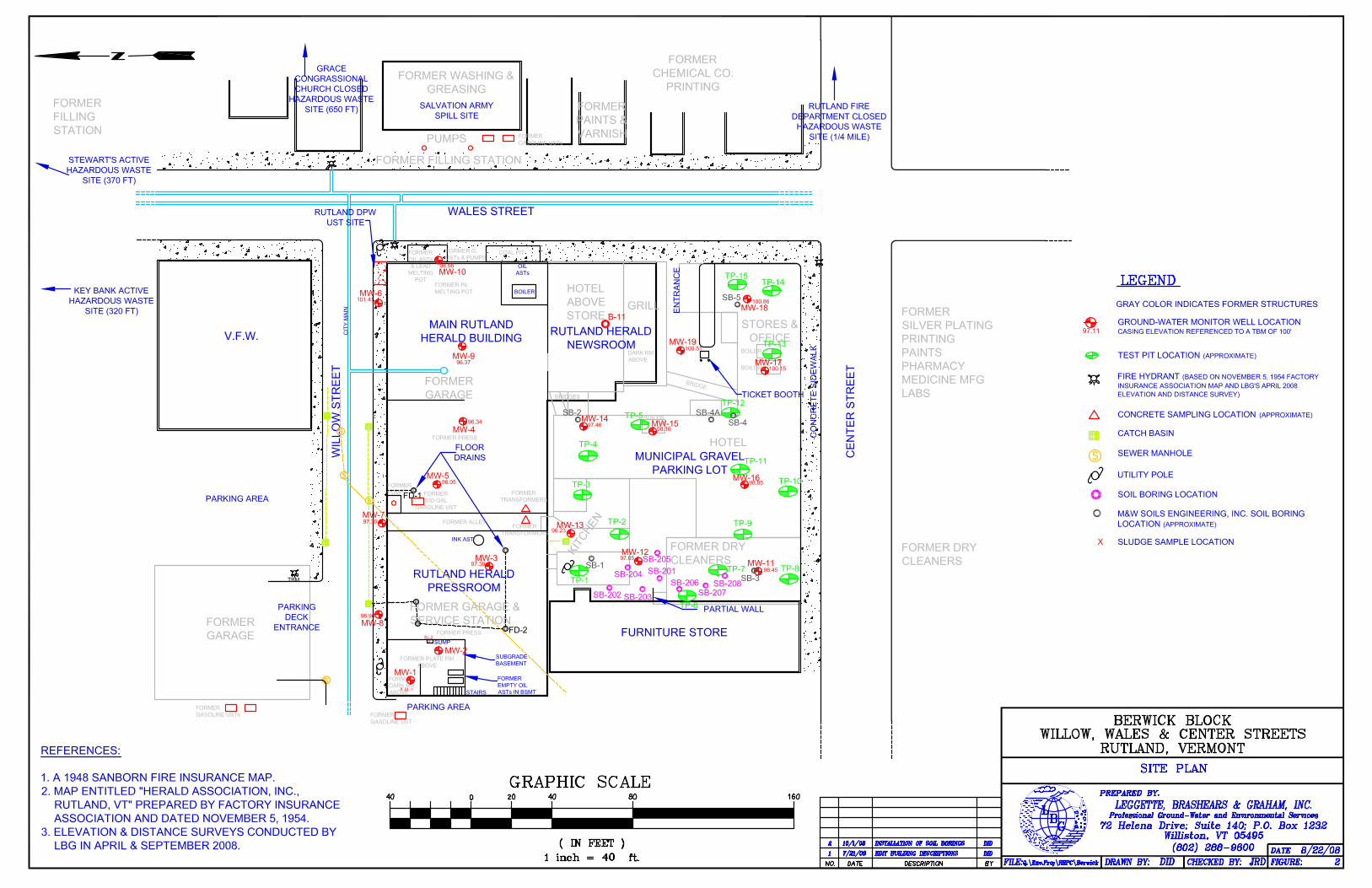
SITE PLAN
BERWICK BLOCK
FIGURE:CHECKED BY:
PREPARED BY:
RUTLAND, VERMONT
LEGGETTE, BRASHEARS & GRAHAM, INC.Professional Ground-Water and Environmental Services
72 Helena Drive; Suite 140; P.O. Box 1232
Williston, VT 05495
(802) 288-9600
FILE: DRAWN BY:Q:\Env.Proj\RRPC\Berwick DID
L
GB
DATE: 8/22/082JRD
WILLOW, WALES & CENTER STREETS
NO. DATE DESCRIPTION BY1 inch = ft.
( IN FEET )
GRAPHIC SCALE0
REFERENCES:
1. A 1948 SANBORN FIRE INSURANCE MAP.
2. MAP ENTITLED "HERALD ASSOCIATION, INC.,
RUTLAND, VT" PREPARED BY FACTORY INSURANCE
ASSOCIATION AND DATED NOVEMBER 5, 1954.3. ELEVATION & DISTANCE SURVEYS CONDUCTED BY
LBG IN APRIL & SEPTEMBER 2008.
LEGEND
GRAY COLOR INDICATES FORMER STRUCTURES
93.20
GROUNDWATER MONITOR WELL
FENCE LINE
WELL CASING ELEVATION IN FEET
TANK LEGEND
1
30,000 GALLON FUEL OIL TANK
12,000 GALLON DIESEL TANK
10,000 GALLON KEROSENE TANK2
3
4
5
6
7
25,000 GALLON FUEL OIL TANK
550 GALLON FUEL OIL TANK
275 GALLON FUEL OIL TANK
PROPANE TANK
20 160
40
804040
GROUND-WATER MONITOR WELL LOCATION
CASING ELEVATION REFERENCED TO A TBM OF 100'
TEST PIT LOCATION (APPROXIMATE)
D
YH
FIRE HYDRANT (BASED ON NOVEMBER 5, 1954 FACTORYINSURANCE ASSOCIATION MAP AND LBG'S APRIL 2008
ELEVATION AND DISTANCE SURVEY)
CONCRETE SAMPLING LOCATION (APPROXIMATE)
PROPOSED (2" INCH DIAMETER) GROUND-WATERMONITOR WELL LOCATION (MAY BE SUBJECT TOCHANGE BASED ON LAND OWNER PERMISSION & UTILITY
CLEARANCE)
PROPOSED GEOPROBE® (1" DIAMETER)GROUND-WATER MONITOR WELL LOCATION (MAYBE SUBJECT TO CHANGE BASED ON LAND OWNER PERMISSION
& UTILITY CLEARANCE)
PROPOSED TEST PIT LOCATION (MAY BE SUBJECT TO
CHANGE BASED ON UTILITY CLEARANCE)
D
YH
APPROXIMATE LOCATION OF HYDRANT (BASED ON
NOVEMBER 5, 1954 FACTORY INSURANCE ASSOCIATION MAP)
PROPOSED CONCRETE SAMPLING LOCATION
S
CATCH BASIN
SEWER MANHOLE
UTILITY POLE
97.11
1 7/21/08 EDIT BUILDING DESCRIPTIONS DID
SOIL BORING LOCATION
2 10/1/08 INSTALLATION OF SOIL BORINGS DID
M&W SOILS ENGINEERING, INC. SOIL BORINGLOCATION (APPROXIMATE)
SLUDGE SAMPLE LOCATIONX
FORMER
GARAGE
FORMER GARAGE &
SERVICE STATION
FORMER DRY
CLEANERS
FURNITURE STORE
KITCHEN
HOTEL
STORES &
OFFICE
HOTEL
ABOVE
STOREGRILL
FORMER
GARAGE
FORMER WASHING &
GREASING
FORMER FILLING STATION
PUMPS
WALES STREET
WILLOW
STREET
CENTER
STREET
COAL PIT
BOILER
FORMER
OIL ASTs
& LEAD
MELTING
POT
BRIDGE
BRIDGES
FORMER
500-GAL
GASOLINE UST
FORMER
PUMP
CITY
MA
IN
BOILER
BOILER
BOILER
OIL
ASTs
FORMER
TRANSFORMERS
FORMER
TRANSFORMERS
FORMER Pb
MELTING POT
FORMER PRESS
FORMER
DARK RM
ABOVE
FORMER PLATE RM
ABOVE
FORMER
EMPTY OIL
ASTs IN BSMT
FORMER
GASOLINE UST
FORMER
GASOLINE USTs
FORMER G.
USTs & PUMPS
RUTLAND HERALD
NEWSROOM
MAIN RUTLAND
HERALD BUILDING
RUTLAND HERALD
PRESSROOM
MUNICIPAL GRAVEL
PARKING LOT
INK AST
FORMER PRESS
FORMER
GASOLINE USTs
FORMER
PAINTS &
VARNISH
FORMER DRY
CLEANERS
FORMER
SILVER PLATING
PRINTING
PAINTS
PHARMACY
MEDICINE MFG
LABS
FORMER
CHEMICAL CO.
PRINTING
FORMER
FILLING
STATION
V.F.W.
FLOOR
DRAINS
D
YH
D
YH
SALVATION ARMY
SPILL SITE
RUTLAND FIRE
DEPARTMENT CLOSED
HAZARDOUS WASTE
SITE (1/4 MILE)
GRACE
CONGRASSIONAL
CHURCH CLOSED
HAZARDOUS WASTE
SITE (650 FT)
DARK RM
ABOVE
RUTLAND DPW
UST SITE
STEWART'S ACTIVE
HAZARDOUS WASTE
SITE (370 FT)
KEY BANK ACTIVE
HAZARDOUS WASTE
SITE (320 FT)
D
YH
D
YH
S
S
S
S
MW-18
MW-17
MW-19
MW-15MW-14
MW-16
MW-13
MW-12
MW-11MW-3
MW-1
MW-2
MW-7
MW-8
MW-5
MW-4
MW-9
MW-6
MW-1098.56
101.41
96.37
96.3497.46
96.05
97.30
97.39
96.23
97.05
96.96
98.45
98.85
98.16
100.15
100.51
100.86
D
D
D
D
D
PARKING
DECK
ENTRANCE
PARKING AREA
PARKING AREA
PARTIAL WALL
TP-1
TP-2
TP-3
TP-4
TP-5
TP-6
TP-7 TP-8
TP-9
TP-10
TP-11
TP-12
TP-13
TP-14TP-15
TICKET BOOTH
ENTRANCE
CONCRETE
SIDEWALK
FD-1
FD-2
TBM
SUMP
B-11
STAIRS
SUBGRADE
BASEMENT
FORMER ALLEY
SB-208
SB-207
SB-206
SB-203
SB-201
SB-205
SB-204
SB-202
97.51
95.39
95.65
92.9993.56
93.02
92.21
92.05
92.30
95.71
94.24
94.39
92.55
92.19
91.59
91.50
91.52
92'
93'
94'
95'
96'
97'
SB-3
SB-1
SB-2 SB-4A
SB-4
SB-5
X SL-1
X
SL-2

GROUND-WATER CONTOUR PLAN
BERWICK BLOCK
FIGURE:CHECKED BY:
PREPARED BY:
RUTLAND, VERMONT
LEGGETTE, BRASHEARS & GRAHAM, INC.Professional Ground-Water and Environmental Services
72 Helena Drive; Suite 140; P.O. Box 1232
Williston, VT 05495
(802) 288-9600
FILE: DRAWN BY:Q:\Env.Proj\RRPC\Berwick DID
L
GB
DATE: 10/13/083JRD
WILLOW, WALES & CENTER STREETS
1 inch = ft.
( IN FEET )
GRAPHIC SCALE0
REFERENCES:
1. A 1948 SANBORN FIRE INSURANCE MAP.
2. MAP ENTITLED "HERALD ASSOCIATION, INC.,
RUTLAND, VT" PREPARED BY FACTORY INSURANCE
ASSOCIATION AND DATED NOVEMBER 5, 1954.3. AN ELEVATION & DISTANCE SURVEY CONDUCTED BY
LBG IN APRIL 2008.
LEGEND
GRAY COLOR INDICATES FORMER STRUCTURES
GROUND-WATER MONITOR WELL LOCATION
TEST PIT LOCATION (APPROXIMATE)
D
YH
FIRE HYDRANT (BASED ON NOVEMBER 5, 1954 FACTORYINSURANCE ASSOCIATION MAP AND LBG'S APRIL 2008
ELEVATION AND DISTANCE SURVEY)
CONCRETE SAMPLING LOCATION (APPROXIMATE)
S
CATCH BASIN
SEWER MANHOLE
UTILITY POLE
40 40 80
40
16020
GROUND-WATER ELEVATION (in units of feet)
GROUND-WATER CONTOUR LINE
GROUND-WATER FLOW DIRECTION
94.68
94'
SEPTEMBER 17-18, 2008
SOIL BORING LOCATION
M&W SOILS ENGINEERING, INC. SOIL BORINGLOCATION (APPROXIMATE)
SLUDGE SAMPLE LOCATIONX
FORMER
GARAGE
FORMER GARAGE &
SERVICE STATION
FORMER DRY
CLEANERS
FURNITURE STORE
KITCHEN
HOTEL
STORES &
OFFICE
HOTEL
ABOVE
STOREGRILL
FORMER
GARAGE
FORMER WASHING &
GREASING
FORMER FILLING STATION
PUMPS
WALES STREET
WILLOW
STREET
CENTER
STREET
COAL PIT
BOILER
FORMER
OIL ASTs
& LEAD
MELTING
POT
BRIDGE
BRIDGES
FORMER
500-GAL
GASOLINE UST
FORMER
PUMP
CITY
MA
IN
BOILER
BOILER
BOILER
OIL
ASTs
FORMER
TRANSFORMERS
FORMER
TRANSFORMERS
FORMER Pb
MELTING POT
FORMER PRESS
FORMER
DARK RM
ABOVE
FORMER PLATE RM
ABOVE
FORMER
EMPTY OIL
ASTs IN BSMT
FORMER
GASOLINE UST
FORMER
GASOLINE USTs
FORMER G.
USTs & PUMPS
RUTLAND HERALD
NEWSROOM
MAIN RUTLAND
HERALD BUILDING
RUTLAND HERALD
PRESSROOM
MUNICIPAL GRAVEL
PARKING LOT
INK AST
FORMER PRESS
FORMER
GASOLINE USTs
FORMER
PAINTS &
VARNISH
FORMER DRY
CLEANERS
FORMER
SILVER PLATING
PRINTING
PAINTS
PHARMACY
MEDICINE MFG
LABS
FORMER
CHEMICAL CO.
PRINTING
FORMER
FILLING
STATION
V.F.W.
FLOOR
DRAINS
D
YH
D
YH
SALVATION ARMY
SPILL SITE
RUTLAND FIRE
DEPARTMENT CLOSED
HAZARDOUS WASTE
SITE (1/4 MILE)
GRACE
CONGRASSIONAL
CHURCH CLOSED
HAZARDOUS WASTE
SITE (650 FT)
DARK RM
ABOVE
RUTLAND DPW
UST SITE
STEWART'S ACTIVE
HAZARDOUS WASTE
SITE (370 FT)
KEY BANK ACTIVE
HAZARDOUS WASTE
SITE (320 FT)
D
YH
D
YH
S
S
S
S
MW-18
MW-17
MW-19
MW-15MW-14
MW-16
MW-13
MW-12
MW-11MW-3
MW-1
MW-2
MW-7
MW-8
MW-5
MW-4
MW-9
MW-6
MW-1098.56
101.41
96.37
96.3497.46
96.05
97.30
97.39
96.23
97.05
96.96
98.45
98.85
98.16
100.15
100.51
100.86
D
D
D
D
D
PARKING
DECK
ENTRANCE
PARKING AREA
PARKING AREA
PARTIAL WALL
TP-1
TP-2
TP-3
TP-4
TP-5
TP-6
TP-7 TP-8
TP-9
TP-10
TP-11
TP-12
TP-13
TP-14TP-15
TICKET BOOTH
ENTRANCE
CONCRETE
SIDEWALK
FD-1
FD-2
TBM
SUMP
B-11
STAIRS
SUBGRADE
BASEMENT
FORMER ALLEY
SB-208
SB-207
SB-206
SB-203
SB-201
SB-205
SB-204
SB-202
97.51
95.39
95.65
92.9993.56
93.02
92.21
92.05
92.30
95.71
94.24
94.39
92.55
92.19
91.59
91.50
91.52
92'
93'
94'
95'
96'
97'
SB-3
SB-1
SB-2 SB-4A
SB-4
SB-5
X SL-1
X
SL-2


![Selbständig in Mode und Lifestyle - MARGIT TETZ ... · Gefühl, ich muss fünf Leute gleichzeitig anrufen, r ... qr1 lddeqaS lqrru sep ]Er-{ aur,rpua8rr ßqe"'pueql-pr lr< rRpc'](https://static.fdocuments.net/doc/165x107/5aecc0527f8b9a36698ff546/selbstndig-in-mode-und-lifestyle-margit-tetz-ich-muss-fnf-leute-gleichzeitig.jpg)


![15- eSa Hkh--- - Prashanth Ellinacbsebooks.prashanthellina.com/class_1.Hindi.Rimjhim/15...89 15- eSa Hkh---,d vaMs esa ls cÙk[k dk cPpk fudykA yks] eSa vaMs esa ls fudy vk;k cÙk[k](https://static.fdocuments.net/doc/165x107/5e5bab81c430bc02a910381c/15-esa-hkh-prashanth-89-15-esa-hkh-d-vams-esa-ls-ckk-dk-cppk-fudyka.jpg)