Applications for smart secondary substations based on selected pilot ...

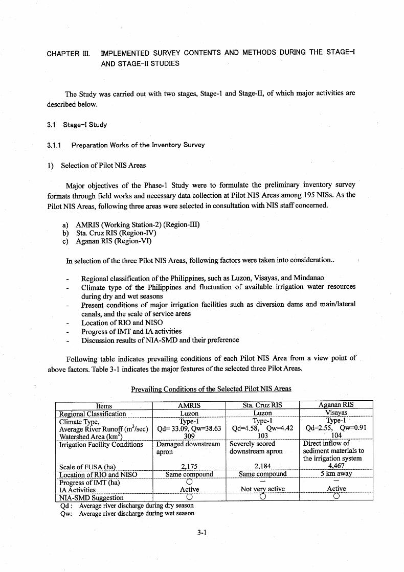

Table 3-1 Major Features of the Selected Three Pilot NIS Areas for the Inventory Survey
Items AMRIS (Working Station: II) Sta. Cruz RIS Aganan RIS
1. Location 1.1 Region III (Bulacan), Tambubong、San
Rafael, Bulacan IV (Laguna), Region IV、Pila、Laguna
VI (Iloilo), Tacas Jaro, Iloilo City
1.2 Climate Type (Annual Rainfall) Type-1 2,674 mm (1961-1982)
Type-1 1,861 mm (1961-1986)
Type-1 1,686 mm (1958-1983)
2. Irrigation System 2.1 Official Opening of System 1925 1958 1925 2.2 Improvement History of Main
Facilities Improved by Japan Grant Aid Program (1998)
No Improved Improved by Japan Grant Aid Program (1998)
3. Present Main Facility Conditions 1/ 3.1 Diversion Dam Well-Managed Severely Damaged Poorly-Maintained 3.2 Main & Lateral Canal Normally-Maintained Normally-Maintained Normally-Maintained
4. Irrigation Water Resource 4.1 River Name Angat River Sta. Cruz River Aganan River 4.2 Water Resources Bustos Diversion Dam (Rubber) Sta. Cruz Diversion Dam (Ogee) Agana Diversion Dam (Ogee)
5. Irrigation Service Area and Main Crop
5.1 Designed Service Area Area of Working Station II: 2,231 ha (31,485 ha) 2/
4,133 ha 5,500 ha
5.2 Firmed-up Service Area 2,175 ha (26,791 ha) 2/ 2,184 ha 4,467 ha 5.3 Main Crops
Wet Season Dry Season
Paddy Paddy
Paddy Paddy
Paddy Paddy
5.4 Average Farm Size 1.6 ha/house hold 1.1 ha/house hold 2.0 ha/house hold
6. Irrigators Association 8 IA (95 IA) 2/ 4 IA 7 IA 1/ : Well-Managed : presenting in the ranges more than 80 percent of the original functionality
Poorly maintained : presenting in the ranges less than 50 percent of the original functionality Severely damaged : presenting serious situations of facilities with critical deterioration through loss of function 2/ : Figures in parentheses show the whole service areas in AMRIS.
3-2


3-14
Table 3-2 Comparison of Survey Items between Original and Modified Formats in Terms of General, Water Resources and Irrigation Water Requirements
Information Original Format Modified Format
I. General Information 13. Main Crops and Cropping Intensity 13. Main Crops
2.1 Available Water Resources (4) Annual Rainfall : Catchment Area
Service Area (5) Available Runoff Discharge Records at Div. Site (6) Average Runoff Discharge at Diversion Site (7) Average Diverted Discharge (Actual Observation Records)
2.1 Available Water Resources (4) Average River Discharge at Diversion Site (5) Average Diverted Intake Discharge (6) Total Rainfall : Service Area Drainage Area
2.2 Irrigation Water Requirement (IWR) (4) Irrigation Parameters for LS/LP Soil Type Soil Saturation (Sn) Percolation (P) Evaporation (E) Evapo-Transpiration (Et) (5) Average Monthly Irrigation Water Requirement (IWR) Losses (Farm Waste and Delivery Loss) Losses (Canal Conveyance Loss) Effective Rainfall
(6) Max. Monthly Irrigation Water Requirement (7) Max. Unit Irrigation Water Requirement (8) Designed Irrigation Water Requirement (9) Area and Percentage of Water Shortage (10) Location of Water Shortage Occurrence in Dry Season (11) Damaged Amounts by Water Shortage (12) Reasons of Water Shortage (13) Utilization Conditions of Return Flow (Re-Use)
2.2 Irrigation Water Requirement (IWR) (4) Irrigation Parameters for LS/LP Soil Type Percolation (P) Evaporation (Et) Evapo-Transpiration (Et) (5) Average Monthly Irrigation Water Requirement (IWR) 1/ Crop Water Requirement (CWR) (W/O Effe. Rainfall) Turn-out Water Duty (qtni) (W/O Effective Rainfall) Irrigation Diversion Requirement (IDR)
1/ derived from newly formulated “Operation and Maintenance Plan”,, and Summary Table of water Resources and Irrigation Requirement was eliminated.
(6) Max. Unit Land Soaking Irrigation Requirement (qtsi) (7) Location and Percentage of Water Shortage
(8) Location of Water Shortage Occurrence in Dry Season (9) Damaged Amounts by Water Shortage (10) Reasons of Water Shortage (11) Utilization Conditions of Return Flow (Re-Use)
2.3 Farm Management Conditions (1) Present Cropping Pattern
2.3 Farm Management Conditions (1) Present Cropping Pattern and Irrigated Area
II. Water Resources and Irrigation Requirement Information
2.4 Balance of Available Water Resources and Irrigation Water Requirement in Average Year and CY
Average River Runoff Discharge (ARRD) (1/2) Average River Runoff Discharge (ARRD) (1/3) Average Diverted Intake Discharge (ADID) Irrigation Water Requirement in CY (IWR)
2.4 Balance of Available Water Resources and Irrigation Water Requirement in Average Year
Average River Discharge (RD) Average Diverted Intake Discharge (DID) Average Irrigation Diversion Requirement (IDR) 1/
1/ : derived from “Operation and Maintenance Plan”
III. Flood and Drainage Information
3.1 Flood Information (3) Past 10-Year Peak Flood Discharge, Daily Rainfall and Date at Diversion Dam Site
3.1 Flood Information (3) Peak Flood Discharge for Past 10-Year
Attached Data Table-1 Monthly Rainfall Records (in Drainage Area/ Diversion Dam Site) (mm/month)
Table-2 Monthly Rainfall Records (near Service Area) (mm/month)
Table-3 Monthly Effective Rainfall (mm/month) Table-4 Monthly Average Discharge Records (at Diversion
Site) (m3/sec) Table-5 Monthly Average Discharge Records (at Adjacent Station on Other Drainage Area Table-6 Monthly Average Intake Discharge Records
(m3/sec) Table-7 Irrigated and Benefited Areas (ha)
Table 2-1 Monthly Average River Discharge Records (at Diversion Site) (m3/sec)
Table 2-2 Monthly Average River Discharge Records (m3/sec) (at Adjacent Station in Other Drainage
Area) (Tabulated in Case Data in Table 2-1 are not Available)
Table 2-3 Monthly Average Diverted Intake Discharge Records (lit/sec)
Table 2-4 Monthly Rainfall Records (near Service Area) (mm/month) Table 2-5 Monthly rainfall Records (in Drainage Area/ Diversion Site) (tabulated in Case Data in Table 2-4
are not Available) (mm/month) Table 2-6 Firm-up Service Area, Program Areas, Irrigated and Benefited Areas Figure 2-1 Typical Cropping Pattern of Paddy The data in Table 2-1 to Table 2-6 are made up by seasons (dry, wet and annual)


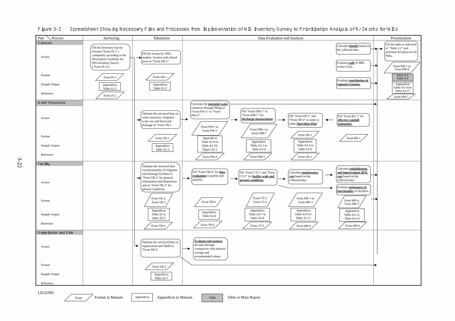
Figure 3-2 Spreadsheet Showing Necessary Files and Processes from Implementation of NIS Inventory Survey to Prioritization Analysis of R/I Works for NISs
Part Process Surveying Tabulation Prioritization Common
Action
Format
Sample Output
Reference
Water Resources
Action
Format
Sample Output
Reference
Facility
Action
Format
Sample Output
Reference
Organization and O&M
Action
Format
Sample Output
Reference LEGEND:
Format in Manual, Appendices in Manual, Table in Main Report
Data Evaluation and Analysis
Fill the Inventory Survey Format ("Form IS-1") completely according to the Description Guideline for NIS Inventory Survey ("Form IS-2").
Form IS-1
Form IS-2
Appendices Table A2-1
Fill the format for NISs number, location and related areas in "Form AR-1".
Form AR-1
Appendices Table A2-2
Tabulate the surveyed data on functionality of irrigation and drainage facilities in "Form TB-2" for general information and dimensions and in "Form TB-3" for present conditions
Calculate the potential waterresources through filling of “Form PW-1” to “Form PW-3”.
Fill the table as indicated in “Table 3-1” and prioritize R/I plans for all NISs.
Table 4-5,Table 4-6
Calculate benefit based on the collected data.
Evaluate contribution of regional economy.
Evaluate scale of MRI works (cost).
Tabulate the surveyed data on water resources, irrigation water use and flood and drainage in "Form TB-1
Form TB-1
Appendices Table A2-3
Form PW-1 to Form PW-3
Appendices Table A2-8 to Table A2-10, Figure A2-1
Fill “Form DM-1” to “Form DM-7” for discharge measurement.
Form DM-1 to Form DM-7
Appendices Table A3-1 to
Table A3-4
Fill “Form OP-1” and “Form OP-2” in order to make Operation Plan.
Appendices Table A3-5 to
Table A3-6
Fill “Form RE-1” for effective rainfall estimation.
Form RE-1 Form OP-1
Form OP-2Form DM-5Form PW-4
Form TB-2, Form TB-3
Form TB-6
Appendices Table A2-4, Table A2-5
Fill “Form TB-4” for data evaluation in quality and quantity
Form TB-4
Appendices Table A2-6
Fill “Form CT-1” and “Form CT-2” for facility scale and present conditions.
Appendices Table A3-7 to
Table A3-8
Calculate maintenance cost based on the collected data.
Calculate rehabilitation and improvement (R/I) cost based on the collected data.
Evaluate seriousness of functionality of facilities.
Tabulate the surveyed data on organization and O&M in "Form TB-5"
Form TB-5
Appendices Table A2-7
Evaluate and analyze the data through comparison with national average and recommended values.
Form PM-1 toForm PM-6
Form PM-7
Form TB-6 Form CT-3
Form CT-1,Form CT-2
Form MP-1 toForm MP-3
Appendices Table A3-9 to Table A3-11
Form MP-6
Form MP-4, Form MP-5
Appendices Table A3-12, Table A3-13
Form MP-6
Form Appendices Table
3-22
Appendices Table A3-14 to
Table A3-17

Figure 3-3 Flow Diagram of Data Compilation of Inventory Survey and Report Submission Procedures
Res
pons
ible
O
ffic
e/St
aff
Task
Month
Off
ice A
ctiv
ities
In
vent
ory
Surv
ey W
orks
and
Res
pons
ible
Sta
ff
April May October November December
No water supply in canals during the period of April and May, after dry season Paddy harvest, and easily observation of prevailing irrigation and drainage facilities
NIS
- Water Master - Gate Keeper
- Field survey, data/information collection for Inventory Survey
Not yet start ofirrigation service fee (ISF) collection
RC(NISO)
- Assistant Irrigation Superintendent (Asst. IS)
- Data compilation, tabulation and checking
Taking a short breath after typhoon season and before starting harvesting of wet season paddy
RC (NISO), RO - Irrigation
Superintendent (IS) - Regional O&M
Engineer
- Evaluation ofcompiled data, and identification of problems to be improved.
- Preparation of maintenance, rehabilitation and improvement (MRI) plans
Preparation stage of preliminary Regional Program of Works (POW)
RO - Regional Irrigation
Manager
- Prioritization analysis among MRI plans - Effective
utilization for final preparation of Regional Program of Works (POW)
Central Office
NIA-SMD
- Integration and Management of Master File of Inventory Survey
3-23