T.A. Bale/ & P. Holmes^ Abstractdevelopments case study 2: Al Khiran Pearl City, Kuwait T.A. Bale/ &...
12
Lagoon residential and recreational developments case study 2: Al Khiran Pearl City, Kuwait T.A. Bale/ & P. Holmes^ *Buro Happold Consulting Engineers, Camden Mill, Lower Bristol Road, Bath, UK 2Imperial College of Science, Technology and Medicine, Exhibition Road, London, UK Abstract Feasibility studies for sea city development on fifteen potential sites along the Kuwait coastline were carried out from 1987 to 1989. The conclusion of these studies was that six sites were suitable for major development of waterside cities, involving large scale excavation, dredging and reclamation works. A paper by Ealey, Holmes and Clark, which described the feasibility studies, was presented to the International Conference on Marinas at Southampton in 1989. Work commenced on planningand environmental impact assessment forone of the six sites, at Shuwaikh in Kuwait City. This work was halted by the invasion of Kuwait in 1990. After the liberation of Kuwait, the authorities in Kuwait were reluctant to sanction the development at Shuwaikh, but Council of Ministers approval was obtained for four of the sites, one being atAl Khiran. Work was commenced on a Master Plan for the Al Khiran site in 1994, but this was stopped later that year, due to lack of favourable support from the Authorities. Work commenced again on planning in 1997, and a new Master Plan was prepared. This new Master Plan has been presented to the Municipal Authorities forapproval. Site location The site for the Al Khiran Pearl City development is adjacent to the Arabian Gulf coastline, some 85km south of Kuwait City, at N 28° 39'E 48' 23'. It is some 13km north of the border with Saudi Arabia. The site is situated to the south of the Ras Al Zawr promontory and lies immediately to the west of the existing Khiran Resort and extends over an area of approximately 6400 hectares. Transactions on the Built Environment vol 40 © 1999 WIT Press, www.witpress.com, ISSN 1743-3509
Transcript of T.A. Bale/ & P. Holmes^ Abstractdevelopments case study 2: Al Khiran Pearl City, Kuwait T.A. Bale/ &...

Lagoon residential and recreational
developments case study 2:
Al Khiran Pearl City, Kuwait
T.A. Bale/ & P. Holmes^
*Buro Happold Consulting Engineers, Camden Mill,
Lower Bristol Road, Bath, UK
2Imperial College of Science, Technology and Medicine,
Exhibition Road, London, UK
Abstract
Feasibility studies for sea city development on fifteen potential sites along theKuwait coastline were carried out from 1987 to 1989. The conclusion of thesestudies was that six sites were suitable for major development of waterside cities,involving large scale excavation, dredging and reclamation works. A paper byEaley, Holmes and Clark, which described the feasibility studies, was presentedto the International Conference on Marinas at Southampton in 1989.
Work commenced on planning and environmental impact assessment for oneof the six sites, at Shuwaikh in Kuwait City. This work was halted by theinvasion of Kuwait in 1990. After the liberation of Kuwait, the authorities inKuwait were reluctant to sanction the development at Shuwaikh, but Council ofMinisters approval was obtained for four of the sites, one being at Al Khiran.
Work was commenced on a Master Plan for the Al Khiran site in 1994, butthis was stopped later that year, due to lack of favourable support from theAuthorities. Work commenced again on planning in 1997, and a new MasterPlan was prepared. This new Master Plan has been presented to the MunicipalAuthorities for approval.
Site location
The site for the Al Khiran Pearl City development is adjacent to the Arabian Gulfcoastline, some 85km south of Kuwait City, at N 28° 39' E 48' 23'. It is some13km north of the border with Saudi Arabia. The site is situated to the south ofthe Ras Al Zawr promontory and lies immediately to the west of the existingKhiran Resort and extends over an area of approximately 6400 hectares.
Transactions on the Built Environment vol 40 © 1999 WIT Press, www.witpress.com, ISSN 1743-3509

636 Coastal Engineering and Marina Developments
Figure 1. The Site
The existing site contains two shallow creeks. One lies to the north of KhiranResort (Khor Al A'ma), running some 4.5 km in a north-westerly direction, andthe other (Khor Al Mufatteh) to the south of Khiran Resort. The creeks havegenerally shallow water depths, increasing to approximately 4m below datum attheir entrances.
The site terrain is very gently undulating and generally sandy. A number ofweak rock ridges and outcrops are in evidence. In particular, there is a rockyridge running down the coast and a series of outcropping ridges approximately1.5km inland from the coastline.
Existing development and infrastructure
Al Khiran has been a popular recreation destination for several years.The Al Khiran Resort provides a highly popular weekend and holiday
destination, which is often fully booked.Private chalets have been built in a speculative and unplanned way along the
existing shoreline and along the edges of the creeks. This has restricted publicaccess to the coast, altered the natural environment, and placed considerabledemands on the infrastructure.
The Mina Azzour Power Plant is to the north of the site, located on the coast.A series of high voltage power lines radiate from it and their alignment has to besafeguarded, or the lines may in places be rerouted.
Transactions on the Built Environment vol 40 © 1999 WIT Press, www.witpress.com, ISSN 1743-3509

Coastal Engineering and Marina Developments 637
The main north/south motorway is located just to the west of the siteboundary and forms the main route between Kuwait City and the border withSaudi Arabia. An existing road leads from the motorway to the Al Khiran resort,and three single carriageway roads access the coastal chalets. There are severalother tracks and telephone lines crossing the site, and their alignment will eitherhave to be safeguarded or altered.
Existing oil and gas facilities and concessions are to be found adjacent to thesite.
Much of the existing coastal fringe is already developed and in private lease-hold ownership. The rights of existing owners and their access to the sea haveto be respected. The master plan has therefore to accommodate existingdevelopment and integrate it into the proposed new infrastructure and development.
Development requirements
Planning Objectives
Al Khiran Pearl City is anticipated to have a population in excess of 100,000when it is completed.
The primary objective is to develop Al Khiran Pearl City as a unique andattractive water-based development that encompasses local cultural traditions;tempers the harsh environment with good quality construction, landscaping andrecreation facilities; and sets a high standard for waterside development in theMiddle East.
The principal asset of the site is the opportunity to form large bodies of waterfrom fairly flat and featureless sabkha, and to use excavated material to alter thesite topography. This should be exploited to the full to maximise water accessand to add interest to the site.
The development should have a positive impact on the ecosystem of the area.Marine and bird life will be encouraged to flourish through careful water
management and improved ground cover from extensive and varied landscaping.The development will be large and it will be essential to make it a unique and
interesting City with a strong sense of place. This should be achieved byimaginative configuration of the water area, and by an overall design conceptwhich has sufficient flexibility for adaptation and change. Extensive landscapingwill be used to ameliorate the harsh environment and to give unity and identityto residential areas.
To enhance the attractions of the development a full range of facilities,including leisure and recreation, will be provided so that a self-containedcommunity can thrive and flourish.
The layout of water areas should maximise water frontage for residentialdevelopment. This is achieved by use of bays, inlets and islands.
The master plan should provide a variety and interest to the configuration ofwater areas that is compatible with site topography and prevailing wind and tidalflows. The design of the water area should take advantage of wind direction and
Transactions on the Built Environment vol 40 © 1999 WIT Press, www.witpress.com, ISSN 1743-3509
638 Coastal Engineering and Marina Developments
tidal flows to drive the exchange of water through the network of channels toensure water replenishment and avoid water stagnation.
Existing coastal development and infrastructure should be integrated with theproposed development.
Marinas should be located near to the coast to facilitate navigation. Anextensive network of navigation channels is proposed and, in order to facilitateaccess for larger craft, marinas should be located on the main channels near tocoastal access. Location of commercial plots around marinas will enable themto be more easily identified from the water.
Bridges between islands should be carefully positioned so that navigation isnot restricted. Bridges high enough to permit navigation of high masted craft areexpensive to construct, are intrusive to the environment, and should not be locatedover main navigation channels.
Community facilities should be located where they will be easily accessibleto all residents.
Public beaches should be provided for those without direct access to the water.Private courtyards with recreation facilities should be allocated for those plotsthat are not close to the shore.
The use of excavated and dredged material for ground modeling should be apriority from the start of development, together with the establishment ofstructure landscaping.
Landscape Strategy
The site has a bleak setting on the edge of the desert and needs to be visuallyscreened to give an oasis of calm tranquillity from its harsh surroundings.
The site should be sheltered from the strong dust carrying winds to improvethe microclimate.
Landscape within the development should be used to provide visual interestand identity and to give a distinctive character to different neighbourhoods.
Good quality materials should be used for both hard and soft landscaping.
Employment
In the very early stages of development most people will be temporary residentsvisiting the city at weekends and holidays, with employment in other parts of thecountry. However, as the city grows and attracts a more permanent population,the range of employment opportunities is also likely to increase.
Initially employment will focus on service jobs in retailing, leisure, catering,development maintenance and domestic service. As the city matures, opportunitiesfor employment in education and health will also increase. It is unlikely thatindustrial or government employment will be significant. It is very likely,however, that Al Khiran Pearl City will provide first homes for a number ofpeople employed in the oil and petroleum sector.
Transactions on the Built Environment vol 40 © 1999 WIT Press, www.witpress.com, ISSN 1743-3509

Coastal Engineering and Marina Developments 639
Phasing
The design layout should be structured so that each phase constitutes an integratedwhole and is not dependent on later phases for its viability.
Existing wind and hydrodynamic environment
Winds
The wind rose for Kuwait Airport is shown in figure 2. It is drawn frommeteorological records from May 1986 to April 1997. During this period thereis a gap in the records corresponding to the invasion and occupation of Kuwait,and the data therefore covers an aggregate total of 10 years records.
The winds in the northern part of the Arabian Gulf are predominantly north-westerly and are referred to locally as 'Shamal'. Due to the fact that the generalpattern of barometric pressure is similar both in summer and winter, the Shamalpersists throughout the year. Thus winds from the northwest quadrant occur forsome 43% of the time. There are, however, slight variations in the direction ofthe Shamal according to season, and winds frequently blow from the northquadrant, occurring for some 16% of the time. Southeasterly and southerlywinds are generally associated with the short spring and autumn seasons (Marchto April and October to November) and occur for about 22% of the time. Windsfrom the southwest quadrant are generally of low intensity, and blow in anoffshore direction.
NW
NE
SW SE
Figure 2. Wind Rose
Transactions on the Built Environment vol 40 © 1999 WIT Press, www.witpress.com, ISSN 1743-3509
640 Coastal Engineering and Marina Developments
Tides
The tides within the Arabian Gulf are complex, ranging from semi-diurnalthrough 'mixed' to diurnal. The tidal range reduces from north to south along theKuwait coastline. In Kuwait Bay the tides are semi-diurnal with the range beingas high as 4.2m during spring tides and as low as 0.5m during neaps. Furthersouth, near Mina Shuaiba, the tides are mixed, with a maximum range of about3.1m. At the coastline at Khiran the tides are mixed with substantial semi-diurnalinequality, with a mean tidal range of about 1.6m, and about 2.2m at springs.
Currents
The currents in the Arabian Gulf are as complex as the tides. The high evaporation,low rainfall, and low water inflow from rivers leads to a circulation pattern thatis typical for marginal seas in arid zones. Temperature cross sections in theStraits of Hormuz have indicated that cold water enters the Gulf on the north-eastern side and warm water leaves the Gulf on the southwestern side. It isthought that there is a major anti-clockwise circulation system in the Gulf, whichincludes weak southwesterly flow over the Arabian shallow shelf.The importance of wind effects on the current circulation pattern is not certain,but local wind effects can modify tide driven currents
Adjacent to the Arabian Gulf coast of Kuwait the currents are generallyparallel to the coastline. Data from studies at Shuaiba power station indicatethat tidal currents off Mina Shuaiba are generally less than 0.5m/s. This samedata indicated a net southerly drift of about 0.04m/s caused by the overallcirculation in the Gulf.
Waves incident to a coastline at an angle will generate an alongshore current,which for a beach will be significant to sediment transport, as such wave inducedcurrents will have higher velocities than both tidal and wind induced currents,particularly in very windy conditions. The sediment transport at the coastline atKhiran is predominantly in a north to south direction, which is indicated by thenatural coastline features.
Wave Conditions
Wave conditions on the strongly embayed coastline of Kuwait are variable,depending on the shoreline orientation and exposure. However, nowhere can thewave climate be considered to be severe. The dominant wave direction is fromthe northwest to northeast sector, as would be expected from the wind conditions,with wave heights less than 1m for 95% of the time, and with wave period 3 to5 seconds. Wave studies carried out by the Kuwait Institute for ScientificResearch for the oil loading facility at Ras Al Zawr indicated that offshoremaximum wave heights of 3m should be expected at least annually. The samestudy indicated an extreme wave height of 4m with a period of 8 seconds.
Winds acting on the fetch within the development will generate waveswithin the enclosed water bodies. Waves will also be generated by propeller andjet powered boats, and these waves can be sufficient to erode exposed beaches.
Transactions on the Built Environment vol 40 © 1999 WIT Press, www.witpress.com, ISSN 1743-3509
Coastal Engineering and Marina Developments 641
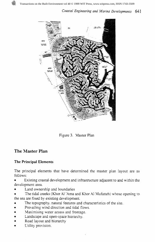
Figure 3. Master Plan
The Master Plan
The Principal Elements
The principal elements that have determined the master plan layout are asfollows:# Existing coastal development and infrastructure adjacent to and within thedevelopment area.* Land ownership and boundaries# The tidal creeks (Khor Al 'Ama and Khor Al Mufatteh) whose opening tothe sea are fixed by existing development.• The topography, natural features and characteristics of the site.# Prevailing wind direction and tidal flows.» Maximising water access and frontage.• Landscape and open-space hierarchy.• Road layout and hierarchy• Utility provision.
Transactions on the Built Environment vol 40 © 1999 WIT Press, www.witpress.com, ISSN 1743-3509

642 Coastal Engineering and Marina Developments
Existing Creeks
The site includes the existing creeks, which form key elements or constraints todevelopment of the master plan. Their existing alignments and openings to thesea have to be respected as they form part of the natural topographic evolutionof the site. In addition, the openings to the sea are fringed with existing chaletsin private ownership. In developing the master plan the creeks have retainedtheir significance and importance to the existing developments, as well as beingimportant to the new Al Khiran Pearl City.
Other Topographical and Natural Features
In preparing the master plan the 'natural grain' of the site has been followed interms of its natural features and characteristics. Though the site is generally flatand featureless sabkha, there are several rock outcrops and higher areas that havebeen retained because they are local landmarks and will form the basis of a morevaried and interesting landform. These include two prominent rock ridges to thesouth of the Khor Al MufTateh.
Along the western part of the site the land begins to rise and this will form anarea of hillside development using excavated material from dredging andexcavation of the water areas.
Prevailing Wind Direction and Tidal Flows
The prevailing wind direction and tidal flows have formed a major influence onthe way the master plan has evolved. The aim has been to work with the naturalforces of nature and the bays and inlets have been aligned to benefit from thetides and the prevailing direction of wind.
In developing such a large area of water it is essential that the water isreplenished by tidal and wind natural flushing processes, to facilitate waterexchange, and eliminate possible areas of stagnant water.
Maximising Water Access and Frontage
The clear aquamarine-coloured water of the Arabian Gulf is the main asset of thesite and provides an attraction and focus for the development. Experiencethroughout the world, and in other parts of the Middle East, has shown thatvillas with good water access and frontage are the most popular. In the generalwaterside area of the site it is planned that seventy percent of the villas will havea water frontage
The two existing creeks and two new channels link the three separate waterareas with the sea. It is intended to form an additional channel at the mostsoutherly end of the site to enhance tidal water exchange with the sea, if thisproves to be required by later detailed analysis of water flows. The areas ofwater have been configured with a series of bays and inlets and a network ofchannels, enabling a total of approximately 7,500 waterside plots to be built.
In preparing the master plan, bays and inlets have been formed in a varied
Transactions on the Built Environment vol 40 © 1999 WIT Press, www.witpress.com, ISSN 1743-3509

Coastal Engineering and Marina Developments 643
way to create a series of ever changing views and vistas. Privacy has beenmaintained by making the channels 125 to 200 metres wide.
The master plan has been designed so that it can be divided into discrete stagesof development and so that each phase of development will not be dependent onthe completion of later phases, which may not be built for twenty or thirty years.
Residential Areas
A residential hierarchy has been adopted to give coherence and structure to thedevelopment. A range of services and facilities will be provided that will forman important component of a well-planned resort.
The smallest neighbourhood unit is the KCU (Kindergarten Community Unit)which serves about 500 plots, or approximately 3750 people. A KCU includestwo local mosques, local shops, a kindergarten, public garden, and associated carparking.
The next level in the hierarchy of facilities is a PCU (Primary CommunityUnit) which comprises 3 KCU's and serves approximately 1,500 plots, orapproximately 11,000 people. Facilities comprise two primary and intermediateschools, public garden, shops and car parking. Seven PCU's are proposed in themaster plan.
An NCU (neighbourhood community unit) is provided for every two PCU'swith a comprehensive range of facilities, and will serve 3,000 plots, orapproximately 22,000 people. Intermediate and secondary schools are includedas well as a full range of shops, a clinic, major mosque and public garden. Otherfacilities include a gas station, bus terminal, main substations and telephoneexchange. Six NCU's are proposed in the master plan.
Land has been reserved for a city centre development on the western edge ofthe site. It will act as a link and focal point to Al Khiran New Town. It is likely tobe developed when both cities are well established with settled populations.
In the general waterside areas, a large proportion of internal plots, withoutdirect water access, have been grouped to focus on a community beach. Anumber of these community beaches have been provided along the shore line indifferent configurations so that everyone has water access, and an interesting andvaried water edge can be created.
Internal plots, which are not within easy reach of beach, have been groupedaround communal gardens, which could have a range of facilities such as tenniscourts and swimming pools.
Hillside plots have been located on higher ground to the west and south of thedevelopment where excess fill from dredging and excavation will be used toform a more varied topography. Linear areas of landscaping will be providedbetween plots to act as a foil to the built form.
In total 15,000 residential plots are proposed in the master plan, of which11,000 are in the waterside zones. The city centre would be further developedfor a range of commercial, commercial residential, shopping and recreationfacilities as the demand arises in the future.
Transactions on the Built Environment vol 40 © 1999 WIT Press, www.witpress.com, ISSN 1743-3509

644 Coastal Engineering and Marina Developments
Figure 4. Phasing of the Development
Two marinas have been provided, one at the north inlet, and the other at thesouth inlet. These marinas will be of 600-berth capacity.
Commercial plots have been located adjacent to marinas and large publicbeaches. These will also provide a range of apartments and hotel suites for thoserequiring rented or short stay accommodation. Higher buildings at theselocations will also provide interesting and varied focal points within thetownscape.
Phasing of the development
The Master Plan has been derived so that at the completion of each phase or partof phase, the development will not depend on any facilities, infrastructure andutilities to be installed in subsequent phases. This is most important, to ensurethat the community grows in a steady and organic manner.
There are four principal phases, each divided into a number of part phases.These are shown in the phasing plan in figure 4.
The first phase is divided into five parts, and represents the initial growth ofthe development based on the Khor Al Mufatteh and Khor Al 'Ama, and the new
Transactions on the Built Environment vol 40 © 1999 WIT Press, www.witpress.com, ISSN 1743-3509

Coastal Engineering and Marina Developments 645
north channel. At the completion of the first phase, the development will havegrown to a substantial waterside residential community of around 3,000residential plots, complete with all neighbourhood facilities, as well as marinaand leisure facilities.The second phase is divided into two parts, and completes the northern water-
way system. At the completion of the second phase, the development will havegrown to approximately 6,400 residential plots.
The third phase is divided into three parts, and represents the development ofthe southern waterway system. At the completion of the third phase, thedevelopment will have grown to approximately 11,000 residential plots.
The fourth phase is divided into four parts, and comprises the development ofthe city centre, the western and southern ridges of hillside residentialdevelopment, and the light industrial zone to the west of the Texaco concessionarea. It is quite possible that some parts of the fourth phase will be built at anearlier stage. For example, development of an area of the light industrial zonecould start as soon as sufficient demand is generated for such activities asmaintenance of buildings, appliances and cars. The growth of the city centre andof the northern hillside residential zone might begin as soon as phase 2 iscompleted. At the completion of the fourth phase, the development will havegrown to approximately 15,300 residential plots.
The plan offers considerable flexibility in the development of Al Khiran PearlCity, and it is not essential to the growth of the development that the phasing iscarried out in strict sequence. It will be readily possible to modify the extent andorder of the phasing to suit the precise needs of the development as it progresses.
Figure 5. Aerial Perspective of Phase 1
Transactions on the Built Environment vol 40 © 1999 WIT Press, www.witpress.com, ISSN 1743-3509

646 Coastal Engineering and Marina Developments
Figure 6. Marina Perspective
Any change in the order or extent of phasing will need to take into account thehydraulic considerations of the waterways, but these restrictions are not undulylimiting, providing the waterways grow in a progressive manner, and providingconsideration is given to limiting flow velocities in channels.
Acknowledgements
Client: Pearls of Kuwait Real Estate Company - Khalid Al Marzook,Fawaz Al Marzook, Thomas Kraijevie and Mehmood TaquLLead Consultant: Al Shaheen Consultants - Dr. Ibrahim Al Shaheen andDr. Wagdy Senbei.Buro Happold: Terry Ealey, Professor P Holmes, Andrew Comer, BruceBuchanan, Judith Teasdale, Nick Bray, Andrew Hall, Mark Cochran, DavidPharaoh and Phil Tanner
Transactions on the Built Environment vol 40 © 1999 WIT Press, www.witpress.com, ISSN 1743-3509