Systematization of Risk Reduction Management Centres in Cuba
64
SYSTEMATIZATION OF RISK REDUCTION MANAGEMENT CENTRES CUBA BEST PRACTICES IN RISK REDUCTION
-
Upload
programa-de-las-naciones-unidas-para-el-desarrollo-en-america-latina-y-el-caribe -
Category
Documents
-
view
229 -
download
3
description
Best practices in risk reduction in Cuba.
Transcript of Systematization of Risk Reduction Management Centres in Cuba
SYSTEMATIZATION OF RISK REDUCTION MANAGEMENT CENTRES
CUBA
BEST PRACTICES INRISK REDUCTION
Author
José Llanes Guerra
Coordination
Jacinda Fairholm
Caroline Juneau
Support
Rosendo Mesias
Zoraida Veitia
Translation
Jacques Bonaldi
Susana Hurlich
Editing
Jacinda Fairholm
Edgar Cuesta
Caroline Juneau
Cecilia Castillo
Design and cover photo
Edgar Cuesta
Images
Joint Staff of Civil Defence archives
UNDP archives
Karen Bernard
Printed in Colombia
This systematization of best practices has been possible
thanks to the support of the Spain – UNDP Trust Fund
“Towards an integrated and inclusive development
in Latin America and the Caribbean”, and UNDP’s
Bureau for Crisis Prevention and Recovery (BCPR)
www.fondoespanapnud.org
www.undp.org/cpr/
The views expressed in this publication are those of
the author(s) and do not necessarily represent those of
the United Nations, including UNDP, or their Member
States.
© 2010 Caribbean Risk Management Initiative – UNDP Cuba
www.undp.org.cu/crmi/
SYSTEMATIZATION OF RISK REDUCTION MANAGEMENT CENTRES
CUBA
BEST PRACTICES IN RISK REDUCTION
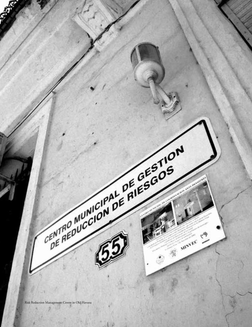
Risk Reduction Management Centre in Old Havana
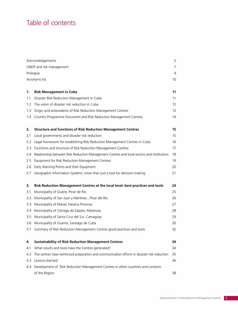
Systematization of Risk Reduction Management Centres 3
Acknowledgements 5
UNDP and risk management 7
Prologue 9
Acronyms list 10
1. Risk Management in Cuba 11
1.1 Disaster Risk Reduction Management in Cuba 11
1.2 The vision of disaster risk reduction in Cuba 12
1.3 Origin and antecedents of Risk Reduction Management Centres 13
1.4 Country Programme Document and Risk Reduction Management Centres 14
2. Structure and functions of Risk Reduction Management Centres 15
2.1 Local governments and disaster risk reduction 15
2.2 Legal framework for establishing Risk Reduction Management Centres in Cuba 16
2.3 Functions and structure of Risk Reduction Management Centres 17
2.4 Relationship between Risk Reduction Management Centres and local sectors and institutions 18
2.5 Equipment for Risk Reduction Management Centres 19
2.6 Early Warning Points and their Equipment 20
2.7 Geographic Information Systems: more than just a tool for decision-making 21
3. Risk Reduction Management Centres at the local level: best practices and tools 24
3.1. Municipality of Guane, Pinar de Río 25
3.2. Municipality of San Juan y Martínez , Pinar del Río 26
3.3. Municipality of Mariel, Havana Province 27
3.4 Municipality of Ciénaga de Zapata, Matanzas 28
3.5 Municipality of Santa Cruz del Sur, Camagüey 29
3.6 Municipality of Guamá, Santiago de Cuba 30
3.7 Summary of Risk Reduction Management Centres good practices and tools 32
4. Sustainability of Risk Reduction Management Centres 34
4.1 What results and tools have the Centres generated? 34
4.2 The centres have reinforced preparation and communication efforts in disaster risk reduction 35
4.3 Lessons learned 36
4.4 Development of Risk Reduction Management Centres in other countries and contexts
of the Region 38
Table of contents
Caribbean Risk Management Initiative4
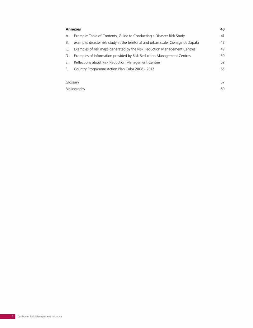
Annexes 40
A. Example: Table of Contents, Guide to Conducting a Disaster Risk Study 41
B. example: disaster risk study at the territorial and urban scale: Ciénaga de Zapata 42
C. Examples of risk maps generated by the Risk Reduction Management Centres 49
D. Examples of Information provided by Risk Reduction Management Centres 50
E. Reflections about Risk Reduction Management Centres 52
F. Country Programme Action Plan Cuba 2008 - 2012 55
Glossary 57
Bibliography 60
Systematization of Risk Reduction Management Centres 5
To the Joint Staff of National Civil Defence, author of the Risk Reduction Management Centres
initiative, for their constant support over the course of 50 years; to local governments and vulnerable
communities, for their actions to reduce disaster risk.
To the Ministry of Foreign Trade and Investment, for coordinating and supporting collabora-
tion regarding disaster risk reduction and presenting, as a priority, project proposals from governments,
institutions and Civil Defence, to different international cooperation actors present in Cuba.
To the United Nations Development Programme, for its leadership within the United Nations
System to support Cuban government policies in the field of disaster risk reduction.
To Provincial and Municipal Presidents, Civil Defence Heads and Staff, Risk Reduction Man-
agement Centres and Multi-disciplinary Group Members, for developing numerous and success-
ful experiences, shared in diverse settings and contexts, including those described in this publication.
To the Caribbean Risk Management Initiative, for its decisive support to this publication: this
included the original idea, discussion, revision of text, provision of documents, information, and the
necessary resources to manifest Civil Defence’s contribution on disaster risk reduction to worldwide
efforts, and in particular, to the Caribbean region.
To all of the above for making possible this publication.
Acknowledgements

Part of a Risk Reduction Management Centre equipment
Systematization of Risk Reduction Management Centres 7
UNDP and risk management
The United Nations’ Development Programme (UNDP) is the UN's global development network, an
organization advocating for change and connecting countries to knowledge, experience and resources
to help people build a better life. We are on the ground in 166 countries, working with them on their
own solutions to global and national development challenges. As they develop local capacity, they
draw on the people of UNDP and our wide range of partners.
As one of the key practice areas, the UNDP is working to assist countries to prevent crisis and en-
courage recovery, making the integration of risk reduction into the human development framework an
essential component. The Hyogo Framework for Action, approved in January 2005 as an outcome of
the World Conference on Disaster Reduction, guides UNDP’s collaboration in this area and is a decisive
step forward in putting disaster risk reduction on the international agenda.
In the Caribbean region, UNDP supports such objectives through the Bureau for Crisis Prevention
and Recovery (BCPR) and the Caribbean Risk Management Initiative (CRMI). In this way, UNDP provides
a platform for coordinating and sharing knowledge, skills, reflections, and discussion in the field of
climate change adaptation and disaster risk management, across language groups and cultures in the
Caribbean. A firm commitment exists in order to identify and promote best practices in the region so
that shared challenges can be addressed using a wide range of experiences and tools.
This document aims to systematize the best practices of the Cuban model of Risk Reduction Man-
agement Centres, which have been supported by UNDP Cuba through diverse initiatives. This model
establishes the possibility of mitigating disaster impacts through an informed, coordinated, multi-dis-
ciplinary and decentralized approach which focuses on identifying hazards and acting preemptively to
reduce risks. This approach has contributed to the excellent track record in Cuba of protecting human
life and livelihoods through preparedness and institutional capacity building at a local level.
In his preface to the 2009 Global Assessment Report on Disaster Risk Reduction, UN Secretary Gen-
eral Ban – Ki Moon urges a radical shift in development practices, and a major new emphasis on resil-
ience and disaster planning. He points to compelling evidence that suggests that investing in disaster
risk reduction is a cost-effective means to protect development, reduce poverty and adapt to climate
change. It is our hope that the documentation and sharing of this model of risk reduction serves the
broader community in its efforts to reduce risk and ensure the well-being of respective populations.
Mrs. Barbara Pesce-MonteiroRESIDENT REPRESENTATIVE, UNDP CUBA
Caribbean Risk Management Initiative8
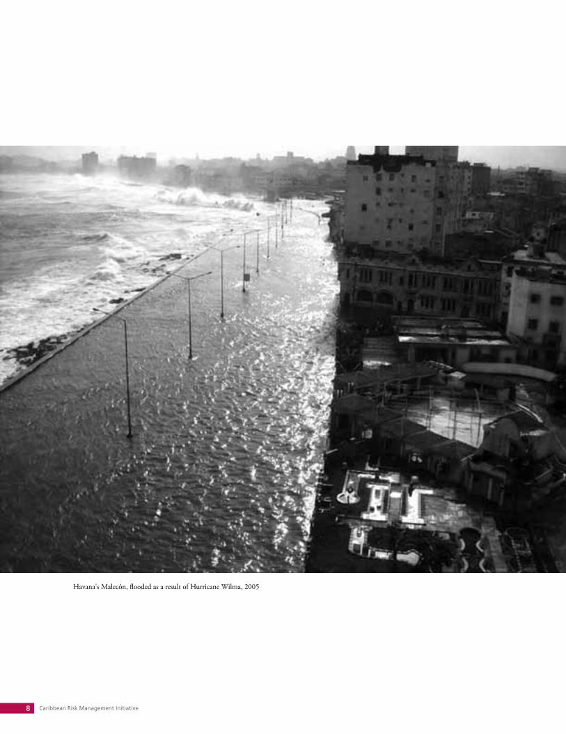
Havana's Malecón, flooded as a result of Hurricane Wilma, 2005
Systematization of Risk Reduction Management Centres 9
Prologue
The purpose of this publication is to present the Cuban experience in the creation of the Risk Reduc-
tion Management Centres. There is no recipe to make this model work in other countries; we simply
put forward this knowledge, given that it constitutes an important instrument for local governments in
managing preventative actions and decision-making in the area of disaster risk reduction.
Since the triumph of the Revolution Cuba has adopted a series of economic, social and environmen-
tal measures to reduce societal vulnerability in face of the natural, technological and health hazards.
The Risk Reduction Management Centres aim to compile and organize the necessary information
for risk studies, facilitate the control of vulnerability and create a culture of risk perception in the popu-
lation and the authorities, among its multiple activities, as part of the effort to perfect the Civil Defence
System of the country.
The Joint Staff of National Civil Defence (EMNDC) founded the Risk Reduction Management Cen-
tres in 2005, with the support and funding of UNDP and other agencies within the UN System. The
Centres are equipped with essential resources, subordinate to local governments in municipalities with
the greatest exposure to hazards, and are armed with the fundamental mission of achieving greater
effectiveness in the planning and undertaking of Civil Defence measures for the protection of the
population, economic resources and the environment.
In this material, the functions of the Risk Reduction Management Centres are explained, with a
focus on the principle activities and how they have achieved good results in the prevention of hydro-
meteorological risks in particular. However, this does not imply that all issues are resolved; to the con-
trary, as express in the title, we will continue to work in systematizing them.
This text is a modest presentation of a best practice, which we offer to authorities, organizations,
leaders of Civil Defence and protection, and all those interested in the topic in diverse areas of the
world. The objective is, depending on the particularities of each country, to work together for disaster
risk reduction, believing that if all take part in this, a better world is possible.
General Ramón Pardo Guerra HEAD OF JOINT STAFF OF NATIONAL CIVIL DEFENCE
Caribbean Risk Management Initiative10
Acronyms list
AECID Spanish International Cooperation Agency for Development *
ANAP National Association of Small Farmers *
BCPR Bureau for Crisis Prevention and Recovery
CDM Municipal Defence Council *
CDR Committees in Defence of the Revolution *
CDZ Zone Defence Council *
CPAP Country Programme Action Plan
CPD Country Programme Document
CRMI Caribbean Risk Management Initiative
DCDB Digital Cartographic Data Bases
DIPECHO Disaster Preparedness European Commission's Humanitarian Aid
DTM Digital Terrain Models
EMNDC Joint Staff of National Civil Defence *
EWP Early Warning Points
EWS Early Warning Systems
FMC Cuban Women’s Federation *
GIS Geographic Information System
IDERC National Spatial Data Infrastructure of the Republic of Cuba *
MINCEX Ministry of Foreign Trade and Investment *
MDG Millennium Development Goals
RRMC Risk Reduction Management Centre
UNDAF United Nations Development Assistance Framework
UNDP United Nations Development Programme
UNISDR United Nations International Strategy for Disaster Reduction
WFP World Food Programme
* Acronyms based on Spanish
Systematization of Risk Reduction Management Centres 11
1. Risk Management in Cuba
1.1 DISASTER RISk REDUCTION MANAGEMENT IN CUBA
Cuba is exposed to different risks of natural and other origins. Due to
its geographical location in the western Caribbean Sea, Cuba is affected
annually by intense hydro-meteorological events, primarily hurricanes.
The country’s hurricane season lasts for 6 months, from June 1st to No-
vember 30th. 2005 was noteworthy as it was extended to 6 January
2006, and was the most active season known in history.
Between 1998 and 2008, Cuba was struck by more than 20 tropi-
cal storms, of which 14 became hurricanes and seven were of great
intensity. During this time period, a total of 11 million people were
evacuated. Damage to infrastructure was considerable, with more than
one million houses affected and estimated economic losses at 18 billion
dollars. Despite this destruction, only 35 lives were lost.
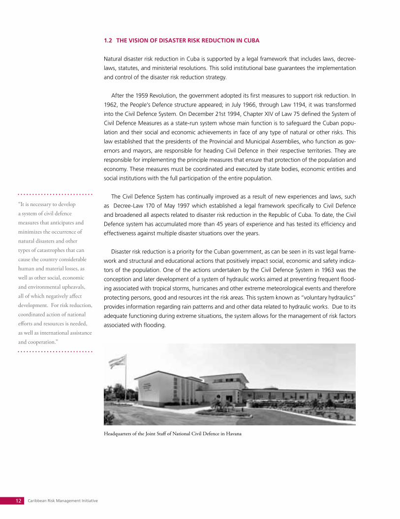
IMPACT DUE TO TROPICAL STORMS (in millions of Cuban Pesos CUP. 24 CUP = 1 USD)
Year/hurricanes Total Cost of preventive measures
Cost of replacing housing
2004 2.145,8 48,5 485,1
Charley (August) 1.222,7 9,1 432,6
Iván (September) 923,1 39,4 52,5
2005 3.036,0 117,2 1.074,8
Dennis (July) 2.124,8 18,7 1.026,1
Rita (September) 207,0 25,0 3,1
Wilma (October) 704,2 73,5 45,6
2006 95,1 15,2 24,6
Ernesto (September) 95,1 15,2 24,6
2007 1.155,4 12,8 364,4
Noel: Intense rains and tropical storm (October) 1.155,4 12,8 364,4
2008 9.759,3 137,7 4.983,8
Fay (August) 37,8 1,6 16,8
Gustav (September) 2.096,7 30,9 1.121,5
Ike (September) 7.325,3 95,9 3.764,7
Paloma (November) 299,5 9,3 80,8
Source: National Statistics Office.
The population most exposed to the destructive impact of these events are those living in isolated
coastal and mountainous zones. In these areas, settlements may remain incommunicado for several
days until the reestablishment of pre-existing conditions. Recovery activities are carried out in the
housing, critical services and infrastructure sectors based on existing Disaster Reduction Plans, or the
decisions made by Defence Councils at different territorial levels.
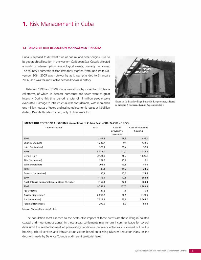
House in La Bajada village, Pinar del Rio province, affected by category 5 hurricane Ivan in September 2004
Caribbean Risk Management Initiative12
1.2 THE VISION OF DISASTER RISk REDUCTION IN CUBA
Natural disaster risk reduction in Cuba is supported by a legal framework that includes laws, decree-
laws, statutes, and ministerial resolutions. This solid institutional base guarantees the implementation
and control of the disaster risk reduction strategy.
After the 1959 Revolution, the government adopted its first measures to support risk reduction. In
1962, the People’s Defence structure appeared; in July 1966, through Law 1194, it was transformed
into the Civil Defence System. On December 21st 1994, Chapter XIV of Law 75 defined the System of
Civil Defence Measures as a state-run system whose main function is to safeguard the Cuban popu-
lation and their social and economic achievements in face of any type of natural or other risks. This
law established that the presidents of the Provincial and Municipal Assemblies, who function as gov-
ernors and mayors, are responsible for heading Civil Defence in their respective territories. They are
responsible for implementing the principle measures that ensure that protection of the population and
economy. These measures must be coordinated and executed by state bodies, economic entities and
social institutions with the full participation of the entire population.
The Civil Defence System has continually improved as a result of new experiences and laws, such
as Decree-Law 170 of May 1997 which established a legal framework specifically to Civil Defence
and broadened all aspects related to disaster risk reduction in the Republic of Cuba. To date, the Civil
Defence system has accumulated more than 45 years of experience and has tested its efficiency and
effectiveness against multiple disaster situations over the years.
Disaster risk reduction is a priority for the Cuban government, as can be seen in its vast legal frame-
work and structural and educational actions that positively impact social, economic and safety indica-
tors of the population. One of the actions undertaken by the Civil Defence System in 1963 was the
conception and later development of a system of hydraulic works aimed at preventing frequent flood-
ing associated with tropical storms, hurricanes and other extreme meteorological events and therefore
protecting persons, good and resources int the risk areas. This system known as “voluntary hydraulics”
provides information regarding rain patterns and and other data related to hydraulic works. Due to its
adequate functioning during extreme situations, the system allows for the management of risk factors
associated with flooding.
“It is necessary to develop a system of civil defence measures that anticipates and minimizes the occurrence of natural disasters and other types of catastrophes that can cause the country considerable human and material losses, as well as other social, economic and environmental upheavals, all of which negatively affect development. For risk reduction, coordinated action of national efforts and resources is needed, as well as international assistance and cooperation.”
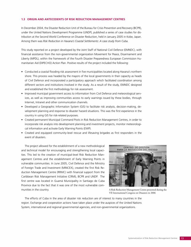
Headquarters of the Joint Staff of National Civil Defence in Havana
Systematization of Risk Reduction Management Centres 13
1.3 ORIGIN AND ANTECEDENTS OF RISk REDUCTION MANAGEMENT CENTRES
In December 2004, the Disaster Reduction Unit of the Bureau for Crisis Prevention and Recovery (BCPR),
under the United Nations Development Programme (UNDP), published a series of case studies for dis-
tribution at the Second World Conference on Disaster Reduction, held in January 2005 in Kobe, Japan.
Among them was Risk Reduction in Havana’s Coastal Settlements: A case study from Cuba.
This study reported on a project developed by the Joint Staff of National Civil Defence (EMNDC), with
financial assistance from the non-governmental organization Movement for Peace, Disarmament and
Liberty (MPDL), within the framework of the Fourth Disaster Preparedness European Commission Hu-
manitarian Aid (DIPECHO) Action Plan. Positive results of the project included the following:
Conducted a coastal flooding risk assessment in five municipalities located along Havana’s northern •
shore. This process was headed by the mayors of the local governments in their capacity as heads
of Civil Defence and incorporated a participatory approach which facilitated coordination among
different sectors and institutions involved in the study. As a result of the study, EMNDC designed
and established the first methodology for risk assessment.
Improved municipal government access to information from Civil Defence and meteorological serv-•
ices, as well as improving communities access to early warnings issued by these bodies, through
Internet, Intranet and other communication channels.
Developed a Geographic Information System (GIS) to facilitate risk analysis, decision-making, de-•
velopment planning and response to disaster hazard situations. This was the first experience in the
country in using GIS for risk-related purposes.
Created permanent Municipal Command Posts in Risk Reduction Management Centres, in order to •
incorporate risk analysis into development planning and investment projects, monitor meteorologi-
cal information and activate Early Warning Points (EWP).
Created and equipped community-level rescue and lifesaving brigades as first responders in the •
event of disasters.
The project allowed for the establishment of a new methodological
and technical model for encouraging and strengthening local capaci-
ties. This led to the creation of municipal-level Risk Reduction Man-
agement Centres and the establishment of Early Warning Points in
vulnerable communities. In June 2005, Civil Defence and the Ministry
of Foreign Trade and Investment (MINCEX), created the first Risk Re-
duction Management Centre (RRMC) with financial support from the
Caribbean Risk Management Initiative (CRMI), BCPR and UNDP. The
first centre was located in Guamá Municipality in Santiago de Cuba
Province due to the fact that it was one of the most vulnerable com-
munities in the country.
The efforts of Cuba in the area of disaster risk reduction are of interest to many countries in the
region. Exchange and cooperation actions have taken place under the auspices of the United Nations
System, international and regional governmental agencies, and non-governmental organizations.
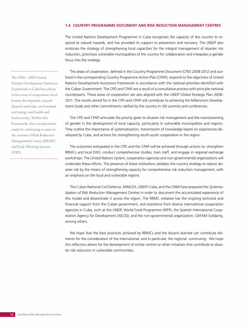
A Risk Reduction Management Centre presented during the VII International Congress on Disasters in 2006
Caribbean Risk Management Initiative14
1.4 COUNTRy PROGRAMME DOCUMENT AND RISk REDUCTION MANAGEMENT CENTRES
The United Nations Development Programme in Cuba recognizes the capacity of the country to re-
spond to natural hazards, and has provided its support to prevention and recovery. The UNDP also
endorses the strategy of strengthening local capacities for the integral management of disaster risk
reduction, prioritizes vulnerable municipalities of the country for collaboration and integrates a gender
focus into the strategy.
The areas of cooperation, defined in the Country Programme Document (CPD) 2008-2012 and out-
lined in the corresponding Country Programme Action Plan (CPAP), respond to the objectives of United
Nations Development Assistance Framework in accordance with the national priorities identified with
the Cuban Government. The CPD and CPAP are a result of a consultative process with principle national
counterparts. These areas of cooperation are also aligned with the UNDP Global Strategic Plan 2008-
2011. The results aimed for in the CPD and CPAP will contribute to achieving the Millennium Develop-
ment Goals and other commitments ratified by the country in UN summits and conferences.
The CPD and CPAP articulate the priority given to disaster risk management and the mainstreaming
of gender in the development of local capacity, particularly in vulnerable municipalities and regions.
They outline the importance of systematization, transmission of knowledge based on experiences de-
veloped by Cuba, and actions for strengthening south-south cooperation in the region.
The outcomes anticipated in the CPD and the CPAP will be achieved through actions to: strengthen
RRMCs and local EWS, conduct comprehensive studies, train staff, and engage in regional exchange
workshops. The United Nations System, cooperation agencies and non-governmental organizations will
undertake these efforts. The presence of these institutions validates the country strategy to reduce dis-
aster risk by the means of strengthening capacity for comprehensive risk reduction management, with
an emphasis on the local and vulnerable regions.
The Cuban National Civil Defence, MINCEX, UNDP-Cuba, and the CRMI have prepared the Systema-
tization of Risk Reduction Management Centres in order to document the accumulated experience of
this model and disseminate it across the region. The RRMC initiative has the ongoing technical and
financial support from the Cuban government, and assistance from diverse international cooperation
agencies in Cuba, such as the UNDP, World Food Programme (WFP), the Spanish International Coop-
eration Agency for Development (AECID), and the non-governmental organization, OXFAM Solidarity,
among others.
We hope that the best practices achieved by RRMCs and the lessons learned can contribute ele-
ments for the consideration of the international, and in particular, the regional community. We hope
this reflection allows for the development of similar centres or other initiatives that contribute to disas-
ter risk reduction in vulnerable communities.
The 2008 – 2010 United Nations Development Assistance Framework in Cuba has a focus in five areas of cooperation: local human development, natural disasters and risks, environment and energy, and health and food security. Within this Framework, there are provisions made for continuing to assist in the creation of Risk Reduction Management Centres (RRMC) and Early Warning Systems (EWS)
Systematization of Risk Reduction Management Centres 15
2. Structure and functions of Risk Reduction Management Centres
2.1 LOCAL GOVERNMENTS AND DISASTER RISk REDUCTION
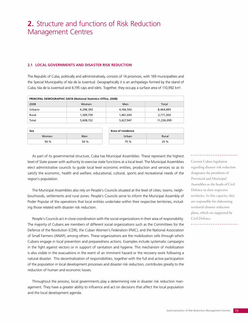
The Republic of Cuba, politically and administratively, consists of 14 provinces, with 169 municipalities and
the Special Municipality of Isla de la Juventud. Geographically it is an archipelago formed by the island of
Cuba, Isla de la Juventud and 4,195 cays and islets. Together, they occupy a surface area of 110,992 km2.
PRINCIPAL DEMOGRAPHIC DATA (National Statistics Office, 2008)
2008 Women Men Total
Urbano 4,298,393 4,166,502 8,464,895
Rural 1,309,759 1,461,445 2,771,204
Total 5,608,152 5,627,947 11,236,099
Sex Area of residence
Women Men Urban Rural
50 % 50 % 75 % 25 %
As part of its governmental structure, Cuba has Municipal Assemblies. These represent the highest
level of State power with authority to exercise state functions at a local level. The Municipal Assemblies
elect administrative councils to guide local level economic entities, production and services so as to
satisfy the economic, health and welfare, educational, cultural, sports and recreational needs of the
region’s population.
The Municipal Assemblies also rely on People's Councils situated at the level of cities, towns, neigh-
bourhoods, settlements and rural zones. People's Councils serve to inform the Municipal Assembly of
Poder Popular of the operations that local entities undertake within their respective territories, includ-
ing those related with disaster risk reduction.
People's Councils act in close coordination with the social organizations in their area of responsibility.
The majority of Cubans are members of different social organizations such as the Committees for the
Defence of the Revolution (CDR), the Cuban Women’s Federation (FMC), and the National Association
of Small Farmers (ANAP), among others. These organizations are the mobilization cells through which
Cubans engage in local prevention and preparedness actions. Examples include systematic campaigns
in the fight against vectors or in support of sanitation and hygiene. This mechanism of mobilization
is also visible in the evacuations in the event of an imminent hazard or the recovery work following a
natural disaster. This decentralization of responsibilities, together with the full and active participation
of the population in local development processes and disaster risk reduction, contributes greatly to the
reduction of human and economic losses.
Throughout the process, local governments play a determining role in disaster risk reduction man-
agement. They have a greater ability to influence and act on decisions that affect the local population
and the local development agenda.
Current Cuban legislation regarding disaster risk reduction designates the presidents of Provincial and Municipal Assemblies as the heads of Civil Defence in their respective territories. In this capacity, they are responsible for elaborating territorial disaster reduction plans, which are supported by Civil Defence.
Caribbean Risk Management Initiative16
2.2 LEGAL FRAMEWORk FOR ESTABLISHING RISk REDUCTION MANAGEMENT CENTRES IN
CUBA
In the May 1997 Decree-Law 170 of the Civil Defence System an explicit definition of disaster reduction
appears for the first time. It is defined as a group of activities for prevention, preparedness, response
and recovery aimed at protecting the population, the economy and the environment from the destruc-
tive consequences of natural or other types of disasters or catastrophes.
On the 30th of November 2004, authorities convened a national meeting to analyze the impact of,
response to and recovery from 2004 Hurricanes Charley and Ivan. As a result, the Vice-President of the
National Defence Council issued Directive No 1. This directive mandated anew how to plan, organize
and prepare for disaster risks in the country. It established the process and development of disaster
risk assessments and studies as a requirement for elaborating disaster reduction plans for regions and
economic sectors.
After assessing risk in a municipality, the Government establishes an order of priorities to reduce
identified vulnerabilities. This implies planning the necessary material and financial resources for the
gradual reduction of risk, until it reaches a level considered acceptable for all. To facilitate this work
at the local governmental level, Cuban Civil Defence created the Risk Reduction Management Centre
strategy and prioritized their implementation for the most vulnerable municipalities. The first RRMCs
created in Havana and Pinar del Río, with the assistance of the UNDP, were a result of the analysis of
the impact of Hurricanes Charley and Ivan.
Cuba, through its Civil Defence System and legal framework, institutional capacities and social or-
ganization, has developed instruments and tools that enable it to assess risk and draw up a set of ac-
tions for prevention, preparation and effective response to disasters. Thus, the society is increasingly
in a better position to influence the elements that create vulnerabilities and to transform the human
causes of disasters.
The Cuban initiative to create Risk Reduction Management Centres (RRMCs) makes it easier for local governments to monitor the decrease of vulnerabilities at this level. These centres contribute to the coordination process, and promote training and preparedness of leadership bodies and the community.
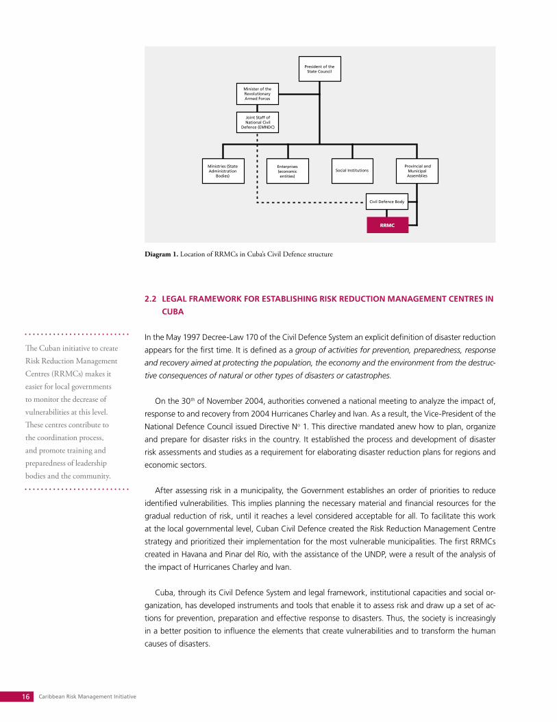
Diagram 1. Location of RRMCs in Cuba’s Civil Defence structure
Systematization of Risk Reduction Management Centres 17
2.3 FUNCTIONS AND STRUCTURE OF RISk REDUCTION MANAGEMENT CENTRES
The main function of Risk Reduction Management Centres is to create better access, documenta-
tion and transmission of critical information. To do this, RRMCs use existing and appropriate suitable
technologies to help local governments make decisions. The aim is to reduce loss of life and economic
assets, and ensure a better quality of life and local sustainable development for the territory.
The centres are also responsible for transforming information into a vital input, making it useful to
different institutions, organizations and local actors for purposes of knowledge, learning, feedback and
exchange of tools. The aim is to foster collaboration in decision-making regarding development proc-
esses and disaster risk reduction in the regions. In addition, an important feature of a Centre is that it
offers access to other available information sources through Intranet and Internet.
At the direction of the Head of the Joint Staff of National Civil Defence, the RRMCs are directly
subordinate to the presidents of the local Municipal Assemblies, in their capacity as territorial heads of
Civil Defence. The local head of Civil Defence will assist the President in the task of making the RRMC
operational and functioning. The Assembly President signs resolutions and other normative documents
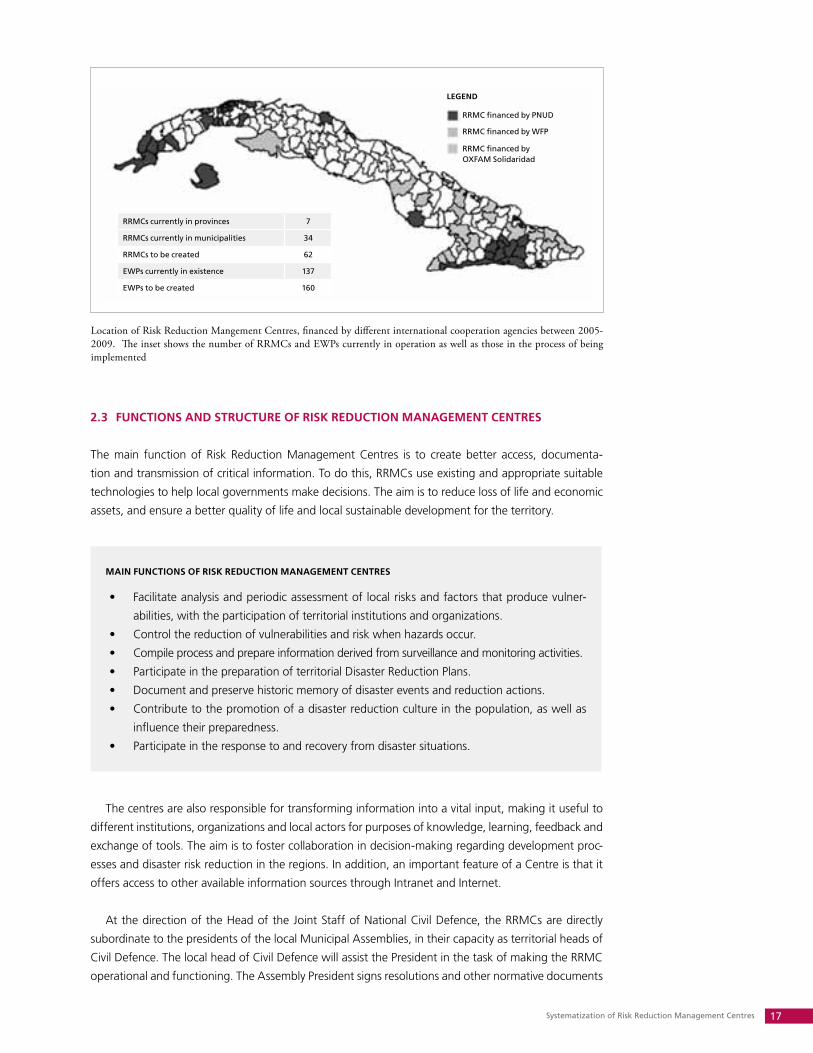
Location of Risk Reduction Mangement Centres, financed by different international cooperation agencies between 2005-2009. The inset shows the number of RRMCs and EWPs currently in operation as well as those in the process of being implemented
MAIN FUNCTIONS OF RISk REDUCTION MANAGEMENT CENTRES
Facilitate analysis and periodic assessment of local risks and factors that produce vulner-•
abilities, with the participation of territorial institutions and organizations.
Control the reduction of vulnerabilities and risk when hazards occur.•
Compile process and prepare information derived from surveillance and monitoring activities.•
Participate in the preparation of territorial Disaster Reduction Plans.•
Document and preserve historic memory of disaster events and reduction actions. •
Contribute to the promotion of a disaster reduction culture in the population, as well as •
influence their preparedness.
Participate in the response to and recovery from disaster situations.•
RRMCs currently in provinces 7
RRMCs currently in municipalities 34
RRMCs to be created 62
EWPs currently in existence 137
EWPs to be created 160
LEGEND
RRMC financed by PNUD
RRMC financed by WFP
RRMC financed by OXFAM Solidaridad
Caribbean Risk Management Initiative18
which regulate the internal functioning of the Centres based on respective needs and possibilities.
This includes the designation of a director and two staff members specifically skilled to coordinate the
centre and adequately identify, collect and analyze relevant information. These regulations provide the
legal character to the process that ensures that the Centre’s role will continue to function beyond the
duration of project.
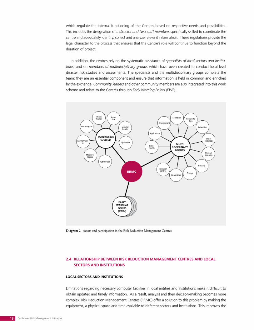
In addition, the centres rely on the systematic assistance of specialists of local sectors and institu-
tions, and on members of multidisciplinary groups which have been created to conduct local level
disaster risk studies and assessments. The specialists and the multidisciplinary groups complete the
team; they are an essential component and ensure that information is held in common and enriched
by the exchange. Community leaders and other community members are also integrated into this work
scheme and relate to the Centres through Early Warning Points (EWP).
2.4 RELATIONSHIP BETWEEN RISk REDUCTION MANAGEMENT CENTRES AND LOCAL
SECTORS AND INSTITUTIONS
LOCAL SECTORS AND INSTITUTIONS
Limitations regarding necessary computer facilities in local entities and institutions make it difficult to
obtain updated and timely information. As a result, analysis and then decision-making becomes more
complex. Risk Reduction Management Centres (RRMC) offer a solution to this problem by making the
equipment, a physical space and time available to different sectors and institutions. This improves the
Diagram 2. Actors and participation in the Risk Reduction Management Centres
Systematization of Risk Reduction Management Centres 19
breadth and depth of the results pertaining to surveillance systems and the control of indicators meas-
uring reduction in vulnerability.
Health, housing, agriculture, environment, water, sanitation and land planning are the sectors and
institutions with the greatest representation in the work of the RRMC. This is due to the fact that these
institutions play key roles in the local development and investment agenda and are the greatest ben-
eficiaries of risk reduction strategies. Specialists of each sector work closely with the RRMC to provide
and update information concerning their respective institution’s scope of work. S/he would also obtain
information from other sectors in a feedback mechanism through the Centre. For example, provincial
and municipal health authorities deliver information on the health status of municipalities and People’s
Councils. In turn, they receive health status assessments and updates on other services and resources
required for their operation. This feedback mechanism would include updates on the condition of criti-
cal services such as water, electricity, public works, sanitation and transport.
MULTIDISCIPLINARy GROUPS
Local level multidisciplinary groups are formed in response to instructions from the Head of the Joint
Staff of National Civil Defence. Their objective is to conduct a local territorial vulnerability analysis, in
accordance with the country’s established legal framework. This is used to update the local risk levels.
Based on approved methodologies, these groups inform the local government and Civil Defence of the
scientific and technical elements necessary to take into account when a decision is requiered to prevent
or respond to disasters or plan for sustainable territorial development.
RRMCs make communication tools and resources available in order to conduct the risk studies.
As a central hub function, it is the role of the RRMC to receive these studies and use them to update
municipal disaster reduction plans. This allows for more efficient decision-making in situations of both
socio-economic development and disasters.
In Cuba all regions possess adequate human resources, by sector and within institutions, with the ca-
pacity to develop the above-mentioned studies. What is innovative about the RRMC model is that these
human resources are permanently integrated into a local level multidisciplinary group, with the defined
aim of analyzing topics related to risk reduction in their territories. As a result, municipalities and their
communities do not depend on externally trained human resources – either from national institutions or
international consultants - in order to conduct these studies or to provide advice to decision-makers.
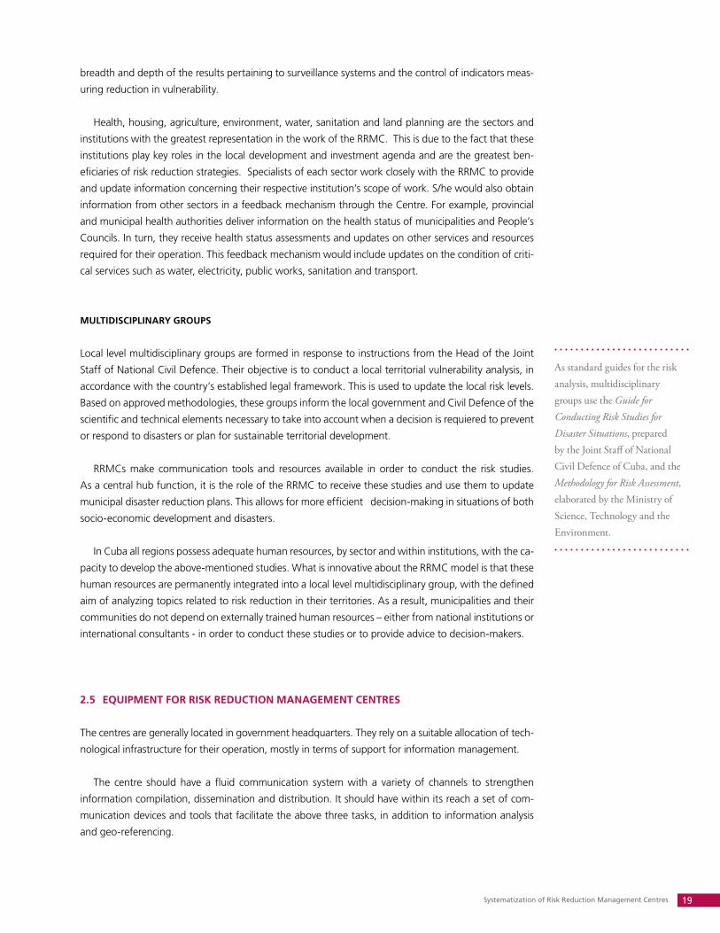
2.5 EqUIPMENT FOR RISk REDUCTION MANAGEMENT CENTRES
The centres are generally located in government headquarters. They rely on a suitable allocation of tech-
nological infrastructure for their operation, mostly in terms of support for information management.
The centre should have a fluid communication system with a variety of channels to strengthen
information compilation, dissemination and distribution. It should have within its reach a set of com-
munication devices and tools that facilitate the above three tasks, in addition to information analysis
and geo-referencing.
As standard guides for the risk analysis, multidisciplinary groups use the Guide for Conducting Risk Studies for Disaster Situations, prepared by the Joint Staff of National Civil Defence of Cuba, and the Methodology for Risk Assessment, elaborated by the Ministry of Science, Technology and the Environment.
Caribbean Risk Management Initiative20
The initial investment in these resources is approximately $12,000 USD. Maintenance, operating and
replacement costs are assumed by governments within their operating budgets, including costs for hu-
man, or communication resources as well as the locale and other facilities required. These expenses are,
without question, much less than the total value of the benefits provided by a risk reduction emphasis
when a region is affected by a natural hazard.
2.6 EARLy WARNING POINTS AND THEIR EqUIPMENT
In Cuba, the Early Warning System (EWS) is understood as an integrated process including surveillance,
monitoring and analysis of natural and other variables that might constitute a hazard for the population
and economy. These variables are assessed by Civil Defence authorities to facilitate decision-making and
the enactment, by agencies, organizations, economic entities, social institutions and the population of
the region, of the measures approved in the disaster reduction plans for each phase of an event.
MODULE FOR EqUIPPING A CENTRE
Up to 3 computers, with printer and modem with Inter-•
net connection
Minimum of 2 telephone numbers•
Portable 2.3 kW generator•
Television set•
DVD Player•
Communication radio (shortwave and very shortwave)•
Portable communication radios•
Radio recorder•
Rechargeable emergency lamp•
Digital camera•
Flashlights•
Acrylic blackboard•
Rain capes, boots and safety hats•
Furniture•
Acrylics and boards for signage•
REqUIREMENTS FOR PREMISES SELECTED FOR RISk REDUCTION MANAGEMENT CENTRES
Preferably located in the headquarters of the provincial or municipal local government •
Dimensions of the locale must not be less than 5 metres in length by 4 metres in width (20m• 2)
Adequate security and protection for safeguarding of designated resources•
The building type and condition of the structure must guarantee safety and function in a •
disaster situation
Availability of at least 4 electric sockets of 110 volts and 1 socket of 220 volts, to facilitate the •
installation of equipment and two permanent telephone lines
Provision of 2 double lamps for illumination•

Systematization of Risk Reduction Management Centres 21
This system is appropriate for the socio-economic characteristics, institutional strengths, social organi-
zation, and level of education and preparedness of the population. Protection measures are adopted and
executed efficiently, allowing for minimal human and economic losses. For these reasons, Civil Defence
has established, as a requirement in municipalities where RRMCs are created, the implementation of
Early Warning Points (EWP). These are intended for communities of 300 or more inhabitants that are
likely to be incommunicado in case of an event, or have a greater incidence of natural or other hazards.
The EWP is a basic element for the operation of the Early Warning System.
The EWPs are the responsibility of the community leaders, namely the presidents of the People’s
Councils, who in turn depend on the help of community members to operate the equipment. The EWP
equipment is located either in the premises of the People’s Councils, schools, entities such as post of-
fices or water resources offices, or even family homes when the situation demands it, where its func-
tion, preservation and use is guaranteed.
The RRMC send the EWP essential information regarding the occurrence and characteristics of a
hazard, as well as decisions, regulations, established phases and actions for the community to carry out
in response to it. The People’s Councils undertake the planned and approved protection measures laid
out in the disaster risk reduction plan and publicize necessary information throughout the community,
including norms of conduct to adopt in face of a hazard.
The EWPs provide feedback to the RRMCs by sending them information regarding the situation in
the communities and the nature and variables of the risks that affect them. Using this information, the
Municipal Government is able to analyze different situations and adopt the anticipated measures.
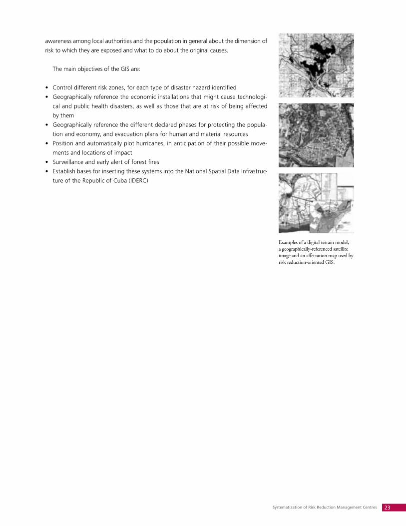
2.7 GEOGRAPHIC INFORMATION SySTEMS: MORE THAN JUST A TOOL FOR DECISION-
MAkING
A Geographic Information System (GIS) is an organized integration of hardware, software and geo-
graphic data designed to capture, store, edit, analyze, share and display geographically referenced infor-
mation. It is used to resolve complex problems of planning and management. In a more general sense,
the GIS is a tool that allows its users to perform interactive requests, analyze spatial information, revise
data and maps, and present results of these operations.
MODULE FOR EqUIPPING AN EARLy WARNING POINT
Portable 2.3 kW generator•
Communication radio (shortwave and very shortwave)•
Personal communication radio•
Megaphones•
Rechargeable Emergency Lamp•
Radio •
Flashlight •
Rain Capes, Boots and Safety Hats•
Caribbean Risk Management Initiative22
To satisfy the concrete information needs of the RRMCs, a vectorial model of data has been con-
structed based on the geo-reference of graphic information, as established by Directive No. 1/2005.
This cartographic information can be classified into three types:
Basic digital cartography• : this contains the main topographical elements of the terrain such as sur-
veys, hydrographics, relief, and vegetation and is obtained from topographic maps. Existing Digital
Terrain Models (DTM) with different scales are used, as well as other Digital Cartographic Data Bases
(DCDB).
Thematic data bases• : this is a geographically reference information established by Directive No.1/2005
that is not included in topographic maps. This information is obtained from other cartographic ma-
terials, aerial or satellite photographs, geographic and risk studies, vulnerability and territorial risk,
direct survey or with GPS.
Disaster reduction plan data bases• : these are created to geographically reference different elements
of the terrain depicted in the digital cartographic base such as defence zones or population points.
These data bases include:
Population still requiring protection •
Livestock to evacuate•
Protected population•
Economic and social installations and service networks that might be affected by a hazard •
Flood areas depending on rain fall pattern •
Population affected by storm surge •
MAIN OBJECTIVES OF GIS FOR THE CENTRES
GIS is a tool for planning and coordination that facilitates decision-making in complex development
processes. In terms of disaster risk reduction, the use of GIS in the RRMC has resulted in increased
REqUIRED DATA FOR DISASTER REDUCTION PLANS ESTABLISHED IN DIRECTIVE NO.1/2005
Territorial boundaries•
Location of command posts and points•
Main vulnerable areas•
Main reservoirs, rivers, canals, water conductors, pumping stations and waterworks plants •
Airports, small plazas for helicopters, air corridors, areas for protecting watercraft•
Medical institutions and institutions for veterinary medicine and plant health•
Firefighting squads•
Entities that handle dangerous substances •
Shelters and food preparation centres•
Evacuation site for livestock •
Location of ham radio operators•
Generation plants and high voltage electrical lines•
Transport bases•
Meteorological stations, radars and other monitoring and forecast institutions•
Systematization of Risk Reduction Management Centres 23
awareness among local authorities and the population in general about the dimension of
risk to which they are exposed and what to do about the original causes.
The main objectives of the GIS are:
Control different risk zones, for each type of disaster hazard identified•
Geographically reference the economic installations that might cause technologi-•
cal and public health disasters, as well as those that are at risk of being affected
by them
Geographically reference the different declared phases for protecting the popula-•
tion and economy, and evacuation plans for human and material resources
Position and automatically plot hurricanes, in anticipation of their possible move-•
ments and locations of impact
Surveillance and early alert of forest fires •
Establish bases for inserting these systems into the National Spatial Data Infrastruc-•
ture of the Republic of Cuba (IDERC)
Examples of a digital terrain model, a geographically-referenced satellite image and an affectation map used by risk reduction-oriented GIS.
Caribbean Risk Management Initiative24
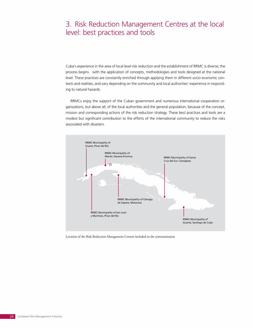
3. Risk Reduction Management Centres at the local level: best practices and tools
Cuba’s experience in the area of local level risk reduction and the establishment of RRMC is diverse; the
process begins with the application of concepts, methodologies and tools designed at the national
level. These practices are constantly enriched through applying them in different socio-economic con-
texts and realities, and vary depending on the community and local authorities’ experience in respond-
ing to natural hazards.
RRMCs enjoy the support of the Cuban government and numerous international cooperation or-
ganizations, but above all, of the local authorities and the general population, because of the concept,
mission and corresponding actions of the risk reduction strategy. These best practices and tools are a
modest but significant contribution to the efforts of the international community to reduce the risks
associated with disasters.
RRMC Municipality of Guane, Pinar del Rio
RRMC Municipality of Mariel, Havana Province
RRMC Municipality of San Juan y Martinez, Pinar del Rio
RRMC Municipality of Ciénaga de Zapata, Matanzas
RRMC Municipality of Santa Cruz del Sur, Camagüey
RRMC Municipality of Guamá, Santiago de Cuba
Location of the Risk Reduction Management Centres included in the systematization
Systematization of Risk Reduction Management Centres 25
3.1. MUNICIPALITy OF GUANE, PINAR DE RíO
This centre was established in April 2006, in the seat of the Municipal Assembly, with
UNDP funding.
GEOGRAPHIC LOCATION
Southwest Pinar del Río Province
BOUNDARIES
Mantua Municipality to the North; En-senada de Cortés to the South; Minas de Matahambre and San Juan y Martínez municipalities to the East; Sandino and Mantua municipalities to the West.
SURFACE AREA
717.29 km2
POPULATION
35,760 inhabitants, 53.4% in urban areas, 46.6% in rural areas.
POPULATION DENSITy
50.15 inhabitants/km2
SETTLEMENTS
8 People’s Councils, 22 settlements of more than 200 inhabitants and 12 with less than 200 inhabitants.
TOPOGRAPHy
Undulating, 55% plains and 45% eleva-tions and mountains.
ECONOMIC ACTIVITIES
Tobacco cultivation, forestry, fishing and mixed crops. DISASTER HAZARDS
Natural origin: Hurricanes, intense rains, severe local storms, storm surges, intense droughts and forest fires. Sanitary origin: Diseases that can cause epidemics, epizootics, epiphytotics and quarantined pests.
RISk STUDIES
Territorial disaster risk study
EARLy WARNING POINTS
Three (3) EWPs
ACHIEVEMENTS AND BEST PRACTICES
Creation of a municipal information system for risk reduction, which allows information
generated by the municipality’s different social and economic sectors to be transmitted and received
either electronically or directly in digital form. An example of this would be territorial health informa-
tion which reflects the state of environmental sanitation, and in particular, water. The territorial health
analysis would provide information concerning the control of liquid and solid wastes, the main con-
tamination focal points, vectors and measures to eradicate them, and educational activities. It would
also include an analysis of the principle diseases, incidence of mortality and morbidity rates distributed
per People’s Council, residential block composition, and the organizations at the block level.
Preparation and updating of digital data bases in the service of risk reduction. These
tools contribute to municipal decision-making when faced with the impact of natural hazards, and
other risks that might occur in the municipality. The government utilizes the updated information
regarding the population in high risk areas that may require evacuation. This information, to serve
evacuation plans, is categorized by type of hydro-meteorological risk, by People’s Councils, by vot-
ing registry, and block organization (CDR). The information also helps in the preparation of a control
plan for all municipal transport vehicles, based on type of vehicle and technical condition, the entity
to which the vehicle belongs, and the communities to which they are assigned to for evacuation and
other activities to protect the people and economy.
Joint identification, promotion and participation with other sectors and institutions in
local preparedness and training projects for disaster risk reduction, through the Guaní-Sciences
project. This community preparation project has conducted capacity building activities in several com-
munities vulnerable to disaster risks, including Catalina, Bailén, Paso Piedra, Laguna Vieja and La
Güira. Municipal authorities from culture, health, education, science, technology and the environ-
ment were key collaborators, among others.
TOOLS GENERATED
Municipal information system methodology•
Procedures for updating databases by municipal sectors and institutions•
Training programme for communities vulnerable to natural risks•
Input provided to update the territorial Disaster Reduction Plan and risk studies•
Historical documentation on natural hazards that have affected the municipality: • Las fieras del
Caribe a su paso por Guane and the video Experiencias del Centro Municipal de Evacuación al
paso del huracán Ike
Caribbean Risk Management Initiative26
3.2. MUNICIPALITy OF SAN JUAN y MARTíNEZ , PINAR DEL RíO
The centre was constituted in May 2006, in the seat of the Municipal Assembly, with
UNDP funding.
GEOGRAPHIC LOCATION
Southwest Pinar del Río Province
BOUNDARIES
Minas de Matahambre Municipality to the North; Ensenada de Cortés to the South; Pinar del Río and San Luis municipalities to the East; Guane Municipality to the West.
SURFACE AREA
4,092 km2
POPULATION
45,030 inhabitants, 34.4% in urban areas and 65.6% in rural areas.
POPULATION DENSITy
113.9 inhabitants/km2
SETTLEMENTS
10 People’s Councils, 63 concentrated settlements, 3 are urban cores.
TOPOGRAPHy
53% mountainous zones and 43% plains.
ECONOMIC ACTIVITIES
Tobacco cultivation, forestry, fishing and mixed crops. DISASTER HAZARDS
Natural origin: Hurricanes, intense rains, storm surges, intense droughts and forest fires. Sanitary origin: Diseases that can cause epidemics, epizootics, epiphy-totics and quarantined pests.
RISk STUDIES
Territorial disaster risk study
EARLy WARNING POINTS
Three (3) EWPs
ACHIEVEMENTS AND BEST PRACTICES
Preparation and updating of a digital data base of the vulnerabilities associated with
the municipality’s key sectors. These data bases include analysis from the education, public health,
housing, physical planning, hydraulic resources, communications and transport sectors. Such a data
base allows different sectors to elaborate work strategies to reduce vulnerabilities. The housing sector
data based is a good example of this. It records that, between 2002 and 2009, 10,900 residences
out of a 12,000 strong housing stock were affected by hurricanes. In response, a series of actions
monitored by the RRMC have been taken to reduce the vulnerability of these houses to hazards.
Creation of a geographic information system (GIS) to reduce municipal risk. GIS provides
key details about the People’s Councils, evacuation shelters and food preparation centres.GIS facili-
tates, through a digital terrain model, the identification of areas affected by dam rupture, intense
rains and storm surge. It also helps identify geo-referenced points of interest through the use of sat-
ellite images. A good example is the geo-referencing of tobacco curing sheds, key economic locales
which are vulnerable to hurricanes and strong winds.
Perfection of disaster reduction measures for forest fires. The municipal has a goal of dimin-
ishing the extent of this hazard throughout its territory. The plan called for improvement to the sur-
veillance and early warning system, the creation of two specialized brigades and 6 voluntary brigades,
and public awareness campaigns for the population living in areas of greatest risk of forest fires.
TOOLS GENERATED
Maps of damaged housing and population at risk from intense rains•
Territorial zone and land-use plan for the housing sector•
Inputs to update the Disaster Reduction Plan and studies on vulnerability and disaster risk •
Guide to action in the event of forest fires•
Digital information and its cartographic representation•
Public awareness programme on forest fire prevention measures•
Systematization of Risk Reduction Management Centres 27
GEOGRAPHIC LOCATION
Northwest Havana Province
BOUNDARIES
Florida Straits to the North; Guanajay and Artemisa municipalities to the South; Caimito Municipality to the East; Bahía Honda Municipality, Pinar del Río, to the West.
SURFACE AREA
272 km2
POPULATION
43,169 inhabitants, 78.86 % in urban areas, 21.14 % in rural areas.
POPULATION DENSITy
158.63 inhabitants/km2
SETTLEMENTS
5 People’s Councils, 32 settlements in the municipality, 8 are urban and 24 are rural. Of the latter, 9 have more than 200 inhabitants and 15 have less than 200 inhabitants.
TOPOGRAPHy
Undulating, 35% plains and 65% hilly.
ECONOMIC ACTIVITIES
Cement production and export, electri-cal generation, marble processing, ex-port and import of goods at Mariel Port, forestry, fishing and mixed crops. DISASTER HAZARDS
Natural origin: Hurricanes, severe local storms, prefrontal lightning storms, intense rains, intense droughts, storm surges, earthquake, landslides, fires in rural areas.Technological origin: Rupture of hydrau-lic works, building collapse, dangerous substance accidents, large fires in indus-trial complexes and social buildings, traf-fic accidents, hydrocarbon spillage. Sanitary origin: Epidemics, epizootics, epiphytotics.
RISk STUDIES
Disaster risk studies: health, landslides, hydrocarbon spillage, seismological, and storm surges.
EARLy WARNING POINTS
Three (3) EWPs
3.3. MUNICIPALITy OF MARIEL, HAVANA PROVINCE
The centre was established on 15 January 2007, in the seat of the Municipal Assembly, with
UNDP funding.
ACHIEVEMENTS AND BEST PRACTICES
Creation of a municipal information system for risk reduction. This information system
allows for the reception of information generated by the municipality’s different social and economic
sectors either electronically or directly in digital form. An example is the state of territorial health and
environmental sanitation, in particular water: distribution in both quantity and quality, critical areas
that do not receive water services, chlorination levels, and health warnings.
Reception of information from national and provincial warning and monitoring systems.
The RRMC receives meteorological, seismological and hydrological information, such as water levels
in dams and precipitation levels. The RRMC transmits, in real time, this information to the Municipal
Assembly and to People’s Councils that have Early Warning Points. The acquired equipment, along
with available municipal information and communication facilities, also allows for access to interna-
tional warning systems and Internet based information.
Training in the most vulnerable communities. In the urban area of Mariel target training in
disaster reduction has been offered to the population living in landslide zones. In addition, training
in risk management has been provided to approximately 300 officials in the health, housing, physi-
cal planning, and education sectors as well as to members of political and mass organizations and
enterprises.
TOOLS GENERATED
Municipal information system methodology•
Procedures for updating databases by municipal sectors and institutions.•
Training programme for communities vulnerable to natural hazards•
Input provided to update the territorial Disaster Reduction Plan and risk studies.•
Landslide risk map•
Documentation on natural hazard that have affected the municipality of Mariel•
Caribbean Risk Management Initiative28
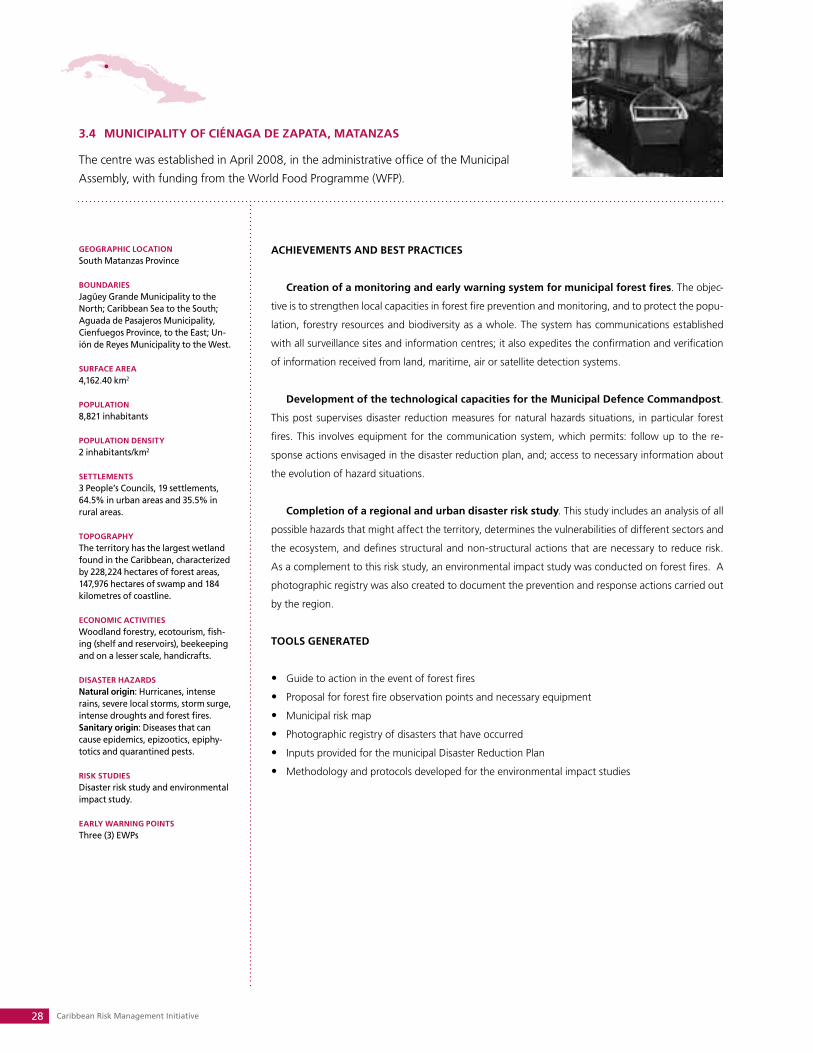
3.4 MUNICIPALITy OF CIéNAGA DE ZAPATA, MATANZAS
The centre was established in April 2008, in the administrative office of the Municipal
Assembly, with funding from the World Food Programme (WFP).
GEOGRAPHIC LOCATION
South Matanzas Province
BOUNDARIES
Jagüey Grande Municipality to the North; Caribbean Sea to the South; Aguada de Pasajeros Municipality, Cienfuegos Province, to the East; Un-ión de Reyes Municipality to the West.
SURFACE AREA
4,162.40 km2
POPULATION
8,821 inhabitants
POPULATION DENSITy
2 inhabitants/km2
SETTLEMENTS
3 People’s Councils, 19 settlements, 64.5% in urban areas and 35.5% in rural areas.
TOPOGRAPHy
The territory has the largest wetland found in the Caribbean, characterized by 228,224 hectares of forest areas, 147,976 hectares of swamp and 184 kilometres of coastline.
ECONOMIC ACTIVITIES
Woodland forestry, ecotourism, fish-ing (shelf and reservoirs), beekeeping and on a lesser scale, handicrafts. DISASTER HAZARDS
Natural origin: Hurricanes, intense rains, severe local storms, storm surge, intense droughts and forest fires. Sanitary origin: Diseases that can cause epidemics, epizootics, epiphy-totics and quarantined pests.
RISk STUDIES
Disaster risk study and environmental impact study.
EARLy WARNING POINTS
Three (3) EWPs
ACHIEVEMENTS AND BEST PRACTICES
Creation of a monitoring and early warning system for municipal forest fires. The objec-
tive is to strengthen local capacities in forest fire prevention and monitoring, and to protect the popu-
lation, forestry resources and biodiversity as a whole. The system has communications established
with all surveillance sites and information centres; it also expedites the confirmation and verification
of information received from land, maritime, air or satellite detection systems.
Development of the technological capacities for the Municipal Defence Commandpost.
This post supervises disaster reduction measures for natural hazards situations, in particular forest
fires. This involves equipment for the communication system, which permits: follow up to the re-
sponse actions envisaged in the disaster reduction plan, and; access to necessary information about
the evolution of hazard situations.
Completion of a regional and urban disaster risk study. This study includes an analysis of all
possible hazards that might affect the territory, determines the vulnerabilities of different sectors and
the ecosystem, and defines structural and non-structural actions that are necessary to reduce risk.
As a complement to this risk study, an environmental impact study was conducted on forest fires. A
photographic registry was also created to document the prevention and response actions carried out
by the region.
TOOLS GENERATED
Guide to action in the event of forest fires•
Proposal for forest fire observation points and necessary equipment•
Municipal risk map•
Photographic registry of disasters that have occurred•
Inputs provided for the municipal Disaster Reduction Plan•
Methodology and protocols developed for the environmental impact studies•
Systematization of Risk Reduction Management Centres 29
3.5 MUNICIPALITy OF SANTA CRUZ DEL SUR, CAMAGüEy
The centre was established in April 2007, in the seat of the Municipal Assembly, with
UNDP funding.
GEOGRAPHIC LOCATION
Southeast Camagüey Province
BOUNDARIES
Najasa and Vertientes municipalities to the North; Caribbean Sea to the South; Amancio Rodríguez Municipal-ity, Las Tunas Province, to the East; and Vertientes Municipality to the West.
SURFACE AREA
1,119.20 km2
POPULATION
51,816 inhabitants
POPULATION DENSITy
46.20 inhabitants/km2
SETTLEMENTS
11 People’s Councils, 78 settlements, three of which are urban and the rest rural.
TOPOGRAPHy
Flat, with low cumulative coasts
ECONOMIC ACTIVITIES
Agriculture (sugar cane), shrimp farm-ing and fishing. DISASTER HAZARDS
Natural origin: Hurricanes, intense rains, severe local storms, flooding and storm surges. Sanitary origin: Diseases that can cause epidemics, epizootics, epiphy-totics, and quarantined pests.
RISk STUDIES
Disaster risk study and environmental vulnerability study.
EARLy WARNING POINTS
Three (3) EWPs
ACHIEVEMENTS AND BEST PRACTICES
Update of the municipality’s General Plan for Territorial Land Management and Urban-
ism. This plan includes three development alternatives taking in consideration the four variables of
habitat, services, infrastructure and soil management. This plan envisages risk reduction actions in
its territorial organizational model, such as limiting the growth of settlements in an area affected by
a ruptured dam, flooding and storm surges. It also establishes the need to maintain and reconstruct
the drainage channels in the southern part of the municipality.
Completion of a disaster risk study in three hydrographic watersheds (Najasa, Caimanes
and La Honda). The study identified 33 settlements as most vulnerable to different kinds of natural
hazards; it also outlines possible disaster scenarios for each one of the watersheds and establishes
short- and medium-term preventive, response and recovery measures.
Conducted a study on risk perception within the population, with the aim of strengthening
community response capacity, in particular for the most vulnerable, in the event of disaster. This study
was further extended to different work collectives and population sectors. It now constitutes the base
of Civil Defence’s public awareness and communication programme, aimed at reducing the impact
of natural and other hazards.
TOOLS GENERATED
Input for incorporating risk reduction in the Land Management and Urbanism Plan•
Input provided to the municipal Disaster Reduction Plan•
Municipal risk map•
Methodology for characterizing risk perception in vulnerable communities•
Digitalized historical documentation including text and images of historical and recent disasters •
such as the Hurricane Flora (Nov. 9th, 1932) and Hurricane Paloma (Nov. 8th, 2008).
Data on the construction state of housing and materials used in the La Playa settlement•
Caribbean Risk Management Initiative30
GEOGRAPHIC LOCATION
West Santiago de Cuba Province
BOUNDARIES
III Frente Municipality and Granma Province (Bartolomé Mazo y Guisa Municipality) to the North; 157 kilo-metres of Caribbean Sea coastline to the South; Pilón Municipality, Granma Province to the West; and Santiago de Cuba and Palma Soriano municipalities to the East.
SURFACE AREA
964.65 km2
POPULATION
34,878 inhabitants
POPULATION DENSITy
36.7 inhabitants/km2
SETTLEMENTS
10 People’s Councils, 5 settlements with more than 2,000 inhabitants, and 160 with less than 2,000 inhabitants.
TOPOGRAPHy
Mountainous. Cuba’s highest eleva-tion (1,974 metres above sea level) is found in the Sierra Maestra.
ECONOMIC ACTIVITIES
Forestry, agriculture. DISASTER HAZARDS
Natural origin: Hurricanes, intense rains, local storms, storm surges, earthquakes, intense droughts and fires in rural areas.Technological origin: Catastrophic traffic accidents, dangerous substance accidents, large fires in industrial com-plexes or rupture of hydraulic works. Sanitary origin: Diseases that can cause epidemics, epizootics, epiphy-totics, and quarantined pests.
RISk STUDIES
Disaster risk study
EARLy WARNING POINTS
14 EWPs
3.6 MUNICIPALITy OF GUAMá, SANTIAGO DE CUBA
The centre was established in June 2005, in the seat of the Municipal Assembly, with
funding from CRMI, BCPR and the UNDP.
ACHIEVEMENTS AND BEST PRACTICES
Creation of a monitoring and early warning system (EWS) for intense rains and flooding
in the municipality. This EWS ensures the transmission of hydro-meteorological variables between
ten People’s Councils and the municipal government. It benefits over 160 communities that poten-
tially could remain incommunicado for a period of up to 5 days, due to rising water levels in 32 rivers
and 21 streams in the vicinity as well as the landslide risks from intense rains. The System has 14 early
warning points (EWP) for areas of intense rains and fluvial or coastal flooding. These EWPs make pos-
sible direct response and recovery actions after the impact of a natural hazard.
Development of a training programme in disaster risk reduction for municipal health
and education sector personnel. This programme increases the knowledge about the dangers that
can affect the communities, the norms of conduct that the population should adhere to when faced
with a possible natural hazard, and actions for prevention, response and recovery. The programme
aims to prepare health and education professionals to lead training programmes for the general
population and to support the presidents of the People’s Councils. This contributes to effective re-
sponses to different risk situations.
Formation of a municipal “road builders” brigade for reconstruction and maintenance
of mountain roads. In addition to benefitting the general population and food transport, the main-
tenance of mountain roads allows the mountain communities improved access to medical services. In
disaster situations, these roads are critical in the evacuation of the population at risk to more secure
locations. Different evacuation routes and hazard zones have also been indicated.
TOOLS GENERATED
Municipal communication plan•
Training programme for communities vulnerable to natural hazards•
Maps of municipal evacuation routes•
Input provided to update the Disaster Reduction Plan and territorial risk studies•
Photographic documentation of the main disasters that have affected the region•
Project proposals for strengthening response capacities of the municipality’s vulnerable communities•
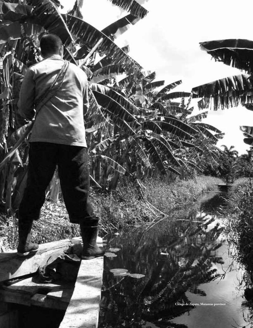
Ciénga de Zapata, Matanzas province
Caribbean Risk Management Initiative32
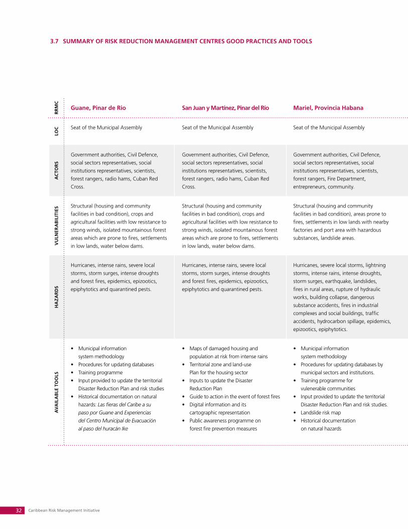
RR
MC
Guane, Pinar de Rio San Juan y Martínez, Pinar del Río Mariel, Provincia Habana Ciénaga de Zapata, Matanzas Santa Cruz del Sur, Camagüey Guamá, Santiago de Cuba
RR
MC
LOC Seat of the Municipal Assembly Seat of the Municipal Assembly Seat of the Municipal Assembly Administrative office of the Municipal
Assembly
Seat of the Municipal Assembly Seat of the Municipal Assembly
LOC
AC
TOR
S
Government authorities, Civil Defence,
social sectors representatives, social
institutions representatives, scientists,
forest rangers, radio hams, Cuban Red
Cross.
Government authorities, Civil Defence,
social sectors representatives, social
institutions representatives, scientists,
forest rangers, radio hams, Cuban Red
Cross.
Government authorities, Civil Defence,
social sectors representatives, social
institutions representatives, scientists,
forest rangers, Fire Department,
entrepreneurs, community.
Government authorities, Civil Defence,
social sectors representatives, social
institutions representatives, scientists,
forest rangers, population, radio hams,
Cuban Red Cross.
Government authorities, Civil Defence,
social sectors representatives, social
institutions representatives, scientists,
population, radio hams, Cuban Red Cross.
Government authorities, Civil Defence,
social sectors representatives, social
institutions representatives, scientists,
Forest rangers, radio hams, community
services, population, Cuban Red Cross.
AC
TOR
S
VU
LNER
AB
ILIT
IES Structural (housing and community
facilities in bad condition), crops and
agricultural facilities with low resistance to
strong winds, isolated mountainous forest
areas which are prone to fires, settlements
in low lands, water below dams.
Structural (housing and community
facilities in bad condition), crops and
agricultural facilities with low resistance to
strong winds, isolated mountainous forest
areas which are prone to fires, settlements
in low lands, water below dams.
Structural (housing and community
facilities in bad condition), areas prone to
fires, settlements in low lands with nearby
factories and port area with hazardous
substances, landslide areas.
Structural (housing and community
facilities in bad condition), isolated forest
areas which are prone to fires, settlements
in low lands.
Structural (housing and community
facilities in bad condition), settlements in
coastal low lands, water below dams.
Structural (housing and community
facilities in bad condition), isolated
mountainous forest areas which are prone
to fires, settlements in low lands, river
terraces.
VU
LNER
AB
ILIT
IES
HA
ZAR
DS
Hurricanes, intense rains, severe local
storms, storm surges, intense droughts
and forest fires, epidemics, epizootics,
epiphytotics and quarantined pests.
Hurricanes, intense rains, severe local
storms, storm surges, intense droughts
and forest fires, epidemics, epizootics,
epiphytotics and quarantined pests.
Hurricanes, severe local storms, lightning
storms, intense rains, intense droughts,
storm surges, earthquake, landslides,
fires in rural areas, rupture of hydraulic
works, building collapse, dangerous
substance accidents, fires in industrial
complexes and social buildings, traffic
accidents, hydrocarbon spillage, epidemics,
epizootics, epiphytotics.
Hurricanes, intense rains, severe local
storms, storm surge, intense droughts
and forest fires, epidemics, epizootics,
epiphytotics and quarantined pests.
Hurricanes, intense rains, severe local
storms, flooding and storm surges,
epidemics, epizootics, epiphytotics, and
quarantined pests.
Hurricanes, intense rains, local storms,
storm surges, earthquakes, intense
droughts and fires in rural areas, traffic
accidents, dangerous substance accidents,
fires in industrial complexes or rupture of
hydraulic works, epidemics, epizootics,
epiphytotics, and quarantined pests.
HA
ZAR
DS
AV
AIL
AB
LE T
OO
LS
Municipal information •
system methodology
Procedures for updating databases •
Training programme•
Input provided to update the territorial •
Disaster Reduction Plan and risk studies
Historical documentation on natural •
hazards: Las fieras del Caribe a su
paso por Guane and Experiencias
del Centro Municipal de Evacuación
al paso del huracán Ike
Maps of damaged housing and •
population at risk from intense rains
Territorial zone and land-use •
Plan for the housing sector
Inputs to update the Disaster •
Reduction Plan
Guide to action in the event of forest fires•
Digital information and its •
cartographic representation
Public awareness programme on •
forest fire prevention measures
Municipal information •
system methodology
Procedures for updating databases by •
municipal sectors and institutions.
Training programme for •
vulenerable communities
Input provided to update the territorial •
Disaster Reduction Plan and risk studies.
Landslide risk map•
Historical documentation •
on natural hazards
Guide to action in the event of forest fires•
Proposal for forest fire observation •
points and necessary equipment
Municipal risk map•
Photographic registry of •
previous disasters
Inputs provided for the municipal •
Disaster Reduction Plan
Methodology and protocols developed •
for the environmental impact studies
Input for incorporating risk •
reduction in the Land Management
and Urbanism Plan
Input provided to the municipal •
Disaster Reduction Plan
Municipal risk map•
Methodology for characterizing risk •
perception in vulnerable communities
Digitalized historical documentation•
Data on the construction state •
of housing and materials
Municipal communication plan•
Training programme for communities •
vulnerable to natural hazards
Maps of municipal evacuation routes•
Input provided to update the Disaster •
Reduction Plan and territorial risk studies
Photographic documentation of the main •
disasters that have affected the region
Project proposals for strengthening •
response capacities of the municipality’s
vulnerable communities
AV
AIL
AB
LE T
OO
LS
3.7 SUMMARy OF RISk REDUCTION MANAGEMENT CENTRES GOOD PRACTICES AND TOOLS
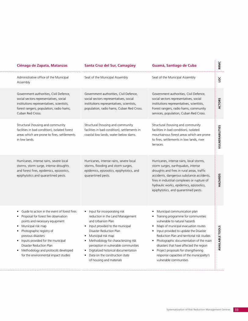
Systematization of Risk Reduction Management Centres 33
RR
MC
Guane, Pinar de Rio San Juan y Martínez, Pinar del Río Mariel, Provincia Habana Ciénaga de Zapata, Matanzas Santa Cruz del Sur, Camagüey Guamá, Santiago de Cuba
RR
MC
LOC Seat of the Municipal Assembly Seat of the Municipal Assembly Seat of the Municipal Assembly Administrative office of the Municipal
Assembly
Seat of the Municipal Assembly Seat of the Municipal Assembly
LOC
AC
TOR
S
Government authorities, Civil Defence,
social sectors representatives, social
institutions representatives, scientists,
forest rangers, radio hams, Cuban Red
Cross.
Government authorities, Civil Defence,
social sectors representatives, social
institutions representatives, scientists,
forest rangers, radio hams, Cuban Red
Cross.
Government authorities, Civil Defence,
social sectors representatives, social
institutions representatives, scientists,
forest rangers, Fire Department,
entrepreneurs, community.
Government authorities, Civil Defence,
social sectors representatives, social
institutions representatives, scientists,
forest rangers, population, radio hams,
Cuban Red Cross.
Government authorities, Civil Defence,
social sectors representatives, social
institutions representatives, scientists,
population, radio hams, Cuban Red Cross.
Government authorities, Civil Defence,
social sectors representatives, social
institutions representatives, scientists,
Forest rangers, radio hams, community
services, population, Cuban Red Cross.
AC
TOR
S
VU
LNER
AB
ILIT
IES Structural (housing and community
facilities in bad condition), crops and
agricultural facilities with low resistance to
strong winds, isolated mountainous forest
areas which are prone to fires, settlements
in low lands, water below dams.
Structural (housing and community
facilities in bad condition), crops and
agricultural facilities with low resistance to
strong winds, isolated mountainous forest
areas which are prone to fires, settlements
in low lands, water below dams.
Structural (housing and community
facilities in bad condition), areas prone to
fires, settlements in low lands with nearby
factories and port area with hazardous
substances, landslide areas.
Structural (housing and community
facilities in bad condition), isolated forest
areas which are prone to fires, settlements
in low lands.
Structural (housing and community
facilities in bad condition), settlements in
coastal low lands, water below dams.
Structural (housing and community
facilities in bad condition), isolated
mountainous forest areas which are prone
to fires, settlements in low lands, river
terraces.
VU
LNER
AB
ILIT
IES
HA
ZAR
DS
Hurricanes, intense rains, severe local
storms, storm surges, intense droughts
and forest fires, epidemics, epizootics,
epiphytotics and quarantined pests.
Hurricanes, intense rains, severe local
storms, storm surges, intense droughts
and forest fires, epidemics, epizootics,
epiphytotics and quarantined pests.
Hurricanes, severe local storms, lightning
storms, intense rains, intense droughts,
storm surges, earthquake, landslides,
fires in rural areas, rupture of hydraulic
works, building collapse, dangerous
substance accidents, fires in industrial
complexes and social buildings, traffic
accidents, hydrocarbon spillage, epidemics,
epizootics, epiphytotics.
Hurricanes, intense rains, severe local
storms, storm surge, intense droughts
and forest fires, epidemics, epizootics,
epiphytotics and quarantined pests.
Hurricanes, intense rains, severe local
storms, flooding and storm surges,
epidemics, epizootics, epiphytotics, and
quarantined pests.
Hurricanes, intense rains, local storms,
storm surges, earthquakes, intense
droughts and fires in rural areas, traffic
accidents, dangerous substance accidents,
fires in industrial complexes or rupture of
hydraulic works, epidemics, epizootics,
epiphytotics, and quarantined pests.
HA
ZAR
DS
AV
AIL
AB
LE T
OO
LS
Municipal information •
system methodology
Procedures for updating databases •
Training programme•
Input provided to update the territorial •
Disaster Reduction Plan and risk studies
Historical documentation on natural •
hazards: Las fieras del Caribe a su
paso por Guane and Experiencias
del Centro Municipal de Evacuación
al paso del huracán Ike
Maps of damaged housing and •
population at risk from intense rains
Territorial zone and land-use •
Plan for the housing sector
Inputs to update the Disaster •
Reduction Plan
Guide to action in the event of forest fires•
Digital information and its •
cartographic representation
Public awareness programme on •
forest fire prevention measures
Municipal information •
system methodology
Procedures for updating databases by •
municipal sectors and institutions.
Training programme for •
vulenerable communities
Input provided to update the territorial •
Disaster Reduction Plan and risk studies.
Landslide risk map•
Historical documentation •
on natural hazards
Guide to action in the event of forest fires•
Proposal for forest fire observation •
points and necessary equipment
Municipal risk map•
Photographic registry of •
previous disasters
Inputs provided for the municipal •
Disaster Reduction Plan
Methodology and protocols developed •
for the environmental impact studies
Input for incorporating risk •
reduction in the Land Management
and Urbanism Plan
Input provided to the municipal •
Disaster Reduction Plan
Municipal risk map•
Methodology for characterizing risk •
perception in vulnerable communities
Digitalized historical documentation•
Data on the construction state •
of housing and materials
Municipal communication plan•
Training programme for communities •
vulnerable to natural hazards
Maps of municipal evacuation routes•
Input provided to update the Disaster •
Reduction Plan and territorial risk studies
Photographic documentation of the main •
disasters that have affected the region
Project proposals for strengthening •
response capacities of the municipality’s
vulnerable communities
AV
AIL
AB
LE T
OO
LS

Caribbean Risk Management Initiative34
4. Sustainability of Risk Reduction Management Centres
The Cuban Government is committed to the continuity of the Risk Reduction Management Centres
(RRMC) as a response to the Civil Defence System’s strategy to make available this model to all munici-
palities in the country, starting with the most vulnerable. The legal corpus developed and the actions
undertaken confirm this commitment. The RRMCs can count on technical and financial support from the
United Nations, as stated in the 2008 - 2012 United Nations Development Assistance Framework (UN-
DAF), and from other international cooperation agencies present in Cuba. This by itself, however, does
not guarantee the sustainability of the model.
Sustainability of the RRMCs implies changes in work methodology and strengthening of local gov-
ernment capacities. This is achieved through the creation of permanent centres with suitable levels of
technical and structural support, allowing for adequate information management for decision-making in
development processes, investment projects, and disaster risk management, to be carried out by govern-
ment with full community participation.
Local governments, entities, social institutions, the community and beneficiary families are com-
mitted to the RRMC model and have assumed responsibility for the maintenance and management of
acquired infrastructure and equipment. The government assumes salary and operating costs as well as
the maintenance and repair of infrastructure and equipment.
The majority of risk reduction actions carried out by the centres have had a much lower economic
cost than the costs that would result from the impact of a hazard not anticipated in local development
plans. In addition to this and other social benefits, the Cuban experience demonstrates the willingness
of the country to invest resources and actions to protect or safeguard its population when faced by any
kind of disaster risk.
4.1 WHAT RESULTS AND TOOLS HAVE THE CENTRES GENERATED?
The centres have increased efficiency in implementing the activities directed at disaster risk reduction
and have imparted the technical resources necessary for the decision-making processes in local gov-
ernments, with a broader participatory base of sectors, institutions and the community. The effective
analysis of information received and distributed takes into consideration the majority of interests in the
locality. It should be pointed out that all sectors and institutions are legally obligated to systematically
contribute and update information from their area. Transparency and objectivity in decision-making is
observed in the updated information received from throughout the region; this tendency extends to
diverse development processes including those linked to disaster risk reduction.
In the case of a disaster hazard, the personnel, resources and means of the centres support Defence
Councils activated at different levels. The RRMCs provide complementary information to that of ter-
ritorial risk reduction plans, facilitate analyses and decision-making, and document all actions that are
To ensure the sustainability of the centres beyond the life of the project, it is necessary to demonstrate that the social, economic and environmental benefits they provide compensate for the costs involved in their creation, development and operation.
Systematization of Risk Reduction Management Centres 35
developed in response and recovery phases in the territory. This historical documentation constitutes
a valuable source of information that is fed back and used to perfect the territory’s disaster reduction
plans and disaster risk studies.
4.2 THE CENTRES HAVE REINFORCED PREPARATION AND COMMUNICATION EFFORTS IN
DISASTER RISk REDUCTION
In preparedness and dissemination:
By having at their disposition available data bases and didactic materials developed by different enti-•
ties and institutions, the RRMCs have enhanced the public awareiness campaign preparation and
dissemination of Civil Defence measures.
The knowledge of local authorities, technicians, staff members and the population in general is •
increased due to systematic workshops, exchanges and trainings. With the creation of the first
Risk Reduction Management Centre, a regional cycle of workshops was established to disseminate
and share the RRMC experience. Local authorities, directors and specialists in risk reduction man-
agement, and representatives of the United Nations System and international non-governmental
organizations have participated in these workshops.
In communications:
The existing communication resources in the territory have been reinforced with the RRMC equip-•
ment, thus enabling better transmission of voice, data and images to different administrative levels
and reducing “silent zones”. Vulnerable communities are able to maintain radio communication be-
tween several of its members; this helps with the execution of established Civil Defence measures.
The RRMCs provide alternative points for transmitting data, radio and local television. The func-•
tions carried out by the centres and their vitality in disaster situations has allowed them to transmit
specific information in real time as well as informing the population of the measures and norms to
follow to protect their lives and safeguard their belongings.
Among the tools that the RRMCs have generated are:
The legal, methodological and organizational framework that guides their operation•
A Guide for conducting risk studies and a Methodology for risk assessment•
Geographic Information Systems•
Thematic data bases and disaster reduction plans•
Early Warning Systems, including Early Warning Points•
Inputs to incorporate into territorial disaster risk reduction plans•
Educational campaigns; didactic and preparatory materials•
Training processes and local, national and regional knowledge exchange•
These detailed actions, topics and contingency plans have grown through a process of exchange of experiences, knowledge and cooperation between the principal and diverse actors of regional risk reduction.
Caribbean Risk Management Initiative36
4.3 LESSONS LEARNED
The Risk Reduction Management Centres (RRMC) in Cuba respond to a pragmatic medium- and long-
term vision and priority. They are designed to resolve problems perceived by the leading risk reduction
institution, the Joint Staff of National Civil Defence, and local governments, which provide the political
will necessary for the implementation, development and sustainability of the Centres.
As a result of this systematization process on the RRMCs, authorities, technicians and the population
in general have identified lessons learned that are directly linked to the development and functioning
of these centres. They are as follows:
The country, the Civil Defence System and local governments are organized and possess a legal •
framework, disaster risk reduction plans, institutional capacity and human resources to develop
actions for risk reduction in different territories. It is within this context that Risk Reduction Manage-
ment Centres are inserted, facilitating the work of local governments, and in particular the decision-
making process regarding disaster risk. Based on these experiences, local governments have
extended their use of the centres to other decision-making processes within their juris-
diction, including planning and resource management for development and investment
projects.
Each local government and community faces a reality and scenario of different risks, and will pon-•
der their actions based on their capacities, strengths, available resources and weaknesses. One of
the most important lessons that these centres have contributed is that local governments
have identified their own strategies in accordance with the existing legal framework and
have created various tools for incorporating risk reduction in development processes and
investment projects.
Although the centres constitute a working tool of the government and Civil Defence, participat-•
ing institutions, entities and communities have assumed ownership of the management
processes allowing greater harmonization of disaster risk reduction planning in the
territories.
RRMCs and EWPs evolved in different and complementary contexts. The first on an institutional, •
strategic and informational level linked to decision-making processes; the second in the communi-
ties where hazards exist, linked to response actions. Governments have correctly identified that
the number of EWPs in their territory should respond not only to an analysis of the pos-
sibilities and financial decisions within a project, but must be determined by conditions of
vulnerability and population exposure to disaster risk.
Technological support for information and communications within the RRMCs and EWPs should be •
appropriate to the technical conditions and financial realities of the territories, and allow for connec-
tivity to the principle networks of information, data and image transmission, among other things.
This allows governments and defence councils to be able to access, in real time, available
information about the evolution of a hazard. Based on this, they then can adopt measures
for the protection of the population, such as evacuation, when faced with hurricanes and
intense rains, in accordance with the disaster risk reduction plan.

Systematization of Risk Reduction Management Centres 37
BEST PRACTICES LESSONS LEARNED
INFO
RM
ATI
ON
Municipal information system for risk reduc-tion.
Preparation and updating of digital data bases in the interest of risk reduction.
Geographic information system for risk reduc-tion.
The effectiveness of using the developed methodology and info-communications in other decision-making areas which fall under government jurisdiction, including planning and resource management for development and investment projects.
PLA
NN
ING
Updating the municipality’s General Plan for Land Management and Urbanism.
Preparation of Disaster Reduction Plan for for-est fires.
Development of technological capacities for Municipal Defence Command Post.
The need for governments to identify their own strategies in accordance with the existing legal framework, and to create different tools for incorporating risk reduction in the devel-opment processes and investment projects be-ing implemented at the local level.
MU
LTID
ISC
IPLI
NA
Ry
ASP
ECTS
Identification, promotion, and participation with other sectors and institutions, in local pre-paredness and training projects for disaster risk reduction.
The need for different participating institu-tions, entities and communities to assume ownership of management processes, ena-bling a consolidation in the overall work be-ing developed to reduce the risk of disasters in their territories.
AN
ALy
SIS
AN
D R
ISk
Completion of a disaster risk study at the ter-ritorial and urban scale.
Completion of a disaster risk study in hydro-graphical watersheds.
Integration of the results of different risk stud-ies of natural and technological hazards.
The importance of disaster risk studies for de-cision-making in recovery and reconstruction processes, and strategic development, includ-ing sectoral investment plans.
CA
PAC
ITy
DEV
ELO
PMEN
T
Training in vulnerable communities.
Preparation of a training programme in disas-ter risk reduction for personnel from municipal health and education sectors.
Training of officials from health, housing, phys-ical planning and education sectors, political and mass organizations, and enterprises and economic entities.
The importance of training processes for the population, and the education of human re-sources at different levels on topics of risk management. This has the capacity to trans-form the causes of disasters.
The following table presents a summary of the best practices and lessons learned associated with the
RRMCs, based on the most relevant aspects to their operation and sustainability:
Caribbean Risk Management Initiative38
4.4 DEVELOPMENT OF RISk REDUCTION MANAGEMENT CENTRES IN OTHER COUNTRIES
AND CONTEXTS OF THE REGION
Can the Cuban experience with Risk Reduction Management Centres be developed or reproduced in
other countries and contexts? The response is affirmative. RRMCs, or any other tool dedicated to the
same purpose, must respond to pragmatic medium and long-term visions and priorities. They must be
designed to address and resolve problems perceived by governments at different levels, as this builds
the political will to implement, develop and continue the model over time.
Elements of the Cuban experience with RRMCs that should be taken into account in the replication
of this experience:
Beyond political will and the legal framework that guarantees action, the centres require qualified •
human resources. In Cuba, investment is made in the development of human capital, and without a
doubt, this constitutes a strength that guarantees the process.
RRMCs in Cuba have been designed with the objective of providing relevant information for deci-•
sion-making, through simple, participatory and up-to-date methodological tools. The technology
for obtaining, processing, using or spreading information must be selected according to the social
and economic reality of each territory or country.
To develop a RRMC in any given context, the existence of institutions or other organizational forms •
that are linked to development processes, land-use planning and risk reduction is critical and de-
cisive. These organizations must have the capacity to obtain information and the commitment to
share it.
The majority of national governments in the region have expressed their commitment to prioritize
action in the field of disaster reduction. These governments are supported by different internation-
al cooperation organizations. Although political support alone should guarantee the success of this
tool, the international collaborators should respond if, in fact, risk reduction forms part of the work
agenda of national and, in particular, local governments. This is especially the case if the international
collaborater´s influence allows them to incorporate disaster risk reduction into development processes
and investment projects in the territory.
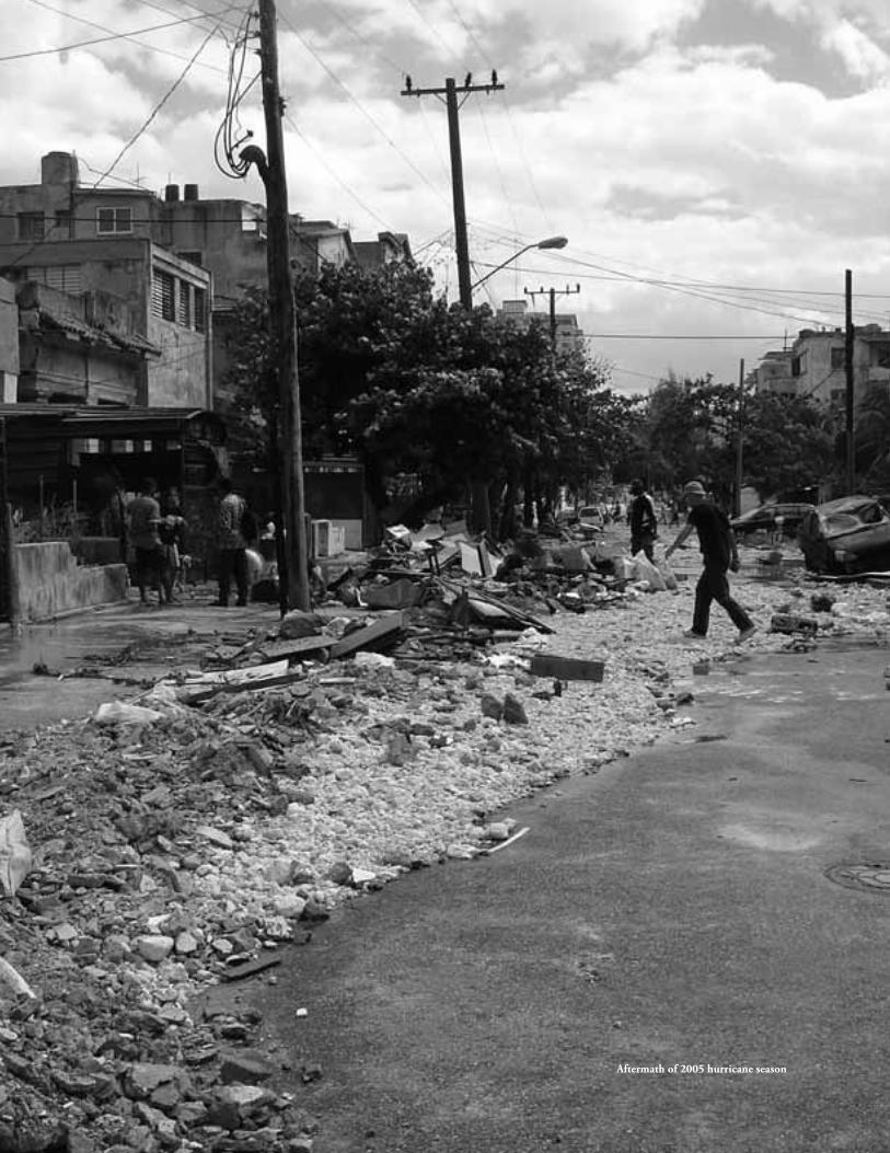
Aftermath of 2005 hurricane season
Caribbean Risk Management Initiative40
Annexes
The following annexes are examples of the type of information handled by the Risk Reduction Manage-
ment Centres (RRMC). They include risk study samples, geographically-referenced imagery, control and
resource organization charts and informational material aimed at raising population's awareness about
risks. Also included are a reflection about the RRMC experience, and the CPAP's expected outcomes
related to disaster risk reduction in Cuba.
It is our hope that these annexes contribute to a better understanding of the RRMC's functioning con-
text, and its relevance as a key element for disaster risk reduction and improvement of quality of life in
local communities.
Systematization of Risk Reduction Management Centres 41
A. EXAMPLE: TABLE OF CONTENTS, GUIDE TO CONDUCTING A DISASTER RISk STUDy
INTRODUCTION
GENERAL OUTLINESLegal BaseObjectives of the Guide and Disaster Risk StudiesProceduresGeneral Aspects about Risk Management
RISK OR HAZARD STUDIESStudies of Hazards of Natural Origen Studies of Hazards of Technological Origen Studies of Health HazardsConclusionsRecommendations from Hazards Studies
VULNERABILITY STUDIESGeneral Analysis of Physical Vulnerability Conclusions Recommendations from Vulnerability Study
RISK ASSESSMENT Risk AssessmentCost Benefit Analysis
OUTPUT OF RISK STUDIESGeneral AspectsSpecificities by type of risk study
Natural Risks Study Technological Risks StudyHealth Risks Study

Caribbean Risk Management Initiative42
B. EXAMPLE: DISASTER RISk STUDy AT THE TERRITORIAL AND URBAN SCALE: CIéNAGA
DE ZAPATA
Introduction Located in the south of Matanzas province, Ciénaga de Zapata occupies an area of 520,000 hectares. It is bound-
ed by Jagüey Grande Municipality to the North, Cienfuegos Province to the East, Unión de Reyes Municipality to the West and the Caribbean Sea to the South. This wetland, the largest in the Caribbean, includes 228,224 hectares of forest area and 147,976 hectares of swampy area. It also has 184 kilometres of coastline, with Bahía de Cochinos and Ensenada de la Broa standing out as the main geographical features. Because of its biodiversity, it is an important natural region, as much for its flora as for its fauna and the water resources it contains. For these reasons the Cuban State, through Decree-Law 197, declared it a Special Region for Sustainable Development and UNESCO granted it the category of Biosphere Reserve (2000). Likewise the Ramsar Convention on Wetlands granted it the category of Ramsar Site (2001), for being a Wetland of International Importance.
At present, Cuba is applying for the category of World Natural Heritage for this region. Obtaining it would make the Ciénaga one of the few natural areas of the world having such high recognition, where natural wealth and its endemism, uniqueness of various species, history, culture and the degree of conservation that it presents, all pre-dominate.
Basic economic activities in the region are silviculture, ecotourism, fishing (shelf and reservoir), beekeeping and, on a lesser scale, handicrafts.
The Forestry Enterprise has a land holding equivalent to 477,774 hectares. It is the largest of its type in the coun-try. Ecotourism, based on the variety of the region’s landscapes, trails, fishing and other offers, makes a contribution to the economy of between $9-11 million annually. Fishing has a capture plan of 800-1,000 metric tons/year. During the flowering season beekeeping, with 12-14,000 colonies, harvests between 500-700 metric tons of honey and other high-value added products such as wax, propolis and propoline.
From the hydraulic viewpoint, the Hatiguanico, Salado and the Rice-Growing Plan Magistral Canal flow into our municipality. It also receives the discharge from all the province’s southern springs, yielding a fresh water reserve in Laguna del Tesoro.
The population of our municipality is 8,821 inhabitants of whom 5,696 are urban residents and 3,125 are rural, with an overall population density of 2 inhabitants/km2. They are distributed in 19 population settlements.
The main roadways are:
• PlayaLarga–JagüeyGrandeRoad• PlayaLarga-Girón–AguadadePasajerosRoad• PlayaLarga–SoplillarRoad• Improvedroadsare: Buenaventura – Santo Tomás – Vínculo Playa Girón – Guasasa – Cocodrilo Hondones – Cayo Ramona Hondones – Rice-growing Plan – National Highway Palpite – Soplillar – Hondones
Systematization of Risk Reduction Management Centres 43
System for producing electricity
The territory has a 33 kW sub-transmission network which is fed by the Jagüey Grande 110 kW substation. Three substations are located in the towns of Palpite, Playa Larga and Playa Girón from which 13 kW enters the distribution network.
Water supply
The territory’s water supply is provided through 4 Pumping Stations located in San Isidro, Playa Girón (El Peaje), Cayo Ramona and Guasasa. These supply more than 75% of the municipal population. The remainder is supplied with water from tank trucks and wells.
The state of buildings:
The predominant constructions in the municipality are 1 and 2 stories. In the town of Playa Girón there are 2 buildings with 4 stories. Overall, the most numerous buildings are of wood with light roofs. However, because of the vulnerability of these roofs and as a result of the passage of Hurricane Michelle, the municipal housing stock later improved considerably with canted constructions and blocks.
Each year, the region is threatened by different meteorological events and by those of a technological origin. This puts the stability and natural resources of the Wetland at risk, as well as the housing and administrative infrastructure created by the Revolution.
The accumulated experience of previous and present generations facilitates preventive conditions to minimize such high risks. It prevents the loss of human lives as the priority, as well as the significant economic damages caused by hurricanes, and impacts from a technological or human origin.
In a summary form, we are going to show the magnitude of the risks to which we are exposed in the Ciénaga de Zapata, their scale, and the possibilities to decrease and even prevent some of them. Risk prevention requires a preven-tive warning system that is guaranteed and appropriate to each situation. Many of the values and figures that we show are based on meteorological and technological events and from the noted effect of anthropogenic actions.
The Zapata region can be affected by: 1. High intensity hurricanes2. Storms3. Intense rains and inundations4. Intense droughts5. Naturally-occurring fires and fires produced through human action6. The Girón international air corridor7. Pests and foreign diseases8. Sea penetrations9. Hydrocarbon spillage
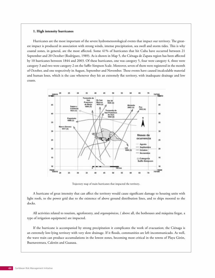
Caribbean Risk Management Initiative44
1. High intensity hurricanes Hurricanes are the most important of the severe hydrometeorological events that impact our territory. The great-
est impact is produced in association with strong winds, intense precipitation, sea swell and storm tides. This is why coastal zones, in general, are the most affected. Some 41% of hurricanes that hit Cuba have occurred between 21 September and 20 October (Rodríguez, 1989). As is shown in Map 5, the Ciénaga de Zapata region has been affected by 10 hurricanes between 1844 and 2003. Of these hurricanes, one was category 5, four were category 4, three were category 3 and two were category 2 on the Saffir-Simpson Scale. Moreover, seven of them were registered in the month of October, and one respectively in August, September and November. These events have caused incalculable material and human loses, which is the case whenever they hit an extremely flat territory, with inadequate drainage and low coasts.
Trajectory map of main hurricanes that impacted the territory.
A hurricane of great intensity that can affect the territory would cause significant damage to housing units with light roofs, to the power grid due to the existence of above ground distribution lines, and to ships moored to the docks.
All activities related to tourism, agroforestry, and organopónicos, ( above all, the hothouses and máquina fregat, a type of irrigation equipment) are impacted.
If the hurricane is accompanied by strong precipitation it complicates the work of evacuation; the Ciénaga is an extremely low-lying territory with very slow drainage. If it floods, communities are left incommunicado. As well, the wave train can produce accumulations in the lowest zones, becoming most critical in the towns of Playa Girón, Buenaventura, Caletón and Guasasa.
Systematization of Risk Reduction Management Centres 45
Hurricane Michelle (Category 4) caused the following impact:
Areas affected Areas damaged Volume affected Volume recovered Recovery time Observations
EMA V.G. 100,000 hectares 4 billion cubic metres
1,620,000 cubic metres
4 years Totally damaged 51 hectares of urban area
Beekeeping 100,000 hectares 700 metric tons/year
650 metric tons 4 years 2002 without pro-duction
Fishing Shelf and Capture 541 metric tons 459 metric tons 4 years Capture decreased by over 50%
Housing Roofs and totally destroyed
1,678 and 1,270 1,678 and 1,270 4 years At present 50% would be affected ($19,957,000)
INRH (water re-sources)
Population 6,050 people Total 2 years
Commerce and Gastronomy
16 and 19 units 16 and 19 16 and 19 3,5 years
EMP. Services Roofs and shutters Total Total 3 years Would affect $2,730
2. High intensity storms
The annual incidence of severe local storms increases from the coast to the north, corresponding to the distribu-tion of genetic squall zones associated with wind convergence zones. These short-lived but great intensity events are significant in the northern region. They occur in every period, mainly at the start of the season (May-June) and extend until October.
In the first case, they are usually electric storms and many times tend to cause fires in areas where lands are covered in peat. This has a severe impact for ecosystems corresponding to grasslands. They can also affect forest areas. When these storms are accompanied by strong rains, sea penetrations occur in areas near the coast, above all in the communi-ties of Guasasa, Girón, Playa Larga, Caletón and Buena Ventura.
3. Flooding
The region is also affected by inundations in areas corresponding to the communities of Cocodrilo, Guasasa, Girón, El Rincón, La Ceiba, San Blas, Helechal, Cayo Ramona, Girón, Los Hondones, Soplillar, Palpite, Playa Larga, Mario López, Caletón, Buena Ventura, Santo Tomás and El Vínculo. Some years ago, when precipitation levels ex-ceeded 1,500 mm annually, various communities were flooded for months. This limited all productive activities and services for the population, and eventually increased the risks of an outbreak of acute diarrheal and other diseases.
4. Intense droughts
Over the last 20 years, precipitation levels have been decreasing considerably. Rainfall levels were between an all-time high of 1,400-1,700 mm annually (from May until October). In the last decade, however, rainfalls have dwindled
Caribbean Risk Management Initiative46
significantly. In the last two years, they did not surpass 541 mm, less than a third of the all-time highs.
Connected to this is water leakage from the Ciénaga to the sea, due to the lack of completion of a group of hydraulic works which became paralyzed because of the arrival of the Special Period. Among these is the Soplillar-Hondones bridge floodgate system, culvert #24 (in front of the La Boca Complex) and periodic cleaning of some canals. This situation causes the annual loss of 34 to 42 million cubic metres of water. If this water had been retained, it could have reached the forest areas and maintained the moisture, thereby preventing huge forest fires and the enor-mous economic and ecological damage that the wetland forest heritage is experiencing.
5. Naturally-occurring fires and fires produced through human action Each year areas with peat in their soil are subjected to intense drought and then ignite as a result of high tem-
peratures, and burn up. The same thing happens from electrical discharges or lightening. Both are naturally-occurring fires. Many other fires occur; the most dangerous is because of human intervention. This can be because of furtive activity such as capturing and cooking turtles, burning to ward off a plague of mosquitoes and sand flies, smoking in the outdoors, and/or not using ashtrays or measures to control the sparks. This result is a loss of thousands of hectares of forest each year
6. The Girón International air corridor
The Ciénaga de Zapata region is crossed by the Girón International air corridor through which hundreds of airplanes pass each year. On the one hand, there are risks of a plane going down and the resulting consequences this brings. On the other hand, this is a route that the enemy might use to penetrate and spread foreign pests and diseases which could cause serious damage and consequences for the population as well as for the economy. It is sufficient to point to the entrance of Thrips palmi to Cuba. It caused great damage in the early years of the Special Period to more than 100 species of cultivated plants, which were the main food sources sustaining the population in the highly dif-ficult times after the collapse of the socialist camp.
Also arriving at our coast are drugs, which put at risk very susceptible segments of the population such as youth. Thanks to the coastal brigades this has not produced greater repercussions.
7. Pests and diseases With 180 km. of coastline exposed to sea currents carrying different contaminants, Ciénaga de Zapata faces high
risks from pests and diseases. These can cost human lives, and affect animals and crops with significant losses for the national economy.
Among these risks are the following:
1. The existence of the international air corridor. 2. The existence of migratory birds, originating from the North American continent.
Systematization of Risk Reduction Management Centres 47
3. The existence of vector species that transmit disease. 4. North American and other visitors who introduce diseases and pests such as West Nile Fever, aphthous
fever and screwworm.
8. Sea penetrations
Because of strong storms, great intensity hurricanes in the Caribbean area or an extratropical low, the sea level can rise and entire low areas of the coastland become flooded. This affects several communities located in the coastal zone, their entire infrastructure and population of 1,183 inhabitants.
9. Hydrocarbon spillage
The territory has several points for possible hydrocarbon spillage: La Boca, on the borderline with Laguna del Tesoro, which has a retail fuel pump for tourism and watercraft (with 10,000 litres of fuel), and; René Ramos Latour Fishing Cooperative in Caleta Sábalo, which has the 36,000 litre fuel tank. The possibility of a maritime accident in-volving supertankers transporting fuel by the southern Caribbean Sea cannot be discarded. Because of ocean currents, spilled fuel could arrive on our coasts, with serious consequences for the wetland environment.
Vulnerability
The Ciénaga de Zapata region presents high risks from the effects of natural phenomena, as well as from those of technological origin.
As a consequence of the flooding produced in the lower stretch of the Hanábana River from Hurricanes Kate, Lili, Irene, Michelle, it was necessary to carry out a new hydrological study to specify maximum costs of different project possibilities for modifying the existing Soplillar Chute.
The Soplillar Canal was conceived of in 1959 with the objective of drawing runoffs from the Hanábana River.
Formerly, these runoffs emptied into the Hatiguanico River (Laguna Tesoro) towards the sea, without causing large inundations in the areas proposed for reclamation for agricultural use through the Polders system. At the same time this canal would intake waters produced from the pumping and drainage of the above-mentioned areas. This canal, in its centre and lower stretch, has a gradient height less than zero. Engineering, geological and hydrogeological condi-tions encourage drainage of subterranean waters from Zone B to the canal. The penetration of sea water inland also goes through the same watercourse. Thus, in the above-mentioned project, a budget was provided for the construction of a control chute which would have the following main objectives:
1. Prevent sea water penetration inland, through the watercourse, to the Eastern Ciénaga, which would result in an ecological disaster in the territory.
Caribbean Risk Management Initiative48
2. Change the flood course of the Hanábana River during unusual water events, which avoids rapid drainage towards the sea.
3. Guarenteed the gravity feed drainage for the waters pumped from Polders and from the Hanábana River to-wards Bahía de Cochinos.
4. Control subterranean water drainage from the southern watershed.
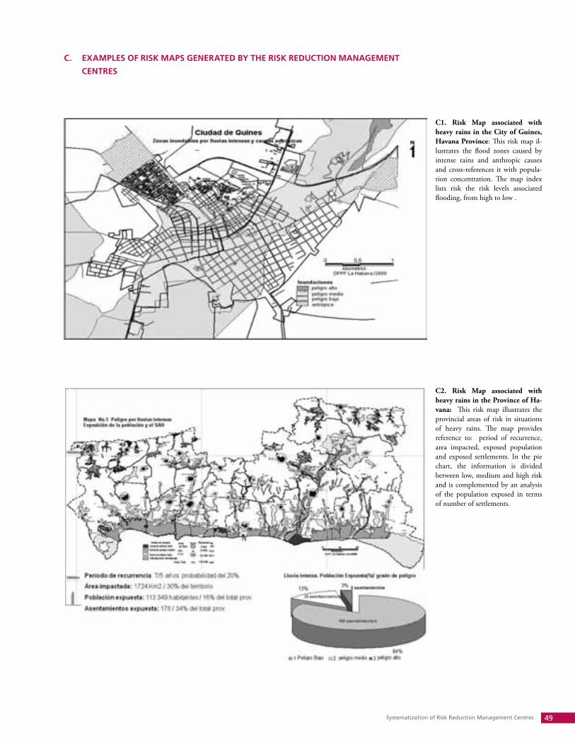
Systematization of Risk Reduction Management Centres 49
C. EXAMPLES OF RISk MAPS GENERATED By THE RISk REDUCTION MANAGEMENT
CENTRES
C2. Risk Map associated with heavy rains in the Province of Ha-vana: This risk map illustrates the provincial areas of risk in situations of heavy rains. The map provides reference to: period of recurrence, area impacted, exposed population and exposed settlements. In the pie chart, the information is divided between low, medium and high risk and is complemented by an analysis of the population exposed in terms of number of settlements.
C1. Risk Map associated with heavy rains in the City of Guines, Havana Province: This risk map il-lustrates the flood zones caused by intense rains and anthropic causes and cross-references it with popula-tion concentration. The map index lists risk the risk levels associated flooding, from high to low .
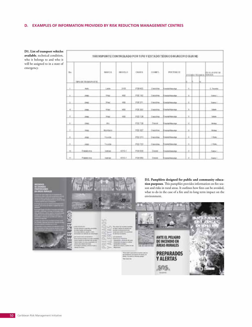
Caribbean Risk Management Initiative50
D. EXAMPLES OF INFORMATION PROVIDED By RISk REDUCTION MANAGEMENT CENTRES
D1. List of transport vehicles available, technical condition, who it belongs to and who it will be assigned to in a state of emergency.
D2. Pamphlets designed for public and community educa-tion purposes. This pamphlet provides information on fire sea-son and risks in rural areas. It outlines how fires can be avoided, what to do in the case of a fire and its long term impact on the environment.
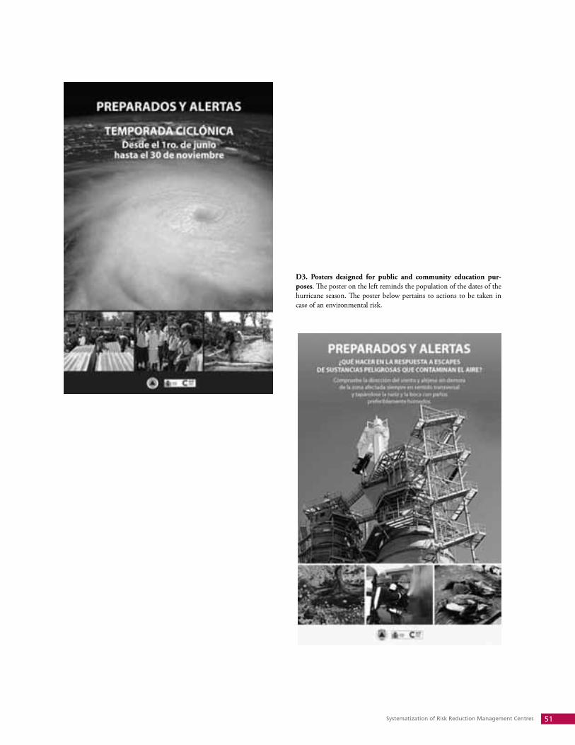
Systematization of Risk Reduction Management Centres 51
D3. Posters designed for public and community education pur-poses. The poster on the left reminds the population of the dates of the hurricane season. The poster below pertains to actions to be taken in case of an environmental risk.
Caribbean Risk Management Initiative52
E. REFLECTIONS ABOUT RISk REDUCTION MANAGEMENT CENTRES
Risk Reduction Management Centres:Experiences in Eastern HolguínBy Cleanel Ricardo Tamayo
Since remote times, the essentials of the story of hydrometeorological events have been written about Eastern Holguín, a province in eastern Cuba. Predictions or realities coming from that rich strip saturated with nickel, born in very ruddy Moa and reaching to Mayarí, where the important mineral is also extracted and processed, inspire fear.
One knows that these natural events are particularly cruel there, among other reasons because Eastern Holguín also carries the weight of the province’s mountainous zone, marked by much more notable annual rainfalls, and grooved by powerful rivers that give life with as much force as they use in the attempt to make it disappear.
That is how it has always been, in an extensive area made up of four municipalities of the present-day province, until the 20th century brought, among its indisputable innovations, the development of the nickel industry. Sur-rounding this industry are dangers that were always known, although perhaps without an adequate appraisal of the real risks, such as those that, because of ignorance or inadequate judgement, become the accidental event for a regrettable disaster.
The Risk Reduction Management Centre (RRMC), with its risk and vulnerabilities studies, helps provide a more comprehensive focus about the realities of Eastern Holguín. This tool facilitates a continuity of work to evaluate and monitor with precision the why and wherefore of cause and effect categories, independently of whether the analyzed event is of a natural, technological or health origin.
Sagua de Tánamo Municipality
Cut through by the Sagua River, one of the largest in Holguín which is born in the province’s mountainous area, Sagua de Tánamo municipality has, aside from the well-known risk of hurricanes that affects the entire country, an additional risk from flooding because of intense rains that originate even further beyond its territorial borders.
It is known that hurricanes and intense rains can cause considerable damage in the thirteen zones or population settlements in Sagua de Tánamo, where building construction, mostly those of wood, are on slopes that make them vulnerable to these events, no matter what their category.
The monitoring and early warning system, which includes seven points with radio plants and rain gauges, and in four of these a scale system in the rivers, works to provide timely warning to the Municipal Defence Council (CDM). At the level of the Hydraulic Resources Office, a computer processes information about the rise in water levels and their time of arrival into the municipality, which allows authorities to take accurate measures to protect people and the economy.
So that the alert works well, a system was created that allows communicating the approaching risk to the CDM, Work Groups, Zonal Defence Councils (CDZ, for its Spanish acronym) and the population, using, in addition to the technical means of the communications system, the local radio station Ecos de Sagua, and cars with loudspeakers and megaphones, always with the participation of political and mass organizations.
With mutual relations of cooperation, one can count on the use of lifesaving resources and rescue equipment requested from neighbouring municipalities. If the event occurs when students are working in the Field Camp, sur-veillance is maintained over the encampments at risk of being incommunicado and they are demobilized according to

Systematization of Risk Reduction Management Centres 53
orders set down by provincial authorities.In calm periods, one knows how many people must participate in the mobilization to protect people and eco-
nomic means and to consolidate administrative agencies, the quantity of vehicles required to carry out these move-ments, and even the number and exact location of the shelters that must receive those evacuated. It is an organized way to considerably reduce human and economic losses when faced with the impact of foreseeable natural hazard, with the preparation of regulations and the establishment of phases for state agencies and organizations, economic entities, social institutions and the territorial population, in a way that guarantees risk impact reduction, while promoting a true culture of prevention.
Mayarí Municipality
In Nicaro, a locality in Mayarí municipal-ity, a nickel-cobalt processing plant has been operating since 1943. It has been dumping, in its proximities, solid wastes in the form of dust, referred to as tailings which are stored in dams that, nowadays, are necessary to monitor at-tentively so as to prevent, to the greatest length possible, negative effects to the area’s coastal and marine ecosystems.
For a long period, the situation of the old tailings dam of Nicaro constituted a disaster haz-ard for the Arroyo Blanco inlet, and caused con-siderable impact on the population, with black-ish dust carried by strong winds that prevailed from March to September.
Studies by enterprises, specialized agencies and the RRMC multidisciplinary group, all at the direction of the Mayarí municipal authorities, allowed them to conclude that the tailings dam is a key contaminant for the surrounding ecosystems and people vulnerable to dust emissions. Therefore, it is essential to correct this situation through technical solutions.
They analyzed the possibilities of covering the entire dust-emitting area of tailings with another type of material that could develop into suitable vegetation, improving the dikes and using more adequately the tailings dam through its division into sections.
To counterbalance dust emissions, it was decided to cover the emitting area, which is some 365 hectares, with a 30 centimetre layer of carbonated material that still allows the development of suitable vegetation. At the same time, it was confirmed that pollution of Arroyo Blanco bay has been resolved through the establishment and reforestation of dikes, levelling the ditches and constructing terraces on the slopes of the dam’s basin up to the East banks.
By breaking up the active tailing dam into sections, which would make five micro-reservoirs with a useful life of five years each, it would be possible to obtain increased storage capacity for tailings for an additional twelve years of the industry’s operation, eliminating atmospheric pollution and spillage of the tailing to the detriment of the area’s coastal and marine ecosystems.
Pollution from tails in Nicaro has impacted marine and coastal ecosystems
Caribbean Risk Management Initiative54
The previous measures, which perhaps appear small or debatable, would eliminate dust emissions into the atmos-phere (increasing air quality), significantly reduce surface hydric erosion to decrease breakdowns of the dikes and pre-vent the escape of tails into the inlet, and in the long run, improve three details: the quality of water that empties into the inlet, the landscape of the surroundings with their flora and fauna, and the conditions of life for the inhabitants of Nicaro, Mayarí and other nearby population centres. In other words, the essentials. To take care of human health, the flora, the fauna and the life of the planet.
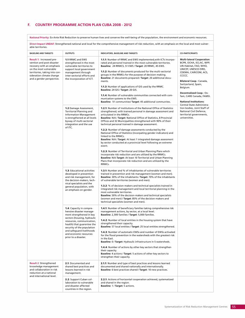
Systematization of Risk Reduction Management Centres 55
F. COUNTRy PROGRAMME ACTION PLAN CUBA 2008 - 2012
National Priority: Ex-Ante Risk Reduction to preserve human lives and conserve the well-being of the population, the environment and economic resources.
Direct Impact UNDAF: Strengthened national and local for the comprehensive management of risk reduction, with an emphasis on the local and most vulner-able territories.
BASELINE AND TARGETS OUTPUTS INDICATORS, BASELINE AND TARGETS CO-PARTICIPANTS
Result 1: Increased pre-vention and post-disaster recovery with an emphasis on the most vulnerable territories, taking into con-sideration climate change and a gender perspective.
1.1 RRMC and EWS strengthened in the most vulnerable territories to support local government management through inter-sectorial efforts and the incorporation of ICT.
1.1.1: Number of RRMC and EWS implemented,with ICTs incorpo-rated and personel trained in the most vulnerable territories. Baseline: 24 RRMCS, 51 EWS / Target: 20 RRMC, 45 EWS.
1.1.2: Number of documents produced for the multi-sectorial groups in the RRMCs for the purpose of decision-making. Baseline: 21 documents prepared / Target: 20 additional docu-ments.
1.1.3: Number of applications of GIS used by the RRMC. Baseline: 24 GIS / Target: 20 GIS.
1.1.4: Number of vulnerable communities connected with com-munication systems to the EWS. Baseline: 51 communities/ Target: 45 additional communites.
Multi-lateral Cooperation: BCPR, OCHA, ECLAC, WFP, UN-Habitat, FAO, WHO, UNICEF, UNESCO EIRD, CDEMA, CARICOM, ACS, CCCCC.
Bilateral Coop.: Canada, Switzerland, Spain, Belgium.
Decentralized Coop.: Ox-fam, CARE Canada, FAMSI.
National Institutions: Central State Administra-tion bodies, Joint Staff of National Civil Defence, territorial governments, universities.
1.2 Damage Assessment, Territorial Planning and Information Management is strengthened at all levels byway of multi-sectorial integration and the use of ITC.
1.2.1: Number of institutions of the National Office of Statistics strengthened, with trained personal in damage assessment and articulated in the RRMCs. Baseline: N/A / Target: National Office of Statistics, 8 Provincial Offices and 32 Municipalities strengthened with 90% of their technical personal trained in damage assessment.
1.2.2: Number of damage assessments conducted by the National Office of Statistics (incorpating gender indicators) and linked to the RRMCs. Baseline: N/A / Target: At least 1 integrated damage assessment by sector conducted at a provincial level following an extreme event.
1.2.3: Number of Territorial and Urban Planning Plans which incorporate risk reduction and are utilized by the RRMCs. Baseline: N/A Target: At least 10 Territorial and Urban Planning Plans that incorporate risk reduction and are utilized by the RRMCs.
1.3: Educational activities developed in prevention and risk management, for the decision-makers, tech-nical specialists and the general population, with an emphasis on gender.
1.3.1: Number and % of inhabitantes of vulnerable territories trained in prevention and risk management (women and men). Baseline: 30% of the inhabitants / Target: 70% of the inhabitants of vulnerable territories (women and men).
1.3.2: % of decision-makers and technical specialists trained in integrated risk management and local territorial planning in the most vulnerable territories. Baseline: 50% of the decision-makers and technical specialists (women and men) / Target: 85% of the decision-makers and technical specialists (women and men).
1.4: Capacity in compre-hensive disaster manage-ment strengthened in key sectors (housing, hydraulic resources, communication, health) that guarentee the security of the population and safeguard livelihoods and economic resources prior to a disaster.
1.4.1: Number of beneficiary families taking comprehensive risk management actions, by sector, at a local level. Baseline: 2,300 families / Target: 5,000 families.
1.4.2: Number of local entities in the housing system that have strengthened their capacity. Baseline: 57 local entities / Target: 25 local entities strengthened.
1.4.3: Number of automatic EWSs and number of EWSs activated for the flood prevention in the watersheds with the greatest risk in the East. Baseline: 0 / Target: Hydraulic infrastructure in 5 watersheds.
1.4.4: Number of actions by other key sectors that strengthen their capacity. Baseline: 4 actions / Target: 5 actions of other key sectors to strengthen their capacity.
Result 2: Strengthened knowledge management and collaboration in risk reduction at a national and international level.
2.1: Documented and shared best practices and lessons learned in risk management.
2.1.1: Number and type of best practices and lessons learned documented and shared nationally and internationally. Baseline: 6 best practices shared / Target: 10 new practices.
2.2: Support Cuban col-laboration to vulnerable and disaster affected countries in the region.
2.2.1: Actions of horizontal cooperation achieved, systematized and shared in the region. Baseline: 1 / Target: 5 actions.
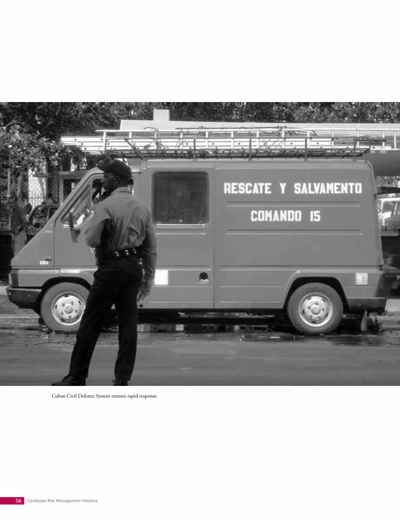
Caribbean Risk Management Initiative56
Cuban Civil Defence System ensures rapid response.
Systematization of Risk Reduction Management Centres 57
Glossary
The following terms have been taken from the United Nations International Strategy for Disaster
Reduction publication 2009 UNISDR Terminology on Disaster Risk Reduction. The UNISDR Terminology
aims to promote a common understanding and usage of disaster risk reduction concepts and to assist
the disaster risk reduction efforts of authorities, practitioners and the public.
Capacity: The combination of all the strengths, attributes and resources available within a commu-
nity, society or organization that can be used to achieve agreed goals.
Capacity Development: The process by which people, organizations and society systematically sti-
mulate and develop their capacities over time to achieve social and economic goals, including through
improvement of knowledge, skills, systems, and institutions.
Coping capacity: The ability of people, organizations and systems, using available skills and resour-
ces, to face and manage adverse conditions, emergencies or disasters.
Disaster: A serious disruption of the functioning of a community or a society involving widespread
human, material, economic or environmental losses and impacts, which exceeds the ability of the affec-
ted community or society to cope using its own resources.
Disaster risk: The potential disaster losses, in lives, health status, livelihoods, assets and services,
which could occur to a particular community or a society over some specified future time period.
Disaster risk management: The systematic process of using administrative directives, organiza-
tions, and operational skills and capacities to implement strategies, policies and improved coping capa-
cities in order to lessen the adverse impacts of hazards and the possibility of disaster.
Disaster risk reduction: The concept and practice of reducing disaster risks through systematic
efforts to analyse and manage the causal factors of disasters, including through reduced exposure to
hazards, lessened vulnerability of people and property, wise management of land and the environ-
ment, and improved preparedness for adverse events.
Disaster risk reduction plan: A document prepared by an authority, sector, organization or enter-
prise that sets out goals and specific objectives for reducing disaster risks together with related actions
to accomplish these objectives.
Early warning system: The set of capacities needed to generate and disseminate timely and me-
aningful warning information to enable individuals, communities and organizations threatened by a ha-
zard to prepare and to act appropriately and in sufficient time to reduce the possibility of harm or loss.

Caribbean Risk Management Initiative58
Hazard: A dangerous phenomenon, substance, human activity or condition that may cause loss of
life, injury or other health impacts, property damage, loss of livelihoods and services, social and eco-
nomic disruption, or environmental damage.
Mitigation: The lessening or limitation of the adverse impacts of hazards and related disasters.
National platform for disaster risk reduction: A generic term for national mechanisms for co-
ordination and policy guidance on disaster risk reduction that are multi-sectoral and inter-disciplinary
in nature, with public, private and civil society participation involving all concerned entities within a
country.
Natural hazard: Natural process or phenomenon that may cause loss of life, injury or other health
impacts, property damage, loss of livelihoods and services, social and economic disruption, or environ-
mental damage.
Preparedness: The knowledge and capacities developed by governments, professional response
and recovery organizations, communities and individuals to effectively anticipate, respond to, and re-
cover from, the impacts of likely, imminent or current hazard events or conditions.
Prevention: The outright avoidance of adverse impacts of hazards and related disasters.
Public awareness: The extent of common knowledge about disaster risks, the factors that lead to
disasters and the actions that can be taken individually and collectively to reduce exposure and vulne-
rability to hazards.
Recovery: The restoration, and improvement where appropriate, of facilities, livelihoods and living
conditions of disaster-affected communities, including efforts to reduce disaster risk factors.
Resilience: The ability of a system, community or society exposed to hazards to resist, absorb,
accommodate to and recover from the effects of a hazard in a timely and efficient manner, including
through the preservation and restoration of its essential basic structures and functions.
Response: The provision of emergency services and public assistance during or immediately after
a disaster in order to save lives, reduce health impacts, ensure public safety and meet the basic subsis-
tence needs of the people affected.
Risk: The combination of the probability of an event and its negative consequences.
Risk assessment: A methodology to determine the nature and extent of risk by analysing potential
hazards and evaluating existing conditions of vulnerability that together could potentially harm expo-
sed people, property, services, livelihoods and the environment on which they depend.
Systematization of Risk Reduction Management Centres 59
Risk management: The systematic approach and practice of managing uncertainty to minimize
potential harm and loss.
Sustainable development: Development that meets the needs of the present without compromi-
sing the ability of future generations to meet their own needs.
Vulnerability: The characteristics and circumstances of a community, system or asset that make it
susceptible to the damaging effects of a hazard.
Caribbean Risk Management Initiative60
Bibliography
Association of Caribbean States (2007). Project Action Plan Rev. 3. High level Conference of the ACS in
Disaster Reduction. Saint- Marc. Haití. November 14-16.
Castro Ruz, Raul (2005). Directiva No.1 del Vicepresidente del Consejo de Defensa Nacional para la
planificación, organización y preparación del país para situaciones de desastre. Havana.
General Staff of Cuban National Civil Defence (2007). Guía para la realización de estudios de riesgo
para situaciones de desastres. Havana.
General Staff of Cuban National Civil Defence (2007). Revista de la Defensa Civil de Cuba. Havana.
General Staff of Cuban National Civil Defence. (2008). Revista de la Defensa Civil de Cuba. Havana.
Inter-institutional Secretariat for the United Nations International Strategy for Risk Reduction. Hyogo
Framework for Action 2005-2015. http://www.unisdr.org/hfa
Inter Press Service (2008).Metas del Milenio - A mitad de camino. 8/01/2008.
Llanes Guerra, Jose (2008). Cuba: Paradigma de la Reducción de Riesgo de desastres. Oxfam Solidari-
dad.
Mesias, Rosendo and Veitia, Zoraida, coordinators (2008). Lecciones y alternativas sobre el problema
habitacional de la Habana Vieja. UNDP Cuba, Havana.
National Institute of Hydraulic Resources. http://www.hidro.cu/culturaagua.htm
System of Measure of Civil Defence (2007). Decreto – Ley No. 170. Official Gazette of the Republic of
Cuba. Number 16, Page 242. Havana.
Thompson, Martha and Izaskun, Gaviria (2004). Cuba, Weathering the Storm: lessons in risk reduction.
Oxfam America.
UN Department of Public Information (2005). Objetivos de Desarrollo del Milenio de la ONU. http://
www.un.org/spanish
UNDP is the UN’s global development network, advocating
for change and connecting countries to knowledge, experi
ence and resources to help people build a better life. We are
on the ground in 166 countries, working with them on their
own solutions to global and national development challen
ges. As they develop local capacity, they draw on the people
of UNDP and our wide range of partners.
The Caribbean Risk Management Initiative (CRMI) is
a know ledge network designed to promote best practices
and build capacity in the region in the fields of risk manage
ment and climate change adaptation. CRMI aims to provide
a platform for sharing the experiences and lessons learned
between different sectors, languages and cultural groups
across the Caribbean in order to facilitate improved disaster
risk reduction
Caribbean Risk Management InitiativeCRMI
Jacinda Fairholm, UNDP CubaTel.: (537) 204-1512Fax: (537) [email protected]
Ian King, UNDP Barbados & OECSTel.: (246) 467-6032Fax: (246) [email protected]
www.undp.org.cu/crmi
June 2010
Joint Staff of National Civil Defence of CubaEMNDC
Department of International Coordination Tel: (537) 864-0110 (537) [email protected]
www.cubagob.cu
Ministry of Foreign Trade and InvestmentMINCEX
www.mincex.cu
Ministerio del
Comercio Exterior y la
Inversión Extranjera
United Nations Development ProgrammeUNDP Cuba