Sydney's Light rail Future · Sydney’s Light Rail Future is focused on expanding light rail...
28
SYDNEY’S LIGHT RAIL FUTURE Expanding public transport, revitalising our city December 2012 Bus FUTURE Bus FUTURE MASTER PLAN MASTER PLAN Transport LIGHT RAIL FUTURE Sydney’s Sydney’s Transport LIGHT RAIL FUTURE
Transcript of Sydney's Light rail Future · Sydney’s Light Rail Future is focused on expanding light rail...

SYDNEY’S LIGHT RAIL FUTUREExpanding public transport, revitalising our city
December 2012
BusFUTURE
BusFUTURE
MASTERPLAN
MASTERPLAN
Transport
LIGHT RAILFUTURE
Sydney’sSydney’s
Transport
LIGHT RAILFUTURE
2
SYDNEY’S LIGHT RAIL FUTUREDECEMBER 2012
BusFUTURE
BusFUTURE
MASTERPLAN
MASTERPLAN
Transport
LIGHT RAILFUTURE
Sydney’sSydney’s
Transport
LIGHT RAILFUTURE
Sydney’s Light Rail FutureExpanding public transport, revitalising our city
ISBN: 978-1-922030-33-7
Copyright notice© State of New South Wales through the Director General of Transport for NSW, 2012.
Transport for NSW 18 Lee Street Chippendale NSW 2008
Disclaimer While every reasonable effort has been made to ensure that this document is correct at the time of printing, the State of NSW, its agents and employees, disclaim any and all liability to any person in respect of anything or the consequences of anything done or omitted to be done in reliance upon the whole or any part of this document.
MINISTER’S MESSAGE 3
THE CHALLENGES 4
THE SOLUTION: INTEGRATING BUSES WITH LIGHT RAIL 7
THE FOUR STAGES OF SYDNEY’S LIGHT RAIL FUTURE 8
PUTTING THE CUSTOMER FIRST 9
INNER WEST LIGHT RAIL EXTENSION 11
CBD AND SOUTH EAST LIGHT RAIL 13
INTEGRATING LIGHT RAIL AND BUSES TO EASE CBD CONGESTION 16
LONG TERM LIGHT RAIL INVESTIGATIONS 20
COMMUNITY INPUT 21
ALTERNATIVE OPTIONS CONSIDERED – HOW THE DECISION WAS MADE 23
CONTENTS
SYDNEY’S LIGHT RAIL FUTUREDECEMBER 2012
3
BusFUTURE
BusFUTURE
MASTERPLAN
MASTERPLAN
Transport
LIGHT RAILFUTURE
Sydney’sSydney’s
Transport
LIGHT RAILFUTURE
MINISTER’S MESSAGE
Light rail can play a significant role in Sydney’s transport future – offering an effective option that builds on our current transport network.
Congestion is costing our economy around $5.1 billion each year – expected to rise to $8.8 billion a year by 2021.
Simply adding more cars and buses to existing routes would only make Sydney’s roads more congested – particularly in the CBD, where the Harbour Bridge, York Street, George Street and Elizabeth Street are often clogged in the peak.
Sydney’s Light Rail Future is the NSW Government’s plan to address these problems.
The NSW Government will deliver a new, fully integrated light rail route from Circular Quay to Kingsford and Randwick, via George Street in the CBD. This project will transform our city – introducing high frequency, reliable services and driving economic development.
We are designing Sydney’s light rail and bus networks together – achieving an integrated solution that will significantly cut CBD congestion. This integration, together with Sydney’s Rail Future and actions we are taking now, will reduce congestion in the centre of our city.
We are already getting on with the job of delivering modern, efficient and reliable light rail solutions. Construction is underway on the 5.6 kilometre Inner West Light Rail extension from Lilyfield to Dulwich Hill – on track for completion in 2014. We have extended MyZone and Pensioner Excursion Tickets to light rail services from Central to Lilyfield, resulting in a jump of 44 per cent of people using light rail last year.
We are also investigating light rail as part of future long term corridor planning, where light rail could offer a viable, sustainable transport solution.
We are committed to working closely with key stakeholders and the broader community to deliver Sydney’s Light Rail Future.
Gladys Berejiklian MP Minister for Transport
4
SYDNEY’S LIGHT RAIL FUTUREDECEMBER 2012
BusFUTURE
BusFUTURE
MASTERPLAN
MASTERPLAN
Transport
LIGHT RAILFUTURE
Sydney’sSydney’s
Transport
LIGHT RAILFUTURE
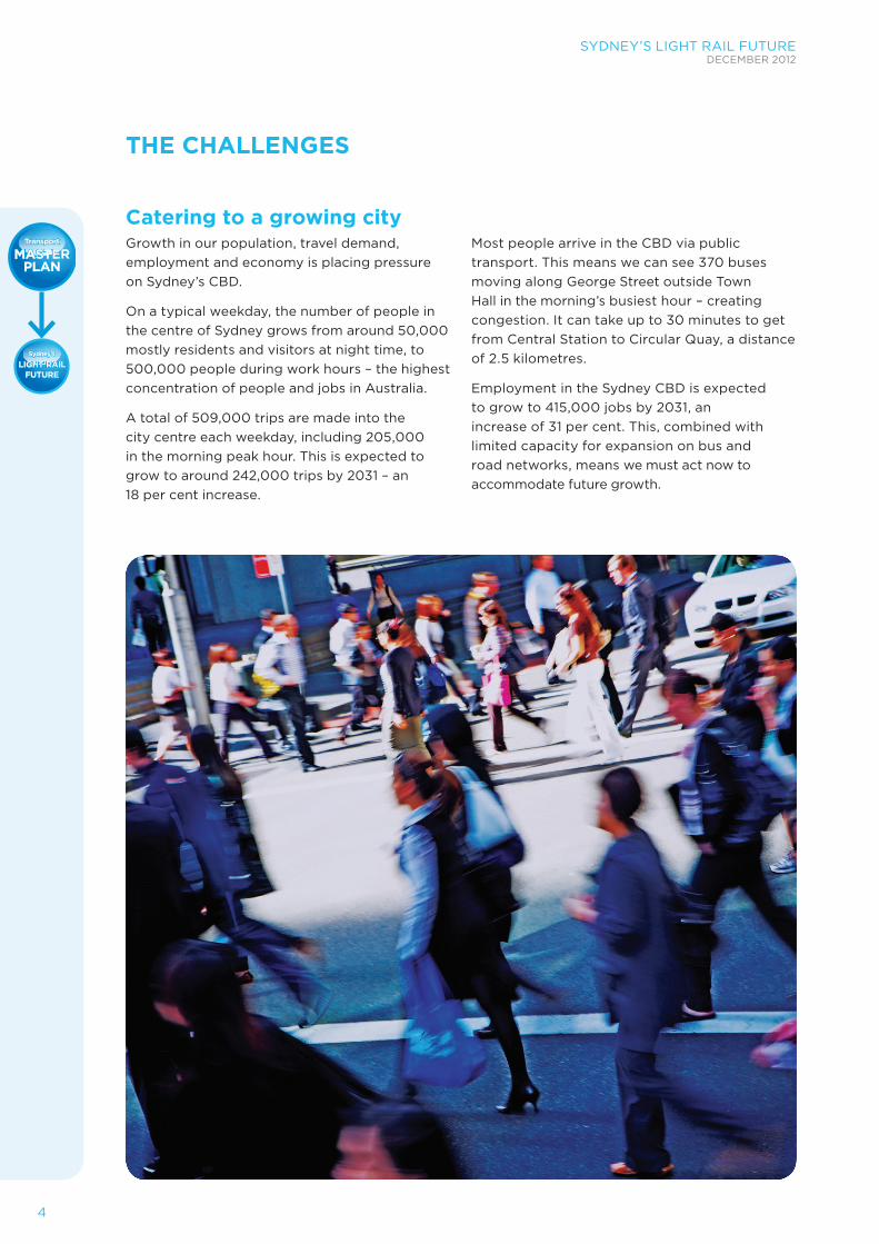
Catering to a growing cityGrowth in our population, travel demand, employment and economy is placing pressure on Sydney’s CBD.
On a typical weekday, the number of people in the centre of Sydney grows from around 50,000 mostly residents and visitors at night time, to 500,000 people during work hours – the highest concentration of people and jobs in Australia.
A total of 509,000 trips are made into the city centre each weekday, including 205,000 in the morning peak hour. This is expected to grow to around 242,000 trips by 2031 – an 18 per cent increase.
Most people arrive in the CBD via public transport. This means we can see 370 buses moving along George Street outside Town Hall in the morning’s busiest hour – creating congestion. It can take up to 30 minutes to get from Central Station to Circular Quay, a distance of 2.5 kilometres.
Employment in the Sydney CBD is expected to grow to 415,000 jobs by 2031, an increase of 31 per cent. This, combined with limited capacity for expansion on bus and road networks, means we must act now to accommodate future growth.
THE CHALLENGES
SYDNEY’S LIGHT RAIL FUTUREDECEMBER 2012
5
BusFUTURE
BusFUTURE
MASTERPLAN
MASTERPLAN
Transport
LIGHT RAILFUTURE
Sydney’sSydney’s
Transport
LIGHT RAILFUTURE
Urban renewalSydney is famed for its quality of life, but increasing congestion, transport capacity constraints and perceptions of inconvenient or inefficient transport services are jeopardising the city’s amenity.
Internationally, light rail has encouraged urban renewal in the form of public spaces, shops, cafes and restaurants – as well as supporting higher density living.
In Sydney, light rail is set to revitalise more areas of the city – contributing to the urban renewal already underway at Barangaroo, Ultimo and Darling Harbour.
Global competitiveness Sydney is a modern, international city where transport is critical to the way we work and live. Economically and culturally, the CBD is at the heart of Sydney and it is where we showcase our city to the world.
To thrive on the global stage, Sydney needs to offer high transport capacity, easy access from all parts of the city and a high quality urban environment to attract international business and tourists. Many cities around the world including Barcelona, Dublin, Zurich, Melbourne, Istanbul, San Francisco, Nottingham, Strasbourg and Manchester feature an integrated light rail network as part of their city.
Transport is integral to promoting Sydney’s global economic competitiveness now and into the future:
• A world class transport network is needed to ensure Sydney remains a number one destination that is competitive internationally
• There needs to be easy access to the Sydney CBD to encourage people and businesses to locate there
• The transport system needs to be able to move commuters quickly and easily around different parts of the CBD to help support economic activity.
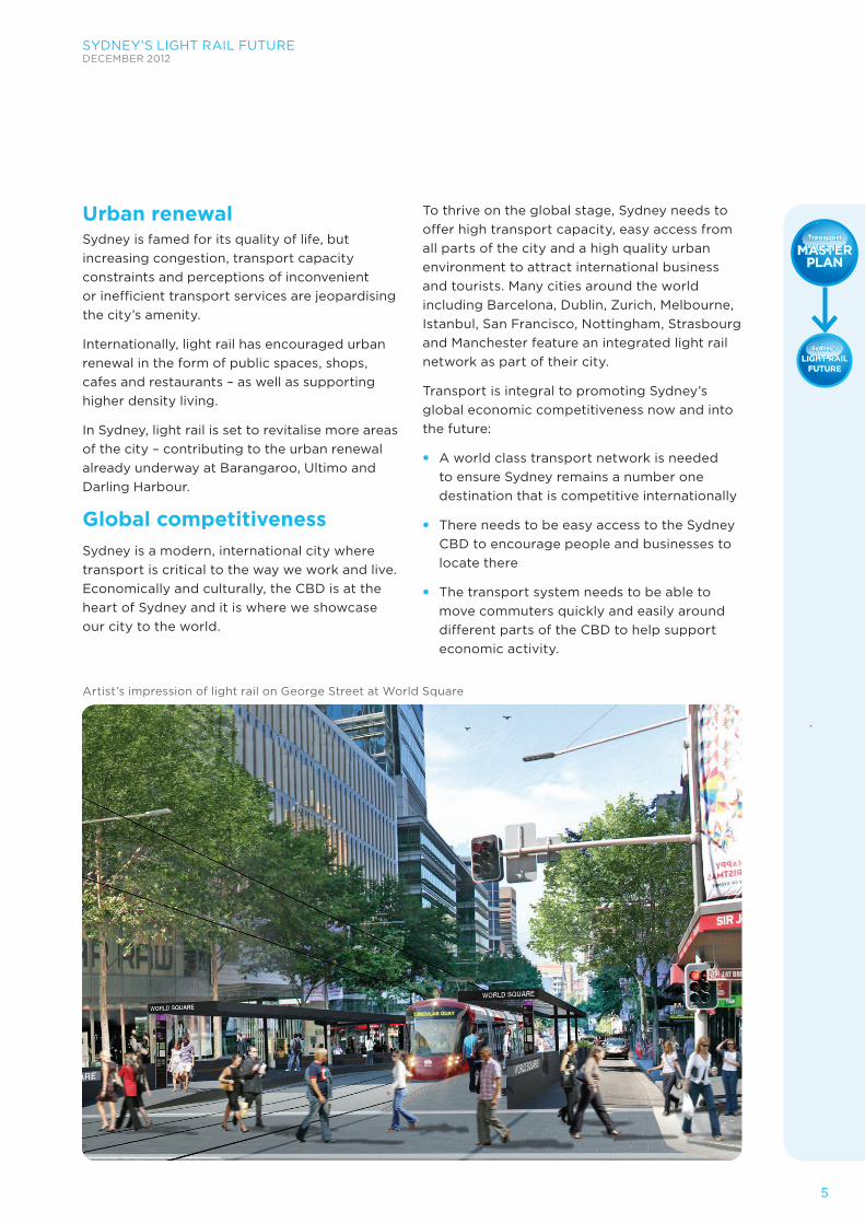
Artist’s impression of light rail on George Street at World Square
6
SYDNEY’S LIGHT RAIL FUTUREDECEMBER 2012
BusFUTURE
BusFUTURE
MASTERPLAN
MASTERPLAN
Transport
LIGHT RAILFUTURE
Sydney’sSydney’s
Transport
LIGHT RAILFUTURE
Unlocking capacity in Sydney’s CBD Sydney’s transport network is structured and shaped by its geography, with main roads established along ridges. This means the CBD is narrow, with long north-south blocks and steep slopes. This, together with established buildings and public spaces, means there is limited capacity to create new routes through the CBD.
Competition for finite road and footpath space in the city is increasing due to additional activity and travel demand.
Currently, 74 per cent of trips into the CBD in morning peak hour are made by public transport – 54 per cent by rail and 20 per cent by bus.
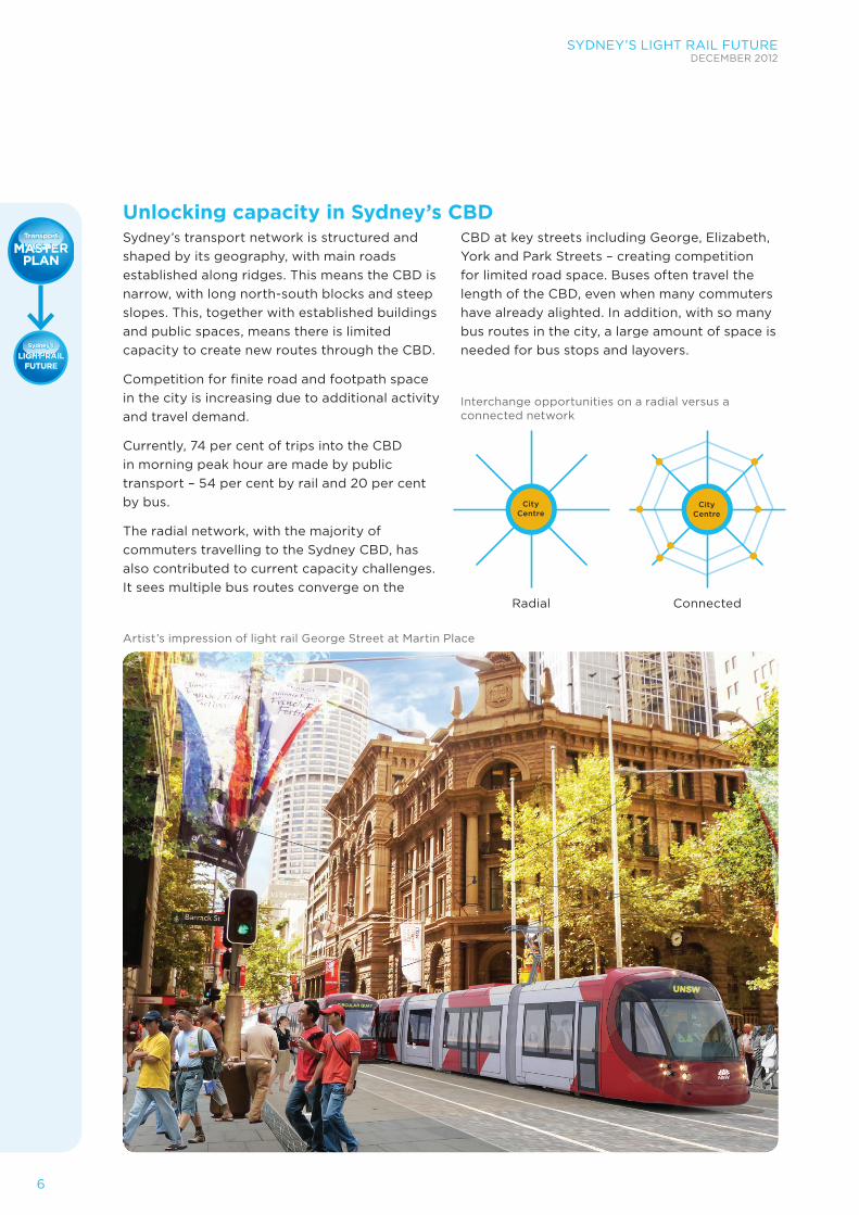
The radial network, with the majority of commuters travelling to the Sydney CBD, has also contributed to current capacity challenges. It sees multiple bus routes converge on the
CBD at key streets including George, Elizabeth, York and Park Streets – creating competition for limited road space. Buses often travel the length of the CBD, even when many commuters have already alighted. In addition, with so many bus routes in the city, a large amount of space is needed for bus stops and layovers.
Artist’s impression of light rail George Street at Martin Place
Interchange opportunities on a radial versus a connected network
Radial Connected
City Centre
City Centre
SYDNEY’S LIGHT RAIL FUTUREDECEMBER 2012
7
BusFUTURE
BusFUTURE
MASTERPLAN
MASTERPLAN
Transport
LIGHT RAILFUTURE
Sydney’sSydney’s
Transport
LIGHT RAILFUTURE
Sydney’s Light Rail Future is focused on expanding light rail services for the CBD and inner Sydney. It represents a step change for transport in the city, significantly boosting capacity and reliability.
The actions outlined in Sydney’s Light Rail Future will also grow public transport capacity, enhance commuter experiences and reduce congestion, leaving more space for vital commercial traffic as well as pedestrians.
We are expanding Sydney’s light rail and streamlining the CBD bus network at the same time to achieve an integrated transport solution for our global city. This integration, together with Sydney’s Rail Future and actions we are taking now, will reduce congestion in the CBD.
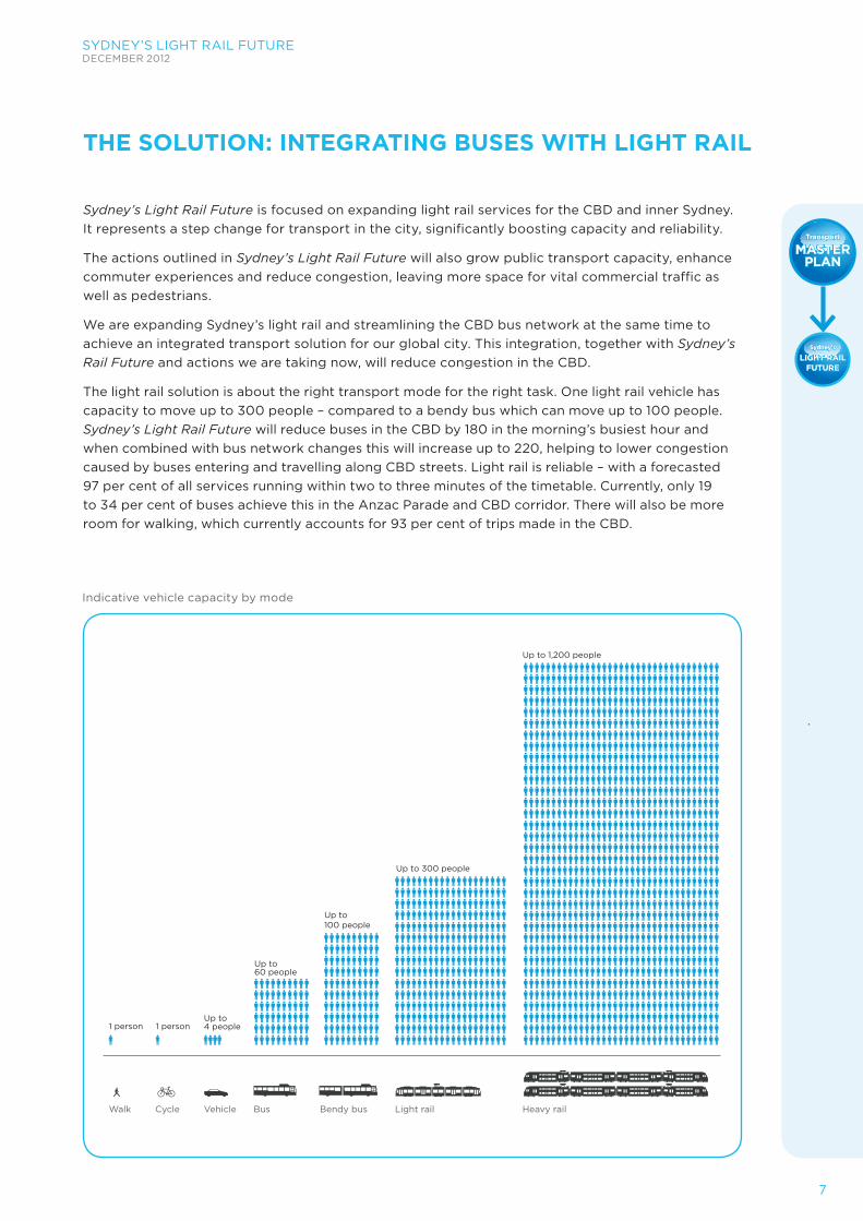
The light rail solution is about the right transport mode for the right task. One light rail vehicle has capacity to move up to 300 people – compared to a bendy bus which can move up to 100 people. Sydney’s Light Rail Future will reduce buses in the CBD by 180 in the morning’s busiest hour and when combined with bus network changes this will increase up to 220, helping to lower congestion caused by buses entering and travelling along CBD streets. Light rail is reliable – with a forecasted 97 per cent of all services running within two to three minutes of the timetable. Currently, only 19 to 34 per cent of buses achieve this in the Anzac Parade and CBD corridor. There will also be more room for walking, which currently accounts for 93 per cent of trips made in the CBD.
THE SOLUTION: INTEGRATING BUSES WITH LIGHT RAIL
Walk
1 person 1 personUp to 4 people
Cycle Vehicle Bus Bendy bus Light rail Heavy rail
Up to 60 people
Up to 100 people
Up to 1,200 people
Up to 300 people
Indicative vehicle capacity by mode
8
SYDNEY’S LIGHT RAIL FUTUREDECEMBER 2012
BusFUTURE
BusFUTURE
MASTERPLAN
MASTERPLAN
Transport
LIGHT RAILFUTURE
Sydney’sSydney’s
Transport
LIGHT RAILFUTURE
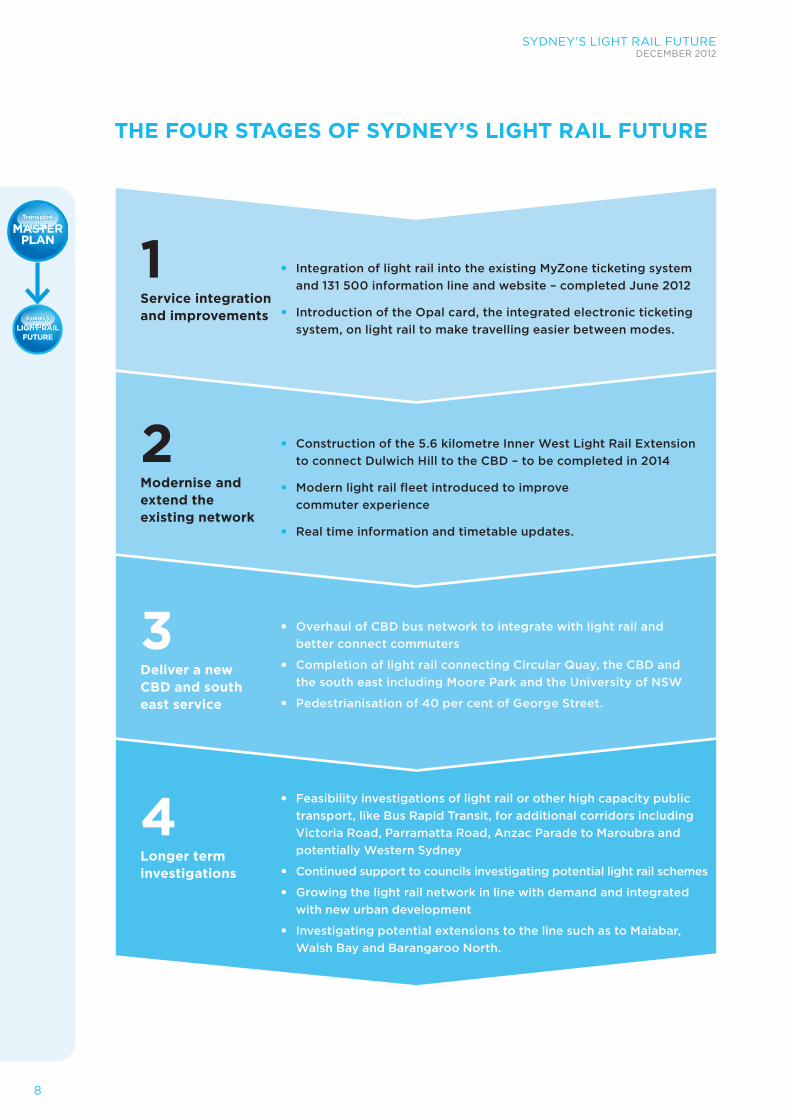
THE FOUR STAGES OF SYDNEY’S LIGHT RAIL FUTURE
• Integration of light rail into the existing MyZone ticketing system and 131 500 information line and website – completed June 2012
• Introduction of the Opal card, the integrated electronic ticketing system, on light rail to make travelling easier between modes.
Service integration and improvements
1
• Construction of the 5.6 kilometre Inner West Light Rail Extension to connect Dulwich Hill to the CBD – to be completed in 2014
• Modern light rail fleet introduced to improve commuter experience
• Real time information and timetable updates.
Modernise and extend the existing network
2
• Overhaul of CBD bus network to integrate with light rail and better connect commuters
• Completion of light rail connecting Circular Quay, the CBD and the south east including Moore Park and the University of NSW
• Pedestrianisation of 40 per cent of George Street.
Deliver a new CBD and south east service
3
Longer term investigations
4 • Feasibility investigations of light rail or other high capacity public transport, like Bus Rapid Transit, for additional corridors including Victoria Road, Parramatta Road, Anzac Parade to Maroubra and potentially Western Sydney
• Continued support to councils investigating potential light rail schemes
• Growing the light rail network in line with demand and integrated with new urban development
• Investigating potential extensions to the line such as to Malabar, Walsh Bay and Barangaroo North.
SYDNEY’S LIGHT RAIL FUTUREDECEMBER 2012
9
BusFUTURE
BusFUTURE
MASTERPLAN
MASTERPLAN
Transport
LIGHT RAILFUTURE
Sydney’sSydney’s
Transport
LIGHT RAILFUTURE
PUTTING THE CUSTOMER FIRST
The NSW Government has put the customer at the centre of Sydney’s Light Rail Future. Light rail in the CBD will benefit a wide range of customers, including:
• Commuters making short trips within the CBD for business, shopping, tourism and recreation
• Commuters travelling from the South East suburbs to the CBD for work, shopping and entertainment
• Students travelling to education at the University of NSW, NIDA and schools along the route
• Patrons travelling to major event precincts at Moore Park and Royal Randwick Racecourse
• Commuters making connections between public transport services at key interchanges in the CBD at Central, Town Hall, Wynyard and Circular Quay
• Staff, patients and visitors travelling to the Randwick health precinct
• Commuters on other bus services from the north, west and south whose trips are delayed by congestion in the CBD.
Turn up and goLight rail services in the CBD will run every two to three minutes in peak times, and slightly less frequently in off-peak. This will offer commuters a ‘turn up and go’ service – meaning spontaneous trips can be taken without needing to consult a timetable. Light rail will run throughout the day and into the night, giving commuters confidence it will be easy to get home late into the evening. Bus and light rail services would have integrated timetables providing easier and convenient interchanges.
A simpler system for allThe existing bus network serving inner Sydney is complex, especially in the CBD. Introducing light rail in the CBD will provide a comfortable, easy to use and reliable service. For people travelling to the Moore Park precinct, it will offer an easy journey to major events.
On George Street, pedestrians will experience a quieter and less chaotic environment with more space to move around. Light rail vehicles can travel through the area at low speeds, allowing pedestrians to comfortably share the space with light rail. And because light rail produces little noise and no local emissions, it can be in Sydney without creating negative impacts to local amenity.
Light rail will be part of Sydney’s integrated ticketing and accessible via the Opal card – offering convenient connections for commuters. We have already started to deliver a range of improvements including the incorporation of light rail into the MyZone ticketing system – which has seen a 44 per cent increase in commuters using light rail in the past year. And we are modernising and extending the existing light rail network in the Inner West to Dulwich Hill. We awarded the light rail vehicle contract in August 2012, which will see new vehicles introduced across the light rail system from 2014.
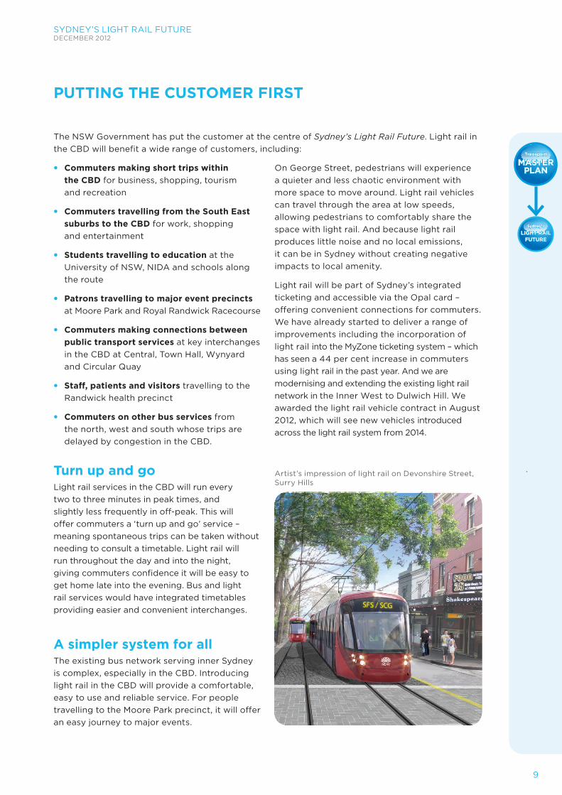
Artist’s impression of light rail on Devonshire Street, Surry Hills
10
SYDNEY’S LIGHT RAIL FUTUREDECEMBER 2012
BusFUTURE
BusFUTURE
MASTERPLAN
MASTERPLAN
Transport
LIGHT RAILFUTURE
Sydney’sSydney’s
Transport
LIGHT RAILFUTURE
OPAL CARD – ONE TICKET FOR ALL TRIPS The electronic ticketing system, accessed using an Opal card, will make commuter journeys seamless.
In 2015, 42 ferry wharves, 307 train stations and more than 5,000 buses and light rail will have Opal card equipment operating in Sydney, the Hunter, Central Coast, the Illawarra, Southern Highlands and the Blue Mountains.
The Opal card will provide an easy, convenient and fast new way of travelling on public transport. Public transport commuters using the Opal card will tap on at the start of their trip and tap off at the end, with the Opal card working much like an e-tag. They will keep the card on a permanent basis and won’t have to queue for tickets or worry about having the right change for their fare. A trial on ferries has begun.
KEY BENEFITS – SYDNEY’S LIGHT RAIL FUTURE
Increased capacity • Space for 300 commuters on each
45 metre long light rail service – equivalent to five standard length buses
• Reduced crowding and congestion
• Buses freed up to service other destinations.
Faster, simpler, more reliable services • ‘Turn up and go’ services every two to
three minutes in peak times
• 97 per cent reliability
• Services that are on time and fast
• Real-time information at all stops and on vehicles, showing route and stop locations
• Simple to navigate
• Effective wayfinding at stops and interchanges, to help you transfer to bus,
ferry or heavy rail.
Urban renewal opportunities • Pedestrian friendly streets, open spaces
and revitalised public areas
• Reduced congestion at the heart of the CBD
• A more attractive, accessible environment for visitors, businesses and workers
• Improved connections where people live, work and visit.
Improved amenity • Integrated, electronic ticketing available at
outlets or on-board
• Light rail stops maximise accessibility, with multiple doors available to alight at your stop
• Smooth, comfortable and quiet services, with air-conditioned vehicles
• Safe, clean, accessible and comfortable environment.
SYDNEY’S LIGHT RAIL FUTUREDECEMBER 2012
11
BusFUTURE
BusFUTURE
MASTERPLAN
MASTERPLAN
Transport
LIGHT RAILFUTURE
Sydney’sSydney’s
Transport
LIGHT RAILFUTURE
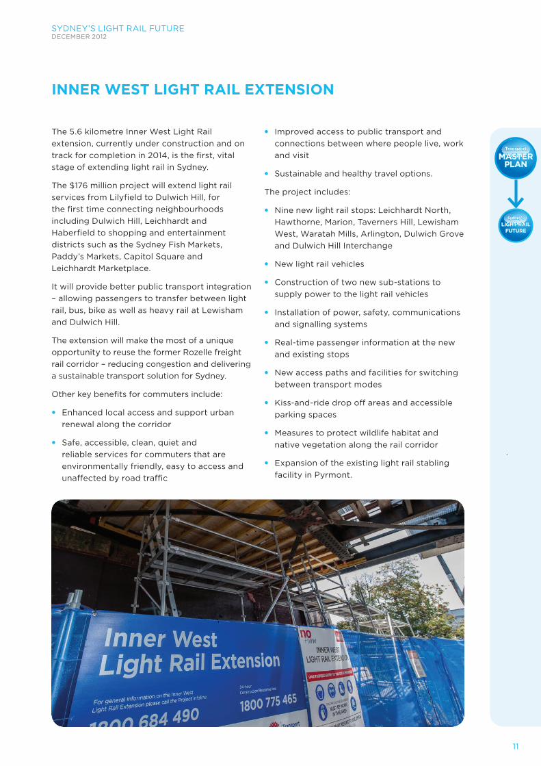
The 5.6 kilometre Inner West Light Rail extension, currently under construction and on track for completion in 2014, is the first, vital stage of extending light rail in Sydney.
The $176 million project will extend light rail services from Lilyfield to Dulwich Hill, for the first time connecting neighbourhoods including Dulwich Hill, Leichhardt and Haberfield to shopping and entertainment districts such as the Sydney Fish Markets, Paddy’s Markets, Capitol Square and Leichhardt Marketplace.
It will provide better public transport integration – allowing passengers to transfer between light rail, bus, bike as well as heavy rail at Lewisham and Dulwich Hill.
The extension will make the most of a unique opportunity to reuse the former Rozelle freight rail corridor – reducing congestion and delivering a sustainable transport solution for Sydney.
Other key benefits for commuters include:
• Enhanced local access and support urban renewal along the corridor
• Safe, accessible, clean, quiet and reliable services for commuters that are environmentally friendly, easy to access and unaffected by road traffic
• Improved access to public transport and connections between where people live, work and visit
• Sustainable and healthy travel options.
The project includes:
• Nine new light rail stops: Leichhardt North, Hawthorne, Marion, Taverners Hill, Lewisham West, Waratah Mills, Arlington, Dulwich Grove and Dulwich Hill Interchange
• New light rail vehicles
• Construction of two new sub-stations to supply power to the light rail vehicles
• Installation of power, safety, communications and signalling systems
• Real-time passenger information at the new and existing stops
• New access paths and facilities for switching between transport modes
• Kiss-and-ride drop off areas and accessible parking spaces
• Measures to protect wildlife habitat and native vegetation along the rail corridor
• Expansion of the existing light rail stabling facility in Pyrmont.
INNER WEST LIGHT RAIL EXTENSION
12
SYDNEY’S LIGHT RAIL FUTUREDECEMBER 2012
BusFUTURE
BusFUTURE
MASTERPLAN
MASTERPLAN
Transport
LIGHT RAILFUTURE
Sydney’sSydney’s
Transport
LIGHT RAILFUTURE
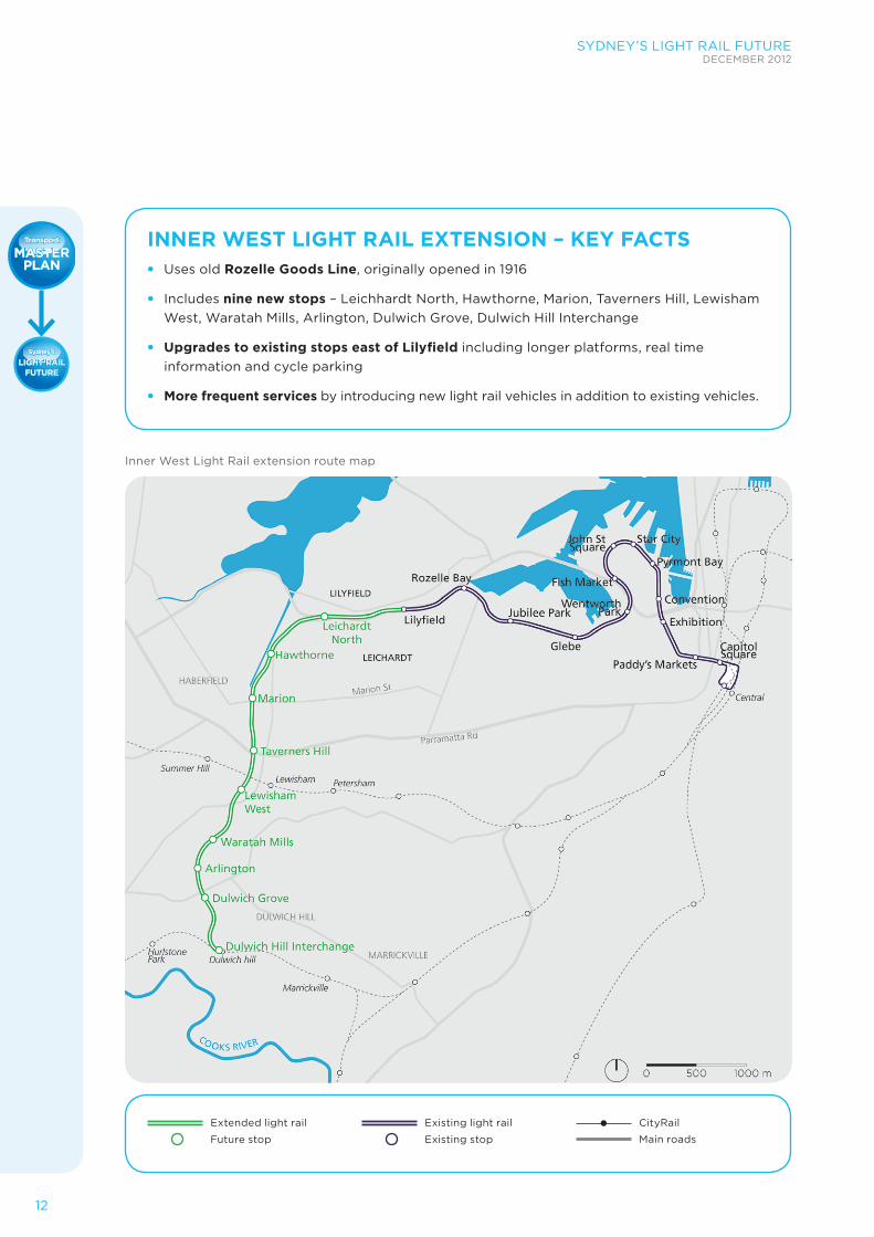
INNER WEST LIGHT RAIL EXTENSION – KEY FACTS • Uses old Rozelle Goods Line, originally opened in 1916
• Includes nine new stops – Leichhardt North, Hawthorne, Marion, Taverners Hill, Lewisham West, Waratah Mills, Arlington, Dulwich Grove, Dulwich Hill Interchange
• Upgrades to existing stops east of Lilyfield including longer platforms, real time information and cycle parking
• More frequent services by introducing new light rail vehicles in addition to existing vehicles.
Extended light rail
Future stop
Existing light rail
Existing stop
CityRail
Main roads
Inner West Light Rail extension route map
SYDNEY’S LIGHT RAIL FUTUREDECEMBER 2012
13
BusFUTURE
BusFUTURE
MASTERPLAN
MASTERPLAN
Transport
LIGHT RAILFUTURE
Sydney’sSydney’s
Transport
LIGHT RAILFUTURE
The projectFollowing extensive feasibility investigations and consultation, the NSW Government is proceeding with a new light rail line extending from Circular Quay through George Street to Central Station and to the University of NSW via Anzac Parade and Alison Road.
Light rail in the CBD will be the step-change needed to transform Sydney. It will unlock the streets, open the CBD’s capacity and be the catalyst for creating a liveable and globally competitive city.
The benefitsThe new CBD and South East Light Rail will offer a simple, user-friendly way to travel between key attractions – from the Rocks and Circular Quay to the city’s retail heart and on to Chinatown, linking visitors staying in our world-class hotels to the in-progress Sydney International Convention and Exhibition Centre.
New, high frequency light rail will benefit commuters travelling from the South East suburbs to the CBD for work, shopping and entertainment, students travelling to the University of NSW and Sydney Boys and
CBD AND SOUTH EAST LIGHT RAIL
CBD and South East Light Rail – Key facts Opal card – the electronic ticketing system – will be implemented on all light rail services.
Circular Quay to Central Station
• Three kilometre route along a dedicated corridor with a 15 minute journey time
• Service reliability of 97 per cent
• Nine stops in the CBD between Circular Quay and Central
• Interchange with heavy rail, bus and ferry services at Circular Quay, Wynyard, Town Hall and Central Stations
• ‘Turn up and go’ services, with services every two to three minutes during peak periods and continued high frequency across the day, evenings and weekends
• Pedestrianised zone on George Street between Hunter and Bathurst Streets.
Central Station to Nine Ways at Kingsford
• Six kilometre route along a dedicated corridor with a 24 minute journey time
• Seven stops between Central and Kingsford, including the University of NSW at Anzac Parade and Moore Park
• Bus interchange at Kingsford
• ‘Turn up and go’ services across the day, evenings, weekends and nights.
Central Station to Randwick
• Six kilometre route along a dedicated corridor with a 20 minute journey time
• Seven stops between Central and Randwick, serving the Prince of Wales Hospital, University of NSW at Wansey Road, Randwick Racecourse and Moore Park
• Potential to join two vehicles together for special events at Moore Park – doubling capacity to move up to 18,000 commuters each hour in each direction
• Bus interchange at Randwick
• ‘Turn up and go’ services across the day, evenings, weekends and nights.
Light Rail Vehicles
• Air-conditioned, accessible low-floor design, electric powered
• Capacity for approximately 100 seated and 200 standing passengers
• Can carry up to 9,000 passengers per hour in each direction on a highly reliable service that is not impacted by traffic congestion.
14
SYDNEY’S LIGHT RAIL FUTUREDECEMBER 2012
BusFUTURE
BusFUTURE
MASTERPLAN
MASTERPLAN
Transport
LIGHT RAILFUTURE
Sydney’sSydney’s
Transport
LIGHT RAILFUTURE
Sydney Girls high schools at Moore Park and customers and staff, patients and visitors travelling to the Randwick health precinct.
Light rail will also make it more convenient for commuters to change between modes in the CBD, take short trips within the city for business or recreation and travel to major event precincts at Moore Park and Royal Randwick Racecourse.
Light rail in the CBD and to the South East will enable urban renewal, particularly along Anzac Parade. Light rail in the CBD will also be accompanied by public domain improvements including revitalised public spaces.
Further benefits include:
• 15 minute, reliable journeys through from the Circular Quay to Central Station along George Street
• Capacity to move up to 9,000 people per hour in each direction
• 180 fewer buses in the CBD in the morning peak hour between 8:00am-9:00am
• Improved safety for pedestrians who make one million journeys in the CBD each day.
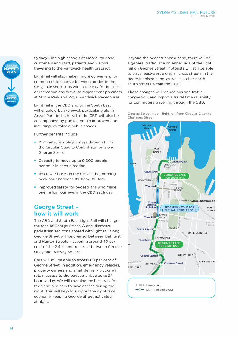
George Street – how it will work The CBD and South East Light Rail will change the face of George Street. A one kilometre pedestrianised zone shared with light rail along George Street will be created between Bathurst and Hunter Streets – covering around 40 per cent of the 2.4 kilometre street between Circular Quay and Railway Square.
Cars will still be able to access 60 per cent of George Street. In addition, emergency vehicles, property owners and small delivery trucks will retain access to the pedestrianised zone 24 hours a day. We will examine the best way for taxis and hire cars to have access during the night. This will help to support the night time economy, keeping George Street activated at night.
Beyond the pedestrianised zone, there will be a general traffic lane on either side of the light rail on George Street. Motorists will still be able to travel east-west along all cross streets in the pedestrianised zone, as well as other north-south streets within the CBD.
These changes will reduce bus and traffic congestion, and improve travel time reliability for commuters travelling through the CBD.
George Street map – light rail from Circular Quay to Chalmers Street
1201
3v_0
7_sl
ide
34_r
oute
impa
cts.
ai
DEDICATED LANEFOR LIGHT RAIL
PEDESTRIAN ZONE FORLIGHT RAIL VEHICLES ONLY
DEDICATED LANEFOR LIGHT RAIL
William St
Hunter St
Bathurst St
Western
Distributor
Oxford StEastern D
istributor
Parramatta Rd
Wattle St
Geo
rge
St
Pit
t S
t
Eliz
abet
h S
t
Co
lleg
e S
t
Oxford St
CIRCULARQUAY
MARTINPLACE
ST JAMES
KINGSCROSS
TOWNHALL
WYNYARD
MUSEUM
CENTRAL Chalmers Street
Central Station
Chinatown
World Square
Town Hall
Wynyard
CBD North
Circular Quay
QueenVictoriaBuilding
CHIPPENDALE
HAYMARKET
WOOLLOOMOOLOO
DAWESPOINT
WALSHBAY
BARANGAROO
THEROCKS
POTTSPOINT
DARLINGHURST
PADDINGTON
SURRY HILLS
ULTIMO
Heavy rail
Light rail and stops
SYDNEY’S LIGHT RAIL FUTUREDECEMBER 2012
15
BusFUTURE
BusFUTURE
MASTERPLAN
MASTERPLAN
Transport
LIGHT RAILFUTURE
Sydney’sSydney’s
Transport
LIGHT RAILFUTURE
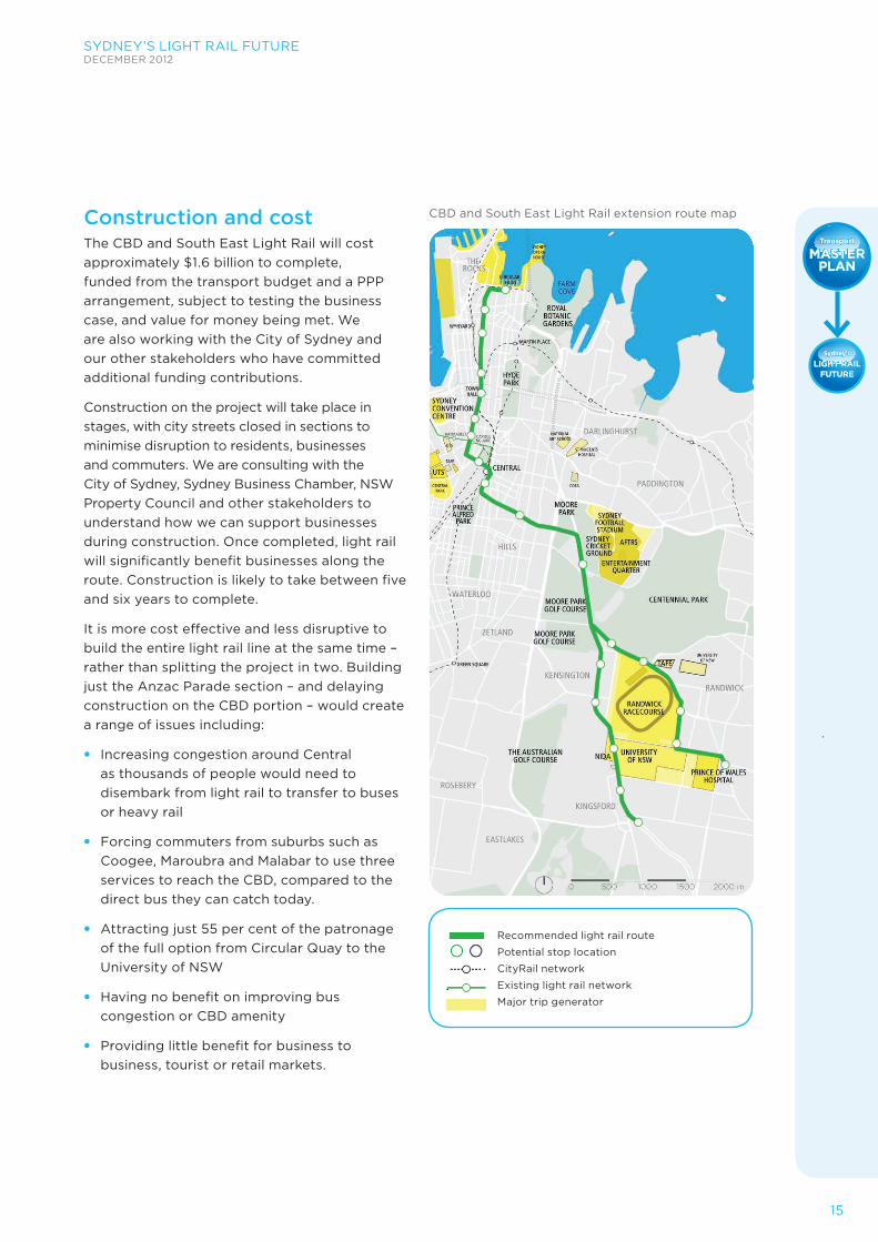
Construction and costThe CBD and South East Light Rail will cost approximately $1.6 billion to complete, funded from the transport budget and a PPP arrangement, subject to testing the business case, and value for money being met. We are also working with the City of Sydney and our other stakeholders who have committed additional funding contributions.
Construction on the project will take place in stages, with city streets closed in sections to minimise disruption to residents, businesses and commuters. We are consulting with the City of Sydney, Sydney Business Chamber, NSW Property Council and other stakeholders to understand how we can support businesses during construction. Once completed, light rail will significantly benefit businesses along the route. Construction is likely to take between five and six years to complete.
It is more cost effective and less disruptive to build the entire light rail line at the same time – rather than splitting the project in two. Building just the Anzac Parade section – and delaying construction on the CBD portion – would create a range of issues including:
• Increasing congestion around Central as thousands of people would need to disembark from light rail to transfer to buses or heavy rail
• Forcing commuters from suburbs such as Coogee, Maroubra and Malabar to use three services to reach the CBD, compared to the direct bus they can catch today.
• Attracting just 55 per cent of the patronage of the full option from Circular Quay to the University of NSW
• Having no benefit on improving bus congestion or CBD amenity
• Providing little benefit for business to business, tourist or retail markets.
Recommended light rail route
Potential stop location
CityRail network
Existing light rail network
Major trip generator
CBD and South East Light Rail extension route map
16
SYDNEY’S LIGHT RAIL FUTUREDECEMBER 2012
BusFUTURE
BusFUTURE
MASTERPLAN
MASTERPLAN
Transport
LIGHT RAILFUTURE
Sydney’sSydney’s
Transport
LIGHT RAILFUTURE
In today’s morning peak one hour, between 8:00am and 9:00am, buses bring 41,000 people into the city, while 19,500 other vehicles bring in a further 24,000 people. Over the next 20 years, trips into the Sydney CBD are set to grow by 31 per cent – an additional 56,500 trips, the equivalent of 942 standard buses.
Putting more vehicles onto our roads to manage these trips will worsen congestion. We need an integrated public transport solution, featuring light rail along George Street, to ease congestion in our CBD.
Introducing light rail Light rail in the CBD is part of the series of changes we are progressively rolling-out to ease congestion. Light rail is reliable – with 97 per cent of all services running within two to three minutes of the timetable. Currently, only 19 to 34 per cent of buses achieve this in the Anzac Parade and CBD corridor.
Light rail would run along George Street from Circular Quay to Central Station in 15 minutes. Thirty light rail vehicles per hour would run up and down the CBD carrying up to 9,000 passengers every hour – a task that would require the equivalent of 150 standard buses or 90 bendy buses.
Light rail would take 180 buses out of the CBD while additional bus network changes would bring this to a total of about 220 fewer buses entering the city centre in the morning peak hour. Many buses will also terminate earlier, allowing passengers to interchange to light rail. This would create a more attractive, accessible and safer environment for pedestrians, who make up about 90 per cent – or one million – of the trips within the CBD each day.
Redesigning the bus network We are completely redesigning the bus network to create simpler, faster and better bus services for commuters, delivering:
• More services on fewer routes to ensure buses are full when they enter the CBD
• More cross-city Metro-style bus routes, avoiding the city centre
• More buses on fewer streets with higher bus priority levels
• Seamless transfers between high-frequency, reliable buses, light rail and rail for commuters.
Key features of redesigning the bus network in the City Centre • Elizabeth Street will be
the main north-south bus route, featuring dedicated bus lanes and stopping lanes and with car access available in both directions
• Park Street and Druitt Street will be the main east-west bus routes, providing access for buses only between Clarence Street and Kent Street
• Northern bus services will enter the CBD along York Street or Clarence Street or via the Cahill Expressway
• A western CBD bus corridor will connect Barangaroo to the bus network
• Commuters can transfer between north-south and east-west routes at an interchange on Park Street.
INTEGRATING LIGHT RAIL AND BUSES TO EASE CBD CONGESTION
SYDNEY’S LIGHT RAIL FUTUREDECEMBER 2012
17
BusFUTURE
BusFUTURE
MASTERPLAN
MASTERPLAN
Transport
LIGHT RAILFUTURE
Sydney’sSydney’s
Transport
LIGHT RAILFUTURE
Bridge Street
Hunter Street
Market Street
Druitt Street
Bathurst Street
Liverpool Street
Campbell Street
Hay Street
Albion Street
Eddy Avenue
Park Street
Eliz
abet
h St
reet
Eliz
abet
h St
reet
Geo
rge
Stre
etCar
ringt
on S
tree
t
Geo
rge
Stre
et
Cla
renc
e St
reet
York
Str
eet
Cas
tlere
agh
Stre
et
Phill
ip S
tree
t
WilliamStreet
Argyle Street
Oxford Street
Pitt
Str
eet
BelmorePark
Hyde
Park
Pitt
Str
eet
Mal
lPi
tt S
tree
t
King Street
Goulburn Street
TheRocks
®
Circular Quay
QVB
TownHall
Central
StJames
Museum
MartinPlace
BotanyCoogee
Wynyard
N
Railway Square
Circular Quay
311327 389324
326325
461 480 483
441
M10380
311
392
333378
394377
396397L94
399
L88393L90
395311
378372 310
395343
372 393
308309M20
M10426412
428413
423431422
436 438433439 461 470440480 483
301324
302325
303326
309
376 377374 380333
310
389392 394 L94 396 397399
422 423 426
443428
504 506500
507470
515518
M52
301 302 303
339391374
376
169 180243178
246 247245244
179
273
WynyardCarrington Street
203207
King St Wharf412 413
Millers Point339 431 433
311391343
327
Circular Quay
443
441
507500
515504
506
M52
518
501
QVB252
288254
290261
292442
M20 M30L88 L90 243
244 245
169203178 179
207180
247246 252 254288 290 292
M30
439440
438436
M40
M40
442M50
Legend:Bus Stop
301
TerminusCityRail Station
Ferry WharfRoute Number
Art Gallery
The Domain
Maroubra JnBondi Jn
ChatswoodGore Hill
Spit Jn
Spit Jn
ChatswoodGore Hill
Route 433 operatesfrom Walsh Bay
(Hickson Rd - Pier 4)nightly between
6:30pm and Midnight
Route 339, 431 & 433operate via Argyle St &Essex St on Saturdayand Sunday duringThe Rocks Markets
Gresham Street
TownHall501
M50
CityRail Stationwith directAirport Line Service
373
373
L85261
263 273
263
L85
202
202
Existing pm bus network Proposed bus network
George Street light rail
North-south bus spine, including new bus priority lanes
East-west bus spine
York-Clarence corridor
Western CBD/Barangaroo corridor
Source: Transport for NSW
Comparing bus and light rail reliability
97%
Arrives within two minutes
of the scheduled time
Light RailBuses
19-34%
18
SYDNEY’S LIGHT RAIL FUTUREDECEMBER 2012
BusFUTURE
BusFUTURE
MASTERPLAN
MASTERPLAN
Transport
LIGHT RAILFUTURE
Sydney’sSydney’s
Transport
LIGHT RAILFUTURE
Contributing to CBD congestion cuts – Sydney’s Rail FutureCongestion cuts will continue with the North West Rail Link, which will remove a further 160 buses from the Harbour Bridge and deliver high capacity, single deck trains every five minutes from the North West into the CBD. In the longer term, the second Harbour rail crossing and new CBD line will see the network carry up to 100,000 more people an hour – offering significant incentive for commuters to leave the car at home and take public transport.
Diverting buses onto the Cahill ExpresswayStarting in early 2013, we will re-direct more than seven per cent of current morning peak bus services from the North West – about 60 buses – from the Harbour Bridge onto the Cahill Expressway. This will reduce the queue of buses waiting to enter York Street from the Harbour Bridge, ease congestion at the busy Wynyard interchange and help make bus services more reliable for commuters. These buses would terminate at Bridge Street.
To:Through:
Total:
11340
17584
423
5299
2245
456
37915
4
4933
85 49
N
EXISTING NETWORK Inbound buses
Outbound buses
0 250 500 750 1000
1010IN
458OUT
To:Through:
Total:
-28
-33
+1
-27
-7
+4
-55
-33
-49
+8
-2
-3
+14
+63
0
+3
-49
-24
N
Change in inbound buses
Change in outbound buses
-227IN
+9OUT
0 250 500 750 1000
Existing bus network am peak hour (8:00 to 9:00am) bus volumes
Light rail and redesigned bus network am peak hour (8:00 to 9:00am) change in bus volumes
Inbound buses Outbound buses
SYDNEY’S LIGHT RAIL FUTUREDECEMBER 2012
19
BusFUTURE
BusFUTURE
MASTERPLAN
MASTERPLAN
Transport
LIGHT RAILFUTURE
Sydney’sSydney’s
Transport
LIGHT RAILFUTURE
FIVE STEPS TO CUT CBD CONGESTION 1. Diverting 60 buses in 2013 onto the Cahill Expressway and other operational improvements,
including the double-decker bus trial, a dedicated police motorcycle team to keep traffic moving and changes to traffic signalling and parking
2. Redesigning the bus network to make services simpler, faster and better for commuters, which together with light rail, would remove about 220 buses from entering the CBD in the busiest hour
3. Light rail in the CBD and South East to move 9,000 people every hour, achieve 97 per cent reliability and revitalise and activate city streets
4. North West Rail Link to deliver faster travel times to the CBD for more than 300,000 commuters with faster, single deck trains every five minutes in peak periods. Commuters moving onto the NWRL will mean a further reduction of 160 buses entering the CBD
5. Second Harbour rail crossing and new CBD line with capacity to carry up to 100,000 more people an hour – a significant incentive to take public transport.
20
SYDNEY’S LIGHT RAIL FUTUREDECEMBER 2012
BusFUTURE
BusFUTURE
MASTERPLAN
MASTERPLAN
Transport
LIGHT RAILFUTURE
Sydney’sSydney’s
Transport
LIGHT RAILFUTURE
Long term light rail planning Light rail has the potential to play a more prominent role in Greater Sydney’s future transport network. We will undertake ongoing investigations to determine the best way to provide fast, reliable and flexible transport on key corridors throughout Sydney. Light rail will integrate with the heavy rail, bus and ferry network.
Extending and enhancing Sydney’s public transport networkThe demand for transport in Sydney is continuing to grow and commuters’ travel patterns are changing. Light rail offers an opportunity to provide a high quality transport service that can be extended over time to connect key centres and strengthen communities.
The NSW Long Term Transport Master Plan has nominated a number of strategic transit network corridors to be considered for bus rapid transit or light rail.
LONG TERM LIGHT RAIL INVESTIGATIONS
The priority corridors for further investigation are:
• Parramatta Road
• Victoria Road
• Anzac Parade between Kingsford and Maroubra or Malabar
• Western Sydney light rail network.
We will investigate and take action on these corridors as demand for public transport increases. In the short term, improvements in service frequency and bus priority will help us to build a strong customer base for any potential future light rail extension. These are detailed in the NSW Long Term Transport Master Plan.
Investigations with Parramatta City Council The NSW Government is working with Parramatta City Council to complete a Western Sydney Light Rail Feasibility Study. The study is looking at a transport network to serve Parramatta’s growth and it will determine the best mode and alignment to encourage transport demand and urban renewal.
Artist’s impression of light rail on Parramatta Road, Camperdown
SYDNEY’S LIGHT RAIL FUTUREDECEMBER 2012
21
BusFUTURE
BusFUTURE
MASTERPLAN
MASTERPLAN
Transport
LIGHT RAILFUTURE
Sydney’sSydney’s
Transport
LIGHT RAILFUTURE
The development of Sydney’s Light Rail Future has drawn on extensive research and stakeholder consultation, which has been carefully considered.
Sydney Light Rail Round TableThe Sydney Light Rail Round Table and its working groups have engaged in discussion and information exchange on topics related to the development of Sydney’s Light Rail Future.
The NSW Minister for Transport, Gladys Berejiklian MP, convened the first Round Table in September 2011 to enable stakeholders to have input to the development of Sydney’s Light Rail Future.
The Minister invited representatives and organisations located in, or associated with, the Study Area to be members of the Round Table. They included councils, health and education providers, events and recreation precincts, as well as government organisations and select representative organisations.
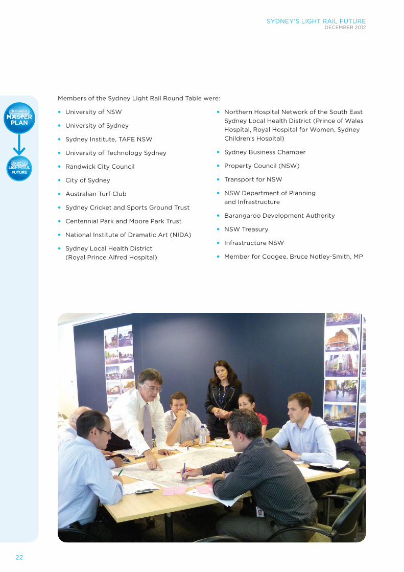
The Round Table was the primary forum for engaging with key stakeholders, bringing together executive level members of relevant agencies and institutions to provide regular updates on the progress of the project, and to receive local expertise and feedback at key project milestones. The Round Table was supported by a series of Technical Working Group meetings. In total, we held five Round Table meetings and four Technical Working Group sessions.
The Sydney Light Rail Round Table influenced a number of elements of the project, including:
1. Project objectives: Feedback was received on the draft policy aims and project objectives at multiple meetings which subsequently informed the development of the final project objectives and criteria against which route options were assessed.
2. Customer needs: Organisations provided detailed information outlining current and anticipated travel needs which helped to inform Sydney’s Light Rail Future.
3. The Study Area: Stakeholders offered advice about their plans for future development, which were taken into account. Discussions regarding the broader Study Area included suggestions to include the corridor between the Sydney CBD and Green Square and to Bondi.
4. The long list of route options: Stakeholders provided feedback and input to the long list of route options considered. Randwick City Council provided its Light Rail Pre-feasibility Study which informed the route options considered.
5. Refinement of route options: Some route options were amended or added based on stakeholder discussions. An additional route segment option was added in the southern University of NSW corridor, which included Wansey Road as an alternative to Belmore Road in Randwick.
COMMUNITY INPUT
22
SYDNEY’S LIGHT RAIL FUTUREDECEMBER 2012
BusFUTURE
BusFUTURE
MASTERPLAN
MASTERPLAN
Transport
LIGHT RAILFUTURE
Sydney’sSydney’s
Transport
LIGHT RAILFUTURE
Members of the Sydney Light Rail Round Table were:
• University of NSW
• University of Sydney
• Sydney Institute, TAFE NSW
• University of Technology Sydney
• Randwick City Council
• City of Sydney
• Australian Turf Club
• Sydney Cricket and Sports Ground Trust
• Centennial Park and Moore Park Trust
• National Institute of Dramatic Art (NIDA)
• Sydney Local Health District (Royal Prince Alfred Hospital)
• Northern Hospital Network of the South East Sydney Local Health District (Prince of Wales Hospital, Royal Hospital for Women, Sydney Children’s Hospital)
• Sydney Business Chamber
• Property Council (NSW)
• Transport for NSW
• NSW Department of Planning and Infrastructure
• Barangaroo Development Authority
• NSW Treasury
• Infrastructure NSW
• Member for Coogee, Bruce Notley-Smith, MP
SYDNEY’S LIGHT RAIL FUTUREDECEMBER 2012
23
BusFUTURE
BusFUTURE
MASTERPLAN
MASTERPLAN
Transport
LIGHT RAILFUTURE
Sydney’sSydney’s
Transport
LIGHT RAILFUTURE
ALTERNATIVE OPTIONS CONSIDERED – HOW THE DECISION WAS MADE
Our study investigated the feasibility of light rail in three high priority corridors – the CBD, the University of Sydney and the University of NSW.
A shortlist of 11 route options were selected and investigated in consultation with councils, universities, business groups, TAFE, hospitals, major sporting and entertainment precincts and other key groups.
Next, our team of specialists developed and analysed the 11 route options, taking into account substantial work previously carried out. For each option, the following factors were considered:
• Ability to meet key objectives
• Costs and benefits
• Anticipated demand.
For the CBD to UNSW we also considered whether light rail or buses would be best suited to the corridor.
CBD options The CBD corridor experiences high transport demand and has limited capacity to accommodate additional buses to meet future growth.
Investigations determined routes alternative to George Street, such as Pitt Street, Castlereagh Street and Sussex Street, were not feasible to accommodate light rail as a result of their narrow widths and multiple vehicle access points. Other issues included steep slopes at the northern end of Castlereagh Street and Sussex Street, the need to maintain access to the Western Distributor and high pedestrian numbers in Pitt Street Mall.
We also considered a light rail link to Barangaroo via the Rocks and Walsh Bay. However, even with significant future development at Barangaroo, passenger numbers were forecast to be very low. This was because Wynyard Walk would provide a more direct link to other bus and rail services than any light rail service along this route. The area will also be serviced by a new ferry hub at Barangaroo. However, Hickson Road does allow for a potential bus or light rail service in the future.
University of NSW options The University of NSW corridor serves several major key activity hubs, including:
• Sporting precincts at Sydney Football Stadium, Sydney Cricket Ground, Randwick Racecourse
• Recreation and entertainment facilities including Fox Studios and the Hordern Pavilion at Centennial Parklands
• Randwick Education and Health Specialised Centre including the University of NSW and Randwick Precinct Hospitals
• High density centres in Surry Hills, Randwick and Kensington.
Major events at Moore Park and Randwick Racecourse, together with the University of NSW campus, generate significant travel demand during peak and off-peak times. This corridor currently relies on buses for public transport. The following alternative route options were considered in this corridor:
• Via Green Square
• Via Darlinghurst
• Via Randwick.
24
SYDNEY’S LIGHT RAIL FUTUREDECEMBER 2012
BusFUTURE
BusFUTURE
MASTERPLAN
MASTERPLAN
Transport
LIGHT RAILFUTURE
Sydney’sSydney’s
Transport
LIGHT RAILFUTURE
Via Green Square City of Sydney investigations indicated light rail could play a role in connecting Green Square with the Sydney CBD. Light rail options to serve Green Square via the University of NSW were initially considered as part of the long list of route options. However, a light rail extension to Green Square could not efficiently service the University of NSW– as travel time would be slower than taking an existing bus service. On this basis, a light rail link to Green Square was not further assessed. It has not been ruled out as a potential longer term option.
Via Darlinghurst We investigated a number of routes to Taylor Square via either Oxford Street or Campbell Street – connecting UNSW to Town Hall Station. While Oxford Street’s high density and mix of land uses could potentially support light rail, investigations showed a direct link from Central Station via Surry Hills was required to efficiently serve trips to UNSW and the Randwick Health Precinct. This meant, overall, commuter numbers on the Darlinghurst routes were only about 60 per cent of expected commuters on the Surry Hills routes. However, this does not prevent future long term investigation of light rail or bus improvements along Oxford Street to Bondi Junction.
Via Randwick Four alternatives were investigated in the Randwick and UNSW area. An alignment via Alison Road and Belmore Road was discounted, as it did not serve the key student market at the University of NSW. Closer to the University, alignments via Alison Road/Wansey Road, Anzac Parade and High Street were investigated.
An alignment via High Street would require significant engineering works and road widening to enable light rail to operate on this steep street – significantly increasing the cost.
The option the NSW Government has selected was a combination of the Alison Road/Wansey Road and Anzac Parade alignments – offering a light rail service to two catchments. This will service all key sites in the area, such as the Racecourse, University, hospital and Randwick town centre.
University of Sydney options The University of Sydney corridor also includes several major destinations such as the University of Technology Sydney, the TAFE NSW Sydney Institute, the Central Park urban renewal site as well as the University of Sydney and Royal Prince Alfred Hospital. It serves high density residential and retail areas in Ultimo, Chippendale and Camperdown.
We assessed three route options within the University of Sydney corridor — all connected to the CBD via Railway Square:
• Parramatta Road and Missenden Road
• City Road and Carillon Avenue
• Regent Street, Cleveland Street and Carillion Avenue.
We eliminated the Cleveland Street option early in the investigation, as it is as a key east-west traffic link.
The Parramatta Road and City Road options performed similarly – each experiencing low demand and conflicting with heavy traffic flows.
As the University of Sydney corridor extends only a short distance into the inner west there would be limited opportunities to terminate bus services at the University of Sydney campus. As a result, light rail services on this corridor would:
• Directly compete with bus services between the University of Sydney and Central Station in both directions
• Offer a similar travel time to buses
• Attract low numbers of commuters, as demand would be shared between buses and light rail.
The University of Sydney corridor uses two of Sydney’s busiest arterial roads: Parramatta Road and City Road (Princes Highway). In the short term, there would be limited opportunities to divert traffic to other routes. In the longer term, WestConnex may allow road space to be reallocated to public transport.
SYDNEY’S LIGHT RAIL FUTUREDECEMBER 2012
25
BusFUTURE
BusFUTURE
MASTERPLAN
MASTERPLAN
Transport
LIGHT RAILFUTURE
Sydney’sSydney’s
Transport
LIGHT RAILFUTURE
Consideration of a bus alternativeBus Rapid Transit – along Circular Quay and UNSW corridorWe also considered introducing Bus Rapid Transit between Circular Quay and UNSW. In our investigations, we assumed the bus alternative would serve the same corridor and travel in dedicated lanes with high capacity ‘bendy’ buses. However, as one ‘bendy’ bus carries only one-third as many passengers as a light rail vehicle, more buses would need to run to meet the same demand.
Investigations showed a bus alternative would not cater for the same level of demand as light rail – offering just two thirds of the capacity in comparable traffic conditions. In addition, forecast commuter numbers were much lower– about half.
The bus alternative would not reduce traffic congestion to the same extent as light rail.
The bus alternative would not sufficiently overcome the key challenges facing the CBD to University of NSW corridor, including:
• Removing buses from the CBD to improve amenity and reduce congestion
• Providing sufficient network capacity to cater to future growth and network extensions
• Improving commuter experience through restructuring the public transport network
• Catalysing urban renewal.
Light rail was therefore recommended as the preferred solution for the CBD to University of NSW corridor.
CBD bus rapid transit tunnel – between Harbour Bridge and Town HallOn Infrastructure NSW’s recommendation, we also considered an underground bus tunnel between Circular Quay and Town Hall. The bus tunnel was not considered an effective transport solution for the CBD.
Transport integration Investigations showed a bus tunnel would duplicate existing rail services, without integrating with other transport modes. A bus tunnel would not improve access within the CBD and would place additional bus traffic on the streets south of Town Hall.
In contrast, light rail will complement and connect with existing rail, bus, ferry and light rail services – removing buses from the CBD.
Pedestrianisation A bus tunnel would separate pedestrians and transport. This is contrary to good planning practice and international experience, which shows transport and pedestrians should be integrated to support thriving cities. Light rail is compatible with the pedestrianisation of George Street – essential to supporting a safe and economically successful environment in the CBD.
International experience indicates that the pedestrianisation of George Street without activation by light rail could reduce safety and accessibility, leading to a decline in retail activity.
Urban renewalThe bus tunnel does not provide opportunities to renew city spaces, and may lead to a decline in retail activity as pedestrians spend more time underground rather than at street level where retail operates. Light rail would revitalise retail and public spaces along George Street – facilitating urban renewal.
26
SYDNEY’S LIGHT RAIL FUTUREDECEMBER 2012
BusFUTURE
BusFUTURE
MASTERPLAN
MASTERPLAN
Transport
LIGHT RAILFUTURE
Sydney’sSydney’s
Transport
LIGHT RAILFUTURE
Tunnel alignmentThere are a number of feasibility issues with the bus tunnel proposal, including new stations at Wynyard and Town Hall. It would not be feasible to build an underground tunnel between Wynyard and Town Hall due to existing building basements and tunnels. In addition, ventilation, access and safety are significant viability issues.
Previous investigations by Roads and Maritime Services in 2010 found the former underground tram tunnels could only potentially be used by buses in one direction. To provide the necessary bus capacity, the bus tunnel would need to be four lanes wide and provide wide platforms. This is likely to be physically unfeasible and economically unviable.
CostInfrastructure NSW has estimated it would cost $2 billion to build a tunnel in the CBD. The city component of the CBD and South East Light Rail project is a quarter of the cost – about $500 million – and will deliver significantly greater benefits for Sydney.
ConstructionBuilding connections to the Cross City Tunnel and Sydney Harbour Bridge, redeveloping two major train stations and building a new bus tunnel will present a number of untested construction impacts on the CBD.
Building new bus stations would have an impact on the operation of Town Hall and Wynyard Stations, affecting the journey of approximately 140,000 passengers every weekday.
CBD impactsLocating bus tunnels within the centre of the CBD would significantly affect traffic and the urban environment. The Roads and Maritime Services analysis found that tunnel portals on the Harbour Bridge could create significant traffic impacts on vehicles coming across the bridge.
The bus tunnel was therefore not recommended as the preferred solution for the CBD.
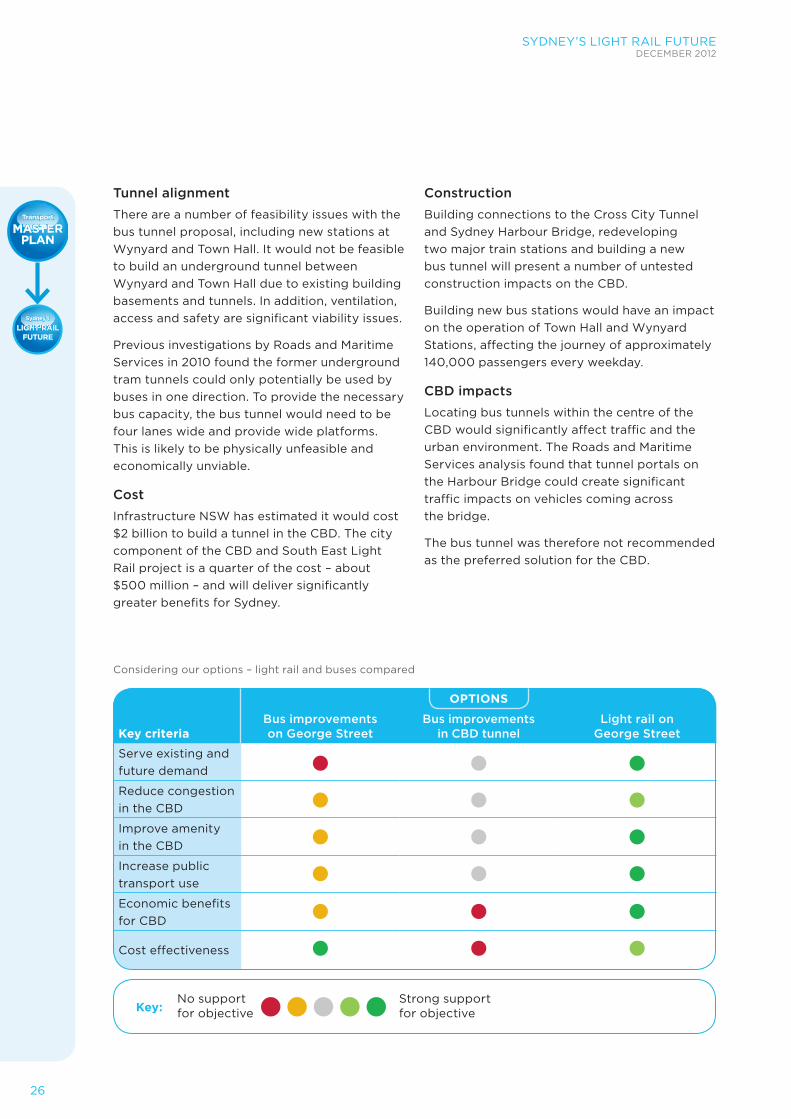
Considering our options – light rail and buses compared
OPTIONS
Key criteriaBus improvements on George Street
Bus improvements in CBD tunnel
Light rail on George Street
Serve existing and future demand
Reduce congestion in the CBD
Improve amenity in the CBD
Increase public transport use
Economic benefits for CBD
Cost effectiveness
Key:No support for objective
Strong support for objective


28
For more information visit www.transportmasterplan.nsw.gov.au