Sustainable Marine Environmental Information...
44
Sustainable Marine Environmental Information Services to Meet Collective European Needs Dr Peter Ryder CB FRMetS
Transcript of Sustainable Marine Environmental Information...

Sustainable Marine Environmental Information Services to Meet Collective
European Needs
Dr Peter Ryder CB FRMetS
EuroGOOS Personnel
EuroGOOS Publications
Secretariat Hans Dahlin (Director) EuroGOOS Office, SMHI, SwedenPatrick Gorringe (Project Manager) EuroGOOS Office, SMHI, SwedenSiân Petersson (Office Manager) EuroGOOS Office, SMHI, Sweden
Chair Peter Ryder
Board Sylvie Pouliquen Ifremer, FranceEnrique Alvarez Fanjul Puertos del Estado, SpainKostas Nittis HCMR, GreeceBertil Håkansson SMHI, SwedenJan H Stel NWO, NetherlandsGlenn Nolan Marine Institute, IrelandKlaus-Peter Kolterman IOC UNESCORoger Proctor Proudman Oceanographic Laboratory, UK
Regional Chairs Stein Sandven Arctic ROOSErik Buch BOOS (Baltic)Sylvie Pouliquen/Alicia Lavín IBI-ROOS (Iberia-Biscay-Ireland)Nadia Pinardi MOON (Mediterranean)Kees van Ruiten NOOS (North West Shelf)
1. Strategy for EuroGOOS 1996 ISBN 0-904175-22-72. EuroGOOS Annual Report 1996 ISBN 0-904175-25-13. The EuroGOOS Plan 1997 ISBN 0-904175-26-X4. The EuroGOOS Marine Technology Survey ISBN 0-904175-29-45. The EuroGOOS Brochure 19976. The Science Base of EuroGOOS ISBN 0-904175-30-87. Proceedings of the Hague Conference, 1997, Elsevier ISBN 0-444-82892-38. The EuroGOOS Extended Plan ISBN 0-904175-32-49. The EuroGOOS Atlantic Workshop Report ISBN 0-904175-33-210. EuroGOOS Annual Report 1997 ISBN 0-904175-34-011. Mediterranean Forecasting System Report ISBN 0-904175-35-9 12. Requirements Survey Analysis ISBN 0-904175-36-713. The EuroGOOS Technology Plan Working Group ISBN 0-904175-37-514. The BOOS Plan 1999-2003 ISBN 0-904175-41-315. Bio-ecological Observations in OO ISBN 0-904175-43-X16. Operational Ocean Observations from Space ISBN 0-904175-44-817. Proceedings of the Rome Conference 1999, Elsevier ISBN 0-444-50391-918. NOOS—Strategic Plan ISBN 0-904175-46-419. Proceedings of the Athens Conference 2002, Elsevier ISBN 0-444-51550-X20. The EuroGOOS Brochure 200421. The Policy Basis of the “Ecosystem Approach” to Fisheries Management ISBN 91-974828-1-122. The Arctic Ocean and the Need for an Arctic GOOS ISBN 91-974828-0-323. Proceedings of the Brest Conference, 2005, European Commission ISBN 92-894-9788-224. IBI-ROOS Plan: Iberia Biscay Ireland Regional Operational Oceanographic
System 2006–2010ISBN 91-974828-3-8
25. FerryBox: From On-line Oceanographic Observations to Environmental Information
ISBN 978-91-974828-4-4
26. Sustainable Marine Environmental Information Services to Meet Collective European Needs
ISBN 978-91-974828-5-1
Contents1 Conduct of the Study . . . . . . . . . . . . . . . . . . . . . . . . . . . . . . . . . . . . . . . . . . . . . . . . 12 Introduction . . . . . . . . . . . . . . . . . . . . . . . . . . . . . . . . . . . . . . . . . . . . . . . . . . . . . . . . 22.1 The MCS Strategic Implementation Plan (SIP) . . . . . . . . . . . . . . . . . . . . . . . . . . . . . . . . . . . . . . 22.2 Simulations – how to respond to ‘What if?’ questions . . . . . . . . . . . . . . . . . . . . . . . . . . . . . . . . . 2
3 The Purpose, Scope and Functionality of the MCS . . . . . . . . . . . . . . . . . . . . . . . . 43.1 Purpose . . . . . . . . . . . . . . . . . . . . . . . . . . . . . . . . . . . . . . . . . . . . . . . . . . . . . . . . . . . . . . . . . . . . 43.2 The nature of the MCS . . . . . . . . . . . . . . . . . . . . . . . . . . . . . . . . . . . . . . . . . . . . . . . . . . . . . . . . 43.3 The scope of the MCS and its rationale . . . . . . . . . . . . . . . . . . . . . . . . . . . . . . . . . . . . . . . . . . . 53.4 Marine Core Service Functionality . . . . . . . . . . . . . . . . . . . . . . . . . . . . . . . . . . . . . . . . . . . . . . . 83.5 The concepts of upstream providers, intermediate users and end users . . . . . . . . . . . . . . . . . . 9
4 The Strategic Implementation Plan . . . . . . . . . . . . . . . . . . . . . . . . . . . . . . . . . . . . 104.1 Principles and sources of guidance used . . . . . . . . . . . . . . . . . . . . . . . . . . . . . . . . . . . . . . . . . 104.2 System foundations . . . . . . . . . . . . . . . . . . . . . . . . . . . . . . . . . . . . . . . . . . . . . . . . . . . . . . . . . 104.2.1 Existing infrastructure . . . . . . . . . . . . . . . . . . . . . . . . . . . . . . . . . . . . . . . . . . . . . . . . . . . . . . . . 114.2.2 Relevant existing information services . . . . . . . . . . . . . . . . . . . . . . . . . . . . . . . . . . . . . . . . . . . 114.2.3 Past and current R&D projects . . . . . . . . . . . . . . . . . . . . . . . . . . . . . . . . . . . . . . . . . . . . . . . . . 124.3 The proposed strategy for the MCS and its application . . . . . . . . . . . . . . . . . . . . . . . . . . . . . . 134.3.1 Architecture of the MCS . . . . . . . . . . . . . . . . . . . . . . . . . . . . . . . . . . . . . . . . . . . . . . . . . . . . . . 134.3.2 Implementing the architecture . . . . . . . . . . . . . . . . . . . . . . . . . . . . . . . . . . . . . . . . . . . . . . . . . . 164.4 The roadmap for the required upstream observational components . . . . . . . . . . . . . . . . . . . . 174.4.1 The required space infrastructure: . . . . . . . . . . . . . . . . . . . . . . . . . . . . . . . . . . . . . . . . . . . . . . 174.4.2 The required in situ infrastructure . . . . . . . . . . . . . . . . . . . . . . . . . . . . . . . . . . . . . . . . . . . . . . . 194.5 Implementation of the MCS . . . . . . . . . . . . . . . . . . . . . . . . . . . . . . . . . . . . . . . . . . . . . . . . . . . 204.5.1 Data collection, assembly and quality control within the MCS . . . . . . . . . . . . . . . . . . . . . . . . . 204.5.2 Ocean modelling and data assimilation . . . . . . . . . . . . . . . . . . . . . . . . . . . . . . . . . . . . . . . . . . 224.5.3 Service generation, access, delivery and support . . . . . . . . . . . . . . . . . . . . . . . . . . . . . . . . . . 234.5.4 Standards . . . . . . . . . . . . . . . . . . . . . . . . . . . . . . . . . . . . . . . . . . . . . . . . . . . . . . . . . . . . . . . . . 254.5.5 Funding and Data Policy . . . . . . . . . . . . . . . . . . . . . . . . . . . . . . . . . . . . . . . . . . . . . . . . . . . . . . 264.5.6 Governance and related issues . . . . . . . . . . . . . . . . . . . . . . . . . . . . . . . . . . . . . . . . . . . . . . . . 264.6 Implementation of downstream services . . . . . . . . . . . . . . . . . . . . . . . . . . . . . . . . . . . . . . . . . . 284.6.1 Marine Environmental Strategy Directive and related Conventions . . . . . . . . . . . . . . . . . . . . . 294.6.2 Ice Services . . . . . . . . . . . . . . . . . . . . . . . . . . . . . . . . . . . . . . . . . . . . . . . . . . . . . . . . . . . . . . . 314.6.3 Oil spill monitoring . . . . . . . . . . . . . . . . . . . . . . . . . . . . . . . . . . . . . . . . . . . . . . . . . . . . . . . . . . . 33
5 Conclusions . . . . . . . . . . . . . . . . . . . . . . . . . . . . . . . . . . . . . . . . . . . . . . . . . . . . . . . 366 Appendix . . . . . . . . . . . . . . . . . . . . . . . . . . . . . . . . . . . . . . . . . . . . . . . . . . . . . . . . . 396.1 Characterisation of MCS variables and products . . . . . . . . . . . . . . . . . . . . . . . . . . . . . . . . . . . 39


Sustainable Marine Environmental Information Services to Meet Collective European Needs 1
The combined SEPRISE kick-off and GMESWorkshop on Services for Marine OperationalForecasting held in November 2004 generated a listof currently and soon to be available informationproducts and those which are required and thoughtto be feasible in the longer term. The Workshopalso agreed the essential components of ‘bestpractice’ in marine service provision and a numberof relevant recommendations.
At an early stage and subsequently, theSEPRISE Workshops have approved thestrategy of building a sustainable, integratedoperational system based on the GMES MarineCore Service (MCS), with integrated, coordi-nated upstream in situ and EO data provisionand downstream services dedicated to meetingindividual needs for services. The politicalmomentum of GMES, the selection of the marinedomain as one of the GMES Fast Tracks, the strongsupport of ESA and their Member States for thetransition to operational missions, the conviction ofthe oceanographic community that the architectureof an MCS is correct, based as it is on the highlysuccessful architecture for operational meteor-ology, and the strong European focus on environ-mental protection and climate change, helped tosustain this decision. Additionally, the GMES initi-ative came at a time when oceanographic sciencehad received substantial support from MemberStates and the Commission, through theFramework Programmes 5 and 6 and in the widerinternational community through programmes suchas WOCE and GODAE.
The EuroGOOS Chair, and author of this plan, wasappointed as chairman of the Marine Core ServiceImplementation Group (MCS_IG) followingacceptance of the Service as one of the three GMES‘Fast Tracks’, based on the successful kick-offmeeting during 27–28 October 2005. Most of 2006was taken up by preparation of a draft StrategicImplementation Plan and consultation on itsfindings and recommendations. The MCS StrategicImplementation Plan forms the basis of this plan.The strategy is elaborated in chapter 4 of this report.
To ensure that the MCS is user driven, the IG iscomposed of representatives of the EEA, OSPAR,EMSA, the Maritime Policy Task Force, the ESF,EUMETNET and EuroGOOS (through the chair).HELCOM and UNEP/MAP receive working
papers and reports and are able to comment asappropriate. ESA and EUMETSAT are observersand have attended most of the meetings. The IG hasformed working groups composed of members ofthe IG and participants in the MERSEA IP to carryout particular studies to guide its work. The IG metin plenary on 5 May, 26 June, 9 October and 23November 2006 to agree the issues to be addressed,allocation of responsibilities for the preparation ofworking papers, the line to take on the identifiedissues and to review draft documents. TheChairman took on the responsibility of:
• Drafting a number of the working papers and theFinal Report
• Presenting the emerging results to four meetingsof the GMES Advisory Council (GAC),composed of EU Member State representatives
• Consulting EuroGOOS members at the Annualmeeting held in Exeter during 15–16 November2005, the SEPRISE meeting held in Brusselsduring 12–13 January 2006, the SEPRISEWorkshops held in Stockholm during 28February – 1 March 2006 and in Limassol on 4October 2006, and the NOOS Annual meetingheld in Lowestoft on 5 September 2006.
• In recognition of the importance of the MarineEnvironmental Strategy as a driver for opera-tional oceanography, presentation of theemerging results of the work at a preliminarymeeting of European Marine Monitoring &Assessment (EMMA) WG held in Copenhagenduring 3–4 April 2006 and presentation of thethen draft MCS Strategic Implementation Planduring a further EMMA meeting in Copenhagenduring 23–24 October 2006.
The Chairman has also been active as an advisor tothe Commission on the conduct of the MERSEA IPand as a member of the Strategy Group of theMarCoast GSE for the Project Board and ESA.These roles have been useful in keeping abreast ofthese projects and their potential contribution tothis deliverable.
The MCS Strategic Implementation Plan waspresented to and was well received by the GAC at ameeting held in Brussels on 14 February 2007. It isnow providing guidelines for the preparation ofresponses to the FP7-SPACE-2007-1 call – seewww.gmes.info/183.0.html for more information.
1 Conduct of the Study
Introduction2
2.1 The MCS Strategic Implemen-tation Plan (SIP)1
The SIP provides guidelines and prioritisation forimplementation ratified by the GMES AdvisoryCouncil. This includes a strategy for the provisionand access of coordinated upstream EO and in situdata required by the MCS and some majordownstream services. In the short term it isenvisaged that the SIP will guide current R&D anddemonstration activities being pursued with EC andESA funding, in particular those that will be fundedwithin the Space Theme of FP7. It is hoped that theSIP will also provide a roadmap for a long-term,sustainable Marine Core Service able to support awide range of downstream services, some of whichcan be seen today but many of which will onlyemerge when the MCS is in place. With this inmind, an effort has been made to describe therationale for the guidelines and priorities, notsimply the proposals themselves. It is hoped thatthe MCS Strategic Implementation Plan will giveconfidence to the EC and Member States that theirexpectations of GMES in the marine domain have agood chance of being fulfilled and that theircontinued support is warranted.
To fulfil its mandate and build upon the conclu-sions of the initial Workshop, the IG has addresseda number of specific issues:
• The purpose, scope and functionality of theMarine Core Service, especially of its globaland regional components
• Links and interfaces between the MarineCore Service and downstream services,including the requirements of downstreamservices for MCS products, their dependenciesin terms of product delivery (timeliness, qualitycontrol, …) and the associated contractualissues
• The space infrastructure required by theMarine Core Service, including therequirement for and continuity of currentEuropean capacities (space and groundsegments) operated by EUMETSAT, ESA andnational agencies, and the possibilities for inter-
national cooperation (complementary or sharedcapacities)
• In situ infrastructure for the Marine CoreService, especially the requirement for andsustainability of European capacities and theircontribution to international systems as well asthe European coordination to manage thesecapacities
• Structure and governance of the Marine CoreService, including, for example, the sharing ofactivities and operational responsibilitiesbetween the service provision partners and theassociated service level agreement process,defined between the GMES ManagementAuthority, representing the MCS user commu-nities, and, for example, a MCS ProviderConsortium, including the impacts of thisservice level agreement on the consortiumpartner status and on service information policy.
The first two of these issues are fundamental to thedesign of the overall system and are reviewed atsome length in chapter 3 before the implementationroadmap is developed and described; the proposedresolution of the other identified issues is describedat the appropriate point in the roadmap.
2.2 Simulations – how to respond to ‘What if?’ questions Much policy-making raises questions of the kind‘What if we were to do x or y?’ as a precursor toformulating a response to the unwelcome impact ofa pressure. This requirement was identified at theOctober 2005 workshop and the overall systemneeds to respond to it.
The requirement can be met in a number of ways,but in essence, the capability is needed to runexperiments in which all of the important processesaffecting the outcome are mimicked and the conse-quences of the hypothesised action are tested.Scaled physical models can be used for this purposeto test the consequences of changing themorphology of an estuary for example, but on thescale of the oceans and seas, recourse has to bemade to numerical earth system2 models of suffi-cient scope to internalise all the importantprocesses and feedbacks between them. Themodels developed to assimilate data and model
2 Introduction
1. GAC/2007/7

Sustainable Marine Environmental Information Services to Meet Collective European Needs 3
oceanographic processes for the MCS are certainlycapable of mimicking internal processes suffi-ciently well and therefore test the consequences ofpossible changes to inputs, e.g. of the consequencesof large-scale changes to nutrients from land-basedsources, but they are not designed for this purpose.
Fortunately suitable world class earth systemmodels have been developed and do exist withinEurope – to assess the consequences for climate ofincreased greenhouse gas emissions and deforest-ation for example. The obvious strategy is not toattempt to replicate such (major) capabilities but forthe intermediate and downstream users to contractout for them when required. That approach isadvocated.
2. In general such models need to embrace the important,relevant processes on/in the land, sea, cryosphere andatmosphere, and interactions between them.
The Purpose, Scope and Functionality of the MCS4
3.1 Purpose The purpose of the MCS is to make availableand deliver a set of basic, generic services basedupon common-denominator ocean statevariables that are required to help meet theneeds for information of those responsible forenvironmental and civil security policy making,assessment and implementation.
The Policy drivers have been identified as:
• Regional Conventions between Member Statesand the EC – OSPAR/HELCOM/Barcelona
• 6th Environmental Action Plan; in particular itsClimate Change and Marine EnvironmentalStrategy3 components
• The Sustainable Development imperative whichis written into the Rome Treaty and is now beingdeveloped through the Green Paper on MaritimePolicy4
• Relevant existing EU Directives, such as theWater Framework Directive in its application tocoastal waters
• Concerns over civil security which manifestthemselves in two broad ways. Firstly over thesafety of life and property in the marineenvironment, and through the recognition thatwhilst there are risks to be managed throughwell designed warning systems, defences andother preventive measures, major naturalhazards and man-made accidents will occur thatalso need to be managed. The Prestige accidentin 2003 and flooding in Holland and England in1953 and in New Orleans in 2005 are examples.Secondly, the concept of civil security, in the
sense of protection against illegal activities,clearly exists as a driver for GMES and hencefor the MCS and appropriate downstreamservices. However that concept has not yet beendeveloped beyond the realisation that any suchprotection requires maritime surveillance andmeans of vessel identification and tracking, aswell as the actual and forecast state variables tobe provided by the MCS.
All of these require long-running data sets to definethe mean state5 of the marine environment, fluctua-tions about that, past trends and future predictionsof change (particularly in an era of uncertaintyabout climate) to establish baselines for environ-mental management and design criteria for struc-tures operating in the environment. In addition,short range predictions (out to several days ahead ingeneral and with a few hours lead time with greateraccuracy) are required particularly of hazardousconditions, but also for the efficient conduct ofevery day operations.
The MCS must be designed and implemented tomeet these needs in a reliable, easy-to-use, opera-tional6 manner, with information of usefulprecision and stability.
The Lisbon agenda is also an important policy initi-ative for GMES as a whole, noting that theprogramme is included in the Quick StartProgramme and expected to foster the creation ofnew, innovative information-based services andknowledge.
3.2 The nature of the MCSThe information services required to fulfil thispurpose need to have global and pan-Europeanscope. The variables about which information isprovided will be domain-specific; i.e. likely to varybetween the regional seas and global oceans andbetween high and mid latitudes.
3 The Purpose, Scope and Functionality of the MCS
3. See section 4.6.14. The Maritime Policy Green Paper has emphasised that
commercial sectors such as shipping, fishing, oil explo-ration, offshore construction, aquaculture, and tourism, andpublic sectors such as coastal protection, defence, searchand rescue, R&D and government policy-making all needdata on past, present and future meteorological, oceano-graphic, hydrographic and ecological state of the seas andthe oceans. Global-scale monitoring is required to meet thisneed and the EU is being encouraged to set up a EuropeanMarine Observation & Data Network to provide sustainable,improving access to information. EuroGOOS has respondedto the Green Paper by suggesting that the MCS and itsupstream and downstream components provide an excellentbasis for that.
5. Here we mean the physical, biological and chemical state ofthe environment, in general. The need for the biologicalcomponent is likely to be expressed in terms of the state ofecosystems, and habitats; the chemical component in termsof pollutants and nutrients.
6. Here we mean having guaranteed availability to meet userneeds.
Sustainable Marine Environmental Information Services to Meet Collective European Needs 5
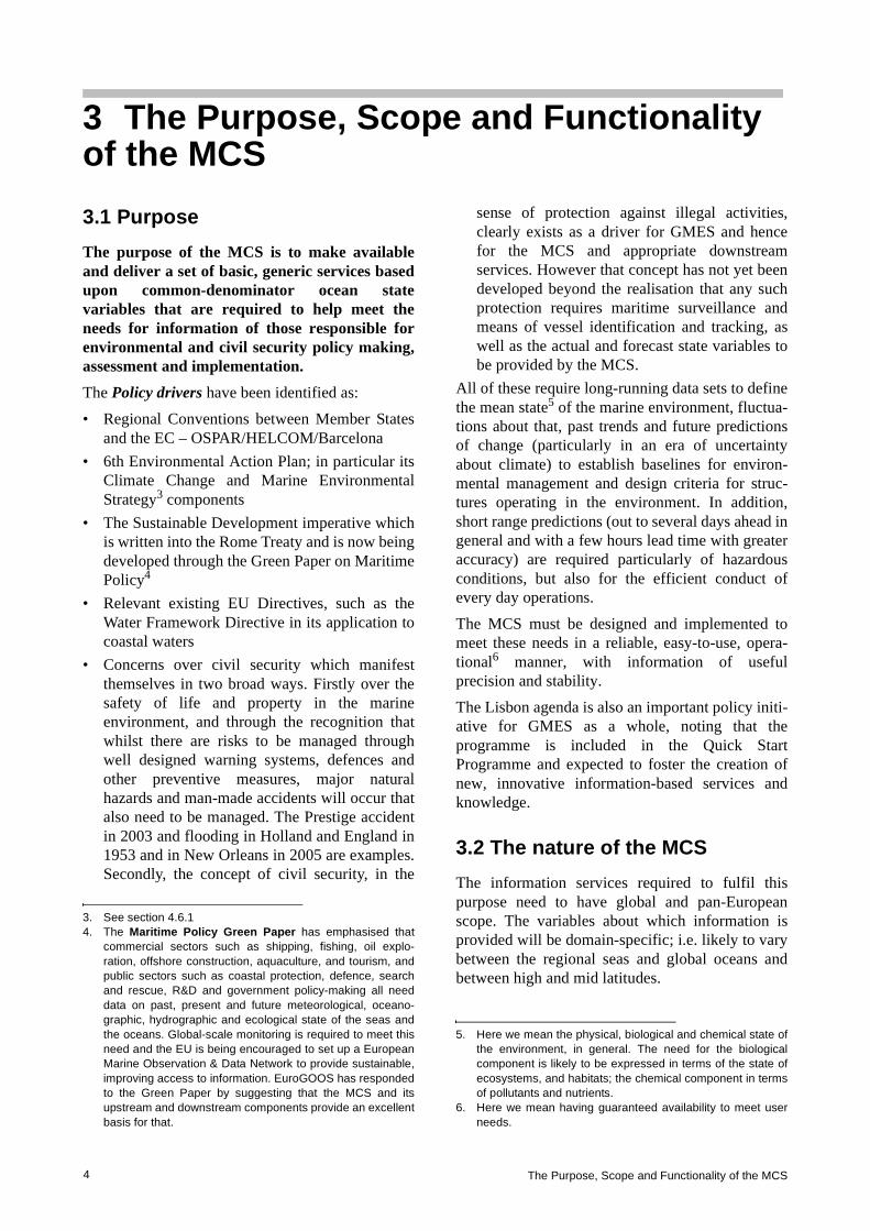
The MCS is conceived as one part of a processingchain which operates on observational and otherforms of data to help create tailored informationservices to meet a wide range of end user needs.Almost all such end user services relating to themarine environment require access to informationabout the state and dynamics of the oceans andseas. The MCS provides that information to inter-mediate users who combine this with other forms ofinformation and data to provide customiseddownstream services for end users. The concept isillustrated in Figure 1 and further elaborated insection 3.2.
The implementation of the overall chain needs tohave some flexibility. As components ofdownstream services are developed to servemultiple uses, it may be more efficient for them tobe provided as part of the MCS.
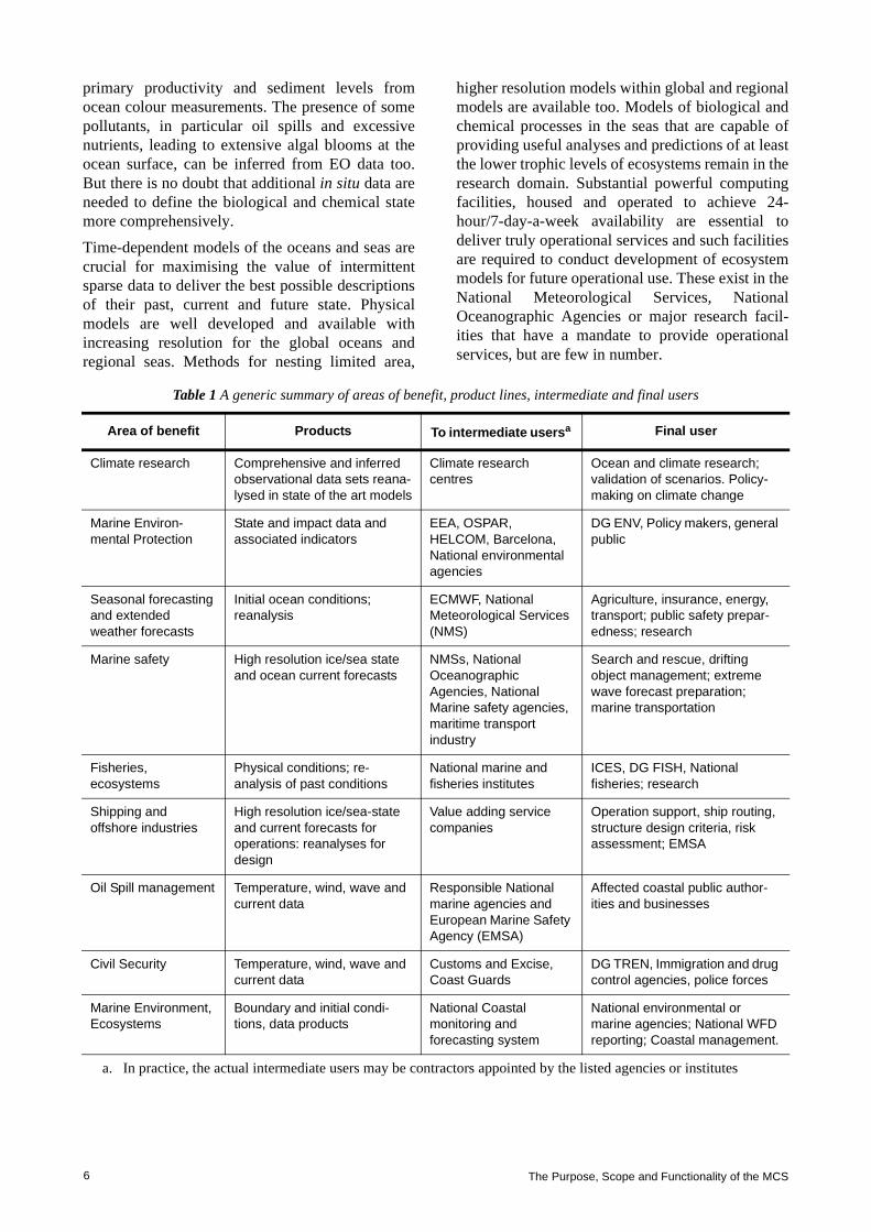
The envisaged MCS variables and products aredescribed in the Appendix. The applications / areasof benefit that these are capable of serving areindicated in Table 1.
3.3 The scope of the MCS and its rationale At the present time it is entirely feasible, withuseful accuracy, to describe the physical state of the
oceans and seas, including the relevant dynamics,from the surface to the sea floor, provided thatrepresentative data are available to:
a) resolve the main dynamical and physical charac-teristics sufficiently often to span the period ofuseful predictability of current numericalmodels (a few weeks)
b) describe the forcing from the atmosphere. It is valuable, and for some purposes and locationsessential, to know the extent and nature of ice coverand the flux of fresh water from the major rivers.The nature of the bottom topography is clearlyimportant but that is sufficiently well known, on thebroad scale at least.
Some in situ measurements are available fromresearch vessels to characterise the biological andchemical state of the seas but these are often sparsein time and space and tend to be concentrated incoastal waters. They are rarely available in nearreal-time7. They do allow identification of longperiod trends at (hopefully) representativelocations. Some limited properties can be inferredmore frequently and extensively from EO data, e.g.
GMESsatelliteandin situnetworks
Inputsfromotherdatasources
GMES inputdata
MCS information(ocean state,
forecast)
Customised enduser information
MarineCore
ServiceProvision
MultipleDownstream
Service Provisions
Functions of Marine Core Services• Production and delivery of ocean products• Monitoring performance of the system • Quality assurance • Data management• User management• R&D
Products• Global, EU regional seas• Physical ocean and primary ecosystem• State and forecast
Downstream servicesand end user domain, eg• Marine safety• Oil spill management• Marine resources• Climate change• Coastal management• Polar operations
INTERFACE
Interface services• Discovery• View• Download• Scheduled delivery
IntermediateUsers
End users
Intermediateusers
End Users
Other data sources
Figure 1 the position of the MCS in the overall chain of service delivery from GMES input data to the provision of multiple information services to end users.
7. Some moorings and the FerryBox technology are capable ofnear real-time biogeochemical reporting. New technologiessuch as gliders and ARGO floats can also collect biogeo-chemical data and are very promising for the provision ofnear real-time data.
The Purpose, Scope and Functionality of the MCS6
primary productivity and sediment levels fromocean colour measurements. The presence of somepollutants, in particular oil spills and excessivenutrients, leading to extensive algal blooms at theocean surface, can be inferred from EO data too.But there is no doubt that additional in situ data areneeded to define the biological and chemical statemore comprehensively.
Time-dependent models of the oceans and seas arecrucial for maximising the value of intermittentsparse data to deliver the best possible descriptionsof their past, current and future state. Physicalmodels are well developed and available withincreasing resolution for the global oceans andregional seas. Methods for nesting limited area,
higher resolution models within global and regionalmodels are available too. Models of biological andchemical processes in the seas that are capable ofproviding useful analyses and predictions of at leastthe lower trophic levels of ecosystems remain in theresearch domain. Substantial powerful computingfacilities, housed and operated to achieve 24-hour/7-day-a-week availability are essential todeliver truly operational services and such facilitiesare required to conduct development of ecosystemmodels for future operational use. These exist in theNational Meteorological Services, NationalOceanographic Agencies or major research facil-ities that have a mandate to provide operationalservices, but are few in number.
Table 1 A generic summary of areas of benefit, product lines, intermediate and final users
Area of benefit Products To intermediate usersa Final user
Climate research Comprehensive and inferred observational data sets reana-lysed in state of the art models
Climate research centres
Ocean and climate research; validation of scenarios. Policy-making on climate change
Marine Environ-mental Protection
State and impact data and associated indicators
EEA, OSPAR, HELCOM, Barcelona, National environmental agencies
DG ENV, Policy makers, general public
Seasonal forecasting and extended weather forecasts
Initial ocean conditions; reanalysis
ECMWF, National Meteorological Services (NMS)
Agriculture, insurance, energy, transport; public safety prepar-edness; research
Marine safety High resolution ice/sea state and ocean current forecasts
NMSs, National Oceanographic Agencies, National Marine safety agencies, maritime transport industry
Search and rescue, drifting object management; extreme wave forecast preparation; marine transportation
Fisheries, ecosystems
Physical conditions; re-analysis of past conditions
National marine and fisheries institutes
ICES, DG FISH, National fisheries; research
Shipping and offshore industries
High resolution ice/sea-state and current forecasts for operations: reanalyses for design
Value adding service companies
Operation support, ship routing, structure design criteria, risk assessment; EMSA
Oil Spill management Temperature, wind, wave and current data
Responsible National marine agencies and European Marine Safety Agency (EMSA)
Affected coastal public author-ities and businesses
Civil Security Temperature, wind, wave and current data
Customs and Excise, Coast Guards
DG TREN, Immigration and drug control agencies, police forces
Marine Environment, Ecosystems
Boundary and initial condi-tions, data products
National Coastal monitoring and forecasting system
National environmental or marine agencies; National WFD reporting; Coastal management.
a. In practice, the actual intermediate users may be contractors appointed by the listed agencies or institutes
Sustainable Marine Environmental Information Services to Meet Collective European Needs 7
With these caveats, and the hope that continuityof EO data can be maintained and in situmonitoring improved, it is clear that an MCSthat can fulfil its purpose, given the availabilityof the necessary computing, data collection andprocessing facilities and skilled staff to operatethem.
The descriptions above provide necessary butinsufficient criteria to define the scope of apractical, deliverable MCS. It is also necessary toplace some limits on the areal extent and resolutionof common services to be provided as part of theMCS and those which will be more properly andefficiently provided as downstream services – seebelow. There are strong arguments (see section4.3.1) for recognising the particular characteristicsand needs for MCS products on a global scale, forthe oceans which border Europe and their shelf andregional seas. But the needs for descriptions of thephysical, biological and chemical state of everyestuary or coastal zone cannot be met by the MCS.This would require high resolution models of everyEEZ to be maintained and operated when needed,for example to predict the evolution of majoraccidental releases of pollutants as part of the MCS.There are important specialised, normally national,needs such as these which should be met bydownstream services, coordinated where necessaryat a regional or EU level. Such services will besupported by the MCS through the provision ofbroader scale state descriptions, in particular in theform of the boundary and initial conditions for highresolution models of coastal or otherwise defineddomains of interest.
The rationale for this conclusion is both politicaland economic.
Firstly, the principle of subsidiarity notes that:“nothing should be done by a larger and morecomplex organisation which can be done as well bya smaller and simpler organisation”. The archi-tecture that is proposed in section 4.3.1, a system ofsystems, from global to regional, follows that tenet.The coastal domain, where the greatest diversity ofend users arises, is not considered part of the MCS,since it can be served most effectively at a nationaland local level by downstream services. If the MCSwas to maintain the capability to provide diverse,high-resolution services everywhere, for allpossible purposes requiring information about thecommon denominator state variables, it would needto be a very large and complex organisation.Furthermore, it would still be necessary for theMCS to interface with intermediate users tocombine the state variables with all other local
information necessary to resolve real social,economic and environmental issues, so there wouldbe few savings and the potential for complex,unmanageable interfaces. This is not to deny thatsome of the ‘front end’ functions of the MCS (seesection 4.5.1) could and should not be carried out atregional centres, particularly where they can makeuse of existing capabilities.
Secondly, the substantial investment that will beneeded to provide MCS services requires thenumber of computer-intensive modelling/dataassimilation centres at least to be kept to aminimum, consistent with the recognised large-scale variation in the global and regional Europeanoceans and seas and a desire for some technicalcompetition at the margin. The envisaged consoli-dation and integration to relatively well-equippedcentres brings the potential for improved value formoney and scientific quality, as well as robustnessto the system. In the spirit of the EuropeanResearch Area, the integration of the MCS can playa significant role in drawing the intellectualresources and tapping the expertise of a widecommunity. The Workshop which led to thedecision for Fast Track MCS implementation,and much prior discussion, recognised this andconcluded that the number of such centresshould be of order 10. Provided that informationfrom the MCS is freely and readily available forfurther elaboration in downstream services andthere is a sharing of tools, that conclusion wasupheld by the IG and is an integral part of thisplan. This will release public and privatedownstream service providers from the need toduplicate the services provided by the MCS andenable them to focus on the many localised,tailored services that are required by end users.
The intention to provide significant EU fundingthrough the FP7 Space Programme to support thefurther development and demonstration of theMCS, whilst investment in downstream serviceprovision is likely to fall mainly to Member Statesand commercial organisations, provides a counter-vailing pressure to maximise the size and scope ofthe MCS. The IG believed this pressure to be unfor-tunate because it could deliver an unsustainableoutcome in the long term unless managed carefully.It would be a huge mistake to support developmentand demonstration of a multiplicity of pre-opera-tional systems (potentially with sub-optimalperformance) through FP7 which could not besustained. This again argues for an MCS which isas small as necessary to deliver its fundamentalpurpose at the European scale. This is not to deny

The Purpose, Scope and Functionality of the MCS8
the need to build up expertise in Member States touse the MCS information for their specific needs.The issue of funding is discussed further in section4.5.5.
3.4 Marine Core Service Function-alityRecognising that the MCS must collect, quality-control and process data, using numerical modelsand standard analytical tools, to produce anddeliver hindcasts, analyses and forecasts, therequired operational functions of an MCS are asillustrated in Figure 2.
Briefly the functions are to:
• Acquire data from the ground segment of thespace-based observing systems and in situnetworks. Typically these will be at level 1 or 28
• Acquire atmospheric forcing data (atmosphericwinds, temperatures, fluxes) from NMSs andECMWF
• Assemble these into QC thematic datasets (i.e.specific data types such as sea surface temper-ature, salinity profiles…) suitable for the gener-ation of more extensive data sets for subsequentuse, analytical products and assimilation byocean models. Much of this has to be carried outin near real-time, but data of the highest qualitycan be assembled in slower time
• Run numerical ocean models in near real-time toassimilate the thematic data and generateanalyses and forecasts from them to an agreedand generally perpetually repeating cycle, whichuses information from earlier forecast cycles aswell as the most recent thematic data. Thecentres also need to operate off-line to producereanalyses / hindcasts from the high quality data
Collect/receive, quality control, assemble into
thematic types & distribute in situ
data @ level 1- 2
Collect/receive, quality control, assemble into
thematic types & distribute EO
data@ level 1-3
Receive, process & distribute atmospheric forcing data
Receive, quality control, form data sets and archive for non-
real time use Interface to enable
cataloguing search, view, download & scheduled delivery of products to intermediate
users
Validation & Quality Assurance
User tools & training
Product interpretation Underpinning research and development
Receive and assimilate data into global and regional
models to produce analyses and forecasts in a perpetual cycle and offline to generate
hindcasts
Figure 2 The essential functions of an MCS
8. CEOS has defined a number of data/product levels for usein Earth Observation. It is helpful to use a common nomen-clature in discussing data processing. Level 0 Data: Raw data after restoration of the chronologicaldata sequence for each instrument, i.e. after demultiplexingof the data by instrument, removal of any data overlap dueto the data dump procedure and relevant quality checks.Raw instrument data information (telemetry packets) ismaintained during this process.Level 1a Data: Instrument data in full resolution with radio-metric and geometric (i.e. Earth location) calibrationcomputed and appended but not applied.Level 1b Data: Calibrated, earth located and qualitycontrolled data, expressed as radiance or brightnesstemperature, in the original pixel location, and packagedwith needed ancillary, engineering and auxiliary data.Level 1c Data: In case of the IASI spectra, level 1b data afterapplication of the apodisation function.Level 2 Product: Earth located pixel values converted togeophysical parameters, at the same spatial and temporalsampling as the level 1b data.Level 3 Product: Gridded point geophysical products on amulti-pass basis.Level 4 includes the use of other data sources, e.g. modelresults etc.

Sustainable Marine Environmental Information Services to Meet Collective European Needs 9
• Prepare products suitable for external serviceprovision at the ‘Interface’ shown in Figure 1and Figure 2. That interface must havediscovery and viewing capabilities and theability to download specific products inresponse to requests. It must also be able todeliver, probably quite large volumes of data,routinely to an agreed schedule to meet theneeds of specific intermediate users.
The required support functions are elaboratedfurther in section 4.5.3; they are essentially tomonitor and validate the performance of the MCSto assure the quality of its products, providecustomer support in the form of interpretive toolsand training, and prioritise and oversee the researchand development needed to sustain the MCS.
3.5 The concepts of upstream providers, intermediate users and end usersThe division into upstream and downstreamcomponents of the service chain is based on theimperative “to produce information once but use itmany times” for specific public or commercial enduser applications. Not all environmental infor-mation services are suitable for delivery in thisway, but wherever there is a need for informationabout the current or predicted future state of theenvironment, widely defined, it makes sense to tryto meet this once rather than many times. This isparticularly true when, as here, substantialresources (computers and skilled people) areneeded to assemble basic state data, assimilatethem and use high-resolution, complex models topredict future states. This lesson has been learnedand applied extensively in operational meteorologyand recent research has demonstrated that it isequally applicable to operational oceanography.Figure 1 exemplifies the chosen architecture of thechain.
Upstream providers collectively comprise theproviders of relevant EO and in situ data andatmospheric forcing information required by theMarine Core Service and directly by the interme-diate users – see below. In simple terms it isexpected that these upstream providers will:
• Develop, construct and operate the space andground based facilities necessary to deliver therequired data; in fulfilling the delivery function,they will calibrate instrument measurements andconvert them to geo-located estimates ofgeophysical, chemical or biological variables(i.e. generate level 2 data sets)
• In some areas produce coherent, qualitycontrolled data sets, possibly from multiplesources (i.e. generate level 3 products).
The purpose of the MCS is set out in section 3.1and the required functionality is described insection 3.4.
The intermediate users are recipients of the dataand products generated by the MCS from thecombined use of atmospheric forcing informationand basic in situ and EO data, models and dataassimilation. Typically they will generate infor-mation services that downscale the larger scaleMCS products to the local scale and increase thenumber of analysed, predicted state variables at thelocal level to meet needs. Therefore, such serviceswill generally require the capture of additionalforms of data to deliver economic or societalbenefit. Typically such additional data might behigh-resolution meteorological forcing in deliv-ering storm surge predictions, socio-economic in apolicy development context, pressures (e.g. catchand fisheries effort data) to set alongside statevariables from the MCS to understand observedenvironmental impacts, assets at risk in managing ahazardous event, vessel identification and trackinginformation for maritime surveillance, etc. Theresulting information services are downstreamservices. It is recognised that downstream servicestoday might become core services in future, asmultiple uses are found for particular data sets andtypes of information. Therefore the definition ofthese two service streams has been couched ingeneral terms to provide flexibility in future.
Ultimately the public will validate, or not, thebenefit of these services. But, as characterised inTable 1, in general end users can be categorised as:
• Governmental departments/agencies, at EU orMember State level, that require marineproducts and information for developing andvalidating policies respectively (e.g. DGEnvironment, DG Fish, DG TREN, NationalDepartments of Environment, …)
• “Public downstream services” that actuallyimplement public policies, and are frequentlypart of the mandate of national agencies (e.g.flood risk managers, environmental protectionagencies)
• Providers of maritime services of various kinds,(e.g. shipping, port operations, coast guards …)
• Commercial and industrial end users (e.g.offshore oil, gas and aggregate extractioncompanies, fishing companies, …).

The Strategic Implementation Plan10
4.1 Principles and sources of guidance used In developing proposals for an MCS supplied byupstream data providers and able to supply interme-diate users with the common denominator productsthat they require, the IG adopted a number ofprinciples:
a) GMES is a joint initiative of the EC, ESA andMember States so it is assumed that all have avested interest in its success, judged by thevalue of the information services that it delivers,and will be willing to commit commensurateresources and adapt working practices toachieve that success.
b) To be judged successful in these terms, the MCSmust be genuinely driven to support interme-diate users on behalf of their end users, all ofwhom will appreciate the value of its servicesand be able to determine its output and influenceits evolution.
c) Given the impossibility of operating an IGcontaining a large number of users, representa-tives from EEA, EMSA, EUMETNET,EuroGOOS and the Maritime Policy Task Forcehave federated intermediate and end user needs.They were able to draw on their own andcolleagues’ experience of existing services inMember States and from relevant ESA GSEs.
d) The MCS must be designed and implemented tomeet identified needs in a reliable, easy-to-use,operational manner, with information of usefulprecision and stability.
e) There is considerable scope for integration andcoordination of existing efforts.
The MCS must:
• make maximum use of past investment andexisting facilities
• be sustainable on an operational basis, withappropriate governance and funding built intothe system.
Guidance has been obtained as follows:
a) Advice on scientific/technical matters and prior-ities for R&D from the ESF
b) Current user needs and experience in meetingthem from EuroGOOS members and their publi-cations, the EEA and EMSA
c) Proffered national guidance and proposalsd) Published material on best practice from GOOS,
GCOS, and Regional Conventionse) Findings and capabilities developed from FP5/6
projects: the MERSEA IP in particularf) The experience of the ESA GSEs: MarCoast and
Polar View in particularg) Experience from EUMETNET in generating
efficiencies through collaborative efforts: inparticular in coordinating in situ observingsystems.
4.2 System9 foundationsIn keeping with the imperative to ensure that theneeds of end users are understood and acted upon,and to make maximum use of past investment andexisting facilities, these matters have beenreviewed to establish sound foundations uponwhich to build the System.
The identified needs are summarised in section 3.1and the Appendix.
The System foundations can be characterised as:
a) The existing infrastructure in the form of in situobserving systems, EO systems and datacollection and modelling systems that are inplace to provide environmental informationservices
b) Those information services themselvesc) Previous and current R&D projects that have or
are delivering relevant understanding, tools andcapabilities – including but not limited to theOperational Forecast Cluster of FP5/6.
The IG’s task of gaining an appreciation of thesefoundations and that of SEPRISE has been greatlyaided by the proceedings and papers of the fourtriennial EuroGOOS conferences, stretching backto 1996.
4 The Strategic Implementation Plan
9. In this context the System comprises the upstream dataprovision, MCS and intermediate users providingdownstream services.

Sustainable Marine Environmental Information Services to Meet Collective European Needs 11
4.2.1 Existing infrastructure Existing infrastructure was identified in the formof:
• In situ observing systems funded by MemberStates to meet national needs, e.g. for defence,safety and environmental protection, to fulfilnational obligations under Regional Conven-tions and Directives, sustain researchprogrammes and participate in internationalprogrammes partially funded by non-EU states.Generally these have not been designed formultiple uses and the research programmes arerarely funded on other than a short term basis.They do tend to use the technologies listed insection 4.4.2, to a variable extent. Any coordi-nation that takes place seems to be on an ad hoc,best endeavours basis, based on the premise thatthe sum of the parts will probably represent asatisfactory outcome. The SEPRISE project hasestablished that monitoring sites are generallyplaced to serve very local needs, that theresulting networks are of highly variable density(see Figure 6) and there is little natural incli-nation to exchange data beyond near neigh-bours, although the project has demonstratedthat wider regional exchange can be facilitatedin practice.
• Space-based Earth Observation systems fundedby Member States via their respective ESA andEUMETSAT membership, or through nationalprogrammes. The investments are used tosustain research programmes, meet operationalneeds, e.g. in defence and meteorology, developand demonstrate technology, improve industrialcapacity and build markets. Access is alsogained on various terms to EO systems fundedand operated by non-European Space Agencies.The resulting data are used for utilitarianpurposes.For the marine domain, the technologies that areused and the data requirements and priorities areshaped by the requirement to monitor state, asdescribed above, and what it is feasible tomeasure to useful accuracy from space-basedinstruments. Appendix 3 of GAC/2007/7 andsection 4.4.1 of this report characterises currentneeds, on the basis of the demonstrated capabil-ities of the current infrastructure. The key issueis that, with the exception of the (EU and non-EU) meteorological (and inaccessible defence)systems, none of the current systems capable ofmeeting these needs are truly operational. As aresult, continuity of data supply cannot beguaranteed. This apart, Europe has access to all
the necessary capabilities and technologies tomeet those needs, in particular through ESA andits Member States and their commitment toGMES.
• Ocean Modelling funded by Member States tomeet national needs, e.g. for defence, safety andenvironmental protection and to sustain researchprogrammes. There are large numbers of thelatter, built firstly for research purposes, impos-sible to describe in a plan such as this, andarguably with an uneasy connection to the needsdescribed in section 3.1, other than through theresults of those research programmes. Thosethat are relevant to implementation of the plan,i.e. capable of being operated operationally, areidentified with their attending data managementinfrastructure in section 4.5.2. It is important torecall again that models that have the necessary,demonstrated performance capabilities requiremajor investment in very powerful computingfacilities that are sufficiently robust (e.g. withappropriate attention being paid to backed-uppower supplies and telecommunication linksand to staffing). There are rather few of theseand most are linked in some way to the meteoro-logical services.
• Operational information dissemination of thereal-time component and high-volume satelliteand model output at least is always going to bean issue. Fortunately this is not a problem whichis unique to the System and so the presumptionhas to be that it will be solved through the use ofexisting commercially or otherwise availablesolutions – not through bespoke methods. TheEUMETCAST facility is an operational facilitycurrently available for distribution of the SAFdata referred to below. The internet provides asuitable vehicle for the exchange of smallamounts of data in the form of ftp files and forthe discovery/view functions – see section 4.5.3.
4.2.2 Relevant existing information services Relevant existing information services includethose provided:
• As public goods by Member State agencies forinternational Conventions such as HELCOM,OSPAR, Barcelona and ICES and for/via theEEA, for example as environmental or climateassessments
• As public goods by Member State agencies inthe form of national environmental assessmentsand to help secure safety of life and property.Typically the core information services for the

The Strategic Implementation Plan12
latter are provided by the National Meteoro-logical Services for elaboration in downstreamservices by national agencies according to theirparticular mandates (e.g. flood riskmanagement, pollution control, etc.)
• as public and private goods provided byEuroGOOS (www.eurogoos.org/) agencies,some of whom provide prototype MCS-type anddownstream services, e.g. as analyses (andjointly with others in the form of the dataservices provided by SeaDataNet) and model-based forecasts of sea level, temperature andcurrents for the regional seas, oil slick and algalbloom forecasts
• as thematic data services by European agenciesfor their Members, e.g. the EUMETSAT Ocean& Ice SAF (www.osi-saf.org/), ocean forcinginformation by ECMWF, marine observationsby EUMETNET and the ESA rolling archiveproviding access to products obtained from theERS and ENVISAT missions
• as service demonstration projects deliveringrelevant geo-information on an operational basis(e.g. ESA GSEs: Polar View(www.polarview.org/) for ice services andMarCoast (marcoast.info/) for oil spill and waterquality services)
• as private goods by public and private organisa-tions offered to their customers to confercommercial advantage, e.g. for enablingincreased efficiency and/or effectiveness(offshore industries, transport).
All of these have some lessons to offer and providepoints of departure for the System design. Inparticular:
• The high and known quality of the data requiredto meet the legal requirements of the Conven-tions
• The tested architecture of the MeteorologicalServices provision as a useful model for that ofthe MCS and its downstream services
• The value of the critical mass and the resultingworld class performance that can be achieved bycarrying out some functions at a European level
• The possibility of creating and satisfyingmarkets by tailoring and fusing data withinspecialist services, particularly where these canbe served, in part at least, by core informationgenerated once and used many times.
There are difficulties too. As far as the Conventionsare concerned, the time between “sampling events”and publication of assessed results is presentlyabout three years. The involvement of an opera-
tional MCS, as described in section 4.6.1, may beable to reduce this delay.
4.2.3 Past and current R&D projects Some of these were funded within the 5th and 6thFramework Programmes, others through ESA or bynational investment. It is neither necessary norpossible in this plan to describe them all but thefollowing examples have contributed substantiallyto the building blocks of an effective, efficientMCS and the associated upstream observingsystems and downstream services.
From the Framework Programmes, in the formof:
• Observing systems foundations – EDIOS,ODON
• In situ observing systems – GYROSCOPE,ANIMATE, BRIMOM, FerryBox
• EO-based observing systems – SOFT,GAMBLE
• Capacity Building – MAMA, PAPA, ARENA,GRAND
• Sea-level monitoring – GAVDOS, ESEAS-RI• Safety of Shipping – MaxWave, IRIS• Ice Services – DAMOCLES• Pre-operational pilots – TOPAZ, IOMASA,
MFSTEP• GMES preparations – MerSea Strand 1,
OCEANIDES• Integrated Projects – MERSEA, ECOOPThe MERSEA IP is currently developing anddemonstrating the capabilities required of an MCSas discussed further in sections 4.5.1 – 4.5.3.
From ESA projects:
• Medspiration – developing a European servicefor near real-time precise sea surface temper-ature
• GlobColour – developing a European service forocean colour.
The GODAE Sea Surface Temperature PilotProject (GHRSST-PP) is a good example of aninternational project that has spun up a globalservice, with European contributions from theMedspiration project and EUMETSAT Ocean &Sea Ice SAF, and which now provides an excellentbasis for a truly operational, comprehensiveEuropean SST service within the MCS, to mirrorthe US Global Data Analysis Center (GADC).
In addition there have been innumerable nationalR&D projects which have developed relevant

Sustainable Marine Environmental Information Services to Meet Collective European Needs 13
specific capabilities, many of which are nowcontribute to operational services. These include:
• MERCATOR (France) – global and regionalmodels
• FOAM (UK) – global and regional models• Coriolis (France) – a data management system• MONCOZE (Norway) – for coastal
environment management• SmartBuoy (UK) – in situ physical, biological
and chemical monitoring• Alg@line (Finland, Estonia) – automated ship-
borne monitoring• Seatrack Web (Sweden/Denmark) – an oil drift
forecasting system• POL (UK) – a coastal observatory• POSEIDON (Greece) – an in situ monitoring
and forecasting system• ADRICOSM (Italy) – an in situ monitoring and
forecasting system for the Adriatic Sea.All of these have brought or are bringing some newinsights and tools of relevance to operationaloceanography and hence to the MCS anddownstream services. Unsurprisingly the recentMERSEA IP is of particular importance in devel-oping and demonstrating capabilities that are offundamental importance to an operational MCS.Much of the ensuing design is based on the exploi-tation of those capabilities and lessons learned.There is more to do to develop observing systems,other data collection mechanisms and forms (e.g.surveys) and models to provide the information forsoundly-based ecosystem management and theECOOP IP is needed to help push these capabilitiesfurther towards the coast. It is very important thatthe MCS, as an operational system, has a closelycoupled R&D programme – another importantlesson learned in operational meteorology, andelsewhere.
4.3 The proposed strategy for the MCS and its applicationThe requirement is to be responsive to intermediateusers and, through them, to end users, who willrespectively deliver and use the informationgenerated as outlined below to inform policy-making, validation and implementation in the areasoutlined in section 4.2.1. The chosen strategy toaccomplish this is to build on the foundationsdescribed above by making maximum use ofexisting systems and past investment in knowledgeand tools. The existing systems are distributed so
the design of the System must be distributed. Ineffect a system of largely existing systems andthose under development will be the goal.
The strategy must then be to analyse the requiredfunctionality of the component systems to establishwhether and if so where they exist or might easilybe upgraded to perform as required. The reports ofthe WGs on the space-based and in situ infrastruc-tures are used for this, together with otherknowledge and insights obtained as discussed insection 4.1. Remaining gaps are identified, at leastin functional terms and hopefully with some candi-dates to fill them. Where possible a road map forthat process is suggested and priorities are estab-lished and recommendations made.
The suitability of the strategy is demonstrated insection 4.6 through a small number of end-to-endcase studies of its envisaged application.
4.3.1 Architecture of the MCSThe key step is to recognise that modelling of themarine environment can and needs to be carried outat different scales in different domains and thatbiological and chemical processes take place withinthe context of the prevailing physical environment.This recognition leads to the adoption of twocategories of nesting10 of models; (i) physicallyfrom the global, to the regional, to the national, tothe local and (ii) nesting of ecosystem processmodelling within an appropriate physical model.
For (i), the actual choice of domains is determinedby the combination of physical geography and userneeds. Thus:
• The Mediterranean, Baltic and Black Seas havetheir own particular physical and ecosystemcharacteristics largely defined by theirbathymetry, fluvial inputs and limited butimportant exchanges with their adjoining seas.
• The Arctic Ocean is predicted to be the locationof the most rapid and dramatic climate changesduring the 21st century, with the potential ofmajor ramifications for mid-latitude climate. It
10. In principle a variable-scale model can achieve a similareconomy of computing resource by concentrating highresolution where it is needed and relaxing to larger scaleselsewhere. But the models that are readily available foractual and near-operational use are largely based on theuse of a fine-scale model covering a small domainembedded within a model of larger scale and domain.Ideally there is two way exchange of properties at theboundaries, but one way exchange from the large to thesmall is also practised. Models of biological and chemicalprocesses require specification of the physical domain inwhich they take place. These are imported from a physicalmodel.

The Strategic Implementation Plan14
also plays a major role in the freshwater balanceof the North Atlantic and is a very hostileenvironment.
• The North West shelf is one of the mostcomplex in the world in terms of the intensity ofmarine exploitation, multiplicity of industries,services and social amenities, complexity anddetail of regulation, adjoining populationdensity and industrial development. It is alsosubject to input from large European rivers,agricultural run-off and sensitivity to climatechange.
• The North Atlantic plays a major role in theglobal circulation and has significant effects onEuropean weather and climate. It provides theboundary conditions directly for the North Westshelf and interacts strongly with the ArcticOcean.
• Seasonal and climate prediction are impossiblewithout knowledge of the three-dimensionalstate and dynamics of the global ocean. Europehas global interests requiring access to globalinformation.
It is envisaged that the MCS will comprise atleast one operational modelling and data assimi-lation activity for each of these domains, with anexchange of boundary conditions as necessary,e.g. between the global and ocean basins andtheir shelf seas, and between the enclosedregional seas and their adjoining ocean or shelfsea. The resolution of the models is not
prescribed but should aim to be state-of-the-artfor provision of the common denominator datathat are required from the MCS.
• Many examples of the adoption of this archi-tecture can be cited; it is almost ubiquitous in itsapplication in the research domain. Figure 3 andFigure 4 are taken from a presentation by J.I.Allen of the Plymouth Marine Laboratory at theMERSEA Annual Science meeting held inLondon during March 2006.
In Figure 3, in an operational context, the NorthAtlantic and Atlantic Margin Models mightcontribute to the MCS, whilst the higher resolutionmodels would take boundary conditions and beemployed in the provision of down-stream servicesthat could justify the higher resolutions.
In addition, as outlined in section 3.4, themodelling centres need to be supported by dataassembly centres and service delivery capabilitiesto carry out the operational and support functionsdescribed there. Before outlining how these mightbe implemented, it is noteworthy but not a coinci-dence that this architecture and rationale forsegmentation into the global ocean and regionalseas is reflected into the current organisation ofoperational oceanographic services by publicbodies within intergovernmental programmes.
The Global Ocean Observing System (GOOS)www.ioc-goos.org/ has now organised its work intoa global component, largely targeted upon under-standing and describing the role of the oceans in
Figure 3 An illustration of the use of physical nesting

Sustainable Marine Environmental Information Services to Meet Collective European Needs 15
climate research and prediction, and regionalobserving systems developed by RegionalAlliances. These regional observing systems aim todeliver information relevant to climate on thesescales but also to the full range of policy issuesdescribed in section 3.1, for the European area.
EuroGOOS is the GOOS Regional Alliance forEurope. It liaises, at an institutional level, withMedGOOS in the Mediterranean to work with non-European States there and with Black Sea GOOS,to aid capacity building. Both are members ofSEPRISE.
From this liaison and through its 33 member insti-tutes, a number of Regional Task Teams have beenset up based on the rationale above. Most of thesehave now made formal agreements to form Opera-tional Oceanographic Systems/Networks (collec-tively known as ROOSes) to implement bestpractice and achieve effective day-to-day collabo-ration. At present these comprise:
• Arctic TT → AROOS, with a pending MoUdesigned to deliver operational oceanography inthe Arctic
• Baltic TT → BOOS, with an MoU between 19institutes to do likewise in the Baltic
• North West Shelf TT → NOOS, with an MoUbetween 19 institutes with an interest andrelevant capabilities on the North West shelf,including the North Sea
• Biscay/Iberian TT → IBI-ROOS (MoUpending), with similar interest and capabilitiesin those shelf areas
• Mediterranean collaboration → MOON,secured by an MoU between 26 institutes in theriparian states
• Black Sea – to be created.This is helpful because it provides a body of organ-isations, agencies and individuals that have learnedto work together to provide operational oceano-graphic services and the associated infrastructure inthe form of in situ observing systems, models, dataassembly centres and communication/distributionsystems to meet the needs of their end users.
The available evidence suggests that the implemen-tation of standard technologies and the devel-opment and deployment of new in situ sensors areorganised effectively at the regional level. Ageneral knowledge of the physical, biological andchemical characteristics of the domain and appro-priate logistic and technical expertise are generallyavailable. Relatively rapid decisions can be takenand data exchange within a ROOS can be achieved.As indicated earlier, it is less clear that deploy-ments are made other than to meet national prior-ities, i.e. regional coordination of network design isweak.
A global coordination is needed for homogeni-sation of sampling criteria at regional level, for
Figure 4 The complex ERSEM model, which is nested in the physical POLCOMS in this example, aims to characterise benthic and water column processes.
The Strategic Implementation Plan16
exchange of experience and information, and forhomogenisation of quality assurance/control.Global coordination is required to define commonprotocols and guidelines (quality assurance of fieldwork, calibration – intercalibration of sensors,quality control procedures, standards, etc.). ESA,EUMETSAT, their Member States and nationalspace agencies have been very effective in buildingup these capabilities for the exploitation of EOdata.
4.3.2 Implementing the architectureFigure 1 illustrates the functional architecture of theMCS in the context of data supply and downstreamservices. The functions which need to be carriedout within an operational MCS are describedbriefly in section 3.4 and their connectivity is illus-trated in Figure 2.
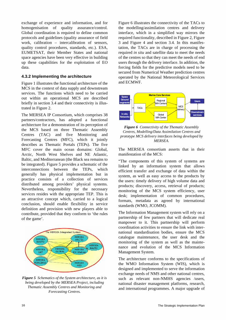
The MERSEA IP Consortium, which comprises 38partners/contractors, has adopted a functionalarchitecture for a demonstration of its perception ofthe MCS based on three Thematic AssemblyCentres (TAC) and five Monitoring andForecasting Centres (MFC), which it jointlydescribes as Thematic Portals (TEPs). The fiveMFC cover the main ocean domains: Global,Arctic, North West Shelves and NE Atlantic,Baltic, and Mediterranean (the Black sea remains tobe integrated). Figure 5 provides a schematic of theinterconnections between the TEPs, whichgenerally has physical implementation but inpractice consists of a collection of servicesdistributed among providers’ physical systems.Nevertheless, responsibility for the necessaryservices resides with the appropriate TEP. This isan attractive concept which, carried to a logicalconclusion, should enable flexibility in servicedefinition and provision with new players able tocontribute, provided that they conform to ‘the rulesof the game’.
Figure 5 Schematics of the System architecture, as it is being developed by the MERSEA Project, including
Thematic Assembly Centres and Monitoring and Forecasting Centres.
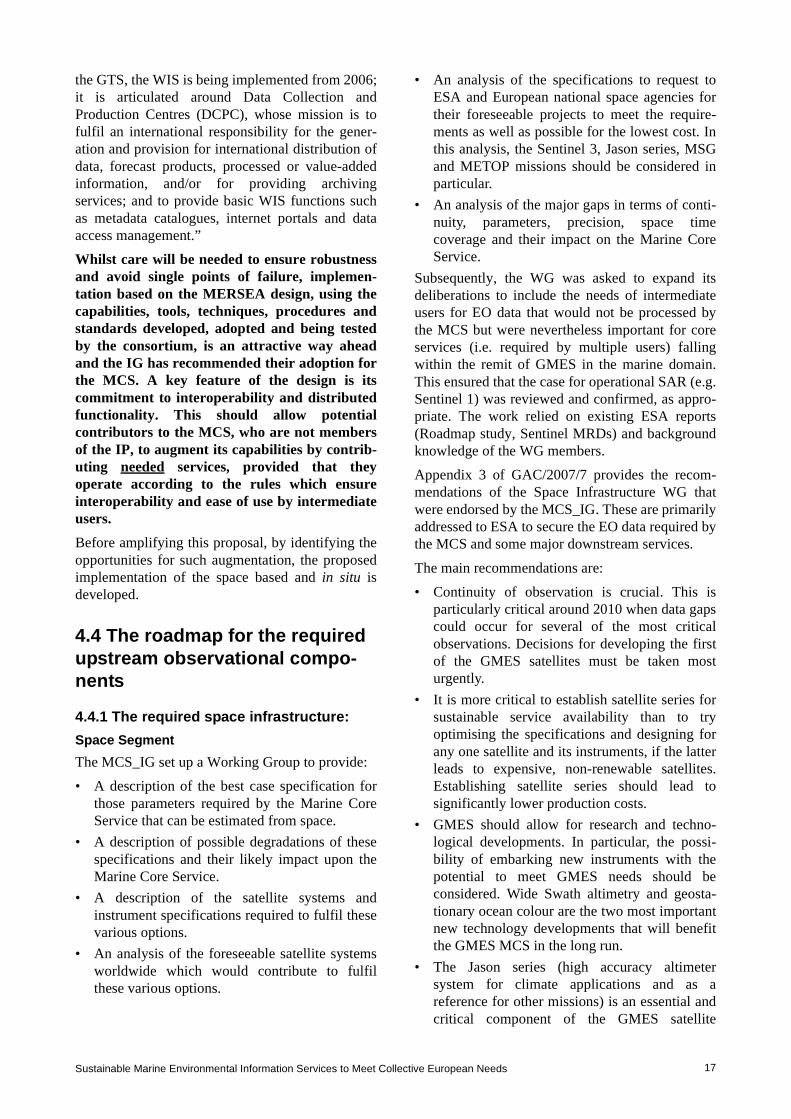
Figure 6 illustrates the connectivity of the TACs tothe modelling/assimilation centres and deliveryinterface, which in a simplified way mirrors therequired functionality, described in Figure 2, Figure3 and Figure 4 and section 3.4. In this manifes-tation, the TACs are in charge of processing therequired in situ and satellite data to meet the needsof the centres so that they can meet the needs of endusers through the delivery interface. In addition, theforcing fields for the predictive models need to besecured from Numerical Weather prediction centresoperated by the National Meteorological Servicesand ECMWF.
Figure 6 Connectivity of the Thematic Assembly Centres, Modelling/Data Assimilation Centres and
prototype MCS delivery interfaces being developed by MERSEA.
The MERSEA consortium asserts that in theirmanifestation of the MCS:
“The components of this system of systems arelinked by an information system that allowsefficient transfer and exchange of data within thesystem, as well as easy access to the products bythe users: timely delivery of high volume data andproducts; discovery, access, retrieval of products;monitoring of the MCS system efficiency, userdesk; implementation of common procedures,formats, metadata as agreed by internationalstandards (WMO, JCOMM).
The Information Management system will rely on apartnership of few partners that will dedicate realmanpower to it. This partnership will performcoordination activities to ensure the link with inter-national standardisation bodies, ensure the MCScatalogue maintenance, the user desk and themonitoring of the system as well as the mainte-nance and evolution of the MCS InformationManagement System.
The architecture conforms to the specifications ofthe WMO Information System (WIS), which isdesigned and implemented to serve the informationexchange needs of NMS and other national centres,such as relevant non-NMHS agencies /users,national disaster management platforms, research,and international programmes. A major upgrade of
Marine Core ServicesSpace
Ground
segmentsRegional
M/A Centers
Downstream
servicesGlobal
M/A Center
TACsMCS
delivery
In situ
Networks
Users
Sustainable Marine Environmental Information Services to Meet Collective European Needs 17
the GTS, the WIS is being implemented from 2006;it is articulated around Data Collection andProduction Centres (DCPC), whose mission is tofulfil an international responsibility for the gener-ation and provision for international distribution ofdata, forecast products, processed or value-addedinformation, and/or for providing archivingservices; and to provide basic WIS functions suchas metadata catalogues, internet portals and dataaccess management.”
Whilst care will be needed to ensure robustnessand avoid single points of failure, implemen-tation based on the MERSEA design, using thecapabilities, tools, techniques, procedures andstandards developed, adopted and being testedby the consortium, is an attractive way aheadand the IG has recommended their adoption forthe MCS. A key feature of the design is itscommitment to interoperability and distributedfunctionality. This should allow potentialcontributors to the MCS, who are not membersof the IP, to augment its capabilities by contrib-uting needed services, provided that theyoperate according to the rules which ensureinteroperability and ease of use by intermediateusers.
Before amplifying this proposal, by identifying theopportunities for such augmentation, the proposedimplementation of the space based and in situ isdeveloped.
4.4 The roadmap for the required upstream observational compo-nents
4.4.1 The required space infrastructure:Space SegmentThe MCS_IG set up a Working Group to provide:
• A description of the best case specification forthose parameters required by the Marine CoreService that can be estimated from space.
• A description of possible degradations of thesespecifications and their likely impact upon theMarine Core Service.
• A description of the satellite systems andinstrument specifications required to fulfil thesevarious options.
• An analysis of the foreseeable satellite systemsworldwide which would contribute to fulfilthese various options.
• An analysis of the specifications to request toESA and European national space agencies fortheir foreseeable projects to meet the require-ments as well as possible for the lowest cost. Inthis analysis, the Sentinel 3, Jason series, MSGand METOP missions should be considered inparticular.
• An analysis of the major gaps in terms of conti-nuity, parameters, precision, space timecoverage and their impact on the Marine CoreService.
Subsequently, the WG was asked to expand itsdeliberations to include the needs of intermediateusers for EO data that would not be processed bythe MCS but were nevertheless important for coreservices (i.e. required by multiple users) fallingwithin the remit of GMES in the marine domain.This ensured that the case for operational SAR (e.g.Sentinel 1) was reviewed and confirmed, as appro-priate. The work relied on existing ESA reports(Roadmap study, Sentinel MRDs) and backgroundknowledge of the WG members.
Appendix 3 of GAC/2007/7 provides the recom-mendations of the Space Infrastructure WG thatwere endorsed by the MCS_IG. These are primarilyaddressed to ESA to secure the EO data required bythe MCS and some major downstream services.
The main recommendations are:
• Continuity of observation is crucial. This isparticularly critical around 2010 when data gapscould occur for several of the most criticalobservations. Decisions for developing the firstof the GMES satellites must be taken mosturgently.
• It is more critical to establish satellite series forsustainable service availability than to tryoptimising the specifications and designing forany one satellite and its instruments, if the latterleads to expensive, non-renewable satellites.Establishing satellite series should lead tosignificantly lower production costs.
• GMES should allow for research and techno-logical developments. In particular, the possi-bility of embarking new instruments with thepotential to meet GMES needs should beconsidered. Wide Swath altimetry and geosta-tionary ocean colour are the two most importantnew technology developments that will benefitthe GMES MCS in the long run.
• The Jason series (high accuracy altimetersystem for climate applications and as areference for other missions) is an essential andcritical component of the GMES satellite
The Strategic Implementation Plan18
programme for MCS. Planning of Jason-3 mustbe a priority for GMES.
• The MCS requires a high-resolution altimetersystem with at least three altimeters in additionto the Jason series. Sentinel-3 should include aconstellation of two satellites, flying simultane-ously, providing adequate coverage and opera-tional robustness. Instrumentation costs for S3should be reduced as much as possible to allowfor a two-satellite system.
• Compared to the present design of S3 instru-mentation, the priority for Sea Surface Temper-ature is for high accuracy dual viewmeasurements. The large swath requirement hasa much lower priority, in particular (but notonly) if S3 is a two satellite system. As far asOcean Colour is concerned, a sensor having asimilar spectral resolution to MERIS is essentialto meet the important shelf and coastal oceanwater quality measurement requirements. Theuse of a SeaWiFS type of instrument (reducednumber of channels) would serve only theminimum operational requirements for the openocean.
• SAR data (Sentinel 1) are required, in particular,for downstream oil spill detection and sea icemonitoring. These are European core data in thesense that they have multiple uses and arerequired for downstream services in the marinedomain. The requirement is for at least one andpreferably two SAR missions in addition to theother non-European missions (e.g.RADARSAT)
• Access to other European and non-European(e.g. NPOESS, RADARSAT) satellite data inreal-time is fundamental for the MCS.
The current offer from ESA and EUMETSAT isdescribed in section 4.3.3 of GAC/2007/7, but inoutline:
• The WG recommendations have been actedupon by ESA in the design of Sentinels 1 and 3.
• ESA has a mandate, as part of the GMESprogramme approved by the ESA MemberStates, to manage and coordinate the overallGMES space infrastructure including the accessto all satellite data required by GMES, startingin 2008 and develop GMES-specific spaceinfrastructure.
• At present, continuity of the Jason series ofsatellites is not secure but there are proposalsunder consideration by the EUMETSATgoverning bodies.
• EUMETSAT has signalled its interest in actingas a data provider for the MCS through theprovision of a consolidated real-time satellitedata stream (including EUMETSAT, NOAA andother 3rd party data), with the exception of theSAR data.
• A consolidated ESA/EUMETSAT approachregarding the provision of EO data to the MCSis expected to be available during 2007.
The funding of the space component will comefrom both the ESA GMES programme and the FP7Space Theme work programme, in agreement withthe EC.
Part of the EC’s FP7 funding (130 M€ total for2007–2013) is planned to be made available to ESAin order to organise the coordinated and harmo-nised access to EO data for GMES services. In thisframework, ESA is setting up agreements with EOmission data providers in Europe and worldwide. Ground SegmentThe Ground Segment of the Space Infrastructurerequired for the MCS and downstream servicesconsists of two stages: (i) the basic processing thatgenerates ocean data products from each individualsensor; and (ii) the additional processing thatprepares data from multiple sources for operationaltasks such as assimilation into ocean forecastingmodels. The first stage is a space agency task,following well-established EO practices. Previ-ously responsibility for the second stage, if it takesplace at all, has been shared in an ad hoc waybetween the space agencies, major data users andthe EO science community. It is recommended that,for the MCS and intermediate service providers,this stage of additional processing should beperformed by Thematic Assembly Centres (TACs)– see below – as an integral part of the MCS,tailored to the special requirements of operationalusers of particular data products. Implementation ofthese latter functions is described in section 4.5.1.
At the end of the SEPRISE project, detailed groundsegment requirements and solutions remain to beaddressed. But, for Sentinel 3 the main recommen-dation is likely to be that the GMES groundsegment should develop robust interfaces withEUMETSAT Ocean & Sea Ice SAF and with theMCS satellite Thematic Assembly Centres. ForSentinel 1, the ESA rolling archive for ASAR hasalready demonstrated the capability to deliver nearreal-time SAR strips to support both routine Arcticsea ice monitoring and specific operational applica-tions but in future clear guarantees will need to be

Sustainable Marine Environmental Information Services to Meet Collective European Needs 19
provided for data delivery, as is the case forRADARSAT now.
4.4.2 The required in situ infrastructureAppendix 4 of GAC/2007/7 contains the report ofthe in situ infrastructure WG. As in the case of thespace infrastructure, it identifies the candidatetechnologies that are available for a compositeoperational in situ observing system capable ofmeeting the needs of an MCS serving the purposesidentified in section 3.1; essentially they are thosethat are sufficiently tried and tested in such applica-tions. Potentially useful technologies are identifiedfor possible future use too.
Candidate observing systems comprise:
• Drifting Argo Floats for the measurement oftemperature and salinity profiles to ~2000 mand, by tracking them, mean subsurfacecurrents.
• Research vessels which deliver complete suitesof multidisciplinary parameters from the surfaceto the ocean floor. The information collected isof high accuracy, quite necessary for variousvalidation tasks, but very sparse, with inter-mittent spatial coverage, at very high cost ofoperations and with very limited real-time trans-mission. Such vessels should be encouraged tocollect and report routine surface observationswhenever they are underway.
• XBTs launched by research vessels and ships ofopportunity underway for the measurement oftemperature and salinity profiles to ~450–750 m depth.
• Surface Moorings capable of measuringsubsurface temperature and salinity profiles, inparticular those that measure continuously overlong periods of time. Currents are oftenmonitored and meteorological measurementsare usually made too. Biofouling restricts therange of measurements that can be made fromlong deployments in the photic zone but surfacesalinity and biogeochemical measurements areattempted.
• FerryBox and other regional ship-of-opportunitymeasurement programmes for surface transectswhich may include temperature, salinity,turbidity, chlorophyll, nutrient, oxygen, pH andalgal types.
• The Continuous Plankton Recorder (CPR)operated by the Sir Alister Hardy Foundation forOcean Science which is towed from merchantships on their normal sailings in order to
monitor the near-surface plankton of the NorthAtlantic and North Sea on a monthly basis.
• The network of tide gauges which provides longterm reference and validation sea level data.
Priorities for implementing these technologies in acoordinated manner to provide continuity andexpand their utilisation, particularly to achieve nearreal-time data collection, are discussed furtherbelow.
There are several difficulties associated with thedeployment of systems based on these technol-ogies. Almost all are deployed for researchpurposes or as national contributions to ongoingenvironmental assessment programmes committedunder the Regional Conventions. The latter tends tobe concentrated in coastal waters and none deliverreal-time data. Although some attempt has beenmade to coordinate deployments for individualresearch programmes, there is no mechanism atpresent to coordinate efforts to produce what mightbe described as a designed, composite network. TheODON project, listed in section 4.2.3, developedtechniques for this but they are not known to havebeen used since the end of the project.
In order to make progress it does seem that twospecific actions are needed. Firstly, where theimpact of the data is either global or pan-European it would be appropriate for aninvestment to be made by the EC on behalf ofMember States or by the Member States actingtogether. A case of this kind has been put forinvestment in the Argo technology within theEuropean Roadmap for Research Infrastructures. Itshould be taken up. The impact of the CPR(measured by the maturity of the technology, thelength and extent of the existing record anduniqueness and importance of the data whichresult) is a further candidate for such coordinatedinvestment.
Secondly, there is a need and opportunity withinthe context of GMES, supported jointly by theCommission, ESA and Member States, forintegration and coordination of in situmonitoring efforts. On the regional scale, theEuroGOOS Regional Task Teams or Opera-tional Oceanographic Systems/Networks (wherethey have been formed) would be ideally placedto take this on, perhaps coordinated overall bythe EEA11. In due course a EUMETNET-likearrangement might be put in place for this purpose.There is a need for a relatively small investment inefforts to identify where such actions would bearmost fruit, and it is hoped that this can be found

The Strategic Implementation Plan20
within the GMES Space Component of FP7. On theglobal scale the Joint WMO-IOC TechnicalCommission for Oceanography and MarineMeteorology (JCOMM) provides an appropriatemechanism at an intergovernmental level forplanning and coordinating the acquisition,exchange and management of marine observations,although it would be helpful if a mechanism fordeveloping a common EU position on this could beagreed, particularly if EU funding is provided forspecific components of the global observingnetwork, such as the Argo float technology.
At this stage the following priorities are suggestedto guide these two actions:
• Sustain the Argo network: ~800 new floats to bedeployed each year to replace the ones that fail.The European ‘fair share’ of this is about 250units.
• Encourage the deployment of and collection ofnear real-time data from automated observingsystems such as XBTs, Ferrybox and CPR onresearch vessels and ships-of-opportunity.
• Encourage Member States to continue to makemarine observations that are useful for nationalpurposes and, if shared in near real-time, wouldhelp sustain the MCS and downstream services.Specific examples include data from the tidegauge network and moorings.
• Investment is needed in carefully chosen well-equipped observatories at locations where datawould provide valuable constraints on models.
4.5 Implementation of the MCS
4.5.1 Data collection, assembly and quality control within the MCSSection 3.4 and Figure 2 outline the data collectionand processing functions which are needed by theMCS. Figure 6 illustrates how the TACs areconceived within the MERSEA IP as the gatewaysthrough which observational data reach the rest ofthe MCS activities. Because of the diversity ofdifferent sources from which observational data areacquired, including different sensor types thatsample the same ocean product in different ways,
the TACs are needed to harmonise the data to facil-itate their ingestion and assimilation into oceanforecasting models, and where appropriate to blendthe data into analysis products for application bydownstream users.
The TACs perform the following generic functions:
• Collection of level 1/2 data EO data from theground segment of the space segment andrelevant global and regional in situ networks.
• Real-time additional processing of level 2 dataproducts received from European sensors, ifnecessary, to generate a common data formatand product standard, facilitating an interop-erable, harmonised data distribution systemwithin the MCS.
• Near real-time level 3/4 processing activities,generating analysis products that correspond tothe best estimate of an ocean property, blendingdata from various sources.
• Providing ready access to all data products usinga spectrum of delivery methods to users,including real-time high volume data flow to theM/A centres and other operational users,solutions tailored to individual downstreamservices and web access for general publicusers.
• Delayed mode level 3/4 processing activities,including the updating of ancillary data as theybecome available within a few days of acqui-sition, as well as later reanalyses to producehigher quality products for climate monitoring.
• Quality control, validation and error characteri-sation, applying to the products and forecastsproduced within the TAC. This activity needs tobe underpinned by in situ observations. Thisdoes not remove the requirement for the spaceagencies to validate their basic level 2 products.
• Interfacing with international activities for thesame type of data, and with TACs for other datatypes including in situ data for validation.
• Providing effective feedback on data productsbetween users and the observing systems.
For processing EO data:A number of collaborative multi-missionprocessing and dissemination facilities are alreadyin place within Europe which perform the whole orpart of the TAC functions for Altimetry, SeaSurface Temperature, Ocean Colour, Sea Ice andWinds, and which are already interfaced withdifferent satellite ground segments. These representa point of departure at least for the implementationof the MCS. They include:
11. According to its Mandate (especially Art 3, CouncilRegulation (EEC) No 1210/90 of 7 May 1990) EEA plays akey role in the European in situ monitoring community. InJuly 2004 EEA outlined its view of the objectives and role ofin situ monitoring within GMES (GAC (2004)6), followed bya first progress report on the development of the GMES insitu monitoring component in November 2004(GAC(2004)21.

Sustainable Marine Environmental Information Services to Meet Collective European Needs 21
• The CNES/CLS SSALTO/DUACS processingactivity for sea surface topography.
• The ESA DUE project Medspiration andMERSEA, serving as the European componentof the international GHRSST Project, delivers aset of harmonised SST products that are nowbeing used operationally by a steadily growinguser base. It has an upstream interface withEUMETSAT’s Ocean & Sea Ice SAF anddownstream interfaces with operational users.
• Ocean Colour data have been provided forMERSEA by a consortium led by EC/JRC.Merged products are also being developed bythe ESA DUE GlobColour project. Someconsolidation will be appropriate.
• CERSAT delivers Sea Surface Winds and fluxes(interfaces with Ocean & Sea Ice SAF).
• EUMETSAT’s Ocean & Sea Ice SAF providesSea Ice data from passive radiometry on anoperational basis.
It is evident that each of these data types has itsown distinct user requirements and its processingsystem has achieved a different level of maturity.Thus although the TACs will serve the samegeneric functions (see the left hand side of Figure2), it is important to treat each ocean data producttype individually. Further consideration isneeded to define the comprehensive require-ments for fulfilling the TAC functions for eachtype of ocean data product. It also remains to bedecided whether Regional TACs are required orwhether regional data can be provided satisfac-torily by a global TAC.
In the future, it may be appropriate to considerdeveloping a TAC for the processing of syntheticaperture radar (SAR) in which all SAR data overEuropean waters are analysed to extract their infor-mation content concerning surface winds, wavespectra, oil pollution, ship detection, sea ice andother ocean phenomena. This could evolve fromboth geographically-limited sea ice analysis, andthe service currently being developed by EMSA forroutine monitoring of European SAR data to detectoil spills at sea. Oil spill detection and characteri-sation based on SAR data is being carried out by acombination of KSAT (Norway), Boost Technol-ogies (France) and Telespazio (Italy) within theMarCoast project.
Regarding services tailored to the Arctic (seesection 4.6.2) several new regular sea ice productsneed to be produced from wide swath SAR datasuch as:
1. Sea ice deformation including drift, conver-gence, divergence and shear zones
2. Presence of leads and polynyas3. Identification of fast ice zones4. Deformed versus undeformed ice and ice-ocean
discrimination using polarisation ratio. Algorithms to produce these products already exist,and are being further developed by ESA’s GlobICEproject. In due course, they should be implementedfor operational use as part of the TAC function forsea ice.
Depending on the success of the ESA SMOSmission in measuring ocean salinity, there may be aneed to develop a TAC for Sea Surface Salinityfrom 2010.For processing in situ data:• The Coriolis centre in France is providing the
necessary functionality for global and someregional data within MERSEA.
• SeaDataNet, which aims to develop an efficient,distributed Pan-European Marine DataManagement Infrastructure for managing thelarge and diverse marine data sets12. Theobjective is to network the existing professionaldata centres of 35 countries, active in datacollection, and provide integrated databases ofstandardised quality, on-line.
• The TAC functions and assignments to meetregional requirements remain to be determined.The tasks are being carried out to some extentby the ROOSes (NOOS, BOOS, MOON) andexchange of the resulting data sets has beendemonstrated very successfully in the SEPRISEproject13. This has shown what is possible butalso demonstrates the acute differences that stillexist in the availability of data and productsbased upon them across Europe and the lack ofintegration of data sets across national bound-aries.
For atmospheric forcing data:ECMWF and several NMSs are capable of carryingout this function and do provide the required infor-mation routinely within MERSEA. Where coupledocean-atmosphere models are being run opera-tionally, two way coupling is possible.
12. www.seadatanet.org/ 13. SEPRISE (2007): European Capacity in Operational
Oceanography and the SEPRISE Demonstration, Deliv-erable D2 and D3

The Strategic Implementation Plan22
4.5.2 Ocean modelling and data assimi-lationThere are a relatively small number of global andregional ocean models capable of assimilating dataand being run operationally in Europe and whichcould contribute to the MCS. The MERSEA IPModelling TEPs are highlighted. Candidatesknown to be available are:
a) Global models, at various resolutions:- PSY3V1 operated by Mercator- FOAM operated by UK Met Office
b) For the Arctic / North Atlantic Oceans:- TOPAZ operated by NERSC/Met Norway
c) For the Baltic:- BALECO operated by FIMR- HIROMB operated by SMHI- BSHCmod operated by DMI +
both of the latter require boundary conditionsfrom the North West Shelf Area andtherefore provide output in this domain too.
d) For the North West Shelf / North East Atlantic:- POLCOMS and FOAM respectively
operated by the UK Met Office- PSY2V2 operated by Mercator
e) For the Mediterranean:- The Mediterranean Forecasting System
operated by INGV
In addition, there are many examples of smallerdomain models being operated for local, nationalpurposes taking boundary conditions from theabove and delivering specialised products, e.g.surges, ice, oil and S&R drift, eutrophication, etc.
There is substantial model development withinMERSEA to:
• develop a new modelling framework – theNEMO code
• improve multivariate data assimilation methods• increase model resolution• incorporate ecosystem modules• …It is to be expected that this will deliver new, morecapable global and regional ocean models.
Given the substantial investment needed incomputing resources and skilled staff necessaryto operate, maintain and develop them, and theagreement reached between the partners overthe global and regional responsibilities of theindividual centres, it will be wise to base theinitial MCS, at least on the MERSEA assign-ments. However, if there is a possibility ofproviding a choice of model products to thedownstream service providers that optionshould not be precluded, i.e. there should be no‘closed shop’. However, the services provided bythe MCS consist of much more than modelproducts. Any supplier will need to commit tothe supporting services outlined in section 3.4and described in more detail below.
Figure 7 Availability of data from fixed marine sites

Sustainable Marine Environmental Information Services to Meet Collective European Needs 23
4.5.3 Service generation, access, delivery and supportState-of-the-art capabilities are being developed byMERSEA for implementation in 2008. These aimto provide a portal for each domain, whichcomprises:
• A discovery service• A viewing service• A download service, which will need to include
or be supported by the facility for sustained,scheduled delivery of high volume datasets forintermediate users, who are themselves runningcontinuous operations that need such a service.
Product descriptions are to be standardised andavailable in a homogenous catalogue.
The MERSEA consortium is committed to anumber of supporting activities that guarantee alevel of quality in service provision and thatfollow standards to be spelled out in ServiceLevel Agreements. They are all crucial to thesuccess of the MCS and are broadly compatiblewith the desired functional analysis of section3.4. Others who might aspire to contribute to theMCS should expect to provide equivalentservices and commit to the same Service LevelAgreements.
Five service lines are proposed:
a) SL1: production of marine core information anddata
b) SL2: dissemination of marine core productsc) SL3: assessment and expertise on marine
productsd) SL4: ocean analysis tools development and
maintenancee) SL5: training and research coordination.a) SL1 ProductionOperators will need to develop and produce qualitycontrolled fields (analyses and forecasts) describingthe global ocean and European seas, based on spaceand in situ observations data and their assimilationinto appropriate ocean models. This activityincludes different product lines:
• Observation and model products for the statevariables listed in Table 2 for example
• In several modes: nowcasting, forecasting(several days), and re-analysis (up to somedecades)
The latter requires both real-time operational linesand delayed mode data lines.
b) SL2 DisseminationAll operators must provide to users the advertisedinformation on the ocean state, either through theirown production (SL1) or by being a reference
Figure 8 The MERSEA Consortium

The Strategic Implementation Plan24
access point to other production from centres thatare not part of the MCSMO (MCS ManagementOrganisation). This will include the appropriatetools for search and discovery, viewing, anddownloading of products. The download servicewill need to include or be supported by the facilityfor sustained, scheduled delivery of high volumedatasets for intermediate users, who are themselvesrunning continuous operations that need such aservice.
Catalogues and inventories of products must behomogenous, readily accessible, searchable, andupdated regularly.
The dissemination will be subject to the data policyto be agreed upon, but hopefully as set out insection 4.5.5.
The proposed assignment of responsibility for theportals that will carry these tools is that chosen bythe MERSEA consortium and illustrated in Figure8.
Information products accessible through eachportal should relate to the domain in question, meetthe standards described in section 4.5.4 and otherservice qualities set out below, including guidancein their use. The aim will be to give the easiestpossible access to information and, where it exists,choice to the user.
c) SL3 Assessment and expertiseAll production of the MCS must be fully validated,with known accuracy and error estimates. MCSmust provide expertise on the marine core products,to support efficient use of its output or bringdirectly information to interested users. Humanexpertise is added to the production and dissemi-nation functions, to proceed from data to infor-mation for the benefit of users.
Access to information from forecasts produced bydifferent Centres is a powerful tool for assessmentof their reliability and accuracy; it is desirable thatthe MFC should enable such multi-model interpre-tation and presentation.
For instance, regular bulletins and assessmentreports can be published to explain the mainfeatures of some of the products; expert analysiscan give a thematic interpretation of the marinecore products; specific post-processing, on demand,to extract subsets of products, or to elaboratesummary indicators based on MCS data (selectionand transformation).
The expertise service could include the elaborationof calculated fields derived from the state variables(e.g. mixed layer depth, upwelling indices, trans-
ports, heat content), anomalies, climatologies orstatistics.
In cooperation with expert topic centres, the serviceshould contribute to reference reports on the oceanstate (Regional Conventions, EEA, ICES, etc.), orsimple and systematic studies of observingnetworks (Argo, altimetry, etc.), or for operationaluser agencies.
d) SL4 Ocean analysis tools, development andmaintenance
The MCS should develop and maintain, for thebenefit of the European community of intermediateusers and other operators, a suite of reference codesand frequently-needed tools required to use MCSproducts and to develop downstream activities andservices. It is mandatory that the codes bemaintained at the forefront of the state-of-the-artand be fully validated; with error estimates. Thisrequires expertise in the transfer of research resultsinto the operational suites.
The capabilities required to sustain and improve theMCS also need to be developed, validated,upgraded, maintained and disseminated atEuropean level. These include tools such as theNEMO Ocean modelling code; data assimilationtools; toolboxes for nesting, downscaling, andinterfacing models; validation algorithms (metrics,observations/model, …); data handling codes;visualisation; diagnostics routines.
e) SL5 Training, research, and outreach coordi-nation
The MCS should actively develop and promotescientific and educational programmes for thebenefit of operational oceanography as a contri-bution to the development of European capacity inthe subject.
An active research community must be entrained indisciplines and fields of research of relevance tooperational oceanography. MCS can play a leadingrole in research networking and connection withresearch teams in Europe, and beyond; it canpromote coordination of research initiatives linkedto operational oceanography, and it must contributeto capacity building and outreach.
Training can be provided through summer schools,conferences, or students courses on operationaloceanography; traineeships, PhD and post-docprogrammes can be associated with the MCSCentres.
These research programmes will be of two types:
• One must be closely coupled to the MCS toensure that projects are driven, in part at least by

Sustainable Marine Environmental Information Services to Meet Collective European Needs 25
the specific needs of the operators, and remainaware of emerging research results. There is nodoubt that progress in ocean modelling,monitoring and prediction will be achieved onlyif such programmes are effectively pursued,coordinated and funded. Experience fromother successful providers of services of thekind to be offered by the MCS suggests that afraction of the turnover of the endeavour (ofthe order of 5–10%) should be set aside forsuch closely coupled research; such examplesinclude the major NMSs and ECMWF.
• The other will be driven by the need to resolvepriority issues in the relevant sciences (asidentified by the ESF Marine Board forexample) and to explore new technologies formonitoring the marine environment, using EOand in situ methods. These are likely to befunded within national research programmes,the Framework Programmes, or by ESA throughtheir Explorer missions and industry.
GMES and GEOSS share a range of strategic andtechnical issues and offer opportunities for interac-tions (e.g. space and non-space observationplatforms, data exchanges and network connec-tions, tasking and integration of observations, adhoc campaigns). At the European level, the twoinitiatives are closely related in that:
• As it develops itself, GMES will become, withthe data it can generate, a main European contri-bution to the GEOSS
• GMES will benefit from the observationscollected and exchanged in the frame of theinternational GEOSS activities.
European GEO consultation meetings are regularlyorganised and chaired by the Research DG tocoordinate the position of all European GEOmembers supported by the Framework Programmein order to ensure a strong European voice andinfluence on decision-making at the GEO plenarymeetings. This includes ensuring appropriateEuropean representation in the GEO Executivecommittee and providing the European share offunding of the GEO secretariat out of the EUFramework Programme.
It will be important that the MCS plays its partin ensuring that this ‘European voice’ is well-informed by the benefits which the marinesector can gain from and contribute to theGEOSS.
4.5.4 StandardsOne of the objectives of the MCS is to provideconsistent quality and standard of service. This putsstrong requirements in terms of robustness of theproducts and delivery channels; timeliness ofproduction and delivery; fitness for purpose againstspecific requirements; stability and homogeneity ofre-analyses; traceability and quality performance.Users of MCS serviced must not need bespokeinterfaces to access and use its products. GMES asa whole has to deliver interoperability betweenits components, so conformity to the expectedINSPIRE Directive will be mandatory.
In order to achieve this goal, the MCS delivery ofdata and data products should conform to Interna-tional Open standards as will be promoted withinthe INSPIRE program. In particular the viewingservices should conform to Open GIS standards,providing Web Feature Services (WFS) for in situdata and Web Map Services (WMS) to allowviewing of geospatial gridded data. These can belive services working directly upon the data reposi-tories. These viewing services should be available(with appropriate security) at all MCS servicecentres to allow the overlaying within a web portalof MCS geospatial view products with each otherand with third party GIS based products without theexchange of the data themselves. For data exchangethe MCS should eventually conform to the WebCoverage Service (WCS) standards althoughinterim methods such as secure ftp or OPeNDAPare envisaged.
The MCS should provide sufficient under-pinning support for the development of appro-priate viewing services to allow information tobe viewed within any downstream GIS-basedservices conforming to the Open Standards. Thiscould include commissioning of specific viewingservices appropriate to the marine domain. As aFast Track Service the MCS should be resourced totake the lead in this area which will
1. Greatly increase the visibility and availability ofMCS products in a highly professional way
2. Provide easy-to-use calibration/validationservices for use within the consortium, e.g. byoverlaying MCS products with satellite images
3. Provide a lead for future European geospatialservices.
The MCS should also seek to develop partnershipswith other geospatial information services aroundEurope. A directory of all Geospatial informationservices in OGC format should be available with aportal to combine and overlay them. This would go
The Strategic Implementation Plan26
a long way towards providing an integrated view ofthe European Environment as outlined in theINSPIRE initiative.
Standards to be applied will be specified or refer-enced in Service Level Agreements (SLA), and/orService Charter for overall MCS consistency,which must cover the points above, as well asrequirements to maintain the system at state of theart; to use all available information; to performmulti-model estimation and forecasts; to engage inresearch and development (see SL4 and SL5above); specification of the areas of serviceprovision; the rules for access to infrastructure;consideration of the operational status, security,system monitoring, etc.
4.5.5 Funding and Data PolicyAt present there are no reliable estimates of the fullcosts of a reliable, efficient MCS or of the upstreamand downstream capabilities that are required todeliver value from it. Such estimates are requiredduring the next year or so as experience growsduring the FP7 funded demonstration phase; notleast to ensure that the case for long-term funding isrobust.
In the interim, it is assumed that, because theservices being delivered by the MCS are publicgoods they will be co-funded by the EU andMember States, not at the point of delivery bycharges levied on intermediate users. This is themodel adopted for the development and demon-stration phase of the GMES Fast Track MCSfunded through the FP7 Space Programme.Continued adoption of this model has to beverified, probably within the context of theproposed INSPIRE initiative. The scale of theexpenditure required suggests that some form ofcost sharing by Member States and the EU wouldbe agreed to deliver the service defined ultimatelyin the SLA(s) between the GMES ManagementAuthority and the MCSMO or operators. In effectthis is the current funding model of the space infra-structure with ESA too. Presumably some MemberState contributions would be in-kind, in the form ofnational support for the operators and datacollection/provision (both EO and in situ).
On this basis, it is further assumed thatupstream data and MCS data, products andservices made available to intermediate userswill be free of charge, except for the cost ofdelivery, if they are used exclusively for GMESpurposes.
It is expected that intermediate users will befinanced through user charges in effect for thevalue that they add to the information and servicesthat they obtain from the MCS and other upstreamservice providers. Some ancillary data may fallwithin the scope of the INSPIRE Directive whileothers will be available on terms specified by theirsuppliers.
There is no doubt that some EU level support willbe desirable for intermediate service providersduring the MCS demonstration phase at least. It isunderstood that this is planned within FP7. Atpresent such support is being provided by the ESAGSEs, in particular MarCoast and Polar View, andthrough the data purchase activities of EMSA. TheESA-managed, EC-funded data-buy planned withinFP7 will be crucial in this regard too.
4.5.6 Governance and related issuesThere are a number of issues to be resolved thattranscend the strictly scientific and technicalmatters which guide the infrastructure design andimplementation. Some considerations, particularlythose of top-down governance of the implemen-tation of the GMES, will be settled at a politicallevel, presumably in the GMES Bureau and GMESAdvisory Council. However it is reasonable tosuppose that the structure and day-to-daygovernance of the MCS can and will be designedaccording to some general principles.
a) Accountability and Management structuresIt is envisaged that the MCS will be distributed andcomprise a number (of order 10 as discussed insection 3.3) of operators that will produce and offerproducts and services, as characterised in theAppendix and section 4.5.3, to intermediate users.Some such operators are likely to be consortia.Other operators will be responsible for theThematic Assembly Centres described above.Other actors will exist in the form of external dataproviders, such as ESA and EUMETSAT for EarthObservations and agencies in Member States for insitu data, acting singly or as the consortia whichcomprise the Operational Ocean Systems/Networksof EuroGOOS. If the EEA assumes greater respon-sibility for oversight of in situ data collection forGMES generally, it may act in loco parentis forsuch agencies and consortia.
Two broad classes of solution can be envisaged tomanage the interfaces between these providers andthe expected GMES Management Authoritydescribed in GAC(2006)6.
Sustainable Marine Environmental Information Services to Meet Collective European Needs 27
i) The GMES Management Authority itself couldmanage all of the interfaces with all of theactors. Logically it would need to do so for allthe Fast Tracks and their follow-ons, whichwould be a complex business requiring adetailed knowledge of very diverse technicaloperations.
ii) Alternatively and more realistically, in order toprovide the necessary degree of integration andcoordination of policies and decisions made incommon by the MCS operators, an MCSManagement Organisation (MCSMO) could beformed. This would need to have a legal person-ality. Looking inwards, it would be responsiblefor ensuring that the operators as outline abovedelivered their offered services according toagreed Service Level Agreements (SLAs). Theexternal data providers (ESA, EUMETSAT, insitu consortia, EEA, etc.) would probably haveSLAs with the GMES Management Authority,but the alternative of making them with theMCSMO is for consideration. Lookingoutwards, such an Authority would represent theMCS in its interaction with the GMESManagement Authority with respect to the‘General Management’ Function described inGAC(2006)6. An MCSMO would be better ableto exercise the Technical Management functiondescribed in that document than would aGMES-wide Authority, simply because the userdemand, technical solutions, actualperformance, research needs and qualificationprocesses are likely to be specific to the marinedomain at least. Of course in this model theMCSMO would be accountable to the GMESAuthority for all the functions for which it wasresponsible.
In the very short term, i.e. in responding to opportu-nities to demonstrate and develop the MCS withinFP7, such a Management Organisation might becreated and operated by a lead partner and comprisean executive composed of representatives of aconsortium of operators. However, in the longerterm, there would be some merit in creating aseparate entity with its own legal identity. TheEuropean Economic Interest Group (EEIG) hassome characteristics which would make it anattractive company structure.
The EEIG, i.e. European Economic InterestGrouping is a company structure which can beregistered in all European Union Member Statesaccording to EC Law (Regulation (EEC) 2137/85).The EEIG offers the possibility of cross-border co-operation and collaboration within Europe
especially to small and middle-sized enterprises ofevery legal category including associations andlocal authorities. A precondition is however that atleast two of the enterprises or other bodies of thegrouping are located in at least two different EUMember States; enterprises from Member States ofthe European Economic Area can also take part. Todate approximately 1200 EEIG have been regis-tered in the EU with altogether about ten thousandmembers.
As a result of the growing demands on companieswithin the field of cross-border transactions, theEEIG is an attractive alternative for co-operation invarious economical fields; examples are the estab-lishment of a purchasing and marketing associ-ation, joint research and development or co-operation in fields of personnel and training. Inaddition an EEIG may have significant tax advan-tages (an EEIG is not submitted to corporatetaxation etc.).
These include the following:
• It is a legal framework which aims to developand facilitate the collaboration between entre-preneurs and can represent a profit centre for itsmembers of its own
• It is a very flexible and unbureaucratic legalinstrument, whose rules can be decided by themembers in observance of a few guidelinesfixed in the European regulation
• A grouping can be founded with or withoutassets, investment or know-how transfer
• A grouping can be established by subjects witha different legal status: self-employed persons,private limited company, chambers ofcommerce, etc.
• The members of a grouping go on carrying outtheir own activities autonomously. Theymaintain the activities they ran before andbesides obtain new business opportunities
• A grouping can guarantee a high-level liability:members have unlimited and several liability forits debts
• Profits and losses resulting from its activities aretaxable only in the hands of the members;profits must be divided up among the members,if not reinvested
• A grouping pays neither company taxes nortaxes on earnings
• A grouping can run its own business and canhave a trade mark
• The official address of a grouping can be easilytransferred within the Community. Other legal

The Strategic Implementation Plan28
instruments require a previous winding up of theenterprise, which involves costs, activities andloss of corporate image
• Due to the European regulation no. 2137/85constituting the legal basis of EEIG and, beingdrafted in each European official language,there is no discrimination because of the use of aforeign language.
b) Interactions with intermediate usersDay to day interactions between product andservice providers and their users should beconducted directly. Proposals for cataloguing andsearching for data, products and services are madein the Strategic Implementation Plan. Howeverthere will be a need for intermediate users tointeract with the operators and MCSMO (orGMES Management Authority as appropriate,depending on the adopted management model)to determine, at a more strategic level, the scopeand characteristics of services to be offered, anychanges to them and agree priorities and anassociated R&D programme. Some form ofMCS Commissioning Forum, meeting at leastannually, could provide a suitable body for this.It seems likely that there will be a wide range ofintermediate users. Some means of brigadingcommon interests will be helpful and probablynecessary, perhaps through involvement of associa-tions in the Forum, rather than individual organisa-tions.
c) Criteria for selecting operators and modifi-cation of the partnership
The services will be provided by operators (i.e.institutes, agencies, companies, or consortia) thatmanage and operate functional centres. Theyshould be selected on the basis of their ability tofulfil the requirements of a legally binding contract,their access to the required resources, theirexpertise (scientific and technical), their opera-tional status, track record and previousperformance, commitment to work with the inter-faces, and cost-effectiveness. Regional knowledgeand ownership will clearly be important, as well assound repartition of the work between MemberStates.
The composition of the MCS should be reviewedperiodically to allow for modifications of thepartnership (inclusion of new members orseverance). Several elements could be consideredin such reviews, e.g. the (duly weighted) nationalresources committed to the system, the relativeperformance and strengths of potential operators,national policies, needs for new services, and their
ability to provide fully operational and sustainableservices.
A level of competition in some aspects of theprocess chain will be appropriate to create incen-tives to innovate and improve performance. For thispurpose there will be a need to encourage ameasure of functional duplication. However, thiswill need to be balanced against the imperative tocreate critical mass in a relatively few centres andthe difficulty of duplicating major investments.
Although the major modelling centres that arelikely to form the MCS and most of the currentlycapable thematic data assembly centres are publicorganisations – because it is they who have madethe necessary investments – there is every reason tosuppose that the capabilities required by them andthe other up and downstream services will besupplied by the private sector. Some are likely to beprovided and operated under contract by the privatesector, particularly outside the modelling andspecialist data processing centres. Conflicts of interestPotential MCS operators have their owndownstream service activities and will wish to usethe MCS data and products in the latter. Thisincludes both public and private entities. Thispossibility raises issues of equity, particularly whenthey are in competition with other intermediateusers/service providers who are not part of theMCS.
A priori it seems possible to address this question inthe frame of the SLAs and the MCS and GMESgovernance. The SLAs will clearly identify thetasks to be carried out in the MCS and the resourcesavailable for this purpose. The MCS and GMESgovernances will need to clarify the decisionmaking mechanisms for the MCS activities. Itmight be specified, for example, that teamsinvolved in an MCS operational activity, or in MCSdevelopment activities be clearly identified, andperhaps separated from teams involved indownstream and other services. Of course thisproblem would also be solved if MCS data andproducts were freely available to all engaged inserving GMES purposes, and MCS operators werefully funded.
4.6 Implementation of downstream services A significant effort is still required to elaborateand market downstream services. The datapolicy recommended in section 4.5.5 should

Sustainable Marine Environmental Information Services to Meet Collective European Needs 29
encourage this because the free access to basicdata and MCS products will act as a consid-erable stimulus to the market. There is evidencefor this in the subsidised provision of EO data andsupport for the ESA GSEs, which has encouragedand begun to satisfy downstream use. Furthermore,the well-developed strong private meteorologicalservice sector in the US is sustained by the samedata policy and centralised provision of core(meteorological) services. There is every reason toexpect similar strong innovation and growth inEurope in the marine sector.
Even without that stimulus there are a number ofclear requirements for end user services that canand will be met, in part at least, by the combinationof upstream data services, the MCS and interme-diate service providers offering down-streamservices. These include:
4.6.1 Marine Environmental Strategy Directive and related ConventionsContext14
Europe’s marine environment is faced withincreasing and severe threats. They include
• Climate change• Pollution (including contamination by
dangerous substances, from land-based sources,litter, microbiological, oil spills as a result ofaccidents as well as pollution from shipping andoffshore oil and gas exploration, pollution fromship dismantling, and noise pollution)
• The impacts of commercial fishing• The introduction of non-native (exotic) species
principally through discharge of ships’ ballastwater
• Nutrient enrichment (eutrophication) andassociated algal blooms
• Illegal discharges of radionuclides.Against this background a new Marine Environ-mental Strategy and associated Directive isproposed15. It aims to promote sustainable use ofthe seas and to conserve marine ecosystems, bygiving priority to achieving good environmentalstatus in the Community’s marine environment, tocontinuing the protection and preservation of thatenvironment, and to ensuring that subsequentdeterioration is prevented. For this purposeMember States will be required to prepare MarineStrategies which, while being specific to their own
waters, reflects the overall perspective of the appro-priate Marine Region16. For this purpose they willbe required initially to carry out assessments of thecurrent state of their marine waters. Subsequentlythey will need to establish environmental targetsand monitoring programmes for ongoingassessment, enabling the state of the watersconcerned to be evaluated on a regular basis. Thenprogrammes of measures, which are designed toachieve good environmental status, will need to beestablished and implemented.Service requirementsAssessments will be required to include physicaland chemical features, habitat types, biologicalelements – at several trophic levels – the hydromor-phology and any particular problems such asnutrient inputs and chemical hotspots. Analyses ofpressures and social and economic issues are alsorequired.
Indicators will need to be developed and deter-mined in order to establish where intervention isrequired and whether resulting measures areproving successful in delivering the aims of theStrategy and Directive. Many pressures areepisodic and some arise from crises that createsubstantial pollution events. Services capable ofinforming policing and emergency responses willalso be required.
A recent EEA-led EMMA Workshop17 concludedthat operational oceanography in general, and theMCS in particular, can contribute to marinemonitoring and assessments18 by:
• Providing input to indicator development(especially the State and Impact components ofthe DPSIR assessment framework)
• Identifying temporal variability• Describing spatial variability and dynamics• Contributing to crisis management and episodic
events that affect the state of the marineenvironment.
Providing context for in situ sampling and inter-pretation of their dataAs indicated in the Appendix, the primary contri-bution in the short term will be in the form of
14. COM(2005)504 final15. COM(2005)505 final
16. The Marine Regions are specified as the Baltic, North EastAtlantic and Mediterranean, coinciding with the three of theregions of the MCS.
17. Held at the EEA, Copenhagen, 23–24 October 200618. See for example the series of reports generated by a joint
ICES/EuroGOOS Pilot Project, NORSEPP, which isfocusing on the relationships between fish stocks and thephysical state of the atmosphere and marine environment,e.g. www.ices.dk/marineworld/norsepp.asp

The Strategic Implementation Plan30
physical and a subset of the chemical and biologicalvariables. Furthermore in the longer term it will beimpossible to describe and understand biologicaland chemical characteristics unless the physicalcontext is clear. In particular much effort could bewasted on measures if the major natural marinetransport pathways and structures are not welldescribed, and their role understood and accepted;allowing actions to be taken when and where theywill be effective. Examples of this are to be foundin the identification of regions where oxygendepletion is a natural consequence of a lack ofmixing in shallow water (with associated produc-tivity) rather than a signal of eutrophication.Similarly, phytoplankton growth is known to beconcentrated along a thin boundary (the thermo-cline) at the base of warm summer waters in thenorthern North Sea where the favourable combi-nation occurs of sunlight and a supply of nutrientsfrom below. This has consequences for the devel-opment of Harmful Algal Blooms (HAB) and theformation of a reliable food source for organismsfurther up the food web. Dependencies of thesekinds need to be understood and quantified ifmeasures are to deliver what is expected of them.
Although direct monitoring is limited to the seasurface, EO data provide a valuable source oftimely information about water quality. Inferencesabout the development and extent of algal bloomsand sediment loads can be made from ocean colourobservations. Additional in situ sampling isrequired to identify the potential for and existenceof HAB, nutrient concentrations and the presenceof other pollutants. Managers and communitiesneed forecasting systems that address where aharmful algal bloom is today and where it will be inthe near future. This places a particular emphasison near real-time collection of such in situ data.The use of SAR data in oil spill detection isdescribed in section 4.6.3. Specific product requirements• Reanalyses of EO and in situ observations over
a number of years are required to establish meanphysical and chemical states (includingcurrents) in a GIS format, together with varia-tions about the mean and for identification oftrends
• Indicators and state data contributing toindicators
• Analyses of meteorological and oceanographicconditions, to provide context to measurementcampaigns and during environmental crises,such as those manifest as eutrophication, oilspills and algal blooms
• Forecasts of the evolution of such crises toenable coordinated responses.
Observing system requirementsEO: Continuity of ocean measurements asdescribed in section 4.2.1.
In situ: physical, chemical and phyto- andzooplankton variables to contribute to the aboveproducts using the technologies, also described insection 4.2.1.Relevant current coordinating organisations• EEA and its partners in the European
Environment Information and ObservationNetwork
• The Regional Conventions: HELCOM, OSPAR,Barcelona; UNEP-MAP
• ICES• IOC-SCOR Scientific Steering Committee for
GEOHAB (Global Ecology and Oceanographyof Harmful Algal Blooms).
End-to-end services EO data in the form of measurements of sea surfaceheight and temperature and in situ measurements ofsalinity, temperature and current profiles arerequired for assimilation by MCS models. Oceancolour data provide context and indications of theannual cycle of primary production and abnormal-ities such as algal blooms at the sea surface, whichmay be harmful. In situ measurements of the bio-geochemical and biophysical variables listed inTable 2 provide important contributions for theassessments and to validate the specific productslisted above, which will be created by the MCS.The Regional Conventions, OSPAR andHELCOM, have made a joint statement on theirprospective contributions to the implementation ofthe Marine Environmental Strategy19. This includescommitments to establish systems to minimise anyoverlaps in their individual monitoringprogrammes; to ensure that collecting and reportinginformation on the marine environment can becarried out by single processes; and that theresulting information is then shared between therelevant bodies. OSPAR has adopted a strategy fora Joint Monitoring and Assessment Programme,from which the relevant regional components of theMCS might hope to benefit, through access to data,and to which the MCS can contribute, through theprovision of capable physical and biogeochemicalmodels.
19. First Joint Ministerial Meeting of the HELSINKI and OSPARCOMMISSIONS (JMM) Bremen: 25–26 June 2003, Recordof the Meeting – Annex 6.

Sustainable Marine Environmental Information Services to Meet Collective European Needs 31
The MCS will provide some indicators but interme-diate users participating in the work of the RegionalConventions and within the EEA’s Topic Centresare likely to use the MCS products to generatemore. These products will also be used by interme-diate users carrying out research to construct andvalidate the measures required to deliver goodecological status. Estimates of the transport acrossEEZ and territorial water boundaries will also beprepared to determine the extent to whichpollutants are being exported and imported.
A number of EuroGOOS members and othernational agencies provide water quality services,largely based on ship-borne surveys, augmented byroutine monitoring from moorings and transectscarried out using the FerryBox technology. Somealso make regular use of Ocean colour data toprovide context and indications of abnormalities, asindicated above. The MarCoast GSE currently hassome 30 users, largely amongst national authoritiesresponsible for monitoring and maintaining waterquality, for services based on variables such asChlorophyll-a and suspended matter that areinferred from MERIS and MODIS data. Invariablytemperature and current data are provided too toassist in their interpretation. In future the latter arelikely to be provided by the MCS.
4.6.2 Ice ServicesContext20
The Arctic Climate Impact Assessment report,which has been developed under the ArcticCouncil, shows that the global warming in theArctic is dramatic with many significant conse-quences. There are enormous oil and gas fields,minerals, fisheries and other resources in the Arcticregions that will be increasingly important forEurope. The exploration and exploitation of theresources in these regions are severely hampered byharsh climate and in particular by the presence ofsea ice. Sea traffic in the Baltic Sea is growing (731Mtons in 2003 is expected to grow into 1148 Mtonsby 2020), especially oil transport from Russia viathe new oil terminals in the Gulf of Finland(according to conservative estimates, 200–250Mtons by 2015). Marine operations including trans-portation by ships in the Northern Sea Routebetween Russia and Western Europe is increasingwith associated risk for accidents and damage to theenvironment.
Global climate change with many severe conse-quences is on the political agenda. The Arctic is ofparticular interest because the global warming ispredicted to be the most pronounced in this regionwith many implications for sea transport, resourceexploitation, construction, ecosystems, and theenvironment. The Arctic sea ice is predicted to bereduced by 80% during summer at the end of thiscentury, while during winter the now seasonallyice-covered Barents Sea is expected to be ice-free.This will have a range of important potential bio-geophysical consequences and associated socio-economic impacts. The Arctic environment is veryvulnerable and small disturbances can have a verylong-lasting impact. Environmental policies havedefined a number of regulations with impact on allhuman activities in high latitudes.
National ice services have been providing sea iceinformation for almost a hundred years. Ice chartsand ice forecasts are the most important outputstoday. A list of national ice services and theirproducts with examples can be found at WMO No574: Sea Ice Services in the World (www.jcomm-services.org/modules/documents/documents/WMO_574.pdf).
A joint North American Ice Service (NAIS) hasbeen created between the National Ice Service(USA), Canadian Ice Service (Canada) and Interna-tional Ice Patrol (USA), which in a few years willcombine operations, budgets and manpower undera single system. Compared to Europe this newservice cluster will have a powerful influence in allArctic ice services.
The ESA GSE Polar View offers integratedmonitoring and forecasting services in the PolarRegions using satellite earth observation data tosupport improved decision-making, planning andadaptation to climate change. The intent is todeliver those services that address both the opera-tional and scientific needs of stakeholder groupswho are interested in issues related to sustainableeconomic development, marine safety, and theenvironment. The GSE includes over 30 differentuser groups.
Current products include:
• Global and regional daily maps at mediumresolution (3–6 km) of ice extent and compo-sition based on the US Advanced MicrowaveScanning Radiometer (AMSR-E) and AdvancedSynthetic Aperture Radar Global Mode mosaics(~1 km) from ENVISAT20. Based on a paper provided by Mr. Kimmo Kanto of the
Finnish Funding Agency for Technology and Innovation andmaterial from references and the Polar View website.

The Strategic Implementation Plan32
• Ice drift estimates at low resolution (30–60 km)based on the sources above and scatterometerdata
• An IPY portal designed and operated jointly bynational ice services via the International IceCharting Working Group (IICWG). The mainpurpose is to provide ice information in nearreal-time to all research vessels engaged in theIPY
• The Finnish Institute of Marine Researchprovides forecasts of ice motion, concentration,thickness, ridges and deformations for the BalticSea
• The Swedish Meteorological and HydrologicalInstitute provides operational ice forecasts basedon HIROMB (High-Resolution OperationalModel for the Baltic).
The International Polar Year (IPY) is scheduledfrom March 2007 to March 2009. It has a numberof objectives (www.ipy.org/development/objec-tives.htm), including to:
• Utilise the vantage point of the polar regions tocarry out an intensive and internationallycoordinated burst of high quality, importantresearch activities and observations that wouldnot otherwise occur
• Lay the foundation for major scientific advancesin knowledge and understanding of the natureand behaviour of the polar regions and their rolein the functioning of the planet
• Leave a legacy of observing sites, facilities andsystems to support ongoing polar research andmonitoring.
In particular an integrated Arctic OceanObserving System (iAOOS) has been proposed21,which if implemented will provide a verysubstantial resource capable of observing the ArcticOcean from space to the sea bed. It will use satel-lites, surface ships, manned ice camps, autonomousice-tethered platforms (ITP) and IABP/ICEXbuoys, floats, moorings, gliders and AUVs. TheDAMOCLES IP is providing a network of floatsand gliders. Measurements from observatories atkey locations are also planned for the sub-Arcticseas. The aspiration to leave a post-IPY legacy –informed by findings from the major researchprogramme – has obvious potential to aid infor-mation service provision well beyond the experi-mental phase.
The Antarctic is also an important region forEuropean countries in terms of national impor-tance, economic activity and global climate signifi-cance. Many European nations are signatories tothe Antarctic Treaty, which has governed affairs onthe continent since 1957, with European nationscomprising approximately a third of the nationalsignatories. This underlines the importance of theEuropean regional presence in Antarctica and theresponsibilities in leading international affairs inthe region. The economic importance of theSouthern Ocean has also grown rapidly in recentyears. In addition to the significant increase intourist numbers to the continent, the SouthernOcean also includes important fisheries andshipping routes. With the Antarctic playing such animportant role in the global climate system, thecontributions of the scientific research activitiesinto the Antarctic have international significance.Service requirementsThere is a requirement for both better and moreharmonised monitoring and forecasting of iceevolution and movement. In particular, services andproducts at higher spatial resolution are needed(approaching a ship’s scale if possible) for marinetransportation in ice and the offshore industry. In anera of climate change, long-running data sets arerequired to understand the changes that are takingplace and to provide adequate guidance for thedesign of structures and operations in the PolarRegions. Specific product requirementsHigh quality, reliable descriptions and forecasts ofsea ice extent, type, thickness and movement on adaily basis for day to day operations plus long termdatasets.Observing system requirementsEO: Continuity of visual/infrared, passive andactive microwave and SAR data, e.g. currentlySSM/I, AMSR-E, SEAWINDS, RADARSAT andENVISAT.
In situ – for characterisation of composition – fieldexpeditions and buoys – but the IPY legacy mayprovide other options.
Relevant current coordinating organisations –Baltic Sea Ice Meeting, Expert Team on Sea Icewithin JCOMM, EuroGOOS Arctic Task Team(AROOS), International Ice Charting WorkingGroup.End-to-end servicesOn the assumption that the basic EO data streams tosupport ice monitoring will be guaranteed and
21. B Dickson, 'The Integrated Ocean Observing System(iAOOS): an AOSB-CliC Observing plan for the InternationalPolar Year', Oceanologia, 48(1), 2006, pp 5-21

Sustainable Marine Environmental Information Services to Meet Collective European Needs 33
Member States will provide access to relevant insitu data and atmospheric forcing data, the MCSwill comprise in part a subset of existing nationalice services and regional oceanographic organisa-tions and be able to provide:
• Suitable TACs for the required EO data (e.g. bydeveloping and expanding the remit of existingcentres)
• Integrated state-of-the-art modelling usingregional ocean models of the Arctic, Baltic anda global ocean model for the Antarctic, with icephysics and dynamics, taking atmosphericforcing from ECMWF and National Meteoro-logical Service NWP
• The use of such models to create long perioddatasets for climate research and prediction
• Short period services in the form of analysesand forecasts of ice concentration, ice thickness,ridged ice density and height, ice motion(direction and velocity) and likely areas of icecompression, in standard formats
• The evaluation of in situ observing systems andthe case for their development, in particular forretaining in situ observing systems used duringthe IPY
• Validation data on the quality of forecasts• Advice/training on their use• Boundary conditions for higher resolution,
national modelling• Coordinated R&D to develop the services.Downstream services will be able to provide:
• The robust, operational, bespoke ship routingand other integrated, high-resolution data andadvisory services required by marine transportand offshore industries in the Arctic and Baltic
• Iceberg monitoring services. BenefitsThe MCS services will enable intermediate users tooffer specialised downstream services that willimprove the safety, efficiency and effectiveness ofmarine transport and the offshore industry in polarwaters, iceberg monitoring, datasets for climatechange assessment, and decision support systems,etc.
4.6.3 Oil spill monitoringContextThe Erika and Prestige disasters focused attentionon the hazards associated with the transport of oilon which the successful functioning of theEuropean economy depends. European oil imports
a total of 27% of the world total trade in oil ofwhich 90% is transported by sea. 70% of the EU oilimports are channelled along the Brittany coastwhile 30% of the global oil trade transits throughthe Mediterranean. This will increase as newterminals are brought on-stream for Caspian andRussian exports. As the economy expands, demandfor oil increases, generating higher levels of tankertraffic. This in turn creates an increased risk of oiltanker collision or grounding and well-knownconsequences for the surrounding marine andcoastal environment.
However, the impact of these accidents representsonly a fraction of the oil released by shippingoperators and this in turn represents only a smallpart of the total volume of oil discharged into themarine environment. For shipping operators, themain cause of pollution is operational discharges,either accidental or deliberate. As levels ofmaritime traffic increase, the impact of thesedischarges is expected to get worse. Thesedischarges and accidents threaten fragile coastalecosystems, impact on tourism and generate signif-icant clean-up costs – as an indication, direct clean-up costs following the Prestige are estimated to bein the region of €2.5 billion.
In Europe, several regional agreements have beenset up to prevent operational discharges in theNorth Sea, the Baltic Sea and the MediterraneanSea. These are actively supported by cooperationagreements for aircraft surveillance of shippinglanes to detect vessels making illicit discharges andthe exchange of evidence between states to improvethe prosecution of offenders.
The European policy goal is a complete eliminationof discharges into the marine environment by 2020.New legislation has been put in place including thecreation of the European Maritime Safety Agency,the introduction of double-hulled tankers and theShip Source Pollution Directive. This Directivemakes any discharge in European waters oradjacent areas of the High Seas a criminal offence.These packages represent a significant expansion ofthe legal apparatus available to deter operationaldischarges in European seas. However, withouteffective surveillance and enforcement these objec-tives will not be met.
Even with such policies in place, accidents can stilloccur and effective response tools are critical toprotect Europe’s sensitive coastal areas. Timelydeployment of clean up and containment assets iscritical and this requires effective monitoring andforecasting of the evolution and drift of large spills

The Strategic Implementation Plan34
in order to identify areas at risk and the most appro-priate responses.Service requirementsRoutine surveillance of sea lanes in Europe appearsto be acting as a deterrent on illegal discharges butmore needs to be done. Wide area SAR coverage ofEuropean waters on a regular (daily) basis canensure oil slicks are detected within 20–30 minutesof the satellite overpass. Combining SAR imageswith AIS data streams can enable a match betweenan oil slick and a vessel track, supporting improvedpolluter identification.
Drift forecasting services are the first stage incueing an emergency response to a major oil slick.These require high resolution models (approxi-mately 1 km) capable of forecasting the evolutionof a large oil slick in time steps of 6–12 hours outto a forecast time of 72–96 hours in advance. Theiroperation, typically by a specialist intermediateuser, is a downstream service (as provided by theESA GSE MarCoast and the Seatrack Web servicein the Baltic for example). These local models musthave access to boundary conditions provided byregional seas models (in future operated by theMCS) to ensure accurate representation of oceanicconditions and effective characterisation of theireffects on the oil slick (e.g. weathering, evapo-ration, advection, beaching, etc.). Access togeographic information on sensitive ecosystems,beach types and local infrastructure is alsoessential.Specific product requirementsFor polluter identification:
• High quality rapid (within 30 minutes ofsatellite overpass) identification of oil spillswith better than 90% probability of detection forlarge spills and a false alarm rate lower than10% of all high confidence spills
• Co-registration of SAR detected oil spills withAIS data streams with a geometric accuracy noworse than a single pixel of the SAR data.
For drift and spill evolution forecasting:
• Current, salinity, temperature analysis andforecast profiles with spatial samplings forregional seas
• Wind and wave analysis and forecast profileswith performance levels equivalent to currentEuropean regional products.
Observing system requirementsTo support these activities, SAR systems with aswath of 400 km, a spatial resolution of 100 m anda daily revisit over European waters are required. In
addition, the ground segment must ensure that SARimagery for all European waters are processed andanalysed within 30 minutes of the satelliteoverpass.
Access to AIS data streams (and LRIS whenavailable) is critical for polluter identification. Thismust be on timescales consistent with those of theSAR data processing.
Finally, to support the oil spill drift forecasting,ocean state observations are necessary. These arebased on state-of-the-art regional seas models forall European waters which require both satellite andin situ measurements. Satellite measurementsinclude sea surface temperature at 1 km spatialresolution and sea level anomaly data with aprecision and sampling at least equivalent to thatobtainable currently from the combination of Jasonand Envisat radar altimeter data.Relevant current coordinating organisations• European level organisations: EMSA, MCMP• Regional level agreements and networks –
HELCOM, Bonn Agreement, REMPEC,Network of North Sea Prosecutors
• Expert groups – EGEMP.End-to-end servicesGMES (in partnership with EMSA) will guaranteethe basic EO data streams to support oil spilldetection and polluter identification. Undercontract to EMSA, a data assembly centre willidentify oil slicks and issue warnings as appro-priate.
The MCS will support oil spill detection and driftforecasting through:
• The provision of basic oceanographic data toenable operators to improve the quality of theiroil spill identification working practices
• The provision of state-of-the-art modellingusing regional seas models for the Arctic, Baltic,North Sea, North West Atlantic, Mediterraneanand Black Seas. These will include theintegration of appropriate atmospheric forcingterms. This will ensure:- Integrated long range drift forecasting for
tier 3 slicks (e.g. Prestige type events)- Accurate boundary, initial and forcing condi-
tions on local models used for highresolution oil spill evolution forecasting
- Validation data on all oceanographicproducts provided and advice and training onthe use of these products.
Sustainable Marine Environmental Information Services to Meet Collective European Needs 35
Based on the above and ancillary data (shown initalics) downstream service providers will:
• Provide advice to operators (Coastguards) onactions to be taken based on the location, type ofoil, volume released, forecast drift andevolution, assets at risk
• Assemble evidence necessary for prosecution• … BenefitsSustained, regular access to SAR data and theirexpert interpretation (to achieve the requireddetection performance) coupled with the MCSservices described above and access to local, high-resolution models operated by intermediateusers/downstream service providers on a sub-regional scale, should allow a uniform service to be
delivered everywhere it is required withinEuropean waters. The existence and widespreadadvertising of such a service will act as a strongdeterrent to would-be offenders and contributesignificantly to their detection and prosecution ifthey are not deterred.
Although a major accidental release is unlikely tobe detected for the first time from SAR data, subse-quent updates which characterise the extent andstructure of the spill at the sea surface acts asvalidation (or otherwise) of drift and evolutionpredictions and provides a new source term forsubsequent predictions. Forecasts of beaching andprospective contamination of other marine assets atrisk enable prioritisation of efforts to collect oil atsea and the assembly of clean-up resources.

Conclusions36
5.1 At an early stage and subsequently, theSEPRISE Workshops have approved the strategy ofbuilding a sustainable, integrated operationalsystem based on the GMES Marine Core Service(MCS), with integrated, coordinated upstream insitu and EO data provision and downstreamservices dedicated to meeting individual needs forservices.
5.2 The purpose of the MCS is to make availableand deliver a set of basic, generic services basedupon common-denominator ocean state variablesthat are required to help meet the needs for infor-mation of those responsible for environmental andcivil security policy-making, assessment andimplementation.
5.3 An MCS can fulfil its purpose, given the availa-bility of the necessary computing, data collectionand processing facilities and skilled staff to operatethem, provided that continuity of EO data can bemaintained and in situ monitoring is improved asindicated in the plan.
5.4 For EO data:
• Continuity of observation is crucial. This isparticularly critical around 2010 when data gapscould occur for several of the most criticalobservations. Decisions for developing the firstof the GMES satellites must be taken mosturgently.
• It is more critical to establish satellite series forsustainable service availability than to tryoptimising the specifications and designing forany one satellite and its instruments, if the latterleads to expensive, non-renewable satellites.Establishing satellite series should lead tosignificantly lower production costs.
• GMES should allow for research and techno-logical developments. In particular, the possi-bility of embarking new instruments with thepotential to meet GMES needs should beconsidered. Wide Swath altimetry and geosta-tionary ocean colour are the two most importantnew technology developments that will benefitthe GMES MCS in the long run.
• The Jason series (high accuracy altimetersystem for climate applications and as areference for other missions) is an essential andcritical component of the GMES satellite
programme for MCS. Planning of Jason-3 mustbe a priority for GMES.
• The MCS requires a high-resolution altimetersystem with at least three altimeters in additionto the Jason series. Sentinel-3 should include aconstellation of two satellites, flying simultane-ously, providing adequate coverage and opera-tional robustness. Instrumentation costs for S3should be reduced as much as possible to allowfor a two-satellite system.
• Compared to the present design of S3 instru-mentation, the priority for Sea Surface Temper-ature is for high accuracy dual viewmeasurements. The large swath requirement hasa much lower priority, in particular (but notonly), if S3 is a two satellite system. As far asOcean Colour is concerned, a sensor having asimilar spectral resolution to MERIS is essentialto meet the important shelf and coastal oceanwater quality measurement requirements. Theuse of a SeaWiFS type of instrument (reducednumber of channels) would serve only theminimum operational requirements for the openocean.
• SAR data (Sentinel 1) are required, in particular,for downstream oil spill detection and sea icemonitoring. These are European core data in thesense that they have multiple uses and arerequired for downstream services in the marinedomain. The requirement is for at least one andpreferably two SAR missions in addition to theother non-European missions (e.g.RADARSAT).
• Access to other European and non-European(e.g. NPOESS, RADARSAT) satellite data inreal-time is fundamental for the MCS.
5.5 In order to make necessary improvements to insitu observing systems, two specific actions areneeded.
Firstly, where the impact of the data is either globalor pan-European it will be appropriate for aninvestment to be made by the EC on behalf ofMember States or by the Member States actingtogether.
Secondly, there is a need and opportunity withinthe context of GMES, supported jointly by theCommission, ESA and Member States, forintegration and coordination of in situ monitoring
5 Conclusions

Sustainable Marine Environmental Information Services to Meet Collective European Needs 37
efforts. On the regional scale, the EuroGOOSRegional Task Teams or Operational Oceano-graphic Systems/Networks (where they have beenformed) are ideally placed to take on the worknecessary to pursue this, perhaps coordinatedoverall by the EEA.
5.6 The Workshop which led to the decision to FastTrack MCS implementation, and much priordiscussion, concluded that the number ofcomputing data processing centres should be oforder 10. Provided that information from the MCSis freely and readily available for further elabo-ration in downstream services and there is a sharingof tools, that conclusion was upheld by the IG andis an integral part of the plan.
5.7 It is envisaged that the MCS will comprise atleast one operational modelling and data assimi-lation activity for each of the global and identifiedregional domains, with an exchange of boundaryconditions as necessary: e.g. between the globaland ocean basins and their shelf seas, and betweenthe enclosed regional seas and their adjoining oceanor shelf sea. The resolution of the models is notprescribed but should aim to be state-of-the-art forprovision of the common denominator data that arerequired from the MCS.
5.8 Whilst care will be needed to ensure robustnessand avoid single points of failure, implementationbased on the MERSEA design, using the capabil-ities, tools, techniques, procedures and standardsdeveloped, adopted and being tested by theconsortium, is an attractive way ahead and theiradoption for the MCS is recommended. A keyfeature of the design is its commitment to interoper-ability and distributed functionality. This shouldallow potential contributors to the MCS, who arenot members of the Integrated Project, to augmentits capabilities by contributing needed services,provided that they operate according to the ruleswhich ensure interoperability and ease of use byintermediate users.
5.9 Further consideration is needed to define thecomprehensive requirements for fulfilling the TACfunctions for each type of ocean data product. Italso remains to be decided whether regional TACsare required or whether regional data can beprovided satisfactorily by a global TAC.
5.10 Given the substantial investment needed incomputing resources and skilled staff necessary tooperate, maintain and develop them, and theagreement reached between the partners over theglobal and regional responsibilities of theindividual centres, it will be wise to at least base the
initial MCS on the MERSEA assignments.However, if there is a possibility of providingchoice of model products to the downstreamservice providers that option should not beprecluded, i.e. there should be no ‘closed shop’.
5.11 The MERSEA consortium is committed to anumber of supporting activities that guarantee alevel of quality in service provision and that followstandards to be spelled out in Service Level Agree-ments. They are all crucial to the success of theMCS and are broadly compatible with the desiredfunctional analysis of section 3.4. Others whomight aspire to contribute to the MCS shouldexpect to provide equivalent services and committo the same Service Level Agreements.
5.12 Experience from other successful providers ofservices of the kind to be offered by the MCSsuggests that a fraction of the turnover of theendeavour (of the order of 5–10%) should be setaside for closely-coupled research; such examplesinclude the major NMSs and ECMWF.
5.13 It will be important that the MCS plays its partin ensuring that the ‘European voice’ is wellinformed by the benefits which the marine sectorcan gain from and contribute to the GEOSS.
5.14 GMES as a whole has to deliver interopera-bility between its components, so conformity to theexpected INSPIRE Directive will be mandatory.
5.15 The MCS should provide sufficient under-pinning support for the development of appropriateviewing services to allow information to be viewedwithin any downstream GIS-based servicesconforming to the Open Standards.
5.16 It is assumed that, because the services beingdelivered by the MCS are public goods they will beco-funded by the EU and Member States. On thisbasis, it is further assumed that upstream data andMCS data, products and services made available tointermediate users will be free of charge, except forthe cost of delivery, if they are used exclusively forGMES purposes.
5.17 In order to provide the necessary degree ofintegration and coordination of policies anddecisions made in common by the MCS operators,an MCS Management Organisation (MCSMO)could be formed. This would need to have a legalpersonality. In the longer term, there would besome merit in creating a separate entity with itsown legal identity. The European EconomicInterest Group (EEIG) has some characteristicswhich would make it an attractive companystructure.

Conclusions38
5.18 There will be a need for intermediate users tointeract with the operators and MCSMO todetermine, at a more strategic level, the scope andcharacteristics of services to be offered, anychanges to them and agree priorities and anassociated R&D programme. Some form of MCSCommissioning Forum, meeting at least annually,could provide a suitable body for this.
5.19 A significant effort is still required toelaborate and market downstream services. Therecommended data policy (5.16) should encouragethis because the free access to basic data and MCS
products will act as a considerable stimulus to themarket. Even without this, the existence of legalobligations, in the form of the Regional Conven-tions and environmental Directives such as theWFD, and the provision of subsidised EO data byESA to their GSEs has led to the implementation ofspecific information services. These are essentialfor policy development and assessment, and day-to-day operations respectively. The role of theupstream data and MCS in these examples is elabo-rated in section 4.6.

Sustainable Marine Environmental Information Services to Meet Collective European Needs 39
6.1 Characterisation of MCS variables and products The most basic service of the MCS is the transfor-mation of raw data into quality-controlled data setsand products. Marine core products include all real-time and archived observational data, and real-timeand archived output from the numerical oceanprediction systems which have undergoneautomated quality control and/or automatedprocessing, e.g. data synthesis and gridded fields.All information that results from the transformationor processing of data, or from mathematicalmodels, in the form of pictures, charts, text or datafiles is also a product.
The marine core products can be derived directlyfrom observations (satellite and in situ; global andregional) or from numerical prediction models(Global, Arctic, Baltic, Mediterranean, N-W Shelf,Black Sea).
A preliminary list of marine state variables to bemonitored is contained in the recommendations ofGOOS, the Coastal Ocean Observing Panel(COOP), including the Essential Climate Variablesof GCOS extended by considerations of environ-mental variables of specific European interest (oilslicks). The related marine core products are listedin Table 2 together with their expected deliverystatus by 2008.
It must be recognised that ecosystem variablespresent a scientific challenge at present and thatuncertainties with them are much larger than for thephysical variables. Care must be taken not torelease products prematurely, before full confi-dence can be stated. Winds and wave core productswill need to be carefully coordinated with Meteoro-logical Offices. The bio-chemical, bathymetry andshoreline state variables are monitored by existingcoastal observational networks and they should becoordinated through EEA actions; several of thosevariables are more in the near-shore domain andtherefore a result of national monitoring.
Generally, the MCS will deliver products in realtime, in the form of short-term forecasts (10 days),and as archives of observational and optimalestimates of the relevant state variables and the 3-Dstate of the ocean. Regular re-analysis overextended periods (several years) will be produced,as more data are retrieved and quality controlled,and based on the latest modelling upgrades.Reports and bulletins for Institutional users will beproduced on a periodic basis.
Services are distinguished by the delivery ofproducts and, where necessary, guidance on theiressential characteristics and optimum use. Theavailability of such guidance will be a hallmark ofthe MCS.
6 Appendix

Appendix40
Table 2 The first column is derived from the common state variables indicated by the COOP Implementation Plan (2005) and the essential climate variables of GCOS. The second and third column indicate the basic information source for the
products and the third those that will be available by 2008 (most are already available).
Geophysical State VariableMarine core products derived from observa-
tions
Marine core products derived from models
Products expected to be available by 2008
Sea level, sea surface height YES YES YES
Temperature YES YES YES
Salinity YES YES YES
Currents YES YES YES
Surface winds YES YES YES
Surface waves YES YES YES
Sea ice (extent, concentration, thickness, motion)
YES YES YES
Biophysical State Variable
Attenuation of solar radiationa YES YES
Bio-geochemical State Variable
Chlorophyll-a YES YES YES
Dissolved inorganic nutrients YES YES
Dissolved O2 YES YES
pCO2 YES
Benthic biomassb YES
Sediment grain size and organic content
YES
Faecal indicatorsc
Oil slicksd
a. For assimilation by models, it may be more fruitful to deliver the Intrinsic Optical Properties of the ocean surface inferred from the EO Ocean Colour measurement.
b. This requires extensive, labour intensive observation and analysis. There is no prospect of obtaining such data in near real-time.
c. This is not a common denominator variable, although it provides a useful indication of the presence of specific forms of pollution. It is also monitored close to shore rather than on a regional or global scale.
d. This is not a common denominator variable, but is certainly of regional importance. The envisaged role of the MCS is to provide the products that enable predictions of the evolution and movement of oil slicks in dedicated downstream services – see section 4.6.3.