Susitna-Watana Hydroelectric Project Dall’s Sheep ... Lick, 2013..... 14 LIST OF ACRONYMS,...
17
Susitna-Watana Hydroelectric Project (FERC No. 14241) Dall’s Sheep Distribution and Abundance Study Plan Section 10.7 Initial Study Report Part A: Sections 1-6, 8-10 Prepared for Alaska Energy Authority Prepared by Alaska Department of Fish and Game and ABR, Inc.—Environmental Research & Services June 2014
-
Upload
truongkiet -
Category
Documents
-
view
222 -
download
1
Transcript of Susitna-Watana Hydroelectric Project Dall’s Sheep ... Lick, 2013..... 14 LIST OF ACRONYMS,...
Susitna-Watana Hydroelectric Project (FERC No. 14241)
Dall’s Sheep Distribution and Abundance Study Plan Section 10.7
Initial Study Report Part A: Sections 1-6, 8-10
Prepared for
Alaska Energy Authority
Prepared by
Alaska Department of Fish and Game and
ABR, Inc.—Environmental Research & Services
June 2014
INITIAL STUDY REPORT DALL’S SHEEP DISTRIBUTION AND ABUNDANCE STUDY (10.7)
Susitna-Watana Hydroelectric Project Alaska Energy Authority FERC Project No. 14241 Part A - Page i June 2014
TABLE OF CONTENTS
1. Introduction ....................................................................................................................... 1
2. Study Objectives................................................................................................................ 1
3. Study Area ......................................................................................................................... 1
4. Methods and Variances in 2013 ....................................................................................... 2
4.1. Aerial Surveys ......................................................................................................... 2
4.1.1. Variances ......................................................................................... 2
4.2. Mineral Lick Surveys .............................................................................................. 2
4.2.1. Variances ......................................................................................... 3
4.3. Analysis of Historical Data ..................................................................................... 3
4.3.1. Variances ......................................................................................... 3
5. Results ................................................................................................................................ 3
5.1. Aerial Surveys ......................................................................................................... 4
5.2. Mineral Lick Surveys .............................................................................................. 4
5.3. Analysis of Historical Data ..................................................................................... 4
6. Discussion........................................................................................................................... 5
6.1. Aerial Surveys ......................................................................................................... 5
6.2. Mineral Lick Surveys .............................................................................................. 5
6.3. Analysis of Historical Data ..................................................................................... 6
7. Completing the Study ....................................................................................................... 6
8. Literature Cited ................................................................................................................ 7
9. Tables ................................................................................................................................. 8
10. Figures .............................................................................................................................. 10
INITIAL STUDY REPORT DALL’S SHEEP DISTRIBUTION AND ABUNDANCE STUDY (10.7)
Susitna-Watana Hydroelectric Project Alaska Energy Authority FERC Project No. 14241 Part A - Page ii June 2014
LIST OF TABLES
Table 7.3-1. Dall’s Sheep Survey Data for GMU Subunit 13E, 2013. ........................................... 8
Table 5.1-2. Dall’s Sheep Population Composition Data for GMU Subunit 13E, 2013. ............... 8
Table 5.2-1. Number of Dall’s Sheep Observed at Two Mineral Licks during Site Visits in May and June, 2013. ....................................................................................................................... 8
Table 5.3-1. Summer Survey Data for Dall’s Sheep in the Watana Creek Hills, 1968–2013. ....... 9
LIST OF FIGURES
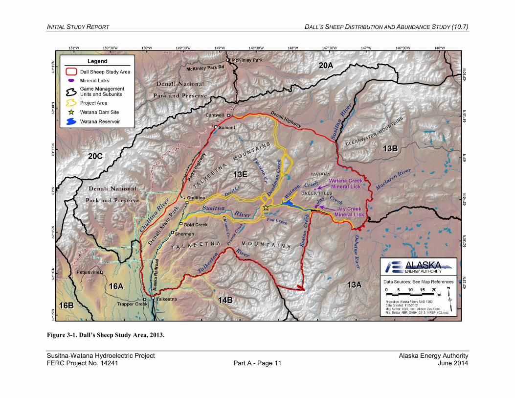
Figure 3-1. Dall’s Sheep Study Area, 2013. ................................................................................. 11
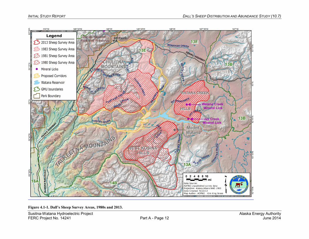
Figure 4.1-1. Dall’s Sheep Survey Areas, 1980s and 2013. ......................................................... 12
Figure 5.1-1. Locations of Dall’s Sheep Observed on Aerial Surveys, 2013. .............................. 13
Figure 5.2-1. Maximum Daily Number of Individual Sheep Visible in Photos of the Jay Creek Mineral Lick, 2013. ............................................................................................................... 14
LIST OF ACRONYMS, ABBREVIATIONS, AND DEFINITIONS
Abbreviation Definition ADF&G Alaska Department of Fish and Game AEA Alaska Energy Authority APA Alaska Power Authority FERC Federal Energy Regulatory Commission GMU Game Management Unit ILP Integrated Licensing Process ISR Initial Study Report PRM Project River Mile Project Susitna-Watana Hydroelectric Project No. 14241 RSP Revised Study Plan SPD study plan determination
INITIAL STUDY REPORT DALL’S SHEEP DISTRIBUTION AND ABUNDANCE STUDY (10.7)
Susitna-Watana Hydroelectric Project Alaska Energy Authority FERC Project No. 14241 Part A - Page 1 June 2014
1. INTRODUCTION
On December 14, 2012, Alaska Energy Authority (AEA) filed with the Federal Energy Regulatory Commission (FERC or Commission) its Revised Study Plan (RSP) for the Susitna-Watana Hydroelectric Project No. 14241 (Project), which included 58 individual study plans (AEA 2012). On February 1, 2013, FERC staff issued its study plan determination (February 1 SPD) for 44 of the 58 studies, approving 31 studies as filed and 13 with modifications. RSP Section 10.7, the Dall’s Sheep Distribution and Abundance Study (Sheep Study), was one of the 31studies approved with no modifications. RSP Section 10.7 described the goals, objectives, and proposed methods for data collection regarding Dall’s sheep.
On February 1, 2013, FERC staff issued its study plan determination (February 1 SPD) for 44 of the 58 studies, approving 31 studies as filed and 13 with modifications. RSP Section 10.7 was one of the 31 approved with no modifications.
Following the first study season, FERC’s regulations for the Integrated Licensing Process (ILP) require AEA to “prepare and file with the Commission an initial study report describing its overall progress in implementing the study plan and schedule and the data collected, including an explanation of any variance from the study plan and schedule.” (18 CFR 5.15(c)(1)) This Initial Study Report (ISR) on the Dall’s Sheep Distribution and Abundance Study has been prepared in accordance with FERC’s ILP regulations and details AEA’s status in implementing the study, as set forth in the FERC-approved RSP (referred to herein as the “Study Plan”).
2. STUDY OBJECTIVES
The goal of this study is to obtain sufficient information on the minimum population size, summer distribution, and current use of mineral licks by Dall’s sheep—an important species of big game in the Project area—to use in evaluating potential Project-related effects and identifying measures to avoid, minimize, or otherwise mitigate those effects.
The study objectives are established in RSP Section 10.7.1:
1) Estimate the current minimum population size of Dall’s sheep in the study area.
2) Delineate the summer range of Dall’s sheep in the study area.
3) Evaluate the current condition of mineral licks in and near the Project area.
4) Analyze and synthesize data from historical and current studies of Dall’s sheep in the study area, as a continuation of the 2012 study (AEA 2012a).
3. STUDY AREA
As established by RSP Section 10.7.3, the study area, consists of that portion of Game Management Unit (GMU) Subunit 13E located east of the Parks Highway and south of the Denali Highway, encompassing the proposed Project facilities, potential access and transmission
INITIAL STUDY REPORT DALL’S SHEEP DISTRIBUTION AND ABUNDANCE STUDY (10.7)
Susitna-Watana Hydroelectric Project Alaska Energy Authority FERC Project No. 14241 Part A - Page 2 June 2014
line corridors, and reservoir inundation zone (Figure 3-1). All suitable Dall’s sheep habitat within the study area was surveyed by airplane and the mineral licks at Jay Creek and Watana Creek were visited on the ground.
4. METHODS AND VARIANCES IN 2013
The study comprised three components:
• Aerial surveys for summer distribution and minimum population estimation. • Inspection of the Jay Creek and Watana Creek mineral licks to assess their current
condition and general level of use. • Analysis of historical (1980s) data and synthesis with current Alaska Department of Fish
and Game (ADF&G) monitoring results.
4.1. Aerial Surveys
AEA implemented the methods described in the Study Plan, with no variances.
The study team enlisted the services of experienced biologists and fixed-wing survey pilots in July 2013 to document sheep distribution and to develop a minimum population estimate. The survey covered all suitable sheep habitat in the study area and followed standard ADF&G protocols for summer surveys after lambing and before the sheep hunting season begins in early August. Optimal survey conditions include a lack of turbulence, a lack of precipitation, minimal glare from direct sunlight, and clear visibility with no portion of the study area obscured by clouds or fog.
The study team divided the aerial survey study area into three survey blocks, based on the distribution of suitable habitat in GMU Subunit 13E: the Chulitna Mountains block southeast of Cantwell, the West Kosina Hills block south of the proposed reservoir inundation zone, and the Watana Creek Hills block north of the proposed reservoir inundation zone (Figure 4.1-1). The team surveyed each block using a small fixed-wing aircraft (Piper PA-18 “Super Cub”) flown along elevation contours at altitudes of 300–700 feet above ground level and airspeeds of 60–80 mph. If necessary for adequate coverage, the team completed two flight passes in areas with rough terrain. The study team classified sheep into the following categories: rams, lambs, ewes and ewe-like sheep. In addition to ewes, the ewes and ewe-like sheep category may include yearling rams, which are sometimes difficult to distinguish from ewes.
4.1.1. Variances
No variances from the methods described in the Study Plan were necessary in 2013.
4.2. Mineral Lick Surveys
AEA implemented the methods described in the Study Plan, with the exception of the variance described below in Section 4.2.1.
INITIAL STUDY REPORT DALL’S SHEEP DISTRIBUTION AND ABUNDANCE STUDY (10.7)
Susitna-Watana Hydroelectric Project Alaska Energy Authority FERC Project No. 14241 Part A - Page 3 June 2014
The study team visited the Jay Creek and Watana Creek mineral licks (Figure 3-1) twice in 2013, once during May (May 28–29) and once in June (June 19–20), to provide a qualitative assessment of lick condition and levels of use. AEA contractors performed these site visits rather than ADF&G personnel. Results were compared with those from ground-based surveys of mineral licks conducted in the 1980s (Tankersley 1984). Conducting site visits in both 2013 and 2014 will provide information on annual variability, and the results of the 2013 visits will be used to determine the timing of the 2014 field visits.
4.2.1. Variances
During the site visit to the Jay Creek mineral lick in May 2013, the study team deployed a time-lapse camera to record sheep presence on the main cliff face of the mineral lick, thereby providing a greater volume of data on lick use than would have resulted from the two site visits proposed in RSP Section 10.7.4. The time-lapse camera (Model PC900 from Reconyx, Inc., Holmen, WI) was programmed to record photographs at 10-minute intervals for 24 hours each day, although the cliff was only visible in photos taken during daylight hours. The study team placed the camera approximately 600 m from the main cliff face at the lick. That distance was relatively far for distinguishing sheep in the photographs but, because of local topography, the location selected was the best one from which to photograph the cliff face. The data obtained from the time-lapse photography provide additional information to use in achieving the study objective regarding characterization of mineral lick use.
4.3. Analysis of Historical Data
AEA implemented the methods as described in the Study Plan, with no variances.
The study team reviewed and synthesized data from historical and current studies of Dall’s sheep in the study area, as a continuation of the 2012 study (AEA 2012a). Aerial survey data and mineral lick observation data were compiled from various sources, including ADF&G management reports (Didrickson 1980; Kavalok 2005; Peltier 2011), the final report for the APA Project study in the 1980s (Tankersley 1984), and unpublished survey data and maps. Historic and current survey and observation data for Dall’s sheep were summarized to determine habitat use within the Project area, changes in population size, and use of the Jay Creek and Watana Creek mineral licks.
4.3.1. Variances
No variances from the methods described in the Study Plan were necessary in 2013.
5. RESULTS
Data developed in support of this study are available for download in the following file at http://gis.suhydro.org/reports/isr:
• ISR_10_7_DASH_Data_2013.accdb.
INITIAL STUDY REPORT DALL’S SHEEP DISTRIBUTION AND ABUNDANCE STUDY (10.7)
Susitna-Watana Hydroelectric Project Alaska Energy Authority FERC Project No. 14241 Part A - Page 4 June 2014
5.1. Aerial Surveys
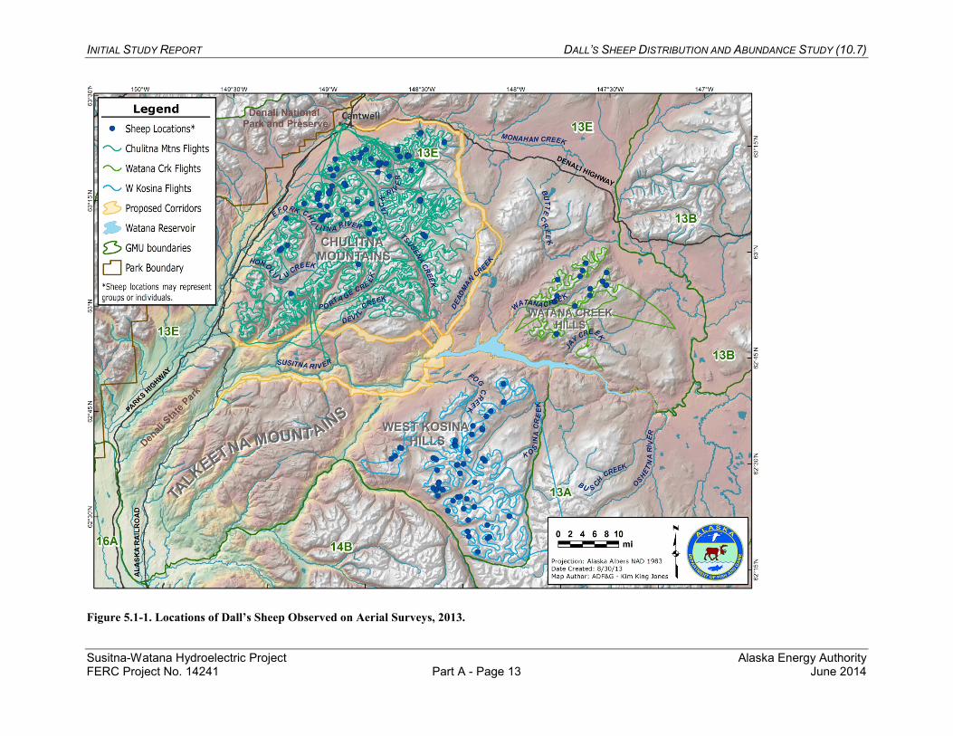
The study team counted a total of 512 Dall’s sheep in the study area over 32 survey hours (38 total flight hours) flown during July 11–30, 2013 (Figure 5.1-1). The weather was clear and calm during all survey flights, providing excellent survey conditions. The majority of the sheep (54 percent) were counted in the Chulitna Mountains. That survey block was the largest (2,520 km2) and had the most rugged terrain, so two flight passes (one higher and one lower) often were required to cover the area adequately. The Watana Creek Hills survey block was the smallest (522 km2) and only 41 sheep were counted in that area. A count of 194 sheep was recorded in the West Kosina Hills, the third survey block (Table 5.1-1). The ram/ewe and lamb/ewe ratios were similar among the three survey blocks, ranging from 62.6 to 63.6 rams per 100 ewes and 22.0 to 33.3 lambs per 100 ewes (Table 5.1-2).
5.2. Mineral Lick Surveys
Dall’s sheep were observed at the Jay Creek and Watana Creek mineral licks during site visits in May and June 2013 (Table 5.2-1). During the first visit on May 28–29, three rams were observed near the Watana Creek lick and another seven sheep were visible on the surrounding mountains. Three rams and one ewe were observed at the Jay Creek lick on the May visit. During the observation period, two of the rams left the cliff above Jay Creek and moved to the mountains north of the lick.
During the second site visit (June 19–20), two rams were observed near the Watana Creek lick and at least 15 other sheep were observed in the surrounding area. Two sheep were observed in a previously undescribed low-elevation mineral lick north of Watana Creek, approximately 1.2 miles northwest of the Watana Creek lick. Seven sheep (two rams, three ewes, one yearling, and one lamb) were present at the Jay Creek Lick on June 20. During the observation period, one ewe, the yearling, and both rams departed the lick and moved into the mountains to the northwest of the lick.
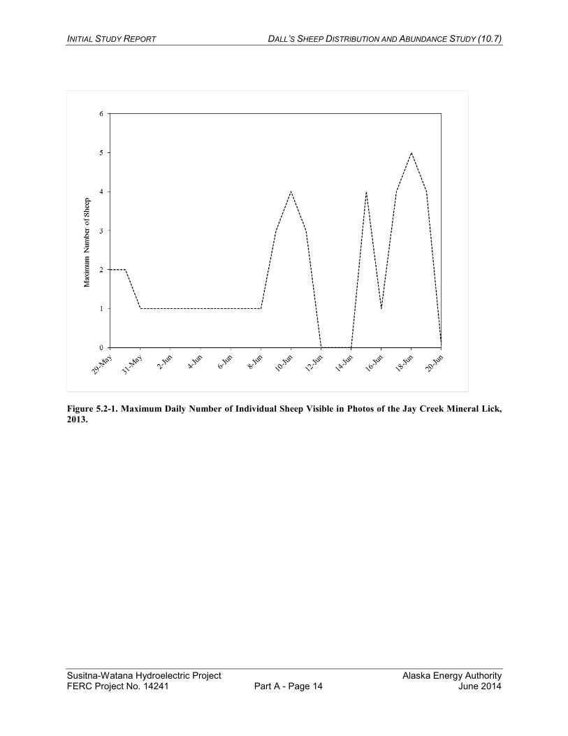
The time-lapse camera deployed at the Jay Creek lick on May 29 was knocked at an angle on May 30, most likely by a brown bear, but the majority of the main cliff face at the lick on the west side of the creek was still visible in photos. The long distance and displaced camera made identifying sheep in photos challenging, but sheep in open habitat were visible under good light conditions. The daily maximum number of sheep visible in each photo varied from 1–2 in late May and early June to 4 on June 10. The peak count from the photos was five sheep on June 18 (Figure 5.2-1). No sheep were visible in photos during June 12–14. On June 15, at least three sheep were visible on the hill east of Jay Creek, opposite the lick.
5.3. Analysis of Historical Data
Historical survey data for GMU 13E were compiled from ADF&G Dall’s sheep management reports (Didrickson 1980, Kavalok 2005, Peltier 2011), the APA Project final report on Dall’s sheep (Tankersley 1984), and unpublished data in ADF&G files.
INITIAL STUDY REPORT DALL’S SHEEP DISTRIBUTION AND ABUNDANCE STUDY (10.7)
Susitna-Watana Hydroelectric Project Alaska Energy Authority FERC Project No. 14241 Part A - Page 5 June 2014
6. DISCUSSION
6.1. Aerial Surveys
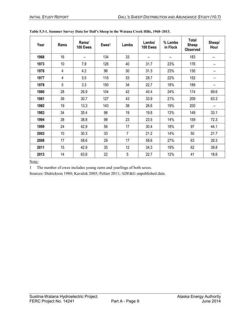
Survey conditions were excellent for the Dall’s sheep surveys in July 2013. The total number of sheep observed in the Watana Creek Hills was lower than has been documented in previous years and was less than a third of the population size documented during the 1983 sheep survey for the APA Project (Table 5.3-1; Tankersley 1984). The population in the Talkeetna Mountains (including the Watana Creek Hills) has not rebounded from the severe decline that occurred after the harsh winter of 1999–2000 (Peltier 2011). The ram/ewe ratio was higher in the Watana Creek Hills during the 2013 survey than has been observed historically in that area (Table 5.3-1), but was similar to the ram/ewe ratios observed in the Chulitna Mountains and West Kosina Hills survey blocks in 2013 (Table 5.1-2).
The 2013 survey areas in the Chulitna Mountains and West Kosina Hills were more extensive than were the survey areas covered historically, including the 1980s sheep surveys for the APA Project (Figure 4.1-1). Although a change in population size has not been documented in those two survey areas, it is likely that sheep there also experienced a population decline in the winter of 1999–2000, along with the Watana Creek Hills and other surveyed portions of the Talkeetna Mountains (Peltier 2011).
The majority of the sheep counted in the Chulitna Mountains survey area in 2013 were west of the Jack River and north of the East Fork of the Chulitna River (Figure 5.1-1). The 1980s surveys in the Chulitna Mountains covered only the peaks east and south of that area because of their proximity to the transportation corridors proposed at that time (Figure 4.1-1). In the surveys conducted in July 1980 and June 1983, 72 and 52 sheep were counted, respectively, in that portion of the Chulitna Mountains (ADF&G unpublished data; Tankersley 1984). In the July 2013 survey, 66 sheep were counted in the same area covered by the 1980s surveys. The results of the 2013 West Kosina Hills survey are not comparable to the results from the 1980 and 1981 surveys due to differences in the areas surveyed (Figure 4.1-1; ADF&G unpublished data).
6.2. Mineral Lick Surveys
During APA Project studies conducted in the 1980s, between 0 and 31 sheep were observed daily using the various locations comprising the Jay Creek mineral lick (Tankersley 1984). Some marked sheep remained at the lick for two to 15 days. Sheep of various sex and age classes used the lick, but only rams were present until May 28 and few rams were present after June 14. When at the lick, sheep spent 57.5% of the time on the main cliff face west of the creek. During the much less intensive observations conducted in 2013, the maximum count at the lick was seven sheep at one time, similar to the maximum count of five sheep in the time-lapse photos. The time-lapse photo counts are most likely undercounts of the total number of sheep using the lick, however, because only sheep in the open portions of the main cliff face were visible in the photos. Nevertheless, the observations in 2013 indicated that fewer sheep were using the Jay Creek lick than in the 1980s, consistent with the decline in the local sheep population observed in the time series of aerial surveys described above.
INITIAL STUDY REPORT DALL’S SHEEP DISTRIBUTION AND ABUNDANCE STUDY (10.7)
Susitna-Watana Hydroelectric Project Alaska Energy Authority FERC Project No. 14241 Part A - Page 6 June 2014
6.3. Analysis of Historical Data
Periodic aerial surveys of Dall’s sheep in summer have been conducted by ADF&G in the Watana Creek Hills since 1968 to develop minimum population estimates. Between 130 and 209 sheep were counted in the Watana Creek Hills during summer surveys from 1968 to 1994, whereas only 50 sheep were counted in the same area in 2003 (Table 5.3-1). Sheep populations in the Talkeetna Mountains (including the Watana Creek Hills) declined steeply after the winter of 1999–2000 and have since remained stable but low (Peltier 2008; Peltier 2011). Winter surveys in March 1968, 1981, and 1983 documented 97, 56, and 87 sheep, respectively, in the Watana Creek Hills (ADF&G unpublished data). Sightability of sheep is low during winter, so winter surveys are typically used to delineate winter range and are not used as population indices.
Dall’s sheep were studied more extensively in the Project region from 1977 to 1983 with additional survey areas in the northern portion of the West Kosina Hills (directly south of the proposed Watana impoundment) and in the Chulitna Mountains north and west of the proposed access corridors (Figure 4.1-1; ADF&G unpublished data; Tankersley 1984). In 1977, 34 sheep were observed on Mount Watana (in the northern portion of the West Kosina Hills). No sheep were counted on Mount Watana during sheep surveys conducted in July 1980 or March and July 1983 (ADF&G unpublished data; Tankersley 1984). In July 1980 and March 1981, nine and 22 sheep were counted, respectively, in the northern portion of the West Kosina Hills. However, the results of these surveys are not comparable due to differences in the areas surveyed (Figure 4.1-1; ADF&G unpublished data).
A portion of the Chulitna Mountains north of the proposed Chulitna access corridor and west of the proposed Denali access corridor was surveyed in July 1980 and in March and June 1983, yielding counts of 72, 30, and 52 sheep, respectively (Figure 4.1-1; ADF&G unpublished data; Tankersley 1984). Most of the sheep were found in the East Fork of the Jack River and the upper Tsusena Creek drainage. No sheep were found within 2.5 miles of the proposed access corridors (ADF&G unpublished data; Tankersley 1984).
During the 1980s research, mineral licks were identified on lower Jay Creek and upper Watana Creek (Tankersley 1984). Sheep used those licks mainly between mid-May and mid-June. A total of 21 sheep in the Watana Creek Hills were color-marked with paint pellets in April 1983. At least 31 percent of the sheep population observed in the Watana Creek Hills in 1983 traveled 5 miles or more to the Jay Creek lick (Tankersley 1984).
7. COMPLETING THE STUDY
[Section 7 appears in the Part C section of this ISR.]
INITIAL STUDY REPORT DALL’S SHEEP DISTRIBUTION AND ABUNDANCE STUDY (10.7)
Susitna-Watana Hydroelectric Project Alaska Energy Authority FERC Project No. 14241 Part A - Page 7 June 2014
8. LITERATURE CITED
AEA (Alaska Energy Authority). 2012a. W-S1: Big-game movement and habitat use study for the Susitna–Watana Hydroelectric Project, FERC Project No. 14241. Draft final version (March 21, 2012). Alaska Energy Authority, Anchorage.
AEA. 2012b. Revised Study Plan: Susitna-Watana Hydroelectric Project FERC Project No. 14241. December 2012. Prepared for the Federal Energy Regulatory Commission by the Alaska Energy Authority, Anchorage, Alaska. http://www.susitna-watanahydro.org/study-plan.
Didrickson, J. C. 1980. Game Management Units 13 and 14—Talkeetna Mountains. In R. Hinman, editor. Annual report of survey-inventory activities: Part III. Deer, elk, marine mammals, mountain goats, and sheep. Vol. X. Alaska Department of Fish and Game. Juneau, Alaska. 99 pp.
Kavalok, T. P. 2005. Units 13A, 13E, 14A (north), and 14B Dall sheep management report. Pages 80–90 in C. Brown, editor. Dall sheep management report of survey and inventory activities 1 July 2001–30 June 2004. Alaska Department of Fish and Game. Project 6.0. Juneau, Alaska.
Peltier, T. C. 2008. Units 13A, 13E, 14A (North) and 14B Dall sheep management report. Pages 90–97 in P. Harper, editor. Dall sheep management report of survey-inventory activities 1 July 2004–30 June 2007. Alaska Department of Fish and Game. Project 6.0. Juneau, Alaska.
Peltier, T. C. 2011. Units 13A, 13E, 14A (North) and 14B Dall sheep management report. Pages 72–79 in P. Harper, editor. Dall sheep management report of survey-inventory activities 1 July 2007–30 June 2010. Alaska Department of Fish and Game. Project 6.0. Juneau, Alaska.
Tankersley, N. 1984. Susitna Hydroelectric Project, final report, big game studies, Vol. VIII—Dall sheep. Report by Alaska Department of Fish and Game, Anchorage, for the Alaska Power Authority, Anchorage. 91 pp.
INITIAL STUDY REPORT DALL’S SHEEP DISTRIBUTION AND ABUNDANCE STUDY (10.7)
Susitna-Watana Hydroelectric Project Alaska Energy Authority FERC Project No. 14241 Part A - Page 8 June 2014
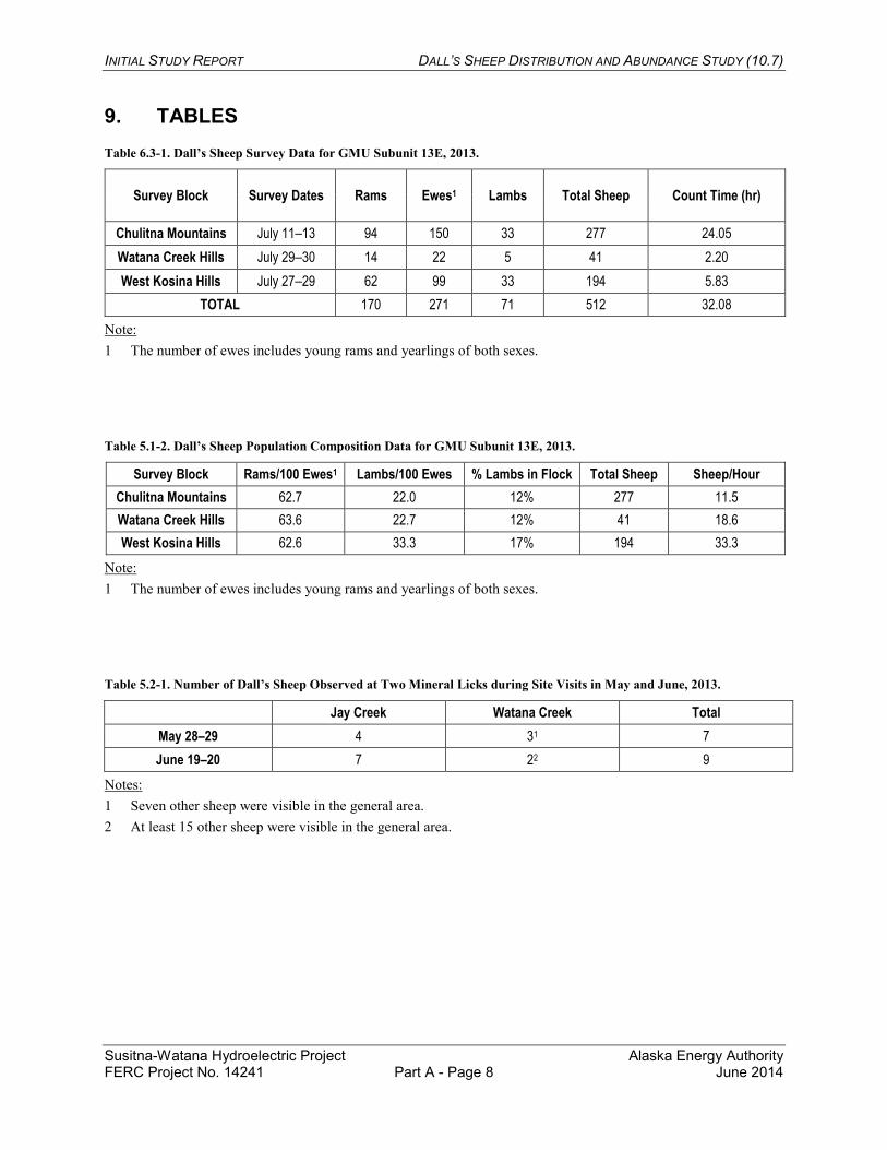
9. TABLES Table 6.3-1. Dall’s Sheep Survey Data for GMU Subunit 13E, 2013.
Note: 1 The number of ewes includes young rams and yearlings of both sexes.
Table 5.1-2. Dall’s Sheep Population Composition Data for GMU Subunit 13E, 2013.
Survey Block Rams/100 Ewes1 Lambs/100 Ewes % Lambs in Flock Total Sheep Sheep/Hour Chulitna Mountains 62.7 22.0 12% 277 11.5 Watana Creek Hills 63.6 22.7 12% 41 18.6 West Kosina Hills 62.6 33.3 17% 194 33.3
Note: 1 The number of ewes includes young rams and yearlings of both sexes.
Table 5.2-1. Number of Dall’s Sheep Observed at Two Mineral Licks during Site Visits in May and June, 2013.
Jay Creek Watana Creek Total May 28–29 4 31 7 June 19–20 7 22 9
Notes: 1 Seven other sheep were visible in the general area. 2 At least 15 other sheep were visible in the general area.
Survey Block Survey Dates Rams Ewes1 Lambs Total Sheep Count Time (hr)
Chulitna Mountains July 11–13 94 150 33 277 24.05 Watana Creek Hills July 29–30 14 22 5 41 2.20 West Kosina Hills July 27–29 62 99 33 194 5.83
TOTAL 170 271 71 512 32.08
INITIAL STUDY REPORT DALL’S SHEEP DISTRIBUTION AND ABUNDANCE STUDY (10.7)
Susitna-Watana Hydroelectric Project Alaska Energy Authority FERC Project No. 14241 Part A - Page 9 June 2014
Table 5.3-1. Summer Survey Data for Dall’s Sheep in the Watana Creek Hills, 1968–2013.
Year Rams Rams/ 100 Ewes Ewes1 Lambs Lambs/
100 Ewes % Lambs in Flock
Total Sheep
Observed Sheep/ Hour
1968 16 – 134 33 – – 183 – 1973 10 7.9 126 40 31.7 23% 176 – 1976 4 4.2 96 30 31.3 23% 130 – 1977 4 3.5 115 33 28.7 22% 152 – 1978 5 3.3 150 34 22.7 18% 189 – 1980 28 26.9 104 42 40.4 24% 174 69.6 1981 39 30.7 127 43 33.9 21% 209 63.3 1982 19 13.3 143 38 26.6 19% 200 – 1983 34 35.4 96 19 19.8 13% 149 33.1 1994 38 38.8 98 23 23.5 14% 159 72.3 1999 24 42.9 56 17 30.4 18% 97 44.1 2003 10 30.3 33 7 21.2 14% 50 21.7 2008 17 58.6 29 17 58.6 27% 63 26.3 2011 15 42.9 35 12 34.3 19% 62 38.8 2013 14 63.6 22 5 22.7 12% 41 18.6
Note: 1 The number of ewes includes young rams and yearlings of both sexes. Sources: Didrickson 1980; Kavalok 2005; Peltier 2011; ADF&G unpublished data.
INITIAL STUDY REPORT DALL’S SHEEP DISTRIBUTION AND ABUNDANCE STUDY (10.7)
Susitna-Watana Hydroelectric Project Alaska Energy Authority FERC Project No. 14241 Part A - Page 10 June 2014
10. FIGURES
INITIAL STUDY REPORT DALL’S SHEEP DISTRIBUTION AND ABUNDANCE STUDY (10.7)
Susitna-Watana Hydroelectric Project Alaska Energy Authority FERC Project No. 14241 Part A - Page 11 June 2014
Figure 3-1. Dall’s Sheep Study Area, 2013.
INITIAL STUDY REPORT DALL’S SHEEP DISTRIBUTION AND ABUNDANCE STUDY (10.7)
Susitna-Watana Hydroelectric Project Alaska Energy Authority FERC Project No. 14241 Part A - Page 12 June 2014
Figure 4.1-1. Dall’s Sheep Survey Areas, 1980s and 2013.
INITIAL STUDY REPORT DALL’S SHEEP DISTRIBUTION AND ABUNDANCE STUDY (10.7)
Susitna-Watana Hydroelectric Project Alaska Energy Authority FERC Project No. 14241 Part A - Page 13 June 2014
Figure 5.1-1. Locations of Dall’s Sheep Observed on Aerial Surveys, 2013.
INITIAL STUDY REPORT DALL’S SHEEP DISTRIBUTION AND ABUNDANCE STUDY (10.7)
Susitna-Watana Hydroelectric Project Alaska Energy Authority FERC Project No. 14241 Part A - Page 14 June 2014
Figure 5.2-1. Maximum Daily Number of Individual Sheep Visible in Photos of the Jay Creek Mineral Lick, 2013.