SURVEY OF MANDORA MOUND SPRINGS AND SALT CREEK, WALYARTA · SURVEY OF MANDORA MOUND SPRINGS AND...
26
SURVEY OF MANDORA MOUND SPRINGS AND SALT CREEK, WALYARTA Valerie English, Robyn Luu and Michael Coote 15 September 2016
Transcript of SURVEY OF MANDORA MOUND SPRINGS AND SALT CREEK, WALYARTA · SURVEY OF MANDORA MOUND SPRINGS AND...

SURVEY OF MANDORA MOUND SPRINGS AND SALT CREEK,
WALYARTA
Valerie English, Robyn Luu and Michael Coote
15 September 2016
1
BACKGROUND
Mandora Marsh is located 140 km sou’-sou’-west of Broome, approximately 40 km inland from
Eighty-Mile Beach and lies at the transition between the Pilbara and Kimberley Regions, on the
northern edge of the Great Sandy Desert (Storey et al. 2011). It supports a number of unique
and unusual geomorphological and biological features, with the areas’ characteristics forming
over thousands of years on a paleao-river system (Graham 1999). Mandora Marsh is listed in the
Directory of Important Wetlands of Australia (Environment Australia 2001), and also forms part
of the Eighty-mile Beach Wetland of International Importance listed under the Ramsar
Convention, based on the utilisation by migratory birds and landform values.
The Mandora Marsh system incorporates Mandora Lake (a large saline pan known as Nyamaringu
in the traditional Nyangumarta language), samphire flats, an endoreic (closed) salt water creek
(Salt Creek), salt and freshwater mound springs (Mandora Mound Springs), and the underlying
aquifer. Salt Creek and freshwater mound springs are two components that may potentially be
threatened by hydrological changes.
Salt Creek is a small, permanent, saline creek occurring 50 km inland. It measures approximately
10 km long and 2 m deep and is supplied by groundwater discharge and saline seeps from
adjacent claypans (Graham 1999; Storey et al. 2011). Salt Creek contains a unique occurrence of
inland mangroves (Avicennia marina), a species which is traditionally located in marine habitats
(Beard 1967).
The Mandora Mound Springs comprise fresh to brackish spring-fed swamps with peaty
substrates, many of which form raised (to 3m) peat mounds over the source of the spring.
Generally the mounds are surrounded by a freshwater moat varying in depth from damp soil to
up to 0.4 m deep and are associated with aquatic or emergent vegetation (Hale and Butcher
2009; Storey et al. 2011). There are 16 occurrences of the mound springs scattered over the
proposed Walyarta Conservation Park. Six occurrences were identified by Graham (1999) and
include Fern Spring, Linear Spring, Melaleuca Spring, Stockyard Mounds, Top Spring/Sump
Spring, Sporobolus Spring. Five occurrences were identified during a 2001 survey by Sally Black,
Tim Willing, Dave Dureau in August 2001 (Spring 1 to 5); and four occurrences were already
known (Saunders Spring, Grants Spring, Eil Eil Spring, Little Eil Eil Spring). The mound springs
occupy approximately 52 hectares, varying in size from less than one hectare to over 11
hectares.
All occurrences of the Mandora Mound Springs and Salt Creek occur within the ex-Anna Plains
Station (Walyarta) pastoral leasehold (now Unallocated Crown Land, planned for joint
management with Native Title Groups as Conservation Park). All pastoral leases issued under the
Land Act 1933 expired on 30th June 2015 and under the Land Administration Act 2000, an
2
opportunity was available to exclude an area from lease renewals for purposes such as
conservation. A financial agreement was reached with the leaseholder to exclude the Mandora
Salt Marsh from the lease renewal as of the 30th June 2015, with the area to be managed for
conservation (Hale and Butcher 2009). Previously the primary land use at the Anna Plains Station
was cattle grazing. The mound springs have been subject to cattle over many years in their
pursuit of water, fodder and shelter. Although it is Parks and Wildlife’s intention to manage the
area for conservation purposes, cattle still remain on the station and pose one of the biggest
threats to the Mandora Marsh (DEC 2009; Hale and Butcher 2009). Changes to hydrology,
including groundwater extraction for irrigation, industry and water supply, are also a major
threat to the Mandora Marsh Mound Springs.
The assemblages of the organic springs and mound springs of Mandora Marsh area community
was endorsed as an endangered threatened ecological community (TEC) by the WA Minister for
the Environment on 8 May 2002. The inland mangroves community of Salt Creek is listed as a
Priority 1 ecological community by the Department of Parks and Wildlife.
OBJECTIVES
A survey of various aspects of the biota and hydrology of Walyarta was completed between 31
August and10 September 2015 by a team with expertise in terrestrial fauna, flora and
vegetation, wetland invertebrate fauna, hydrogeology, and ecology, with Nyangumarta
traditional owners. This report covers the surveys of the threatened ecological community (TEC)
‘Assemblages of the organic springs and mound springs of Mandora Marsh area’ and the
Priority 1 ecological community (PEC) ‘inland mangroves community of Salt Creek ‘completed by
Valerie English and Michael Coote. The survey was completed to gather information as a basis
for a recovery plan for the two communities including describing the substrate and vegetation
structure, condition, threats and recommendations for management.
Other work that has significant linkages to this survey of the springs includes the invertebrate
surveys and hydrogeological studies of the springs. The results of these studies will have a
significant influence on the content of the recovery plan for the mound springs and Salt Creek.
METHODS
In addition to locations on Salt Creek, the following 13 mound springs were surveyed:
Saunders Spring
Grants Spring
Fern Spring
Top/Sump Spring
Melaleuca Spring
3
Camp Spring
Eil Eil Spring
Little Eil Eil Spring
Stockyard Mound Springs No. 1
Stockyard Mound Springs No. 2
Stockyard Mound Springs No. 3
Stockyard Mound Springs No. 4
Stockyard Mound Springs No. 5
Several other mound springs occur on the eastern portion of Walyarta but were inaccessible due
to very difficult vehicle access, and presence of male access only ceremonial and mythological
sites as follows:
Sporobolus Spring
‘Spring 1
‘Spring 2’
‘Spring 3’
‘Spring 4’
‘Spring 5’
The mound springs and Salt Creek were surveyed as follows:
TEC/PEC report forms were completed for all springs visited, and for Salt Creek. The
forms include information about soil and landform, flora taxa, vegetation structure,
threatening processes, management recommendations and completed actions. These
data have been added to the corporate TEC/PEC database.
Flora specimens were collected from the central core mound spring areas, the moat
areas that surround the springs, and from the dense shrublands that surround the moat
areas of the mound springs. Flora was also sampled from the immediate surrounds of
Salt Creek at the main crossing. Appendix 1 contains flora lists for mound springs and
Salt Creek. The flora specimens were provided to the WA Herbarium for identification,
and lodging where suitable. Once specimens have been identified, the data will be added
to the corporate TEC/PEC database.
Two specimens of microbial mats were collected from Salt Creek for DNA analysis to
characterise the microbial communities using a barcoded pyrosequencing approach.
Results of hydrogeological studies have not been included herein as they will be detailed in
other reports, but the following data will be included in the recovery plan:

4
Water quality data
Peat studies about influence of recent and longer term climate variation on flora that
facilitate peat accumulation
Studies about the underlying hydrology that drives the springs, and potential threats to
the long term hydrology such as regional drawdown or impacts to water quality.
LIMITATIONS
Eastern occurrences of the Mound Springs were not accessible as they include Aboriginal Sites.
These are ‘Springs 1-5’ and Sporobolus Spring, see figure below.
RESULTS
Locations of Mandora Mound Springs and Salt Creek
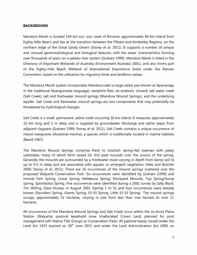
Saunders Spring consists of three discharge points (see figure below); one of the spring areas is
large (200m x 100m) and surrounded by a moat, two are much smaller with little peat
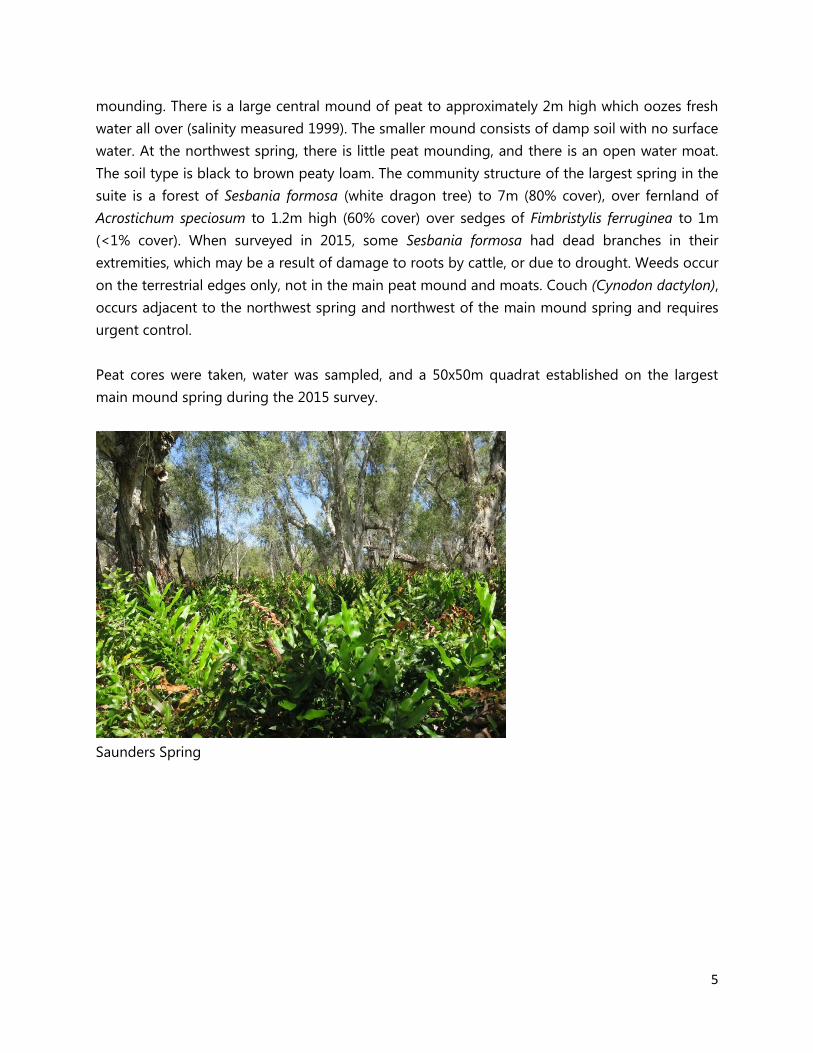
5
mounding. There is a large central mound of peat to approximately 2m high which oozes fresh
water all over (salinity measured 1999). The smaller mound consists of damp soil with no surface
water. At the northwest spring, there is little peat mounding, and there is an open water moat.
The soil type is black to brown peaty loam. The community structure of the largest spring in the
suite is a forest of Sesbania formosa (white dragon tree) to 7m (80% cover), over fernland of
Acrostichum speciosum to 1.2m high (60% cover) over sedges of Fimbristylis ferruginea to 1m
(<1% cover). When surveyed in 2015, some Sesbania formosa had dead branches in their
extremities, which may be a result of damage to roots by cattle, or due to drought. Weeds occur
on the terrestrial edges only, not in the main peat mound and moats. Couch (Cynodon dactylon),
occurs adjacent to the northwest spring and northwest of the main mound spring and requires
urgent control.
Peat cores were taken, water was sampled, and a 50x50m quadrat established on the largest
main mound spring during the 2015 survey.
Saunders Spring

6
Saunders Spring: three discharge areas
Grants Spring consists of a central peat mound approximately 100m by 50m, and 2m high of
black peaty clay loam surrounded by 10m wide moat on three sides, with water to 0.4m deep
when surveyed in September 2015. The central mound consists of 80% cover of Sesbania
formosa to 10m high, over Fimbristylis ferruginea sedges to 1m high (5% cover). Adjacent
vegetation consists of dense shrubland to 90% cover of Acacia ampliceps and Melaleuca
alsophila. The spring has been long impacted by cattle (young Sesbania pushed over), with
almost no vegetation remaining under dragon trees on the mound, and high level damage and
little vegetation remaining in the moat. The moat probably used to be a dense sedgeland, and
the mound may historically have been covered in ferns. There is no weed invasion on the main
peat mound or in the moats, only in the terrestrial edge. Buffel grass (Cenchrus ciliaris) occurs
adjacent to the south west side of the spring and requires urgent control.
7
Grants Spring; cattle damage
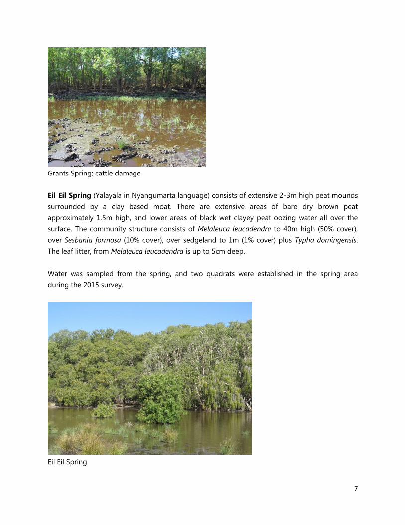
Eil Eil Spring (Yalayala in Nyangumarta language) consists of extensive 2-3m high peat mounds
surrounded by a clay based moat. There are extensive areas of bare dry brown peat
approximately 1.5m high, and lower areas of black wet clayey peat oozing water all over the
surface. The community structure consists of Melaleuca leucadendra to 40m high (50% cover),
over Sesbania formosa (10% cover), over sedgeland to 1m (1% cover) plus Typha domingensis.
The leaf litter, from Melaleuca leucadendra is up to 5cm deep.
Water was sampled from the spring, and two quadrats were established in the spring area
during the 2015 survey.
Eil Eil Spring
8
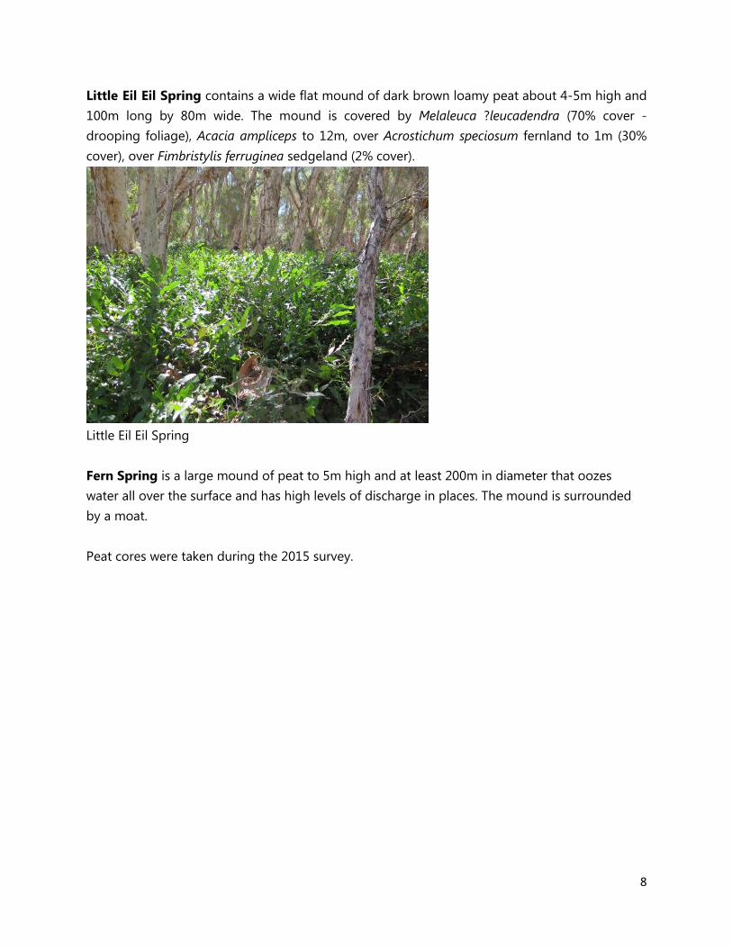
Little Eil Eil Spring contains a wide flat mound of dark brown loamy peat about 4-5m high and
100m long by 80m wide. The mound is covered by Melaleuca ?leucadendra (70% cover -
drooping foliage), Acacia ampliceps to 12m, over Acrostichum speciosum fernland to 1m (30%
cover), over Fimbristylis ferruginea sedgeland (2% cover).
Little Eil Eil Spring
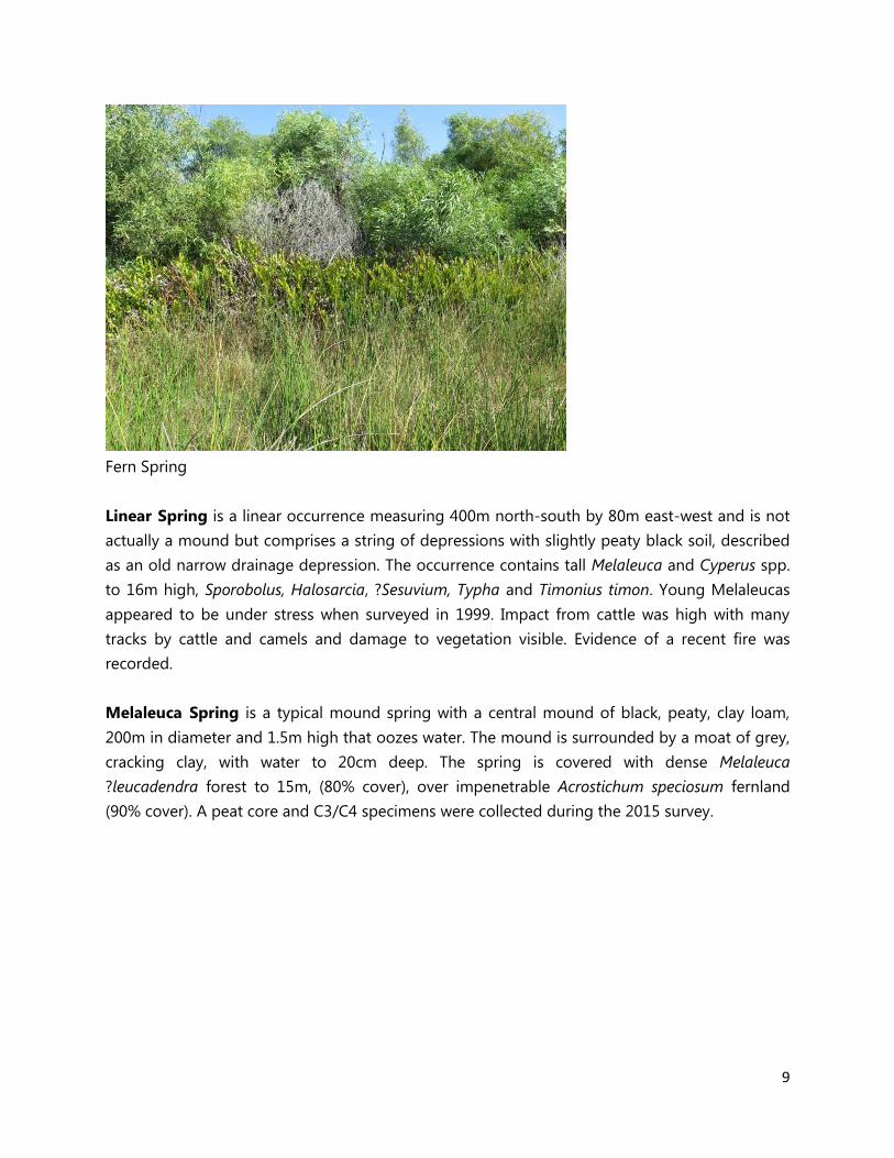
Fern Spring is a large mound of peat to 5m high and at least 200m in diameter that oozes
water all over the surface and has high levels of discharge in places. The mound is surrounded
by a moat.
Peat cores were taken during the 2015 survey.
9
Fern Spring
Linear Spring is a linear occurrence measuring 400m north-south by 80m east-west and is not
actually a mound but comprises a string of depressions with slightly peaty black soil, described
as an old narrow drainage depression. The occurrence contains tall Melaleuca and Cyperus spp.
to 16m high, Sporobolus, Halosarcia, ?Sesuvium, Typha and Timonius timon. Young Melaleucas
appeared to be under stress when surveyed in 1999. Impact from cattle was high with many
tracks by cattle and camels and damage to vegetation visible. Evidence of a recent fire was
recorded.
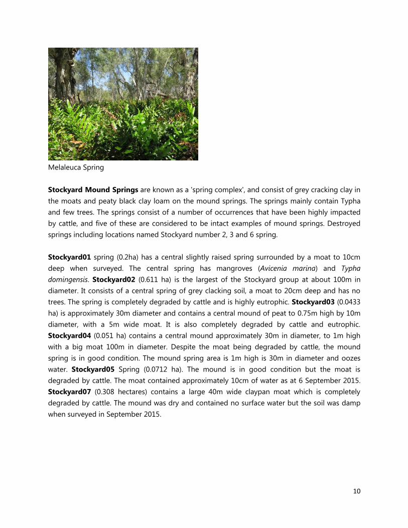
Melaleuca Spring is a typical mound spring with a central mound of black, peaty, clay loam,
200m in diameter and 1.5m high that oozes water. The mound is surrounded by a moat of grey,
cracking clay, with water to 20cm deep. The spring is covered with dense Melaleuca
?leucadendra forest to 15m, (80% cover), over impenetrable Acrostichum speciosum fernland
(90% cover). A peat core and C3/C4 specimens were collected during the 2015 survey.
10
Melaleuca Spring
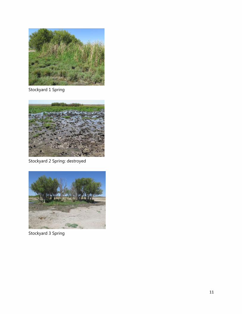
Stockyard Mound Springs are known as a 'spring complex', and consist of grey cracking clay in
the moats and peaty black clay loam on the mound springs. The springs mainly contain Typha
and few trees. The springs consist of a number of occurrences that have been highly impacted
by cattle, and five of these are considered to be intact examples of mound springs. Destroyed
springs including locations named Stockyard number 2, 3 and 6 spring.
Stockyard01 spring (0.2ha) has a central slightly raised spring surrounded by a moat to 10cm
deep when surveyed. The central spring has mangroves (Avicenia marina) and Typha
domingensis. Stockyard02 (0.611 ha) is the largest of the Stockyard group at about 100m in
diameter. It consists of a central spring of grey clacking soil, a moat to 20cm deep and has no
trees. The spring is completely degraded by cattle and is highly eutrophic. Stockyard03 (0.0433
ha) is approximately 30m diameter and contains a central mound of peat to 0.75m high by 10m
diameter, with a 5m wide moat. It is also completely degraded by cattle and eutrophic.
Stockyard04 (0.051 ha) contains a central mound approximately 30m in diameter, to 1m high
with a big moat 100m in diameter. Despite the moat being degraded by cattle, the mound
spring is in good condition. The mound spring area is 1m high is 30m in diameter and oozes
water. Stockyard05 Spring (0.0712 ha). The mound is in good condition but the moat is
degraded by cattle. The moat contained approximately 10cm of water as at 6 September 2015.
Stockyard07 (0.308 hectares) contains a large 40m wide claypan moat which is completely
degraded by cattle. The mound was dry and contained no surface water but the soil was damp
when surveyed in September 2015.
11
Stockyard 1 Spring
Stockyard 2 Spring: destroyed
Stockyard 3 Spring

12
Stockyard 4 Spring
Stockyard 5 Spring
Stockyard 6 Spring (destroyed)
Camp Spring is a relatively large spring, approximately 200m in diameter. It consists of a central
black clay flat surrounded by small mounds of black peaty clay to 2m high. The moat is grey
cracking clay and the water up to 20cm deep as at 1 September 2015. Dense dragon trees,
Melaleucas and Acacia ampliceps surround the central peat flat. The mounds have 30% cover of
Sesbania formosa, Melaleuca alsophila and Acacia ampliceps to 8m. The moat contains a
sedgeland of Fimbristylis ferruginea (50% cover). The spring is trampled by cattle but is still in
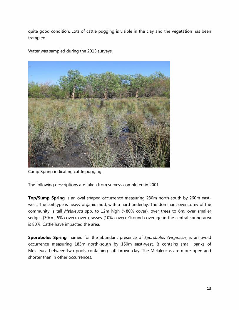
13
quite good condition. Lots of cattle pugging is visible in the clay and the vegetation has been
trampled.
Water was sampled during the 2015 surveys.
Camp Spring indicating cattle pugging.
The following descriptions are taken from surveys completed in 2001.
Top/Sump Spring is an oval shaped occurrence measuring 230m north-south by 260m east-
west. The soil type is heavy organic mud, with a hard underlay. The dominant overstorey of the
community is tall Melaleuca spp. to 12m high (>80% cover), over trees to 6m, over smaller
sedges (30cm, 5% cover), over grasses (10% cover). Ground coverage in the central spring area
is 80%. Cattle have impacted the area.
Sporobolus Spring, named for the abundant presence of Sporobolus ?virginicus, is an ovoid
occurrence measuring 185m north-south by 150m east-west. It contains small banks of
Melaleuca between two pools containing soft brown clay. The Melaleucas are more open and
shorter than in other occurrences.

14
Spring 1 is an oblong occurrence 50m in diameter. The community is dominated by a 12m
canopy of Melaleuca cajuputi and Sesbania formosa, ?Schoenoplectus understorey, with a moat
dominated by Typha around the outside edge.
Spring 2 is a circular occurrence measuring 120m north-south by 175m east-west. The mound is
dominated by Melaleuca cajuputi, Acacia ampliceps understory, and some Cynanchum carnosum
and Acrostichum speciosum. The moat contains Schoenoplectus spp. along the outer edge and
Melaleuca alsophila, Pseudoraphis spinescens, Sporobolus virginicus and Acacia ampliceps.
Spring 3 is a circular occurrence measuring 150m north-south by 190m east-west and is
surrounded by a moat. Drainage is numerous shallow massive outflow ponds. The community is
dominated by Sesbania formosa to 30m, Melaleuca cajuputi to 15m, and Acrostichum speciosum
understory. Also noted are Typha, Sporobolus, Pseudoraphis spinescens, Acacia ampliceps,
Cynanchum carnosum and Schoenoplectus sp.
Spring 4 is a circular occurrence measuring 100m in diameter and contains very fresh water. It
includes Melaleuca alsophila, Sporobolus virginicus, Typha, Sesbania formosa (southern end),
Pseudoraphis spinescens and some small Schoenoplectus sp. Cattle were observed at this spring
in 2001.
Spring 5 is a small, low, circular spring measuring 75m north-south by 100m east-west. It
contains Typha in the centre and is surrounded by Melaleuca alsophila (to 5m tall) and a ring of
Sporobolus.
Salt Creek
Salt Creek is a permanent creek approximately 10 km long and 2 m deep and covers an
estimated 40 hectares. The mangrove, Avicennia marina occurs to 6m tall with 80% cover, over a
grassland of Sporobolus virginicus to 30 cm high (15% cover), that occurs immediately adjacent
to the creek. The creek contains fresh to brackish water and occurs on calcrete soils.
THREATS
Grazing
Cattle are a major threat to the Mandora Mound springs and Salt Creek and have adverse
affects on their ecological health. Typically cattle will remain where they can access fresh water
and so have the tendency to stay at the springs for long periods during hot weather. They cause
physical damage to the mounds and the creek bed through trampling, resulting in erosion, as
well as grazing the regenerating vegetation, altering the species composition by selectively
15
removing edible species. Vegetation removal has the potential to cause an increase in drying of
the mound springs. Such damage is evident at Saunders Spring where root damage to trees
from cattle has probably resulted in deaths of branches on the tops of trees. In addition, at
Grant Spring cattle have pushed over young Sesbania and cleared most of the mound
vegetation, removing the ferns that mostly likely once covered the mound. The impacts of
grazing are most evident at the Stockyard complex however, with some springs now being
below the threshold ‘Good Condition’ (Bush Forever scales) applied to ‘extant’ TECs as a
consequence of major changes to structure and composition of native vegetation.
In addition to physical disturbance, faeces of cattle contaminate the soil and water, particularly
in the moat, causing nutrient enrichment. This may enhance the introduction of weeds as well as
elevate nutrient levels in the groundwater. Storey et al. (2011) recorded the occurrence of algal
blooms in the shallow moats around Melaleuca and Saunders Springs as well as elevated
nitrogen levels indicating nutrient enrichment. This adversely affects the aquatic invertebrates
that rely on the water supply.
Despite the excision of the mound springs and surrounds from the Anna Plains Station lease for
conservation purposes, cattle still remain in the areas. Fencing has served to reduce the impacts
of cattle with a number of individual springs, such as Saunders spring, and Grants Spring
previously fenced. An increase in invertebrate diversity within Saunders Mound springs recorded
between 1999 (Storey et al. 2011) and 2008 (DEC 2009) was likely attributed to a reduction in
cattle disturbance following fencing of the site in November 1997. The majority of fences are
damaged however and most are no longer effective.
Hydrological changes
Changes to hydrology are a major threat to the Mandora Mound Springs and to a lesser degree
Salt Creek. At a local scale, groundwater is exploited to provide drinking water for stock (DEC
2009). The extent of impacts to the mound springs is not clear however it is likely to affect the
aquatic flora and fauna that depend on the constant supply of freshwater. Mitchell (1985) found
that decreasing flow rates in mound springs in the arid north of South Australia from over
pumping of artesian bores resulted in a reduction in pool size, and likely changes to the aquatic
assemblages.
Trials were conducted in the late 1990s to grow irrigated cotton using groundwater extracted
from the La Grange sub-basin. Although this project did not progress, there are many
horticulture and centre pivot sprinkler developments emerging from Roebuck Plains in the north
to Pardoo in the south, and most stations in between. The Water for Food and La Grange
16
programs will no doubt result in an increase in water abstraction and land clearing in the area
and the impact of hydrological changes on the biota of the mound springs, Salt Creek, and
other nearby wetlands will require careful monitoring.
Feral animals
Feral animals, including camels, donkeys, foxes and cats are present in the mound springs and
Salt Creek in significant numbers. As with cattle, feral animals cause damage to the vegetation
through trampling and grazing and nutrient enrichment of the water. Carnivorous introduced
fauna can also predate on native species and disrupt waterbird breeding. The larger feral
animals such as camels and donkeys also damage the fences (DEC 2009; Graham 1999). The
apparent current low density of feral animals may be associated with a successful large cull
completed by Department of Agriculture and Food WA prior to 2012. These operations have
been discontinued however, and numbers are likely to increase.
Weed invasion
Currently weeds levels are not high within the Mandora Mound Springs and Salt Creek. Some
weed invasion has occurred, likely a result of the increase in nutrients and disturbance from
cattle. The weeds are mainly located within the moats, the thick vegetation of the mound
springs appearing to provide a barrier to reduce the likelihood of weed invasion. Couch
(Cynodon dactylon) a strongly invasive weed which is able to tolerate varying conditions, is
adjacent to Saunders Spring and requires urgent control. Kapok Bush (Aerva javanica) was
previously recorded at Saunders and Grants Springs; and Apple of Sodum (Solanum
linnaeanum) and Buffel Grass (Cenchrus ciliaris) have been recorded at Grants Spring (see
Appendix 2 for weed list).
Weeds change the natural diversity and balance of ecological communities and are a risk to the
Mandora Mound Springs. They displace native plants, particularly following disturbances such as
too frequent fire, grazing or partial clearing, and compete with them for light, nutrients and
water. Weeds can also prevent recruitment, cause changes to soil nutrients, and affect
abundance of native fauna. They can also impact on other conservation values by harbouring
pests and diseases, and increasing the fire risk.
Altered fire regimes
Inappropriate fire regimes are a potential risk to the Mandora Mound Springs and Salt Creek.
Historically, fire within the salt flats and mound springs was probably only very occasional. It is
likely that some of Walyarta’s ecosystems may be adapted to occasional fire as they contain
species that will easily carry fire when vegetation is dry, and some component shrubs would

17
reproduce from seed following fire. The impacts of fire, and fire regeneration response of the
mound spring peat substrate and vegetation needs to be determined on an opportunistic basis
following bush fire. Mound springs should not be included in routine burning as fires can cause
total destruction of peat based systems as it can smoulder for months, totally destroying peat
substrate that has accumulated over at least hundreds of years.
Drying climate
The Mandora Mound Springs and Salt Creek are at risk from a drying climate with effects such
as reduced surface water and groundwater recharge due to significantly less rainfall. A drying
climate as a threatening process is outside the scope of this report however.
CONCLUSIONS
The most significant ongoing threat to the integrity of the mound springs is grazing and
trampling by cattle. Hydrological change is probably the next most significant threat to the
future ecological function of the springs, as a series of large scale current developments and
future proposals have potential to impact the aquifers that maintain the springs.
Despite long term historical grazing by cattle, few significant weeds were noted in the springs
when surveyed in September 2015. The major weeds present do however have potential to
spread and have increased impacts on the springs in future and should be controlled as a matter
of urgency.
Impacts of feral animals including donkeys and camels are currently relatively low. There is little
evidence that altered fire regimes or climate change are having a significant impact on the
springs, but this may change in future.
RECOMMENDATIONS
While cattle are still present at Walyarta, repair existing fences at Saunders and Grants
Springs (a relatively inexpensive action).
Map significant weeds and control/eradicate them (including buffel grass at Grants
Spring 19.784550S; 121.35530E’ near the corner where fence is damaged), and Cynodon
dactylon (couch) at Saunders Spring (two locations: 19.782260S, 121.3367520E; and
19.7822490S, 121.3381220E) (a relatively inexpensive action). Other members of the
survey team may have noted other weeds and focus areas for control.

18
Design and implement quadrat based flora surveys to assist development of a
vegetation map for the Conservation Park (more costly and time consuming but essential
for management). New quadrats should also encompass the mound springs, as these
were not included in original quadrat work in 1999 but are probably the most sensitive
indicator of impacts to cattle, fire, weeds and hydrological change at Walyarta. The
additional quadrats can also be used as a basis for future monitoring.
Instigate a carefully designed monitoring program that provides information about the
success of land management in the sensitive environment of the Mandora Mound Spring
ecosystem.

19
REFERENCES
Beard, J.S. (1967) An Inland Occurrence of Mangrove. Western Australian Naturalist 10: 112–115.
Department of Environment and Conservation (2009) Resource Condition Report for a
Significant Western Australian Wetland: Saunders Spring. Prepared for Inland Aquatic
Integrity Resource Condition Monitoring (IAI RCM) Project. Department of Environment and
Conservation, Perth, Western Australia.
Department of Parks and Wildlife (2015) Conserving Threatened Species and Ecological
Communities. Corporate Policy Statement No. 35. Department of Parks and Wildlife, Western
Australia.
Department of Water (2012) West Canning Basin groundwater allocation limit report. Water
Resource Allocation and Planning Report Series 52. Department of Water, Perth, Western
Australia.
Environment Australia (2001) A Directory of Important Wetlands in Australia. Third Edition.
Environment Australia, Canberra.
Government of Western Australia (2000). Bush Forever. Volume 1: Policies, Principles and
Processes. Volume 2: Directory of Bush Forever Sites. Perth, W.A.
Graham, G. (1999) A Land Management Assessment of Mandora Marsh and its Immediate
Surrounds. Unpublished report to Environment Australia, Department of Conservation and
Land Management, Kununurra, Western Australia.
Hale, J. and Butcher, R. (2009) Ecological Character Description for the Eighty-mile Beach Ramsar
Site, Western Australia. Report to the Department of Environment and Conservation, Western
Australia.
Halse, S.A., Pearson, G.B., Hassell, C., Collins, P., Scanlon, M.D. and Minton, C.D.T. (2005) Mandora
Marsh, north-western Australia, an arid-zone wetland maintaining continental populations of
waterbirds. Emu 105: 115–125.
McFarlane, D. (2015) The Pilbara Water Resource Assessment: De Grey Canning Region. CSIRO
Land and Water, EP 157749.
Storey, A.W., Halse, S.A., Shiel, R.J. and Creagh, S. (2011) Aquatic fauna and water chemistry of
the mound springs and wetlands of Mandora Marsh, north-western Australia. Journal of the
Royal Society of Western Australia 94: 419–437.
Williams, A.F. and Holmes, J.W. (1978) A novel method of estimating the discharge of water from
mound springs of the Great Artesian Basin, Central Australia. Journal of Hydrology 38: 263–
272.
Wyrwoll, H., McKenzie, N.L., Pederson, B.J. and Tapley, I.J. (1986) The Great Sandy Desert of
northwestern Australia: the last 7000 years. Search 17: 208–210.

Appendix 1
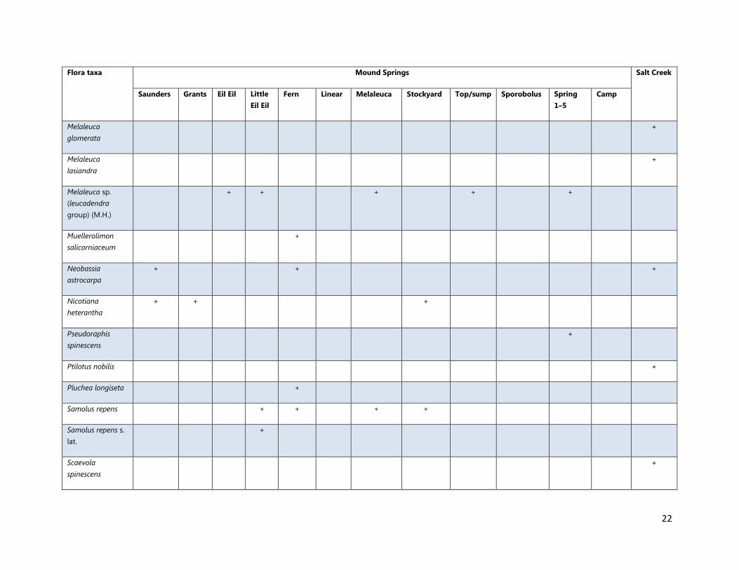
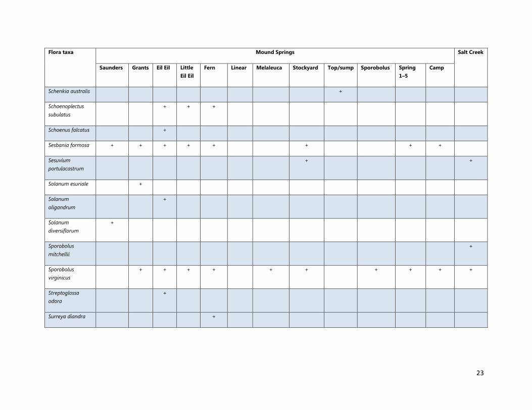
Flora in Mound Springs and Salt Creek communities occurrences, complied from historical and current survey data
Flora taxa Mound Springs Salt Creek
Saunders Grants Eil Eil Little
Eil Eil
Fern Linear Melaleuca Stockyard Top/sump Sporobolus Spring
1–5
Camp
Abutilon sp. sterile
(?fraseri) (M.H.)
+
Acacia ampliceps + + + + + + + + + + +
Acacia colei var.
colei
+
Acrostichum
speciosum
+ + + + +
Amaranthus
undulatus
+
Avicennia marina + +
Bauhinia
cunninghamii
+
Calandrinia
quadrivalvis
+ +
Cassytha filiformis + +
Cynanchum
carnosum
+ + + + +

21
Flora taxa Mound Springs Salt Creek
Saunders Grants Eil Eil Little
Eil Eil
Fern Linear Melaleuca Stockyard Top/sump Sporobolus Spring
1–5
Camp
Cyperus vaginatus +
Dysphania
plantaginella
+
Eragrostis
pergracilis
+ + +
Fimbristylis
ferruginea
+ + + + + + + +
Fimbristylis sp.
(M.H.)
+ + +
Frankenia ambita + + +
Grevillea
stenobotrya
+
Heliotropium
curassavicum
+ + +
Heliotropium
?pachyphyllum
(M.H.)
+ +
Lawrencia sp.
Anna Plains (N.T.
Burbidge 1433)
? + +
Melaleuca
alsophila
+ + + + + + + +
22
Flora taxa Mound Springs Salt Creek
Saunders Grants Eil Eil Little
Eil Eil
Fern Linear Melaleuca Stockyard Top/sump Sporobolus Spring
1–5
Camp
Melaleuca
glomerata
+
Melaleuca
lasiandra
+
Melaleuca sp.
(leucadendra
group) (M.H.)
+ + + + +
Muellerolimon
salicorniaceum
+
Neobassia
astrocarpa
+ + +
Nicotiana
heterantha
+ + +
Pseudoraphis
spinescens
+
Ptilotus nobilis +
Pluchea longiseta +
Samolus repens + + + +
Samolus repens s.
lat.
+
Scaevola
spinescens
+
23
Flora taxa Mound Springs Salt Creek
Saunders Grants Eil Eil Little
Eil Eil
Fern Linear Melaleuca Stockyard Top/sump Sporobolus Spring
1–5
Camp
Schenkia australis +
Schoenoplectus
subulatus
+ + +
Schoenus falcatus +
Sesbania formosa + + + + + + + +
Sesuvium
portulacastrum
+ +
Solanum esuriale +
Solanum
oligandrum
+
Solanum
diversiflorum
+
Sporobolus
mitchellii
+
Sporobolus
virginicus
+ + + + + + + + + +
Streptoglossa
odora
+
Surreya diandra +

24
Flora taxa Mound Springs Salt Creek
Saunders Grants Eil Eil Little
Eil Eil
Fern Linear Melaleuca Stockyard Top/sump Sporobolus Spring
1–5
Camp
Tecticornia
halocnemoides
?subsp.
longispicata (M.H.)
+
Tecticornia
halocnemoides
?subsp. tenuis
(M.H.)
+
Tecticornia indica
subsp. leiostachya
+ ? +
Tecticornia sp.
(sterile) (M.H.)
+ + + +
Timonius timon + + +
Trianthema
triquetrum
+ +
Trianthema
turgidifolium
+ + + +
Typha
domingensis
+ + + + + + + +
Xerochloa
imberbis
+ +
Zygophyllum
compressum
+ + +

25
Appendix 2
Weed taxa located in Mound Spring occurrences, complied from historical and current survey data
Weed taxon Saunder
s Spring
Grants
spring
Eil Eil
spring
Little
Eil Eil
spring
Fern spring Linear spring Melaleuca
spring
Stockyard
mounds
Top/sump
spring
Sporobolus
spring
Spring
1–5
Camp
spring
*Aerva javanica + +
#Cenchrus
ciliaris
+
@Cynodon
dactylon
+
*Flaveria
trinervia
+ + +
**Solanum
linnaeanum
+
# 19.784550S; 121.3553
0E
@ 19.78226
0S, 121.336752
0E; and 19.782249
0S, 121.338122
0E
*Various locations
**Historical records only, no specific locational data available