
6-1 Copyright © 2010 Pearson Education, Inc. Descriptive Research Design: Survey and Observation.
Survey Department in the Arena of Earth Observation
(A Brief Country Report)
Nagendra JhaChief Survey OfficerSurvey Department
Nepal
2nd GEOSS AP SymposiumApril 14-16, 2008
Japan
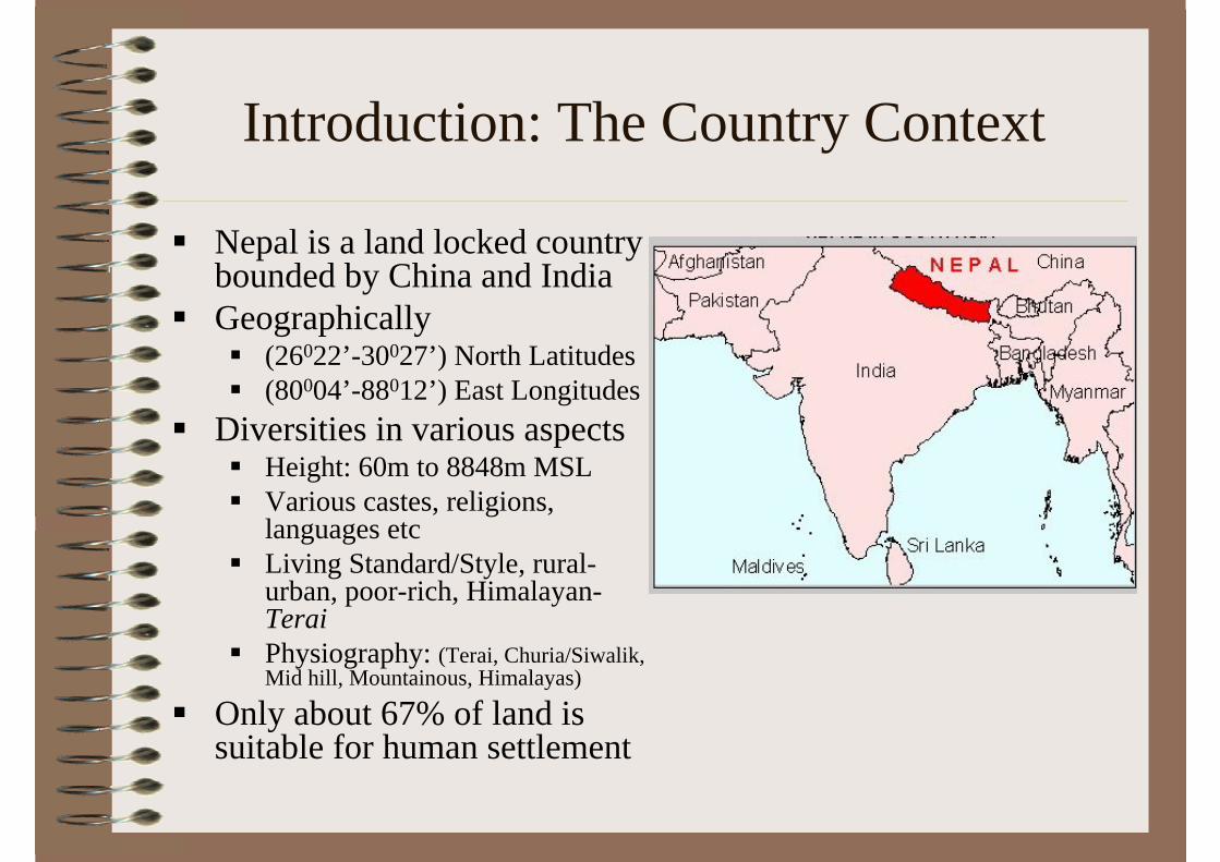
Introduction: The Country Context
Nepal is a land locked country bounded by China and IndiaGeographically
(26022’-30027’) North Latitudes(80004’-88012’) East Longitudes
Diversities in various aspectsHeight: 60m to 8848m MSLVarious castes, religions, languages etcLiving Standard/Style, rural-urban, poor-rich, Himalayan-TeraiPhysiography: (Terai, Churia/Siwalik, Mid hill, Mountainous, Himalayas)
Only about 67% of land is suitable for human settlement

Introduction…Satellite Image Map of Nepal
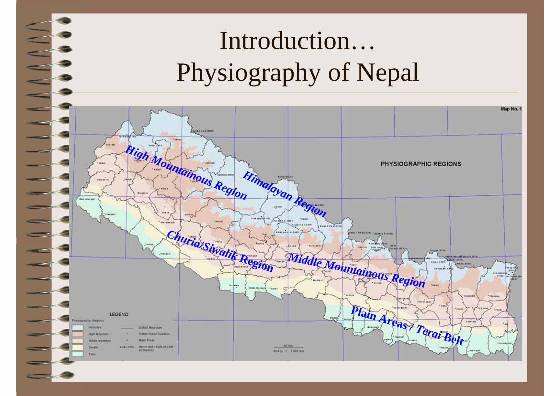
Introduction…Physiography of Nepal
Plain Areas / Terai Belt
Churia/Siwalik RegionMiddle Mountainous Region
High Mountainous Region
Himalayan Region
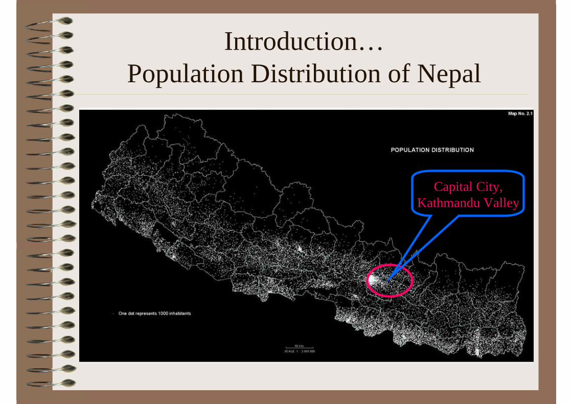
Introduction…Population Distribution of Nepal
Capital City, Kathmandu Valley

Survey Department
• Mandate from the government for surveying and mapping
• Focal Point for APRSAF• Member of other international organizations
GEO SNAC GSDIAFIG ISCGM AARSPCGIAP
Asia Pacific Regional Space Agency Forum, Group of Earth Observation, SAARC Networking Arrangement on Cartography, Global Spatial Data Infrastructure Association, Federation Internationale des Geometres, International Steering Committee for Global Mapping, Asian Association on Remote Sensing, Permanent Committee on GIS Infrastructure for Asia and the Pacific

Institutional Setup
Three main branches viz. Cadastral Survey Branch, Geodetic Survey Branch and Topographical Survey Branch. Nine Mobile Survey Offices locally called Survey Goswara responsible for cadastral survey in the districts. 83 district level Survey Offices taking care of updating cadastral maps and related records in association with the district level Land Revenue Offices in the districts. Some of the districts have more than one district level survey offices.

Institutional Setup…
• In the year 2002, National Geographic Information Infrastructure Programme (NGIIP) was initiated with one of the pronounced objectives of avoiding duplication in spatial data creation and improvement in usage through the networking of different GI Systems in the country.

OrganizationCadastral
Survey BranchSurvey
Department
Topographical Survey Branch
Geodetic Survey Branch
National Geographic Information Infrastructure
Programme
Napi Goswara(9)
District Survey Offices (83)

The present status of surveying and mapping
• By mid 1980s, land resources mapping was completed comprising basically of land utilization, land system, land capability and geological maps.
• New series of topographic base-maps were produced during 1992-2001.
• Newer technologies like remote-sensing, GIS and GPS were introduced in the 1990s.
• This decade also witnessed a growing use of maps and spatial data in decision-making at all levels of government and public governance and the private sector.
The present status of surveying and mapping ...
• Based on the new series of topographic maps DOSM has created digital spatial dataset termed as National Topographic Database (NTDB).
• In addition four successive levels of lower resolution datasets are under preparation to support data requirement at different scale such as district level, regional, national, and global level applications by generalizing the basic NTDB datasets
The present status of surveying and mapping ...
Satellite positioning has been introducedin establishing the control network at lower levels.to strengthen the existing national geodetic network complemented by precision levelling and gravimetric surveys.
A GPS tracking station has been commissioned to continuously track GPS data.

The present status of surveying and mapping ...
• Cadastral surveys of several districts have been undertaken to resurvey the districts that were surveyed in the past without using geodetic control.
• Cadastral survey offices have been established in all districts to look into the maintenance of cadastral records.
• Remote sensing has been introduced in updating basic topographic maps and data.

Roles and Efforts
Gradually changing its role of providing services to assuming a lead role in regulating the national surveying and mapping activities.
Its efforts are directed toward:Development of environment for meaningful sharing of geo-spatial information at largeFostering cooperation among the partner agencies including private sectors for developing institutional framework, policy directives etc.Development of human resource as requiredGradually transforming present pool of human resources receptive and adaptive to new technology.
Important activities
• The following sections overviews some of the activities of fundamental importance which were undertaken so far.

GII initiatives
• The NGII Programme was initiated with an overall objective of developing a National GII in the country.
• The programme aimed to develop a platform to facilitate data sharing among the Central Bureau of Statistics (CBS), Survey Department (DOSM) and four other participating ministries at the centre and 33 CBS Branch Statistical Offices at the districts.
• Published socio-economic atlas in hardcopy and CD-ROM format and has started disseminating the results through the web as well.
• Metadata system has been developed into an operational system.
Geodetic Surveys
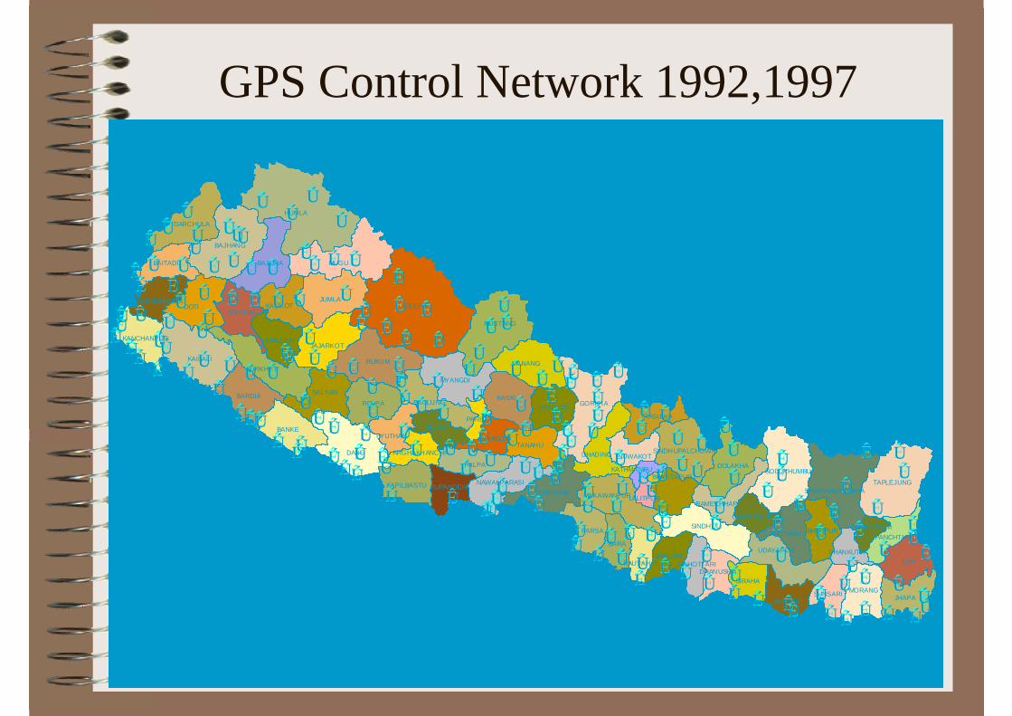
• A geodetic network of 68 first order geodetic points having 16 Doppler points has been established during 1981-84.
• Absolute gravity measurement at first order points and gravity transfer connecting Colombo and Bangkok.
• Extension of lower order geodetic network of the country has been completed in 47 districts out of 75 districts.
• Geodetic levelling net (6430 km) along the highways and roads of the country.
• Nine absolute gravity stations established. • Geoid Nepal 1997 defined based on gravity measurements
at some 1712 stations.• Geodetic observatory near Kathmandu served as the base
stations for triangulation. Star observations until 1990s. Now regular GPS measurements and is being developed into a permanent tracking station.
ÊÚ
ÊÚÊÚ
ÊÚÊÚÊÚ
ÊÚ
ÊÚ
ÊÚÊÚ
ÊÚ ÊÚ
ÊÚÊÚ
ÊÚÊÚ ÊÚ
ÊÚ
ÊÚÊÚÊÚÊÚ ÊÚ
ÊÚÊÚÊÚÊÚÊÚÊÚ ÊÚÊÚÊÚ
ÊÚ ÊÚÊÚÊÚ
ÊÚ
ÊÚÊÚÊÚ ÊÚÊÚ
ÊÚ
ÊÚ
ÊÚ
ÊÚ
ÊÚ
ÊÚÊÚÊÚ
ÊÚ
ÊÚ
ÊÚÊÚ ÊÚ
ÊÚ ÊÚÊÚ
ÊÚÊÚ
ÊÚÊÚÊÚÊÚ
ÊÚÊÚÊÚÊÚ
ÊÚÊÚÊÚ ÊÚ ÊÚ ÊÚ
ÊÚ ÊÚÊÚ
ÊÚÊÚÊÚ
ÊÚÊÚÊÚÊÚÊÚ ÊÚ
ÊÚÊÚ
ÊÚÊÚÊÚÊÚÊÚ ÊÚÊÚÊÚÊÚ
ÊÚÊÚÊÚ
ÊÚÊÚ
ÊÚÊÚ
ÊÚÊÚÊÚ
ÊÚÊÚ
ÊÚ ÊÚ
ÊÚ
ÊÚÊÚ
ÊÚ
ÊÚ
ÊÚÊÚÊÚ
ÊÚÊÚÊÚÊÚÊÚÊÚÊÚ
ÊÚÊÚÊÚ
ÊÚÊÚ ÊÚ
ÊÚ ÊÚÊÚÊÚÊÚ
ÊÚÊÚÊÚÊÚ
ÊÚÊÚÊÚ
ÊÚÊÚÊÚ
ÊÚ
ÊÚÊÚÊÚ
ÊÚÊÚ
ÊÚ ÊÚ ÊÚ ÊÚ ÊÚ ÊÚ ÊÚÊÚ
ÊÚ ÊÚ ÊÚ
ÊÚÊÚÊÚ
ÊÚÊÚÊÚÊÚ
ÊÚÊÚ
ÊÚÊÚ
ÊÚÊÚÊÚÊÚÊÚ
ÊÚÊÚ
ÊÚ
ÊÚÊÚ
ÊÚÊÚÊÚÊÚÊÚÊÚ
ÊÚÊÚ ÊÚ
ÊÚÊÚÊÚÊÚ
ÊÚÊÚÊÚ
ÊÚ
Mah
akal
i Ri ve
r
DOLPA
HUMLA
MUGU
DANG
KAILALI
DOTI
GORKHA
RUKUM
JUMLA
BAJHANG
ILAM
MUSTANG
KASKI
TAPLEJUNG
BANKE
BAJURA
ROLPABARDIA
SINDHULI
SURKHETMANANG
JHAPA
MYANGDI
SALYAN
SOLUKHUMBU
CHITWAN
DOLAKHA
BARA
PALPA
JAJARKOT
DARCHULA
BHAKTAPUR
PARSA
MORANG
DHADING
KALIKOT
BAITADI
ACHHAM
SANKHUWASABHA
GULMI
TANAHU
UDAYAPUR
BAGLUNG
DAILEKH
RASUWALAMJUNG
MAKAWANPUR
KHOTANG
SIRAHA
SAPTARI
BHOJPUR
NAWALPARASI
SARLAHI
SUNSARI
KAPILBASTU
PYUTHAN
SINDHUPALCHOWK
SYANGJA
RAMECHHAP
KANCHANPUR
NUWAKOT
RUPANDEHI
DADELDHURA
DHANUSHARAUTAHAT
PANCHTHAR
MAHOTTARI
DHANKUTA
ARGHAKHANCHI
OKHALDHUNGA
PARBAT
TEHRATHUM
LALITPUR
KATHMANDU
GPS Control Network 1992,1997
KAILALI
DOTI
GORKHA
RUKUM
BAJHANG
KASKI
TAPLEJUNG
BANKE
BAJURA
ROLPABARDIA
MANANG
JHAPA
SALYAN
SOLUKHUMBU
DOLAKHAPALPA
JAJARKOT
DARCHULA
KAVRE
PARSA
MORANG
KALIKOT
BAITADI
ACHHAM
SANKHUWASABHA
GULMI
BAGLUNG
DAILEKH
RASUWALAMJUNG
MAKAWANPUR
KHOTANG BHOJPUR
SARLAHI
SUNS
ARI
PYUTHAN
SINDHUPALCHOWKSYANGJA
KANCHANPUR
NUWAKOT
RUPANDEHI
DHANKUTA
ARGHAKHANCHI
OKHALDHUNGA
PARBAT
TEHRATHUM
HUMLA
MUGU
JUMLA
ILAM
MUSTANG
SINDHULI
SURKHETMYANGDI
DHADING
TANAHU
UDAYAPUR
SIRAHA
SAPTARI
RAMECHHAP
DADELDHURA
DHAN
USHA
RAU
TAH A
T
PANCHTHAR
MAH
OTTA
RI
LALITPUR
BHAKTAPUR
DOLPA
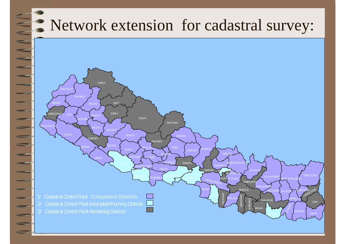
1/ Cadastral Control Point Completed Districts2/ Cadastral Control Point Incomplete/RunningDistricts3/ Cadastral Control PointRemainingDistricts
DANG
BARA
NAWALPARASICHITWAN
KAPILBASTU
KATHMANDU
Network extension for cadastral survey:

Topographic Surveys
Apart from regular production of administrative maps the department is currently involved in:
Generalization of basic topographic maps to produce maps at smaller scales viz. 1:100 000 and 1:250 000.Updating of the basic topographic maps and NTDB using remote sensing imagery has also been taken up as some of the maps are more than ten years old.Topographic surveys as and when required depending on the demand.
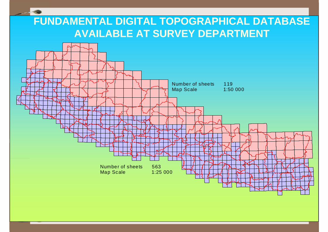
Number of sheets 563Map Scale 1:25 000
Number of sheets 119Map Scale 1:50 000
FUNDAMENTAL DIGITAL TOPOGRAPHICAL DATABASE AVAILABLE AT SURVEY DEPARTMENT
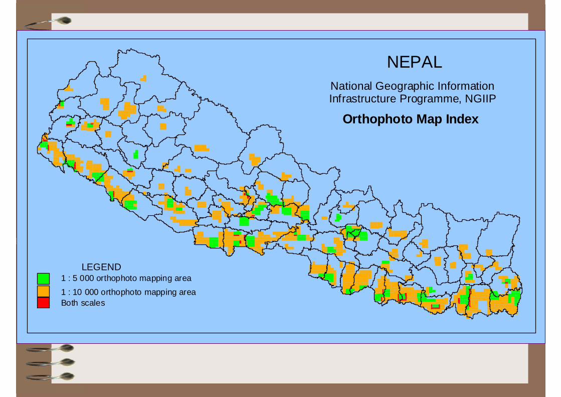
LEGEND
Both scales1 : 10 000 orthophoto mapping area1 : 5 000 orthophoto mapping area
Orthophoto Map Index
National Geographic InformationInfrastructure Programme, NGIIP
NEPAL
Cadastral Surveys• Complete cadastral surveying of the country in 1995 for
the first time - 38 districts out of 75 districts were surveyed based on local controls. Cadastral resurvey activities taken up in those districts to prepare new cadastral maps based on national geodetic control network.
• Taken up cadastral surveying in areas left out in the past such as village blocks. At present the resurveying works is being undertaken in 13 districts apart from one district where the resurvey work has been completed recently.
• In order to improve accuracy and maintenance, the department has initiated a pilot study on numerical cadastral surveying. Based on the pilot work, the methodology may be replicated in several other areas demanding precision and higher land value. This will have a great impact on the development of LIS in the country.
Digital Cadastre
• 3 wards of Banepa Municipality as Pilot Work
• Satisfactory Result
• New Work started in Tikathali and Imadol VDCs of Kathmandu District
Licensing
• The department has started issuing Licenses to the Surveyors
• 27 Licensees has been issued for the first time• Code of Conducts for the Surveyors has been
defined• The Department is currently working on the
modalities of issuing license for different category to private surveyors in order for them to participate in various land survey activities in the country.
Publications
Some of the publications apart from regular surveying and mapping products are;
• Nepalese Journal on Geo-informatics - annually.• List of Geographical Names Volume I to V, New versions
planned; Volume II, IV and V published recently.• Working manual of Cadastral Survey 2060 BS• Proceedings:
– Colloquium on the Role and Functions of Survey Department in the context of Broader Technological Development (2005 AD).
– Seminar on Space Technology Applications and Recent Developments in Geo-spatial Products (August 17, 2005).
• Socio-economic Atlas (2005 AD)• School Atlas (2001)

Mapping Committee
Mapping committee has been constituted to facilitate publishing of different mapping products and also to maintain minimum level of standards. Its main responsibilities are as follows:
• To assist various ministries, departments and organizations in the preparation of maps and provide authorizations for publication of maps.
• Store all published maps in a central repository in the Department for security purpose.
• Bring about uniformity in the mapping procedures.• Advise the government in the preparation of policy in
Mapping and related works.• Avoid duplication of mapping work; improve quality of
finished product and coordinate between different governmental organizations.

Participation in international forums
• Survey Department has participated in different international activities. It is also affiliated with several agencies.
• The department is regularly in communication with these organizations for the promotion of space technology application in Nepal either by participating in their events or by presenting its state of art of the technology.
• Published global map ver. 1 through ISCGM and in the process of publishing ver. 2.
• It also has successfully convened 23rd ACRS in 2002 in Kathmandu.

FengYunCast Geo-System
• China Meteorological Administration CMA has granted FengYunCast Geo-System User Station to Nepal
• This User Station is installed in Nagarkot Observatory in Kathmandu
• Data is yet to be received since the installation is not finalized
• The system will deliver data from meteorological satellites FY-2C and FY-2D
Steps ahead –Plans and Programmes envisioned
Apart from its regular programmes, the Department has initiated/planned several programmes, some are:
• Re-engineering of Cadastre System• National Geographic Information Infrastructure• Land Resource Information System• National Atlas Information Service

Role of Earth Observation Data in Post Conflict Nepal
• To make evidence-based policy decisions,• To facilitate in formulating need based plans,• To take precautionary initiatives to save lives
and destruction of infrastructures from natural disasters
• Ultimately, In the context of reconstruction of post-conflict Nepal, it is expected that the earth observation data could be optimally used as fundamental tool for the development activity to make it sustainable.

• Survey Department, the National Mapping Organisation of Nepal
• Land Use Project, Ministry of Land Reform and Mgmt• Department of Mines and Geology • Department of Forest • Department of Water Induced Disaster Prevention• Ministry of Agriculture and Cooperatives• Department of Hydrology and Meteorology
Metropolitan Cities / Municipalities for land resource maps• International Center for Integrated Mountaineering
Development (ICIMOD)• Many more other organisations, NGOs / INGOs
Earth Observation Data producers in Nepal
Participation in the activities of international professional organisations to introduce newer concept and technologies
Associated with FIG, GSDIA, AARS, ISCGM, PCGIAP, APRSAF, GEO and SNAC (SAARC Networking Arrangement on Cartography, Presently chaired by the Director General of Survey Department Nepal)Convened successfully 23rd ACRS in 2002 in KathmanduPublished Global Map Data of Nepal ver. 1 through ISCGM and in the process of publishing ver. 2
Efforts of Survey Department in Earth Observation Sector

Efforts of Survey Department in Earth Observation Sector…
Worked with some mini-projects supported by JAXA in Disaster Management sector.
The department is making its best effort to support the implementation of GEOSS-10 Year implementation plan

Constraints of Space Application in Nepal
Lack of sufficient allocation of budget and resources for the investment in space technology application sectorLack of proper education, research and awareness in the field of space technologyLack of proper human resources and the expertiseLack of data sharing and co-ordination policies among the organizations involving with space technology application Lack of recognized platform to develop the overall space technology to improve access, sharing, integrated and use of space data

Regional Cooperation Expected
Human Resource Development• Looking for opportunities of Advanced Trainings and Academic
Degrees in Space Technology Sector• Participation at Regional Seminars Workshops etc
Resource/Data Sharing• Establishment of Regional Spatial Data Infrastructure is
recommended• Survey Department expects its role as nodal point for one of the
region within Asia PacificDisaster Monitoring• Capacity Building for data interpretation and Use


![[SVY] Survey Data - Data Analysis and Statistical Software · Introduction to survey data manual 1 ... jfor the jth observation means, roughly speaking, that the jth observation represents](https://static.fdocuments.net/doc/165x107/5ac3ebc17f8b9af91c8c910c/svy-survey-data-data-analysis-and-statistical-software-to-survey-data-manual.jpg)