General Accessories - Hammond Enclosures and Hammond Transformers
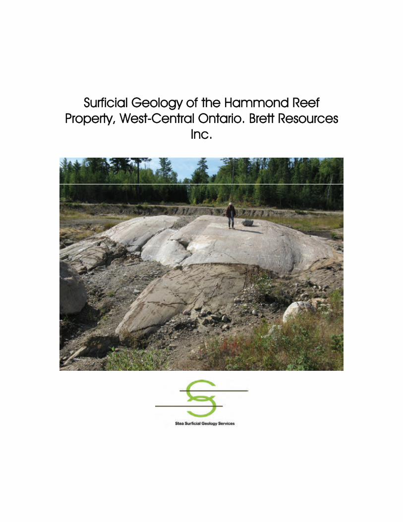
Surficial Geology of the Hammond Reef Property, West-Central Ontario. Brett Resources
Inc.
2
Surficial Geology of the Hammond Reef Property, West-Central Ontario.
Prepared for: BRETT RESOURCES INC.
SUITE 611, 675 WEST HASTINGS STREET VANCOUVER, BC CANADA V6B 1N2
By: Rudolf R Stea Ph.D P.Geo.
Stea Surficial Geology Services 851 Herring Cove Road
Halifax, Nova Scotia B3R 1Z1
October 9th , 2009

3
Summary
A surficial mapping program has been completed on the Hammond Reef Property to evaluate the efficacy of geochemical surveys in the various terrains, particularly the masking effect of thick or allocthonous sediment cover. One hundred and twenty four field stops were made over a 10 day period between September 21 and October 1, 2009 at sites delineated by air photo and LANDSAT image interpretation. The type of surficial material, grain-size variation, stratigraphy, erratic content, and extent were all documented. Four major terrain units were delineated in the Brett Resources claim groups. Covering the most area was is a unit termed Till Veneer-Discontinuous, a surface with numerous bedrock outcrops as knobs and ridges and a sporadic veneer of glacial till. Till cover is usually greatest in hollows between bedrock highs, but rarely exceeds 2m in total. In a broad shallow trough occupied by Marmion Lake bedrock is intensely scoured and Pleistocene sediment is sparse or absent, excepting occasional deposits of sand and gravel. The unit is termed Scoured Bedrock. Waterlain deposits (Outwash Delta) form another significant landscape unit generally located in topographic lows or broad troughs feeding into the heads of Sawbill Bay and Finlayson Lake. In many areas the surface sediment is medium to coarse sand but near the margin of these troughs coarse, bouldery sand and gravel is featured as the surface deposit. Organic peat deposits form the last major terrain unit and consist of various depths of peat and muck in bogs, swamps, fens and marshes. During the peak of the last glaciation ice flow was southwestward across the Property. This later changed to a southward flow during the Rainy Phase. Regional deglaciation was punctuated by stillstands or minor readvances of the Laurentide ice front that resulted in the formation of large, arcuate, recessional moraines in the area termed Eagle-Lake-Finlayson Moraine and the Steep Rock Moraines. Further ice recession to the head of Marmion Lake resulted in the formation of ice contact deltas into Lake Agassiz, but no recognizable moraines. The terrain unit designated as Till Veneer features thin, locally-derived till and bedrock outcrop and as such provides the best substrate for detailed soil and rock geochemical surveys. Soils are either derived directly from weathered bedrock (residual) or from glacial till, a “first derivative” of bedrock. Areas mapped as outwash deltas (glaciofluvial sediments) in the northern part of the Property provide a special challenge in utilizing traditional soil surveys because these sediments contain little local bedrock and can be up to 10m thick. Local variability in every terrain on the Hammond Reef Property will often produce noisy soil data. Partial extraction techniques such as the Enzyme LeachSM method may provide greater anomaly/background contrast and can detect buried mineralized sources. Reconnaissance exploration on the claim groups may be best accomplished using glacial till sampling and heavy mineral analyses.

4
Table of Contents
Summary............................................................................................................................ 3 Table of Contents .............................................................................................................. 4 Introduction....................................................................................................................... 5 Methods.............................................................................................................................. 6 Results ................................................................................................................................ 8
Terrain Units ................................................................................................................... 9 Scoured Bedrock......................................................................................................... 9 Till Veneer-Discontinuous........................................................................................ 10 Outwash Deltas and Meltwater Channels ................................................................. 10 Organic Terrain (Muskeg) ........................................................................................ 14 Disturbed Ground...................................................................................................... 14
Patterns of Ice Flow ...................................................................................................... 14 Quaternary Events.......................................................................................................... 15 Implications for Mineral Prospecting and Recommendations ................................... 18 References ........................................................................................................................ 20 Front Photo: Roche Moutonnées or whaleback ice sculpted form on the Reef Road. In the foreground on the outcrop is altered granite, with weathered sulphide bands along fractures. Acknowledgements: The author would like to thank Zoran Madon , exploration manager, Brett Resources for helpful discussions in the field, Andy Bacj of the Ontario Geological Survey for some tips on local surficial geology, and Eric for tireless assistance in the field.

5
Introduction Stea Surficial Geology Services was contracted by Brett Resources Inc. to map the surficial geology of the Hammond Reef Property and associated claims near Atikokan Ontario. The purpose of this mapping program was defined by Zoran Madon, senior exploration manager: “For the most part, we believe that the Hammond Reef area is covered with a thin veneer of till that, if sampled properly, would be able to provide us with real targets for follow-up work (either stripping or drilling). If that is not the case (i.e. if there are other types of glacio-fluvial or glacio-lacustrine deposits that are masking a buried zone of Au mineralization), then we need to know and to modify our geochemical sampling techniques for those areas.” Given this background the purposes of this surficial mapping program can be stated as follows: 1. Mapping surficial materials and terrains on the Hammond Reef Property and evaluation of the efficacy of geochemical surveys in the various terrains, particularly the masking effect of thick or allocthonous sediment cover. 2. Assessment of the flow directions of glaciers in the area, with the goal of determining source areas of mineralized float on the Property. The area is part of a Precambrian peneplane with elevations ranging from350m to 500m with northward drainage into Hudson’s Bay from the regional divide east of the claim groups (Fig. 1). The topography is generally bedrock controlled but much of the terrain fabric has been enhanced by glacier flow A prominent northeast-southwest terrain fabric can be seen on the regional digital terrain model (Fig. 1), parallel to known faults in the region as well as the main southwest glacial flow direction (Zoltai, 1965; Bajc, 2001). Also important are deep, broad troughs of the same orientation, represented by the major lakes in the area which have been interpreted as meltwater spillways. Also of note for this report, is a subtle north-south terrain fabric which may be largely of glacial origin. Prominent NW-SE trending ridges in the southern part of the claims areas are the Eagle-Finlayson and Steep Rock Moraines (Fig. 1). The main Hammond Reef Property lies within the early Precambrian Marmion Lake Batholith near its western margin (Fig. 2). This batholith is a multi-phase intrusion varying in composition from quartz diorite (tonalite) to granite. The western margin of the batholith is a geologically and structurally complex area. Rafted sheets and blocks of gneissic basement rocks and mafic metavolcanic rocks are relatively common in this area. Gold mineralization has been documented in the Marmion Lake Batholith since the late 1800's (Wilkinson, 1982). The gold mineralization is related to quartz veining and disseminated pyrite within shear zones or breccia zones .

6
Figure 1. NASA SRTM DEM with location of the Hammond Reef Property (star) and Brett Resources Inc. claim groups.
Methods
Air photograph reconnaissance was conducted prior and post field data acquisition utilising photos at scales of 1:15,000 and 1:50,000. An Old Delft Scanning Stereoscope was used for this purpose. The smaller scale colour photos were made available by Brett Resources and black and white 1:50,000 air photographs were obtained from the National Air Photo Library in Ottawa. Prior to the field work a regional study of lineations in the claim group areas was completed using Landsat 7 (band 8) imagery obtained from the GEOGRATIS web site: (http://geogratis.cgdi.gc.ca/clf/en). A regional digital terrain model (DEM) was (Fig. 1) created from elevation data obtained from NASA’s Shuttle Radar Topography Mission (SRTM-http://dds.cr.usgs.gov/srtm/version2_1/SRTM3/North_America/). These data are available on a near-global scale and provide the most complete high-resolution digital topographic database of Earth.
Glacial flow at both large and small scales tends to produce linear, flow-parallel landforms. These flow-parallel features were mapped.

7
Figure 2. Bedrock geology of the Hammond Reef Property.
1. Glacial “megagrooves”. Large furrows most readily seen in regions of thin till cover and bedrock, 10 to 60 m wide and 0.5-23 km long (e.g. Clark, 1993). The sense of flow of these features (which way?) can be determined by widening and truncation down-ice (as in the analogous small-scale erosional features known as nailheads and wedge-striae (Prest, 1983) and in preferential scouring on up-glacier facing slopes. In some cases megagrooves are glacially enhanced bedrock structure, where joint or fault traces, parallel or sub-parallel to glacial flow, are selectively eroded. There may be some question about cause and effect, considering that the sliding glacier bed can be influenced by pre-existing bedrock topography even at a small scale.
2. Drumlins and stoss/lee bedrock forms (roches moutonnées). Drumlins are streamlined hills with a steep up-glacier facing side and a tapered

8
down-glacier side (Benn and Evans, 1998; Fig. 3). Stoss/lee bedrock forms (roches moutonnées) are asymmetric bedrock hills with abraded, smoothed up-ice or stoss faces and steep, quarried down-ice lee faces.
3. Glacial striae. Parallel, linear scratches on rock surfaces. In some cases two or three “sets” or striae can be observed on outcrop and relative ages can be determined based on the set which exists or is most prevalent on the uppermost surfaces of the rock microtopography.
One hundred and twenty four field stops were made over a 10 day period at sites delineated by air photo interpretation. The type of surficial material, grain-size variation, stratigraphy, erratic content, and extent were all documented. Photographs were taken at each site. Sixteen 10 kg samples were taken at selected locations of both till and glaciofluvial/glaciolacustrine sediments. These samples were taken to quantitatively assess the properties of the sediments including grain size and lithology, but most importantly, to investigate the heavy mineral fraction for economic mineral content. Several samples were obtained from tills near and down-ice of the main Hammond Reef showing (Map 1) as a check that local mineralization is represented in till samples and to assess what mineral types may be best suited for regional exploration. In addition, samples taken regionally will be used to assess the fidelity of glaciofluvial sediments to local bedrock and evaluate regional patterns of mineral dispersal. At the time of writing sample data is not available, so an addendum to this report will be produced. These samples will be processed for free gold content by Overburden Drilling Management Limited in Ottawa Ontario (ODM) as well as a suite of accessory heavy minerals associated with the Hammond Reef deposit including pyrite, chalcopyrite, galena, magnetite, hematite, ilmenite and pyrrhotite. Field stops and samples were fully documented with photographs and the data input into GIS (ARCVIEW 3.3) project. Interpreted air photographs were scanned and georeferenced into the GIS project and surficial contacts digitized from these photos. A colour map was produced (Map 1) at a 1:50,000 scale from the polygon shapefile databases created from these data.
Results What is most striking about this region is the abundance of outcrop. This can be ideal for prospecting, geochemical and geophysical surveys. Outcrop is nevertheless obscured in many areas by plant growth, peat, moss and lichen cover, till veneer and glaciofluvial sediment cover. In some cases this cover is substantial. Pleistocene sediment cover is too thin to allow for a lithostratigraphic classification so the terrain classification is based largely on morphology and type of sediment cover patterned after the morphostratigraphic concept developed by Willman and Frye (1970) and the glacial-morphological classification scheme of. Goldthwait (1989). A morphostratigraphic unit

9
Figure 3. Rock drumlins (yellow arrow indicated ice flow direction) north of Sawbill Bay (Map 1).
is defined as a body of rock that is identified on the basis of surface form (Willman and Frye, 1970). The engineering terrain unit land classification scheme used by Mollard (1980) for the region is very similar. As is stratigraphic practise, units are arranged from oldest to youngest in terms of when the timing of processes that created the landforms.
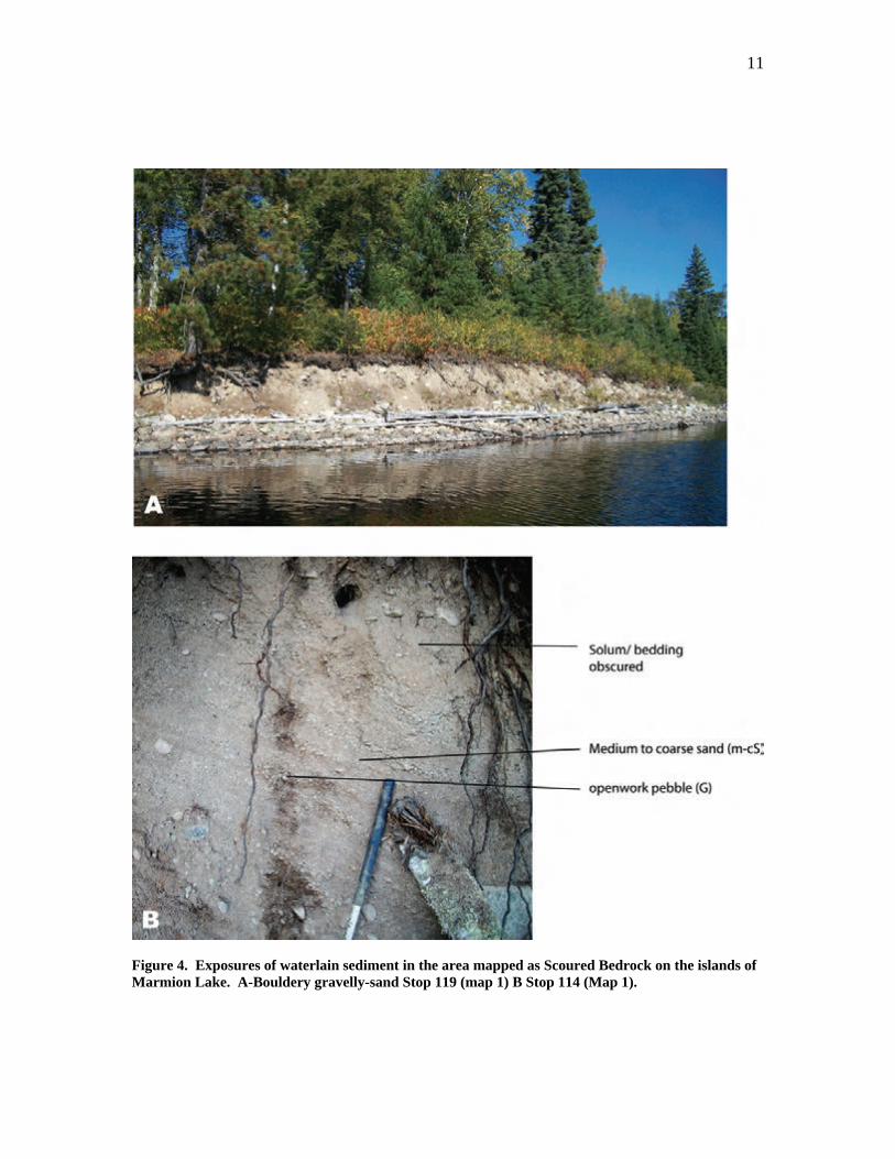
Terrain Units Scoured Bedrock Bedrock outcrop is ubiquitous throughout all the areas staked by Brett Resources. Areas of outcop, however, are particularly numerous in a corridor between Finlayson lake and the Seine River encompassing all of the islands in Marmion Lake (Map 1). In these regions bedrock is intensely scoured and Pleistocene sediment is sparse or absent. The terrain consists of bedrock knobs, weathered in higher elevations and covered with moss and lichen and at lake level, linearly scoured by ice action (Map 1) and formed in classic stoss and lee shapes of glacier erosion (front photo). Outcrops of till are absent at least at lake level in Marmion Lake The few outcrops of sediment observed in the region were invariably waterlain sediment, specifically coarse bouldery gravelly-sand and parallel-laminated, graded beds of openwork gravels and sand. These sections were generally found at water level, and were not more then 2m thick (Fig. 4). A single till covered site was found at a higher elevation on an island in the southern part of Marmion Lake (Map 1). The lack of till outcrop at lake level may suggest elevation control to some of the scouring.

10
Till Veneer-Discontinuous The main landform-terrain unit of the study area is a surface with numerous outcrops as knobs and ridges and a discontinuous veneer of glacial till. Till cover is usually greatest in hollows between bedrock highs (Fig. 5b), but rarely exceeds 2m in total thickness. Notable in their absence are depositional landforms made up solely of till. The percentage of bedrock outcrop in any area varies widely from 10-80%. Topographic lows are often sites of perched water tables, and peat formation. Topography is controlled primarily by bedrock structure, although some linear features may be enhanced by glacier erosion. Symmetrical, streamlined landforms with an inverted spoon shape called drumlins (Fig. 3) were common in the terrain, and were initially believed to be composed of glacial till like drumlins in other areas (Goldthwait, 1989). It was observed, however, that the features in the region were composed primarily of rock and as such are termed rock drumlins (Benn and Evans, 1998). Till within the region is divisible into two units or facies. The lower unit, (Unit 1) is a stony, sandy diamicton (unsorted mixture of gravel/sand/mud) with significant silt in the matrix and locally-derived granitoid clasts. In some exposures the till was compacted. Unit 1 till can also exhibit a crude lamination with matrix-dominated zones and bouldery layers. An upper unit (Unit 2) found in many areas is characterized by a diamicton with high boulder content, a sandy matrix and some sorted, waterlain layers (Fig. 5a). Erratic lithologies are common particularly pink, potash-feldspar granitoids and mafic rocks, derived from regions northeast of the claim groups (Fig. 2). The type sections for this package of till facies were found along the Rab Bay trail (Stops 21, 22; Map 1). Outwash Deltas and Meltwater Channels Waterlain deposits form a significant and important landscape unit north of Sawbill Bay (Map 1). The deposits are generally located in topographic lows or broad troughs feeding into the heads of Sawbill Bay and Finlayson Lake. In many areas the surface sediment is medium to coarse sand but areas near the margin of these troughs feature coarse, bouldery sand and gravel as the surface deposit. Exposures of the waterlain sediment at several localities in the claims areas (Stops 14, 55; Map 1) exhibit a similar stratigraphic sequence. A massive bouldery-gravelly sand unit overlies fine-grained sediment. The coarse facies varied in thickness from 1-2m, and formed cut and fill bodies over the lower facies (Fig. 6b). Boulders are mostly well-rounded, and consist of local and distal rock types. The lower sediment facies consists of alternating parallel-laminated, normally-graded, medium to coarse sand beds, overlain by fine-sand or silt beds, sometimes with ripple laminations (Fig. 6c). A subaqueous origin is postulated for this lower fine-grained sediment assemblage.
11
Figure 4. Exposures of waterlain sediment in the area mapped as Scoured Bedrock on the islands of Marmion Lake. A-Bouldery gravelly-sand Stop 119 (map 1) B Stop 114 (Map 1).

12
Figure 5. Exposures of glacial till in the area mapped as Till Veneer-Discontinuous along the Rab Zone trail. A-Stop 21-Map 1 B-Stop 22-Map 1.

13
Figure 6. Deposits mapped as Outwash Delta, north of Sawbill Bay. A Stop 14-Map 1 B. Stop 55-Map 1. Note the large boulder content in the high energy upper facies.

14
The lower facies are interpreted as deltaic foresets as they are observed at several outcrops to dip to the west and northwest at about 10 degrees. The surface form of these deposits was not readily apparent because of gravel extraction. Much of the sandy sediment within the troughs may be ice-proximal foreset or bottomset beds. The coarse sediment on top is interpreted as delta topsets, but the widespread occurrence of this unit in regions far to the south, suggests that the sediments were part of a widespread jökulhlaup (flood) event that occurred after the breaching of an ice dam, and was, in part, responsible for the formation of the Scoured Bedrock unit. To the south of the exposures of deltaic and glaciofluvial sediments are numerous sinuous valleys channels 50-100m wide and 500m-1km long, interpreted as meltwater channels (Map 1). In one such channel (Stop 70; Map 1) there was observed a bedrock surface, smoothed and pitted, without glacial striae, the only such outcrop observed in the field area. Organic Terrain (Muskeg) Organic Terrain consists of various depths of peat and muck in bogs, swamps, fens and marshes. The terrain can be covered by sedge and sphagnum peatland vegetation or stunted black spruce and is easily identified on air photographs. Stratigraphy in these areas can vary from a thin veneer of peat over bedrock to several metres of peat overlying fine-grained sediments or till. A typical bog in the study area is surrounded by bedrock knobs. Disturbed Ground North of Atikokan on the southeast portion of the map area is the former open pit Steep Rock Iron Mine which is easily identifiable on the air photographs and on the digital terrain model (Fig. 1), as an unusually deep depression. This huge open pit mine is an obvious example of a disturbed landscape, but all roads on the map sheet can be considered as part of this unit. In addition areas of trenches and former workings on the Hammond Reef Property are examples of disturbed ground. These are at a scale too small for the present mapping, but should be considered when designing geochemical surveys.
Patterns of Ice Flow
Ice flow directions on the map sheet are defined by the orientations of megagrooves, rock drumlins and glacier striae (Map1; Fig. 7), all of which define glacier ice flow to the south and southwest between 225˚ and 180˚. Flow variation within this azimuthal grouping is not merely due to topographic streaming (Boulton, 1974) but a result of several temporally distinct glacier advances or “phases” as defined by Zoltai (1965). The bimodal distribution of drumlin orientations, with both southward and southwestward peaks, represents one line of evidence for distinct “phases” of ice flow (Fig. 7). A type location on the Hammond Reef Property on the Reef Road (Stop 38;

15
Figure 7. Orientations of glacial striae and rock drumlins on the Hammond Reef Property. The probability sector represents the most probable up-ice source areas of mineralized boulders and till anomalies. Map 1) revealed two distinct superimposed sets of glacial striae with the older set at 215˚and a younger set at 190˚ (Fig. 8). The southward-trending set is definitively younger because it is inscribed on the uppermost surfaces of bedrock surface undulations initially formed by the earlier event (Stea, 1994; Fig. 8). The main flow event in the region appears to be a strong southwestward flow between 200˚ and 220˚ but at several localities there are crossing striation sets within this azimuthal grouping.
Quaternary Events
The erosional and depositional features preserved within the study area record a complex history of ice flow events associated with the Wisconsinan glaciation (Zoltai, 1965; Bajc, 2001). The earliest and most prevalent ice flow in the region is southwestward "northern" (Laurentide) ice during the Wisconsinan glaciation. Striae associated with this event generally range between 200° and 220° and are recorded south of the map area as far as the US border (Prest et. al., 1968). It is presumed that this southwestward ice merged with ice flowing southeastward at the glacial maximum terminating at the Bemis Moraine of the Des Moines Lobe in Iowa (Denton and Hughes, 1981). This regional southwestward ice flow was superseded by a southward flow termed the Rainy Phase or Rainy Lobe perhaps terminating at the Alexandria Moraine in Minnesota (Patterson and Johnson, 2004)

16
Figure 8. A. Two sets of crossing striae on metasediment outcrop near the Reef Road. B-close-up 1. 215˚(compass) 2. 190˚(pen) Stop 38-Map1.

17
Figure 9. A- regional ice flows during the Late Wisconsinan maximum and early recession. B- Ice retreat positions of the Laurentide Ice Sheet. Possible flood routes (yellow arrows)

18
Regional deglaciation was punctuated by stillstands and minor readvances of the Laurentide ice front that resulted in the formation of large, arcuate, recessional moraines in northwestern Ontario (Figs. 1; 9; Map 1). In the Hammond Reef Property area these include the Eagle-Lake-Finlayson Moraine and the Steep Rock Moraines. The Finlayson Moraine was formed as Laurentide ice dammed up Lake Agassiz (Zoltai, 1965; Bajc, 2001). Further ice recession to the head of Marmion Lake resulted in the formation of ice contact deltas into Lake Agassiz, but no recognizable moraines. A sudden drop in the level of Lake Agassiz during the retreat of ice out of the Superior Basin, may have resulted in a flood event that accounts for boulder gravels and the scouring of bedrock throughout the Marmion Lake trough.
Implications for Mineral Prospecting and Recommendations
The type of prospecting or geochemical survey required for an area depends largely on the scope of the survey, whether reconnaissance or detailed, and to some extent the two types use different materials for sampling and analysis. Levinson (1974) defines detailed surveys as “carried out with the objective of locating exactly as possible individual mineral deposits or indications of structures where these deposits may occur”. On the other hand reconnaissance surveys are designed to evaluate large areas of favorable geology with the specific goals of delineating areas for detailed work, or eliminating barren ground. Sampling media such as soils and rock are characterized by limited dispersion haloes around their mineralized host rock, and are more suited for detailed work, whereas streams and tills (boulders-float) with greater secondary dispersion provide larger targets for regional exploration. On the Hammond Reef Property as stated in the introduction, it is clear that the company is conducting detailed surveys and as such soil and rock geochemical surveys provide the best sampling media. The terrain unit designated as till veneer (Map 1) features thin, locally-derived till and bedrock outcrop and as such provides the best substrate for these types of detailed surveys. Soils are either derived directly from weathered bedrock (residual) or a derived from glacial till, a “first derivative” of bedrock (Shilts, 1976). Some problems, however, may be encountered when till thicknesses increase and sandy, ablation tills are deposited. This till facies has a more distant provenance and may dilute or mask local anomalous bedrock. The results of our till sampling on the Property will provide the data necessary to evaluate if these tills effectively represent local bedrock. It is unclear how much ablation till is present on the Property, as it has been found at only a few locations. Unmapped small pockets of organic peat may also mask anomalies. The large area of scoured bedrock in the trough of Marmion Lake in many respects is similar to the region of till veneer, dominated by exposed bedrock. It is estimated that ~ 10 percent of the bedrock may be covered by waterlain sediments that may effectively mask a local bedrock signature. The abundance of outcrop, however, and residual soils in the higher elevations should allow for similar prospecting approaches as in the till veneered areas.

19
Areas mapped as outwash deltas (glaciofluvial sediments) in the northern part of the Property provide a special challenge in utilizing soil surveys for prospecting on a detailed or reconnaissance scale. These sediments can exceed 10m in thickness, and are largely allocthonous. Outcrop is not abundant in these valleys. Using traditional soil geochemical sampling and aqua-regia digestion, prior to analyses is likely to produce erratic results at best because local bedrock content may be minimal. If a promising structure can be traced under this sediment cover, other approaches may be warranted including trenching, basal till sampling or partial extraction soil techniques. It must be noted that these waterlain sediments may be more extensive than mapped given the short time frame of field work, and every low-lying region north of Sawbill Bay (Map 1) may have some waterlain cover especially if the area was inundated by Glacial Lake Agassiz. . B-horizon soils are not present in areas mapped as organic terrain and so the samples must be treated separately from podzol-type soils. Peat sampling in bogs near mineralized bodies has produced elevated metal levels compared with bogs outside mineralized zones (Levinson, 1974). In some cases however, false anomalies have been produced by spurious metal enrichment. The results are likely to be erratic because of varying zones of metal enrichment within the bog sediment profile. Certainly bog samples and b-horizon soils should be classified separately before determining background and threshold metal levels. Noisy soil data may be a problem in every terrain on the Hammond Reef Property due to variability in substrates. In some areas thick sediment cover (organic/outwash) over mineralized bedrock can completely mask a geochemical response from soils analyzed for bulk metal content. An alternative approach may be the use of partial extraction techniques such as the the Enzyme LeachSM (EL) method (Clark, 1993). The EL method was designed to detect cation and anion migration in the surficial environment resulting from oxidation of these buried ore bodies. Case-studies in both temperate and tropical regimes have demonstrated the capacity of EL to delineate orebodies concealed by glacial drift or bedrock cover up to hundreds of metres thick (e.g. Bajc, 1998; Yeager et al., 1998). The method utilizes an enzyme-catalyzed reaction which dissolves manganese oxides (Clark, 1993) from b-horizon soils. These hydrous oxide complexes are capable of scavenging trace elements in high concentrations relative to the bulk soil matrix, and thus often produce robust anomaly to background responses to mineralization. The species adsorbed may include dissolved and vapour phases, possibly diffused from considerable depths beneath both surficial and bedrock cover. Critical to the method is the differentiation of discrete halo (oxidation-type- rabbit-ear anomalies adjacent to the ore body) and apical (directly above the ore body) anomaly forms which are, by definition, antithetic. Oxidation halos, typically incorporating halogens (Cl, Br, I) and elements with a propensity for the formation of volatile halides (e.g. As, Sb, Mo,W, Re, Se, Te, V, U, Th) are believed to be the product of ion migration within electrochemical cells developed above any reducing subsurface body (e.g. sulphide deposit; Clark and Russ, 1991; Williams and Gunn, 2002). Apical anomalies are related to vertical diffusion from a highly concentrated source and, in contrast to oxidation anomalies, generally display some compositional affinity to the orebody (Williams and Gunn, 2002).

20
The discussion so far has centered on detailed surveys, but Brett Resources may also wish to evaluate large areas of property on a reconnaissance scale. Till and glaciofluvial sediment samples from the Property sent to ODM will provide the data necessary to evaluate these local media as reconnaissance sampling tools for the Hammond Reef-type deposits. Bajc (2001) reported that both gold and sulphides were picked up during regional till sampling to the east of the Hammond Property emanating from various types of shield mineral deposits. The ice flow data presented in this study will allow for determination of possible source areas of anomalies found in the sampled tills, as well as any float finds (mineralized boulders) made subsequent to this study. The compilation of ice flow indicators for the Property allows for construction of a “probability sector” which is the up-ice target region for the mineralized source of dispersed boulders and till anomalies (Hirvas and Nenonen, 1990; Fig. 7).
References
Bajc, A.F., 1998. A comparative analysis of enzyme leach and mobile metal ion selective extractions: case-studies from glaciated terrain, northern Ontario; Journal of Geochemical Exploration, v. 61, p. 113–148. Bajc, A.F. and Crabtree, D.C. 2001. Results of regional till sampling for kimberlite and base metal indicator minerals, Shebandowan greenstone belt, northwestern Ontario; Ontario Geological Survey, Open File Report 6046, 64p. Benn, D.I., and Evans, D.J.A., 1998. Glaciers and glaciation; Arnold, London 734p. Boulton, G.S., 1974. Processes and patterns of glacial erosion; in Glacial Geomorphology ed. Clark, C. D., State University of New York, p. 41-87. Clark, C.D., 1993. Mega-scale glacial lineations and cross-cutting ice-flow landforms; Earth Surface Processes and Landforms, 18, pp. 1–29. Clark, J.R., 1993. Enzyme-induced leaching of B-horizon soils for mineral exploration in areas of glacial overburden; Transactions of the Institute of Mining and Metallurgy; v. 102, p. 19–29 Clark, J.R. and Russ, G.P., 1991. A new enzyme partial leach enhances anomalies in pediment soils near buried gold deposits; 15th International Geochemical Exploration Symposium, Association of Exploration. Geochemists; Reno, NV, 29 April–1 May 1991 Denton, G.H., and Hughes, T.J., 1981.The last great ice sheets, John Wiley and Sons, Inc., Toronto, Ontario, 484p

21
Goldthwait, R.P., 1989. Classification of glacial morphologic features; in Genetic Classification of Glacigenic Deposits, Goldthwait. R.P. and Matsch, C.L. (eds), Balkema Rotterdam, p. 267-278. Hirvas, H. and Nenonen, K. 1990. Field methods for glacial indicator tracing; in: Glacial Indicator Tracing, R. Kujansuu and M. Saarnisto, (eds.), Balkema, Rotterdam, p. 217-247. Levinson, A.A., 1974. Introduction to Exploration Geochemistry; Applied Publishing Ltd., Wilmette, Illinois, 614p. Mollard, D.G., 1980. Northern Ontario Engineering Terrain Study; Data Base Map, Marmion Lake, Ontario Geological Survey Map 5073, Scale: 1:100,000. Patterson, C.J., and Johnson, M., 2004, The status of glacial mapping in Minnesota; in Quaternary Glaciations Extent and Chronology, Part II North America, Ehlers, J., and Gibbard, P. L., (eds.) Elsevier, p. 213-232. Prest, V.K., Grant, D.R., and Rampton, V.N., 1968. The Glacial Map of Canada, Geological Survey of Canada, Map 1253A Scale- 1:5,000,000. Prest, V.K., 1983. Canada's heritage of glacial features, Geological Survey of Canada Miscellaneous Report 28, Ottawa, Ontario. Shilts, W.W., 1976. Glacial till and mineral exploration; in. Glacial Till: An Interdisciplinary Study.. Leggett, R.F., (ed) Royal Society of Canada, Special Publication No. 12, p. 205-224. Stea, R.R. 1994. Relict and palimpsest glacial landforms in Nova Scotia, Canada; in Formation and Deformation of Glacial Deposits. Warren, W. P. and Groot, D. G. (eds.) Balkema, Rotterdam, p. 141-158. Wilkinson, S.J., 1982. Gold Deposits of the Atikokan Area; Ontario Geological Survey, Mineral Deposits Circular 24, 54p. Williams, T.M. and Gunn, A.G., 2002. Application of enzyme leach soil analysis for epithermal gold exploration in the Andes of Ecuador; Applied Geochemistry, v. 17, p. 367–385. Willman, H.B., and Frye, J.C., 1970. Pleistocene Stratigraphy of Illinois, Illinois State Geological Survey Bulletin 94, Urbana, Illinois, 203p. Yeager, J.R., Clark, R.J., Mitchell, W., Renshaw, R., 1998. Enzyme leach anomalies associated with deep Mississippi Valley type zinc ore bodies at the Elmwood Mine, Tennessee; Journal of Geochemical Exploration, v. 61, p. 103–113.

22
Zoltai, S.C. 1965. Glacial features of the Quetico-Nipigon area, Ontario; Canadian Journal of Earth Sciences, v.2, p.247-269.

����
���
�
�
����
�
�
�
�
��
�
�
�
�
�
�
� � ��
��
�
��
�������� �
�
�
�
�
�� �
� �
� �� ��
� �
��
��
�
�
�
��
��
��
��
�
��
���
�
�
� �
�
���
��
��
�
�
�
��
�
��
�
� � � �
�
��
�
�
�
�
�
�
��
�
�
�
�
�
�
�
�
��
�
�
�
�� �
�
�
��
� � ��
�� � � �
��
�
�
� ��
� ��
��� � �
� � ���
���
� ���
� �� �
� ��
� �� ���
� �����
�����
��
��
��
�
� � � �
� ��
��� ��
�
�� � � � ��
�� � � � � � ��
�� ��� �
� � ��
� �
��
� �
� �� �
�� �
� ��
�
��
� � � �� �� � �� ��
�� �
�
� �
� �
� �
� �
�
�
�
�
�
��
� �
� �
��
�� � �
�
��
�
�
��
�����
��� � � �
�
� �
���
�
�
��
�
���
�
���
���
���
���
�
��
���
�
���
�
� �
�������������������� �������
��������������������
������������
��������������
�����
��������
������������������
�����
������
�����
�����
������
����
����
���!�!�
�����
�����
���"�
�!���
�!����
��"���
#
$�"�
�!��%
�%�&�
������
�����
���'�
�����
�� ���
�����
����
�(��&
�'�!�
����%
���"
)���%
� �"�
*�+��
�����
�")�
�%� �
"����
�����
�����'
�����
%����
����!�
�")���
�(���
�����
�����
����
����
����&�
�%!���
��� �'
�,��"
����
�����
�����
�����
�(���
�"���
�� ���
������
")*��-
.,��
%���
�� �!�
����
�����
����'
�����
�!���
��,�
�����
&�����"
�!���
����%
��/
%��%
���"�
����
���*�0
�"���
����
�")��
��"�
���"�
�����
���
�,��
��"���
�����
!%���
������
��)�
�����!
��")&�
�.�!�
"���
�(���
��,�
��!�&�
�%!�%
,�"�
�����
����1
�����
���"
)���
%�"�
�����
������
!�"!��
�%����
���� !�
,���
,�"!�
���
��!��
��*�
2%!'
����3
��!��
������
��!'�
!���4
����
�����
���,
���!�
�� ���
�����
�����
(��� �
����
������
�"���
����!
'�!��
�!���
�����
,!����
!�����
"������
)��#*
���
�����
�����
(����
�,��
�!����
�� �%
�����
�����
��(���
���
�!�!��
�����
�� ��
����
�����
������
����
��0�)
��*�
+��")
����
���(�
���'�
�����
����
5��
�!����
���!�
����
�����
����
")���
��.,�
�����
,���
��"���
�*�+�
�����
�,��
�!�"�
����!
�� ��%
��/%
��%�
�����
,���!
��&�,
�����
�����
���!��
&��
����
�����
�� �"�
����
6 �����
�����
����,
��'
��)��
��(�
���(
�����
������
�%���
��&���
�(���
��,�
��!�*�
3�,�
��!���
���
"���
�����
����!�
����
!���!�
����"
����
"���,
���,
�"!��
����
"�%�
��� �
��!�
�(���
����
�!����
�����%
!�����
���"
�����
���"
)�����
�!%��
*�����
����,
���!�
�����,
����
����
����
��.!��
��(��!
�����
�,,�
�*
+����7
����
�3��"
��!��
%�%�
��%
����
!�����
,���!
��� ��
�%���
��6��
�(��6
�%���
�,��
�!���
����"
!�����
������
"���8�
����
�� �"��
�� ��
�����
�����
�����
����"
���&�
����!
���� �
"����
����
����
������
������
�!����
"�#��
9���
�")��
%!"��
,���!�
��,��
����'
�!����
,���!
��� �!
���&�
��
�:��%
!"��,
*�+�,
����
,���"
��!��
������
�����
��")
*+��
�������
(�����
����!�
�!'��
�"���
��;��!
����
�!���
���&�
��"���
����
��(��
�����
�� �"��
�8�;�
�!����9
�%���
�����
���
����!
���� �
"����'
�!����
�����
��!�"
�"��!�
�!*�+
����
�����
�%�!�
���� �
��,��
�,�"
!�����
�����
�"��
��"�
�6���
,���
�"���
�%�(�
�����
���"�
�����
��")
������
!�����
!��%�
�"���
��'�!�
����
&��%�
������
�����"
�����
���(�
��!���*
�����
����
����!�
��!��
�� ��
����,
����*�
2""�
�����
����,
���!�
�� �!�
�")���
��!���
!�����
����
��)��
�"���
����
�")*
�"�%
����9
����
")��
����
��")
��"�%
�����
���"�
������
��!'�
!����"
!���&�
�����
��!
����
(��#
9���
�")��
%!"��
,�����
���6�
�%���
��"�(
����
��%!"�
�,&�
��(�
���� �
�����
��!�"
�(��
*�2%!"
��,�
���%
������
���"�
��"
!����'
�!��%�
�/%�!�
%���!
���!��
�����
�����
�(��
*�<�!�
������
��%��
���&�
���(
�����
�����
��'��
��!��
������
�����
��!�
�%��
�����.
,��%
����!
���%
���%
!����
����
�0�)�
*�$�,�
����
� ���!
����
����!
'�!��
� ��'�
�����
������
�����"
�!����
����
���"
"�%�
!� ��
�!����
�")��
����
����
!�"�(
��*�+
����
����%
�!����
� ���
,���
,�"!�
�����
"�%�
�����
��")
����%�
�/%�!�
%�*��
�����
�����
��!���
������
���!*
�
;��(�
�����+
����
(����
����
"�!��
=��!�
�$��
��"��
�3�!%
���
��
�%� �
"����>
�����
��� �!
����
����
���?
�� �@
��,�
�!���9
��!!�?
���%
�"���A
�"*#
��
B�
����!�
��
�"���
����
&���
2���
��"�+
����
����
���,
���!�
�� �,�
�!����
����'
������
����
�� ���
���
'�!��
�!����
#$�
����'
����
�,��!�
�����
%")��
�����
��!��
�!���
��
&�"��
�!�!%!
������
�����
���%�
)��&�
��'
�����
� ����
,�����
��,��
!�%��
�����
������
���#
�����
��)���
����
��'��
,�*��
���� �"
��!��
�!���
��!�!�
��.
,����
!�����
%��!�
����
)�����
�"!�
� �!��
")�
����
��"��
�!����
�����
�"���
!�����
� ���
�����
�����
����
��,%�
��%��"
��"�
�!��!�
����
���!�
��*
3��!%
����
�>��
%����
�!����
������
�� �"�
�!����
��� ��
�����
���%�
!������
"!�(�!
�����
����6
����
!��#*�
�
$���
��� ���
�%�!�
�����"
!�(�!�
�'�!�
�����
� �"��
!���!�
��"�
�!���
��!��
��%��
%�!��
��� ��
����"
����
"��
�%�(�
��*
?�")
�3�%
�����
���")
"���
�������
�!���
�����
������
��"���
�����
���&��
���'�
����"�
!����"
�� ��'
�����
"!���
*�
����
���*
>��"
�����
!���!��
������
�����"
���"��
!"���
������
")&��
�����
���"�
!����"
�� ��'
�����
"!���
*
���!'
�!���4
����
�����!
��,��
����&�
���%�
%��"�
����
��"%!�
�����
�"���
����!
'�!��
*
�
�!�%
"!%��
��0���
����
!���!��)
������
�6 �%
�!6"��
!�"!���
����
� ��!%
�����
�0$=3
�$+�
�����
���,��
!����
,��*�
>��"
����0�
����
��!��C
����
����
(�C��
����
��"���
����"
����!�
�%��
��(���
������
�0$=3
�$+�
����
���*
������
�!�,
�0�"�
!�����
���!�
,����
"!���
�����
���,�
�!#
>��"
�����
�"�%
�����
����!
�����
��")
&����
����
�0�)�
+����(
����
���(�
�����
��")
&�'�!�
�����!
������
�����
��� �"
���*�
>��"
������
�!�� �
����
!����
��'�!�
��(��
�����
���%��
�����
%!'��
�*�
+�,�"
�����
�6'�!�
����
���)�
������
����
")�)�
���*
�����
��'����
�9��
����
����0�
)�
������
����0�
)�
��')
�9��
!"#"""
!"#"""
!$""""
!$""""
!$#"""
!$#"""
!%""""
!%""""
!%#"""
!%#"""
#&$""""
#&$""""
#&$#"""
#&$#"""
#&%""""
#&%""""
#&%#"""
#&%#"""
#&'""""
#&'""""
0�"�
!�����
���,
9��!!
�?��
�%�"�
��A�"
*�"���
��
���