SURFACE WATER water cycle (hydrological cycle) = continuous movement of water between atmosphere and...
32
SURFACE WATER SURFACE WATER water cycle water cycle ( ( hydrological cycle) hydrological cycle) = continuous = continuous movement of water movement of water between atmosphere and earth’s between atmosphere and earth’s surface surface STEPS: STEPS: 1. 1. evapotranspiration evapotranspiration = processes of evaporation and = processes of evaporation and transpiration transpiration occurring together occurring together a. a. evaporation evaporation = when liquid water changes into = when liquid water changes into water vapor water vapor 1) heat from sun causes change to occur 1) heat from sun causes change to occur 2) usually on surface areas 2) usually on surface areas b. b. transpiration transpiration = plants give off water = plants give off water vapor to the atmosphere vapor to the atmosphere 1) occurs through pore spaces 1) occurs through pore spaces of plants as they breathe of plants as they breathe
-
Upload
sabrina-wood -
Category
Documents
-
view
225 -
download
1
Transcript of SURFACE WATER water cycle (hydrological cycle) = continuous movement of water between atmosphere and...

SURFACE WATERSURFACE WATER water cyclewater cycle ( (hydrological cycle)hydrological cycle) = continuous movement of = continuous movement of
water water between atmosphere and earth’s between atmosphere and earth’s surfacesurface
STEPS:STEPS:1. 1. evapotranspirationevapotranspiration = processes of evaporation and = processes of evaporation and
transpiration transpiration occurring togetheroccurring together a. a. evaporationevaporation = when liquid water changes into water = when liquid water changes into water
vaporvapor 1) heat from sun causes change to occur1) heat from sun causes change to occur 2) usually on surface areas2) usually on surface areas b. b. transpirationtranspiration = plants give off water = plants give off water
vapor to the atmospherevapor to the atmosphere 1) occurs through pore spaces 1) occurs through pore spaces
of plants as they breatheof plants as they breathe

2. 2. condensationcondensation = water vapor cools and expands = water vapor cools and expands becomes tiny water becomes tiny water droplets droplets
a. air is saturateda. air is saturated b. will form cloudsb. will form clouds3. 3. precipitationprecipitation = process by which water falls from = process by which water falls from
clouds to earth’s clouds to earth’s surface surface a. clouds can no longer hold water vapora. clouds can no longer hold water vapor b. can be rain, snow, hail, or sleetb. can be rain, snow, hail, or sleet c. 75% falls in the oceansc. 75% falls in the oceans d. 25% falls on land surface d. 25% falls on land surface

Water goes in several directions:Water goes in several directions:1. 1. runoffrunoff = water that flows over land into = water that flows over land into
streams and streams and rivers; usually downslope rivers; usually downslope 2. soak into ground forming groundwater2. soak into ground forming groundwater3. absorbed by plants 3. absorbed by plants →→ transpiration transpiration4. evaporation 4. evaporation →→ surface areas such as lakes and surface areas such as lakes and
streamsstreams5. may be added to a glacier5. may be added to a glacier

Factors that determine runoff:Factors that determine runoff:1. amount of rainfall1. amount of rainfall a. rate of precipitation exceeds infiltration a. rate of precipitation exceeds infiltration b. ground may already be saturated b. ground may already be saturated 2. time span over which rain falls: torrential 2. time span over which rain falls: torrential
downpours too fast for water to infiltrate downpours too fast for water to infiltrate groundground
3. slope of land: 3. slope of land: a. steep slopes cause more water lossa. steep slopes cause more water loss b. steeper the slope, faster the water b. steeper the slope, faster the water flowsflows
4. amount of vegetation: low vegetation or barren areas 4. amount of vegetation: low vegetation or barren areas have more water losshave more water loss
5. physical and chemical composition of soil affects water-5. physical and chemical composition of soil affects water-holding capacityholding capacity
a. soils with high percentage of coarse particles has large a. soils with high percentage of coarse particles has large pores pores
between particles to hold water and allow it to pass between particles to hold water and allow it to pass throughthrough
b. soils with high percentage of fine particles (clay) tends b. soils with high percentage of fine particles (clay) tends to clump to clump
together and has few or no spaces between particles together and has few or no spaces between particles therefore water cannot pass through as easytherefore water cannot pass through as easy

water budgetwater budget = gains and losses of water from a region = gains and losses of water from a region1. precipitation is a gain1. precipitation is a gain2. evapotranspiration and runoff are losses2. evapotranspiration and runoff are losses3. world water budget is balanced due to amount of 3. world water budget is balanced due to amount of
precipitation equaling amount of evapotranspiration precipitation equaling amount of evapotranspiration and runoffand runoff
4. 4. local water budgetlocal water budget = one of a particular area = one of a particular area a. usually is not balanceda. usually is not balanced b. factors that affect:b. factors that affect: 1) temperature1) temperature 2) presence of vegetation2) presence of vegetation 3) wind3) wind 4) amount of rainfall4) amount of rainfall 5) duration of rainfall5) duration of rainfall 6) season of the year6) season of the year c. factors can vary geographicallyc. factors can vary geographically

STREAM/RIVER SYSTEMSSTREAM/RIVER SYSTEMS1. made up of a main stream and all feeder streams1. made up of a main stream and all feeder streams a. all flow downslope to lower elevationsa. all flow downslope to lower elevations b. path varies depending on slope of land and type of b. path varies depending on slope of land and type of
material material through which stream flowsthrough which stream flows
2. 2. tributarytributary = feeder stream that flows into main stream = feeder stream that flows into main stream a. each one increases size of stream it is joining and a. each one increases size of stream it is joining and
adds water to itadds water to it b. large stream is called a b. large stream is called a riverriver c. small streams are called c. small streams are called brooks or creeksbrooks or creeks
3. development:3. development: a. local precipitation exceeds evapotranspirationa. local precipitation exceeds evapotranspiration b. b. gullygully forms = narrow ditch eroded into land surface forms = narrow ditch eroded into land surface
by running by running waterwater c. each time it rains gully is eroded wider and deeperc. each time it rains gully is eroded wider and deeper d. eventually a fully developed valley with permanent d. eventually a fully developed valley with permanent
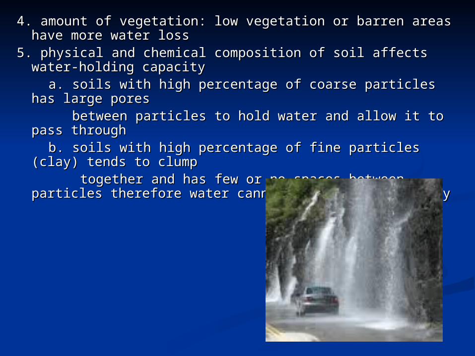
stream formsstream forms4. 4. watershedwatershed ( (drainage basin)drainage basin) = all of land area whose = all of land area whose
water drains into water drains into a stream a stream systemsystem
a. can be small or extremely large areasa. can be small or extremely large areas b. b. dividesdivides = ridges or elevated regions of high ground = ridges or elevated regions of high ground
that separate that separate watershedswatersheds c. each tributary has its own c. each tributary has its own
watershed and divides but are all watershed and divides but are all part of larger stream system part of larger stream system
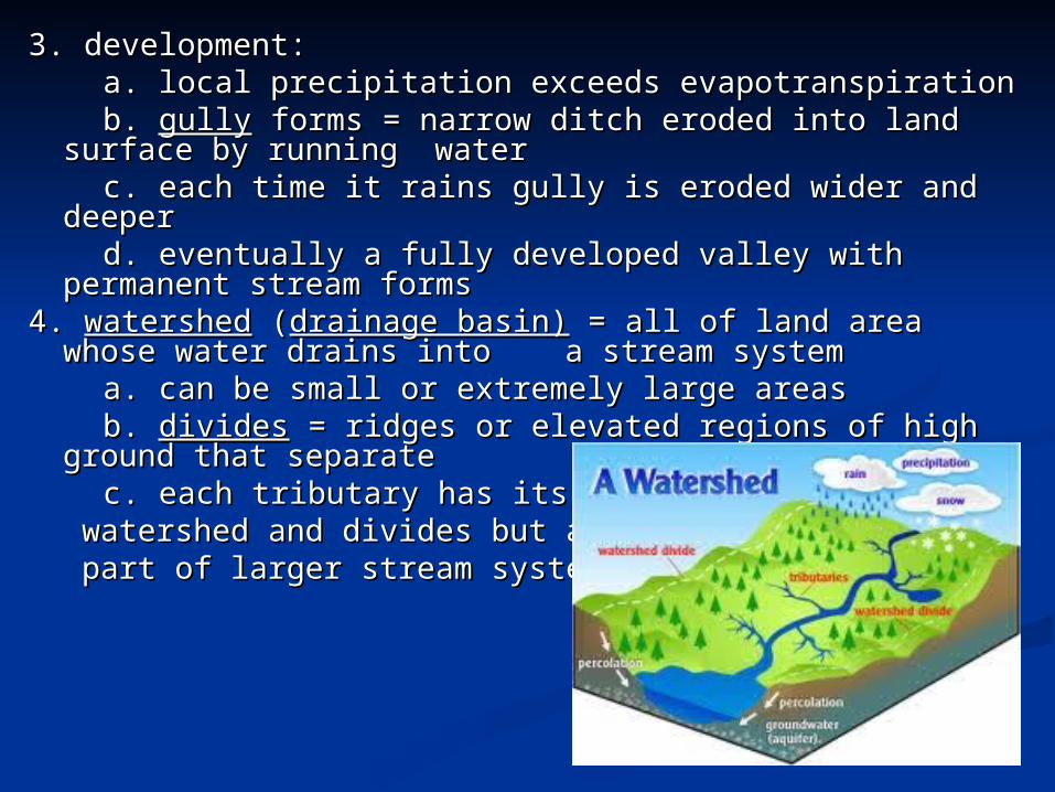
stream loadsstream loads = materials carried by a stream = materials carried by a stream1. 1. dissolved loaddissolved load = mineral matter carried in liquid solution = mineral matter carried in liquid solution a. how much is carried in solution depends on material a. how much is carried in solution depends on material
through which through which water has passedwater has passed
b. groundwater adds most of dissolved load to stream, b. groundwater adds most of dissolved load to stream, while runoff while runoff adds small amountsadds small amounts
c. expressed as parts per million (ppm) c. expressed as parts per million (ppm) 2. 2. suspended loadsuspended load = sediment carried in suspension, free = sediment carried in suspension, free
from contact from contact with stream bed with stream bed a. particles of fine sand and silta. particles of fine sand and silt b. amount of material suspended varies with volume and b. amount of material suspended varies with volume and
velocity of velocity of water water c. faster moving water can carry c. faster moving water can carry
larger particleslarger particles d. as water slows, heavier particles d. as water slows, heavier particles
will begin to settle outwill begin to settle out

3. 3. bed loadbed load = sediment transported on or immediately above = sediment transported on or immediately above stream bedstream bed
a. larger, coarser material like gravel and pebblesa. larger, coarser material like gravel and pebbles b. b. saltationsaltation = movement of material by short jumps = movement of material by short jumps c. material is also moved by sliding or rolling on stream bedc. material is also moved by sliding or rolling on stream bed d. greatest erosional effect due to abrasiond. greatest erosional effect due to abrasion e. e. potholepothole = bowl shaped cavity in bed caused by large = bowl shaped cavity in bed caused by large
rocks being rocks being scraped over one area in a whirlpool scraped over one area in a whirlpool motionmotion
STREAM CHARACTERISTICSSTREAM CHARACTERISTICS1. 1. banksbanks = edges of stream channel above water level = edges of stream channel above water level2. 2. bedbed = part of stream channel below water level = part of stream channel below water level4. 4. carrying capacitycarrying capacity = ability of stream to transport materials = ability of stream to transport materials a. depends on both velocity and amount of water movinga. depends on both velocity and amount of water moving b. channel’s slope, depth, & width all affect speed & b. channel’s slope, depth, & width all affect speed &
direction of water direction of water movementmovement
5. 5. dischargedischarge = volume of water that flows over a specific = volume of water that flows over a specific location within a given time periodlocation within a given time period
a. affected by velocity of watera. affected by velocity of water b. high velocity = high discharge = high erosionb. high velocity = high discharge = high erosion c. discharge = width X depth X velocityc. discharge = width X depth X velocity (m3/s) (m) (m) (m/s)(m3/s) (m) (m) (m/s) d. as discharge increases, carrying capacity increases, d. as discharge increases, carrying capacity increases,
erosion increaseserosion increases

6. 6. gradientgradient = change in elevation of stream over a = change in elevation of stream over a given horizontal given horizontal distance distance
a. determines velocity of streama. determines velocity of stream b. can vary along a stream channelb. can vary along a stream channel c. headwater region will have steep gradient c. headwater region will have steep gradient →→ high high
velocityvelocity7. 7. water gapwater gap = deep notch left where stream erodes = deep notch left where stream erodes
through mountain through mountain as it is upliftedas it is uplifted8. 8. wind gapwind gap = water eroded notch in mountain through = water eroded notch in mountain through
which water no which water no longer flows longer flows

floodflood = when water spills over sides of stream’s banks = when water spills over sides of stream’s banks onto adjacent onto adjacent land land
1. floodwater carries large amounts of eroded sediments1. floodwater carries large amounts of eroded sediments2. as floodwater recedes, its volume and speed decrease, 2. as floodwater recedes, its volume and speed decrease,
causing water to drop sedimentscausing water to drop sediments3. 3. flood stageflood stage = level at which a stream overflows its = level at which a stream overflows its
banks and crest of banks and crest of stream is maximum stream is maximum heightheight
4. it takes time for runoff to collect in streams, which 4. it takes time for runoff to collect in streams, which causes water to continue to rise and may reach its crest causes water to continue to rise and may reach its crest days after precipitation has stoppeddays after precipitation has stopped
5. 5. upstream floodupstream flood = flooding of a small area, cause a lot = flooding of a small area, cause a lot of damage in of damage in short period short period

6. 6. downstream floodsdownstream floods = heavy accumulations of excess = heavy accumulations of excess water from large regional drainage systems; heavy water from large regional drainage systems; heavy water volume, extensive damagewater volume, extensive damage
7. flood monitoring and warning system7. flood monitoring and warning system a. monitored by National Weather Servicea. monitored by National Weather Service b. have established b. have established gauging stationsgauging stations = provide = provide
continuous record of continuous record of water level in each streamwater level in each stream c. warning system is first step in implementing c. warning system is first step in implementing
emergency emergency management plansmanagement plans d. allows people to safely d. allows people to safely evacuate an area in advance evacuate an area in advance of the floodof the flood

Stream Development:Stream Development:1. changes in shape, width, size, and landscapes over 1. changes in shape, width, size, and landscapes over
which it flowswhich it flows2. first and most important condition is adequate 2. first and most important condition is adequate
supply of watersupply of water3. 3. headwatersheadwaters = region where water first = region where water first
accumulates to supply a accumulates to supply a stream stream a. usually high in mountainous areasa. usually high in mountainous areas b. path not well defined when first begins to flowb. path not well defined when first begins to flow

4. 4. stream channelstream channel = narrow pathway carved into sediment or = narrow pathway carved into sediment or rockrock
a. network formed by main streams and its tributariesa. network formed by main streams and its tributaries b. widens and deepens as more water accumulates and cuts b. widens and deepens as more water accumulates and cuts
into into surfacesurface5. 5. stream banksstream banks = ground bordering stream on each side which = ground bordering stream on each side which
holds holds water within area of stream water within area of stream6. 6. mouth mouth = area of stream that leads into ocean or another large = area of stream that leads into ocean or another large
body body of waterof water a. streambed’s gradient flattens out and its channel becomes a. streambed’s gradient flattens out and its channel becomes
very widevery wide
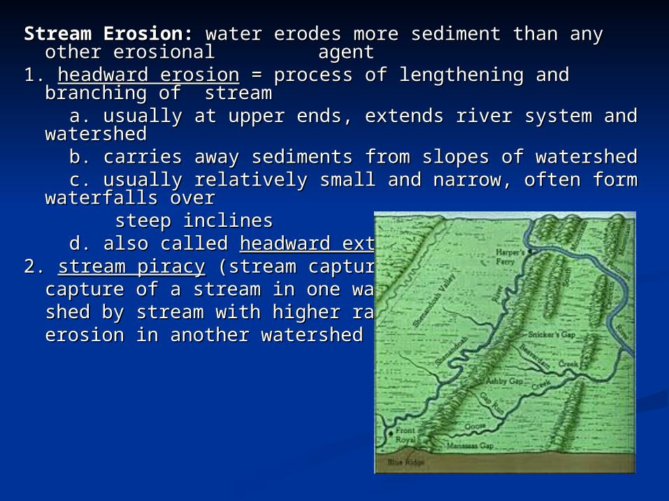
Stream Erosion: Stream Erosion: water erodes more sediment than any water erodes more sediment than any other erosional other erosional agent agent
1. 1. headward erosionheadward erosion = process of lengthening and branching = process of lengthening and branching of streamof stream
a. usually at upper ends, extends river system and a. usually at upper ends, extends river system and watershedwatershed
b. carries away sediments from slopes of watershed b. carries away sediments from slopes of watershed c. usually relatively small and narrow, often form c. usually relatively small and narrow, often form
waterfalls over waterfalls over steep inclinessteep inclines d. also called d. also called headward extensionheadward extension2. 2. stream piracystream piracy (stream capture) = (stream capture) =
capture of a stream in one water-capture of a stream in one water-shed by stream with higher rate of shed by stream with higher rate of erosion in another watershed erosion in another watershed

3. 3. rill erosionrill erosion = water swiftly running down a slope creates = water swiftly running down a slope creates small channels small channels in soilin soil
a. begins when small stream forms during heavy raina. begins when small stream forms during heavy rain b. leaves a scar on slopeb. leaves a scar on slope4. 4. gully erosiongully erosion = rill channel that becomes broader and = rill channel that becomes broader and
deeperdeeper5. 5. sheet erosionsheet erosion = water flowing over a gentle slope slowly = water flowing over a gentle slope slowly
removes removes sediment from entire land surface sediment from entire land surface6. erodes a V-shaped channel into region6. erodes a V-shaped channel into region a. continue to erode until it reaches a. continue to erode until it reaches base levelbase level = elevation = elevation
at which it at which it enters another stream or body of waterenters another stream or body of water b. lowest base level = sea levelb. lowest base level = sea level

STAGES OF A RIVER SYSTEMSTAGES OF A RIVER SYSTEM1. 1. young riversyoung rivers = produces a V-shaped valley with = produces a V-shaped valley with
steep sidessteep sides a. found in mountainous or hilly regionsa. found in mountainous or hilly regions b. may have white water rapids and waterfallsb. may have white water rapids and waterfalls c. high level of energyc. high level of energy d. erodes bed more than banksd. erodes bed more than banks e. few tributaries and usually carries a small volume e. few tributaries and usually carries a small volume
of waterof water2. 2. mature riversmature rivers = curving stream that flows down a = curving stream that flows down a
gradual slope gradual slope and erodes its sides and erodes its sides a. well established tributaries and carries more a. well established tributaries and carries more
waterwater b. gradient less steep = flows less swiftly b. gradient less steep = flows less swiftly →→ channel channel
gets widergets wider c. erodes valley walls and widens valley c. erodes valley walls and widens valley
floor gradually forming U-shaped valleyfloor gradually forming U-shaped valley

d. velocity of water in a river is fastest at the center d. velocity of water in a river is fastest at the center 1) increases on outside of river bends1) increases on outside of river bends 2) decreases on inside of curves2) decreases on inside of curvese. forms e. forms meandersmeanders = wide curves that form in streams = wide curves that form in streams 1) will continue to develop and become wider over time1) will continue to develop and become wider over time 2) after some degree of winding common for stream to 2) after some degree of winding common for stream to
cut off cut off f. f. oxbow lakeoxbow lake = water remaining in an isolated meander in = water remaining in an isolated meander in
a floodplain a floodplain 1) crescent shaped lake forms1) crescent shaped lake forms 2) ends become plugged with sediment2) ends become plugged with sediment 3) will eventually dry up3) will eventually dry upg. found at bottom of g. found at bottom of mountains and hillsmountains and hills
Oxbow lake formation

3. 3. old rivers old rivers = flows very slowly through a very broad, = flows very slowly through a very broad, flat floodplain flat floodplain that it has carvedthat it has carved
a. gradient and velocity decreasea. gradient and velocity decrease b. no longer erodes landb. no longer erodes land c. causes changes in the meandersc. causes changes in the meanders d. fewer tributariesd. fewer tributaries e. begins to deposit sediment in channel and on bankse. begins to deposit sediment in channel and on banks4. 4. rejuvenated riverrejuvenated river = gradient has been made steeper = gradient has been made steeper
by movement of by movement of earth’s crustearth’s crust a. stream will resume process of downcutting toward a. stream will resume process of downcutting toward
its base levelits base level b. cut more deeply into valley floorb. cut more deeply into valley floor c. cause increase in stream’s flow rate and channel c. cause increase in stream’s flow rate and channel
will become V-shaped againwill become V-shaped again d. if meanders are present then deep side d. if meanders are present then deep side
canyons could be formedcanyons could be formed

STREAM DEPOSITIONSTREAM DEPOSITION1. as water velocity decreases the ability to carry sediment 1. as water velocity decreases the ability to carry sediment decreasesdecreases2. 2. deltadelta = triangular shaped deposit at mouth of a stream = triangular shaped deposit at mouth of a stream a. shape and size determined by waves, tides, off-shore a. shape and size determined by waves, tides, off-shore depths, and sediment load of streamdepths, and sediment load of stream b. occurs when a stream or river slows as it empties into b. occurs when a stream or river slows as it empties into an ocean, gulf, or lakean ocean, gulf, or lake c. sediments build up & slow stream water, sometimes c. sediments build up & slow stream water, sometimes even blocking its movementeven blocking its movement d. usually made up of consist of d. usually made up of consist of
silt and claysilt and clay e. surface is relatively flate. surface is relatively flat

3. 3. alluvial fanalluvial fan = fan shaped deposit with its tip pointing = fan shaped deposit with its tip pointing upstreamupstream
a. occurs where stream descending steep slope a. occurs where stream descending steep slope reaches a flat plainreaches a flat plain
b. common in arid and semiarid regions; dry, b. common in arid and semiarid regions; dry, mountainous regionsmountainous regions
Ex: Death Valley, CAEx: Death Valley, CA c. deposited on dry groundc. deposited on dry ground d. contains coarse, angular sand and graveld. contains coarse, angular sand and gravel e. form at the base of slopese. form at the base of slopes4. 4. barbar = elongated mound of sediment in stream channel = elongated mound of sediment in stream channel

5. 5. floodplainfloodplain = broad, flat valley floor carved by a = broad, flat valley floor carved by a meandering streammeandering stream
a. often covered with water if stream floodsa. often covered with water if stream floods b. spring floods common near headwaters in areas b. spring floods common near headwaters in areas
where the winters where the winters are harshare harsh
c. ice jams increase chance of spring floodingc. ice jams increase chance of spring flooding d. human activities contribute to floodingd. human activities contribute to flooding
- removal of natural ground cover- removal of natural ground cover e. commonly swampy arease. commonly swampy areas6. 6. natural leveenatural levee = raised riverbank that results when a = raised riverbank that results when a
river deposits its river deposits its load at river’s edges load at river’s edges a. can be quite high and prominent a. can be quite high and prominent
on old channelson old channels b. usually coarser sedimentb. usually coarser sediment c. can be on both banks c. can be on both banks

LAKES & FRESHWATE R WETLANDSLAKES & FRESHWATE R WETLANDS1. 1. lake lake = depression in surface materials of landscape = depression in surface materials of landscape
that collects and that collects and holds water holds water a. gain water from streams and runoffa. gain water from streams and runoff b. get water from local precipitation, springs, and b. get water from local precipitation, springs, and
other sourcesother sources c. most have outlets from which water flows to rivers c. most have outlets from which water flows to rivers
and to oceanand to ocean d. d. reservoirsreservoirs = lakes made for primary purpose of = lakes made for primary purpose of
storing water for storing water for community’s use community’s use e. e. pondsponds = manmade lake used for watering = manmade lake used for watering
livestock, attracting livestock, attracting wildlife, natural wildlife, natural beauty, etc.beauty, etc.

2. lake formation2. lake formation a. oxbow lakes form when meanders get cut off from main a. oxbow lakes form when meanders get cut off from main
streamstream b. could also be formed when stream flow becomes blocked b. could also be formed when stream flow becomes blocked
by by sediment from landslidessediment from landslides c. could be remnants of prehistoric lakes that have receded c. could be remnants of prehistoric lakes that have receded
to lower to lower lying areaslying areas d. some are formed by glacier movement d. some are formed by glacier movement e. e. kettle lakeskettle lakes = formed when blocks of ice left by melting = formed when blocks of ice left by melting
glaciers glaciers eventually melted in depression eventually melted in depression f. can also be found in areas where f. can also be found in areas where
limestone bedrock is located limestone bedrock is located →→ water dissolves holes and water dissolves holes and forms cavernsforms caverns

3. undergo change3. undergo change a. precipitation, runoff, and underground sources a. precipitation, runoff, and underground sources
maintain a maintain a lake’s water supplylake’s water supply b. depression that receives more water than it loses b. depression that receives more water than it loses
to evaporation or to evaporation or use by humans will exist for a long period of timeuse by humans will exist for a long period of time c. considered temporary water-holding areasc. considered temporary water-holding areas d. over hundreds of thousands of years, usually fill d. over hundreds of thousands of years, usually fill
with sediment with sediment and become part of new landscapeand become part of new landscape
Volcanic lake

4. 4. eutrophicationeutrophication = process by which lakes become rich in = process by which lakes become rich in nutrients nutrients from surrounding watershed causing a from surrounding watershed causing a change in the kinds of change in the kinds of organisms in the lakeorganisms in the lake
a. animals that live in lake use water’s oxygen and add a. animals that live in lake use water’s oxygen and add waste products waste products
to waterto water b. amount of dissolved oxygen helps determine quality b. amount of dissolved oxygen helps determine quality
of water and of water and ability to support lifeability to support life
c. can be sped up with the addition of nutrients c. can be sped up with the addition of nutrients (fertilizers)(fertilizers)
d. may cause excess algae and d. may cause excess algae and excess organisms that feed excess organisms that feed on algae which may use too on algae which may use too much dissolved oxygen much dissolved oxygen
causing fish and other causing fish and other sensitive organisms to diesensitive organisms to die

5. 5. wetlandwetland = land area that is covered with water for large = land area that is covered with water for large part of yearpart of year
a. a. bogsbogs = receive water from precipitation, waterlogged = receive water from precipitation, waterlogged soil rich in soil rich in peat moss, acidic soil peat moss, acidic soil
b. b. freshwater marshesfreshwater marshes = form along mouths of streams = form along mouths of streams and in areas and in areas with extensive deltas with extensive deltas
c. c. swampsswamps = low lying areas often located near streams = low lying areas often located near streams 1) may develop from marshes1) may develop from marshes 2) prehistoric swamps formed 2) prehistoric swamps formed
coal reserves used todaycoal reserves used today

6. wetlands improve water quality6. wetlands improve water quality a. act as filtering system that traps pollutants, a. act as filtering system that traps pollutants,
sediments, & sediments, & pathogenic bacteria in water sourcespathogenic bacteria in water sources b. provide vital habitats for migratory waterbirdsb. provide vital habitats for migratory waterbirds c. provide homes for many other types of wildlifec. provide homes for many other types of wildlife7. in the past humans have filled in wetlands to create 7. in the past humans have filled in wetlands to create
more more land to build onland to build on8. preservation of these have now become a global 8. preservation of these have now become a global
concernconcern

FLOOD CONTROLFLOOD CONTROL1. flooding is natural stage of development of stream1. flooding is natural stage of development of stream a. will continue to occur as stream maturesa. will continue to occur as stream matures b. best to leave floodplains in natural state in areasb. best to leave floodplains in natural state in areas2. indirect methods: forest and soil conservation that 2. indirect methods: forest and soil conservation that
prevents excess runoff during heavy rainfallprevents excess runoff during heavy rainfall3. direct methods3. direct methods a. building of a dama. building of a dam b. building of artificial leveesb. building of artificial levees c. create c. create floodwayfloodway = permanent = permanent
overflow channeloverflow channel

PREVENTING LAND EROSION:PREVENTING LAND EROSION:1. planting vegetation1. planting vegetation2. build 2. build terracesterraces = broad, steplike cuts made = broad, steplike cuts made
into the side of into the side of a slopea slope3. put up retaining walls3. put up retaining walls
Stream retaining wall
Terraces