Supplemental Phase II Environmental Site Assessment Former ...

Supplemental Environmental Assessment (SEA) and Finding of No Significant Impact (FONSI)
SPACE BASED INFRARED SYSTEM (SBIRS)MISSION CONTROL STATION FOR
DEFENSE SUPPORT PROGRAM CONSOLIDATION
United States Air ForceHeadquarters Space and Missile Systems Center
Buckley AFB, ColoradoMarch 2001
Report Documentation Page
Report Date 00032001
Report Type N/A
Dates Covered (from... to) -
Title and Subtitle Supplemental Environmental Assessment (SEA) to the SpaceBased Infrared System (SBIRS) Mission Control Station forDefense Support Program Consolidation
Contract Number F41624-95-D-9018
Grant Number
Program Element Number
Author(s) Project Number
Task Number
Work Unit Number
Performing Organization Name(s) and Address(es) United States Air Force Headquarters Space and MissileSystems Center Buckley AFB, Colorado Los Angeles AFB, CA90245
Performing Organization Report Number
Sponsoring/Monitoring Agency Name(s) and Address(es) Space and Missile Systems Center Los Angeles Air Force Base,CA Institute for Environmental, Safety, and Occupational HealthRisk Analysis (IERA) Brooks AFB, Texas
Sponsor/Monitor’s Acronym(s)
Sponsor/Monitor’s Report Number(s)
Distribution/Availability Statement Approved for public release, distribution unlimited
Supplementary Notes The original document contains color images.
Abstract
Subject Terms
Report Classification unclassified
Classification of this page unclassified
Classification of Abstract unclassified
Limitation of Abstract UU
Number of Pages 132


Supplemental Environmental Assessment (SEA)to the
Space Based Infrared Systems (SBIRS)Mission Control Station for
Defense Support Program Consolidation
2nd Space Warning SquadronBuckley Air Force Base, Colorado
Prepared for
Acquisition Civil Engineer DivisionEnvironmental Management Branch
Space and Missile Systems CenterLos Angeles Air Force Base, California
and
Institute for Environment, Safety, andOccupational Health Risk Analysis (IERA)
Brooks Air Force Base, Texas
March 2001
Contract F41624-95-D-9018, Order 0062
Printed on 30 Percent Recycled Paper

Supplemental Environmental AssessmentCover Sheet SBIRS MCS for Defense Support Program Consolidation at Buckley AFB, CO
S-1 March 2001
COVER SHEET
SUPPLEMENTAL ENVIRONMENTAL ASSESSMENT (SEA) TOTHE
SPACE BASED INFRARED SYSTEMS (SBIRS)MISSION CONTROL STATION FOR DEFENSE SUPPORT
PROGRAM CONSOLIDATIONBUCKLEY AIR FORCE BASE, COLORADO
• Responsible Agency: United States Air Force (USAF), Space and MissileSystems Center (SMC), Los Angeles Air Force Base (AFB), California.
• Proposed Action: Accomplish the construction, installation, and operation oftwo SBIRS radio frequency (RF) antennas at the Mission Control Station (MCS)site at Buckley AFB, Colorado.
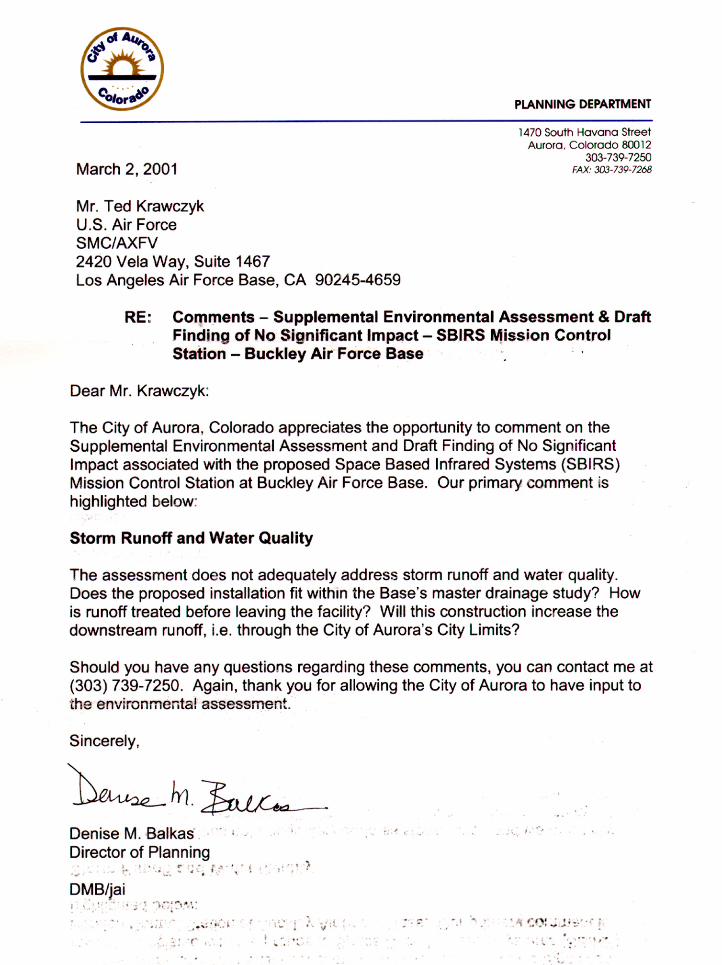
• Written comments and inquiries regarding this document should be directed to:Mr. Ted Krawczyk, U.S. Air Force, SMC/AXFV, 2420 Vela Way, Suite 1467,Los Angeles AFB, El Segundo, CA, 90245-4659 prior to 5:00 P.M. MST onFebruary 24, 2001.
• Report Designation: Supplemental Environmental Assessment (EA).
• Abstract: The purpose of the Proposed Action is to accomplish the constructionand operation of two 10-meter diameter SBIRS RF antennas to support the SMCmission at Buckley AFB, Colorado. These antennas would be part of the SBIRSMCS facility located on the western portion of Buckley AFB. The antennaswould be operated by existing SBIRS personnel; no additional manpower wouldbe required. Additionally, three smaller antennas may be erected near this samelocation as part of the continuing SBIRS mission to provide global coverage. TheProposed Action is supplemental to the SBIRS MCS EA which already describes theSBIRS MCS (USAF SMC, 1996). This supplemental EA evaluates the ProposedActions and the No Action Alternative. Under the No Action Alternative, theSBIRS mission would be seriously degraded. The SBIRS antennas would not beinstalled and the 2 SWS would continue to rely on the Defense Support Program(DSP) antenna system. The DSP antennas are over 25-years old, beyond their lifeexpectancy, and will not work with the new SBIRS geostationary earth orbit(GEO) satellites. The SBIRS GEO satellites use state-of-the-art, highly flexible,tasking infrared sensor technology to detect and track shorter-range missiles withgreater accuracy, and are partially incompatible with the DSP antennas.Resources considered in the impact analysis were: air quality, biologicalresources, non-ionizing RF energy, and utilities. No significant impacts wouldresult from the Proposed Action or the No Action Alternative.

Supplemental Environmental AssessmentCover Sheet SBIRS MCS for Defense Support Program Consolidation at Buckley AFB, CO
S-2 March 2001
THIS PAGE INTENTIONALLY LEFT BLANK
Supplemental Environmental AssessmentTable of Contents SBIRS MCS for Defense Support Program Consolidation at Buckley AFB, CO
i March 2001
TABLE OF CONTENTS
LIST OF FIGURES ........................................................................................................IIILIST OF TABLES..........................................................................................................IIIACRONYMS AND ABBREVIATIONS....................................................................... IVSECTION 1 PURPOSE OF AND NEED FOR PROPOSED ACTION ................. 1-1
1.1 Background ............................................................................................... 1-11.2 Purpose of and Need for the Proposed Action .......................................... 1-21.3 Proposed action ......................................................................................... 1-31.4 Location of the Proposed Action............................................................... 1-31.5 Scope of the Environmental Review......................................................... 1-4
1.5.1 Identification of Biophysical ResourcesApplicable to the Supplemental EA................................................... 1-8
1.5.2 Statement of the Baseline Condition and Analysis Period .............. 1-121.5.3 Environmental Justice...................................................................... 1-121.5.4 Other Actions Considered for Cumulative Impact Purposes ........... 1-12
1.6 Introduction to the Organization of the Document ................................. 1-13SECTION 2 DESCRIPTION OF THE PROPOSED ACTION
AND ALTERNATIVES ........................................................................ 2-12.1 History of the Formulation of Alternatives ............................................... 2-12.2 Alternatives Eliminated from Further Consideration................................ 2-12.3 Detailed Description of the Proposed Action............................................ 2-2
2.3.1 Proposed Action................................................................................. 2-22.3.2 Antenna Construction ........................................................................ 2-22.3.3 Antenna Operation ............................................................................. 2-9
2.4 Description of the No Action Alternative ............................................... 2-102.5 Other Actions Announced for Buckley AFB .......................................... 2-102.6 Comparison of Environmental Effects of All Alternatives..................... 2-112.7 Identification of the Preferred Alternative .............................................. 2-112.8 Mitigation Measures................................................................................ 2-11
SECTION 3 AFFECTED ENVIRONMENT ............................................................ 3-13.1 Air Quality................................................................................................. 3-1
3.1.1 Air Pollutants and Regulations .......................................................... 3-13.1.2 Meteorology ....................................................................................... 3-43.1.3 Regional Air Quality.......................................................................... 3-43.1.4 Baseline Air Emissions ...................................................................... 3-6
3.2 Biological Resources................................................................................. 3-73.2.1 Vegetation and Wildlife ..................................................................... 3-83.2.2 Threatened, Endangered and Special Concern Species ..................... 3-93.2.3 Sensitive Habitat .............................................................................. 3-12

Supplemental Environmental AssessmentTable of Contents SBIRS MCS for Defense Support Program Consolidation at Buckley AFB, CO
ii March 2001
TABLE OF CONTENTS(...continued)
3.3 Non-ionizing Energy ............................................................................... 3-123.3.1 Health and Safety ............................................................................. 3-123.3.2 Airspace ........................................................................................... 3-13
3.4 Utilities.................................................................................................... 3-143.4.1 Electricity ......................................................................................... 3-143.4.2 Natural Gas ...................................................................................... 3-14
SECTION 4 ENVIRONMENTAL CONSEQUENCES........................................... 4-14.1 Air Quality................................................................................................. 4-1
4.1.1 Proposed Action................................................................................. 4-14.1.2 No Action Alternative........................................................................ 4-44.1.3 Mitigative Measures........................................................................... 4-44.1.4 Cumulative Impacts ........................................................................... 4-4
4.2 Biological Resources................................................................................. 4-54.2.1 Proposed Action................................................................................. 4-54.2.2 No Action Alternative........................................................................ 4-64.2.3 Mitigative Measures........................................................................... 4-64.2.4 Cumulative Impacts ........................................................................... 4-7
4.3 Non-ionizing Energy ................................................................................. 4-74.3.1 Proposed Action................................................................................. 4-84.3.2 No Action Alternative...................................................................... 4-114.3.3 Mitigative Measures......................................................................... 4-114.3.4 Cumulative Impacts ......................................................................... 4-12
4.4 Utilities.................................................................................................... 4-174.4.1 Electricity ......................................................................................... 4-174.4.2 Natural Gas ...................................................................................... 4-18
4.5 Unavoidable Adverse Environmental Impacts........................................ 4-194.6 Irreversible and Irretrievable Commitment of Resources ....................... 4-204.7 Relationship Between Short-Term Uses of the
Environment and Long-Term Productivity ............................................. 4-20SECTION 5 REGULATORY REVIEW AND
PERMIT REQUIREMENTS................................................................ 5-15.1 Air Quality................................................................................................. 5-15.2 Threatened, Endangered, and Sensitive Species ....................................... 5-25.3 Non-ionizing Energy ................................................................................. 5-2
SECTION 6 LIST OF PREPARERS......................................................................... 6-1SECTION 7 LIST OF PERSONS AND AGENCIES CONSULTED..................... 7-1
7.1 Federal Agencies ....................................................................................... 7-17.2 State Agencies ........................................................................................... 7-17.3 Others ........................................................................................................ 7-1

Supplemental Environmental AssessmentTable of Contents SBIRS MCS for Defense Support Program Consolidation at Buckley AFB, CO
iii March 2001
TABLE OF CONTENTS(...continued)
SECTION 8 SUPPLEMENTAL ENVIRONMENTALASSESSMENT MAILING LIST ......................................................... 8-1
8.1 Federal Agencies ....................................................................................... 8-18.2 Local Agencies.......................................................................................... 8-18.3 State Agencies ........................................................................................... 8-1
SECTION 9 REFERENCES....................................................................................... 9-1
APPENDICES
Appendix A AF Forms 813, Environmental Impact AnalysisAppendix B SBIRS Antenna Study Results by The Aerospace CorporationAppendix C DoD Joint Spectrum Energy Hazard AssessmentAppendix D Draft EA Comment Letters
LIST OF FIGURES
Figure 1-1 Location of Buckley AFB............................................................................. 1-5Figure 2-1 Site Location for Antennas SB1 and SB2 .................................................... 2-3Figure 2-2 Site Layout for Antennas SB1 and SB2 ....................................................... 2-5Figure 2-3 SBIRS SB1 and SB2 Antenna Disk and Radome ........................................ 2-7Figure 4-1 Antenna Siting of SB1, SB2, and Three Future LEO Antennas................. 4-13Figure 4-2 Location of SBIRS, LEO, and DSP Antennas............................................ 4-15
LIST OF TABLES
Table 2.1 Summary of Environmental Impacts....................................................... 2-11Table 2.2 Summary of Best Management Practices................................................ 2-13Table 3.1-1 National and State Ambient Air Quality Standards* ................................ 3-3Table 3.1-2 State of Colorado Ambient Air Quality Standards
for Sulfur Dioxide (SO2) ........................................................................... 3-4Table 3.1-3 Emissions Inventory for the Buckley AFB................................................ 3-7Table 3.2-1 Sensitive Species Occurring or
Potentially Occurring on Buckley AFB..................................................... 3-9Table 4.1-1 Proposed Construction Emissions Within AQCR 36 ............................... 4-2Table 4.1-2 Proposed Operational Emission Within AQCR 36................................... 4-4Table 4.1-3 Proposed Cumulative Emission Within AQCR 36................................... 4-5Table 4.3-1 SBIRS Antenna Operational Parameters................................................... 4-9Table 4.3-2 Maximum Power Density Levels for SBIRS and DSP Antennas ........... 4-10Table 5.1 Regulations and Permits Associated with Air Quality.............................. 5-1Table 5.2 Regulations and Permits Associated with
Threatened, Endangered, and Sensitive Species ....................................... 5-2
Acronyms Supplemental Environmental Assessmentand Abbreviations SBIRS MCS for Defense Support Program Consolidation at Buckley AFB, CO
iv March 2001
THIS PAGE INTENTIONALLY LEFT BLANK

Acronyms Supplemental Environmental Assessmentand Abbreviations SBIRS MCS for Defense Support Program Consolidation at Buckley AFB, CO
v March 2001
ACRONYMS AND ABBREVIATIONS
°F Degrees Fahrenheit2 SWS 2nd Space Warning Squadron
AFB Air Force BaseAFI Air Force Instruction
ANG Air National GuardANGB Air National Guard BaseAPEN Air Pollution Emission NoticeAQCR Air quality control regionBMPs Best management practices
Btu British thermal unitBX Base Exchange
CAA Clean Air ActCDOW Colorado Division of WildlifeCDPHE Colorado Department of Public Health and the Environment
CE Civil EngineeringCEQ Council on Environmental QualityCFR Code of Federal RegulationsCO Carbon monoxideCY Calendar yeardB Decibel
DoD Department of DefenseDSP Defense Support Program
EA Environmental assessmentEIAP Environmental impact analysis process
EIS Environmental impact statementEO Executive Order
FONSI Finding of No Significant ImpactFY Fiscal year
GEO Geostationary earth orbitGHz GigaHertzHEO Highly Elliptical OrbitsHM Hazardous materialsHQ HeadquartersHW Hazardous wasteIRP Installation restoration programJSC Joint Spectrum CenterkHz KiloHertz
kVA Kilovolt ampereskW Kilowatt
kWCm2 Kilowatts per square centimeterLBP Lead-based paintLEO Low Earth Orbit
MBtu Million British thermal units

Acronyms Supplemental Environmental Assessmentand Abbreviations SBIRS MCS for Defense Support Program Consolidation at Buckley AFB, CO
vi March 2001
ACRONYMS AND ABBREVIATIONS(...continued)
MCS Mission Control StationNAAQS National ambient air quality standards
NEPA National Environmental Policy ActNO2 Nitrogen dioxideNOx Nitrogen oxides
NRHP National Register of Historic PlacesNWI National Wetlands Inventory
O3 OzonePCB Polychlorinated biphenylPEL Permissible exposure levels
PM10 Diameter less than or equal to 10 micrometersRAQC Regional Air Quality Council
RF Radio frequencySB1 SBIRS Antenna No. 1SB2 SBIRS Antenna No. 2
SBIRS Space Based Infrared SystemsSHPO State Historic Preservation Officer
SIP State implementation planSMC Space and Missile Systems CenterSO2 Sulfur dioxideSOx Sulfur oxidesTSP Total suspended particulates
USAF United States Air ForceUSC United States Code
USEPA United States Environmental Protection AgencyUSFWS United States Fish and Wildlife Service
VOC Volatile organic compoundward Subcolony of a larger prairie dog colony
Purpose of and Need Supplemental Environmental Assessmentfor the Proposed Action SBIRS MCS for Defense Support Program Consolidation at Buckley AFB, CO
1-1 March 2001
SECTION 1PURPOSE OF AND NEED FOR
PROPOSED ACTION
This chapter includes a discussion on the background of the SBIRS High Program, astatement of the purpose and need for the Proposed Action, a statement of the ProposedAction, location of the Proposed Action, summary of the scope of the environmentalreview, and an overview of the organization of this supplemental EA.
1.1 BACKGROUND
The SBIRS High Program is a “system of systems” approach that will integrate spaceassets in multiple orbit configurations with a consolidated ground segment to providemore effective integration of data and better information to the warfighter. The SBIRSarchitecture will consist of four satellites located in Geostationary Earth Orbit (GEO), twosatellites orbiting in Highly Elliptical Orbits (HEO), and a constellation of greater than 20satellites in Low Earth Orbit (LEO) to provide global coverage in support of the SBIRSmissions. The SBIRS missions include enemy missile warning, missile defense, technicalintelligence, and battlespace characterization (LAAFB, 2001).
The SBIRS High Program is a follow-on program to the Defense Support Program(DSP) which has been in use since the 1970s. The DSP is an early warning systemoperated by the Air Force Space Command (AFSPC) and developed by the Air ForceSpace and Missile Systems Center (SMC). DSP provides 24-hour, worldwidesurveillance for missile warning and nuclear burst detection and serves as the spacesegment of the U.S. Integrated Tactical Warning and Attack Assessment System.Although the DSP has proven to be a very capable system, it was not designed to meet theevolving theater and ballistic missile threats of the 2000s. The SBIRS High Program willprovide the enhanced capabilities necessary to combat emerging threats and in turn meetU.S. infrared space surveillance needs through the next several decades (LAAFB, 2001).The legacy DSP ground stations, distributed worldwide, will be consolidated into SBIRSMission Control Station (MCS) peace time facility. The MCS will use the three existingDSP antennas since the first phase of MCS operations will use only DSP satellite data.Once the newer SBIRS radio frequency (RF) antennas become operational and equipmentin the DSP facility phases out, the existing DSP antennas will be phased out also (Miller,2001).
The SBIRS High Program will provide an enhanced follow-on capability to thecurrent DSP system using state-of-the-art, highly flexible, tasking infrared sensor
Purpose of and Need Supplemental Environmental Assessmentfor the Proposed Action SBIRS MCS for Defense Support Program Consolidation at Buckley AFB, CO
1-2 March 2001
technology to combat emerging threats. This technology will allow SBIRS to detect andtrack shorter-range missiles with greater accuracy. The benefit to the warfighter will beimproved missile launch point and impact point predictions in support of offensive anddefensive operations, and reduced impact and disruption to the fighting readiness ofdeployed forces (LAAFB, 2001).
1.2 PURPOSE OF AND NEED FOR THE PROPOSED ACTION
For over 50 years, ballistic missiles have been a threat to the United States and itsmilitary operations. During the Cold War, the strategic balance between Soviet and U.S.forces held this threat in check through the ability of each side to destroy the other afteran initial attack. Since the 1991 Gulf War, there was a proliferation of ballistic missilecapabilities throughout the world. Currently, over 20 countries now have ballisticmissiles of theater (intermediate) range. These missiles can carry and deploy nuclear,chemical, and/or biological weapons. Furthermore, an estimated 24 countries have, or arecapable of developing, these weapons of mass destruction. The U.S. Governmentconsiders the proliferation of ballistic missiles in combination with development ofweapons of mass destruction a great danger to both national and global security.
In keeping with the objectives of AFSPC, the SMC SBIRS Directorate proposes toerect two RF antennas (SB1 and SB2) as part of the SBIRS High GeosynchronousSatellite Program and three RF antennas as part of the SBIRS LEO Satellite Program.These antennas are needed to support the existing SBIRS MCS facility located on thewestern side of Buckley AFB, Colorado. The two GEO antennas, SB1 and SB2, wouldbe enclosed in radomes to protect them from the environment. Upon completion of theerection of SB1 and SB2, they would be capable of transmitting and receiving data fromGEO satellites. The antennas would be constructed on concrete foundations, withgrounding and signal duct banks interfaced with the cable duct bank attached to theexisting MCS facility. If future operating parameters for the SBIRS MCS antennas arechanged from the ones described in this supplemental EA, additional radiation hazardmitigation must be considered.
The purpose of antennas SB1 and SB2 would be to receive data for use by theGround Terminal Element Segment part of the MCS to accomplish four SBIRSmissions. These missions are vital to the early warning capability for the U.S.national defense system of the future. As stated above, all RF antennas are anintegral part of the MCS, which would be utilized by existing SBIRS personnel. TheMCS facility and its associated antennas would be used by the SBIRS GEO GroundSegment team with unique assets to provide a highly capable, cost-effective, low-riskfulfillment of the SBIRS missions. SB1 and SB2 would be capable of bothtransmitting and receiving data from the future SBIRS GEO satellites as well as the

Purpose of and Need Supplemental Environmental Assessmentfor the Proposed Action SBIRS MCS for Defense Support Program Consolidation at Buckley AFB, CO
1-3 March 2001
DSP fly-out satellites. The MCS and associated antennas would allow consolidationof three DSP operational sites and associated communication networks into a fullyintegrated ground segment that fuses all infrared energy data collected from spacewith other data to optimize performance for all SBIRS missions. The existing DSPantennas would be used for communication until fiscal year (FY) 2004 when some of theequipment inside the DSP operations facility (Building B-430) will be retired. TheMCS operations facility is located in Building B-422.
The SBIRS High Program RF antennas are the first phase of the consolidated, cost-effective, and flexible early warning system that requires specific EIAP documentationand action. A decision regarding construction and operation of the antennas at BuckleyAir Force Base (AFB) would be supported by appropriate NEPA analysis. Thissupplemental EA provides that NEPA documentation.
1.3 PROPOSED ACTION
The USAF proposes to construct and operate two 10-meter diameter SBIRS RFantennas to support the mission at Buckley AFB, Colorado. These antennas would bepart of the SBIRS MCS facility located on the western portion of Buckley AFB. Theantennas would be operated by existing SBIRS personnel; no additional manpower wouldbe required. This Proposed Action is supplemental to the SBIRS MCS EA which already
describes the SBIRS MCS (USAF SMC, 1996). Additionally, three smaller LEO antennasare planned to be erected near the proposed SBIRS antennas site in the future.Information on the LEO antennas is included in Appendix B of this supplemental EA.The information includes the LEO planned antenna locations in relation to the existingDSP and SBIRS antennas, their transmitting frequencies, transmitting power, minimumoperational elevation angles, and maximum operational times.
1.4 LOCATION OF THE PROPOSED ACTION
Buckley AFB, previously Buckley Air National Guard Base (ANGB), is locatedapproximately 4.5 miles east of Denver, Colorado on the eastern edge of the City ofAurora, in Arapahoe County. Buckley AFB occupies 3,250 acres and has been in usesince 1938. The base was realigned as an Air Force base in October 2000 (USAF, 2000).The 2nd Space Warning Squadron (2 SWS), owner and operator of the SBIRS mission, isa resident tenant at Buckley AFB. The SBIRS antennas would be located within thesecured 2 SWS complex just west of the MCS building. Additionally, in the future threesmaller LEO antennas are planned to be erected at a location near the SBIRS site. Thelocation of Buckley AFB is shown in Figure 1-1.

Purpose of and Need Supplemental Environmental Assessmentfor the Proposed Action SBIRS MCS for Defense Support Program Consolidation at Buckley AFB, CO
1-4 March 2001
THIS PAGE INTENTIONALLY LEFT BLANK

Buckley AFB
Buckley AFB, Colorado
Location of
Figure 1-1

Purpose of and Need Supplemental Environmental Assessmentfor the Proposed Action SBIRS MCS for Defense Support Program Consolidation at Buckley AFB, CO
1-6 March 2001
THIS PAGE INTENTIONALLY LEFT BLANK

Purpose of and Need Supplemental Environmental Assessmentfor the Proposed Action SBIRS MCS for Defense Support Program Consolidation at Buckley AFB, CO
1-7 March 2001
Land use surrounding Buckley AFB is changing from open, undeveloped prairie toresidential and light industrial as the City of Aurora continues to grow. On the north sideof the base is a golf course and environmental park. To the southwest, the land use isresidential with some light industrial. There are three square miles of open space parkknown as “Former Plains Conservation Center” along the southernmost border of thebase (Air National Guard (ANG), 1996).
1.5 SCOPE OF THE ENVIRONMENTAL REVIEW
Under the National Environmental Policy Act (NEPA) of 1969, Title 42, UnitedStates Code (USC), Section 4321, et seq. (42 USC 4321 et seq.), federal agencies arerequired to systematically assess the environmental consequences of Proposed Actionsduring the decision-making process. The intent of NEPA is to protect, restore, or enhancethe environment through well-informed federal decisions. The Council on EnvironmentalQuality (CEQ) was established under NEPA to implement and oversee federal policy inthis process. The CEQ issued regulations implementing the process (40 Code of FederalRegulations [CFR] 1500-1508). The CEQ regulations require that an EA:
• Briefly provide evidence and analysis to determine whether the Proposed Actionmight have significant effects that would require preparation of an environmentalimpact statement (EIS). If the analysis determines that the environmental effectswill not be significant, a Finding of No Significant Impact (FONSI) will beprepared.
• Facilitate preparation of an EIS, when required.
This supplemental EA provides the basis for determining the degree ofenvironmental impacts of the Proposed and Alternative Actions. This supplemental EAis part of the EIAP for the Proposed project as set forth in Air Force Instruction 32-7061,The Environmental Impact Analysis Process, January 24, 1995 as promulgated in 32CFR 989, effective July 15, 1999, which implements NEPA, CEQ regulations,Department of Defense (DoD) Instruction 4715.9, Environmental Planning and Analysis,May 3, 1996, and Air Force Policy Directive 32-70, Environmental Quality, July 20,1994.
This supplemental EA identifies, describes, and evaluates the potentialenvironmental impacts that may result from the implementation of the Proposed Actionor No Action Alternative, and includes possible cumulative impacts from all reasonablyforeseeable activities at the base. It also identifies required environmental permitsrelevant to the Proposed Action. As appropriate, the affected environment andenvironmental consequences of the Proposed Action or No Action Alternative may bedescribed in terms of site-specific descriptions or regional overview. Finally, this
Purpose of and Need Supplemental Environmental Assessmentfor the Proposed Action SBIRS MCS for Defense Support Program Consolidation at Buckley AFB, CO
1-8 March 2001
supplemental EA identifies measures to prevent or minimize adverse environmentalimpacts.
The SBIRS MCS site was previously analyzed in an EA with a FONSI completed bythe Environmental Protection Committee at Buckley ANGB on 12 April 1996 (USAFSMC, 1996). The SBIRS MCS EA assessed the environmental impacts associated withconstructing and operating the new MCS facility to consolidate DSP operations. TheSBIRS antennas in this supplemental EA were previously not analyzed in the SBIRSMCS EA. The MCS continues to use the existing DSP antennas at 2 SWS to carry out itsmission, and now requires use of state-of-the-art, highly flexible, and enhancedequipment for communicating with existing and future early warning satellite systems.This supplemental EA will incorporate pertinent information from the previous SBIRSMCS EA, as appropriate, and supplement it with the analysis for construction andoperation of the two SBIRS RF antennas.
1.5.1 Identification of Biophysical Resources Applicable to the Supplemental EA
All Proposed Action activities would occur within developed, secured areas withhighly modified and disturbed landscape at Buckley AFB.
The biophysical resources which could be impacted and which are thereby analyzedin this supplemental EA include: air quality, biological resources, non-ionizing RFenergy, and utilities (electric and natural gas). The following biophysical resources arenot included for detailed analysis because they were either previously included in theSBIRS MCS EA, other relevant EAs, or were not applicable.
Cultural Resources
There are currently no structures at Buckley AFB listed in the National Register ofHistoric Places (NRHP). The historical building survey recorded 59 World War II-erastructures on the base, and a review of the study documentation by the State HistoricPreservation Officer (SHPO) determined that none of the buildings or sites were eligiblefor the NRHP. Cultural resources inventory for Buckley AFB lists 39 archaeological sitesand 25 isolated finds. These include 32 sites with prehistoric components, three siteswith prehistoric and historic components, and four historic properties. All archaeologicalsites, as well as isolated finds, were judged to be ineligible for nomination to the NRHP,and no further work was recommended at any of these locations. Additionally, a letterfrom the SHPO stated that results of their research indicated no known cultural resourceswithin the SBIRS MCS site (USAF SMC, 1996). Therefore, no archaeological orhistorical resources are addressed further in this supplemental EA.

Purpose of and Need Supplemental Environmental Assessmentfor the Proposed Action SBIRS MCS for Defense Support Program Consolidation at Buckley AFB, CO
1-9 March 2001
Geological Resources
Geological resources were previously analyzed in the SBIRS MCS EA. Impacts togeology and soils were found to be minimal. Construction activity would occur within anarea in which the soils and topography have been previously disturbed and modified bybuilding construction. The two SBIRS antennas would be located just west of the MCSfacility in an area that has also been previously disturbed. Therefore, no adverse effectsto geological resources are anticipated and are not addressed further in this supplementalEA.
Hazardous Waste and Hazardous Materials Management
Hazardous waste (HW) and hazardous materials (HM) management was previouslyanalyzed in the SBIRS MCS EA. The Proposed Action would generate negligibleamounts of HW and HM usage during construction of the antennas. These wastes wouldbe handled according to the base Hazardous Waste Management Plan and ColoradoHazardous Waste Management Regulations. Therefore, no adverse effects from HW orHM management are anticipated and are not addressed further in this supplemental EA.
Installation Restoration Program (IRP)
The Proposed Action would not involve disturbances at any IRP sites. Therefore, noadverse effects to the IRP are anticipated and are not addressed further in thissupplemental EA.
Lead-based Paint (LBP)
The Proposed Action would not include the use of LBP during construction oroperation of the antennas or appurtenant structures, nor would it involve buildings usedfor lodging or housing. Therefore, no adverse effects from LBP are anticipated and arenot addressed further in this supplemental EA.
Pesticides
The Proposed Action would not include the use of pesticides during construction oroperation of the antennas or appurtenant structures. Therefore, no adverse effects fromthe storage, handling, or use of pesticides are anticipated and are not addressed further inthis supplemental EA.

Purpose of and Need Supplemental Environmental Assessmentfor the Proposed Action SBIRS MCS for Defense Support Program Consolidation at Buckley AFB, CO
1-10 March 2001
Polychlorinated Biphenyls (PCBs)
The Proposed Action would not include the use of equipment or transformerscontaining PCBs. Therefore, no adverse effects from PCBs are anticipated and are notaddressed further in this supplemental EA.
Radon
The Proposed Action would not include the use of structures which would beoccupied on a full-time basis. Therefore, screening of SBIRS personnel for radonexposure is not necessary and is not addressed further in this supplemental EA.
Noise
The Proposed Action would not alter current flying mission operations. The primarysource of noise resulting from the Proposed Action would be generated by constructionequipment and vehicles during site preparation and foundation construction.Construction noise would be intermittent, limited to normal daytime hours, and short-term in duration. Typical noise levels generated by these activities range from 75 to 89decibels at 50 feet from the source. Additionally, noise resulting from constructionactivity was previously analyzed in the SBIRS MCS EA. Construction activity for theProposed Action would be less than what occurred during the construction of the MCSfacility. Therefore, no adverse effects from noise are anticipated and are not addressedfurther in this supplemental EA.
Socioeconomics
Military personnel authorizations would remain unchanged from that of the currentmission requirements (i.e., baseline for this supplemental EA). For this reason, thecommunity setting, which is influenced by personnel factors and considers items such ashousing, population demographics, economy, and employment, would not be affected bythe Proposed Action. Therefore, socioeconomics (community setting) are not assessed inthis supplemental EA. The current overall level of Buckley AFB staffing was assessed inan EA entitled Buckley Air National Guard Base Realignment, Buckley Air NationalGuard Base, Colorado, September 2000 (USAF, 2000). Therefore, no adverse effects tosocioeconomics are anticipated and are not addressed further in this supplemental EA.
Transportation
The effects of vehicle transportation on base during peak travel times and duringconstruction of the MCS facility were previously analyzed in the Buckley ANGBRealignment EA and the SBIRS MCS EA, respectively (USAF, 2000; USAF SMC,1996). The base realignment EA assessed impacts of increasing base traffic by 90

Purpose of and Need Supplemental Environmental Assessmentfor the Proposed Action SBIRS MCS for Defense Support Program Consolidation at Buckley AFB, CO
1-11 March 2001
government vehicles and 380 personal vehicles on the main base roads. The EAconcluded there would not be a significant impact on average daily traffic on base.Additionally, during construction activities for the Proposed Action, heavy constructionequipment such as bulldozers, dump trucks, and other earth-moving equipment will beparked in designated areas and should not present any interference to base operations.The proposed site is located in an area not heavily traversed by vehicles or pedestrians.Access to and from the area by construction equipment and vehicles will be from the westgate on Devil’s Thumb Avenue, which traditionally has less traffic than the north andsouth gates. Therefore, no adverse effects from transportation are anticipated and are notaddressed further in this supplemental EA.
Utilities
Utilities such as water supply and wastewater treatment were previously analyzed inthe SBIRS MCS EA and Buckley ANGB Realignment EA. The base receives its watersupply from the City of Aurora and has no water usage restrictions from the city. Thebase has a wastewater permit co-issued by the City of Aurora and the Metro WastewaterRegional District. The Metro Wastewater Regional treatment plant has enough capacityto meet the population estimates through 2010 (USAF, 2000). The Proposed Actionwould not include any new facilities requiring the use of water or generating wastewater.Electrical power and natural gas are the only utilities that will be used at the site.Therefore, no adverse effects to water and wastewater utilities are anticipated and are notaddressed further in this supplemental EA.
Water Resources
All Proposed Action activities at Buckley AFB would occur in developed,maintained areas with highly modified and disturbed landscape. There would be nodisturbance of vegetation outside developed areas of the base. The two SBIRS antennaswould be located in the secure area of the base near the MCS building. The only portionof the 100-year floodplain that impinges on the base is along East Toll Gate Creek locatedalong the southwestern, undeveloped portion of the base. According to the BuckleyANGB Realignment EA (USAF, 2000), the USFWS National Wetlands Inventory mapsidentified six potential wetland areas on base. These areas have not been inventoried ordelineated to confirm the location and extent of jurisdictional wetlands on base. The sitefor the Proposed Action is predominantly bare earth, with less than 5 percent vegetativecover, and the surrounding area is either paved or has a gravel surface. The project site isnot within any of the six potential wetland areas. Therefore, no adverse effects to waterresources are anticipated and are not addressed further in this supplemental EA.
Purpose of and Need Supplemental Environmental Assessmentfor the Proposed Action SBIRS MCS for Defense Support Program Consolidation at Buckley AFB, CO
1-12 March 2001
1.5.2 Statement of the Baseline Condition and Analysis Period
Calendar year (CY) 2000 activities will be used to establish baseline conditions.However, if CY00 data are not available, the most recent information available will beused.
As discussed in Paragraph 2.1 of Section 2 of this supplemental EA, the USAF’sbase facilities planning process is dynamic. When a development plan forimplementation in a specific year is approved, the plan is subject to fluctuations andrevisions in subsequent years. The plan is modified based on possible changes of missionrequirements (e.g., new projects may be added, others may be deleted, and the sequencefor other projects may be revised as needs change from year to year). Therefore, the plananalyzed in this supplemental EA is the current best estimate to meet projectedrequirements and is subject to change from year to year. It is a reasonable plan and servesas a reasonable basis to environmentally assess facilities requirements of the base.
1.5.3 Environmental Justice
Executive Order (EO) 12898, Federal Actions to Address Environmental Justice inMinority Populations and Low-Income Populations, encourages federal facilities toachieve “environmental justice” by identifying and addressing, as appropriate, anydisproportionately high and adverse human health or environmental effects of itsprograms, policies, and activities on minority and low-income populations.Accompanying EO 12898 was a Presidential transmittal memorandum which referencedexisting federal statutes and regulations to be used in conjunction with EO 12898. One ofthe items in this memorandum was the use of the policies and procedures of NEPA,specifically that, “Each federal agency shall analyze the environmental effects, includinghuman health, economic, and social effects, of federal actions, including effects onminority communities and low-income communities, when such analysis is required bythe NEPA 42 United States Code (USC) Section 4321, et. seq.” Based on analysisconducted for this supplemental EA, it was determined that activities associated with theProposed Action and No Action Alternative would not have adverse effects onpopulations for the following resources: air quality, non-ionizing energy, biologicalresources, and utilities. Additionally, it was determined in the Buckley ANGBRealignment EA that there would not be an overall disproportionately adverseenvironmental or human health effect on the minority population. Therefore, nodisproportionately high or adverse impacts on minority and low-income populations areexpected to occur.
1.5.4 Other Actions Considered for Cumulative Impact Purposes
A cumulative impact, as defined by the CEQ (40 CFR 1508.7), is the “impact on theenvironment which results from the incremental impact of the action when added to other
Purpose of and Need Supplemental Environmental Assessmentfor the Proposed Action SBIRS MCS for Defense Support Program Consolidation at Buckley AFB, CO
1-13 March 2001
past, present, and reasonably foreseeable future actions regardless of which agency(federal or non-federal) or person undertakes such actions. Cumulative impacts can resultfrom individually minor but collectively significant actions taking place over a period oftime.” Cumulative impacts result when the effects of an action are added to or interactwith other effects in a particular place and within a particular time (United StatesEnvironmental Protection Agency [USEPA], 1999).
Buckley AFB proposes to construct other facilities on base over the next severalyears. These construction projects include a new Base Exchange (BX) and Commissaryand a new Civil Engineering (CE) Complex facility. Construction of the BX andCommissary began in FY00; however, completion of the new facilities were delayed dueto asbestos abatement and issues with burrowing owls at the site (Sherva, 2001b). TheCE Complex facility is anticipated to be constructed in FY01. An EA was prepared inDecember 1998 for the new BX and Commissary (ANG, 1998). Potential impacts fromconstruction activities (e.g., noise and air emissions from construction equipment, solidwaste, HW, HMs, and transportation) are temporary and would cease upon completion ofthe construction projects. Other biophysical resources assessed in the BX andCommissary EA were land use, biological resources, water resources, geologicalresources, cultural resources, utilities, and environmental justice. Potential adverseimpacts from construction activities to these resources are site specific and would notcombine with similar biophysical resources affected by the proposed SBIRS antennaproject. These BX and Commissary and CE Complex Facility projects would result in nochanges in land use designation and would be placed in previously disturbed areas.
1.6 INTRODUCTION TO THE ORGANIZATION OF THEDOCUMENT
This supplemental EA is organized into eight chapters. Chapter 1 includes adiscussion on the background of the SBIRS High Program, a statement of the purpose ofand need for the Proposed Action, a statement of the Proposed Action, location of theProposed Action, a summary of the scope of the environmental review, and an overviewof the organization of this supplemental EA. Chapter 2 provides a history of theformulation of alternatives, briefly describes the alternatives eliminated from furtherconsideration, details the Proposed Action and the No Action Alternative, states otheractions anticipated at Buckley AFB, summarizes the environmental impacts, states thepreferred alternative, and lists the mitigation and best management practices (BMPs)which could further minimize the potential for impacts. Chapter 3 contains a generaldescription of the biophysical resources and baseline conditions that potentially could beaffected by the Proposed Action, the No Action Alternative, or cumulative actions.Chapter 4 is an analysis of the environmental consequences and discusses mitigationmeasures and cumulative impacts. Chapter 5 addresses regulatory review and permit

Purpose of and Need Supplemental Environmental Assessmentfor the Proposed Action SBIRS MCS for Defense Support Program Consolidation at Buckley AFB, CO
1-14 March 2001
requirement. Chapter 6 lists the preparers of this document. Chapter 7 lists the personsand agencies consulted in the preparation of this supplemental EA. Chapter 8 lists sourcedocuments referenced in the preparation of this supplemental EA. Appendix A containsAir Force Form 813 for the project. Appendix B contains detailed information on theSBIRS, DSP, and LEO antennas prepared by the Aerospace Corporation. Appendix Ccontains a memorandum from the DoD Joint Spectrum Center (JSC) concerning itsenergy hazard assessment of the SBIRS antennas. Appendix D contains comment letterson the draft EA.
Description of the Proposed Supplemental Environmental Assessment Action and Alternatives SBIRS MCS for Defense Support Program Consolidation at Buckley AFB, CO
2-1 March 2001
SECTION 2DESCRIPTION OF THE PROPOSED ACTION AND
ALTERNATIVES
This chapter has eight sections: a history of the formulation of alternatives,identification of alternatives eliminated from further consideration, a detailed descriptionof the Proposed Action, a description of the No Action Alternative, identification of otheractions announced for the base, a comparison of the environmental impacts of allalternatives, identification of the preferred alternative, and a discussion of mitigationrequirements and BMPs.
2.1 HISTORY OF THE FORMULATION OF ALTERNATIVES
2 SWS must ensure it has the facilities and infrastructure to support the assignedmission. To meet this need, the host base manages an ongoing planning process thatevaluates how well existing facilities, infrastructure, and land use meet missionrequirements. This evaluation process also considers long-term land use and assesses thecapabilities of facilities and infrastructure to meet expected future requirements. When afacility no longer meets the mission, or it becomes apparent there will be a futureinsufficiency, multiple options are explored as to how best to resolve the deficiency.
SMC identified the need to replace the existing DSP antennas with SBIRS antennasto ensure the 2 SWS continues to support its assigned mission. Once a facility isidentified as not satisfying the functional needs of its mission, the base planning processis used to determine how best to resolve the deficiency. This process includesdevelopment of a Proposed Action and at least one Alternative Action that considerissues such as the need for the facility, where the facility should be located to bestaccomplish the mission, what is the need date to ensure there is no degradation of themission, and what is the most cost effective and efficient manner to complete and operatethe facility.
2.2 ALTERNATIVES ELIMINATED FROM FURTHERCONSIDERATION
Buckley AFB and 2 SWS personnel considered an alternative location for theproposed site of the SBIRS antennas just south of the MCS building, but eliminated itfrom further consideration. It was decided not to have this area dedicated for theproposed antennas in the event future expansion of the SBIRS facility in Building 422was needed. No other suitable locations in proximity to the existing SBIRS complex and
Description of the Proposed Supplemental Environmental Assessment Action and Alternatives SBIRS MCS for Defense Support Program Consolidation at Buckley AFB, CO
2-2 March 2001
within the secured compound were available. Additionally, if the SBIRS GEO antennaswere required to be relocated, stand-alone security and maintenance would be costprohibitive to the SBIRS High Program budget. The request for EIAP (AF Form 813) forthe Proposed Action is presented in Appendix A.
2.3 DETAILED DESCRIPTION OF THE PROPOSED ACTION
2.3.1 Proposed Action
The Proposed Action is the construction and operation of two 10-meter diameterSBIRS RF antennas to support the SMC mission at Buckley AFB, Colorado. Theseantennas would be part of the SBIRS MCS facility located on the western portion ofBuckley AFB. The antennas would be operated by existing SBIRS personnel and noadditional manpower would be required. Additionally, three smaller LEO antennas maybe erected near the same location in the future. The three LEO antennas are addressed asa cumulative impact in Section 4.3.4.
2.3.2 Antenna Construction
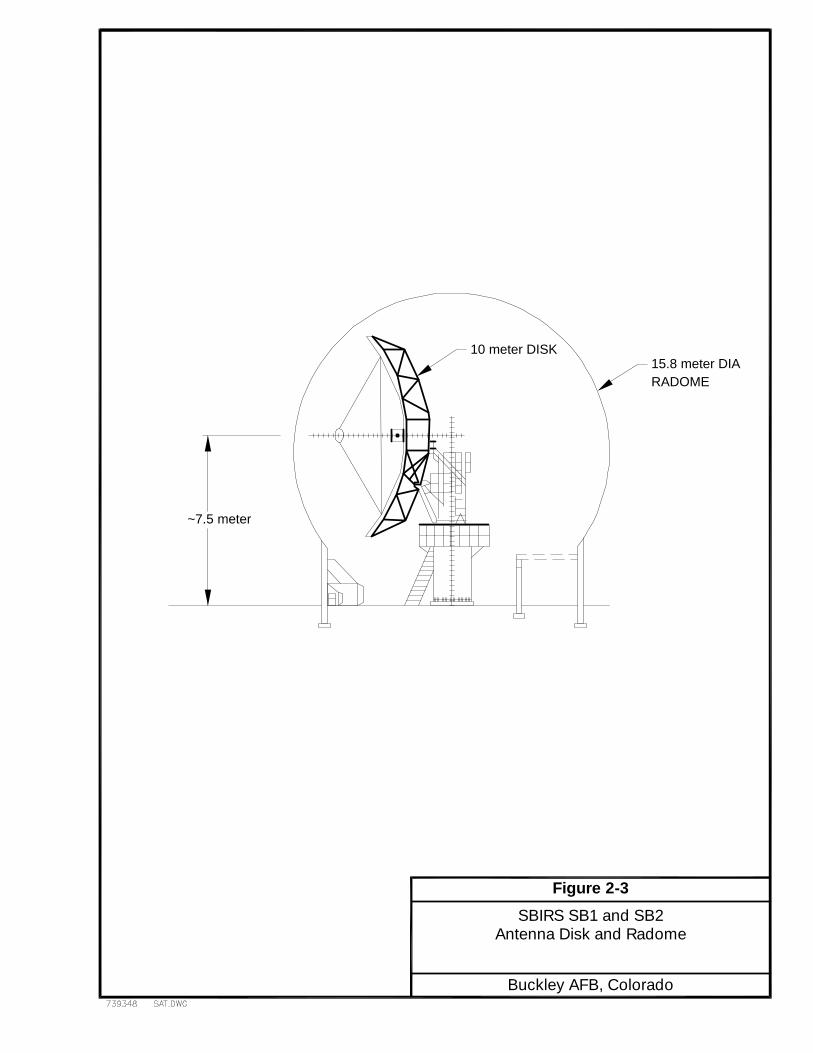
Construction of the two SBIRS antennas and appurtenant structures is anticipated tooccur over a nine month period beginning in mid-FY01. The SBIRS Antenna Subsysteminstallation consists of two antennas, SB1 and SB2. Figure 2-1 depicts the generallocation of the two SBIRS antennas at Buckley AFB. The location of SB1 would beconstructed at coordinates 2202796.72 east and 686155.54 north. SB2 would be locatedat coordinates 2202796.72 east and 686055.54 north. Each 10-meter (33-foot) diameterantennas would be housed within a 15.8-meter (52-foot), air supported radome structurewith related electronic equipment. A site layout of the SBIRS antennas, utilities, andfoundation structures is shown in Figure 2-2. As shown in Figure 2-3, location of theantenna beam center is designed to be approximately 7.5 meters (25-feet) above theantenna base. The antennas and radomes would be installed on concrete foundations andlocated approximately 166 feet west of the center line of Eldora Drive.
The antenna facilities for SB1 and SB2 were designed by the Relay Ground Stationcontractor, Lockheed Martin Corporation. Lockheed Martin would also erect andperform operational performance checks on the SBIRS antennas once constructed.
The foundation centerlines would be located on a north–south line separated byapproximately 100 feet. The reinforced concrete pad foundation for each antennapedestal structure is 10-feet square by 36-inches thick. The concrete slab surrounding theantenna foundation is 6-inches thick from the edges of the pad out to the edges of thecircular radome. The circular walls supporting the outer structure of the radome are 10-feet high and 12-inches thick. A lower equipment room would be constructed inside eachradome, which is 20-feet long by 10-feet wide and 8.5 feet high.

Figure 2-1
Site Location for
Buckley AFB, Colorado
Antennas SB1 and SB2

Description of the Proposed Supplemental Environmental Assessment Action and Alternatives SBIRS MCS for Defense Support Program Consolidation at Buckley AFB, CO
2-4 March 2001
THIS PAGE INTENTIONALLY LEFT BLANK
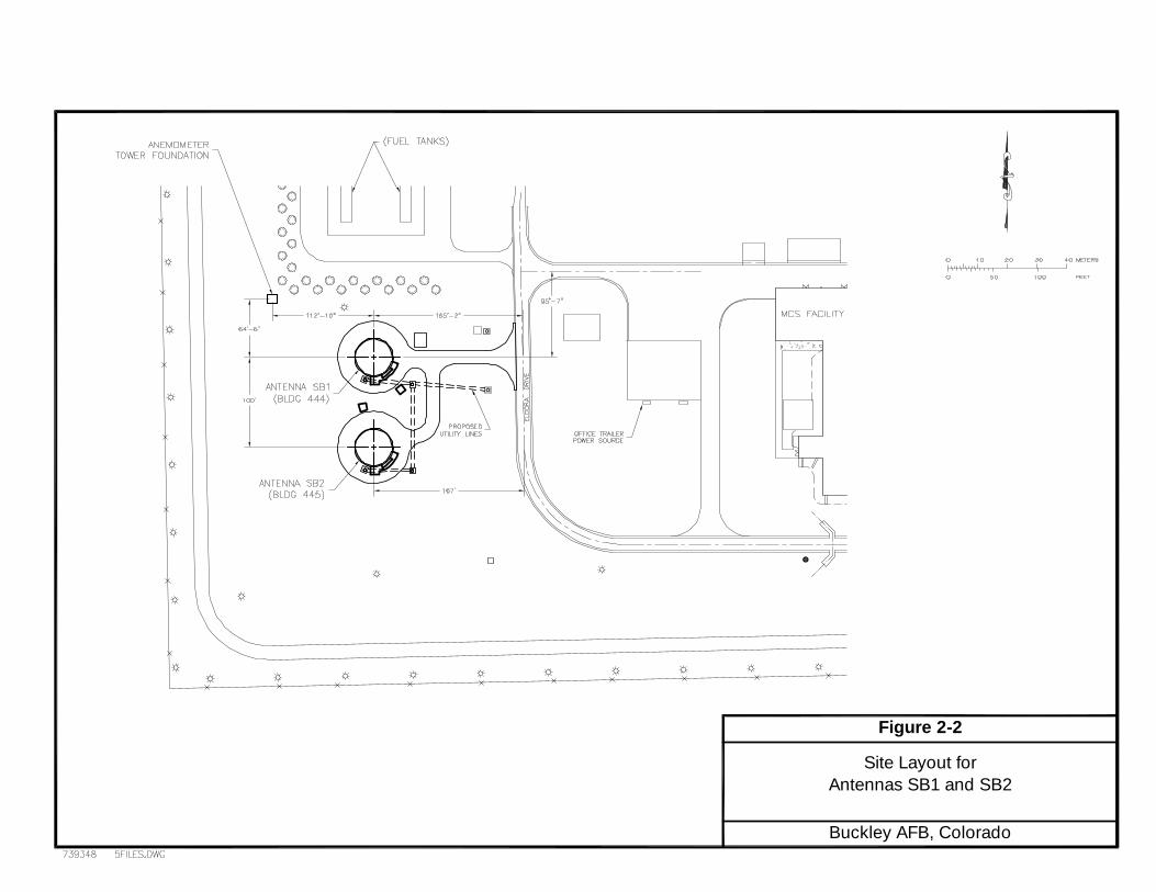
Figure 2-2
Antennas SB1 and SB2
Buckley AFB, Colorado
Site Layout for

Description of the Proposed Supplemental Environmental Assessment Action and Alternatives SBIRS MCS for Defense Support Program Consolidation at Buckley AFB, CO
2-6 March 2001
THIS PAGE INTENTIONALLY LEFT BLANK
15.8 meter DIARADOME
10 meter DISK
~7.5 meter
Antenna Disk and Radome
Buckley AFB, Colorado
SBIRS SB1 and SB2Figure 2-3

Description of the Proposed Supplemental Environmental Assessment Action and Alternatives SBIRS MCS for Defense Support Program Consolidation at Buckley AFB, CO
2-8 March 2001
THIS PAGE INTENTIONALLY LEFT BLANK
Description of the Proposed Supplemental Environmental Assessment Action and Alternatives SBIRS MCS for Defense Support Program Consolidation at Buckley AFB, CO
2-9 March 2001
The area for the proposed antenna site is approximately 400 feet by 400 feet. Accessroads would be constructed from Eldora Drive to SB1 and between SB1 and SB2. A 6-foot by 4-inch thick concrete walkway would be constructed around the outer edges ofeach of the circular foundations. The remaining area for the site would not be coveredwith impervious materials. Surface water drainage would be controlled by storm wateroutlets and diverted away from the foundations. A plan view of the SBIRS antenna diskand radome is shown in Figure 2-3.
Utilities for operating the antennas would include electrical power and natural gas.Maximum power requirements for the antennas would include providing 90 kilovoltamperes (kVA) for SB1 and 60 kVA for SB2. SB1 needs more power because it housesthe equipment that provides positive pressure to keep both radomes inflated.Approximately 1.1 million British thermal units (MBtu) per hour of natural gas for eachantenna would also be required. All external utility interface connections to the antennaswould be constructed underground in concrete vaults. Landscaping to match thesurrounding area would be performed by the base.
Radome auxiliary equipment includes a free standing anemometer set mounted atopa single 30-foot pole, and a single back–up diesel generator. The anemometer would belocated approximately 130 feet northwest of the center of SB1. The anemometer setwould be utilized to determine wind force and speed in order to adjust radome supportingair pressure. The diesel generator would provide emergency power to the radomeinflation blowers in case of a primary power failure. The back-up generator would beplaced on a concrete pad located on the east side of SB1. It is assumed that operationaltesting of the generators would occur for 1 hour per month.
It is anticipated that construction activity would be limited to weekdays only andwould occur between 7:30 a.m. and 4:00 p.m. Occasionally, construction would occur onweekends as needed to meet project completion requirements. There would be no netchange in the number of personnel authorizations at Buckley AFB as a result of theProposed Action.
2.3.3 Antenna Operation
A high efficiency 10-meter diameter reflector would be mounted over the azimuth-axis pedestal. The pedestal provides +/- 160 degrees of azimuth travel from the south and0 to 90 degrees of travel in elevation. The SBIRS antennas would receive data fromsatellite on a continuous basis. The satellites are in geosynchronous orbit; therefore, theantennas would typically point 5 to 10 degrees in elevation and southward betweensoutheast to southwest. The antenna beam centers would be located 25 feet above theantenna base.
Description of the Proposed Supplemental Environmental Assessment Action and Alternatives SBIRS MCS for Defense Support Program Consolidation at Buckley AFB, CO
2-10 March 2001
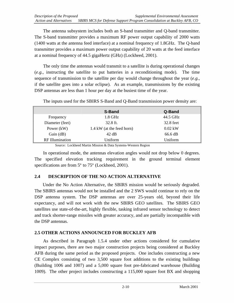
The antenna subsystem includes both an S-band transmitter and Q-band transmitter.The S-band transmitter provides a maximum RF power output capability of 2000 watts(1400 watts at the antenna feed interface) at a nominal frequency of 1.8GHz. The Q-bandtransmitter provides a maximum power output capability of 20 watts at the feed interfaceat a nominal frequency of 44.5 gigaHertz (GHz) (Lockheed, 2001).
The only time the antennas would transmit to a satellite is during operational changes(e.g., instructing the satellite to put batteries in a reconditioning mode). The timesequence of transmission to the satellite per day would change throughout the year (e.g.,if the satellite goes into a solar eclipse). As an example, transmissions by the existingDSP antennas are less than 1 hour per day at the busiest time of the year.
The inputs used for the SBIRS S-Band and Q-Band transmission power density are:
S-Band Q-BandFrequency 1.8 GHz 44.5 GHz
Diameter (feet) 32.8 ft. 32.8 feetPower (kW) 1.4 kW (at the feed horn) 0.02 kWGain (dB) 42 dB 66.6 dB
RF Illumination Uniform UniformSource: Lockheed Martin Mission & Data Systems-Western Region
In operational mode, the antennas elevation angles would not drop below 0 degrees.The specified elevation tracking requirement in the ground terminal elementspecifications are from 5º to 75º (Lockheed, 2001).
2.4 DESCRIPTION OF THE NO ACTION ALTERNATIVE
Under the No Action Alternative, the SBIRS mission would be seriously degraded.The SBIRS antennas would not be installed and the 2 SWS would continue to rely on theDSP antenna system. The DSP antennas are over 25-years old, beyond their lifeexpectancy, and will not work with the new SBIRS GEO satellites. The SBIRS GEOsatellites use state-of-the-art, highly flexible, tasking infrared sensor technology to detectand track shorter-range missiles with greater accuracy, and are partially incompatible withthe DSP antennas.
2.5 OTHER ACTIONS ANNOUNCED FOR BUCKLEY AFB
As described in Paragraph 1.5.4 under other actions considered for cumulativeimpact purposes, there are two major construction projects being considered at BuckleyAFB during the same period as the proposed projects. One includes constructing a newCE Complex consisting of two 3,500 square foot additions to the existing buildings(Building 1006 and 1007) and a 5,000 square foot pre-fabricated warehouse (Building1009). The other project includes constructing a 115,000 square foot BX and shopping
Description of the Proposed Supplemental Environmental Assessment Action and Alternatives SBIRS MCS for Defense Support Program Consolidation at Buckley AFB, CO
2-11 March 2001
mall and a new 70,000 square foot Commissary. These cumulative impacts are furtherdescribed in Section 4, Environmental Consequences, under each resource area.
2.6 COMPARISON OF ENVIRONMENTAL EFFECTS OF ALLALTERNATIVES
Table 2.1 summarizes impacts of the Proposed Action and the No ActionAlternative.
2.7 IDENTIFICATION OF THE PREFERRED ALTERNATIVE
The preferred alternative is to implement the Proposed Action as described inParagraph 2.3 above.
2.8 MITIGATION MEASURES
Mitigation measures would not be necessary for any of the resources analyzed in thisEA. BMPs are routinely implemented to further minimize the potential forenvironmental impacts. These management practices are detailed in Section 4,Environmental Consequences, and summarized in Table 2.2.
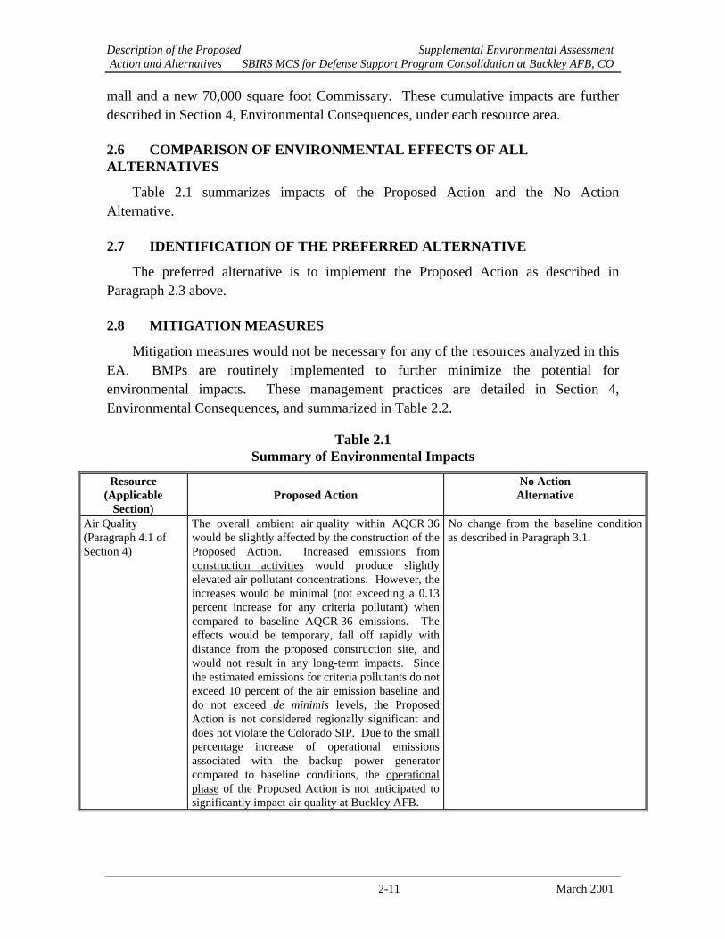
Table 2.1Summary of Environmental Impacts
Resource(Applicable
Section)Proposed Action
No ActionAlternative
Air Quality(Paragraph 4.1 ofSection 4)
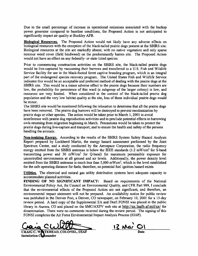
The overall ambient air quality within AQCR 36would be slightly affected by the construction of theProposed Action. Increased emissions fromconstruction activities would produce slightlyelevated air pollutant concentrations. However, theincreases would be minimal (not exceeding a 0.13percent increase for any criteria pollutant) whencompared to baseline AQCR 36 emissions. Theeffects would be temporary, fall off rapidly withdistance from the proposed construction site, andwould not result in any long-term impacts. Sincethe estimated emissions for criteria pollutants do notexceed 10 percent of the air emission baseline anddo not exceed de minimis levels, the ProposedAction is not considered regionally significant anddoes not violate the Colorado SIP. Due to the smallpercentage increase of operational emissionsassociated with the backup power generatorcompared to baseline conditions, the operationalphase of the Proposed Action is not anticipated tosignificantly impact air quality at Buckley AFB.
No change from the baseline conditionas described in Paragraph 3.1.

Description of the Proposed Supplemental Environmental Assessment Action and Alternatives SBIRS MCS for Defense Support Program Consolidation at Buckley AFB, CO
2-12 March 2001
Resource(Applicable
Section)Proposed Action
No ActionAlternative
BiologicalResources(Paragraph 4.2 ofSection 4)
The Proposed Action would not likely have anyadverse effects on biological resources, with theexception of the black-tailed prairie dogs present atthe SBIRS site. Biological resources at the site aremarkedly absent, with no native vegetation and onlysparse noxious weed cover (field bindweed) on thepredominantly barren site. The Proposed Actionwould not have an effect on federally-listed or statespecies. Prior to commencing constructionactivities on the SBIRS site, the black-tailed prairiedogs would be live-captured by vacuuming theirburrows and transferred to a U.S. Fish and WildlifeService facility for use in the black-footed ferretendangered species recovery program. This wouldbe a minor adverse effect because the number ofprairie dogs present is low (likely less than 10individuals), the probability for persistence of thisward (a subgroup of the larger colony) is low, andresources are very limited. The likelihood ofpredation in the open space is high, and because ofthe low number of individuals, it is probable thatthe ward will not persist. When considered in thecontext of the black-tailed prairie dog populationand the very low habitat quality on the site, loss ofthese individual prairie dogs would be minor.
No change from the baseline conditionas described in Paragraph 3.2.
Non-ionizing EnergyParagraph 4.3 ofSection 4)
According to results of the SBIRS System SafetyHazard Analysis Report prepared by LockheedMartin, the radiation hazard assessment preformedby the JSC, and the study conducted by theAerospace Corporation, the RF energy emitted fromthe SBIRS antennas is not expected to have aneffect on human health. Since the power densitylevels emitted from the SBIRS antennas are muchless than the level established for the safe operatingdistance for fuels, no potential fuel ignition hazardexists.
The RF energy emitted as a result of theNo Action Alternative (continued use ofthe existing DSP antennas) is expectedto be similar to the Proposed Action.
Utilities (Paragraph4.4 of Section 4)
The energy consumption rate for the ProposedAction is equivalent to 15 percent of the currentelectricity demand of SBIRS and less than 1 percentof the current base usage rates. Therefore, theProposed Action is not anticipated to negativelyimpact the base electrical distribution system. Theenergy consumption rate for natural gas wouldrepresent approximately 2 percent of the currentSBIRS natural gas usage rate, and less than1 percent of the average annual base usage rate.Therefore, the Proposed Action is not anticipated tonegatively impact the base natural gas distributionsystem.
No change from the baseline conditionas described in Paragraph 3.4.

Description of the Proposed Supplemental Environmental Assessment Action and Alternatives SBIRS MCS for Defense Support Program Consolidation at Buckley AFB, CO
2-13 March 2001
Table 2.2Summary of Best Management Practices
Resource(Applicable Section)
Proposed Action
Air Quality(Paragraph 4.1 of Section 4)
Potential criteria pollutant emissions associated with theProposed Action do not exceed significance criteriarequirements. Therefore, no mitigative measures for improvingthe ambient air quality would be required. Although mitigationis not required, possible BMPs include watering for dustsuppression to control PM10
emissions.
Biological Resources(Paragraph 4.2 of Section 4)
Prior to commencing construction activities on the SBIRS site,the black-tailed prairie dogs would be live-captured byvacuuming their burrows and transferred to a U.S. Fish andWildlife Service facility for use in the black-footed ferretendangered species recovery program. The USFWS hasindicated that this would be an acceptable and preferredmethod to deal with the prairie dogs. This action would beaccomplished by using a vacuum system to remove the animalsfrom their burrows. . The SBIRS site would be monitoredfollowing the prairie dog collection effort to determine that allthe prairie dogs were removed. The prairie dog burrows willbe destroyed to prevent recolonization by prairie dogs or otherspecies.
Non-ionizing Energy(Paragraph 4.3 of Section 4)
No mitigative measures would be required. However, thefollowing safety precautions should be followed: locate RFenergy warning signs on the rear of each reflector petal;establish and mark restrictive areas to prevent personnel fromentering any RF energy hazard area; ensure authorizedpersonnel disable antenna transmissions prior to performingmaintenance; and ensure that antenna lockout and stopprocedures are in place and included in maintenance technicalorders.

Description of the Proposed Supplemental Environmental Assessment Action and Alternatives SBIRS MCS for Defense Support Program Consolidation at Buckley AFB, CO
2-14 March 2001
THIS PAGE INTENTIONALLY LEFT BLANK
Supplemental Environmental AssessmentAffected Environment SBIRS MCS for Defense Support Program Consolidation at Buckley AFB, CO
3-1 March 2001
SECTION 3AFFECTED ENVIRONMENT
This section describes the existing environmental media that could be affected by, orcould affect the Proposed Action and No Action Alternative. Within this context, onlythose base-specific components relevant to the potential impacts are described in detail.Anticipated effects of the Proposed Action and No Action Alternative are discussed inSection 4, Environmental Consequences.
3.1 AIR QUALITY
Buckley AFB is located in Arapahoe County within the Metropolitan DenverIntrastate Air Quality Control Region (AQCR) 36. This AQCR includes the counties ofAdams, Arapahoe, Boulder, Clear Creek, Denver, Douglas, Gilpin, and Jefferson.
For purposes of this air quality analysis, the region of influence (ROI) for criteriapollutant emissions and ozone precursors from the proposed activities would be theexisting air column surrounding Arapahoe County, Colorado. Project emissions ofcriteria pollutants, which are discussed below, are compared to regional emissions todetermine if they are regionally significant. Mobile source emissions from constructionactivities are included as part of the analysis to determine if they contribute to acumulative effect with respect to other construction projects occurring at Buckley AFBduring the same time period.
3.1.1 Air Pollutants and Regulations
Air quality in any given region is measured by the concentration of various pollutantsin the atmosphere, typically expressed in units of parts per million (ppm) or microgramsper cubic meter (µg/m3). Air quality is not only determined by types and quantities ofatmospheric pollutants, but also by surface topography, size of the air basin, and byprevailing meteorological conditions.
The Clean Air Act (CAA) of 1970 directed the USEPA to develop, implement, andenforce strong environmental regulations to ensure cleaner air for all Americans. In orderto protect public health and welfare, the USEPA developed concentration-based standardscalled National Ambient Air Quality Standards (NAAQS). Promulgation of the CAAwas driven by the failure of nearly 100 cities to meet the NAAQS for ozone and carbonmonoxide and by the inherent limitations in previous regulations to effectively deal withthese and other air quality problems. The USEPA established both primary andsecondary NAAQS under provisions of the CAA. Primary standards define levels of air

Supplemental Environmental AssessmentAffected Environment SBIRS MCS for Defense Support Program Consolidation at Buckley AFB, CO
3-2 March 2001
quality necessary to protect public health with an adequate margin of safety. Secondarystandards define levels of air quality necessary to protect public welfare (e.g., soils,vegetation, property, and wildlife) from any known or anticipated adverse effects.
NAAQS are currently established for six air pollutants (known as “criteria airpollutants”) including carbon monoxide (CO), nitrogen dioxide (NO2), ozone (O3), sulfuroxides (SOx, measured as sulfur dioxide, SO2), lead (Pb), and particulate matter.Particulate matter standards incorporate two particulate classes: 1) particulate matterwith an aerodynamic diameter less than or equal to 10 micrometers (PM10); and2) particulate matter with an aerodynamic diameter less than or equal to 2.5 micrometers(PM2.5). Only PM10 is regulated by the rule.
SO2 in the atmosphere is converted to various conjugated sulfur compounds whichform physically harmful vapors or micro droplets (e.g., sulfuric acid) when combinedwith particulate matter and water. Most SOx compounds are irritants to the upperrespiratory tract, and prolonged exposure can cause permanent lung damage. In addition,suspended SOx compounds in the atmosphere scatter visible light resulting in a brownishhaze and reduced visibility.
Although O3 is considered one of the criteria air pollutants and is measurable in theatmosphere, it is considered a secondary pollutant since O3 is typically not emitteddirectly from most emissions sources. O3 is formed in the atmosphere by photochemicalreactions involving previously emitted pollutants or ozone precursors; therefore, O3 is notconsidered when calculating emissions. Ozone precursors consist primarily of nitrogenoxides (NOX) and volatile organic compounds (VOCs) which are directly emitted fromvarious emission sources. For this reason, an attempt is made to control O3 through thecontrol of NOX and VOCs. On June 5, 1998 the USEPA issued the final rule identifyingareas, which included Buckley AFB, where the 1-hour NAAQS for O3 is no longerapplicable. Under this rule, the 1-hour standard will not apply to areas in which noviolation of the previous 1-hour ozone standards occurred. However, in areas in whichpast violations occurred, the 1-hour ozone standard will continue to apply.
The CAA does not make the NAAQS directly enforceable. However, the CAA doesrequire each state to promulgate a state implementation plan (SIP) to provide for“implementation, maintenance, and enforcement” of the NAAQS in each air qualitycontrol region (AQCR) in the state. The CAA also allows states to adopt air qualitystandards that are more stringent than federal standards. As promulgated in the ColoradoAir Quality Control Commission (AQCC) Regulation 11, as amended, the State ofColorado has adopted the NAAQS as the Colorado standard. (see Table 3.1-1).

Supplemental Environmental AssessmentAffected Environment SBIRS MCS for Defense Support Program Consolidation at Buckley AFB, CO
3-3 March 2001
Concerns of this AQCC with regard to the low odor threshold and conflictinginformation regarding possible effects of long-term exposure on human health andagriculture led to the adoption of ambient air standards of SO2 more restrictive than theUSEPA primary and secondary standards. Table 3.1-2 presents the State of Coloradostandards. The following ambient standards for SO2 are expressed as allowable amountsof increase in ambient concentration (increments) over an established baseline. Allconcentrations are expressed in micrograms per actual cubic meter under local conditionsof temperature and pressure.
Table 3.1-1 National and State Ambient Air Quality Standards*
CriteriaPollutant
AveragingTime
PrimaryNAAQSa,b,c
SecondaryNAAQSa,b,d
ColoradoStandardsa,b
CarbonMonoxide
8-hour1-hour
9 ppm (10 mg/m3)35 ppm (40 mg/m3)
No standardNo standard
9 ppm (10 mg/m3)35 ppm (40 mg/m3)
Lead Quarterly 1.5 µg/m3 1.5 µg/m3 NA
NitrogenDioxide
Annual 0.0543 ppm (100 µg/m3)
0.0543 ppm (100 µg/m3)
0.0543 ppm (100 µg/m3)
Ozone 1 hour 0.12 ppm (235 µg/m3) 0.12 ppm (235 µg/m3) 0.12 ppm (235 µg/m3)
PM10 Annual24-hour
50 µg/m3
150 µg/m350 µg/m3
150 µg/m350 µg/m3
150 µg/m3
Sulfur Oxides(measured asSO2)
Annual24-hour3-hour
0.03 ppm (80 µg/m3)0.14 ppm (365 µg/m3)
No standard
No standardNo standard
0.50 ppm (1,300 µg/m3)
See Table 3.1-2
* Revised on March 16, 2000, effective as of May 30, 2000.
PM10 Particles with aerodynamic diameters less than or equal to a nominal 10 micrometersa The 8-hour primary and secondary ambient air quality standards are met at a monitoring site when the
average of the annual fourth-highest daily maximum 8-hour average ozone concentration is less than orequal to 0.08ppm.
b The NAAQS and Colorado standards are based on standard temperature and pressure of 25 degrees Celsiusand 760 millimeters of mercury.
c National Primary Standards: The levels of air quality necessary to protect the public health with anadequate margin of safety. Each state must attain the primary standards no later than three years after thestate implementation plan is approved by the USEPA.
d National Secondary Standards: The levels of air quality necessary to protect the public welfare from anyknown or anticipated adverse effects of a pollutant. Each state must attain the secondary standards within a“reasonable time” after the state implementation plan is approved by the USEPA.
Supplemental Environmental AssessmentAffected Environment SBIRS MCS for Defense Support Program Consolidation at Buckley AFB, CO
3-4 March 2001
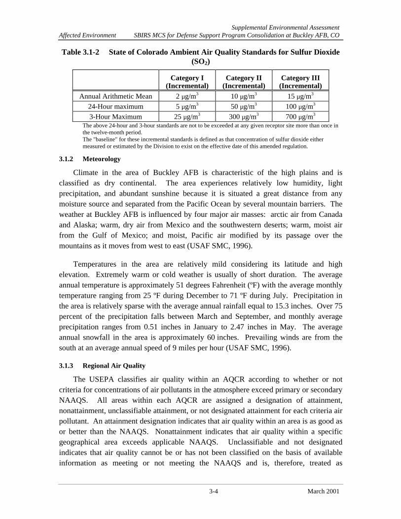
Table 3.1-2 State of Colorado Ambient Air Quality Standards for Sulfur Dioxide(SO2)
Category I(Incremental)
Category II(Incremental)
Category III(Incremental)
Annual Arithmetic Mean 2 µg/m3 10 µg/m3 15 µg/m3
24-Hour maximum 5 µg/m3 50 µg/m3 100 µg/m3
3-Hour Maximum 25 µg/m3 300 µg/m3 700 µg/m3
The above 24-hour and 3-hour standards are not to be exceeded at any given receptor site more than once inthe twelve-month period.The "baseline" for these incremental standards is defined as that concentration of sulfur dioxide eithermeasured or estimated by the Division to exist on the effective date of this amended regulation.
3.1.2 Meteorology
Climate in the area of Buckley AFB is characteristic of the high plains and isclassified as dry continental. The area experiences relatively low humidity, lightprecipitation, and abundant sunshine because it is situated a great distance from anymoisture source and separated from the Pacific Ocean by several mountain barriers. Theweather at Buckley AFB is influenced by four major air masses: arctic air from Canadaand Alaska; warm, dry air from Mexico and the southwestern deserts; warm, moist airfrom the Gulf of Mexico; and moist, Pacific air modified by its passage over themountains as it moves from west to east (USAF SMC, 1996).
Temperatures in the area are relatively mild considering its latitude and highelevation. Extremely warm or cold weather is usually of short duration. The averageannual temperature is approximately 51 degrees Fahrenheit (ºF) with the average monthlytemperature ranging from 25 ºF during December to 71 ºF during July. Precipitation inthe area is relatively sparse with the average annual rainfall equal to 15.3 inches. Over 75percent of the precipitation falls between March and September, and monthly averageprecipitation ranges from 0.51 inches in January to 2.47 inches in May. The averageannual snowfall in the area is approximately 60 inches. Prevailing winds are from thesouth at an average annual speed of 9 miles per hour (USAF SMC, 1996).
3.1.3 Regional Air Quality
The USEPA classifies air quality within an AQCR according to whether or notcriteria for concentrations of air pollutants in the atmosphere exceed primary or secondaryNAAQS. All areas within each AQCR are assigned a designation of attainment,nonattainment, unclassifiable attainment, or not designated attainment for each criteria airpollutant. An attainment designation indicates that air quality within an area is as good asor better than the NAAQS. Nonattainment indicates that air quality within a specificgeographical area exceeds applicable NAAQS. Unclassifiable and not designatedindicates that air quality cannot be or has not been classified on the basis of availableinformation as meeting or not meeting the NAAQS and is, therefore, treated as

Supplemental Environmental AssessmentAffected Environment SBIRS MCS for Defense Support Program Consolidation at Buckley AFB, CO
3-5 March 2001
attainment. Before a nonattainment area is eligible for reclassification to attainmentstatus, the state must demonstrate compliance with NAAQS in the nonattainment area forthree consecutive years and demonstrate, through extensive dispersion modeling, thatattainment status can be maintained in the future even with community growth.
States with nonattainment areas submit a SIP for USEPA approval. The SIPdescribes how the state will bring all nonattainment areas into attainment with theNAAQS by imposing controls on sources of air pollution. For example, areas that are innonattainment for carbon dioxide have control requirements that vary in stringencyaccording to classification: moderate or serious.
The Colorado Air Pollution Control Division has authority to implement regulationscontained in the Colorado Air Pollution Prevention and Control Act, Section 25-7-105(1)(a), requiring AQCR 36 to assure attainment and maintenance of NAAQS bypromulgating applicable sections of a SIP. As part of the SIP, Colorado has incorporatedthe General Conformity Rule. The USEPA Conformity Rule, 40 CFR 93, subpart B, and40 CFR 51, subpart W, implements Section 176(c) of the CAA, as amended in 42 UnitedStates Code [USC] 7506(c). Conformity to the SIP is defined in the CAA as requiring allfederal agencies to ensure that any agency activity conforms to an approved SIP innonattainment or maintenance areas. Compliance with the SIP assists with eliminating orreducing the number of violations or severity with the NAAQS, which expeditesattainment of the standards. The USAF is responsible for determining if the proposedactivities at Buckley AFB conform to the SIP.
The USEPA Conformity Rule requires that the total direct and indirect emissions ofnonattainment criteria pollutants, including O3 precursors (VOC and NOx) be consideredin determining conformity. The rule does not apply to actions where the total direct andindirect emissions do not exceed de minimis threshold levels for criteria pollutantsestablished in 40 CFR 93.135(b). In addition to meeting de minimis requirements, afederal action may be considered regionally significant. Regional significance is definedby a total of direct and indirect emissions resulting from a federal agency action thatequals or exceeds 10 percent of the nonattainment area’s emissions inventory for anycriteria pollutant.
The Denver metropolitan area where Buckley AFB is located is part of an area that isin nonattainment for CO. Carbon monoxide is a colorless, odorless, poisonous gas thatcan threaten those who suffer from cardiovascular disease. Carbon monoxide emissionsin the Denver area are produced mostly by automotive sources resulting from theincomplete combustion of fuel.
Supplemental Environmental AssessmentAffected Environment SBIRS MCS for Defense Support Program Consolidation at Buckley AFB, CO
3-6 March 2001
The Denver metropolitan area has also been designated as a PM10 nonattainment areasince 1987, but has not violated this 24-hour PM10 standard since 1993. Therefore, thearea is now eligible for redesignation. The State of Colorado, in coordination with theRegional Air Quality Council (RAQC), is requesting that the USEPA redesignate theDenver metropolitan nonattainment area to attainment status for the 24-hour PM10
National Ambient Air Quality Standard. The PM-10 Redesignation Request andMaintenance Plan For the Denver Metropolitan Area was approved by the RAQC andthe Colorado Air Quality Control Commission (AQCC) on December 13, 2000, and isnow pending federal review (RAQC, 2000). Particulate matter of small size, less than 10microns, can be inhaled into the respiratory system and cause aggravation of existingrespiratory disease and a decline in lung function. Particulate matter is emitted into theair by industrial sources, construction activities, diesel fuels, and natural sources (e.g.,wind-blown dust).
The Colorado Department of Public Health and the Environment (CDPHE), 1995 AirQuality Data Report, indicated that CO levels have dropped at every monitoring stationduring the last 10 years. In 1985, there were 31 days with one or more monitors readingan exceedance of the 8-hour standard. Most of the exceedance day readings were fromthe Denver Metropolitan area. In Denver, it is estimated that 86 percent of CO emissionsare from automotive sources. The relationship between motor vehicle emissions and COlevels has been identified as daily concentration peaks that coincide with morning andevening rush hours. The worse CO problems occur where numerous slow-moving carscongregate, such as in large parking lots and traffic jams. CO is more severe in winterdue to naturally occurring inversion layers (USAF, 2000).
Major sources of pollution in AQCR 36 include power plants, oil refineries, gasolinestorage terminals and transfer stations, mining activities, chemical plants, cement plants,and various agricultural operations (USAF, 2000).
De minimis thresholds are dependent upon the regional air quality classification.Due to its classification as moderately nonattainment for PM10 and severelynonattainment for carbon monoxide, the Denver metropolitan area de minimis thresholdsare 100 tons per year for both pollutants. Ongoing activities currently being conductedare exempt from the Conformity Rule as long as there is no increase in emissions abovethe specified de minimis threshold levels.
3.1.4 Baseline Air Emissions
Baseline conditions for air quality associated with stationary emissions sources areFY99 emissions inventory data. An air emissions inventory is an estimate of total massemission of pollutants generated from a source or sources over a period of time, typicallya year. All emission sources may be categorized as either mobile or stationary emission

Supplemental Environmental AssessmentAffected Environment SBIRS MCS for Defense Support Program Consolidation at Buckley AFB, CO
3-7 March 2001
sources. Mobile sources typically include aircraft, surface vehicles, aerospace groundequipment, and weapons testing, whereas stationary sources may include boilers,generators, fueling operations, industrial processes, and burning activities, among others.Accurate air emissions inventories are needed for estimating the relationship betweenemissions sources and air quality. The FY99 air emissions inventory summary forBuckley AFB and AQCR 36 as well as the de minimis levels are presented in Table 3.1-3.The emissions inventory represents air emissions from combustion sources and fuelstorage/transfer operations.
Table 3.1-3 Emissions Inventory for the Buckley AFB
Emission Source Totals (tons/yr) CO VOC NOX SOX PM10
FY 99 Buckley AFB Stationary Emissiona 19.4 10.3 81.2 11.8 2.15
FY 99 Buckley AFB Mobile Emissionsb 375 247 119 7.68 3.30
Conformity Rule De Minimis Thresholdb 100 NA NA NA 100
1998 AQCR 36 Emission Inventoryb 4,761 13,727 37,079 34,732 3,211
a Source: Sherva, 2001ab Source: ANG, 1999NA Not Applicable
Buckley AFB has a current Title V operating permit that includes all existingsources. New sources would be included, as applicable, as a Title V permit modification.Construction of new or modified stationary sources that are not exempt sources atBuckley AFB are subject to current permitting requirements and control technologystandards until the reclassifications are effective. These requirements review airemissions to ensure that sources are constructed and operated without contributingsignificant adverse deterioration of nonattainment air quality standards (USAF, 2000).
3.2 BIOLOGICAL RESOURCES
Biological resources include native and introduced plants and animals in the projectarea. For discussion purposes, these are divided into vegetation, wildlife, sensitivespecies, and sensitive habitats. The ROI for discussion of biological resources andpotential impacts on these resources is Buckley AFB.
Numerous studies have been conducted for biological resources on and aroundBuckley AFB. These studies include the EA of Proposed Prairie Dog ManagementPractices at Buckley AFB (ANG, 2000), biological resource descriptions found in theBase Master Plan, the environmental considerations report for the bombing and gunneryranges, and the archives search report findings conducted for the base. The USFWSNational Wetlands Inventory (NWI) was used to provide information about wetland

Supplemental Environmental AssessmentAffected Environment SBIRS MCS for Defense Support Program Consolidation at Buckley AFB, CO
3-8 March 2001
locations. The Colorado Division of Wildlife (CDOW) has species distribution results(including state listed and sensitive species) available for reptiles, amphibians, mammals,and birds, along with a data system containing element occurrence records (CDOW,2001). The USFWS publishes a current list of threatened and endangered species on theUFSWS web site (FWS, 2001a and b). All these data sources were used in thedevelopment of the biological section of this supplemental EA.
Buckley AFB lies within the dry domain, central high plains ecological sub-region.The base is within the lowlands of the South Platte River. Areas to the north, south, andeast are largely undeveloped and support grazing and farming activities. Areas to thewest are mostly urbanized. Historically, the native climax vegetation for the region wasprimarily mixed bunchgrass prairie (ANG, 1998).
3.2.1 Vegetation and Wildlife
Buckley AFB lies in the plains grassland ecosystem that is composed of a patchworkof grass communities. The dominant habitat type on base is the crested wheatgrass(Agropyron cristatum) community. Midgrass prairie is dominant in the southern portionof the base, and contains species such as western wheatgrass (Agropyron smithii) (ANG,1998).
Biological resources at the proposed SBIRS site are extremely limited. The groundis predominantly bare earth, with less than 5 percent vegetative cover. The limitedvegetative cover that does exist is dominated by field bindweed (Convolvulus arvensis),an exotic noxious weed. Adjacent lands to the east and south are landscaped with2 to 4 inches of rock, with no vegetation present. A row of landscaped evergreen trees,surrounded by rock landscaping, is north of the site. The western side of the site isbounded by a paved road with an open field further to the west.
Wildlife habitats on the base include urban landscape, grassland, midgrass prairie,riparian (including open meadows and trees along the streams), ornamental tree stands,weedy forbs, and yucca stands. A total of seven amphibian and 19 reptile species occurin Arapahoe County and may occur on Buckley AFB (ANG, 1998). Twelve of the reptilespecies are snakes, including the bull snake (Pituophis melanoleucus), plains hognosesnake (Heterodon nasicus nasicus), and the prairie rattlesnake (Crotalus viridis viridis).Other common reptiles include the western painted turtle (Chrysemys picta belli) and thenorthern prairie lizard (Sceloporus undulatus garmani). The great plains toad (Bufocognatus) and plains spadefoot toad (Scaphiopus bombifrons) are among the amphibiansthat may be found at the base. Refer to the Buckley ANGB EA for the Construction of aBX and Commissary (ANG, 1998) for a list of wildlife and plants with the potential tooccur on Buckley AFB. All migratory native North American birds, their eggs, and nestsare protected by the Migratory Bird Treaty Act (MBTA) of 1912, as amended. Resident

Supplemental Environmental AssessmentAffected Environment SBIRS MCS for Defense Support Program Consolidation at Buckley AFB, CO
3-9 March 2001
bird species that occur near Buckley AFB include the western meadowlark (Sturnellaneglecta), horned lark (Eremophila alpestris), and lark bunting (Calamospizamelanocorys). Raptors found in the area include the burrowing owl (Athene cunicularia),American kestrel (Falco sparverius), Swainson's hawk (Buteo swainsoni), and prairiefalcon (Falco mexicanus). The wetland and riparian areas on base support ducks andgeese, including northern shoveler (Anas clypeata), blue-winged teal (Anas discors), andCanada goose (Branta canadensis).
A number of small mammals exist on Buckley AFB. Common rodents include foxsquirrel (Sciurus niger), thirteen-lined ground squirrel (Spermophilus tridecemlineatus),prairie vole (Microtus ochrogaster), black-tailed prairie dog (Cynomys ludovicianus), andseveral species of mice (Peromyscus spp.).
Mammalian predators on base include the red fox (Vulpes vulpes), badger (Taxideataxus), and coyote (Canis latrans). White-tailed deer (Odocoileus virginianus), muledeer (Odocoileus hemionus), and pronghorn (Antilocapra americana) are among thelarger herbivores on base. Pronghorn occurring on the base have been excluded fromselected areas by an exterior fence to prevent collision hazards with aircraft (ANG, 1998).
3.2.2 Threatened, Endangered and Special Concern Species
A number of sensitive species have potential to occur on base. These species, withtheir respective federal and state status, are listed in Table 3.2.1.
Table 3.2.1 Sensitive Species Occurring or PotentiallyOccurring on Buckley AFB
Common Name Scientific Name Status
PlantsColorado butterfly plant Gaura neomexicana ssp. coloradensis FT, S1
Ute ladies'-tresses Spiranthes diluvialis FT, S2
AmphibiansNorthern leopard frog Rana pipiens SSC
BirdsBald eagle Haliaeetus leucocephalus FT, ST
Mountain plover Charadrius montanus FPT, SSC
Plains sharp-tailed grouse Tympanuchus phasianellus jamesii SE
Western burrowing owl Athene cunicularia ST
Ferruginous hawk Buteo regalis SSC
MammalsBlack-footed ferret Mustela nigripes FE, SE
Preble's meadow jumping mouse Zapus hudsonius preblei FT, ST
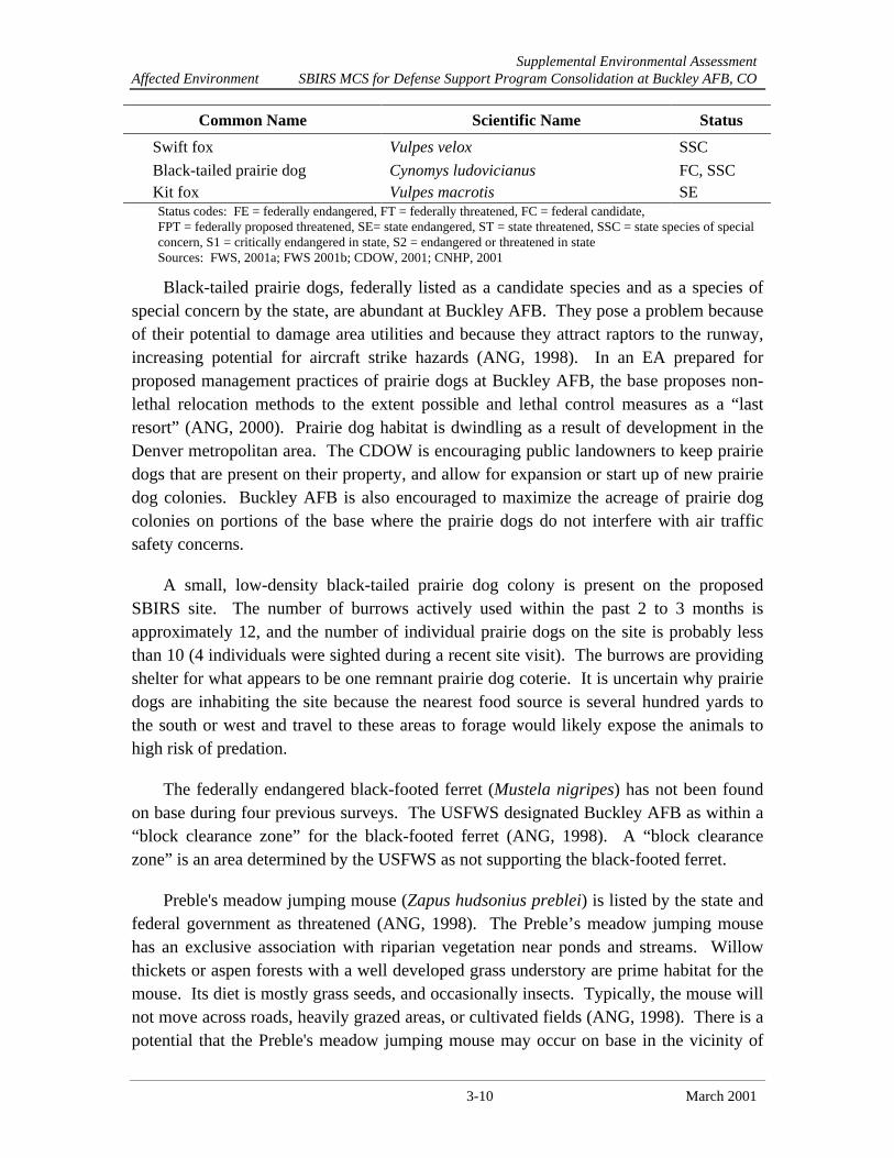
Supplemental Environmental AssessmentAffected Environment SBIRS MCS for Defense Support Program Consolidation at Buckley AFB, CO
3-10 March 2001
Common Name Scientific Name Status
Swift fox Vulpes velox SSC
Black-tailed prairie dog Cynomys ludovicianus FC, SSCKit fox Vulpes macrotis SEStatus codes: FE = federally endangered, FT = federally threatened, FC = federal candidate,FPT = federally proposed threatened, SE= state endangered, ST = state threatened, SSC = state species of specialconcern, S1 = critically endangered in state, S2 = endangered or threatened in stateSources: FWS, 2001a; FWS 2001b; CDOW, 2001; CNHP, 2001
Black-tailed prairie dogs, federally listed as a candidate species and as a species ofspecial concern by the state, are abundant at Buckley AFB. They pose a problem becauseof their potential to damage area utilities and because they attract raptors to the runway,increasing potential for aircraft strike hazards (ANG, 1998). In an EA prepared forproposed management practices of prairie dogs at Buckley AFB, the base proposes non-lethal relocation methods to the extent possible and lethal control measures as a “lastresort” (ANG, 2000). Prairie dog habitat is dwindling as a result of development in theDenver metropolitan area. The CDOW is encouraging public landowners to keep prairiedogs that are present on their property, and allow for expansion or start up of new prairiedog colonies. Buckley AFB is also encouraged to maximize the acreage of prairie dogcolonies on portions of the base where the prairie dogs do not interfere with air trafficsafety concerns.
A small, low-density black-tailed prairie dog colony is present on the proposedSBIRS site. The number of burrows actively used within the past 2 to 3 months isapproximately 12, and the number of individual prairie dogs on the site is probably lessthan 10 (4 individuals were sighted during a recent site visit). The burrows are providingshelter for what appears to be one remnant prairie dog coterie. It is uncertain why prairiedogs are inhabiting the site because the nearest food source is several hundred yards tothe south or west and travel to these areas to forage would likely expose the animals tohigh risk of predation.
The federally endangered black-footed ferret (Mustela nigripes) has not been foundon base during four previous surveys. The USFWS designated Buckley AFB as within a“block clearance zone” for the black-footed ferret (ANG, 1998). A “block clearancezone” is an area determined by the USFWS as not supporting the black-footed ferret.
Preble's meadow jumping mouse (Zapus hudsonius preblei) is listed by the state andfederal government as threatened (ANG, 1998). The Preble’s meadow jumping mousehas an exclusive association with riparian vegetation near ponds and streams. Willowthickets or aspen forests with a well developed grass understory are prime habitat for themouse. Its diet is mostly grass seeds, and occasionally insects. Typically, the mouse willnot move across roads, heavily grazed areas, or cultivated fields (ANG, 1998). There is apotential that the Preble's meadow jumping mouse may occur on base in the vicinity of
Supplemental Environmental AssessmentAffected Environment SBIRS MCS for Defense Support Program Consolidation at Buckley AFB, CO
3-11 March 2001
the creeks. A survey for rare or imperiled species and significant natural communities,conducted by the Colorado Natural Heritage Program on Buckley AFB in June 2000,specifically searched for Prebles meadow jumping mice and none were found onbase(CNHP, 2000).
The swift fox (Vulpes velox), a small nocturnal fox, is a state species of specialconcern and prefers short to mid-grass prairie habitat. It is found in association withprairie dogs that, along with other small vertebrates, comprise about 75 percent of thefox's diet (ANG, 1998). The swift fox has not yet been identified as occurring on thebase.
The bald eagle (Haliaeetus leucocephalus), federally listed as threatened, occursaround lakes and rivers in the winter. It typically forages for fish, but is also known totake small mammals, including prairie dogs. Generally, winter habitat preferences for thebald eagle include a readily available food source associated with ice-free waters, diurnalperches, nocturnal roost trees, and low human activity. The bald eagle is a transientvisitor to Buckley AFB in the winter and is not known to breed in the immediate vicinity(ANG,1998). The ferruginous hawk (Buteo regalis), a state special concern species, isfairly common in Arapahoe County (ANG, 1998). It feeds almost exclusively on smallmammals, including prairie dogs, and primarily nests in trees (ANG, 1998). Ferruginoushawks are resident on the adjacent Prairie Conservation Center property and are likely tobe present on Buckley AFB.
The mountain plover (Charadrius montanus), is a candidate species for federallisting. The plover prefers open, arid lands that support short grasses, such asbuffalograss and blue grama, and scattered cactus on the eastern plains of Colorado. Theplover's reported range ends near the eastern boundary of Arapahoe County, and they areunlikely to occur on Buckley AFB (ANG, 1998).
The burrowing owl (Athene cunicularia), a state-threatened species, is known tooccur on base. Burrowing owls are typically present in the area from early March to lateOctober and migrate out of state during the winter months. Burrowing owls typicallyoccur in active prairie dog towns and may be present in recently abandoned prairie dogtowns (ANG, 1998). The 1999 Buckley ANG Integrated Natural Resources ManagementPlan recommended establishing a critical habitat in the southwestern, undeveloped part ofthe base to protect the owl.
Ute ladies'-tresses, (Spiranthes diluvialis), federally listed as threatened, is an orchidfound in seasonally moist soils and wet meadows near springs, lakes, or perennial streamsand their associated floodplains below 6,500 feet in elevation. According to the ColoradoNatural Heritage Program (CNHP), current distribution of the orchid does not include

Supplemental Environmental AssessmentAffected Environment SBIRS MCS for Defense Support Program Consolidation at Buckley AFB, CO
3-12 March 2001
Arapahoe County. Although on-base surveys for the orchid are limited, the only potentialhabitat would be along the creeks.
The Colorado butterfly plant (Gaura neomexicana ssp. coloradensis), federally listedas threatened, prefers alluvial soils of drainage bottoms surrounded by mixed grassprairie, typically at elevations between 5,800 and 6,200 feet. According to the CNHP,current distribution of the Colorado butterfly weed includes wetland areas of ArapahoeCounty. This species could occur along the creeks on the base.
3.2.3 Sensitive Habitat
Sensitive habitats are those areas considered for protection due to their ecologicalvalue. They include wetlands, critical habitat for protected species, plant communities oflimited or unusual distribution, and important seasonal use areas for wildlife. Wetlandsand prairie dog colonies are the only sensitive habitats known on Buckley AFB. A totalof six potential wetlands are located on base according to the NWI maps. Other areasrequire wetland evaluation to determine if they qualify for wetland protection underSection 404 of the Clean Water Act. These areas are found along the riparian corridorsand are currently designated as bottomland meadow or cottonwood/willow association.
3.3 NON-IONIZING ENERGY
Non-ionizing energy is electromagnetic energy emitted at wavelengths whose photonenergy is not high enough to ionize or “charge” an absorbing molecule (i.e., humantissue). Non-ionizing energy is considered to be that part of the electromagnetic energyspectrum with wavelengths greater than 10-7 (0.0000007) meters and consists primarilyof near ultraviolet energy, visible energy or light, infrared energy, and RF energy. RFenergy accounts for the largest range of frequencies among the various types of non-ionizing energy and is used extensively to transmit radio, television, and radar signals.RF energy has a frequency range of 10 kiloHertz (kHz) to 300 GHz.
The ROI for discussion of non-ionizing energy includes Buckley AFB and adjacentproperties off-base.
3.3.1 Health and Safety
Numerous RF energy sources exist throughout Buckley AFB. These are typically inthe form of transmitting antennas which support various space programs. An energyhazard exists when there is sufficient power contained in the incident energy to causedamage to humans. Energy hazard standards are in the form of permissible exposurelevels (PELs). PELs are the exposure level expressed in electric field, magnetic field, orplane wave (far field) power density in milliwatts per square centimeter to which anindividual may be repeatedly exposed and which, under conditions of exposure, will not

Supplemental Environmental AssessmentAffected Environment SBIRS MCS for Defense Support Program Consolidation at Buckley AFB, CO
3-13 March 2001
cause detectable bodily injury regardless of age, sex, or child-bearing status. Thebiological effects of RF energy depend on the frequency of the incident energy field, thepolarization of the field, and the size and shape of the person and his or her ability todissipate, by normal biological mechanisms, the energy absorbed. PELs are used todetermine “safe distances” from RF sources beyond which RF energy hazards will notoccur. PELs for human exposure to RF energy are established in Institute of Electricaland Electronics Engineers (IEEE) Standard C95.1-1991 (IEEE, 1992). The IEEEstandard is recognized as an American National Standard by the American NationalStandards Institute. The USAF has established PELs for similar RF fields in Air ForceOccupational Safety and Health (AFOSH) Standard 48-9.
RF energy is generated by satellite communications equipment located within the 2SWS facility at Buckley AFB. Antennas currently located on Buckley AFB produce RFenergy during operation of the DSP fly-out satellite missions. Additionally, theAerospace Data Facility (ADF) uses various antennas that also produce RF energy. TheADF and its antennas are located north of the MCS facility. Exposures to RF energy cancause hazards to personnel, as discussed above, flammable liquids, and electro-explosivedevices (ANG, 1995).
An Electromagnetic Energy Hazard Survey was conducted in 1990 of the two main2 SWS antennas (DSP antennas, DB1 and DB2) and the survey found there were no RFhazards to electro-explosive devices on the flight line or parking apron, or to transientaircraft. The survey also found that no RF hazards to personnel exist at ground level, orat heights up to 40 feet above the ground. Above that height, RF hazards to personnelmay exist. For this reason, building height restrictions of 40 feet are imposed on facilitiesat the base. Buildings constructed in expansion areas of 2 SWS cannot exceed 5,550 feetabove mean sea level (ANG, 1995). More recent information concerning potential RFhazards above this height suggests that the RF levels at all ground and air levels areexpected to be within acceptable levels (See Appendix B).
The study also concluded that under normal operations, there were no RF hazards tofuel operations, including those at the base fuel farm located just west of the southwestcorner of the outer perimeter fence (ANG, 1995).
3.3.2 Airspace
Buckley AFB is the headquarters for the Colorado ANG and provides the trainingsite for the 140th Fighter Wing of the ANG which operates F-16 aircraft. The 200th AirliftSquadron, another ANG unit, operates several T-43s and C-26 aircraft. The 2nd Battalion,135th Aviation, an Army National Guard unit, operates attack, observation, and utilityhelicopters. The base also provides aircraft search and rescue and crash response for adesignated geographical area in the mid to western portion of the United States.

Supplemental Environmental AssessmentAffected Environment SBIRS MCS for Defense Support Program Consolidation at Buckley AFB, CO
3-14 March 2001
Airspace in and around the Denver metropolitan area, including Buckley AFB, isextremely congested. The airfield at Buckley AFB is 11,000 feet long and is orientated ina northwest by southeast direction. Aircraft departing the base are required to turn leftafter reaching their departure altitude. Air traffic patterns are such that aircraft arerestricted from flying directly over or in the general vicinity of the radomes located at 2SWS or the ADF facilities (Ortega, 2001).
3.4 UTILITIES
The utility systems discussed in this section include electricity and natural gas. TheROI for these utility systems include the service area for each utility that serves theproject site. The major attributes of these utility systems in the ROI are average daily ormonthly demand. These factors are used in determining whether the existing utilitysystems are capable and adequate to provide services.
3.4.1 Electricity
Excel Energy (formerly Public Service Company of Colorado) provides electricity toBuckley AFB. The Excel Energy East Substation, located at the intersection of ColfaxAvenue and I-225, provides electrical power to Buckley AFB through 13.2 kilovoltoverhead distribution lines. Six metering points serve various areas of Buckley ANGB,which is the largest user of power from this substation.
During FY00, the tenant facilities at Buckley AFB used an average of 8,374,511 -kilowatt hours per month. Of this, SBIRS averaged 353,818 kilowatt hours per month, or4 percent of the base usage (Tipton, 2001).
3.4.2 Natural Gas
Natural gas is provided to Buckley AFB by Excel Energy through a 4-inch gas mainbeneath 6th Avenue (ANG, 1998). The regional natural gas system has a capacity of 130billion cubic feet (ANG, 1999). The average FY00 demand is 228,363.30 therms permonth, or 22,836 million BTUs per month (Tipton, 2001).
Environmental Supplemental Environmental AssessmentConsequences SBIRS MCS for Defense Support Program Consolidation at Buckley AFB, CO
4-1 March 2001
SECTION 4ENVIRONMENTAL CONSEQUENCES
This section provides scientific and analytic bases for comparing the environmentalconsequences of the Proposed Action and No Action Alternative. The probable effects ofeach alternative on environmental resources are described. Additionally, mitigationmeasures and cumulative impacts are discussed for each environmental resource.
4.1 AIR QUALITY
Impacts to air quality would be considered significant if pollutant emissionsassociated with the implementation of the federal action caused or contributed to aviolation of any national, state, or local ambient air quality standard, exposed sensitivereceptors to substantially increased pollutant concentrations, represented an increase of10 percent or more in affected AQCR’s emissions inventory, or exceeded anysignificance criteria established by the Colorado SIP.
4.1.1 Proposed Action
Implementation of the Proposed Action at Buckley AFB would generate airemissions from a variety of activities. Fugitive dust from ground disturbing activities,combustive emissions from construction equipment, and emissions from asphalt pavingoperations would be generated during construction of the proposed projects. Fugitivedust would be generated from activities associated with site clearing, grading, cut and filloperations, and from vehicular traffic moving over the disturbed site. These emissionswould be greatest during the initial site preparation activities and would vary from day today depending on the construction phase, level of activity, and prevailing weatherconditions.
Construction
The quantity of uncontrolled fugitive dust emissions from a construction site isproportional to the area of land being worked and the level of construction activity. TheUSEPA estimated that uncontrolled fugitive dust emissions from ground-disturbingactivities would be emitted at a rate of 80 pounds of total suspended particulates (TSP)per acre per day of disturbance (USEPA, 1995). In a USEPA study of air sampling dataat a distance of 50 meters downwind from construction activities, PM10 emissions fromvarious open dust sources were determined based on the ratio of PM10 to TSP samplingdata. The average PM10 to TSP ratios for top soil removal, aggregate hauling, and cut andfill operations are reported as 0.27, 0.23, and 0.22, respectively (USEPA, 1988). Using
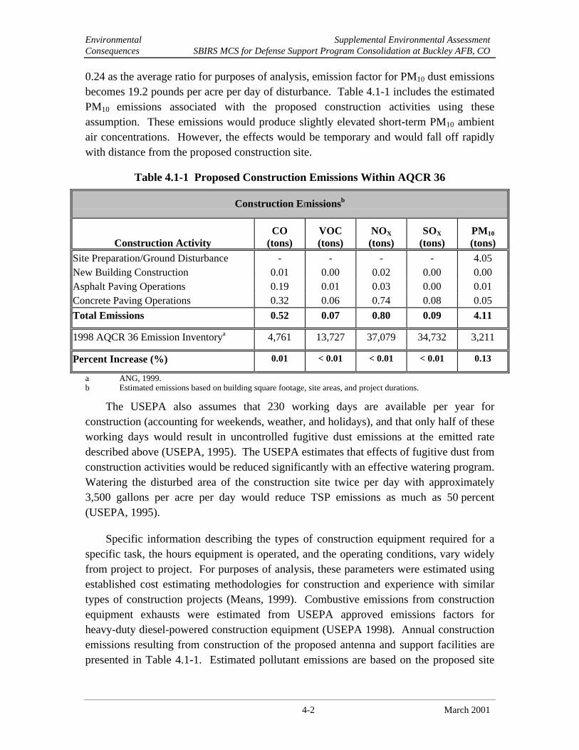
Environmental Supplemental Environmental AssessmentConsequences SBIRS MCS for Defense Support Program Consolidation at Buckley AFB, CO
4-2 March 2001
0.24 as the average ratio for purposes of analysis, emission factor for PM10 dust emissionsbecomes 19.2 pounds per acre per day of disturbance. Table 4.1-1 includes the estimatedPM10 emissions associated with the proposed construction activities using theseassumption. These emissions would produce slightly elevated short-term PM10 ambientair concentrations. However, the effects would be temporary and would fall off rapidlywith distance from the proposed construction site.
Table 4.1-1 Proposed Construction Emissions Within AQCR 36
Construction Emissionsb
Construction ActivityCO
(tons)VOC(tons)
NOX
(tons)SOX
(tons)PM10
(tons)
Site Preparation/Ground Disturbance - - - - 4.05New Building Construction 0.01 0.00 0.02 0.00 0.00Asphalt Paving Operations 0.19 0.01 0.03 0.00 0.01Concrete Paving Operations 0.32 0.06 0.74 0.08 0.05
Total Emissions 0.52 0.07 0.80 0.09 4.11
1998 AQCR 36 Emission Inventorya 4,761 13,727 37,079 34,732 3,211
Percent Increase (%) 0.01 < 0.01 < 0.01 < 0.01 0.13
a ANG, 1999.b Estimated emissions based on building square footage, site areas, and project durations.
The USEPA also assumes that 230 working days are available per year forconstruction (accounting for weekends, weather, and holidays), and that only half of theseworking days would result in uncontrolled fugitive dust emissions at the emitted ratedescribed above (USEPA, 1995). The USEPA estimates that effects of fugitive dust fromconstruction activities would be reduced significantly with an effective watering program.Watering the disturbed area of the construction site twice per day with approximately3,500 gallons per acre per day would reduce TSP emissions as much as 50 percent(USEPA, 1995).
Specific information describing the types of construction equipment required for aspecific task, the hours equipment is operated, and the operating conditions, vary widelyfrom project to project. For purposes of analysis, these parameters were estimated usingestablished cost estimating methodologies for construction and experience with similartypes of construction projects (Means, 1999). Combustive emissions from constructionequipment exhausts were estimated from USEPA approved emissions factors forheavy-duty diesel-powered construction equipment (USEPA 1998). Annual constructionemissions resulting from construction of the proposed antenna and support facilities arepresented in Table 4.1-1. Estimated pollutant emissions are based on the proposed site

Environmental Supplemental Environmental AssessmentConsequences SBIRS MCS for Defense Support Program Consolidation at Buckley AFB, CO
4-3 March 2001
areas, the duration of the project, and the specified building square footage for newconstruction.
Analysis of the data presented in Table 4.1-1 indicates that the overall ambientair quality within AQCR 36 would be slightly affected by the construction of theProposed Action. Increased emissions from construction activities would produceslightly elevated air pollutant concentrations. However, the increases would be minimal(not exceeding a 0.13 percent increase for any criteria pollutant) when compared tobaseline AQCR 36 emissions. The effects would be temporary, fall off rapidly withdistance from the proposed construction site, and would not result in any long-termimpacts. Since the estimated emissions for criteria pollutants do not exceed 10 percent ofthe air emission baseline and do not exceed de minimis levels, the Proposed Action is notconsidered regionally significant and does not violate the Colorado SIP.
Operation
Combustive emissions emergency operations are estimated from USEPA approvedemission factors (UESPA, 1995) and are based on the following assumptions:
• Generator capacity = 35,000 kW;
• Emissions control = none;
• Fuel type – diesel fuel No. 2;
• Sulfur content of fuel = 2 percent
• Operational usage = 100 hours per year; and
• Monthly operational testing = 12 hours per year.
Annual pollutant emissions resulting from operation of the proposed antennas arepresented in Table 4.1-2. Due to the small percentage increase of operational emissionassociated with the backup power generator compared to baseline conditions, theoperational phase of the Proposed Action is not anticipated to significantly impact airquality at Buckley AFB.
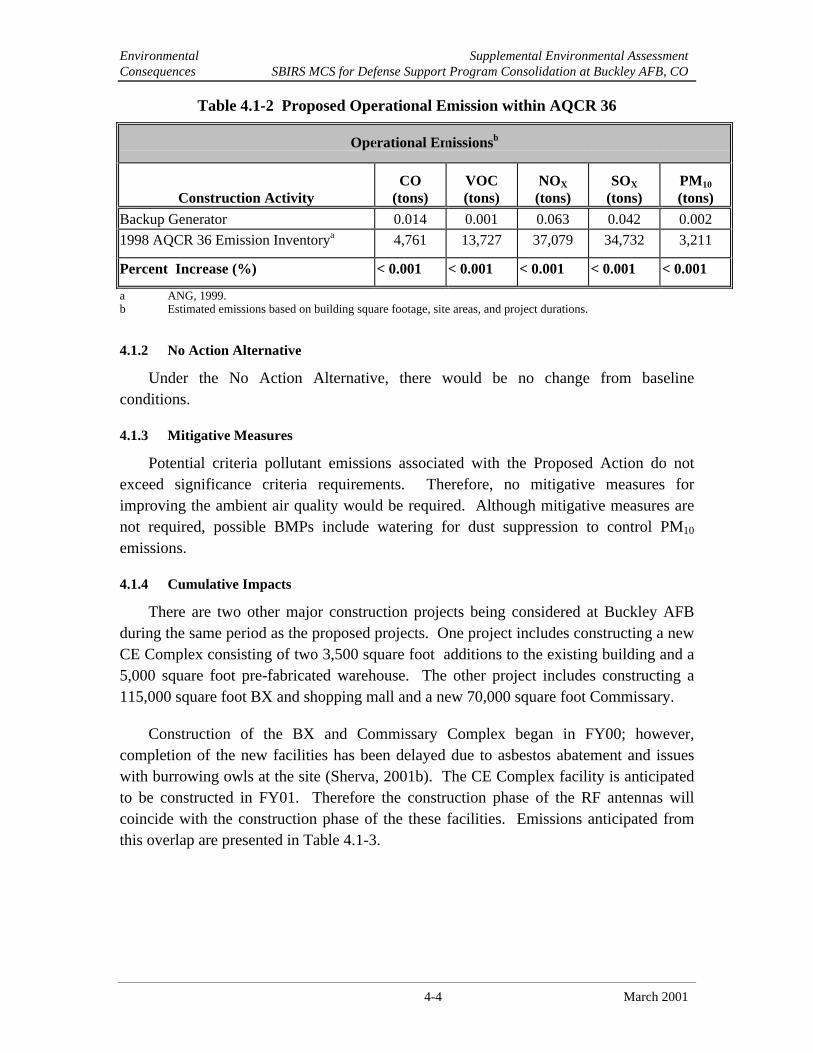
Environmental Supplemental Environmental AssessmentConsequences SBIRS MCS for Defense Support Program Consolidation at Buckley AFB, CO
4-4 March 2001
Table 4.1-2 Proposed Operational Emission within AQCR 36
Operational Emissionsb
Construction ActivityCO
(tons)VOC(tons)
NOX
(tons)SOX
(tons)PM10
(tons)
Backup Generator 0.014 0.001 0.063 0.042 0.002
1998 AQCR 36 Emission Inventorya 4,761 13,727 37,079 34,732 3,211
Percent Increase (%) < 0.001 < 0.001 < 0.001 < 0.001 < 0.001
a ANG, 1999.b Estimated emissions based on building square footage, site areas, and project durations.
4.1.2 No Action Alternative
Under the No Action Alternative, there would be no change from baselineconditions.
4.1.3 Mitigative Measures
Potential criteria pollutant emissions associated with the Proposed Action do notexceed significance criteria requirements. Therefore, no mitigative measures forimproving the ambient air quality would be required. Although mitigative measures arenot required, possible BMPs include watering for dust suppression to control PM10
emissions.
4.1.4 Cumulative Impacts
There are two other major construction projects being considered at Buckley AFBduring the same period as the proposed projects. One project includes constructing a newCE Complex consisting of two 3,500 square foot additions to the existing building and a5,000 square foot pre-fabricated warehouse. The other project includes constructing a115,000 square foot BX and shopping mall and a new 70,000 square foot Commissary.
Construction of the BX and Commissary Complex began in FY00; however,completion of the new facilities has been delayed due to asbestos abatement and issueswith burrowing owls at the site (Sherva, 2001b). The CE Complex facility is anticipatedto be constructed in FY01. Therefore the construction phase of the RF antennas willcoincide with the construction phase of the these facilities. Emissions anticipated fromthis overlap are presented in Table 4.1-3.

Environmental Supplemental Environmental AssessmentConsequences SBIRS MCS for Defense Support Program Consolidation at Buckley AFB, CO
4-5 March 2001
Table 4.1-3 Proposed Cumulative Emission within AQCR 36
Cumulative Emissionsb
Construction ActivityCO
(tons)VOC(tons)
NOX
(tons)SOX
(tons)PM10
(tons)
Emissions from Proposed Action 0.52 0.07 0.80 0.09 4.11
Emissions Associated With the BX andCommissary Complex Construction
9.4 2.9 43.2 0 46.2
Emissions Associated With the CivilEngineering Complex
0.30 0.05 0.68 0.07 1.70
Total 10.22 3.02 44.68 0.16 52.01
1998 AQCR 36 Emission Inventorya 4,761 13,727 37,079 34,732 3,211
Percent Increase (%) 0.21 0.02 0.12 < 0.01 1.62
a ANG, 1999.b Estimated emissions based on building square footage, site areas, and project durations.
While site clearing, preparation and new building construction activities wereconsidered in estimating air emissions associated with the two building additionsproposed for the CE complex, only site clearing/preparation activities were considered inestimating potential air emissions from installation of the prefabricated building.Estimated air emissions associated with the construction phase of the BX andCommissary complex were taken from the Air National Guard December 1998Environmental Assessment (ANG, 1998).
Analysis of the data presented in Table 4.1-3 indicates that the overall ambientair quality within AQCR 36 would be slightly affected by construction and operation ofthe Proposed Action. Increased emissions from construction activities would produceslightly elevated air pollutant concentrations; however, the increases do not exceed a 10percent increase over baseline conditions.
4.2 BIOLOGICAL RESOURCES
An impact to biological resources would be considered significant if the federalaction would impact a threatened or endangered species, substantially diminish habitat fora plant or animal species, substantially diminish a regionally or locally important plant oranimal species, interfere substantially with wildlife movement or reproductive behavior,and/or result in a substantial infusion of exotic plant or animal species.
4.2.1 Proposed Action
The Proposed Action would not likely have any adverse effects on biologicalresources, with the exception of the black-tailed prairie dogs present at the SBIRS site.
Environmental Supplemental Environmental AssessmentConsequences SBIRS MCS for Defense Support Program Consolidation at Buckley AFB, CO
4-6 March 2001
Biological resources at the site are markedly absent, with no native vegetation and onlysparse noxious weed cover (field bindweed) on the predominantly barren site.
Prairie dogs on the site would be removed as a result of the Proposed Action. Thiswould be a minor adverse effect because the number of prairie dogs present is low (likelyless than 10 individuals), the probability for persistence of this ward (a subgroup of thelarger colony) is low, and resources are very limited. The prairie dogs currently have tocross several hundred yards of unvegetated open space to reach the nearest suitableforage. The likelihood of predation in the open space is high, and because of the lownumber of individuals, it is probable that the ward will not persist. When considered inthe context of the black-tailed prairie dog population and the very low habitat quality onthe site, removal of these individual prairie dogs would have a negligible effect on theprairie dog population.
The Proposed Action would not have an effect on any federal or state-listed species.
4.2.2 No Action Alternative
The No Action Alternative would not result in the removal of the black-tailed prairiedogs from the site due to construction of the SBIRS antennas. However, because of thelack of resources at the site and the high probability of exposure to predators whenseeking the nearest foraging areas, the prairie dogs have a low prediction of continuedpresence at the site. Thus, the No Action Alternative would likely have a result similar tothe Proposed Action, namely, prairie dogs are not likely to persist at the SBIRS site. Nomitigation measures to compensate for this loss would take place under the No ActionAlternative.
4.2.3 Mitigative MeasuresPrior to commencing construction activities on the SBIRS site, the black-tailed
prairie dogs on the site would be live-captured and transported to a USFWS black-footedferret captive breeding facility to support the endangered species recovery program. TheUSFWS has indicated that this would be an acceptable and preferred method to deal withthe prairie dogs (Leachman, pers. comm., 2001). This action would be accomplished byusing a vacuum system to remove the animals from their burrows. The SBIRS site wouldbe monitored following collection of the prairie dogs to determine that all the prairie dogswere removed. The prairie dog burrows will be destroyed to prevent recolonization byprairie dogs or other species. The action would be taken prior to March 1, 2001 to avoidinterfering with prairie dog reproduction activities and to preclude potential effects toburrowing owls returning from migration beginning in March. Precautions would betaken to protect the prairie dogs during live-capture and transport and to ensure the healthand safety of the persons handling the animals. No mitigative measures to offset theremoval of the prairie dogs would be necessary.
Environmental Supplemental Environmental AssessmentConsequences SBIRS MCS for Defense Support Program Consolidation at Buckley AFB, CO
4-7 March 2001
4.2.4 Cumulative Impacts
The cumulative effect from construction of the SBIRS antennas would continue thetrend of development of open space in the Denver metropolitan area. Wildlife habitatsare being lost to development at a significant rate. However, change in land use at theproposed SBIRS site would not contribute to further degradation of wildlife or biologicalresources because of the lack of resources at the site. The area surrounding the SBIRSsite (except to the west) is already developed, thus the surrounding area would notexperience additional effects resulting from the Proposed Action. Future biologicalresource effects associated with the SBIRS project would likely be related to prairie dogsand the base-wide prairie dog management plan (currently in preparation) would be well-suited to deal with any potential effects. Vegetation at the site is limited to an invasivenoxious weed, and its removal would have no cumulative adverse effect; rather, the effectwould be somewhat beneficial by removing a potential source of unwanted, non-nativevegetation. Donation of black-tailed prairie dogs to the black-footed ferret captivebreeding program would have a cumulative beneficial effect in the form of support for therecovery of an endangered species.
4.3 NON-IONIZING ENERGY
Non-ionizing energy impacts would be considered significant if personnel wereexposed to levels of energy in excess of the PELs established under IEEE standards formaximum permissible exposure for uncontrolled environments (1.2 mW/cm2 for S-band[1.8 GHz] and 30 mW/ cm2 for Q-band [45 GHz], or if the power density levelsestablished for safe operating distance for fuels would be exceeded in the affected area(5,000 mW/cm2). Uncontrolled environments are locations where there is the exposure ofindividuals who have no knowledge or control of their exposure. The exposures mayoccur in living quarters or workplaces where there are no expectations that the exposurelevels may exceed the levels described above (IEEE, 1992).
RF hazards to electro-explosive devices (EEDS) and fuels may result from excessiveRF energy. EEDs are small pyrotechnic or explosive devices (primers, detonators,blasting caps, squibs) that are ignited electrically by the passage of an electric current todetonate an explosive charge. Many of these devices are initiated by low levels ofelectrical energy and are susceptible to unintentional ignition by many forms of direct orinduced stray electrical energy such as RF energy. RF energy may ignite fuel by inducingcurrent in metallic objects, which could cause sparks in the presence of fuel vapors. Thelocation of fuel and ordnance with respect to an RF antenna facility should be givenextensive study prior to siting the RF device to ensure proper safe operating distances orseparation between the antennas and the fuel or EEDS. The safe operating distance forfuels is based on a power density level equal to or less than 5 W/cm2 (5,000 mW/cm2) in

Environmental Supplemental Environmental AssessmentConsequences SBIRS MCS for Defense Support Program Consolidation at Buckley AFB, CO
4-8 March 2001
the affected area. The safe power density level of ordnance is dependent on frequency,exposure, and sensitivity of the particular device.
4.3.1 Proposed Action
As discussed in paragraph 3.3.1, RF electromagnetic energy is generated by satellitecommunications equipment located within the 2 SWS facility at Buckley AFB. Thissection describes the RF equipment and potential impacts associated with the two newSBIRS communications antennas, SB1 and SB2, proposed to be constructed at thelocations shown in Figure 2-2. Figure 2-3 shows a plan view of the SBIRS antenna diskand radome. The existing DSP antennas would be used for communication with satelliteson an interim basis and ultimately would be replaced by the SBIRS satellitecommunication system using the SB1 and SB2 antennas associated with the SBIRS MCS.Although the exact locations and specific operational parameters of the three futureSBIRS LEO antennas (LEO1, LEO2, and LEO3) to be constructed near the MCS are notfinal, their cumulative RF energy effects will be discussed and compared with the SBIRSantennas and the DSP antennas (DB1, DB2, and DB3) in paragraph 4.3.4. Detailedinformation on the RF energy equipment and potential impacts associated with the SBIRScommunications antennas and their comparisons to the three DSP antennas and the threeLEO antennas are presented in Appendix B. This information was provided by theSystems Engineering Directorate of the Aerospace Corporation (Aerospace Corp, 2001).
4.3.1.1 Health and Safety
Operating parameters of the SBIRS antennas are presented in Table 4.3-1 and operatein the 3 kHz to 300 GHz frequency range and, thus the associated PELs would be1.2 mW/cm2 for S-band frequencies of 1.8 GHz and 30 mW/cm2 for Q-band frequenciesof 45 GHZ for uncontrolled environments. For short duration exposures, the lowerthreshold, below which personnel are considered safe from non-ionizing energy, is 10mW/ cm2. However, the “worse case” lower limit for continuous (24-hour/day, 7days/week) exposure to all areas of the body or to any type of electrically activatedexplosive devices is 1 mW/cm2.
According to the SBIRS System Safety Hazard Analysis Report, which documentsthe RF power density calculations, the RF power density analysis shows that RFtransmissions from the SBIRS antennas do not exceed the maximum contractualrequirement for RF exposure (Lockheed Martin, 2001). There would be no hazardouslevels of RF power radiating from the antennas reflectors as determined by the analysis.The maximum power density calculated at horizon (ground level) for uniformillumination was 3.19 mW/cm2 within a radius of 168 meters (551 feet.) from the antennawith the S-Band transmitter operating at rated power (Lockheed Martin, 2001). Thispower density level is lower than the maximum limit of 5mW/cm2 for the S-Band and Q-Band operational frequencies.

Environmental Supplemental Environmental AssessmentConsequences SBIRS MCS for Defense Support Program Consolidation at Buckley AFB, CO
4-9 March 2001
Table 4.3-1 SBIRS Antenna Operational Parameters
AntennaDesignation
AntennaDiameter
(feet)
TransmitFrequency
(GHz)
TransmitPower(Watts)
Maximum OperationalTime (days/wk,
hours/day)
MinimumOperational
ElevationAngle (degrees)
SB1 33 1.8 2000 7 days/wk, 24 hrs/day 5SB1 33 45 20 7 days/wk, 24 hrs/day 5SB2 33 1.8 2000 7 days/wk, 24 hrs/day 5SB2 33 45 20 7 days/wk, 24 hrs/day 5
Source: Aerospace Corp., 2001
The DoD JSC issued a memorandum to SMC in November 2000 concerning itsradiation hazard assessment of the proposed SBIRS antennas. The objective of theassessment was to determine the maximum electromagnetic energy levels and associatedenergy hazard potential at the proposed location of the SBIRS MCS antennas. The RFenergy levels were measured using a spectrum analyzer and a broadband horn antennacoupled with a laptop computer. The broadband horn antenna was mounted to a tripodanchored to a man-lift bucket and raised to a height of 54-feet. This height correspondsto the expected elevation of the SBIRS radome, the point at which the highest RF levelswould be expected. Results of the RF energy measurements indicated that maximumpower density of the proposed SBIRS antennas under all test conditions was 16 µW/cm2.According to the JSC, this measurement is less than the most conservative maximumpermissible exposure limit by a factor of 400 (see Appendix C for the specific detailscontained in the memorandum).
Results of the RF S-Band and Q-Band power density levels calculated for the SBIRSand DSP antenna study conducted by the Aerospace Corporation are presented inAppendix B and shown in Table 4.3-2. Figure 4 in Appendix B shows the AerospaceCorporation RADHAZ simulation geometry for examining the antennas. Figures 5through 8 in Appendix B indicate the power density levels along three geometrical pathsfor SB1, SB2, D1, and D2 for both the S and Q-bands. The first path is along the antennaaxis centerline, the second is extending away from the antenna rim, and the third is sixfeet above the ground in the direction the antenna is pointing. The latter configurationassumes a “worst case two-dimensional pointing angle” condition. This condition isdefined as the case where the antenna is pointed at it lowest elevation angle of 5º abovethe horizon. This is the “worst case” in the sense that it delivers the most power to theground as possible. In actual operation, the antenna would deliver less power to theground than this “worse case” because it will be pointed at an angle higher than 5°. Table4.3-2 presents the maximum power density levels for SB1, SB2, D1, and D2. Thesepower levels are graphically shown in Figures 5 and 6 in Appendix B.

Environmental Supplemental Environmental AssessmentConsequences SBIRS MCS for Defense Support Program Consolidation at Buckley AFB, CO
4-10 March 2001
Table 4.3-2 Maximum Power Density Levels for SBIRS and DSP Antennas
Maximum Power Density Levels (mW/cm2)
Antenna Antenna Axis(Black)
Away from Antenna Axis(Red)
6-feet Above Ground(Green)
S-Band Q-Band S-Band Q-Band S-Band Q-Band
SB1, SB2 3.19 0.1 0.25 0.0012 0.012 0.000015
D1, D2 10 - 0.14 - 0.011 -
In comparing Figures 5 and 6 and the power density levels presented in Table4.3-2, several conclusions can be reached. First, the curves plotted in green on bothfigures refer to S-Band energy power density levels predicted six feet above theground around each antenna at distances given in feet from the antenna. Note that the"green plot" power density levels (ground values) are very similar for SB1/SB2(Figure 5) and D1/D2 (Figure 6) as the energy emanates away from the vertex of theantenna. Also note that these levels are more than 100 times below the "worst case"allowable RADHAZ exposure levels of 1 mW/cm2 at all ground locations around theMCS.
Second, the red plots in Figures 5 and 6 and the power density levels presented inTable 4.3-2 show power levels at the beam edge or along the rim of a vectorextending out from the rim of the antenna as shown in Figure 4 of Appendix B.These power levels are also below 1 mW/cm2 and are power levels that will bereached only at significant heights above the ground. Also note that as the distanceaway from the antenna vertex increases, the height also increases, as showngeometrically in Figure 4.
Third, the black plots in Figures 5 and 6 and the power density levels presentedin Table 4.3-2 show the maximum power levels reached in the center portion of thebeam. For the Proposed Action, all S-Band power levels are below 10 mW/cm2 at alldistances from the vertex of the antenna. This is not currently true for D1 and D2which go up to approximately 10 mW/cm2 in the center of the beam at distances lessthan 100 feet. This does not imply that any unacceptable hazards exist from D1 orD2, but demonstrates that antennas SB1 and SB2 generate a safer energy power levelalong the beam axis, one that is lower than the D1 and D2.
Figure 7 in Appendix B shows the power density levels of the SBIRS antennas usingQ-band transmitting power presented in Table 4.3-1. The information presented in Figure7 are shown in Table 4.3-2. The results show that in all parts of the transmitting beam,SB1 and SB2 are below 1 mW/ cm2 and do not represent a RF energy hazard.
Environmental Supplemental Environmental AssessmentConsequences SBIRS MCS for Defense Support Program Consolidation at Buckley AFB, CO
4-11 March 2001
According to results of the SBIRS System Safety Hazard Analysis Report preparedby Lockheed Martin, the energy hazard assessment preformed by the JCS, and the studyconducted by the Aerospace Corporation, the RF energy emitted from the SBIRSantennas is below the IEEE standards for maximum permissible exposure foruncontrolled environments at all ground and air levels.
Additionally, the safe operating distance for fuels is based on a power density levelequal to or less than 5000 mW/cm2 in the affected area. As shown in Table 4.3-2, thepower density levels emitted from the SBIRS antennas are much less than the levelestablished for the safe operating distance for fuels, no potential fuel ignition hazardexists.
4.3.1.2 Airspace
Aircraft operating at Buckley AFB either take off or land in a northwest-southeastdirection, which is east and north from the proposed location of the SBIRS antennas.Aircraft are required to turn left after reaching their departure altitude. After reaching therequired altitude the aircraft are restricted from flying directly over or in the generalvicinity of the radomes located at 2 SWS or the ADF facilities (Ortega, 2001).Commercial airlines would also be restricted from flying over or near the base whileeither approaching or departing the Denver International Airport.
Personnel flying inside aircraft could potentially be exposed for a brief moment toRF energy while crossing the beam path of the antenna. However, as discussed above,RF energy emitted from the SBIRS antennas is low enough to not have an effect onhuman health. Instrumentation in aircraft are typically shielded from such energy fieldsand therefore, would not be damaged from the RF energy emitted from the SBIRSantennas.
4.3.2 No Action Alternative
The RF energy emitted as a result of the No Action Alternative, e.g., continued use ofthe existing DSP antennas, is expected to be similar to the Proposed Action. The RFenergy assessment conducted by the Aerospace Corporation on the DSP antennas ispresented in Appendix B.
4.3.3 Mitigative Measures
No mitigative measures would be required. However, the following safetyprecautions and BMPs should be followed: 1) locate RF energy warning signs on the rearof each reflector petal; 2) establish and mark restrictive areas to prevent personnel fromentering any RF energy hazard area; 3) ensure authorized personnel disable antennatransmissions prior to performing maintenance; and 4) ensure that antenna lockout andstop procedures are in place and included in maintenance technical orders.

Environmental Supplemental Environmental AssessmentConsequences SBIRS MCS for Defense Support Program Consolidation at Buckley AFB, CO
4-12 March 2001
4.3.4 Cumulative Impacts
Three SBIRS LEO antennas will be constructed on 10 foot by 10 foot concretefoundations located in the general vicinity of the SBIRS antennas. Figure 4-1 shows theapproximate locations of the three LEO antennas in relation to the two SBIR HEO/GEOantennas. Figure 4-2 shows the approximate locations of the LEO and DSP antennas inrelation to the two SBIRS HEO/GEO antennas. For their antenna study, the AerospaceCorporation assumed the LEO antennas would have operational parameters as thoseshown in Table 1 in Appendix B (Aerospace Corp., 2001). The power density levels ofthe future SBIRS LEO antennas using Q-band transmitting power are shown in Figure 8in Appendix B. Figure 8 shows that in the main beam portion of LEO1, LEO2, andLEO3 there are small excursions above 1 mW/cm2 out to a distance of 50 feet. Theseareas must be controlled access for future LEO operations to minimize potential RFenergy hazards (Aerospace Corp., 2001).
Two aspects to consider in assessing the cumulative RF energy impact with theoperation of antennas SB1, SB2, LEO1, LEO2, and LEO3 are the nature of the energybeing emitted and the operational use of the antennas. All SBIRS antennas would emitnon-ionizing energy, which is not considered cumulative from a energy-biology andoncological perspective. RF fields are too low in power to produce ionized chemicalatoms and cellular damage that results from ionizing energy. If the RF power levels arehigh, however, heating can occur, and if cellular structure cannot remove the heat overtime, then biological damage can occur. This cannot occur if RF fields are below 1mW/cm2 and generally does not occur at levels below 5 mW/cm2 (Aerospace Corp.,2001).
The second aspect to consider is the duty cycle for the “transmit mode” of the SBIRSantennas. The Aerospace Corporation studied the cumulative environmental impactperspective for antennas SB1, SB2, LEO1, LEO2, LEO3, DB1, DB2, and DB3 (receiveonly). The locations of all three sets of antennas are shown in Figure 4-2. The duty cycleconsists of two elements: time or duration the transmission is occurring, and theoperational elevation angle (angular pointing) aspect of the antennas. Regarding theduration of transmission, the worst-case assumption of “continuous transmission” hasbeen assumed as presented in Table 1 of Appendix B. In the case of angular pointing,unlike radar antenna which continuously transmit in many directions, the SBIRS

Antenna Siting of SB1, SB2,
Buckley AFB, Colorado
and Three Future Leo Antennas
Figure 4-1

Environmental Supplemental Environmental AssessmentConsequences SBIRS MCS for Defense Support Program Consolidation at Buckley AFB, CO
4-14 March 2001
THIS PAGE INTENTIONALLY LEFT BLANK

Buckley AFB, Colorado
SBIRS, LEO, and DSP Antennas
Figure 4-2
Location of

Environmental Supplemental Environmental AssessmentConsequences SBIRS MCS for Defense Support Program Consolidation at Buckley AFB, CO
4-16 March 2001
THIS PAGE INTENTIONALLY LEFT BLANK

Environmental Supplemental Environmental AssessmentConsequences SBIRS MCS for Defense Support Program Consolidation at Buckley AFB, CO
4-17 March 2001
“command and control” antennas would be fixed at a few locations and used to transmitsignals in the direction of one particular satellite at a time. In other words, there wouldnever be a time when more than one antenna was pointed at the same location in space.Therefore, the arithmetic addition of the energy fields is not a consideration in assessingcumulative RF energy hazard (Aerospace Corp., 2001).
As a result of all the studies and energy hazard assessments presented in thissupplemental EA, no unacceptable hazard from the cumulative effect of RF energy isexpected from the construction and operation of SB1 and SB2, or the future LEOantennas. At all ground and air locations surrounding SB1, SB2, D1, D2, and D3, thepower density levels are expected to be within acceptable levels (Aerospace Corp., 2001).
4.4 UTILITIES
Impacts to the electrical and natural gas utility systems would be consideredsignificant if the degree to which an increase in the demands on the utility distributionsystems would result in the need for additional capacity or new support and/or supplyfacilities.
4.4.1 Electricity
4.4.1.1 Proposed Action
Under the proposed action, 150 feet of concrete encased underground electricalutility lines would extend from a utility pad located northwest of the MCS building toeach antenna. Figure 2-2, Site Layout for Antennas SB1 and SB2, displays the proposedroute for the utility extension.
Electrical usage would be necessary to supply power to each of the antennas as wellas auxiliary support equipment and facility infrastructure. It is estimated that in order tosupport this auxiliary equipment, 60 kVA and 30 kVA would be required for SB1 andSB2 respectively. Assuming 24-hour energy usage of auxiliary equipment and a powerfactor of 0.8, 51,840 kWh per month would be used under the proposed action. Thisequates to approximately 15 percent of the current SBIRS electricity usage rate and lessthan 1 percent of current base usage rates.
Under the Proposed Action, electricity would be required to power antennamovement and RF transmission. It is estimated that 30 kVA each would be required bySB1 and SB2. Assuming a power factor of 0.8, electrical power required by bothantennas would equate to a consumption rate of 3,456 kWh per month. This energyconsumption rate is equivalent to 1 percent of the current electricity demand of SBIRSand less than 1 percent of the current base usage rates. Therefore, the Proposed Action isnot anticipated to negatively impact the base electrical distribution system.

Environmental Supplemental Environmental AssessmentConsequences SBIRS MCS for Defense Support Program Consolidation at Buckley AFB, CO
4-18 March 2001
4.4.1.2 No Action Alternative
Under the No Action Alternative, there would be no effect on the electricity usageand the demand for energy would remain at the same levels experienced under baselineconditions for Buckley AFB.
4.4.1.3 Mitigative Measures
No mitigative measures to improve energy management practices at Buckley AFBwould be required.
4.4.1.4 Cumulative Impacts
There are two other major construction projects being considered at Buckley AFBduring the same period as the proposed projects. One project includes constructing a newCE Complex consisting of two 3,500 square foot (additions to the existing building) anda 5,000 square foot pre-fabricated warehouse. The other project includes constructing a115,000 square foot BX and shopping mall and a new 70,000 square. Commissary.
As there is no significant electrical usage during construction of either the CEComplex or the BX and Commissary Complex, only operational energy usage areanalyzed for cumulative impacts.
Based on 24-hour operation of the BX and Commissary Complex, an estimatedelectrical usage of 0.03 kWh per day per square foot would be required, resulting in 5,400kWh per day or 162,000 kWh per month (ANG, 1998). Using this same electricity usagerate, the total electricity required for the 9,000 square foot CE Complex would be 262.7kWh per day or 7881 kWh per month. Combining this with the 51,840 kWh per monthestimated to support the Proposed Action, base usage would increase by 221,721 kWh permonth. This increase represents an approximate 3 percent over current basewideelectricity usage. Therefore, the cumulative impact from implementation of the ProposedAction is not anticipated to negatively impact the electrical infrastructure at BuckleyAFB.
4.4.2 Natural Gas
4.4.2.1 Proposed Action
Under the Proposed Action, natural gas would be utilized for heating the work areasfor each of the antennas. It is estimated that during the winter months 1.1 MBtu/hourwould be necessary for each antenna, thus increasing natural gas usage by 2.2 MBtu/hour.Assuming the highest natural gas usage would occur primarily between November andMarch of each CY, this usage would represent approximately 2 percent of the currentSBIRS natural gas usage rate, and less than 1 percent of the average annual base usage

Environmental Supplemental Environmental AssessmentConsequences SBIRS MCS for Defense Support Program Consolidation at Buckley AFB, CO
4-19 March 2001
rate. Therefore, the Proposed Action is not anticipated to negatively impact the basenatural gas distribution system.
4.4.2.2 No Action Alternative
Under the No Action Alternative, there would be no effect on the natural gas usageand the demand for energy would remain at the same levels experienced under baselineconditions for Buckley AFB.
4.4.2.3 Mitigative Measures
No mitigative measures to improve energy management practices at Buckley AFBwould be required.
4.4.2.4 Cumulative Impacts
There are two other major construction projects being considered at Buckley AFBduring the same period as the proposed projects. One project includes constructing a newCE Complex consisting of two 3,500 square foot additions to an existing building and a5,000 square foot pre-fabricated warehouse. The other project includes constructing a115,000 square foot BX and shopping mall and a new 70,000 square foot Commissary.As there is no significant electrical usage during construction of either the CE Complexor the BX and Commissary Complex, only the operational energy usage are analyzed forcumulative impacts.
Based on 24-hour operation of the BX and Commissary Complex, an estimatednatural gas consumption of 99.05 Btu per square foot per day would be required, resultingin 18.3 MBtu per day, or 0.76 MBtu per hour (ANG, 1998). Using this same electricityusage rate, the total electricity required for the 9,000 square foot CE Complex buildingswould be 0.891 MM Btu per day, or 37,143.24 kWh per hour. Combining this with the2.2 MBtu per hour estimated to support the Proposed Action, base usage would increaseby 3 MBtu/hour. This increase represents an approximate 0.01 percent over currentbasewide electricity usage. Therefore, the cumulative impact from implementation of theProposed Action is not anticipated to negatively impact the electrical infrastructure atBuckley AFB.
4.5 UNAVOIDABLE ADVERSE ENVIRONMENTAL IMPACTS
Unavoidable impacts would result from the implementation of the Proposed Action.However none of the impacts would be significant. The emission of air pollutantsassociated with construction activities would be an unavoidable condition, but is notconsidered significant. The loss of aggregate used for concrete, which would becomeinaccessible, would occur as a result of construction activities. However, the impactwould be insignificant due to the small amount needed. Site grading during construction
Environmental Supplemental Environmental AssessmentConsequences SBIRS MCS for Defense Support Program Consolidation at Buckley AFB, CO
4-20 March 2001
would remove minimal vegetation. The use of nonrenewable energy resources isunavoidable, but the amount used would be insignificant.
4.6 IRREVERSIBLE AND IRRETRIEVABLE COMMITMENT OFRESOURCES
NEPA requires that environmental analysis include identification of “...anyirreversible and irretrievable commitments of resources which would be involved in theProposed Action should it be implemented.” Irreversible and irretrievable resourcecommitments are related to the use of nonrenewable resources and the effects the use ofthese resources would have on consumption or destruction of a resource that could not bereplaced in a reasonable period of time.
The irreversible environmental changes that could result from implementation of theProposed Action include consumption of material resources, energy resources, and humanresources.
Material resources used for the Proposed Action include building materials forconstruction, conduits for utilities, concrete for the antenna foundations, slabs, andsidewalks around the perimeter of the antennas. The materials that would be consumedare not in short supply and are readily available from suppliers in the region. Use of thesematerials would not limit other unrelated construction activities and, therefore, would notbe considered significant.
Energy resources would be irretrievably lost. These include petroleum-basedproducts such as gasoline and diesel fuel, natural gas, and electricity. During facilityconstruction, gasoline and diesel fuel would be used for operation of equipment and othervehicles. Natural gas and electricity would be used in the units after they are completed.However, because these units would be more energy efficient than those being replaced,consumption of these resources would be expected to decrease. Consumption of theseenergy resources would not place a significant demand on their availability in the region.Therefore, no adverse impacts would be expected.
The use of human resources for facility construction is considered an irretrievableloss, only in that it would preclude such personnel from engaging in other work activities.However, the use of human resources for the Proposed Action represents employmentopportunities and is considered beneficial.
4.7 RELATIONSHIP BETWEEN SHORT-TERM USES OF THEENVIRONMENT AND LONG-TERM PRODUCTIVITY
The site for the SBIRS antennas has been occupied by black-tailed prairie dogs.There are no short-term uses of the site. The Proposed Action and the No Action

Environmental Supplemental Environmental AssessmentConsequences SBIRS MCS for Defense Support Program Consolidation at Buckley AFB, CO
4-21 March 2001
Alternative would not affect long-term productivity of the environment since nosignificant environmental impacts are anticipated and natural resources would not beaffected.

Environmental Supplemental Environmental AssessmentConsequences SBIRS MCS for Defense Support Program Consolidation at Buckley AFB, CO
4-22 March 2001
THIS PAGE INTENTIONALLY LEFT BLANK

Regulatory Review and Supplemental Environmental AssessmentPermit Requirements SBIRS MCS for Defense Support Program Consolidation at Buckley AFB, CO
5-1 March 2001
SECTION 5REGULATORY REVIEW AND PERMIT REQUIREMENTS
This section discusses regulatory requirements that would be applicable to theProposed Action and No Action Alternative. A permit would be required to trap andrelocate black-tailed prairie dogs prior to construction of the Proposed Action.
5.1 AIR QUALITY
Colorado Regulation No. 3, Section B (ii) requires any owner or operator conductingclearing or leveling activities of land greater than 1 acre in nonattainment areas for PM10
to use all available and practical methods that are “technologically feasible andeconomically reasonable” to minimize particulate emissions. Except as specificallyauthorized under Regulation No. 3, sources are exempt from general construction permitsbecause by themselves, or cumulatively as a category, are deemed to have a negligibleimpact on air quality. Sources exempt from Air Pollution Emission Notice (APEN) arelisted in Section II, Part A of Regulation No. 3. Disturbance of surface areas that do notexceed 25 contiguous acres and do not exceed 6 months in duration are exempt fromAPEN permit requirements (USAF, 2000).
Air quality issues at Buckley AFB were evaluated with respect to the followingregulations and permits identified in Table 5.1.
Table 5.1 Regulations and Permits Associated with Air Quality
Regulation or Permit Responsible Agency Relevance to Proposed Action
Title V PermitColorado Department ofPublic Health &Environment (CDPHE), AirPollution Control Division
Possibly Relevant. A stationary source such
as a backup generator may require
modifications to the current Buckley AFB
Title V permit, if not considered an exempt
source. Dependent upon CDPHE
discretion.
Conformity Analysis United Stated EnvironmentalProtection Agency
Not Relevant. Results in total emission do
not equal or exceed 10 percent of the air
quality control area’s emission inventory for
any criteria pollutant.
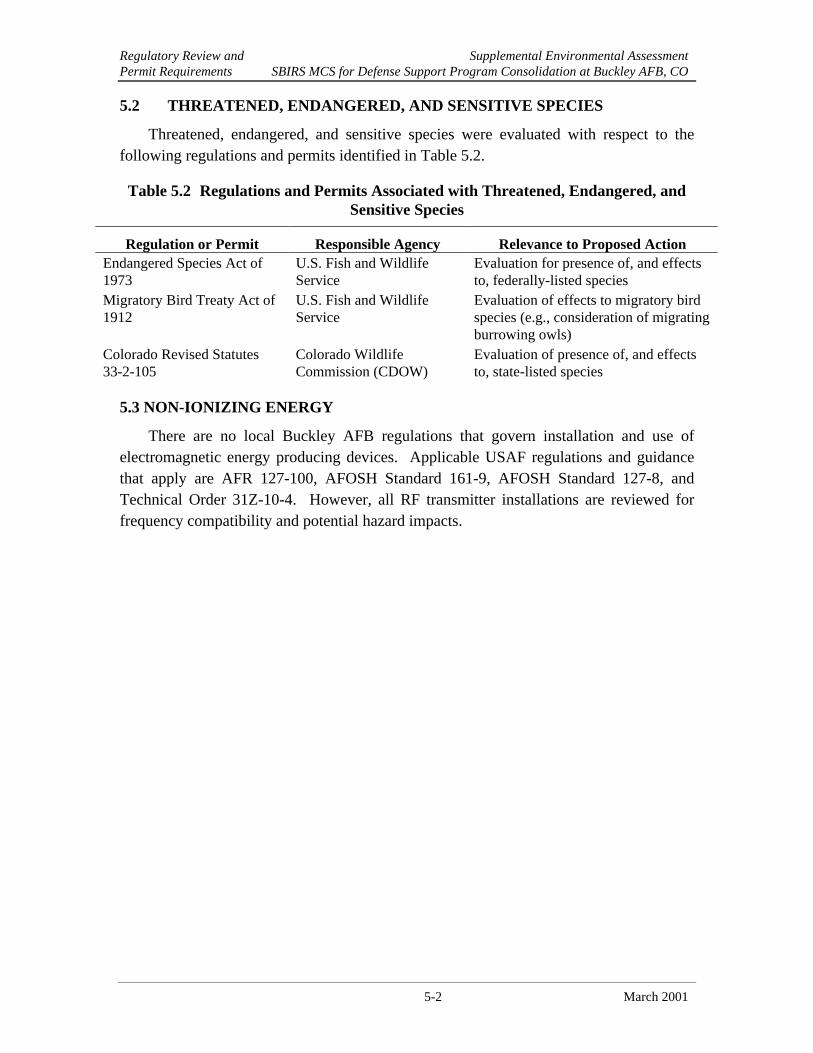
Regulatory Review and Supplemental Environmental AssessmentPermit Requirements SBIRS MCS for Defense Support Program Consolidation at Buckley AFB, CO
5-2 March 2001
5.2 THREATENED, ENDANGERED, AND SENSITIVE SPECIES
Threatened, endangered, and sensitive species were evaluated with respect to thefollowing regulations and permits identified in Table 5.2.
Table 5.2 Regulations and Permits Associated with Threatened, Endangered, andSensitive Species
Regulation or Permit Responsible Agency Relevance to Proposed ActionEndangered Species Act of1973
U.S. Fish and WildlifeService
Evaluation for presence of, and effectsto, federally-listed species
Migratory Bird Treaty Act of1912
U.S. Fish and WildlifeService
Evaluation of effects to migratory birdspecies (e.g., consideration of migratingburrowing owls)
Colorado Revised Statutes33-2-105
Colorado WildlifeCommission (CDOW)
Evaluation of presence of, and effectsto, state-listed species
5.3 NON-IONIZING ENERGY
There are no local Buckley AFB regulations that govern installation and use ofelectromagnetic energy producing devices. Applicable USAF regulations and guidancethat apply are AFR 127-100, AFOSH Standard 161-9, AFOSH Standard 127-8, andTechnical Order 31Z-10-4. However, all RF transmitter installations are reviewed forfrequency compatibility and potential hazard impacts.

Supplemental Environmental AssessmentList of Preparers SBIRS MCS for Defense Support Program Consolidation at Buckley AFB, CO
6-1 March 2001
SECTION 6LIST OF PREPARERS
Name DegreeProfessional
DisciplineYears of
ExperienceAnthony Davis, P.E.Parsons EngineeringScience
B.S., Civil Engineering Project Manager,DOPAARF Energy
24
Don KellettParsons EngineeringScience
B.S., Wildlife Biology BiologicalResources
9
Rachey PetenParsons EngineeringScience
B.S., Environmental Engineering Air Quality,Utilities
4
R.C. Wooten, Ph.D.Parsons EngineeringScience
Ph.D., Ecology/Biology Technical Review 31

Supplemental Environmental AssessmentList of Preparers SBIRS MCS for Defense Support Program Consolidation at Buckley AFB, CO
6-2 March 2001
THIS PAGE INTENTIONALLY LEFT BLANK
List of Persons Supplemental Environmental AssessmentAnd Agencies Consulted SBIRS MCS for Defense Support Program Consolidation at Buckley AFB, CO
7-1 March 2001
SECTION 7LIST OF PERSONS AND AGENCIES CONSULTED
This section lists the individuals consulted during preparation of this supplementalEA.
7.1 FEDERAL AGENCIES
Buckley AFB, Colorado
Maj Steven Miller, SMC/MTSGMr. Gerald O’Brian, 821 SPTS/CEVMs. Elise Sherva, UNITEC
Los Angeles AFB, California
Mr. Theodore Krawczyk, SMC/AXFVMr. Daniel Park, SMC/AXFC
Peterson AFB, Colorado
Ms. Beth Gibeau, HQ AFSPC/CEVPMr. William Hume, 21 SW/JAMr. Stan Rogers, HQ AFSPC/CEVP
U.S. Fish and Wildlife Service Ecological Services Field Office
Robert Leachman, Senior Staff BiologistU.S. Fish and Wildlife ServiceGrand Junction, CO
7.2 STATE AGENCIESRoger Crawford, Law Enforcement BranchColorado Division of WildlifeDenver, CO
7.3 OTHERSStewart Breck, Wildlife EcologistColorado State UniversityFort Collins, CO

List of Persons Supplemental Environmental AssessmentAnd Agencies Consulted SBIRS MCS for Defense Support Program Consolidation at Buckley AFB, CO
7-2 March 2001
Jan-W. Briede, Senior Project ManagerGeo-Marine, Inc.Newport News, VA
Mr. Charles Griffice, Ph.DThe Aerospace CorporationEl Segundo, CA
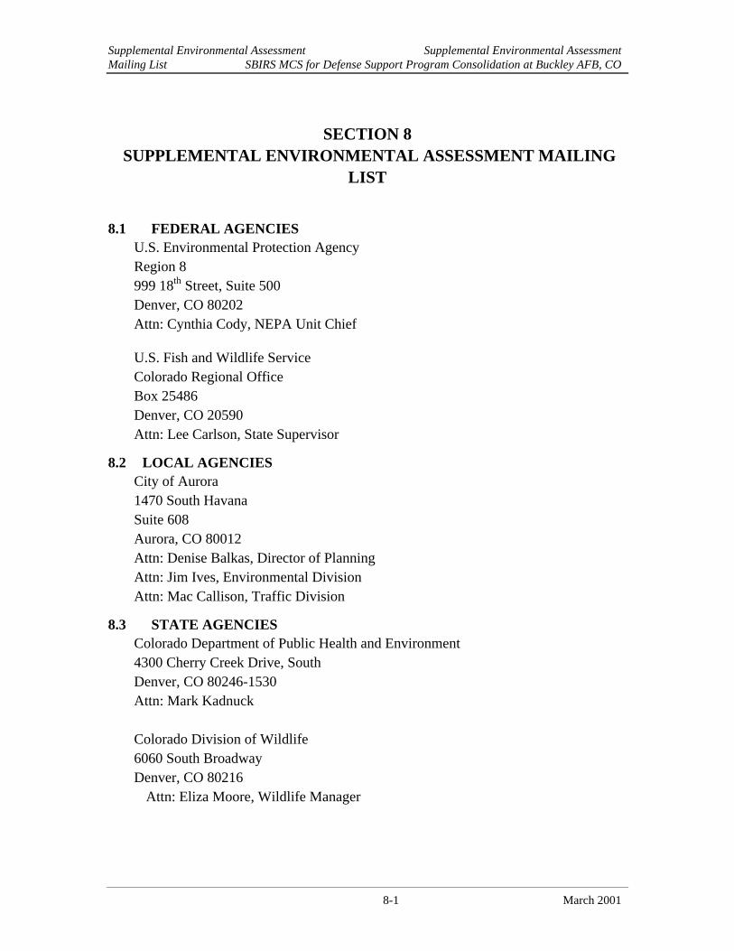
Supplemental Environmental Assessment Supplemental Environmental AssessmentMailing List SBIRS MCS for Defense Support Program Consolidation at Buckley AFB, CO
8-1 March 2001
SECTION 8 SUPPLEMENTAL ENVIRONMENTAL ASSESSMENT MAILING
LIST
8.1 FEDERAL AGENCIESU.S. Environmental Protection AgencyRegion 8999 18th Street, Suite 500Denver, CO 80202Attn: Cynthia Cody, NEPA Unit Chief
U.S. Fish and Wildlife ServiceColorado Regional OfficeBox 25486Denver, CO 20590Attn: Lee Carlson, State Supervisor
8.2 LOCAL AGENCIESCity of Aurora1470 South HavanaSuite 608Aurora, CO 80012Attn: Denise Balkas, Director of PlanningAttn: Jim Ives, Environmental DivisionAttn: Mac Callison, Traffic Division
8.3 STATE AGENCIESColorado Department of Public Health and Environment4300 Cherry Creek Drive, SouthDenver, CO 80246-1530Attn: Mark Kadnuck
Colorado Division of Wildlife6060 South BroadwayDenver, CO 80216
Attn: Eliza Moore, Wildlife Manager

Supplemental Environmental Assessment Supplemental Environmental AssessmentMailing List SBIRS MCS for Defense Support Program Consolidation at Buckley AFB, CO
8-2 March 2001
THIS PAGE INTENTIONALLY LEFT BLANK

Supplemental Environmental AssessmentReferences SBIRS MCS for Defense Support Program Consolidation at Buckley AFB, CO
9-1 March 2001
SECTION 9REFERENCES
Aerospace Corp., 2001. SBIRS Antenna Study Results, prepared by Charles P. Griffice,Ph.D., Senior Project Engineer, Systems Engineering Directorate, The AerospaceCorporation, El Segundo, California, January 26, 2001.
ANG, 1995. Air National Guard, Programmatic Environmental Assessment, SecondSpace Warning Squadron, Air Force Space Command, Buckley Air NationalGuard Base, Colorado, March, 1995.
ANG, 1996. Air National Guard, Environmental Assessment of Proposed Construction atBuckley Air National Guard Base, Colorado Air National Guard, Aurora, CO,December.
ANG, 1999. Air National Guard, Environmental Assessment for the Construction of aBase Exchange and Commissary Complex, Buckley Air National Guard Base,Colorado, January.
ANG, 2000. Proposed Prairie Dog Management Practices at Buckley Air NationalGuard Base. Colorado Air National Guard, Aurora, Colorado, April.
CDOW, 2001. Colorado Division of Wildlife State Endangered, Threatened and WildlifeSpecies of Special Concern from DOW website (5 Jan):http://www.dnr.state.co.us/wildlife/T&E/list.asp
CNHP, 2001. Colorado Natural Heritage Program. State plant species information fromsource (5 Jan): http://ndis.nrel.colostate.edu/ndis/rareplants/masterlist.html
CNHP, 2000. Colorado Natural Heritage Program, Colorado State University, NaturalHeritage Inventory of Buckley Air National Guard Base, Arapahoe County,Colorado. July.
IEEE, 1992. Institute of Electrical and Electronics Engineers (IEEE) Standard C95.1-1991, IEEE Standard for Safety Levels with Respect to Human Exposure to RadioFrequency Electromagnetic Fields, 3 kHz to 300 GHz., April 1992.
Leachman, Robert. 2001. Personal communication between Robert Leachman, SeniorStaff Biologist, U.S. Fish and Wildlife Service, Ecological Services Field Office,Grand Junction, Colorado and Don Kellett, Wildlife Biologist, ParsonsEngineering Science, Inc., Denver, Colorado, January 11, 2001.
Lockheed Martin, 2001. Information provided by Lockheed Martin Mission and DataSystems – Western Region, January 8, 2001.
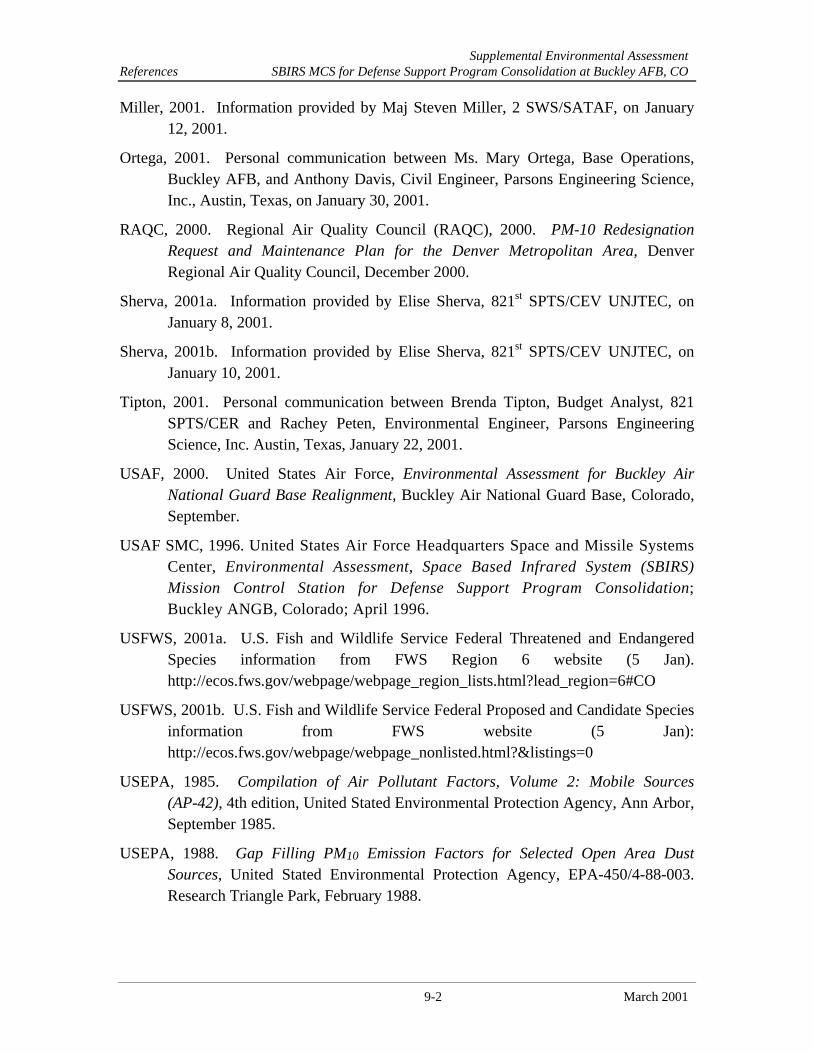
Supplemental Environmental AssessmentReferences SBIRS MCS for Defense Support Program Consolidation at Buckley AFB, CO
9-2 March 2001
Miller, 2001. Information provided by Maj Steven Miller, 2 SWS/SATAF, on January12, 2001.
Ortega, 2001. Personal communication between Ms. Mary Ortega, Base Operations,Buckley AFB, and Anthony Davis, Civil Engineer, Parsons Engineering Science,Inc., Austin, Texas, on January 30, 2001.
RAQC, 2000. Regional Air Quality Council (RAQC), 2000. PM-10 RedesignationRequest and Maintenance Plan for the Denver Metropolitan Area, DenverRegional Air Quality Council, December 2000.
Sherva, 2001a. Information provided by Elise Sherva, 821st SPTS/CEV UNJTEC, onJanuary 8, 2001.
Sherva, 2001b. Information provided by Elise Sherva, 821st SPTS/CEV UNJTEC, onJanuary 10, 2001.
Tipton, 2001. Personal communication between Brenda Tipton, Budget Analyst, 821SPTS/CER and Rachey Peten, Environmental Engineer, Parsons EngineeringScience, Inc. Austin, Texas, January 22, 2001.
USAF, 2000. United States Air Force, Environmental Assessment for Buckley AirNational Guard Base Realignment, Buckley Air National Guard Base, Colorado,September.
USAF SMC, 1996. United States Air Force Headquarters Space and Missile SystemsCenter, Environmental Assessment, Space Based Infrared System (SBIRS)Mission Control Station for Defense Support Program Consolidation;Buckley ANGB, Colorado; April 1996.
USFWS, 2001a. U.S. Fish and Wildlife Service Federal Threatened and EndangeredSpecies information from FWS Region 6 website (5 Jan).http://ecos.fws.gov/webpage/webpage_region_lists.html?lead_region=6#CO
USFWS, 2001b. U.S. Fish and Wildlife Service Federal Proposed and Candidate Speciesinformation from FWS website (5 Jan):http://ecos.fws.gov/webpage/webpage_nonlisted.html?&listings=0
USEPA, 1985. Compilation of Air Pollutant Factors, Volume 2: Mobile Sources(AP-42), 4th edition, United Stated Environmental Protection Agency, Ann Arbor,September 1985.
USEPA, 1988. Gap Filling PM10 Emission Factors for Selected Open Area DustSources, United Stated Environmental Protection Agency, EPA-450/4-88-003.Research Triangle Park, February 1988.
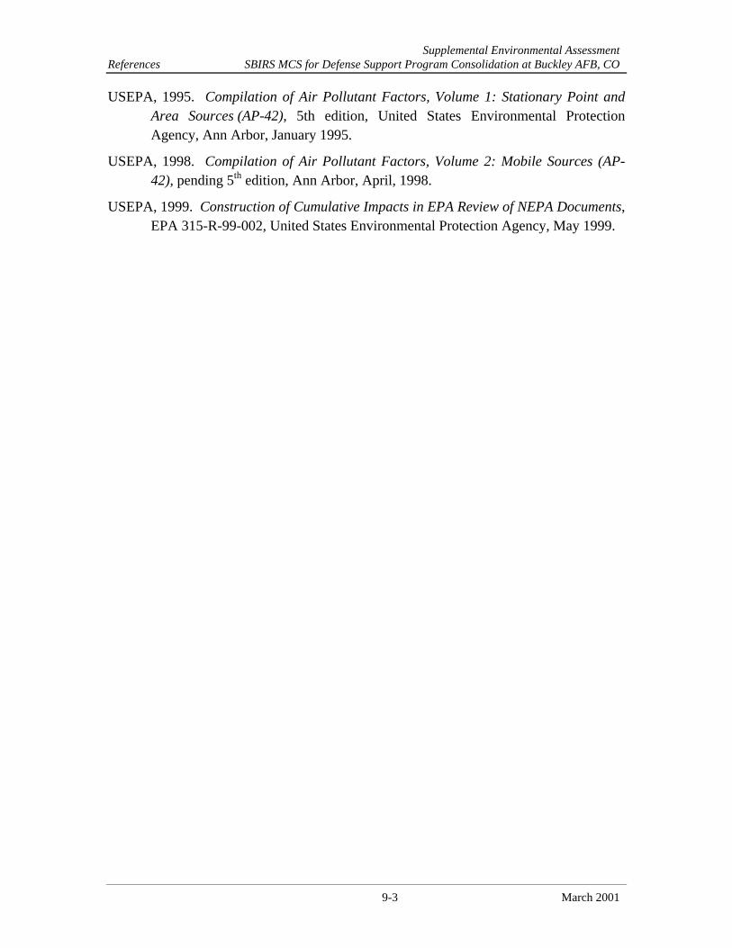
Supplemental Environmental AssessmentReferences SBIRS MCS for Defense Support Program Consolidation at Buckley AFB, CO
9-3 March 2001
USEPA, 1995. Compilation of Air Pollutant Factors, Volume 1: Stationary Point andArea Sources (AP-42), 5th edition, United States Environmental ProtectionAgency, Ann Arbor, January 1995.
USEPA, 1998. Compilation of Air Pollutant Factors, Volume 2: Mobile Sources (AP-42), pending 5th edition, Ann Arbor, April, 1998.
USEPA, 1999. Construction of Cumulative Impacts in EPA Review of NEPA Documents,EPA 315-R-99-002, United States Environmental Protection Agency, May 1999.

Supplemental Environmental AssessmentReferences SBIRS MCS for Defense Support Program Consolidation at Buckley AFB, CO
9-4 March 2001
THIS PAGE INTENTIONALLY LEFT BLANK

A-1
APPENDIX AAIR FORCE FORM 813
ENVIRONMENTAL IMPACT ANALYSIS

A-2
THIS PAGE INTENTIONALLY LEFT BLANK
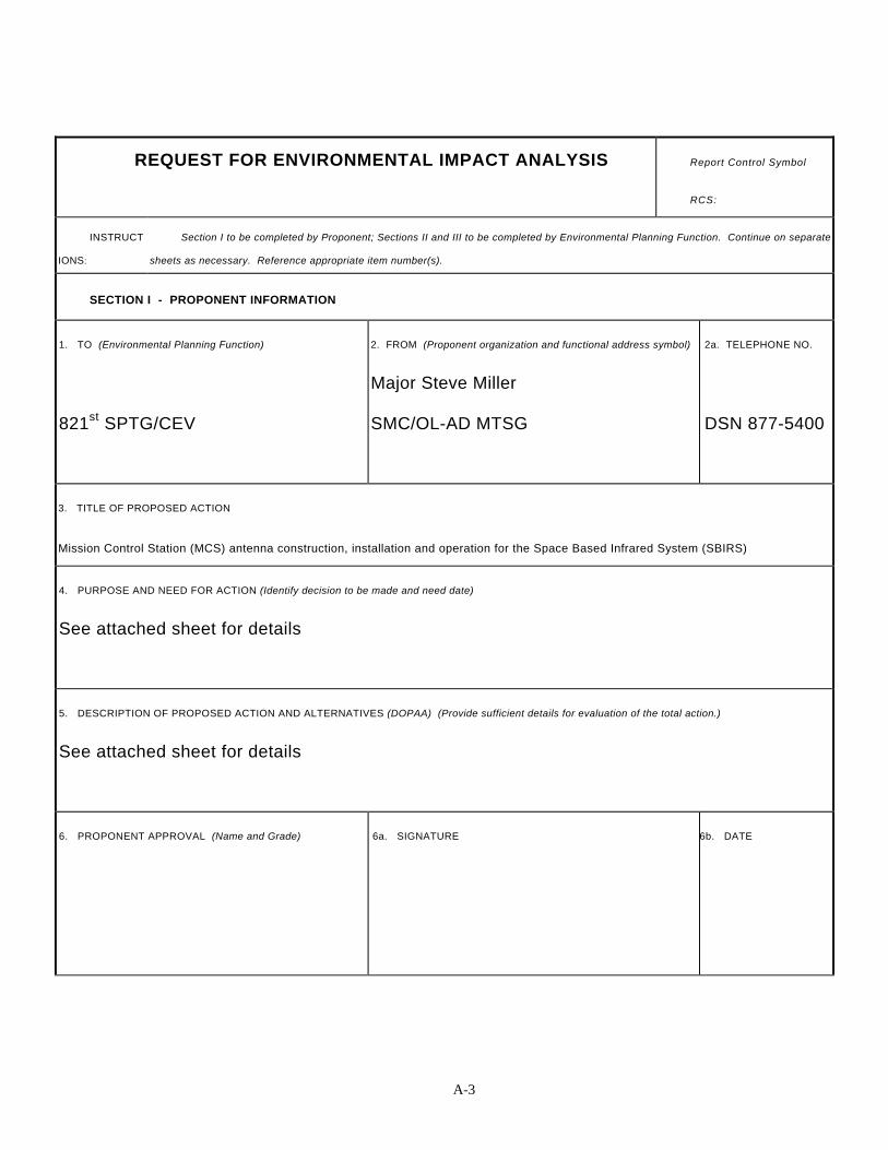
A-3
REQUEST FOR ENVIRONMENTAL IMPACT ANALYSIS Report Control Symbol
RCS:
INSTRUCT
IONS:
Section I to be completed by Proponent; Sections II and III to be completed by Environmental Planning Function. Continue on separate
sheets as necessary. Reference appropriate item number(s).
SECTION I - PROPONENT INFORMATION
1. TO (Environmental Planning Function)
821st SPTG/CEV
2. FROM (Proponent organization and functional address symbol)
Major Steve Miller
SMC/OL-AD MTSG
2a. TELEPHONE NO.
DSN 877-5400
3. TITLE OF PROPOSED ACTION
Mission Control Station (MCS) antenna construction, installation and operation for the Space Based Infrared System (SBIRS)
4. PURPOSE AND NEED FOR ACTION (Identify decision to be made and need date)
See attached sheet for details
5. DESCRIPTION OF PROPOSED ACTION AND ALTERNATIVES (DOPAA) (Provide sufficient details for evaluation of the total action.)
See attached sheet for details
6. PROPONENT APPROVAL (Name and Grade) 6a. SIGNATURE 6b. DATE
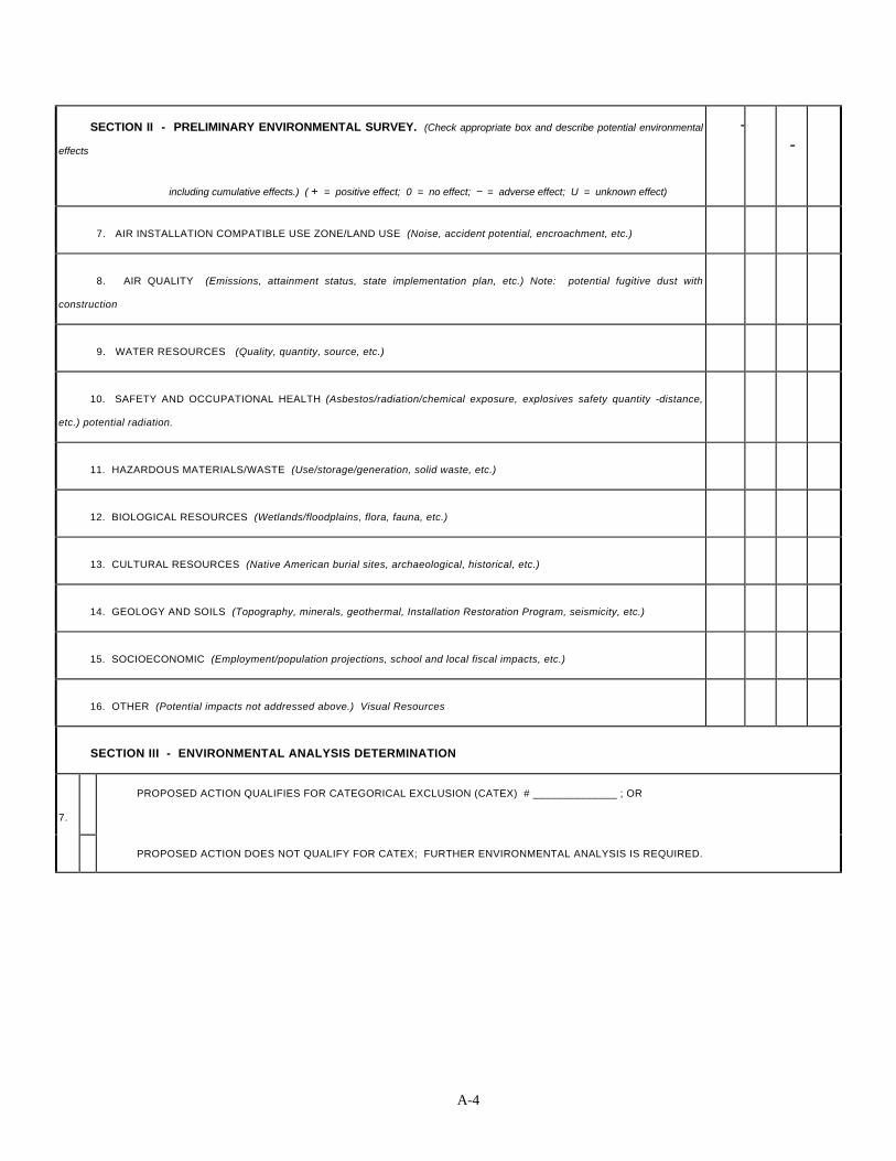
A-4
SECTION II - PRELIMINARY ENVIRONMENTAL SURVEY. (Check appropriate box and describe potential environmental
effects
including cumulative effects.) ( + = positive effect; 0 = no effect; -- = adverse effect; U = unknown effect)
+-
7. AIR INSTALLATION COMPATIBLE USE ZONE/LAND USE (Noise, accident potential, encroachment, etc.)
8. AIR QUALITY (Emissions, attainment status, state implementation plan, etc.) Note: potential fugitive dust with
construction
9. WATER RESOURCES (Quality, quantity, source, etc.)
10. SAFETY AND OCCUPATIONAL HEALTH (Asbestos/radiation/chemical exposure, explosives safety quantity -distance,
etc.) potential radiation.
11. HAZARDOUS MATERIALS/WASTE (Use/storage/generation, solid waste, etc.)
12. BIOLOGICAL RESOURCES (Wetlands/floodplains, flora, fauna, etc.)
13. CULTURAL RESOURCES (Native American burial sites, archaeological, historical, etc.)
14. GEOLOGY AND SOILS (Topography, minerals, geothermal, Installation Restoration Program, seismicity, etc.)
15. SOCIOECONOMIC (Employment/population projections, school and local fiscal impacts, etc.)
16. OTHER (Potential impacts not addressed above.) Visual Resources
SECTION III - ENVIRONMENTAL ANALYSIS DETERMINATION
7.
PROPOSED ACTION QUALIFIES FOR CATEGORICAL EXCLUSION (CATEX) # ______________ ; OR
PROPOSED ACTION DOES NOT QUALIFY FOR CATEX; FURTHER ENVIRONMENTAL ANALYSIS IS REQUIRED.
A-5
18. REMARKS
19. ENVIRONMENTAL PLANNING FUNCTION CERTIFICATION
(Name and Grade)
GERALD O’BRIAN, GS 12
19a. SIGNATURE 19b. DATE
AF FORM 813, AUG 93 (EF-V1) (Computer Generated) THIS FORM CONSOLIDATES AF FORMS 813 AND 814.
PAGE OF PAGE(S)
PREVIOUS EDITION IS OBSOLETE

A-6
THIS PAGE INTENTIONALLY LEFT BLANK

A-7
4.0 PURPOSE AND NEED FOR ACTION
4.1 Purpose of the Action:
The Space and Missile Systems Center (SMC) Space Based Infrared SystemsDirectorate (SBIRS), proposes to erect two radio frequency antennas (SB1 and SB2)as part of the SBIRS High Geosynchronous Satellite Program and three radiofrequency antennas as part of the SBIRS Low Earth Orbit (LEO) Satellite Program.These antennas would be part of the SBIRS Mission Control Station (MCS) facilityon the western side of Buckley AFB, Colorado. This document describes the antennainstallation actions only, which are supplemental to two previously writtenEnvironmental Assessments (EA's) referenced below (ref. 1 and 2). The SBIRSMission Control Station (MCS) site has been previously analyzed in an EA with aFinding of No Significant Impact (FONSI) completed by the EnvironmentalProtection Committee at Buckley ANGB on 12 April 1996. The two GEO antenna,SB1 and SB2, are enclosed in radomes. SB1 and SB2 are capable to transmit andreceive data and would be constructed on radome foundations, with grounding andsignal duct banks to interface with the cable duct bank attached to the MCS facility.The other LEO antennas are to be erected at the same location in the future andshould be addressed in future EIAP actions when their operating parameters havebeen established.
4.2 Need for the Action:
All of the proposed antennas are to be used to receive data for use by the GroundTerminal Element Segment (GTES) part of the MCS to accomplish the four SBIRSmissions. As stated above, SB1 and SB2 have transmitter and receive capabilities,whereas the three LEO antennas need future operating parameter definition. TheSBIRS missions include enemy missile warning, missile defense, technicalintelligence and battlespace characterization. As covered in the EA of 1996 (ref. 1),these missions are vital to the early warning capability for the U. S. national defensesystem of the future. As stated above, all of the radio frequency antennas are anintegral part of the MCS, which are to be utilized by SBIRS personnel. The MCSfacility and its associated antennas are to be used by the SBIRS GEO GroundSegment team with unique assets to provide a highly capable, cost effective, low risksatisfaction of the SBIRS mission. SB1 and SB2 are to be capable of bothtransmitting data and receiving data from the future SBIRS geosynchronous orbit(GEO) satellites as well as the Defense Satellite Program (DSP) fly-out satellites.The MCS and associated antennas will allow consolidation of three DSP operationalsites and associated communication networks into a fully integrated ground segmentthat fuses all IR data collected from space with other data to optimize performance

A-8
for all SBIRS missions. When fully operational, the SBIRS LEO satellites willprovide data to the LEO antennas that can be fused with SBIRS GEO satellite datafrom SB1 and SB2 and processed by the GTES MCS.
5.0 DESCRIPTION OF PROPOSED ACTION AND ALTERNATIVES
The Space Based Infrared System (SBIRS) is a team of government and industryprofessionals providing the nation a space based surveillance capability that has beenvital to U.S. defense over the past 30 years. The Defense Support Program (DSP),fielded in 1970, with antenna already located on Buckley AFB, has evolved into itsnext-generation Space Based Infrared High and Low systems that are intended tomeet nuclear threats predicted for the new century.
5.1 Proposed Action:
Figure 1 shows Buckley AFB and its vicinity to Denver, Colorado. Figure 2shows the planned locations of the new MCS antenna on Buckley AFB. Figure 3shows the planned locations of SB1, SB2 and the possible future location of threeLEO antennas adjacent to SB1 and SB2. Note that the SBIRS Mission ControlStation (MCS) is located just east of the proposed site for SB1 and SB2 as well as thethree LEO antennas. The MCS complex (including antennas) are located on thewestern side of Buckley AFB as shown in Figure 1. The details of the utilityconnections are shown in Figure 4. The SB1 and SB2 antenna radome structure isshown in Figure 5.

A-9
Figure 1 - Buckley AFB Near Denver, Colorado

A-10
Figure 2 - Site Location for MCS Antenna

A-11
Figure 3 - Antenna Siting of SB1, SB2 and Three (possible) FutureLEO Antennas

A-12
Figure 4 - SB1 and SB2 Site Utilities
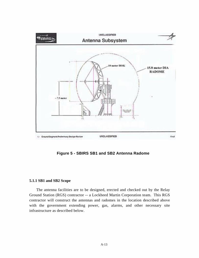
A-13
Figure 5 - SBIRS SB1 and SB2 Antenna Radome
5.1.1 SB1 and SB2 Scope
The antenna facilities are to be designed, erected and checked out by the RelayGround Station (RGS) contractor -- a Lockheed Martin Corporation team. This RGScontractor will construct the antennas and radomes in the location described abovewith the government extending power, gas, alarms, and other necessary siteinfrastructure as described below.

A-14
5.1.2 Antenna Land Use and Infrastructure/Utilities:
SBIRS proposes the construction of SB1 at coordinates 2202796.72 E,686155.54 N and SB2 at coordinates 2202796.72 E, 686055.54N. The physicalfacility requirements as presented in this section describe two ten meter diameterantenna that are inside fifty-two (52) foot air-supported radome structures withrelated electronic equipment as shown in Figure 5. Also shown in Figure 5 is thelocation of the antenna beam center designed to be approximately 25 feet above theantenna base. In addition, there will be three small SBIRS low antennas erected inthe future at the same general MCS location as shown in Figure 3. These threesmaller antennas will be constructed on concrete pads approximately 10 feet by 10feet.
The location of all of these antennas is in an area that is approximately 400 feetby 800 feet west of the MCS as shown in Figure 3. As with the recent MCSconstruction, the antennas’ site has been previously disturbed for construction ofWW I and WW II barracks facilities. All external electrical and utility interfaceconnections to these antenna facilities are underground to the maximum extentpossible. The detailed locations of these utilities are shown in Figure 4. Theconstruction of the foundation for SB1 and SB2 is, at this point in time, is expectedto follow the following schedule:
17 July 99 - Design of Foundation Complete
1 Aug 99 - Final Facility Interface Control Documentation
1 Dec 00 - Start Antennas Foundation Construction
1 July 01 - Complete Antennas Foundation Construction
15 August 01 - Complete Antennas Construction
In addition to Figure 4, the utility connections for the antenna foundations aremore fully described in the table below:
Interface Distance from UtilitySource to Antenna
Reference Comment
Electrical 150 ft. East - Northeast of Antenna SB1.Stub four conduits (4 inch) to westfor low voltage switches for eachantenna.
GFE power shall be availableat the cold side of breakers incross-tied panels for SB1 andSB2 Utility and Technicalsupplies.
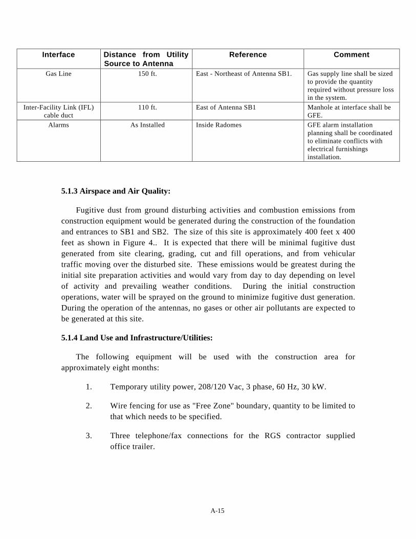
A-15
Interface Distance from UtilitySource to Antenna
Reference Comment
Gas Line 150 ft. East - Northeast of Antenna SB1. Gas supply line shall be sizedto provide the quantityrequired without pressure lossin the system.
Inter-Facility Link (IFL)cable duct
110 ft. East of Antenna SB1 Manhole at interface shall beGFE.
Alarms As Installed Inside Radomes GFE alarm installationplanning shall be coordinatedto eliminate conflicts withelectrical furnishingsinstallation.
5.1.3 Airspace and Air Quality:
Fugitive dust from ground disturbing activities and combustion emissions fromconstruction equipment would be generated during the construction of the foundationand entrances to SB1 and SB2. The size of this site is approximately 400 feet x 400feet as shown in Figure 4.. It is expected that there will be minimal fugitive dustgenerated from site clearing, grading, cut and fill operations, and from vehiculartraffic moving over the disturbed site. These emissions would be greatest during theinitial site preparation activities and would vary from day to day depending on levelof activity and prevailing weather conditions. During the initial constructionoperations, water will be sprayed on the ground to minimize fugitive dust generation.During the operation of the antennas, no gases or other air pollutants are expected tobe generated at this site.
5.1.4 Land Use and Infrastructure/Utilities:
The following equipment will be used with the construction area forapproximately eight months:
1. Temporary utility power, 208/120 Vac, 3 phase, 60 Hz, 30 kW.
2. Wire fencing for use as "Free Zone" boundary, quantity to be limited tothat which needs to be specified.
3. Three telephone/fax connections for the RGS contractor suppliedoffice trailer.

A-16
5.1.5 Socioeconomics and Environmental Justice:
The ROI for socioeconomics activities at Buckley Air Force Base is the Denvermetropolitan area that includes the five counties of Adams, Arapahoe, Denver,Douglas and Jefferson. The baseline socioeconomics environment is described fullyon pages 3-9 through 3-14 of the Environmental Assessment (EA) for Buckley AirNational Guard Base Realignment (ref. 4). The antenna site will not be manned byany personnel and will only be maintained by a small number of personnel.
The ROI for Environmental Justice has also been reported in the EnvironmentalAssessment referenced above. As described in the EA, on 11 Feb 94 PresidentClinton issued Executive Order 12898, Federal Actions to Address EnvironmentalJustice in Minority and Low-Income Populations. The purpose of this order is toavoid the disproportionate placement of any adverse environmental or economicimpacts from a proposed action on minority and low-income populations. The EAbaseline analysis has shown zip code 80239 to have a disproportionately highminority population.
5.1.6 Visual and Aesthetic Resources:
In addition to the two radomes that enclose SB1 and SB2, there is to be afreestanding anemometer tower erected for the antenna pressurization control system.The RGS Contractor provides this 30-foot tower and is located approximately 130feet northwest of the center of SB1 shown in Figure 2. The Inter-Facility Link (IFL)provides signal cable access between the antennas and the MCS. The IFL consists ofsix each four inch diameter schedule 40 PVC conduits encased in reinforcedconcrete. Three conduits are used for each antenna with a pull line. The IFL willinterface with the duct bank located on the west side of Eldora Road at a manholelocated east of SB1 as shown in Figure 3.
5.1.7 Public Health and Radiation Safety:
The two new antennas, SB1 and SB2, transmit radio frequency (RF) emissions inthe non-ionizing portion of the electromagnetic energy spectrum. There are threesafety hazards associated with this type of energy – personnel hazard, accidental fuelignition/combustion hazard and accidental ordinance ignition hazard. In the case ofpersonnel hazards, high power transmitting RF fields can be potentially debilitatingby causing heating to human eyes and gonads. The radiation guidelines for thepersonnel hazard as well as the other two hazards are more fully described in T.O.31Z-10-4, Electromagnetic Radiation Hazards, IEEE c95.1, Standard for SafetyLevels, and AFM 91-201, Explosive Safety Standards. The Joint Spectrum Center, anactive participant in SMC's and other government groups' spectrum management

A-17
activities, for the antennas SB1 and SB2 conducted a recent study funded by theSBIRS Program Office. The results of the study showed that none of the abovesafety hazard guidelines would be violated for the SBIRS proposed action ofinstalling and operating SB1 and SB2. The details of this study are in a report whichhas been verified by Capt. Michael Brox, SMC/MT. Capt. Michael Brox also has amemo stating the environmental compliance of SB1 and SB2 to radio frequencyemission guidelines. In addition, the Aerospace Corporation has performed a studythat shows the energy hazard areas for SB1 and SB2. Figure 6 shows the Aerospaceenergy hazard simulation geometry scenario. Power density levels along the antennaaxis, along the antenna rim and 6 feet above the ground have been calculated and areshown in figure 7. In these plots as well as results from a similar contractor study(see attached), the power density levels are 3 mW/cm2 or less. In locations aroundSB1 where there will be personnel, the power density level is less than 1 mW/cm2.As stated in the attached JSC memo, no energy hazard, cumulative or otherwise, isexpected to be created by constructing SB1 or SB2. This has been confirmed by theother two independent studies as well.
Since the SBIRS low antenna will further define its operating parameters overthe next few years, there needs to be a continued examination of the potential RFenergy hazards at the MCS antenna site.
Figure 6 - SB1 and SB2 Rad Hazard Simulation Geometry

A-18
Figure 7 - SBIRS Energy Power Density Curve

A-19
5.2 Supporting Documents:
Reference 1. Environmental Assessment, Space Based Infrared System (SBIRS)Mission Control Station for Defense Support Program Consolidation; United StatesAir Force Headquarters Space and Missile Systems Center, Buckley ANGB,Colorado; April 1996.
Reference 2. Overview Environmental Assessment for Space Based InfraredSystem (SBIRS); United States Air Force Headquarters Space and Missile SystemsCenter; January 1997.
Reference 3. The MCS Facility Installation Standard, 29 Mar 98, P457038
Reference 4. Environmental Assessment (EA) for Buckley Air National GuardBase Realignment, prepared for U. S. Air Force Space Command by the HeadquartersAir Force Center for Environmental Excellence Environmental Analysis Division,Brooks Air Force Base, TX in September 2000.
5.3 No Action Alternative:
The only alternative identified would be to allow the MCS to operate only withthe existing DSP antennas. The environmental impact from the No ActionAlternative, which is not to build the antennas for the MCS, is expected to be similarto the Proposed Action, which has insignificant environmental impact.

A-20
THIS PAGE INTENTIONALLY LEFT BLANK

B-1
APPENDIX BSBIRS ANTENNA STUDY RESULTS
BY THE AEROSPACE CORPORATION

B-2
THIS PAGE INTENTIONALLY LEFT BLANK

B-3
Appendix B - SBIRS Antenna Study Results
B.1 NON-IONIZING ENERGY HAZARDS
Radio frequency (RF) electromagnetic energy is generated by satellitecommunications equipment located within the 2 SWS facility at Buckley AFB. Thissection describes the RF equipment and potential impacts associated with the twonew SBIRS communications antennas, SB1 and SB2, proposed to be constructed atthe locations on Buckley AFB shown in Figures 1 and 2. The existing antennaswould be used for communication with satellites on an interim basis and ultimatelywould be replaced by the SBIRS satellite communication system using the SB1 andSB2 antennas associated with the SBIRS MCS. Although plans for future SBIRSLEO antenna construction near the MCS are not final, their environmental impactwill also be discussed.
B.2 Construction of SB1 and SB2 and Future LEO Antennas
The two new SBIRS "high" antennas, to be constructed at the locations shown inFigure 1, transmit RF emissions in the non-ionizing portion of the electromagneticenergy spectrum. There are three safety hazards associated with this type of energy:personnel hazards, accidental fuel ignition/combustion hazards, and accidentalordnance ignition hazards. The RF emission power levels required for fuelignition/combustion are much higher (5000 mW/cm2) than can be achieved by any ofthe antennas studied.
In the case of personnel hazards, high-power transmitting RF fields can bepotentially debilitating by causing heating to human eyes and gonads. Accidentalordnance ignition hazard and other RF interference (RFI) hazards can cause safetyhazards to electrical explosive devices. The radiation guidelines for these energyhazards (RADHAZ) are more fully described in T.O. 31Z-10-4, ElectromagneticRadiation Hazards, IEEE c95.1, Standard for Safety Levels, and AFM 91-201,Explosive Safety Standards. The RADHAZ level of safety is time- and frequency-sensitive. For short-duration exposures, the lower threshold, below which personnelare considered safe from a nonionizing RADHAZ, is 10 mW/cm2. However, the"worst case" lower limit for continuous (24 hours/day, 7 days/week) exposure to allareas of the body or to any type of electrically activated explosive devices is 1mW/cm2.
SBIRS proposes the construction of SB1 at coordinates 2202796.72 E, 686155.54 Nand SB2 at coordinates 2202796.72 E, 686055.54N. The physical facility requirements,

B-4
as presented in AF Form 813, include two ten-meter (33-foot) diameter antennas that areinside fifty-two (52) foot, air-supported radome structures with related electronicequipment, as shown in Figure 2. Also, shown in Figure 2, is the location of theantenna beam center, which is designed to be approximately 25 feet above theantenna base. In addition, there will be three small SBIRS low antennas erected inthe future at the same general MCS location as shown in Figure 3. These threesmaller antennas will be constructed on concrete pads approximately 10 feet by 10feet. For this assessment, these antennas are to have the specifications ascribed toLEO-1, LEO-2 and LEO-3 shown in table 1 below.
AntennaLocation
AntennaDiameter
(feet)
TransmitFrequency
(GHz)
TransmitPower(Watts)
MaximumOperational Time
(days/wk, hours/day)
MinimumOperational
ElevationAngle
(degrees)LEO1 10 45 20 7 days/wk, 24 hrs/day 5LEO2 10 45 20 7 days/wk, 24 hrs/day 5LEO3 10 45 20 7 days/wk, 24 hrs/day 5D1 60 1.8 5000 7 days/wk, 24 hrs/day 5D2 60 1.8 5000 7 days/wk, 24 hrs/day 5D3 33 Receive -
only2000 Backup N/A
SB1 33 1.8 2000 7 days/wk, 24 hrs/day 5SB1 33 45 20 7 days/wk, 24 hrs/day 5SB2 33 1.8 2000 7 days/wk, 24 hrs/day 5SB2 33 45 20 7 days/wk, 24 hrs/day 5
Table 1. SBIRS Antenna Operational Parameters
The antenna facilities for SB1 and SB2 would be designed, erected and checkedout by the Relay Ground Station (RGS) contractor -- a Lockheed Martin Corporationteam. The RADHAZ has already been assessed by this contractor with a studyconcluding that there would be no personnel or RFI RADHAZ introduced into theBuckley environment. In addition, two recent RADHAZ studies of antennas like SB1and SB2 have been conducted by the Joint Spectrum Center; 120 Worthington Basin,Annapolis, MD, 21402-5064. The Joint Spectrum Center studies also concluded thatthere will be no unacceptable personnel or RFI RADHAZ introduced by theconstruction of SB1 and SB2.
Using the parameters in Table 1, the results of a recent Aerospace simulation aregiven below.
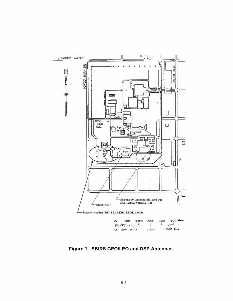
B-5
Figure 1. SBIRS GEO/LEO and DSP Antennas

B-6
Figure 2 - SBIRS SB1 and SB2 Antenna Disk andRadome

B-7
Figure 3 - Antenna Siting of SB1, SB2 and Three Future LEOAntennas

B-8
B.3 - SBIRS and DSP Antenna Comparisons
An alternative to the primary option described above, would be to allow the MCSto operate only with the existing antennas D1, D2 and D3. This would requiremodifications to D1, D2 and D3, or in other words, to not construct SB1 and SB2 orthe future LEO antennas. This option is not realistic because the new SBIRS Highsatellites will need SB1 and SB2 as a requirement for operation. Nevertheless, theenvironmental RADHAZ impact from this option is expected to be similar to theaction discussed in AF Form 813, and as described in this section. The AerospaceCorporation has performed a study that shows the RADHAZ for SB1 and SB2compared to the existing D1, D2, and D3 (D3 is a receive-only, backup antenna),shown in Figure 1. This study also shows preliminary expected values from the LEOantenna even though these antennas are several years away from being designed andconstructed. As shown below, there currently are no RADHAZ associated with D1,D2 and D3 and none is expected from the construction and operation of SB1, SB2,LEO1, LEO2, and LEO3.
Figure 4 shows the Aerospace RADHAZ simulation geometry for examining theantennas. The simulated plots shown in Figures 5 and 6, show power density levelsalong three geometrical paths. The first path is along the antenna axis centerline, thesecond is extending away from the antenna rim, and the third is six feet above theground in the direction the antenna is pointing. This latter configuration assumes a"worst case two-dimensional pointing angle" condition. This condition is defined asthe case where the antenna is pointed at its lowest elevation angle of 5º degreesabove the horizon. This is the "worst case" in the sense that it delivers the mostpower to the ground as is possible. In actual operation, the antenna will deliver lesspower to the ground than this "worst case" because it will be pointed at an anglehigher than 5º degrees.
In comparing Figures 5 and 6 several conclusions can be reached. First, thecurves plotted in green on both figures refer to S-Band energy power density levelspredicted six feet above the ground around each antenna at distances given in feetfrom the antenna. Note that the "green path" power density levels (ground values) arevery similar for SB1/SB2 (Figure 5) and D1/D2 (Figure 6) as the energy emanatesaway from the vertex of the antenna. More importantly, note that these levels aremore than 100 times below the "worst case" allowable RADHAZ exposure levels of 1mW/cm2 at all ground locations around the MCS.
Second, the red plots in Figures 5 and 6 show power levels at the beam edge oralong the rim of a vector extending out from the rim of the antenna as shown inFigure 4. These power levels are also below 1 mW/cm2 and are power levels that

B-9
will be reached only at significant heights above the ground. Also note that as thedistance away from the antenna vertex increases, the height also increases, as showngeometrically in Figure 4.
Ground
AntennaHeight
Height Above Ground = 6 feet
Antenna
Emission Along Axis
Emission Along Rim
Elevation AngleMin = 5º
Emission Along Ground
Vertex of Antenna Projected to Ground
Figure 4 - Antenna Calculation Geometry
Third, the black plots in Figures 5 and 6 show the maximum power levelsreached in the center portion of the beam. For the action discussed in AF Form 813,all S-Band power levels are below 10 mW/cm2 at all distances from the vertex of theantenna. This is not currently true for D1 and D2 which go up to approximately 10mW/cm2 in the center of the beam at distances less than 100 feet. This does not implythat any unacceptable hazards exist from D1 or D2, but demonstrates that SB1 andSB2 generate a safer energy power level along the beam axis, one that is lower thanthe D1 and D2.
Figures 7 and 8 show the power levels of the future SBIRS LEO antennas usingQ-band transmit powers listed in Table 1. Figure 7 shows that in all parts of thetransmit beam, SB1 and SB2 are below 1 mW/cm2 and cannot introduce a RADHAZ.Figure 8 shows that in the main beam portion of LEO1, LEO2 and LEO3 out to adistance of 50 feet, there are small excursions above 1 mW/cm2. These areas must becontrolled access for future LEO operations to minimize environmental impact.Outside of the 50-foot area, the SBIRS LEO antennas introduce no RADHAZenvironmental risk.

B-10
Figure 5- RF Power Density Levels From S-Band SB1/SB2

B-11
Figure 6 - RF Power Density Levels From S-Band DB1/DB2

B-12
Figure 7 - RF Power Density Levels From Q-band SB1/SB2 Antennas
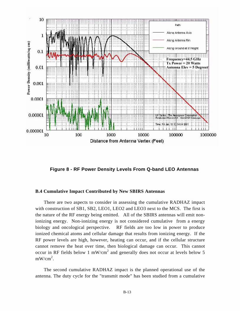
B-13
Figure 8 - RF Power Density Levels From Q-band LEO Antennas
B.4 Cumulative Impact Contributed by New SBIRS Antennas
There are two aspects to consider in assessing the cumulative RADHAZ impactwith construction of SB1, SB2, LEO1, LEO2 and LEO3 next to the MCS. The first isthe nature of the RF energy being emitted. All of the SBIRS antennas will emit non-ionizing energy. Non-ionizing energy is not considered cumulative from a energybiology and oncological perspective. RF fields are too low in power to produceionized chemical atoms and cellular damage that results from ionizing energy. If theRF power levels are high, however, heating can occur, and if the cellular structurecannot remove the heat over time, then biological damage can occur. This cannotoccur in RF fields below 1 mW/cm2 and generally does not occur at levels below 5mW/cm2.
The second cumulative RADHAZ impact is the planned operational use of theantenna. The duty cycle for the "transmit mode" has been studied from a cumulative

B-14
environmental impact assessment perspective for antennas SB1, SB2, D1, D2, D3,LEO1, LEO2, and LEO3. The duty cycle consists of two elements, the time, orduration, that the transmission is occurring and the angular pointing aspect of theoperational antenna. Regarding the duration of transmission, the worst-caseassumption of "continuous transmission" has been assumed as described above. Inthe case of angular pointing aspect, unlike radar antenna which continuouslytransmit in many directions, the SBIRS "command and control" antennas would befixed at a few locations and used to transmit signals in the direction of one particularsatellite at a time. This means that there will be no time when more than one antennais pointed at the same location in space. Therefore, the arithmetic addition of theenergy fields is not a consideration in assessing the cumulative RADHAZ.
Therefore, as stated in the other studies referenced in this supplemental EA, nounacceptable energy hazard, cumulative or otherwise, is expected from constructingSB1 or SB2 or the future LEO antennas. At all ground and air locations around SB1,SB2, D1, D2 and D3, the power density levels are expected to be within acceptablelevels.

C-1
APPENDIX CDoD JOINT SPECTRUM RADIATION HAZARD ASSESSMENT

C-2
THIS PAGE INTENTIONALLY LEFT BLANK
C-3
21 NOVEMBER 2000
MEMORANDUM FOR SPACE AND MISSILE CENTER
TO: MR. DANIEL PARK (SMC/AXF)
SUBJECT: RADIATION HAZARD ASSESSMENT SUMMARY ATPROPOSED SBIRS HIGH MCS, BUCKLEY AFB, CO
BACKGROUND
The planned installation of the Space Based Infrared System (SBIRS) MissionControl Station (MCS) at Buckley Air Force Base (BAFB) (formally Buckley AirNational Guard Station) in Aurora Colorado raised concerns regarding the potential forradiation hazard conditions from collocated satellite earth terminals. As a result, the DoDJoint Spectrum (JSC) was requested to conduct radiation hazard measurements at theproposed SBIRS High MCS antenna locations. Testing was conducted in theOctober/November 1998 timeframe.
OBJECTIVE
The objective of the measurement effort was to determine the maximumelectromagnetic radiation (EMR) levels and the associated radiation hazard potential atthe planned SBIRS MCS from collocated satellite ground terminals (SGTs).
APPROACH
The EMR levels from the collocated satellite earth terminals were measured using aspectrum analyzer and a broadband horn antenna coupled to laptop PC. Themeasurement antenna was mounted to a tripod that was anchored to a man-lift bucket andthen raised to a height of 54 feet. This elevation corresponded to the expected height ofthe top of the SBIRS radome, the point at which the highest EMR levels on the SBIRSMCS facility were expected.
Measurements were conducted with the SGTs operating in the manual mode with theterminals set to radiate an unmodulated CW signal. Measurements were taken with thetransmitter power levels at both nominal and maximum levels. To ensure identificationof the maximum signal level, the SGT antenna was first directed to a pre-calculatedazimuth/elevation pointing angle that corresponded to the measurement location (the
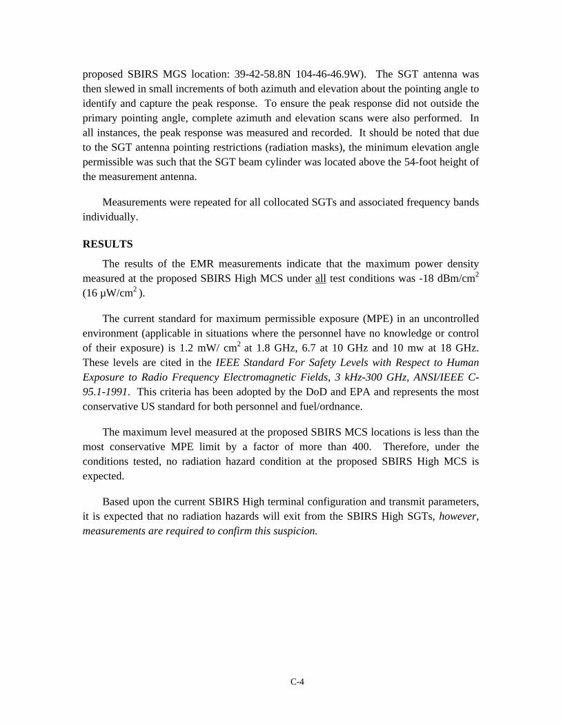
C-4
proposed SBIRS MGS location: 39-42-58.8N 104-46-46.9W). The SGT antenna wasthen slewed in small increments of both azimuth and elevation about the pointing angle toidentify and capture the peak response. To ensure the peak response did not outside theprimary pointing angle, complete azimuth and elevation scans were also performed. Inall instances, the peak response was measured and recorded. It should be noted that dueto the SGT antenna pointing restrictions (radiation masks), the minimum elevation anglepermissible was such that the SGT beam cylinder was located above the 54-foot height ofthe measurement antenna.
Measurements were repeated for all collocated SGTs and associated frequency bandsindividually.
RESULTS
The results of the EMR measurements indicate that the maximum power densitymeasured at the proposed SBIRS High MCS under all test conditions was -18 dBm/cm2
(16 µW/cm2 ).
The current standard for maximum permissible exposure (MPE) in an uncontrolledenvironment (applicable in situations where the personnel have no knowledge or controlof their exposure) is 1.2 mW/ cm2 at 1.8 GHz, 6.7 at 10 GHz and 10 mw at 18 GHz.These levels are cited in the IEEE Standard For Safety Levels with Respect to HumanExposure to Radio Frequency Electromagnetic Fields, 3 kHz-300 GHz, ANSI/IEEE C-95.1-1991. This criteria has been adopted by the DoD and EPA and represents the mostconservative US standard for both personnel and fuel/ordnance.
The maximum level measured at the proposed SBIRS MCS locations is less than themost conservative MPE limit by a factor of more than 400. Therefore, under theconditions tested, no radiation hazard condition at the proposed SBIRS High MCS isexpected.
Based upon the current SBIRS High terminal configuration and transmit parameters,it is expected that no radiation hazards will exit from the SBIRS High SGTs, however,measurements are required to confirm this suspicion.

D-1
APPENDIX DDRAFT EA COMMENT LETTERS

D-2
THIS PAGE INTENTIONALLY LEFT BLANK