SUMMARY WORK RPT STONEY CREEK PROJ MISHIBISHU … · available to the belt via a gravel road from...
18
l l l l l l l l l l l l l l l l l l l 42ce4seeei2 a . 1 3072 DAVID LAKES 010 2. 13072 NORANDA EXPLORATION COMPANY, LIMITED (no personal liability) SUMMARY WORK REPORT STONEY CREEK PROJECT MISHIBISHU AREA NTS 42 C/14 NORTHWESTERN ONTARIO DIVISION January 18, 1990 Hamlo, Ontario Tewolde Woldsabzghi Geologist
Transcript of SUMMARY WORK RPT STONEY CREEK PROJ MISHIBISHU … · available to the belt via a gravel road from...

l l l l l l l l l l l l l l l
l
l l l
42ce4seeei2 a . 1 3072 DAVID LAKES 010
2. 13072
NORANDA EXPLORATION COMPANY, LIMITED (no personal liability)
SUMMARY WORK REPORT
STONEY CREEK PROJECTMISHIBISHU AREA
NTS 42 C/14
NORTHWESTERN ONTARIO DIVISION
January 18, 1990 Hamlo, Ontario
Tewolde Woldsabzghi Geologist

l l l l l l l l l l l l l l l l l l l
1.0
2.0
3.0
4.0
5.0
6.0
42C84SE8812 2,13072 DAVID LAKES 010C
TABLE OF CONTENTS
Introduction
Pag e
, l
Location t* Access................................. l
Property Description.............................. l
Property Geology. ........................,........ 2
Geological Prospecting and Mapping................ 2
Conclusions and Recommendat ions................... 3

l l l l l l l l l l l l l l l l l l l
1.0 INTRODUCTION: ( Figure 1)
The Stoney Creek property is located immediately north of
the Mishibishu greenstone belt near Wawa, Ontario, and consists
of a group of 60 contiguous claims. An agreement was reached on
September 19, 1989 that Noranda Exploration, Ltd. will operate
the project on behalf of Central Crude and Noront. The purpose
of the agreement is to explore for gold deposits in the area.
2.0 LOCATION AND ACCESS:
The Mishibishu Greenstone Belt is located immediately north
of Lake Superior, between Wawa and Hemlo. Road access is
available to the belt via a gravel road from Highway 17 (50 km
northwest of Wawa) to the vicinity of the Central Crude portal.
Property access is then best achieved by helicopter, as there are
few lakes suitable for float-equipped aircraft. Approximate
centre of claims is: North Latitude 43* 06' 10"
West Longitude 33* 35' 30"
3.0 PROPERTY DESCRIPTION: (Figure 2)
Tha Stoney Creek property consists of 60 contiguous
unpat3ntad mining claims located in the Mishibishu area in the
Sault 3 t e . 'Aar i c M ining Division. The claim numbers are:
S3M 1347355 - 1047373 and 33i 1047330 - 1047916
l

. j* isr~ M icmoieoit*. LAKE " I8na
Figure 1: Location man
l l l l l l l l l l l l l l l l l l l
4.0 PROPERTY GEOLOGY
The property is located within a large granitic batholith,
immediately north of the East Pukaskwa River and between the
Kabcnung Lake and Mishibishu greenstone belts. ^
The central part of the claim group consists mainly of
northeast trending 1200m wide trondhjemite. This weakly foliated
intrusive weathers white to pink - it contains essentially sub-i
euhedral crystals of feldspar (90?) with minor amounts of quartz
and amphi boles.
The "granitic" rocks to the northwest and southeast of the
trondhjemite intrusive are much more gneissic and foliated, they
also have a more complex mineralogical composition. As
elsewhere, diabase dykes are common.
The area contains numerous negative lineaments, most of
which trend southeast-northwest and northeast-southwest. No
shear zones have been observed within the lineaments - fracturing
coupled with erosion are their probable causes.
A few quartz veins containing minor amounts of pyrite,
chalcopyrite and tourmaline have been found within the
trondhjemite to data.
5.0 GEOLOGICAL PROSPECTING AND MAPPING
Geological prospecting and mapping was contracted by

1047912 .1047918
I047897||0478981I I04790PVU)47907] 1047910
10470901)047899 .1047901' 104790871^47908
1047088 1)047887 '(047890104790^1047913
1047094) I04780S
I0478D8 10478
1047888? 1047884*1047663 ,1047*62) 1047^61
1)04781?) 104787204^87^0] : l
1047088 11047874
CLAIM MAP
STONEY CREEK

MISHIBISHUIAJN ZONE
69 g/t^AGNACON ZONE
IIBISHU LAKE DEFORMATION ZONE
t HOKTHEHN
NO NAME LAKE DEFORMATION ZONEOIL CITY ^
MISHIBISHU BELT.mild
t KNOWN OOLO OCCURRENC
•iff. MAJOR GOLD OCCURRENCE
l l l l l l l l l l l l l l l l l l l
Noranda Exploration Company, Limited, to Bayshore Geology Inc. of
Thunder Bay, Ontario and conducted during September and early
October, 1939.
The objective of the survey was to follow up structural
features and geochemical anomalies to outline further zones of
interest.
As a result of the present survey two types of granite werei
identified in the property: a calcium feldspar and potassic
feldspar granite phases. Within them arc some narrow felsic
dykes and a variety of xenolith and assimilated and/or partly
\ assimilated mafic intrusives and me tasedimentary rocks.
Diabase dykes come in three types! a coarse grained, weakly
magnetic coarse grained, and fine grained phases.
Alteration is weak and only limited to joints and consisted
of potassic phase (orthoclase) and epidote.
6.0 CONCLUSIONS AND RECOMMENDATIONS
Overall the property is underlain essentially by two types
of granite calcium and pottasic-rich phases. The calcium
feldspar granite is by far tha most dominant rock type in the
area, with K-spar granite only occuring locally as rounded or
more often linear bodies. This mode of occurance suggests that
the potassium content could be an alteration product as opposed

l l l l
l l l l l l l l l l l
to a primary feature.
Lineaments are not indicative of major shear zones, but
they are structural in nature as they are parallel to and often
l host the diabase dykes. Quartz veins noted to date a r ex also
related to these lineaments, making them good targets for future
m e xploration programs.
B Further detailed exploration works including prospecting
and detail mapping is warranted along the linear potassium
feldspar granites as well as other structural lineaments in the
prope rt y.

l l l l l l l l l l l l l l l l
STATEMENT OF QUALIFICATIONS v
I, Tewolde Woldeabzghi of Lasalle, Quebec do hereby certify that:
1. I am a geologist residing at 8192 Jacqueline St., Lasalle, Quebec .
2. I am a graduate of Adis Aboba University, Ethiopia (1973) with the degree of Bachelor of Science (B. Se.) in Geological Sciences, and of McGill University, Montreal (1987) with the degree of Master of Science Applied' (M. Se. A.) in Earth Sciences.
3. I am a Fellow of the Association of Professional Geologists and Geophysi ci st s of Quebec.
4. I have practiced my profession for 14 years and supervised the work carried out in this report.
5. This report is based on my personal knowledge of the Mishibishu belt and^ review of fieldmaps, geological and geochemica l dat a ^c^^ojjfy^&a^rr ied out by Bayshore Geology Inc. of Thunder Bay, OnJ
Signature:
Name :
l
l
( Ministry ol Northern Development
Ontario
DOCUMENT NO W9005*-
X/ rt SI s- l J
Report of Work Mining Act (Geophysical, Geological and Geochemical Smvey&j
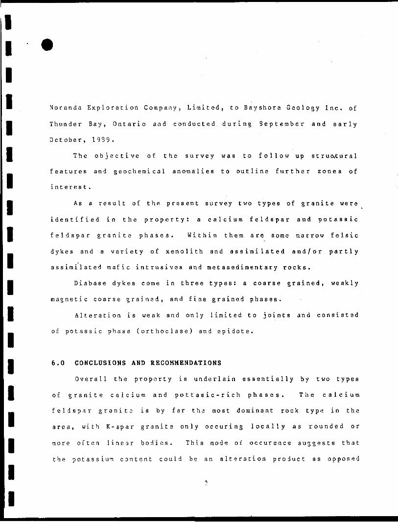
2.13072 OAV i AKES Minln8 Lanos Bection, 90O
Type of Surveys)
Geological SurveyRecorded Holder(s)
Central CrudeAddress
P.O. Box 2656.
Mining Division Sault Ste. Marie
Township or Area - t .
David Lakes Area C. L(JAU)4\
Limited RECEIVED
Thunder Bay, Ontario P7B 5G2 r en o n ww*
Prospector's Licence No.
T 1361Telephone No. 807-623-4339
Survey Company ' "" u * v l**'w'
Noranda Exploration Company, Limited * ..Name and Address of Author (of Gee-Technical Report) MINING LANDS SECTION
Tewolde Woldeabzehi. P.O. Box 2656, Thunder Bay, Ontario P7B 5G2Credits Requested per Each Claim in Columns at rightSpecial Provisions
For first survey:
Enter 40 days. (This includes line cutting)
For each additional survey: using the same grid:
Enter 20 days (for each)
Man Days
ergjr t6,tj^(s}.hVe[-{ 0
FEB 15 1990
IfrOipi' N!rt ,
E
Airborne Credits
Note: Special provisions credits do not apply to Airborne Surveys.
Geophysical
- Magnetometer
- Other
Geological
Geochemical
Geophysical
D
Gei
vacij
rfagnetorru
)ther
logical
chemical
netic
jter
Electromagnetic
Magnetometer
Other
Total miles flown over clalm(s).Date February 5/90
Recw*fj
^rtOsZ,
Days per Claim
20
Days per Claim
Days per Claim
td Holder or Agent Signature)
-
Mining Claims Traversed \Mining Claim
Prefix
SSM
. - .
Number
1047855
1047856
1047857
1047859
1047860
1047861
1047862
1047863
1047864
1047865
1047866
1047867
1047868
104786Q
1047870
in47R71
List in numerical
Date of Survey (froi
dfyl| *a9| -S9
i&to) Wi Wi. |89.
sequence)Mining Claim
Prefix
SSM
see
Number
1047872
1047873
1047874
1047875
1047876
1047877
1047878
1047880
1047881
1047882
1047883
1047884
1047885
1047886
1047887
Mining Claim
Prefix
SSM
...~..,-....
Number
1047888
1047889
1047890
1047891
1047892
1047893
1047894
1047895
1047896
1047897
1047898
1047899
1047900
1047901
1047902attached sheet
Total number of , mining claims covered by this report of work.
60Certification Verifying Report of Work
hereby certify that l have a personal and intimate knowledge of the facts set forth in this Report of Work, having performed the work or witnessed same during and/or Her its completion and annexed report is true.
Name and Address of Person CertifyingRonna F. Tergie, P.O. Box 2656, Thunder Bay, Ontario P7B 5G2
Telephone No.807-623-4339
Date
February 9,1990By (Signature:
Ree jived gla
For Office Use Only
Total Days Cr. Recorded
Date Recorded
Date Approved as Recorded
Mining Recorder
Provincial Manager, Mining
R E C E IV E D
FF8J51990A.M., ,. ^ ^ . . P.M.
1362 (69/06)

ning Claims (continued)
SSM.1047903
1047904
1047905
1047906
1047907
1047908
1047909
1047910
- 1047911
1047912
1047913
1047914
1047915
1047916

Ministry ofNorthern Developmentand Mines
Technical Assessment Work Credits
onlarloAnHl 20/1990
"""'2.13Q7Z
Central Crude LimitedTo wni hlp~or~Ar 4
Da vi H l
rype ci survey and number of Aaecment day* credit fur claim Mining Claim* AfMCMd
Geophysical
Electromagnetic .
Magnetometer.
Radiometrk.
Induced polarization.
Other. -. .
-clay*
-day*
-day*
-day*
.day*
SSM 1047855 to 857 incl. 1047859 to 869 1ncl. 1047871 to 878 Incl. 1047888 to 916 Incl..
Section 77 {19) See "Mining Claimt Aiieaed" column
Geological,___20.____________.day*
Geochemical.__________________day*
Airborne Q
Ground l~1
Q
Special provision gj
Q Creditt have been reduced became of partial coverage of claimt.
Q Credit! have been reduced became of correction! . to work datei and figures of applicant.
Special credit! under (ectton 77 (161 for the following mining claimt
15 days Geological SSM 1047870, 1047880
10 days Geological SSM 1047881
No credit! have been allowed for the following mining claimt
f~l not luflicknily covered by Ifce turvty iniuff kieni technical data filed
Tnc Mining Rccordo may rcdwc* t** above ctcdiu M neceitafy In o*der (hat (he total number of appiovtd ati***m*nt day* recorded on each claim do** not exceed the maximum allowed at loliont: Ceophyiical'60: Croloffool. 40: Geoehamk*! - 40j Section 77(191 -60.

Ontario
Ministry ofNorthern Developmentand Mines
Ministere du DeVeloppement du Nord et des Mines
May 28, 1990
Mining Lands Section 880 Bay Street, 3rd Floor Toronto, Ontario MSS 1Z8
Tel: (416) 965-4888
Your File: Our File:
W9005.041 2.13072
Mining RecorderMinistry of Northern Development S Mines875 Queen Street EastBox 669SAULT STE. MARIE, OntarioP6A 2B3
Dear Sir:
Re: Notice of Intent dated April 20, 1990 for a Geological Survey submitted on Mining Claims SSM 1047855 et al in the David Lakes Area.
The assessment work credits, as listed with the above mentioned Notice of Intent, have been approved as of the above date.
Please inform the recorded holder of these mining claims and so indicate on your records.
Yours sincerely,
W. R. CowanProvincial Manager, Mining LandsMines s Minerals Division
End:
ONTARIO GEOLOGICAL SURVEYASSESSMENT FILES
OFFICE
MAY 2 81990
RECEIVED
cc: Mr. G. H. FergusonMining St Lands Commissioner Toronto, Ontario
Central Crude Limited Thunder Bay, Ontario
Resident Geologist WftWA, Ontario

Noranda Exploration Company, Limited(no personal liability)
P.O. Box 2656, 960 Alloy Drive Thunder Bay, Ontario P7B 5G2 2. 13072 R ECEIVEDnoranda Telephone (807)
MINING LANDS SECTION
February 5, 1990
Mining Lands Section 3rd Floor 880 Bay Street Toronto, Ontario MSS 1Z8
Dear Sir:
Enclosed please find maps and reports (in duplicate) for geological survey for mining claims SSM.1047855 et al in the area of Mishibishu Lake for sixty (60) mining claims.
Yours truly,
NORANDA EXPLORATION COMPANY, LIMITED (no personal liability)
Ronna F. Tergie Claims Co-ordinator Northwestern Ontario Division
/rft
encl. maps and reports (2)
c.c. file 2059

.^;v^r:f\E F E .R E,N C E S ^'-'"^--.'
'.^ AREAS WITHDRAWN FROM ' DISPOSITION.L fc * "" - " ' " ' '
"'c* . :'J.MJU). - MINING RIGHTS ONLY-' * ." - ;
,;t ^V S.R.O.-SURFACE RIGHTS ONLY r: -. - .
"V'.'v M+'s."-MINING AND SURFACE RIGHTS
- Description- - Order No. ~" Dst* Disposition FilB
XVSSMp.BBKER JULY 31. 1S6S MINING Af.'D SURFACE
RIGHTS
551/6/39 HER AUGUST 1G,:9S9
- .MIMING AND SURFACE RIGHTS
85*45' OO' 85"30'00":
48
—— 4--—— -Jw-—I-----1809849 I809&44 H39830 ! NSO98O3
&099OO I8D9B78 J809B7I
.'B0985I IB09B4Z J809829 i SO9S09 [7794OO l .T793318O9B99 18Q9879
1 J —/ i * J l l f i - - x_ ___L. _ ___ _ J-- iCT _ i _ _ __, l _ _ _ _ j _ _ __ t- _ _ _-i _ _ __ . __ ___ i i _X__ _ . Iccu i /Ssy ~SSW tSSM i-SSM (SSM ' SSM ' SSW. ' ySSM
8098BO S809669 ;B09S52,"-'t BO9S4l J809B27 IB0981O '779399 t77S3S21 r
11047893 , ^7904
S&M
WITHDRAWN_ : —__ — : — — j___ t^__ —
ssw Isrw ~" issu "tssu 8O9826
i l;SSM j l SSM
'vi 05 9941
DISPOSITION
,04B8S4' IM88B1
t .-l... --1609895 iBO&eSS 'S099&6- |8O9855 IBQ983B 809B24 '809SI3 779396 iSOSSlO r^ i l i-l l J ' ,t l i l . i ' r i
779317 "779315 (8099
104887O| IO48B65 [ |O48S60 . IO46SS5IO4B89O! 1O4B885 I04BB8ibiN, /r^sr/ ISSM .SSI.' j——.-- SSUI779M-6 .^809950 [ B09944 SOS9SI I" -.. ^^ :B0989A *BO98B4 J BO9S
1 ' s l i i j ^ L^oa a aa"' ~y os2S22. lJ047J6S8 ,l
L__L(SSM [SSM "JSSM . , ...... , ,..809BB5 r 809864 j y^J 80983^6 [ 809822
' —— ^ 096571 .; J t ( l
1062321 -AM**-l
l' iTZ. 7^ "— — . - * " i c51 1048896; I04BBB9 1 O4B8B6|
SSM ~ . SSM:———-.j-——— 4- — —L—4——tSSM ( SSM i SSU \ i SSM1 7793I9 80S962 lB0995l\ l
j ! ^ \ \ lPUKASKWA NATIONAL176 1971.
g g l I04BB991 I048BB8 1 | O4B8B7; 1048676^ I04BB77 . 1 048868^ IO48B67 IO4BB58J
ISSU1 ( f^lt^ !7751WB 779145 'l
No Open Groun Hffl .^^vn-^^f- i^-v^-Bm T ^*^*^ ' l T^'n.i-* /^ irF"Tj-L^wi :TTei^'*n ^O^no \^ i ' .o no&Co ^ ^^. ^J
ISSM i 331" "ssfT ISSM TSSM/ :ssw ISSM|B09892 809886 [ SO9B63 t809JS58 8 ^9835
l ! IOG23I7
j1309953 JB0994 l [809934 4-™..1 * i iG"29!
|SSW. 79353 1779347 1779337
SSM 'SSW, I SSW i SSW J.SSM i ccjiU CCM* SSM .ISSM W3 7 79144 ! A779148 | 779I49 1 827255^827252 j ^wj -O"1 ,"l |8Q9B2O IBO98I7
1779112 I\779I23 " l -
--SSM . iSSW I SSM i SSM r
J8D9958 ] 809955 1809939 l B09 ./B36 i*C
t
fsSM. ra 1779110 1779114 h'
l r-. W l
tSSM 77^27^-1779324. J6099S7 i goggse J809938 |S09937 t
t lt ' l l j io60oViJ060068 j 1060600 060619 'J046089 | I0460BB) 1046086 l l046bB5 IO45076' 1O46375 j ICW6062
— — —V-^T-T; —— t^tT,— —— H-eCT- — J——————!~ — —— —-L-—————T- — ———^— — ~^T~ ~cci3 .~C"CM~ ~ SSriP i SSM i SSM fiSM~ SS"My ^ cu ' SSH ' SSM 7??M-.. T^M -.. !^-.' SSM i SSM ISSM I SSM I SSM , W??*l ^ t i ' ' -.f
779155 1779154 l YBZ726S 827259
ISSM ISSM 801347 I80134B BOf349' '
SSM i SSM
J 1060223 ^ j ! f ^ ' IO6060I h"o6O205 - IO60205 IOSOOBB . IO60OB6 l I06OO6
779136 1779156 1779157 teZTZft&S* 8 2725E t ' l fr' ' t
JBO1344 |BOi345 779357 J779343 J77934I 779326 [779325
i 801351 1801352
I046O78. 1 O46073 I M6O64
~ SSM ~ SSW
1 t ' l i l
————l———————I_______l W iSSM
JBOI3IO iBOI3lll l ll l
1060222 )O6O207 I0602O4 IO6O099 i H)6O085i 1060070^r...~ ~SSM1028376 J028369 UO2B363 ^"iCi W i^srr i oorvi sow jo JTT - ^
^753853 j 753906 J 824323 j 824324 J82432S j 753B54 -^ l * l l
t l
wissK ,ssV~~ j SSM* TSSM" ISSM
(O6OO9O/106OO84 l IO6OO7I "06O603 l ; 060616 1-1060622 ; ( O6g1)060255 KJ602M i KJ6024J IO5
753859 1753850 J7S39G7 1753908 ,7539D9 1753910
-' .1 l
r ....i...-i.±-2i-..-:L—.1-SOT32E5 r80.32e '11^^111^3^62 !!I^5I !lg9M iS^llI^ 111^9,,
i SSM :
, l06C*t633 '1060073 (10606^5 - ""^OIT 1060624 ( ,
——i — —— ' — — — — — —— — rg-eSSM; SSM SSf^. f SSM ! SSM
-.L. i 1060605 ' '•-—... i . . ^,-^ftn ; o60642 '___L_____ . ___ __' - __ J.-J1
i c c w ^^t;t;u 'ecu Tccu
—-..^. ' !O606321028373 11028572
l___ . J___ _ssv.: weooa
SSM \ SSM SSM i Si** ; ia** ;Jc-* f SSM ' SSMJ l ( f j l l )
v60229 l 06037 060232 , IO60O99 1 O6OO94 K5008O! ID60075 ( OC0607 [ 1060612 j 1060626 ' 106063!
SSM~ Te-^TT i ss*l ~~ 'PsSM sf\ ^*
|75^33E2 j 753921 '753920 j753919 [l I | u^
!.__ -X_____i i ssw issw i ss"w——r(B22I45 } B ZZ^6 i 822147 l!
'057649 H037644i '060260 060243 .060246 1060233 106020 C6D2I3 10600930095 I060O79
- - -/^jj- - j^- - rssH- -IV -ssff. ga, -] ^ ; ^ SSM^ -- '
I037B36 l :
, O6D248 1060247 '"0238 .O6023I1059556 ,, — - — — —.— — .^-T- .-l - - -;——r SSM i SSM
(SSM SSW [SSM SSW Usn-1322159 j 622160 i B2216I [822162 |s22te3
i j 106002] , '060022 l j 06002302 ! 1O61003 IO6K3O4 ' IO63O05 ' 106FOO6 -P
rsl1 ?-^ (IQ5957O
L J J"5 ~~ '
P Uss^ L^/*- 'cr-^-' .zyA,- ^v ^'-' \
—^ ~f^- : oerss7
n— 48* 07'3O"
07'
06'
05
03'
02'
O]'
REFERENCES
l— ^ E 0000"
E5 30 00"
LEGEND
HIGHAAV A\:I RCXJT-E No
OTHt? PHAPS
TRAILS , . " - -"
SUr vF VED LINESTDANSHIPS- BASE LINES ETC.'.
," .L,OT^ *.M\ i \ c 'CLAIMS ETC
. LOT LINES ' ' -PARCt - BO'' 'NDAR Y \ -'
- M IN'VG CL -:V5 ETC '
RA^;-.AV afj[? RIGHT O c WAV ".
UTILITY L INE.S - -
NON Pt RENN-AL STREAM"--FLOODING O w f LOOOWG'RtGHTS
RES:
MARSH OR MLJSKEG
TRAVERSE V.ONJWFN
DISPOSITION OFTROWh! LAKf DS
TYPE OF DOCUMENT. ^ -; . -
PATENT. SURfACE-A MINING RIGHTS -1....
.SURFACE RIGHTS 0\LY...."^i^.
. " WINING RIGHTS ONLV __ .'. -.. '.^..
LEASE.SURFACe A MINING RIGHTS...".!."..
- ," .SURFACE RIGHTS ONLY. ___ -.T...-"
" *. MINING RIGHTS ONLY.^-...-;.r..!
LICENCE OF OCCUPATION ...! __ ̂ -.^."J..-
SYMBOL
RESERVATION ...J......"..j.
CANCELLED ^ _ L _ ..— -lSAND S. GRAVEL . __ . . . .
,^- Q
.^it H'\-... H
. T
-."OC:^ 0
"(T) ^-^
NOTE w MN G WIGHTS IN PARCELS PATENTED PRiOR T C MAY 6,'913 .VESTED IN ORiG'^AL f *^ENTEE B Y T HE P v'SLIC-
-———LANDV ACT R SO 1 9'C C HAP 380. SEC 63 Sk-BSEC V,
i - - .-
SCALE r INCH = 40 CHAINS
so oo
1OOC; i - M
2OOO 12 X M v
AREA
DAVID LAM.K.R. ADWllMSTRATIVE DISTRICT
Y/A W AMINING DIVISION
SAULT STE. M AFUE -LAND TITLES/ REGISTRY DiVISfQW
42C44SEM12 2.13672 DAVID LAKES 200

ro J
LU ro
roU
J
t ro
/
ft W
O
v/*
•i 1 t
f- 1 1
1 t
•J
,' 1
' y **
f XI6
9O
2B
X
^M
,
U 1 i :OM fi y V H
V It).
,iV
; 1
69
14
-D
1 h
' 3R
. w
ith M
D.
169O
I e c\
QVI
16
905
F16
912
N
ST
ON
EY
CR
EE
K^-T
\
1691
2-l?*
J*.
3
w X
(M
O
(M
JOU
TE
LUJ V o ^. -J
1691
2 O
-u
N.
' r'
\
hlg
hlv
earb
an
efli*
d
r." .
-.250 N
tz^*
"J
UJ
O o CM
Ul
O m -*-
o
o OJ
UJ o (M
7 \ii//
UJ *- O)
nln
v'it
/
42
C0
4S
EW
12
2
.13
07
2
DA
VID
LA
KE
S210
^
iliu
LE
GE
ND
DIA
BA
SE
D
YK
ES
10
K
FE
LD
SP
AR
G
RA
NIT
E
a)
wit
h
xen
oli
th*
9
CA
L
FE
LD
SP
AR
G
RA
NIT
E
a) w
ith
xen
olith
*
50 -J-
• •••l
•32.
so
QV
SO
'^O too
bio
kfs
^Ijff
Id I
U
I69I9
JA
AM
PH
IBO
LE
G
RA
NIT
E
CL
AS
TIC
M
ET
AS
ED
IME
NT
S
MA
FIC
M
ET
AV
OL
CA
NIC
S
quar
tz
vein
st
rike
a d
ip
qu
art
z v
ein
folia
tion
strike
8
dip
gn
eiss
ic
str
ike
8
dip
join
tsge
olog
ic
cont
act
•hea
r zo
nes
bio
tite
orth
ocla
se
feld
spar
swam
pclif
f*ro
ck s
ampl
e lo
catio
nro
ck s
ampl
e lo
catio
nIg
mt
\\[j
L
2.1
80
?M
ap
1R
EV
ISE
D
PRO
J. M
SN
T.S
42C
/4
DWG
N?
GE
OL
OG
ICA
L
CO
MP
ILA
TIO
N
PROJ
E rT
•NEY
CRE
EKS
urve
yed
l:,
Dro
wn
hy
L.B
.
Do'
e
Scal
e 1
50
00
noN
OR
AN
DA
E
XP
LO
RA
TIO
N
CO.
LTD
-

1690
9 H
5O c
m
A
1691
1 N
ptz
knob
74
l 4
79
00
*.,
i
! 04
789
5
264 N
:t
38
+0
0 N
C. L
I,A
-;
I89
I4-D
^ -
6
ft w
ith M
O.
54+
OO
N C
.L.
GR
AN
ITE
30
+ O
ON
C
.L.
X
high
ly c
n*o
r*d
TL
250 N
LE
GE
ND
DIA
BA
SE
D
YK
ES
K
FE
LD
SP
AR
G
RA
NIT
E
a) w
ith
x
en
oli
ths
CA
L
FE
LD
SP
AR
G
RA
NIT
E
a)
wit
h x
en
olith
*
AM
PH
IBO
LE
G
RA
NIT
E
4]
CL
AS
TIC
M
ET
AS
ED
IME
NT
S
MA
FIC
M
ET
A V
OL
CA
NIC
S
qu
art
z vtl
n
str
ike a
dip
quor
tz
v*ln
foliati
on
str
ikt
8 d
ip
gn
eiss
ic
str
ike
ft
dip
join
ts
geol
ogic
co
ntac
tsh
ear
zone
s b
ioti
te
77'
S\
~ i
so1047874 *
S f S
*