Summary Report of SEIA and HCV Assessments PT Tebo Indah ...
39
Summary Rep Tebo Distri 1. Executive Summary PT Tebo Indah (PT TI) which PT Dendymarker Indahlestar (membership number 1-0146- PT Tebo Indah received lice through Keputusan Bupati Te Usaha Perkebunan/ IUP (Op obtain through Keputusan Bup Location of PT TI is at S 01°3 Indonesia. Administratively t consisting of ten desas (villag Semabu, Kandang, Sungai K Muara Kilis. For daily operatio Sungai Keruh, Sei Keruh II & P PT TI has conducted HCV As Akreditas Nusantara (socio-en Kresno Dwi Santosa, M.Si, w scope of the HCV assessmen boundary of the HGU Area. Assessment comprehensivel Indonesia (2008). From the HCV assessment, i HCV 4, and HCV 5. Some of H such total HCV areas in PT TI HCV 3 and HCV 6 found in the 2. Scope of the SEIA and H a. General Data of the Com Company Name License of Establishment Capital Status port of SEIA and HCV Assessments PT Tebo Indah ict – Jambi Province, Indonesia h majority share held by PT Dendymarker ari has been registered as a member of -13-000-00). enses (Izin Lokasi) to use land areas of ebo No: 462 Tahun 2006 dated October 11 perational Plantation Permit) for this Izin L pati Tebo No: 376 Tahun 2006 dated Augus °30’19,2” and E 102°29’14,9”, in the provinc the areas are located in Tebo Tengah ges) namely Mangun Jayo, Tengah Ulu, Te Keruh, Pelayang, Aburan Batang Tebo, Pen onal PT TI divided in to Four Division/ Afde Pelayangan, Teluk Pandak, and Mangun Ja ssessment carried out in November 2013 by nviro management consulting) from Indones who is an RSPO-accredited HCV lead as ent in PT TI was carried out on 7,038.06 H Sonokeling Akreditas Nusantara has carri ly for PT TI using Konsorsium Revisi H it was found that the area consists of HCV HCV areas are overlapping with other HCV I is 264.06 Ha (3.75%) of the HGU Area. Th e area. HCV Assessment mpany : PT Tebo Indah : Notary B.R.AY. Mahyastoeti Notonag 309, dated July 25 th 1997, approval o Menteri Hukum & HAM Nomor HT.01.01.Th.98 : Domestic Investment (Penanaman M Negeri – PMDN) s Indahlestari. f the RSPO ± 9,112 Ha 1 th 2006. Izin Lokasi were st 10 th 2006. ce of Jambi, sub-district, eluk Pandak, napalan, and eling namely ayo. y Sonokeling sia led by Ir. ssessor. The Ha within the ied out HCV HCV Toolkit V 1, HCV 2, area and as here were no goro, SH No: of Keputusan r: C2-1114 Modal Dalam
Transcript of Summary Report of SEIA and HCV Assessments PT Tebo Indah ...
Summary Report of SEIA and HCV AssessmentsPT Tebo Indah
Tebo District – Jambi Province, Indonesia
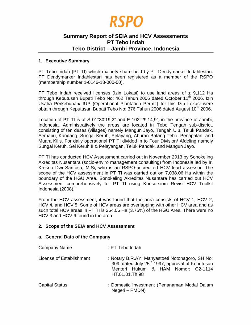
1. Executive Summary
PT Tebo Indah (PT TI) which majority share held by PT Dendymarker Indahlestari.PT Dendymarker Indahlestari has been registered as a member of the RSPO(membership number 1-0146-13-000-00).
PT Tebo Indah received licenses (Izin Lokasi) to use land areas of ± 9,112 Hathrough Keputusan Bupati Tebo No: 462 Tahun 2006 dated October 11th 2006. IzinUsaha Perkebunan/ IUP (Operational Plantation Permit) for this Izin Lokasi wereobtain through Keputusan Bupati Tebo No: 376 Tahun 2006 dated August 10th 2006.
Location of PT TI is at S 01°30’19,2” and E 102°29’14,9”, in the province of Jambi,Indonesia. Administratively the areas are located in Tebo Tengah sub-district,consisting of ten desas (villages) namely Mangun Jayo, Tengah Ulu, Teluk Pandak,Semabu, Kandang, Sungai Keruh, Pelayang, Aburan Batang Tebo, Penapalan, andMuara Kilis. For daily operational PT TI divided in to Four Division/ Afdeling namelySungai Keruh, Sei Keruh II & Pelayangan, Teluk Pandak, and Mangun Jayo.
PT TI has conducted HCV Assessment carried out in November 2013 by SonokelingAkreditas Nusantara (socio-enviro management consulting) from Indonesia led by Ir.Kresno Dwi Santosa, M.Si, who is an RSPO-accredited HCV lead assessor. Thescope of the HCV assessment in PT TI was carried out on 7,038.06 Ha within theboundary of the HGU Area. Sonokeling Akreditas Nusantara has carried out HCVAssessment comprehensively for PT TI using Konsorsium Revisi HCV ToolkitIndonesia (2008).
From the HCV assessment, it was found that the area consists of HCV 1, HCV 2,HCV 4, and HCV 5. Some of HCV areas are overlapping with other HCV area and assuch total HCV areas in PT TI is 264.06 Ha (3.75%) of the HGU Area. There were noHCV 3 and HCV 6 found in the area.
2. Scope of the SEIA and HCV Assessment
a. General Data of the Company
Company Name : PT Tebo Indah
License of Establishment : Notary B.R.AY. Mahyastoeti Notonagoro, SH No:309, dated July 25th 1997, approval of KeputusanMenteri Hukum & HAM Nomor: C2-1114HT.01.01.Th.98
Capital Status : Domestic Investment (Penanaman Modal DalamNegeri – PMDN)
Summary Report of SEIA and HCV AssessmentsPT Tebo Indah
Tebo District – Jambi Province, Indonesia
1. Executive Summary
PT Tebo Indah (PT TI) which majority share held by PT Dendymarker Indahlestari.PT Dendymarker Indahlestari has been registered as a member of the RSPO(membership number 1-0146-13-000-00).
PT Tebo Indah received licenses (Izin Lokasi) to use land areas of ± 9,112 Hathrough Keputusan Bupati Tebo No: 462 Tahun 2006 dated October 11th 2006. IzinUsaha Perkebunan/ IUP (Operational Plantation Permit) for this Izin Lokasi wereobtain through Keputusan Bupati Tebo No: 376 Tahun 2006 dated August 10th 2006.
Location of PT TI is at S 01°30’19,2” and E 102°29’14,9”, in the province of Jambi,Indonesia. Administratively the areas are located in Tebo Tengah sub-district,consisting of ten desas (villages) namely Mangun Jayo, Tengah Ulu, Teluk Pandak,Semabu, Kandang, Sungai Keruh, Pelayang, Aburan Batang Tebo, Penapalan, andMuara Kilis. For daily operational PT TI divided in to Four Division/ Afdeling namelySungai Keruh, Sei Keruh II & Pelayangan, Teluk Pandak, and Mangun Jayo.
PT TI has conducted HCV Assessment carried out in November 2013 by SonokelingAkreditas Nusantara (socio-enviro management consulting) from Indonesia led by Ir.Kresno Dwi Santosa, M.Si, who is an RSPO-accredited HCV lead assessor. Thescope of the HCV assessment in PT TI was carried out on 7,038.06 Ha within theboundary of the HGU Area. Sonokeling Akreditas Nusantara has carried out HCVAssessment comprehensively for PT TI using Konsorsium Revisi HCV ToolkitIndonesia (2008).
From the HCV assessment, it was found that the area consists of HCV 1, HCV 2,HCV 4, and HCV 5. Some of HCV areas are overlapping with other HCV area and assuch total HCV areas in PT TI is 264.06 Ha (3.75%) of the HGU Area. There were noHCV 3 and HCV 6 found in the area.
2. Scope of the SEIA and HCV Assessment
a. General Data of the Company
Company Name : PT Tebo Indah
License of Establishment : Notary B.R.AY. Mahyastoeti Notonagoro, SH No:309, dated July 25th 1997, approval of KeputusanMenteri Hukum & HAM Nomor: C2-1114HT.01.01.Th.98
Capital Status : Domestic Investment (Penanaman Modal DalamNegeri – PMDN)

Tax Payer Notification Number : 02.042.110.3-402.000
Company Address : Head Office:Karawaci Office Park, Ruko Pinangsia Blok L No.38-39, Lippo Karawaci, Tangerang, Banten,IndonesiaSite:Teluk Pandak Desa (village) Tebo Tengah sub-district Tebo District Jambi Province
Type of Business : Oil Palm Plantation
Status of Concession Land and :Permit
No. Kind of Permit/Recommendation Approved by No. and Date Ha
1 Approval forCultivationBusinessPrinciples in PalmOil Plantation
No: HK.350/E5.1256/12.9715 December 1997
10.500 Ha60 Ton FFB/Hours
2 Location Permit Head of LandRegistry Officeof Bungo TeboRegency
No: SK.32/ PIL/ 460/ PBT/ 199726 December 1997
15.000 Ha
3 LC Permit Head of LevelII Region ofBungo Tebo
No: 525/3215/Perek21 September 1998
a 4.500 Hafor tapah I
4 Location PermitExtension
Head of LandRegistry Officeof Bungo TeboRegency
No: SK.32-1/ PIL-P/ 460/ PBT/19998 March 1999
15.000 Ha
5 RecommendationPermit for LandDevelopment ofPalm OilPlantation
Tebo Regent No: 525/ 1141/ Ekonomi6 July 2000
An area of ±15.000
6 Recommendation/technicalconsideration forplantation landavailability for PTTebo Indah
Ministry ofForestry andEstate,Regional Officeof JambiProvince
No: 1591/ Kwl-Iic/ 200027 July 2000
The locationstatus of thearearequested inaccordancewithRTRWP-TGHKincluding theAPL farmingand non-

farmingcultivationarea, is notfrom theforest area
7 PlantationBusiness Permit
Minister ofAgriculture
No:640/Kpts/HK.350/Dj.Bun/VIII/2001
12.000 Ha60 Ton FFB/Hours
8 PlantationBusiness PermitExtension
Tebo Regent No: 376 Tahun 200610 August 2006
8.000 Ha
9 Allotment ofLocation Permit
Tebo Regent No: 462 Tahun 200611 October 2006
9.112 Ha
10 Committee BTreatise
The people’s land gained from land clearing is thensubmitted to KUD Tujuan Murni, and together asmembers of KUD Tujuan Murni they submit the landto PT Tebo Indah (Deed of Transfer of Land RightsNo. 1 dated 8 March 2006)The stated land will be managed by PT Tebo Indahby sharing 75% to PT Tebo Indah and 25% to KUDmembers (Cooperation Agreement No. 2 dated 8March 2006 in connection to Deed of the Minutes ofMeeting No. 1 dated 6 July 2005)
BPNregionaloffice ofJambiProvincestates thatthe landbeingconsideredto beapproved is7,038.06 Ha
11 Ownership of HGUPT Tebo Indah
Head ofNational LandAuthority
No: 27-HGU-BPN-RI-20094 February 2009
7,038.06 Ha
Contact Person : Mr. Donald Simanjuntak (Operational Director PTTI)
Geographical Location : S 01°30’19,2” and E 102°29’14,9”
Surrounding Entities :North : Tebo River and Batang Hari RiverSouth : PT SKU (Sinarmas)West : Aburan Desa (village)East : Penapalan Desa (village)
The scope of Social and Environment Impact Assessment of PT Tebo Indah coverthe HGU Area and the villages surrounding the project.
b. Legal Documents
The permits that have been obtained by the company as mentioned above.
c. Location Maps

Picture 1. Location of PT Tebo Indah in Indonesia
Picture 2. Location of PT Tebo Indah in Jambi Province
Picture 1. Location of PT Tebo Indah in Indonesia
Picture 2. Location of PT Tebo Indah in Jambi Province
Picture 1. Location of PT Tebo Indah in Indonesia
Picture 2. Location of PT Tebo Indah in Jambi Province

Picture 3. HGU Area of PT Tebo Indah in Tebo DistrictPicture 3. HGU Area of PT Tebo Indah in Tebo DistrictPicture 3. HGU Area of PT Tebo Indah in Tebo District

Picture 4. Overlay Map and Status of Forest Plantation PT Tebo IndahPicture 4. Overlay Map and Status of Forest Plantation PT Tebo IndahPicture 4. Overlay Map and Status of Forest Plantation PT Tebo Indah

Picture 5. Overlay Planting Project of PT Tebo Indah with RTRWP Tebo District,Jambi Province, IndonesiaPicture 5. Overlay Planting Project of PT Tebo Indah with RTRWP Tebo District,Jambi Province, IndonesiaPicture 5. Overlay Planting Project of PT Tebo Indah with RTRWP Tebo District,Jambi Province, Indonesia

Picture 6. Overlay Planting Project of PT Tebo Indah with Moratorium Revision 5 (13November 2013), sesuai SK Menhut No. 6018/Menhut-VII/IPSDH/2013
d. Area and Time-plan for New Planting
PT Tebo Indah development plan has incorporated the findings from SEIA (AMDAL)by Pusat Penelitian Lingkungan Hidup (PPLH) Universitas Jambi and HCVAssessments and Social Impact Assessments by Sonokeling Akreditas Nusantaraas described above when implementing the operational plans. Management plansfor HCV areas and management plans for handling social impact have been drawnup.
The total area located in HGU of PT Tebo Indah is 7,038.06 Ha. The areas has beenplanted since 2008 is 3,380.50 Ha, proposed new planting areas is ± 2,875.50 Ha.The HCV management plan has been developed for these areas ± 264.06 Ha andthere is unplantable areas around ± 518.00 Ha. According the operationalmanagement of PT Tebo Indah land development will commence in year 2013.
3. Assessment Process and Procedure
a. Assessor and Their Credential
HCV Assessor and Their Credential

The HCV assessment in the HGU Area of PT Tebo Indah by the RSPO accreditedassessors. The HCV assessment conducted from 1st – 6th November 2013 in theHGU Area and villages surrounding area was carried by Sonokeling AkreditasNusantara, located at Komplek Sari Inten No. 44 RT 02 RW 09, Ciomas Rahayu,Ciomas sub-district, Bogor District, 16610, West Java. Key consultants fromSonokeling Akreditas Nusantara have been accredited and approved by RSPO. Theteam members are:
Ir. Kresno Dwi Santosa, M.Si (Head of Expert Team in Social Economy andCulture)
Approved RSPO HCV Assessor.
Accomplishing Master of Science in Natural Resource and EnvironmentalManagement, IPB, graduated in 1999.
In 2008 – now, working with Tropenbos International Indonesia Program as ForestManagement Specialist and HCVF Coordinator. In the period he has performedassessment and training programs of Areas of High Conservation Value in HPH, HTIand Plantation. He is active in the drafting of Revision in Assessment Guidance ofHigh Conservation Value Areas in Indonesia (HCVF Toolkit Indonesia) and invarious meetings in the context of HCVF development in Indonesia. February 2003 –2007, he worked with CIFOR under the Directorate of Forest and Livelihood Programas Researcher and Project Officer in ITTO PD 39/00 Rev. 3 (F): “SustainableCollaborative Forest Management: Meeting the Challenges of Decentralization in theBulungan Model Forest”. In 2001 – 2003 he worked in BAPPENAS under theDirectorate of Natural Resource and Environment as Project Assistance in theproject of Integrated Biodiversity Strategy and Action Plan (IBSAP)-BSAP TF023957-IND, GEF World Bank, which is funded by the Global Environment Facility.
In 1996 – 2001 he worked on his Master’s degree and as a part time researcher inthe Study Center of Coastal and Marina Areas of the IPB Faculty of Fishery. HCVFHTI pre-assessment of PT Sumalindo Lestari Jaya, Batuputih Site, East Kalimantan.HCVF pre-assessment of PT Rea Kaltim Plantations, Kutai Kartanegara, EastKalimantan. HCVF HTI risk rapid assessment of PT RAPP Estate Tasik Belat,Meranti Bay, Kampar Peninsula. HCVF full assessment of landscape level inKampar Peninsula, a cooperation with TBI-APRIL-Research and Development Bodyof the Forestry. HCVF HTI full assessment of PT RAPP Estate Tasik Belat, MerantiBay, Kampar Peninsula. Reviewer of HCVF HTI risk rapid assessment of PT RAPPEstate Padang Island. Training instructor of HCVF technical assessment level, acooperation of TBI-WWF-TNC and INSTIPER.
Since December 2011 he has listed in RSPO as a specialist in Social Economy andCulture Discipline and as the Head of the Team.
Yanuar Wicaksono, Amd (Expert in Biodiversity)
Approved RSPO.

Graduated in 2003 from Diploma III Program of Forest Resource Conservation of theFaculty of Forestry, IPB.
Has worked as a lecturer’s assistance in subjects related with Wild Animals Ecologyand Ecotourism at the Department of Forest Resource Conservation and Ecotourism,Faculty of Forestry, IPB and at the Ecotourism Diploma Program, IPB. He has alsoworked as co-assistant in various student’s research for final examination in 2002 –2009.
In 2003 – 2006, he has been active in natural tourism activities, such as in CaritaNatural Tourism Park, Banten; Curug Nangka Forest Tourism, Bogor; CimangguNatural Tourism Park and several forest tourisms in South Bandung, a cooperationof Diploma III Program in Forest Resource Conservation and Ecotourism and Unit IIIJabar-Banten of the General Company of Perhutani.
Since 2010 – now, he has been active in assessment activities of High ConservationValue both in forestry (HPH/HTI) and palm oil plantation. Other than being involved inthe HCV assessment team, he has also been active in HCV trainings, both asexecutor and as manager.
Since December 2011 he has been listed in RSPO as specialist in Biodiversitydiscipline.
Ir. Agung Wibawa Anindita (Expert in Social Economy and Culture)
Bachelor of Forestry, majoring in Forest Management – Bogor Institute of Agriculture(IPB), graduated in January 1994.
Having 15 years of work experience, such as in fields connected with NaturalResource Management (especially in Forestry, Agriculture and Mining), EnvironmentManagement (environmental impact analysis, UKL and UPL, RKL and RPLimplementations, study baseline) and in SOCIAL, ECONOMY AND CULTURE.
Catur Wiradityo, S.Hut (Expert in Environmental Services)
Bachelor program in the Department of Forest Resource Conservation andEcotourism of the Faculty of Forestry in the Bogor Institute of Agriculture.
1. HCVA Assessment of PT Arrtu Borneo Perkebunan (Green Eagle Group) PalmOil Plantation of Ketapang Regency, West Kalimantan. PT SonokelingAkreditas Nusantara.
2. HCVA Assessment of PT Arrtu Energie Resources (Green Eagle Group) Palm OilPlantation of Ketapang Regency, West Kalimantan. PT Sonokeling AkreditasNusantara.
3. HCVA Assessment of PT Arrtu Agro Nusantara (Green Eagle Group) Palm OilPlantation of Ketapang Regency, West Kalimantan. PT Sonokeling AkreditasNusantara.

Farhan Nahdia, S.Hut (Assistant in Biodiversity)
Rahmat, Amd (Assistant to GIS and Mapping Expert)
Diploma III in Forestry of the Department of Silviculture, the Bogor Institute ofAgriculture.
Has been actively involved in various HCV studies as member of expert team in GISand mapping, such as in HCV activities and management in palm oil plantationareas, palm oil forests, Industrial Forests (HTI), Natural Forests (HPH) and mining.
The HCVA/F activities performed are:1. Industrial Forests (HTI) and Natural Forests (HPH) companies, namely: PT
Korintiga Hutani – Korinda Group (Central Kalimantan), PT Arara Abadi (Riau),PT Satria Perkasa Agung (Riau), PT Riau Abadi Lestari (Riau), PT SPASerapung (Riau), PT KTH Sinar Merawang (Riau), PT Wirakarya Sakti (Jambi),PT Finnantara Intiga (Central Kalimantan), PT Rimba Hutani Mas (Jambi), PTTebo Multi Agro (Jambi), PT Salaki Summa Sejahtera (West Sumatera).
2. Palm Oil Plantation Companies, namely: PT Guntung Idaman Nusa (Riau), PTAgro Palindo Sakti (South Sumatera), PT Agro Muara Rupit (South Sumatera).
3. Coal Mining Company, namely: PT Daya Bumindo Kurnia (Central Kalimantan).
Identification result of HCV PT TI involved public consulting process at 7 November2013 and Peer Review by a party other than Assessor i.e. Dr. Harnios Arief(approved RSPO HCV Assessor).
SEIA Assessor and Their Credential
The Social Impact Assessment of PT DMIL was carried out on by Pusat PenelitianLingkungan Hidup Universitas Jambi. The key consultants conducting theseassessments have been accredited and approved by RSPO. The team membersare:
Ir. Yanuar Fitri, M.Si
Accomplishing master’s degree in Regional and Rural Development in UNAND.Previously accomplishing the bachelor’s degree in Agriculture Development inUNJA.
Having AMDAL (environmental impact analysis) A and B.
Ir. Ermadani, M.Sc
Accomplishing master’s degree in Soil sciences in Australia. Previouslyaccomplishing the bachelor’s degree in the same science in UNPAD.
Having basic AMDAL training certificates.
Mursalin, S.TP, M.Si

Accomplishing master’s degree in Food Technology in IPB. Previouslyaccomplishing the bachelor’s degree in Agriculture Products Technology in UNILA.
Drs. M. Naswir, M.Si
Accomplishing master’s degree in Analytical Chemistry in UNPAD. Previouslyaccomplishing bachelor’s degree in Chemistry Education in UNJA.
Having basic AMDAL training certificates.
Ir. Neliyati, M.Si
Accomplishing master’s degree in Agronomy in IPB. Previously accomplishingbachelor’s degree in the same science in UNJA.
Having AMDAL A competence.
Dr. Ir. Lizawati, M.Si
Accomplishing doctoral degree in Biotechnology in IPB. Previously accomplishingmagister’s and bachelor’s degrees in Agronomy in IPB and UNJA.
Ir. Nahri Idris, M.Sc
Accomplishing master’s degree in Natural Resource Management in IPB. Previouslyaccomplishing bachelor’s degree in Husbandry Social and Economy in UNJA.
Having AMDAL A competence.
Chodidjah Alie, S.Pd, M.Kes
Accomplishing master’s degree in Community Health Science. Previouslyaccomplishing bachelor’s degree in Counseling Assistance.
Ir. M. Zuhdi, M.Sc
Accomplishing master’s degree in GIS in the Netherlands. Previously accomplishingbachelor’s degree in Soil sciences in UNJA.
Having basic AMDAL training certificates.
The AMDAL documents have been approved based on the Decree of JambiGovernor No. 362/Kep.Gub/BLHD/2009 dated 8 September 2009.
b. Assessment Methodology
HCV Assessment Methodology

Generally, the identification and analysis activities of NKT 1 – NKT 6 in PT Tebo Indahpalm oil plantation area, with activity stages as is described in Picture 7 and Picture 8.
Picture 7. Identification Process of High Conservation Value of PT Tebo Indah PalmOil Plantation Area
No NKT
Generally, the identification and analysis activities of NKT 1 – NKT 6 in PT Tebo Indahpalm oil plantation area, with activity stages as is described in Picture 7 and Picture 8.
Picture 7. Identification Process of High Conservation Value of PT Tebo Indah PalmOil Plantation Area
No NKT
Generally, the identification and analysis activities of NKT 1 – NKT 6 in PT Tebo Indahpalm oil plantation area, with activity stages as is described in Picture 7 and Picture 8.
Picture 7. Identification Process of High Conservation Value of PT Tebo Indah PalmOil Plantation Area
No NKT

Picture 8. Spatial Analysis Process of Related Maps to Support Early Analysis of High Conservation Value Potentiality
COLLECTING AND ANALYSIS OF SECONDARY DATA NKT AREAL
CLIMATE/RAINFALL MAP
LAND SYSTEMMAP
TOPOGRAPHYMAP
LANDCOVERAGE MAP
BIODIVERSITYMAP
HYDROLOGYMAP
SOCIAL ECONOMYCULTURAL MAP
RTRWP/KTGHK MAP
OVERLAY TBE MAP ANDLAND CAPABILITY
OVERLAY
OVERLAY
OVERLAY
ECOSYSTEM ANDREGIONAL
LANDSCAPE TYPES
DISTRIBUTION OFBIODIVERSITY MAP
PROTECTION ANDCONSERVATION
MAP
ENVIRONMENTSERVICES ANDBASIC NEEDS
STRATIFICATION MAP
COLLECTING OFFIELD DATA
CLIMATE, SOILAND
TOPOGRAPHY
REGIONALCOVERING/LANDSCAPE
FOREST/ECOSYSTEM
TYPES
FLORA ANDFAUNA
RIVER, SOCIALECONOMYCULTURE
ANALYSIS RESULT
TBE MAP ANDSOIL CAPABILITY
NKT 4
LANDSCAPEREGIONAL MAP NKT 2
MAP OF NEAREXTINCT
ECOSYSTEMNKT 3
BIODIVERSITYSPREAD MAP
NKT 1
BIODIVERSITY MAPIN PROTECTED AND
CONSERVATIONAREA
NKT 1
ENVIRONMENTSERVICE AND BASIC
NEEDS MAP
NKT 4NKT 5
CULTURE IDENTITYMAP
NKT 6
MAPPING ANALYSIS ANDDATA COMPILATION
DECISIONMAKING
KBKT MAP AND REPORT

SEIA Assessment Methodology
The method is performed in the collection and analyses of data for PT Tebo Indahare:a. Identify the potential impact that comes from a description of the activity plan
proponent and the condition of the environment hue. The result of theidentification of potential impacts is the potential impact.
b. Evaluation of all potential impacts that generated hypothetical significant impactsby eliminating potentially significant impact.
c. Classification and priority hypothetical significant impacts with the intention thatthe scope and depth AMDAL studies that produce significant impactshypothetical priority.
4. Summary of Findings
a. Summary of Assessment Findings for HCV Assessment
From the HCV assessment, it was found that the area consists of HCV 1, HCV 2,HCV 4, and HCV 5. Some of HCV areas are overlapping with other HCV area and assuch total HCV areas in PT TI is 264.06 Ha (3.75%) of the HGU Area. There were noHCV 3 and HCV 6 found in the area.
Table 1. High Conservation Area in PT TI Palm Oil Plantation
No. Location HCVA Attributes HCVA Area (Ha)1 Bungkal River 1.1, 1.3, 1.4, 2.3, 4.1 34.452 Rengas River 4.1 18.813 Belilas River 1.1, 1.3, 1.4, 2.3, 4.1 59.604 Kait River 1.1, 1.3, 1.4, 2.3, 4.1 41.815 Keruh River 1.1, 1.3, 1.4, 2.3, 4.1 21.006 Air Hitam River 4.1 8.957 Penapalan River 1.1, 1.3, 1.4, 2.3, 4.1 39.438 Penyabungan River 4.1 19.359 Tebo River 4.1 3.3610 Forested area 1.1, 1.3, 1.4, 2.3 5.5411 Lake Cape Disconnect 1.1, 1.3, 1.4, 2.3, 4.1, 5 11.3612 Breeding ponds 4.1 0.3113 Ponds 4.1 0.11
Total 264.06


Picture 9. Identification HCV Area and Plan Project Area of PT Tebo IndahPicture 9. Identification HCV Area and Plan Project Area of PT Tebo IndahPicture 9. Identification HCV Area and Plan Project Area of PT Tebo Indah

Picture 10. Overlay HCV Area and Planting Project in HGU Area of PT Tebo IndahPicture 10. Overlay HCV Area and Planting Project in HGU Area of PT Tebo IndahPicture 10. Overlay HCV Area and Planting Project in HGU Area of PT Tebo Indah

Table 2. Summary of Management and Monitoring Recommendation
HCVA Threat Management Recommendation Monitoring Recommendation
HCVAGENERAL(river / lake /water basinalong theborder andforested area)
1) Forest fire danger whenconsidering the droughtconditions in part shrubareas. Generally, land andforest fires that occurredwere intentionalperformedwhen clearing land forcultivation.
2) Occupational status of theprotected area because thisarea there are some partsthat are owned by thecommunity and the UP hasnot released him.
3) Illegal logging in the area hasbeen designated as aprotected area.
4) a potential threat in the futureis at the opening of the land(landclearing), the contractorusually ignoring the limits ofareas defined as HCVA.
5) Surrounding communities
1) Establishment of protected areas.
2) Dissemination of High ConservationValue Areas (HCVA) and protectedareas to all parties, including thepublic, local government andmanagement unit.
3) Structuring and participatory boundarymeasurements.
4) Pile limits, either in the form ofboundary markers and poletan in thestem of the plant.
5) Installation of information boards andsigns Area High Conservation Value(HCVA), and protected areas,especially in the area around the town/ village and roads traversed by thepublic and staff management unit.
6) Maintenance of boundary markers,signs, information boards and treetrunks poletan on a regular basis.
7) Security area of activity
1) Level Measurementeffectiveness of socialization /education environmentindicated the level ofcommunity participation inhelping to secure the areaand / or actively maintainprotected areas.
2) Measurement of the extent ofdamage / disturbance ofprotected areas as a result ofthe activity of UP and otheractivities.
3) Measurement of levels ofplant diversity in protectedareas.
4) Measurement of the level ofdiversity of wildlife inprotected areas.
5) Monitoring the intensity ofdisturbance (encroachment,logging, fire).

and workers (employees) donot understand fully theimportance of HighConservation Value / HCVfor sustainable farmmanagement andenvironmental sustainability.
6) The possibility of differencesin interpretation of theboundary area identified asHCV, if there are no clearboundaries. It iscan lead toland clearing in areas thathave HCV, becausecontractors are often moreoriented to the target size ofthe volume of work.
encroachment, logging and poaching itand as fire control implementation canbe integrated with other securityactivities. Then for the existence of theprotected area can be preserved andmaintained in the long term inaccordance with the expected goalssocialization and counseling /education environment should bedone regularlyAnd the implementation cancoordinate with relevant agencies.
8) To increase the biodiversity in HCVAnecessary enrichment. The types ofplants are best are the types of nativeplants, endangered / protected, andthe seed easily obtainable from thesurrounding area.
9) Establish connectivity betweenpockets of animals, especially thatcontained in the connecting areabetween the UP corridor (in this caseriparian potential as a natural corridor),and then connectwith large corridors, namelyBatang Hari river border.
10)At the time of the opening of the land(land clearing) by the contractor is
6) Monitoring rehabilitationsuccess rate.

expected to be disseminated about theexistence HCVA, so that the openingis no longer haphazard.
HCVA SPECIAL(river / lake /water basin andriver border
1) Making water tank which is moreadequate to prevent the entry ofchemical residues.
2) Do not do the cleaning cover crop(cover crops) for the blocks in thearea of water protection.
3) Do not use chemicals containingchemicals B3 around bodies of water.
1) Discharge and water qualitymonitoring on a regular basiswith a certain period.
2) Monitoring sedimentation rate.


b. Summary of SEIA Findings
Large and Necessary Effects (Positive)
The structuring and coaching activities of the conservation areas and theconstruction of terrace and planting of covering plants will protect the soil ofdamages due to erosion that the land quality/fertility will be maintained and therewill no soil particles flown into the river. Therefore the river will be avoided fromturbidity process.
Fertilization activities and raising of appropriate soil covering plants can improvesoil fertility/quality.
Changes of work opportunity and business, household earnings, cooperationorganization, accessibility and people’s mobility.
Procurement of work force creates work opportunities.
Large and Necessary Impacts (Negative)
Land clearing and preparation will cause the lost of land covering vegetationwhich causes land erosion because of rain water particles and surface flow.
The quality of surface water will decline due to agrochemical residue used inraising activities including pest and disease control and also weeds. The overuseof fertilizer will also cause the decline in water quality.
Changes in the process (social conflice), behavior and people’s perception. If plantation business does not operate there will be dissolution in partnership and
work relationship.

Source of Impact Purpose of Management Method of ManagementGeophysican-ChemicalComponent
Air quality1) Transportation and
Production Meansand Fresh FruitBunch
Surface water quality1) Clearing and
preparation of landsfor plantation,nurturing of non-yielding plants (TBM)and yielding plants(TM).
1) Reducing air pollution level so as not toexceed the quality standard.
2) Reducing the surface water pollution levelso as not to exceed the threshold ofsurface water quality standard Class II.
Construction until operation stage (technologicalapproach)1) The vessel used for transportation must already
pass emission test.2) The vessel must travel down the road at limited
speed.3) The roads travelled by the vessel in summer must
be sprinkled with water.4) Consider layering asphalt on the main road of
plantation.
Construction to operation stage (technologicalapproach)1) Land clearing must be performed gradually in
accordance with the condition and distribution ofland area.
2) Planting of legume cover crop (LCC) immediatelyafter the land is cleared.
3) Usage of fertilizer in accordance with therecommendation, which includes dosage,frequency and method of fertilizing.
4) Minimizing the usage of agrochemical ingredientsto control pets and disease by applying theintegrated and natural pest control system.
5) Maintaining and creating green belt around theriver banks and other conservation areas.

Quality of ground water1) Clearing and
preparation of landfor landscaping,management of TBMand TM.
Land Erosion1) Land clearing and
preparation forplantation.
Land fertility / quality1) Land clearing and
preparation forplantation.
3) Reducing the level of ground waterpollution in order to not exceed thethreshold for ground water (well water)quality standard.
4) Attempting to accelerate land erosionwithout exceeding the allowed erosionrate.
5) Mitigating the reduction of soil quality.
Construction to operation (technological approach)1) Land clearing is performed gradually in
accordance with the respective land area andinclination.
2) Coverage of cleared land with legume cover crop.3) Balanced usage of organic and chemical fertilizer.4) Implementation of integrated pest and disease and
parasite control system by minimizing the usage ofchemicals.
Construction to operation (technological approach)1) Land clearing is performed gradually in
accordance with the respective land area andinclination.
2) Coverage of cleared land with legume cover crop.3) Creation of green belt around the river bank and
other conservation area.4) Creation of terrace on land with 20-25% of
inclination.
Construction to operation (technological approach)1) Land clearing is performed gradually in
accordance with the respective land area andinclination.
2) Coverage of cleared land with legume cover crop.3) Creation of green belt around the river bank and
other conservation area.4) Balanced usage of organic and chemical fertilizers
in accordance with the recommended method anddosage.
5) Creation of terrace on land with 20-25% inclination.

Biological Components
Changes in ecosystem1) Negative impact: land
preparation andclearing.
2) Positive impact:management andlayouting ofconservation area.
Changes in vegetationcomponent1) Negative impacts:
from land clearingand preparationactivities, which resultin reduction / loss ofvegetationcomponent.
1) Protecting and managing the remainingnatural ecosystem and safeguarding theconservation area in the activity zone aswell as converting the area into a sourceof biodiversity.
2) Maintaining the balance of natural plantbiodiversity.
3) Minimizing disturbance, damage andreduction in protected vegetation species.
Construction stage (technological approach)1) Gradual land clearing, burning restriction,
restriction from clearing land in a river bank area,production forest area inside the authorizationzone.
2) Soil coverage is performed on cleared lands.3) Verification of conservation area by stipulating
legal boundaries, conservation of river banks,inclination > 25%.
4) Involving the surrounding population by creatinglocal forest.
5) Construction of security posts, periodical patroland procurement of emergency response facilities/ infrastructure.
Construction to operation stage (social approach)1) Development of cooperation with universities and
BKSDA in managing / layouting conservation area.
Construction stage (technological approach)1) Not clearing lands in conservation area.2) Verifying zone by stipulating legal conservation
area boundaries.3) Refraining from cutting down protected trees.4) Planting or enriching the river bank area.5) Replanting aroundd houses, offices and other
infrastructures.6) Labeling protected trees.

2) Positive impact: frommanagement andlayouting ofconservation areabased on the existingregulations.
Changes in animalhabitat, biodiversity andprotected animals1) Land preparation and
clearing givesnegative impact
2) Layouting and
4) Minimizing the reduction of animal habitatquality, empowering the conservationarea to function as substitute habitat andmaintaining the biodiversity of wild fauna,especially those considered to be part ofthe biodiversity and deemed useful for theecosystem and science alike.
7) Creating no logging board in conservation areassuch as river banks, with inclination > 25%.
8) Research and development of protectedvegetation.
9) Placing a sign which restricts people from cuttingdown protected trees.
10)Protection and observation of the said areathrough periodical patrol.
Construction to operation stage (social approach)1) Socialization and briefing for the local population
and employees regarding the conservation of riverbank / stream, inclination > 25% and replanting oftrees around the company.
2) Socialization and procurement of skills for the localpopulation and company employees regarding theforest vegetation cultivation techniques.
Operational stage (Institutional approach)1) Development of cooperation with stakeholders
such as universities and research institutions in theattempt to study and develop forest vegetation,especially protected flora.
Construction Stage (Technological Approach)1) Gradual land clearing by refraining from burning
trees.2) Refraining from clearing lands within the
conservation area.3) Refraining from cutting down trees / remaining
vegetation which can serve as source of food /

management ofconservation area aswell as planting ofpalm coconut trees togive positive impact.
Changes in pests,diseases, parasites andnatural predators’population
5) Optimizing pest, disease and parasitecontrol through preventive methods.
6) Safeguarding natural balance / existenceof natural predators.
nesting grounds for certain animal species.4) Verifying conservation area by stipulating legal
conservation area boundaries.5) Planting and enriching river bank area through the
involvement of local population.6) Replanting of vegetation around houses, offices
and other infrastructures.7) Placing a sign which restricts people from
poaching protected animal species.8) Replacing a list of the types of wildlife.9) Constructing security posts and assigning patrols.
Construction stage (social approach)1) Socialization and briefing to local population
regarding protected animal species and poachingrestrictions.
2) Involving field technicians in trainings / seminarsrelated with animal conservation.
Construction to Operational Stage (Institutionalapproach)1) Law enforcement on restrictions regarding
restrictions on cutting down trees in conservationarea.
2) Law enforcement on poaching of protectedanimals within the plantation area.
Construction to operation stage (technologicalapproach)1) Gradually clearing the area without burning trees.2) Planting palm coconut trees using certified trees.

1) Land clearing andpreparation,procurement of seedsand seeding, plantingof palm coconut treeswith monoculturalsystem.
2) Maintenance of palmcoconut trees,especially pest anddisease eliminationusing excessivepesticides over aprolonged period oftime.
3) Integrated plant management using mechanicaland biological control methods.
4) Research and development of various PHTtechnology.
5) Minimizing the use of chemical materials.6) Forming a monitoring team to monitor pest and
disease as well as competent natural predators.7) Routine / scheduled monitoring of pest, disease
and natural predators.8) Creating a list of natural predators, their images
and host plants.9) Placing a sign which restricts people from
damaging the host plants and natural predators.10)Research and development on natural predator
species.
Construction to operation stage (social approach)1) Briefing and training to local farmers and
employees regarding integrated plantmanagement.
2) Socialization on types of pest and diseasesinvading palm coconut trees and natural predatorsas well as host plants.
3) PHT technology aid package for plasma farmers.
Construction to operational stage (institutionalapproach)1) Cooperating with universities in conducting
research and briefing on plant management in anintegrated manner and development of host plantsand natural predators for pests and plant diseases.

Water organism1) Negative impact: land
clearing andpreparation and plantmaintenance.
2) Positive impact:Management ofconservation areaand soil coverage.
7) Protecting water organism biodiversity toconserve the water ecosystem.
Construction to operational stage (construction ofintegrated pest control unit at PT Tebo Indah)
Construction to operation stage (technologicalapproach)1) Land clearing and preparation is performed
gradually, without fuel and immediately followed bysoil coverage legumes.
2) Refraining from clearing and preparing land in theriver bank area.
3) Letting natural plants grow at river banks.4) Conducting integrated plant management which
prioritizes pest, disease and parasite controlwithout using chemicals.
5) Placing signs which restrict people from fishing inthe river using toxic methods.
6) Monitoring river water organisms.
Construction to operational stage (social approach)1) Briefing for the local population, employees and
plasma farmers regarding the importance of waterorganisms and river bank conservation.
2) Briefing and training for plasma farmers andplantation employees regarding integrated plantmanagement.
3) Conducting briefings and trainings on fisherybusiness.
Operational stage (Institutional approach)1) Construction of integrated pest control unit at PT

Tebo Indah.2) Conducting research with universities and
educational institutions on environmentalmanagement, specifically on pests, diseases andparasites.
Socioeconomic andcultural component
Demographic changes1) Procurement of work
force.
Changes in work andbusiness opportunities1) Procurement of
1) In order for the demographic changes tooccur reasonably and to not disturb thedaily lives of local population as well asminimize potential conflicts due toemployee migrants.
2) To give work opportunities to localpoulation, reduce unemployment, createproduction economy business
Preconstruction to construction stage (technologicalapproach)1) Socializing plantation activities to the local
population, especially regarding the recruitment ofemployees and the possibility of non-localemployees staying in the area.
Preconstruction to operational stage (Social approach)1) Encouraging and briefing non-local employees on
ways to adapt with the local situation and condition.2) Holding activities which encourage employees and
local population to familiarize with each other.
Preconstruction to operation stage (institutionalapproach)1) Giving routine and detailed reports to village
apparatus and authorities regarding the arrival ofemployees in the area.
Preconstruction to operation stage (technologicalapproach)1) Giving priority to local work force in accordance

worker, land clearingand soil coveragelegume, maintenanceof TBM andmaintenance of TM.
Changes in householdincome1) Procurement of work
force, land clearingand soil coverage,maintenance of TBM,TM and harvesting.
opportunities.
3) To increase public income frompioneering activities.
with the required education and skill set with a ratioof 70: 30 (local: non-local). Meanwhile, skilledemployees should prioritize local work force inaccordance with the required knowledge.
2) Conducting education programs and trainings forlocal work force.
3) Conducting public empowerment program inproductive economy to create work opportunities.
Preconstruction to operation stage (social approach)1) Socializing and briefing the local population
regarding the types of work, position, educationand skills required for the job.
2) Providing transparent/open information for the localpopulation when recruiting new employees inaccordance with the required skills and education,including transparency of selection.
Preconstruction to operational stage (institutionalapproach)1) Involving village authorities and the local
Employment Agency in recruiting and preparingwork force.
Preconstruction to operational stage (technologicalapproach)1) Priority local employment in accordance with the
education and skills possessed.
Preconstruction to operational stage (social approach)1) Education and training programs for local workers,

Changes in cooperativeinstitution1) Procurement of work
force, land clearingand soil coverage,maintenance of TBM,maintenance of TMand harvesting.
4) In order to further empower thecooperative for the purpose of improvingthe economy and welfare of its members.
especially in the attempt to empower local people.
Preconstruction to operational stage (Institutionalapproach)1) Cooperating with public economic institution /
cooperatives and relevant institutions to developfamily potentials in order to increase householdincome.
Preconstruction stage (technological approach)1) Making use of the existing cooperative as the
company’s partner.2) Creating a new cooperative based on areal grid,
ex. In ever village.
Preconstruction to operational stage (technologicalapproach)1) Providing education programs and trainings for
cooperative officials and public figures.2) Assisting cooperative administration.
Preconstruction to operational stage (social approach)1) Socializing the imporance of a healthy cooperative
for the people’s economic activities to its members.
Preconstruction to operational stage (institutionalapproach)1) Involving the cooperative in plantation activities,
eg. in monitoring the maintenance of plants andharvesting.

Changes in publicmobility and access1) Creation of roads,
base camp anddrainages.
Social Changes (Socialconflict)1) Land acquisition,
procurement of workforce and resolutionof partnership andemployment dispute.
5) In order to increase public dynamics byimproving public access and mobility in apositive manner due to pioneeringactivities.
6) To minimize social conflicts which mayoccur due to pioneering activities as wellas to prevent public unrest.
Preconstruction to operational stage (technologicalapproach)1) Assisting village road maintenance.
Preconstruction to operational stage (social approach)1) Creating sidewalks for pioneering and public
needs.
Pre-construction to operational stage (Institutionalapproach)1) Cooperating with relevant institutions in
maintaining and repairing roads.
Preconstruction stage (technological approach)1) Land clearing in a wise, voluntary and legal
manner by the public, free of duress or peerpressure.
2) Creating an ideal, transparent partnership system.
Preconstruction to operational stage (technologicalapproach)1) Handling and treatment of work force in
accordance with the existing provisions of law.2) Local work force priority in every stage of activity.
Preconstruction to operational stage (Social approach)1) Socializing every stage of activity to the public.2) Harmonizing the people around the plantation and
the employees.
Preconstruction to operational stage (institutional

approach)1) Routine meeting between the Company and
government authorities on every level as well asthe public figures for the purpose of goodcommunication and relationship.
2) Involving the village authorities, public figures andrelevant institutions in community-wide decisionmaking.
Operational stage (technological approach)1) Harvesting and dividing yields in a transparent
manner.
Operational stage (institutional approach)1) Involving the public, in this case the cooperative,
as supervisors during the harvest.
Post-operational stage (technological approach)1) Termination of partnership and employment in
accordance with the applicable provisions of law.
Change of public attitudeand perception1) Socialization,
methods of acquiringlands, procurementof employees,harvesting,management ofconservation area,CSR, resolution of
7) In order to bolster good perceptionamong the public towards the pioneeringactivities as well as prevent public unrest.
Preconstruction stage (technological approach)1) Acquisition of lands in a wise manner through
consensus.
Preconstruction to operational stage (technologicalapproach)1) Prioritizing local workers in every stage of activity.2) Involving cooperatives in monitoring the
management of plantation and harvest.

employmentdisputes andpartnership disputes.
Preconstruction to operational stage (social approach)1) Socializing every stage of activity to the public.2) During public dispute, the people are given the
opportunity to resolve it on their own, facilitated byvillage authorities.
Preconstruction to operational stage (institutionalapproach)1) Holding activities for the employees and the public
to bolster harmony.2) Routine meeting between the Company and formal
/ non-formal government apparatus on every leveland the public figures to create goodcommunication and relationship.
3) Cooperating with public social institutions whenholding social activities.
Construction to operational stage (social approach)1) Creation of public facilities used by the local
population, eg. Roads, healthcare facilities, schoolsand social infrastructures.
Post-operational stage (technological approach)1) Resolution of partnership and employment issues
in a proper manner according to the applicableprovisions of law.
Changes in naturalresources economy1) Impact of reduced
economic value of
8) In order to prevent drastic decrease ofnatural resources’ economic value in thearea.
Pre-construction to post-operational stage(technological approach)1) Complying with all provisions and regulations
regarding plantation business and conservation of

natural resources isderived from the landclearing activities toconstructplantations, whereaspositive impact canbe gained fromlayouting andmanagement ofconservation area.
the environment.2) Conducting provisions on environmental
management and monitoring plans.3) Layouting and managing conservation areas in
accordance with the applicable regulations.
Public HealthcareComponent
Disease Pattern1) Mobilization of heavy
equipments, landpreparation,maintenance of TBMand TM.
Environmental Health1) Creation of roads,
base camp,drainages, landclearing andpreparation andmaintenance of TBMand TM.
1) Preventing work accidents and diseasesamong the employees and localpopulation.
2) Preventing increased density of surfacewater pollution level and vectors as wellas increasing work productivity withoutlosing work days due to decreased workenvironment quality.
Construction to operational stage (technologicalapproach)1) Implementing optimal work health and safety
management for the workers.2) Implementing general principles of safety.3) Attempting promotive and preventive actions.
Construction to operational stage (technologicalapproach)1) Monitoring ground surface passed by vehicles and
immediately patching potholes that can turn intopool during the rain.
2) Paying attention to the inner space and shape ofdrainage.
3) Monitoring fishbone duct around the plantation.4) Cleaning fishbone duct.5) Monitoring larvae density around the breeding site

or adult mosquitoe population around the location,especially during the rainy season.
6) Controlling vectors using larvae-eating fish as ameans of biological control.
7) Managing surface water quality.8) Implementing the HSE management in a hollistic
manner by taking into account the workers’ rightsregarding healthcare and safety.

5. Internal Responsibility
Formal Sign-off by Assessors and Company
This document is the Summary of SEIA (Social & Environmental ImpactAssessment) and HCV (High Conservation Value) Assessment of PT Tebo Indah.
(_____________________) (_____________________)Consultant of HCV Consultant of SEIA
Statement of Acceptance of Responsibility for Assessment
The Assessment Result of the Social & Environment Impact Assessment (SEIA) andHigh Conservation Value (HCV) Assessment of PT Tebo Indah by Pusat PenelitianLingkungan Hidup (PPLH) Universitas Jambi and Sonokeling Akreditas Nusantarawill be applied as part of the guidelines in developing and managing PT Tebo Indah.
Beni HendrawanChief Executive Officer