SUMMARY OF PROPOSED PLANNING CHANGES · proposed growth in housing and jobs. Sydney Olympic Park is...
44
Sydney Olympic Park SUMMARY OF PROPOSED PLANNING CHANGES Sydney Olympic Park Master Plan 2030 State Environmental Planning Policy (State Significant Precincts) 2005 AUGUST 2016
Transcript of SUMMARY OF PROPOSED PLANNING CHANGES · proposed growth in housing and jobs. Sydney Olympic Park is...

Sydney Olympic ParkSUMMARY OF PROPOSED PLANNING CHANGES
Sydney Olympic Park Master Plan 2030State Environmental Planning Policy (State Significant Precincts) 2005 AUGUST 2016

Sydney Olympic Park | Review of Planning Framework
Executive Summary 01
Context 04
Planning Framework 06
Master Plan 2016 Review 07
Community Consultation 08
Next Steps 09
Existing Transport Network 10
Strategic Centre 11
Site Constraints and Considerations 12
Future Desired Character 15
The Proposal 16
Built Form 17
Access and Transport 18
Open Space and Community Uses 19
Precincts 21
© Crown Copyright 2016
Disclaimer
While every reasonable effort has been made to ensure that this document is correct at the time of printing, the State of New South Wales, its agents and employees, disclaim any and all liability to any person in respect of anything or the consequences of anything done or omitted to be done in reliance or upon the whole or any part of this document.
Copyright Notice
In keeping with the NSW Government’s commitment to encourage the availability of information, you are welcome to reproduce the material that appears in this report for personal, in-house or non-commercial use without formal permission or charge. All other rights are reserved. If you wish to reproduce, alter, store or transmit material appearing in this document for any other purpose, requests for formal permission should be directed to: NSW Planning & Environment GPO Box 39 Sydney NSW 2001.
For more information visit: www.planning.nsw.gov.au/www.planning.nsw.gov.au/olympicpark
Central Precinct 23
Stadia Precinct 25
Parkview Precinct 27
Boundary Creek and Tennis Precincts 28
Central Sports Precinct 29
Southern Sports Precinct 30
Explanation of Intended Effect 31
Proposed Building Height Amendments 33
Proposed Floor Space Ratio Amendments 34
Proposed Reduced Level Amendments 35
Proposed Heritage Amendments 36
Infrastructure Analysis 37
Supporting Documents 39
Source of Images 40

Sydney Olympic Park | Review of Planning Framework 01
Executive Summary
Creating an active Town CentreSydney Olympic Park Authority’s vision is for the Sydney Olympic Park Town Centre to be an active and energised town centre with a range of facilities and services to support residents and workers in the peninsula, while creating a great experience for visitors to this world-class sports and major events destination.
To continue the work towards this vision, the review:
• encourages mixed use development along Australia Avenue, Olympic Boulevard, Dawn Fraser Avenue, Murray Rose Avenue, Sarah Durack Avenue and Edwin Flack Avenue
• creates opportunities for a varied day and night economy
• consolidates sites to create opportunities for a mix of retail and commercial uses and introduce additional residential dwellings in appropriate locations
• integrates educational uses with existing sporting facilities
• integrates civic and community uses with other uses
• amends venue expansion sites to provide complementary uses for visitors, while protecting the Olympic legacy
• improves walking and cycling connections and increases overall access through new streets, laneways, service streets and footpaths; intersection upgrades; separated crossings; and additional walking/cycling bridges
• creates a new central urban park and improves and expands other local parks.
These proposals are managed through changes to planning controls relating to building heights, setbacks and floor space ratios.
• create a number of tower building zones and increase maximum building heights to reinforce the Town Centre’s urban structure
• complement and enhance the distinct skyline by using building design and consistent setbacks to better define major north-south streets
• limit the proposed floor plate of tower buildings to maintain a skyline of slender buildings
• change building zones and setbacks to create a block edge town centre form and encourage active frontages
• increase floor space ratio controls on currently underdeveloped sites.
The review is supported by several regional and local infrastructure improvements:
• new streets and existing streets and intersection upgrades and crossings
• upgrades to bus and rail stations, shuttle bus services and bus stops/laybys, and travel demand management
• the proposed Light Rail service from Parramatta to Strathfield
• improvements to parks and recreation facilities
• a new high school site
• community facilities such as a library and community centre
• environmental infrastructure such a stormwater control and drainage and expansion of the waste water recycling system.
These proposals are provided for public comment, making direct public and industry feedback an essential element of the review process.
The Sydney Olympic Park Authority Act 2001 requires Sydney Olympic Park Authority to prepare and maintain a Master Plan for Sydney Olympic Park. The Authority developed its Master Plan 2030 in 2010.
Both the State Environmental Planning Policy (State Significant Precincts) 2005 and the Master Plan 2030 require Sydney Olympic Park Authority to review the Master Plan every five years.
This document summarises the findings of this review.
The review, undertaken by Sydney Olympic Park Authority in partnership with the Department of Planning and Environment, was informed by:
• A Plan for Growing Sydney, which identifies the Olympic Peninsula as a major new development area within the Greater Parramatta to Olympic Peninsula Priority Growth Area
• a desire to broaden the types of activity within Sydney Olympic Park, and respond to market interest for residential development in the precinct
• new priority precincts at Wentworth Point and Carter Street
• improved access from Hill Road off ramp and the proposed Light Rail service from Parramatta to Strathfield
• consultation with local councils, State agencies, key stakeholders and the local community.
The review focused on the Sydney Olympic Park ‘Town Centre’ – the 210 hectare area that includes the rail station, bound by Hill Road to the west, parkland to the north and east and the M4 Western Motorway and Homebush Bay Drive to the south.
Artist’s impression of Olympic Park 2030

Planning for the future…
Vibrant public spaces with more shops, places to eat and attractions during the day and in the evening
New shared paths and local roads connecting homes to transport, parks and events
More open space and neighbourhood parks for people to enjoy
02 Sydney Olympic Park | Review of Planning Framework
Olympic Boulevard
Linear park – Central Precinct
Local park – Parkview Precinct

More street life, centred around great events continuing the Olympic legacy
More housing close to jobs, services and transport
…the new Master Plan for Sydney Olympic Park
Sydney Olympic Park | Review of Planning Framework 03
Future assessments and planning simplified, using state-of-the-art 3D modelling for better planning and design outcomes
ANZ Stadium Australia Avenue
Future Central Precinct 3D view
04 Sydney Olympic Park | Review of Planning Framework
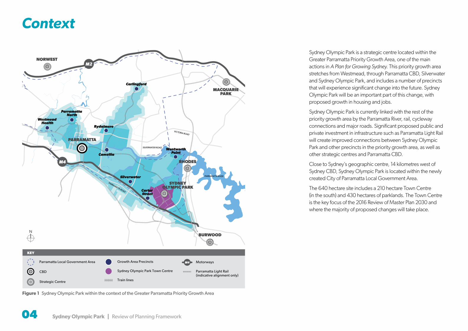
Context
Sydney Olympic Park is a strategic centre located within the Greater Parramatta Priority Growth Area, one of the main actions in A Plan for Growing Sydney. This priority growth area stretches from Westmead, through Parramatta CBD, Silverwater and Sydney Olympic Park, and includes a number of precincts that will experience significant change into the future. Sydney Olympic Park will be an important part of this change, with proposed growth in housing and jobs.
Sydney Olympic Park is currently linked with the rest of the priority growth area by the Parramatta River, rail, cycleway connections and major roads. Significant proposed public and private investment in infrastructure such as Parramatta Light Rail will create improved connections between Sydney Olympic Park and other precincts in the priority growth area, as well as other strategic centres and Parramatta CBD.
Close to Sydney’s geographic centre, 14 kilometres west of Sydney CBD, Sydney Olympic Park is located within the newly created City of Parramatta Local Government Area.
The 640 hectare site includes a 210 hectare Town Centre (in the south) and 430 hectares of parklands. The Town Centre is the key focus of the 2016 Review of Master Plan 2030 and where the majority of proposed changes will take place.
Figure 1 Sydney Olympic Park within the context of the Greater Parramatta Priority Growth Area
Strategic Centre
CBD
Growth Area Precincts
Sydney Olympic Park Town Centre
Train lines
Parramatta Light Rail (indicative alignment only)
KEY
MotorwaysParramatta Local Government Area MM4
NORWEST
MACQUARIEPARK
Westmead Health
Parramatta North
Rydalmere
Carlingford
Camellia
Silverwater
WentworthPoint
Carter Street
PARRAMATTA
SYDNEYOLYMPIC PARK
RHODES
BURWOOD
PARRAMATTA ROAD
VICTORIA ROAD
SILVERWATER ROAD
PARRAMATTA RIVER
M4
M2

Sydney Olympic Park | Review of Planning Framework 05
Context
Lidcombe
Carter Street Precinct
Rhodes
Parramatta River
Parklands
Olym
pic Boulevard
Parklands
M4 Motorway
Parramatta Road
Wentworth Point
Newington
Silverwater
Figure 2 Sydney Olympic Park and context in 2016
Sydney Olympic Park
Sydney Olympic Park Town Centre
Surrounding DevelopmentDevelopment around Sydney Olympic Park includes the following areas.
Carter Street
To the southwest of the Park, this area was rezoned in November 2015. It includes:
• more than 5,500 dwellings in buildings of 4-20 storeys
• employment uses along the M4 Motorway
• a mixed use village centre
• a primary school
• a multi-purpose community facility
• new parks including a 1.8 ha village park and a new foreshore reserve along Haslams Creek.
Wentworth Point
To the north of the Park, this suburb is currently being developed for medium and high rise residential apartments. The land at the end of the peninsula was rezoned in June 2014 as the Wentworth Point Priority Precinct and will provide:
• up to 2,300 dwellings
• maritime uses
• foreshore open space.
• the Bennelong Bridge, linking public transport to the Rhodes Peninsular
At its completion, the entire Wentworth Point peninsula could accommodate up to 9,500 dwellings. This also includes a new local centre on Sydney Olympic Park Authority land (at the ferry wharf).
Newington
To the west of the Park, across Haslams Creek, the former Athletes Village comprises medium density housing.
Homebush
To the south east of the Park, Homebush was considered as part of the draft New Parramatta Road Urban Transformation Strategy. This work identified a potential increase of up to 17,354 dwellings in the precinct by 2050, from the existing 1,721 dwellings.
Rhodes
The Rhodes East area that lies to the east of the Park was nominated as a potential Priority Precinct by the City of Canada Bay Council. It includes land on the Rhodes Peninsula, on the eastern side of the Northern Rail Line and within walking distance of Rhodes Train Station. The Department is working with council and Sydney University to investigate opportunities to revitalise Rhodes East.
Olym
pic Boulevard
Homebush
Olym
pic Boulevard

Bennelong Park way
06 Sydney Olympic Park | Review of Planning Framework
Figure 3 Sydney Olympic Park Town Centre in 2016
Bennelong Park way
Sarah Durack Avenue
Olym
pic BoulevardGrand Parade
Dawn Fraser Avenue
Herb Elliott A
venueMurray Rose AveMurray Rose Avenue
New England Avenue
Shane Gould Avenue
Figtree Drive
Old Hill Link
Shirley S trickland Avenue
Hill
Roa
d
Carter StreetM4 MotorwayParramatta Road
Kevin Coombs AvenueAustralia AvenueEdw
in Flack Avenue
Birn
ie A
venue
Pondage Link
Rod Laver Drive
Uhrig Road
3
5
86
11
107
4
1
2
Homebush Bay Drive
9
Parkview
Driv
eShowground Road
Sydney Olympic Park Town Centre
1 Sydney Showground
2 The Arena
3 The Stadium
4 Athletic Centre
5 Aquatic Centre
6 Warm Up Arena
7 Hockey Centre
8 Sports Centre
9 Netball Central
10 Tennis Centre
11 Tom Wills Oval & Community Field
Sarah Durack Avenue
Olym
pic BoulevardGrand Parade
Dawn Fraser Avenue
Herb Elliott A
venueMurray Rose AveMurray Rose Avenue
New England Avenue
Shane Gould Avenue
Figtree Drive
Old Hill Link
Shirley S trickland Avenue
Hill
Roa
d
Carter StreetM4 MotorwayParramatta Road
Kevin Coombs AvenueAustralia AvenueEdw
in Flack Avenue
Birn
ie A
venue
Pondage Link
Rod Laver Drive
Uhrig Road
Homebush Bay Drive
Parkview
Driv
e
Planning Framework
Sydney Olympic Park Authority Act 2001The Sydney Olympic Park Authority Act 2001 requires Sydney Olympic Park Authority to prepare and maintain a Master Plan.
The Master plan requires approval from the Minister for Planning before it has effect.
State Environmental Planning Policy (State Significant Precincts) 2005 Sydney Olympic Park’s listing under State Environmental Planning Policy (State Significant Precincts) 2005 includes statutory planning controls for land zoning, height of buildings and floor space ratios (FSRs).
The Town Centre is zoned B4 Mixed Use under the listing. This permits commercial and residential uses to meet the day-to-day needs of workers and residents.
A range of building heights and floor space ratios apply to land in the Town Centre under the listing.
Sydney Olympic Park Master Plan 2030 (2016 Review)Sydney Olympic Park Authority’s Sydney Olympic Park Master Plan 2030 was approved by the Minister for Planning in 2010. Master Plan 2030:
• provides a comprehensive approach to the long-term development of Sydney Olympic Park
• ensures Sydney Olympic Park continues to evolve into an active, vibrant town within metropolitan Sydney
• protects Sydney Olympic Park’s role as Sydney’s premier destination for cultural, entertainment, recreation and sporting events
• protects and enhances the public domain and the Parklands
• provides detailed planning/design principles for future development.
Master Plan 2030 provides controls to encourage development that responds to the Park’s context. Any development must also contribute to the quality of the Park’s built environment, future character and cultural significance, consistent with the statutory planning controls under the Park’s State Significant Precinct listing.
Master Plan 2030 divides the Sydney Olympic Park Town Centre into nine precincts. Those subject to proposed changes are detailed later in this document.
Sydney Olympic Park | Review of Planning Framework 07
Master Plan 2016 Review
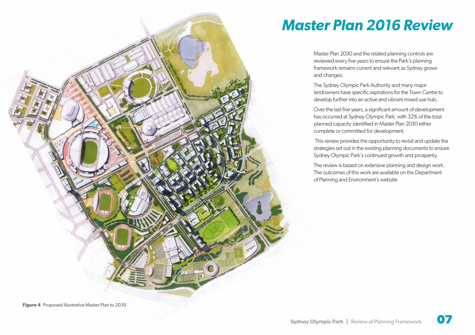
Master Plan 2030 and the related planning controls are reviewed every five years to ensure the Park’s planning framework remains current and relevant as Sydney grows and changes.
The Sydney Olympic Park Authority and many major landowners have specific aspirations for the Town Centre to develop further into an active and vibrant mixed use hub.
Over the last five years, a significant amount of development has occurred at Sydney Olympic Park, with 32% of the total planned capacity identified in Master Plan 2030 either complete or committed for development.
This review provides the opportunity to revisit and update the strategies set out in the existing planning documents to ensure Sydney Olympic Park’s continued growth and prosperity.
The review is based on extensive planning and design work. The outcomes of this work are available on the Department of Planning and Environment’s website
Figure 4 Proposed illustrative Master Plan to 2030

08 Sydney Olympic Park | Review of Planning Framework
Community Consultation
Consultation activitiesIn line with the vision for the Town Centre to become a more active place, Sydney Olympic Park Authority’s Consultation Strategy has guided engagement with stakeholders. These include relevant government agencies and Sydney Olympic Park landowners and leaseholders, who will have a major role in supporting and implementing this vision. The exhibition will provide an opportunity for their formal input into the Master Plan review.
Consultation activity has included:
• presentations and regular updates to the Sydney Olympic Park Authority Board
• introductory workshop and targeted meetings with Department of Planning and Environment, Transport for NSW, Roads and Maritime Services, the Department of Premier and Cabinet, the Department of Education, the Office of Sport, the Department of Health, the Environment Protection Agency and the Office of Environment and Heritage to consider matters such as traffic and transport, school requirements, noise, odour and contaminated lands management
• briefings for staff of the City of Parramatta (the new local government authority for the area)
• liaison with the Greater Sydney Commission in the development of a strategic vision for the Greater Parramatta to Olympic Peninsula
• ongoing engagement with key community stakeholders that represent the Park community including local councils,
business groups, education institutions, sports and events representatives
• introductory workshop and one-on-one meetings to discuss issues and aspirations with the major venues, landholders and leaseholders.
Key issues
Consultation found that stakeholders want the review to:
• enhance the Sydney Olympic Park’s unique qualities
• provide more flexibility for mixed use development and street life
• provide community facilities and services locally so the Olympic peninsula community does not need to travel elsewhere for basic needs
• sensitively handle the interface between commercial and residential development
• ensure major events are not jeopardised by increased residential uses
• integrate residential and retail uses with commercial offerings
• where possible, provide parking for commercial vehicles on site to minimise parking issues
• improve local intersections
• ensure retail and community facilities serve both employees and future residents and complement events at Sydney Olympic Park
• mitigate noise through siting, orientation and design of residential buildings
• improve bus and train frequencies to support sustainable travel
• improve access throughout the Town Centre through better pedestrian amenity and a local shuttle
• provide an increased range of transport options, in particular a light rail corridor
• address local and subregional road network access and congestion issues
• continue to focus on environmental sustainability as a priority.
• A 3D fly through video of the proposed changes is available to be viewed on both the Department of Planning and Environment and Sydney Olympic Park Authority websites. www.planning.nsw.gov.au/olympicpark www.sydneyolympicpark.com.au/future
The review is based on extensive planning and design work. The outcomes of this work are available on the Department of Planning and Environment’s website.
Next steps
The proposed changes that have resulted from the review are now open for public feedback.
The Sydney Olympic Park Authority will also be holding stakeholder and community briefings during which there will be further opportunities for submissions to be made.
To find out how you can attend a briefing or make a submission, visit www.planning.nsw.gov.au/olympicpark www.sydneyolympicpark.com.au/future
The Authority will then consider public feedback as the review is finalised, which may include additional investigations.
The Department of Planning and Environment will then consider the proposed amendments to Master Plan 2030 and the Sydney Olympic Park State Significant Precincts listing before making recommendations to the Minister for Planning.

Sydney Olympic Park | Review of Planning Framework 09
Next Steps
Briefing presentations by Department of Planning and Environment and Sydney Olympic Park Authority
World Café session Feedback and ideas for Master Plan review
We are here
CommunityStakeholderconsultations*- meetings- workshops- briefings
Master Planreviewcommenced
PublicExhibition
Dra� changes to Master Plan (2030) approved by SOPA Board
Reviewed by Department of Planning &Environment
Finalise changes toMaster Plan(2030)
Master plan approved by Minister for Planning & SEPP amendments gazetted
StakeholderConsultation
ReviewSubmissions
*Consultation undertaken by Sydney Olympic Park Authority

10 Sydney Olympic Park | Review of Planning Framework
To Parramatta
To Parramatta
WentworthPoint
WentworthPoint
Sydney Olympic Park Ferry Wharf
Rydalmere
Meadowbank
RHODES
CONCORDWEST
To HurstvilleTo Burwood
NORTHSTRATHFIELD
SYDNEYOLYMPIC
PARK
LIDCOMBE
AUBURN
HOMEBUSH
To C
hatsw
ood
Newington
CarterStreet
1
2
4
3
5
Existing Transport Network
Road and rail networkThe key road connections into the Town Centre are:
1 Australia Avenue/Homebush Bay Drive
2 Hill Road/Parramatta Road
3 Holker Street/Hill Road
4 Bennelong Parkway/Marjorie Jackson Parkway
5 Birnie Avenue/Parramatta Road.
Olympic Park Train Station, served by the T7 Olympic Sprint Line off the T1 Western Line from Lidcombe, is in the heart of the Town Centre, making it easy for people to travel to and from the Park by train. Direct services travel to and from Central Station via Strathfield on major event days.
Currently, 28% of trips to and from Sydney Olympic Park are made without a car, including trips by train, bus, by bike and on foot.
Bus, cycle and walking networkSeveral bus routes link Sydney Olympic Park to Lidcombe, the Sydney Olympic Park Ferry Wharf, Hurstville, Parramatta, Strathfield, Burwood and Chatswood. Major bus stops are located on Australia Avenue, Dawn Fraser Avenue and Edwin Flack Avenue and are accessible for people with mobility impairments.
Sydney Olympic Park features 35 kilometres of walking and cycling paths and cycleways. The bicycle network combines on-road lanes and off-road shared pathways.
The pattern of interconnected streets in the Town Centre makes it easy and convenient to walk or cycle.
Figure 5 Public transport network
Local Bus
Suburban Bus
Ferry Route/Ferry Wharf
Walking Route to Concord West
Olympic Sprint – Lidcombe Shuttle (T7)
Western Line/Blue Mountains Line (T1)
Northern Line/Newcastle/Central Coast Line
Direct Event Rail Services
Sydney Olympic Park | Review of Planning Framework 11
Strategic Centre
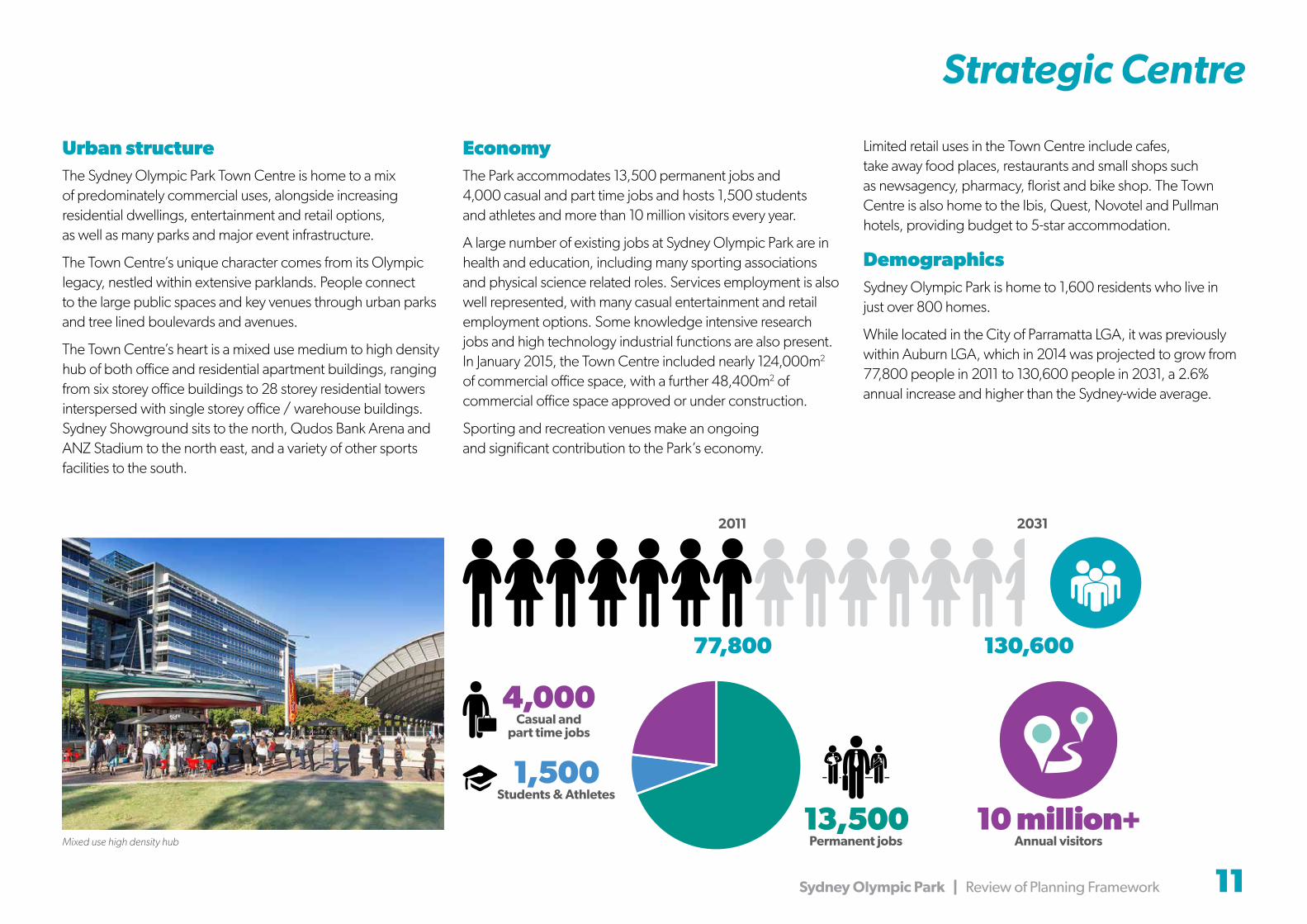
Urban structureThe Sydney Olympic Park Town Centre is home to a mix of predominately commercial uses, alongside increasing residential dwellings, entertainment and retail options, as well as many parks and major event infrastructure.
The Town Centre’s unique character comes from its Olympic legacy, nestled within extensive parklands. People connect to the large public spaces and key venues through urban parks and tree lined boulevards and avenues.
The Town Centre’s heart is a mixed use medium to high density hub of both office and residential apartment buildings, ranging from six storey office buildings to 28 storey residential towers interspersed with single storey office / warehouse buildings. Sydney Showground sits to the north, Qudos Bank Arena and ANZ Stadium to the north east, and a variety of other sports facilities to the south.
EconomyThe Park accommodates 13,500 permanent jobs and 4,000 casual and part time jobs and hosts 1,500 students and athletes and more than 10 million visitors every year.
A large number of existing jobs at Sydney Olympic Park are in health and education, including many sporting associations and physical science related roles. Services employment is also well represented, with many casual entertainment and retail employment options. Some knowledge intensive research jobs and high technology industrial functions are also present.In January 2015, the Town Centre included nearly 124,000m2 of commercial office space, with a further 48,400m2 of commercial office space approved or under construction.
Sporting and recreation venues make an ongoing and significant contribution to the Park’s economy.
Limited retail uses in the Town Centre include cafes, take away food places, restaurants and small shops such as newsagency, pharmacy, florist and bike shop. The Town Centre is also home to the Ibis, Quest, Novotel and Pullman hotels, providing budget to 5-star accommodation.
DemographicsSydney Olympic Park is home to 1,600 residents who live in just over 800 homes.
While located in the City of Parramatta LGA, it was previously within Auburn LGA, which in 2014 was projected to grow from 77,800 people in 2011 to 130,600 people in 2031, a 2.6% annual increase and higher than the Sydney-wide average.
Mixed use high density hub10 million+
Annual visitors13,500
Permanent jobs
4,000Casual and
part time jobs
1,500Students & Athletes
130,60077,800
20312011

12 Sydney Olympic Park | Review of Planning Framework
ViewsSydney Olympic Park contains important views to:
• the northern water feature and Newington Village along Olympic Boulevard
• the Tennis Centre along Olympic Boulevard
• the surrounding parklands
• Sydney CBD and Chatswood
• ANZ Stadium, the former Olympic Stadium.
Site Constraints and Considerations
Noise and odourParts of Sydney Olympic Park can be noisy, mainly during sporting and entertainment events. Sydney Olympic Park Authority uses public positive covenants to ensure landowners and tenants acknowledge the environmental and operational conditions that arise from sporting and entertainment activities.
Homebush Bay Liquid Waste Treatment Plant and the Auburn Resource Recovery Centre in the west of the Town Centre have the potential to create odour. The Environment Protection Agency (EPA) currently regulates the Treatment Plant under an Environmental Protection Licence and has been working with the facility operator to deliver substantial improvements in relation to odour controls at the plant over the last 12 years.
The current lease for the liquid waste treatment plant expires in 2025.
Parklands surrounding the Town Centre
Open space, ecology and watercoursesSydney Olympic Park Town centre is surrounded by 430 hectares of Parklands. The Parklands include four kilometres of water frontage to Parramatta River and Homebush Bay and include:
• leisure and play areas at Millennium Parklands, Bicentennial Park, Wentworth Common and Blaxland Riverside Park
• sportsgrounds at Wilson Park and Archery Park
• Monster skatepark and Mountain X facilities
• the State heritage-listed Newington Armory
• Newington Nature Reserve and Badu Mangroves
• the Brickpit and 100 hectares of wetlands and waterways.
Cathy Freeman Park east of Olympic Boulevard includes playgrounds, fitness areas and picnic areas as well as the State heritage-listed Olympic Cauldron. It is also occasionally used for events. A number of smaller open spaces are scattered around the Town Centre providing areas for relaxation and recreation.
HeritageSydney Olympic Park sits on the traditional lands of the Wann clan, known as the Wann-gal. These lands stretched along the southern shore of the Parramatta River between what is known today as Cockle Bay and Rosehill.
The land has a long history of early colonisation, pastoralism, naval and industrial activities including the State Abattoir. The land was subsequently regenerated and hosted the Olympic Games in 2000.
The Olympic Cauldron in Cathy Freeman Park was listed on the State Heritage Register in September 2010. The listing notes its significance as physical evidence of the Games opening ceremony and as a reminder of Sydney’s success and honour in having hosted the Millennium Games.
Parts of the Millennium Parklands and the State Abattoir are protected as local heritage conservation areas.

Sydney Olympic Park | Review of Planning Framework 13
Site Constraints and Considerations
The majority of land at Sydney Olympic Park is owned by the NSW Government. Three allotments in at the eastern edge of the Town Centre have been sold to private ownership and are occupied (or in the process of being occupied) by residential apartment buildings.
Some of the NSW Government-owned land is subject to individual leases negotiated by Sydney Olympic Park Authority with third parties.
Recent developmentSince 2000 $2.7 billion of development has been completed at Sydney Olympic Park. 32% of commercial and residential development allowed under the Master Plan 2030 is now complete or committed to.
Developments or expansions completed in the last five years include:
• commercial sites along Dawn Fraser Avenue, Murray Rose Avenue, Herb Elliott Avenue and Olympic Boulevard
• residential towers along Australia Avenue
• minor expansion to ANZ Stadium and Qudos Bank Arena
• an upgrade to Sydney Showground Stadium, now called Spotless Stadium
• an expansion to Sydney Showground exhibition halls along Showground Road
• redevelopment of the golf centre into the Tom Wills Oval and construction of the Greater Western Sydney Giants AFL Centre
• Netball Central, with associated parking
• new streets and street upgrades
• new parks and open space
• a sustainable wetland leachate treatment system adjacent to Boundary Creek.
Figure 6 Land ownership plan
Commercial buildings along Dawn Fraser Avenue
Residential towers along Australia Avenue
Tom Wills Oval
Netball Central
Sydney Olympic Park Authority
National Parks and Wildlife Service
Waste Service NSW
Privately Owned Land
Sydney Olympic Park
Sydney Olympic Park Town Centre

14 Sydney Olympic Park | Review of Planning Framework

Sydney Olympic Park | Review of Planning Framework 15
1,600Residents in
17,500Jobs
800Homes
1,500Students
Future Desired Character
“An active and energised Town Centre”This review has been guided by the clear objective of creating an active and energised Town Centre.
Sydney Olympic Park will be the urban hub of the Olympic Peninsula, providing a comprehensive range of facilities and services that support residents and workers and enables business to prosper.
Visitors will enjoy a unique array of activities and services that support and complement all events and create a vibrant day and night economy.
The Town Centre will be accessible to residents, visitors and workers and will seamlessly integrate with its surrounding communities and the rest of Sydney through a network of public transport, streets, pedestrian and cycleways.
Building on the Park’s attributes the Town Centre will embody the Olympic values and principles of Master Plan 2030, to create a distinctive, sustainable and exemplary urban centre.
This character will be supported by the Sydney Olympic Park Authority’s principles that guide future development (from the draft Master Plan - 2016 review):
Employment • regenerate land to create commercial office space
Urban Hub • increase residential, retail and educational land uses
• employ a mixed land use development strategy to provide both significant housing and employment opportunities
World Class Events • maintain and expand event venues and major event coordination
• recognise that events continue to be a fundamental feature of regular operations
Built Form • ensure a diverse and innovative built form provides a high quality living environment
Open Space • enhance the network of publicly accessible open spaces
Sustainability • apply best practice to environmental sustainability in development and operations
Town Centre Today Proposed Master Plan 2030
23,500Residents in
34,000Jobs
10,700Homes
5,000Students

16 Sydney Olympic Park | Review of Planning Framework
The Proposal
The 2016 review of Master plan 2030 proposes a number of changes to land use and development controls to achieve the outcomes set out below.
Urban structure and land useThe review aims to provide a compatible and diverse range of land uses in the Town Centre to accommodate future growth. This will strengthen the Town Centre’s urban structure by:
• reinforcing activity on major streets such as Olympic Boulevard, Dawn Fraser Avenue and Murray Rose Avenue
• continuing to separate major land uses in the Town Centre, with major events and sporting activities to the west and south of Olympic Boulevard, the Showground to the north, commercial/mixed uses close to the civic core and residential uses generally in the east and south east overlooking the parklands
• integrating educational uses with existing sports facilities and commercial and retail uses to promote day and night activity
• integrating civic and community uses through the Town Centre to complement retail and commercial uses
• creating opportunities for day and night time economy that supports a range of activities before and after events.
The review proposes additional gross floor area (GFA) for most land uses, which equates to an extra 460,000m2 GFA.
The potential for new residential dwellings has increased significantly in line with the NSW Government policy to focus residential development around transport hubs. This has led to a proposed reduction in commercial GFA.
gnikraP
NEW STREET
NEW STREET
NEW STREET
NEW STREET
NEW STREET
NEW
STREET
NEW
STREET
NEW
STREET
NEW STREET
NEW STREET
NEW ST
NEW STREET
NEW STREET
NEW STREET
NEW STREET
NEW
STREET
NE
W S
TRE
ET
NE
W STR
EET
NEW
STREET
NEW
STREET
NEW SERVICE STREET
NEW
STREET
NEW
STREET
NEW
STREET
NE
W S
TRE
ET
NEW STREET
WING PARADE
JOHN IAN
OLYM
PIC BO
ULEVAR
D
AUSTR
ALIA AVENU
E
SINNETERTNEC
ZNAMUIDATS
THE ARENA
DNUORGWOHS
EHTEMOD NOITIBIHXE SLLAH
CITAUQAERTNEC
NOITATS
2P
3P
4P
NWAD RESARF EUNEVA
ED
WIN
FLAC
K A
VE
NU
E
ED
WIN
FLAC
K A
VE
NU
E
BIRNIE AVENUE SHANE GOULD AVENUE WEST
SARAH DURACK AVENUE
SHIRLEY STRICKLAND AVENUE
DOR REVAL EVIRD
FIGTREE DRIVE
HERB ELLIOTT AVENUE
PA
RK S
TRE
ET
SHIRLEY STRICKLAND AVENUE
OLY
MP
IC B
OU
LEV
AR
D SO
UTH
NWAD RESARF EUNEVA
BENNELONG P
ARKWAY
WEN TEERTS
YRRUM ESOR EUNEVA
SARAH DURACK AVENUE
1P
CITELHTAERTNEC
MRAW PU ANERA
STROPSERTNEC
YEKCOHERTNEC
YEKCOHDLEIF
BARRIER ST
HILL ROAD
EDWIN FLACK AVENUE
OLD HILL LINK
PONDAGE LINK
NEW STREET
(WITH O
N STREET COACH PARKING)NEW STREET
WING PARADE
JOHN IAN
6P
NIVEK SBMOOC EUNEVA
OLYM
PIC BO
ULEVAR
D
DNARG EDARAP
AU
STR
ALIA
AV
EN
UE
YARRUM ESOR EUNEVA
SH
OW
GR
OU
ND
RO
AD
WEN DNALGNE EUNEVA
NREHTRON SREVIR EUNEVA
ECNERALC EUNEVA
MA
CQ
UA
RIE
STR
EE
T
OR
AN
A P
AR
AD
E
BA
RW
ON
AV
EN
UE
RUHTRACAM TEERTS
CU
MB
ER
LAN
D S
TRE
ET
YHTAC NAMEERF KRAP
AU
STR
ALIA
AV
EN
UE
HO
LKE
R S
TRE
ET
WEN TS
EIROJRAM NOSKCAJ YAWKRAP
NEW STREET
NEW
STR
EET
WEIVKRAP EVIRD
WEN TS
WEN TS
gnikraP
gnikraP
gnikraP
gnikraP
gnikraP
SHANE GOULD AVENUE EAST
GIFEVORG
SP
OR
TS W
ALK
LORRAINECRAPP WALK
NE
W S
TRE
ET
NE
W S
TRE
ET
NE
W S
TRE
ET
STR
EE
T
WEN TEERTS
7P
LOR
RAI
NE
CR
APP
LLABTENLARTNEC
NE
W
Public Domain
Residential
Commercial
Mixed Commercial and Residential
Community Uses
Mixed Commercial and Entertainment
Educational
Entertainment
Hotels and Serviced Apartments
Venue Expansion Zone
Venue and Operational Uses
Car Parking, Coach Parking and Rail Corridor
Land Dedicated for Infrastructure Contributions Framework Funded Streets
Land Dedicated for Development Funded Streets
Subject to Future Master Plan Study
Mixed Commercial, Hotels and Serviced Apartments
Land Use DevelopmentMaster Plan 2030
(m2)2016 Review
(m2)
Residential 575,000 855,000
Commercial Office 479,000 412,000
Venues (additions to exist) 130,000 110,000
Education 105,000 186,000
Temporary Accommodation
81,000 192,000
Transport Infrastructure 51,000 51,000
Retail 33,000 100,000
Community Facilities 31,000 37,000
Entertainment 15,000 17,000
TOTAL 1,500,000 1,960,000
Existing and proposed land use floorspace areas within the Town Centre
PrecinctMaster Plan 2030
(m2)2016 Review
(m2)
Sydney Showground 70,000 70,000
Central Sports 165,000 180,000
Central 570,000 785,000
Parkview 320,000 427,000
Haslams 208,000 208,000
Tennis 27,000 27,000
Stadia 40,000 137,000
Boundary Creek 60,000 76,000
Southern Sports 40,000 50,000
TOTAL 1,500,000 1,960,000
Existing and proposed floorspace areas by precinct
Figure 7 Proposed land uses plan

Sydney Olympic Park | Review of Planning Framework 17
Built Form
DesignBuilt form can serve both aesthetic and practical objectives and new buildings will contribute to a mixed use, compact and well defined Town Centre that reinforces the Park’s strong legacy of design excellence.
The Master Plan review aims to:
• use building design and location to screen residential developments from event noise
• activate street frontages with uses that occur at the footpath level
• reduce the impact of car parking on public areas by locating new car parking facilities underground
• limit floor plate areas for towers over 25 metres high to maintain a skyline of slender buildings
• protect and enhance existing heritage and the Olympic legacy.Desired future built form and design
Shadow study diagrams during June
Shadow studyA shadow study indicates where overshadowing might occur, following proposed changes to building heights, form and location. Some overshadowing impacts will require mitigation.
The proposed changes minimise overshadowing impacts by:
• requiring buildings over eight storeys, and notably taller tower buildings, to be orientated north-south
• more flexible height controls for perimeter style development to improve solar access to internal courtyards and southern edges of development sitessiting lower scale buildings to the north and west of parks and specific controls to provide solar access to public areas
• using tower separation controls to distribute shadows evenly across the Town Centre.
9am June 12pm June 3pm June

18 Sydney Olympic Park | Review of Planning Framework
Access and Transport
The review proposes the following transport and access initiatives:
• expand the street network to make it easier to walk and cycle and increase connections to, from and within Sydney Olympic Park
• provide a dedicated service street to support the mixed use commercial centre within the Town Centre
• use changes in road levels to create connections or crossings over busy streets and railway lines.
The review aims to increase the proportion of non-car trips made by people working in the Park to 40%. This requires major public transport improvements including:
• a Light Rail connection between Parramatta and Strathfield
• street upgrades to create adequate width for future transit opportunities
• a bus service from the Park to Rhodes Station across Bennelong Bridge through Wentworth Point
• upgrades to Lidcombe and Concord West Stations
• using event bus routes for timetabled bus services.
Additional traffic impacts of changes to land uses are anticipated to be managed through the key initiatives already identified within Master Plan 2030. Therefore the proposed upgrades are fundamentally unchanged.
The review’s emphasis on residential, retail and venue land uses provides opportunities to control traffic generation and increase the use of the public transport.
Providing additional dwellings in the Town Centre encourages people to live and work there.
The review does not propose amending the existing maximum vehicle parking rates. It is proposed that parking rates will be continually monitored and reviewed.
Figure 8 Street hierarchy plan
Infrastructure Contributions Framework Funded Civic Streets
Infrastructure Contributions Framework Funded Perimeter Avenues and Connecting Streets
Infrastructure Contributions Framework Funded Town Streets
Infrastructure Contributions Framework Funded Local Streets
Pedestrian Connections or Bridge Pedestrian Connections
Development Funded Streets
Through Site Link
To Parramatta
To Parramatta
WentworthPoint
WentworthPoint
Sydney Olympic Park Ferry Wharf
Rydalmere
Meadowbank
RHODES
CONCORDWEST
To HurstvilleTo Burwood
NORTHSTRATHFIELD
SYDNEYOLYMPIC
PARK
LIDCOMBE
AUBURN
HOMEBUSH
To C
hatsw
ood
Newington
CarterStreet
Figure 9 Public transport plan
Local Bus
Suburban Bus
Promoting the use of event bus routes for timetabled services
Potential SOP shuttle bus
Ferry Route/Ferry Wharf
Walking Route to Concord West
Olympic Sprint – Lidcombe Shuttle
Western Line/Blue Mountains Line
Northern Line/Newcastle/Central Coast Line
New station upgrades
Direct Event Rail Services
Future Parramatta Light Rail (indicative alignment only)
New streets around new park
Relocation of through site link to a more central location
New pedestrian bridge across
Sarah Durack Avenue
Street reconfigured to connect Olympic Boulevard to Sarah Durack Avenue
Through site links added to new development site to facilitate connections
to Carter Street
Removal of street and reconfiguration of through site link to
reflect consolidation of adjacent building sites
Establishing the Light Rail Corridor through
Sydney Olympic Park
New bus service to Rhodes Train Station
across Bennelong Bridge
New streets added to improve connectivity, provide a finer grain
network, promote pedestrian activity, create active frontages and
provide separate service access
New streets

Sydney Olympic Park | Review of Planning Framework 19
Open Space and Community Uses
Public open spacesPublic areas within the Town Centre include large public spaces designed for major events. The review proposes new parks to create an attractive, memorable and liveable Town Centre.
The proposed expansions to the open space network can reinforce the legacy of design excellence at the Park by:
• providing for a broader range of recreational uses
• using the street network to guide landscaping in the Town Centre
• promoting security and natural surveillance
• creating more relaxing and shaded areas within the Town Centre
• ensuring high standards of planning, design and detailing in all public domain projects.
Community usesThe review will make suitable community facilities available in the right locations and within the right timescales to meet the demands of a growing community.
The review proposes a new community hub that includes a library and multi-purpose community centre.
The Department of Education is investigating the need for a high school on the Olympic Peninsula. This review includes two potential locations for a new school site. The NSW Government’s preferred location for a new government high school is on the corner of Australia Avenue and Homebush Bay Drive, where best use can be made of existing open space facilities.
Events Places
1 Olympic Boulevard and Plaza
2 Yulang Square
3 Fig Grove
Urban Parks and Places
4 Cathy Freeman Park
Urban Places
5 Station Square
6 Jacaranda Square
7 Stockroute Park
8 Abattoir Garden
9 Brickpit Park
Local Parks
Widened landscape corridor
Public Parklands
Venue or Building Forecourts
Public Space Shared with Venues
6
7
1
4
2
3
58
9
Parks (revised in-line with new planned public open space)
Community Facilities (possible locations)
School (possible locations)
Childcare Centres (possible locations)
Figure 10 Planned public open space plan
Figure 11 Community facilities plan
Increased public space
New urban park
New local park outside town centre
Widened landscape corridor
Possible community facilities and childcare centres
located throughout the Town Centre
Possible school sites
Proposed primary school at
Carter Street
Enlarged local park

20 Sydney Olympic Park | Review of Planning Framework

Sydney Olympic Park | Review of Planning Framework 21
Precincts
Summary of proposed Master Plan changes for each precinctThe following pages summarise the review’s proposed changes on a precinct-by-precinct basis. Most changes are proposed for Central, Stadia and Parkview Precincts, with minor changes proposed for Boundary Creek and Tennis, Central Sports and Southern Sports Precincts.
As the review does not propose any changes to the Haslams and Sydney Showground Precincts, these precincts are not addressed in this portion of the document. However, a Master Plan Study will be undertaken for the Showground Precinct in the future.
Where these Master Plan changes require amendments to the planning controls (in the State Environmental Planning Policy (State Significant Sites) 2005) these are summarised in the proposed planning controls section of this document.
Major Changes Minor Changes No Changes
Figure 12 Proposed amendments by precinct

22 Sydney Olympic Park | Review of Planning Framework

Sydney Olympic Park | Review of Planning Framework 23
For the Central Precinct to grow into a vibrant mixed-use centre, the review proposes a greater mix of uses while also improving connectivity with new streets and public open space. The review proposes non-residential uses and built form to buffer residential uses from event noise.
Proposed changes to the Central Precinct are shown on the land uses plan and include:
1 improving access and permeability throughout the Precinct with additional streets to support a diversity of land uses, provide more convenient and direct routes to key destinations, enhance the Precinct’s character and improve pedestrian amenity
2 providing a new service street for separate service vehicle, delivery and car park access away from formal street fronts
3 including a pedestrian connection to the Boundary Creek Precinct to the south via a bridge across Sarah Durack Avenue
4 changing land use controls to encourage more mixed use development and promote after-hours activity, especially along Australia Avenue and Olympic Boulevard (as well as links through the Precinct) and around the new central park
5 consolidating a commercial core to promote new jobs supported by a retail hub close to the railway station, future light rail and
6 reconfiguring open spaces to create a large, centrally located public urban park to:
a. provide for informal recreation and create a strong identity to the Precinct
b. maximise sun access across the Precinct
c. allow more people to enjoy substantial views
d. create visual and physical connections across the heritage Abattoir Gardens, through to the stadium and showground buildings
7 significantly widening the linear park south of the Precinct to expand recreational uses and to create a setting for new residential buildings and a continuous green ecological, pedestrian and cycle link from Southern Sports Precinct through to Bicentennial Park
8 changing building heights to align the tallest towers along north-south streets: Australia Avenue (30 storeys) and the Olympic Boulevard (45 storeys) to reinforce the
significance of these streets.
Additional changes comprise:
• providing additional continuous retail uses along streets in the commercial and mixed use areas to create an active and pedestrian-friendly shopping area, particularly around the new central park
• identifying possible locations for new community facilities and child care facilities
• changing building heights to:
- provide block edge podium development of six to eight storeys, with two storey retail along primary retail streets and within the commercial core generally
- maintain a skyline of slender towers from 20 to 45 storeys, set back above the podium bases
• changing building zones and setbacks to ensure well defined street edges, encourage continuous active frontages throughout the precinct and appropriate placement of tower development above a podium base
• changing the FSR on currently underdeveloped sites to encourage high quality development and activity
• making all developments subject to mandatory design excellence processes
New Site Boundary
Preferred Vehicular Access
Public Domain
Residential
Commercial
Community
Hotels and Serviced Apartments
Mixed Commercial, Residential, Hotels and Serviced Apartments (no Residential or Serviced Apartments on ground level)
Rail Use
Land Dedicated for Infrastructure Contributions Framework Funded Streets
Land Dedicated for Development Funded Streets
0 75m 150m
Figure 13 Central Precinct land uses plan
Central Precinct
73
2
2
1
11
1
1
5
4
44
44
4
4
4
4
6
88

24 Sydney Olympic Park | Review of Planning Framework

Stadia Precinct
0 75m 150mO
LYMPIC
BOU
LEVARD
MUIDATSNA Z
EUNEVARA ESRFNWAD
ED
WIN
FK
CAL
AV
EN
UE
1PgnikraP
THE ARENA
EDWIN FLACK AVENUE
Figure 14 Stadia Precinct land uses plan
Sydney Olympic Park | Review of Planning Framework 25
The review seeks to further enhance Sydney Olympic Park’s role as a world-class sports and major events venue while creating opportunities for a broader range of complementary activity outside major events.
The Stadia Precinct is dominated by ANZ Stadium and Qudos Bank Arena. These are surrounded by expansive forecourt areas that host large crowds and temporary activities and structures for major events.
The proposed changes will provide opportunities to activate the areas around the venues both during and outside of major events while retaining easy access for the high volume of pedestrians to and from the venues.
Dawn Fraser and Edwin Flack Avenues and Olympic Boulevard will be the focus for new retail and commercial uses to make these streets more active and interesting, and to better link into the wider pedestrian networks of surrounding precincts and the future street network of the Carter Street precinct.
Proposed changes to the Stadia Precinct include:
1 expanding the ANZ Stadium site to allow infill development up to Olympic Boulevard, Dawn Fraser and Edwin Flack Avenue frontages with a 20 metre through-site link connecting the Boulevard with Edwin Flack Avenue at the north creating a buffer to Qudos Bank Arena
2 creating new uses within the ANZ Stadium site to address and define street edges including Edwin Flack, Dawn Fraser Avenues and Olympic Boulevard
3 changing uses from a Venue Expansion Zone to Mixed Commercial and Entertainment to encourage greater diversity
4 setting a maximum height of buildings (8-10 storeys) to retain the visual dominance of the Boulevard light structures and the profile of ANZ Stadium
5 slightly enlarging the Venue Expansion Zone adjacent to Qudos Bank Arena and changing its land use category to Entertainment to create greater diversity of activity
6 modifying the western boundary to the coach parking site on the western side of Edwin Flack Avenue to provide for a future street as part of the works on the adjacent Carter Street Precinct
7 changing the Coach Parking site from parking uses to Mixed Commercial/Hotels/Serviced Apartment uses to complement events and future development around the ANZ Stadium and adding through site links to the Carter Street Precinct
8 increasing maximum building heights and development densities for the Coach Parking site to form an acoustic buffer for the Carter Street Precinct
In addition, mandating that all developments are subject to design excellence processes.
New Site Boundary
Preferred Vehicular Access
Public Domain
Venues and Operational Zones
Car Parking, Coach Parking
Land Dedicated for Infrastructure Contributions Framework Funded Streets
Entertainment
Mixed Commercial and Hotels and Serviced Apartments
Mixed Commercial and Entertainment
5
1
3
7
8
6
24
7
7
Proposed built form and relationship to Carter Street

26 Sydney Olympic Park | Review of Planning Framework

Artists impression of the Parkview Precinct
Sydney Olympic Park | Review of Planning Framework 27
Parkview Precinct
The Parkview Precinct is establishing itself as a parkside residential neighbourhood with residents now moving in alongside commercial and retail uses. The review will strengthen the character of this precinct as a high quality and walkable neighbourhood.
Proposed changes to the Parkview Precinct are shown on the land uses plan and include:
1 increasing connectivity and walkability through new service streets to separate service traffic and car park entries from commercial streets
2 strengthening commercial uses along Dawn Fraser Avenue and Murray Rose Avenue East to secure commercial space and jobs growth within Sydney Olympic Park
3 increasing residential densities to ensure the highest and best use of high amenity sites
4 increasing building heights towards the northern and western edges of the precinct and maintaining a lower scale development profile for areas immediately adjacent to the Parklands to retain and maximise views across the Parklands, protect sun access and minimise impact on Parkland habitats
5 expanding and reconfiguring the central local park to create a more attractive and key hub for the community.
Additional changes comprise:
• identifying possible locations for community facilities and child care centres with the relocation of the school site to the Tennis Precinct
• increasing FSR to allow towers at some sites and more block-edge development (up to eight storeys) while protecting commercial uses and facilitating jobs growth
• amending setback and buildings zones to reflect changes in block edge and tower development and to reinforce the street hierarchy
• Introducing mandatory design excellence processes for high profile sites where density has increased.
New Site Boundary
Preferred Vehicular Access
Public Domain
Mixed Commercial and Hotels and Serviced Apartments
Residential
Commercial
Mixed Commercial Residential
Car Parking, Coach Parking and Rail Corridor
Land Dedicated for Infrastructure Contributions Framework Funded Streets
Land Dedicated for Development Funded Streets
Figure 15 Parkview Precinct land uses plan
53
3
2
3
3
3
3
3
3
4
4
4
1
1
1
1

28 Sydney Olympic Park | Review of Planning Framework
Boundary Creek and Tennis Precincts
Artists impression of the Boundary Creek and Tennis Precincts
The Boundary Creek and Tennis Precincts will remain a place for sporting activities and sports venues. The proposed changes include improvements in connectivity and increased sustainability of the sporting facilities with additional complementary uses:
1 new mixed use infill sites between P3 Car Park and Sarah Durack Avenue with maximum building height of two storeys will define the Sarah Durack Avenue frontage and integrate with future corner development at Olympic Boulevard
2 uses to sites fronting onto Olympic Boulevard will change from single uses (commercial, mixed use or residential) to a broader land use category (mixed commercial, residential, hotels and serviced apartments)
3 the review identifies a possible location for community facilities and a school site
4 the end of the new street off Olympic Boulevard, south of P3 Car Park, shortened and realigned to connect directly with Sarah Durack Avenue
5 a new pedestrian bridge across Sarah Durack Avenue will connect to the Central Precinct to the north
6 a new 10 metre Vegetated Riparian Zone setback to both sides of Boundary Creek.
In addition, amendments to the building heights, FSR and setbacks reflect the proposed land uses changes.
New Site Boundary
Preferred Vehicular Access
Public Domain
Venues and Operational Zones
Venue Expansion Zones
Education
Mixed Commercial , Residential, Hotels and Serviced Apartments
Car Parking, Coach Parking
Land Dedicated for Infrastructure Contributions Framework Funded Streets
Land Dedicated for Development Funded Streets
0 75m 150m
Figure 16 Boundary Creek and Tennis Precincts land uses plan
5
2
2
4
6
6
3
11
Artists impression of the Central Sports Precinct
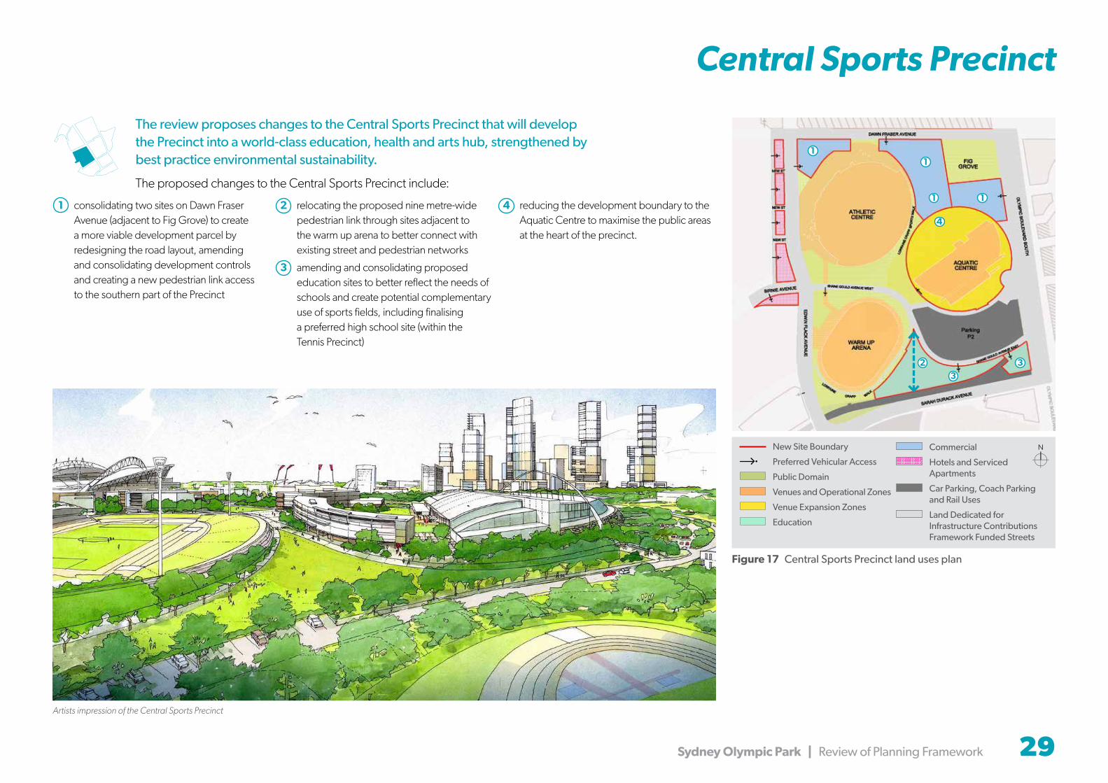
Central Sports Precinct
The review proposes changes to the Central Sports Precinct that will develop the Precinct into a world-class education, health and arts hub, strengthened by best practice environmental sustainability.
The proposed changes to the Central Sports Precinct include:
1 consolidating two sites on Dawn Fraser Avenue (adjacent to Fig Grove) to create a more viable development parcel by redesigning the road layout, amending and consolidating development controls and creating a new pedestrian link access to the southern part of the Precinct
2 relocating the proposed nine metre-wide pedestrian link through sites adjacent to the warm up arena to better connect with existing street and pedestrian networks
3 amending and consolidating proposed education sites to better reflect the needs of schools and create potential complementary use of sports fields, including finalising a preferred high school site (within the Tennis Precinct)
4 reducing the development boundary to the Aquatic Centre to maximise the public areas at the heart of the precinct.
Figure 17 Central Sports Precinct land uses plan
New Site Boundary
Preferred Vehicular Access
Public Domain
Venues and Operational Zones
Venue Expansion Zones
Education
Commercial
Hotels and Serviced Apartments
Car Parking, Coach Parking and Rail Uses
Land Dedicated for Infrastructure Contributions Framework Funded Streets
23
4
1
11
1
3
Sydney Olympic Park | Review of Planning Framework 29

Figure 18 Southern Sports Precinct land uses plan
Artists impression of the Southern Sports Precinct
0 75m 150m
The review proposes minor changes to the Southern Sports Precinct to retain its role as a key sporting destination in the Park. These changes include:
1 designating a new site as a Venue Expansion Zone over P7 Car Park to the south of the Sports Centre and amending building heights to accommodate the future Sports Halls that will be relocated from the Showground Precinct and located over the car park
2 introducing a 10 metre Vegetated Riparian Zone setback to both sides of Boundary Creek.
New Site Boundary
Preferred Vehicular Access
Public Domain
Venues and Operational Zones
Venue Expansion Zones
Commercial
Car Parking, Coach Parking and Rail Corridor
Land Dedicated for Infrastructure Contributions Framework Funded Streets
2
1
30 Sydney Olympic Park | Review of Planning Framework
Southern Sports Precinct

Sydney Olympic Park | Review of Planning Framework 31
Explanation of Intended Effect
BackgroundSchedule 3 of State Environmental Planning Policy (Major Development) 2005 (Major Development SEPP) was amended in 2009 to include provisions for the development of Sydney Olympic Park in Part 23. The changes proposed to Master Plan 2030 by the review require changes to the development controls in Part 23 of Schedule 3.
In March 2016, the Major Development SEPP was amended to the State Significant Precincts SEPP. The proposed SEPP seeks to amend Part 23 of Schedule 3 of the State Significant Precincts SEPP in relation to Sydney Olympic Park.
Proposed SEPP Clause AmendmentsThe following clauses will be amended by the proposed SEPP:
Clause 2 Interpretation
• Map definitions will be amended where the names of maps change as a result of the proposed SEPP;
• The definition of ‘heritage conservation area’ will be amended to change ‘Millennium Parklands’ to ‘Newington Armament Depot and Nature Reserve’
• The definition of ‘heritage item’ will be amended to: o Update references to the most recent 2013 conservation
management plans for both (a) and (b); and
o Add Olympic Cauldron
• The definition of ‘major event venue’ will be amended as follows:
o (e) the Golf Centre will be changed to ‘Greater Western Sydney Training Centres and Tom Wills Oval’;
o (h) The Overflow will be changed to ‘Cathy Freeman Park’;
o (o) Blacksland Riverside Park will be changed to ‘Blaxland Riverside Park’;
o (p) Newington Armory will be changed to ‘Newington Armament Depot and Nature Reserve’; and
o Addition of a new site (q) Netball Central.
• The definition of ‘Millennium Parklands Plan of Management’ will be amended to ‘Parklands Plan of Management’ and defined as the updated document that was adopted by the Minister on 8 November 2010.
Clause 14 Zone E3 Environmental Management
• Existing reference to ‘Millennium Parklands Plan of Management’ will be amended to ‘Parklands Plan of Management’.
Clauses 21 and 22 Exceptions to development standards – transitional Part 3A projects and other development
• Existing references to Director-General will be amended to Secretary.
Clause 30 Design Excellence
• Insert a new subclause that allows up to 10% additional floor space than the maximum shown on the floor space ratio map for buildings demonstrating design excellence.
• Existing reference to Director-General will be amended to Secretary.
Clause 32 Additional Permitted Uses – Site 62
• This clause will be repealed. The additional permitted use (high technology industry) is no longer required as it has already been developed on the site and can now be managed as an existing use.
• Clause 33 Additional Permitted Uses – Newington Armory site
• Existing reference to ‘Newington Armory’ will be changed to ‘Newington Armament Depot and Nature Reserve’.
• New Clause 35 Satisfactory Arrangements for the provision of regional infrastructure
• Insert a new clause that requires a consent authority to be satisfied that satisfactory arrangements have been made to contribute to the provision of regional infrastructure prior to consenting to development in the Sydney Olympic Park site.

32 Sydney Olympic Park | Review of Planning Framework
Explanation of Intended Effect
Proposed SEPP Map AmendmentsThe proposed SEPP will amend the following maps:
• Height of Buildings Maps
• Reduced Level Map
• Floor Space Ratio Map
• Heritage Map
• Land Zoning Map
For all maps to be amended, the base cadastre and site plan will be amended to align with the proposed Master Plan 2030 (2016 Review).
Height of Buildings Map
• Addition of new height categories to reflect Master Plan 2030 (2016 review): 50m, 74m, 102m and 149m.
• Application of new height categories to sites in Stadia, Central and Parkview Precinct as identified in Master Plan 2030 (2016 review).
• Removal of maximum building height controls from the Master Plan for sites 24 and 28 in the Central Sports Precinct, as these parcels are no longer proposed development sites (due primarily to site constraints)
• Consolidation of sites 18 and 26 in Central Sports Precinct to reflect the consolidation of these sites in Master Plan 2030 (2016 review). No change is proposed to the existing 26m maximum building height on these sites.
Reduced Level Map
• Removal of two categories, S2 (24m AHD) and Q (19m AHD) from the map. These values currently apply to Netball Central (site 107) the development of which is now complete so controls are no longer required.
• Apply category W (42m AHD) to site 114 around the stadium. This is a new development site identified in Master Plan 2030 (2016 review) and has not previously needed a control.
• Add a new category T1 (27m AHD) and apply to site 107A which is a new development site identified in Master Plan 2030 (2016 review) in Tennis precinct.
Floor Space Ratio Map
• Addition of new maximum floor space ratio categories to reflect Master Plan 2030 (2016 review): 2.2:1, 3.2:1, 3.6:1, 5.5:1 and 8:1
• Application of new floor space ratio categories to sites in Stadia, Central, Parkview, Central Sports and Boundary Creek and Tennis Precincts as identified in Master Plan 2030 (2016 review).
• Removal of floor space ratio controls from the Master Plan for sites 24 and 28 in the Central Sports Precinct, as these parcels are no longer proposed development sites (due primarily to site constraints).
• Consolidation of sites 18 and 26 in Central Sports Precinct to reflect the consolidation of these sites in Master Plan 2030 (2016 review). The consolidated site will have a floor space ratio of 2:1 (the western portion of the site (site 18) currently has an FSR of 4:1.
Heritage Map
• Conservation Area A State Abattoirs will be amended to remove Showground Road from its boundary. This is consistent with the findings of Abattoir Heritage Precinct Conservation Management Plan 2013.
• Conservation Area B Millennium Parklands will be renamed to ‘Newington Armament Depot and Nature Reserve’.
• A new heritage item, Olympic Cauldron, will be included reflecting this area’s State Heritage Register listing.
Land Zoning Map
• Removal of hatching that applies to site 62 as this site is no longer proposed to have an additional permitted use.
• Change ‘Newington Armory’ to ‘Newington Armament Depot and Nature Reserve’.

Sydney Olympic Park | Review of Planning Framework 33
Subject Land
Cadastre
Maximum Building Height (m)J 9
O 15P 18
R1 21R2 22S 24
T1 26T2 29U1 30U2 33Y 50
AA 74AB 90AC 102
AC1 122AD 149
1 New 45 storey tower zone (149m) increased from 9m /2 storeys
2 New 45 storey tower zone (149m) increased from 122m
3 New 20 storey tower zone (74m) increased from 30-33m
4 New 30 storey tower zone (102m) increased from 30-33m
5 New 30 storey tower zone (102m) increased from 33m
6 New 15 storey tower zone (50m) increase from 24m
7 Building heights increased from 15m to 26m
8 Building heights increased from 30-33m
New height control of 9m
Sites 24 and 28 removed from Master Plan
Proposed Building Height Amendments
Building form and scale contribute to the physical definition of the street network and how people use public spaces. The review includes amendments to a range of building heights across the Town Centre to:
• reinforce the urban structure of Sydney Olympic Park
• enhance the distinctive Olympic skyline by reinforcing the major north south streets that define the Town Centre
• encourage variety, diversity and different architectural styles
• screen residential uses from event noise.
Key changes to building heights are within the Central, Parkview and Stadia Precincts.
CO NWAY AV
STUA RT ST
VL A DIM IR K U T S AV
BER ON G A ST
HILLIER ST
GR AC EMER E ST
CH
AR
LT
ON
DR
M ICHA E L WE ND O N AV
CO R R E Y S AV
WUN DA RD
CAS TLESTE AD ST
NE
WI N
GT
ON
DR
MONT E R E Y S T
AV
EN
UE
OF
OC
EA
NI A
DARTB
RO
OK R
D
VORE
ST
SIMPSON ST
B O ORE A S T
CAR NA RVO N ST
DER BY ST
STUB
BS S
T
HOM
EB U
SH
BA Y
DR
ON
RA
MP
UN
D ER W
OO
D
RD
OL
YM
PIC
BV
D
KING
L
ELLA
ST
CO
NC
ORD
RD
FIGTREE
DR
MA NN ING ST
HUNTER ST
ILLA WAR RA ST
HO
NO
R ST
DA
VIE
S ST
CO
AL
ST
BLIGH ST
WE NT O N A V
B R E W E R AV
E L I Z A AV
BARRIERST
YARA LLA ST
FISHER ST
IV OR ST
DO
NN
EL
LY
CL
LIA
NE
TO
OT
HA
V
HU
ME ST
MO
NARO
ST
SHO
ALHAVEN
ST
NO
WIL
L ST
ABEB
EBI
KILA
ST
TULLOCH
AV
ME PU NG A S T
GR
EY S
T
L AR
ISA
LA
TYN
I NA
WK PHO
ENIX AV
MA RY ST W
GR AC E AV
PARK
ST
OULTO
N AV
CU
MBER
LAND
ST
HA
WK
ESBU
RY S
T
THEIL AV
BE
RN
I E
AV
DEN HA M ST
OU
L TO
N
AV
N
MAC
QU
ARIE
ST
STATIO N AV
HEY SEN A V
J AN
ET
EV
AN
SA
V
NIRR AN DA ST
HALL ST
S USA N O
N E IL L AV
N ADIA C OM ANE C I
A V
EDITH ST
MA RY ST E
HA R
RI S
ON
AV
RIV
ER R
D
THA
CKE
RAY
ST
AUSTRA
LIA AV
RO
UNDABOU
T
RON
CLARK
EST
F R E DD IE
L ANEAV
SYLV
IA S
T
PIC
KEN
ST
SILV
ER S
T
NOO
R A S T
ARG O NN E ST
FALL
ON
ST
DAY ST
S
STATI
ON
RD
AN
DR
EW
CH
AR
LTO
NA
V
AVER ILL ST
LOC
H MAR
EE PDE
P A ULE LV S T R
OMA V
MA
RL
EN
E OT T E Y
AV
PRIM
RO
SE
AV
M Y AL L S T
TH ED R I VE
PARR AMATTA RD
I A NDRA S T
ME NA ST
BRU SSE LS ST
MELTO
N S
T S J O
NH
EN
RI C
KS
AV
LO R RAIN E S T
NICH O LAS S T
FREMO
NT ST
BARU
NG
A ST
SHA
FT S
T
CO LANE ST
DA
LE
YT
HO
MP
SO
NS
T
MAN
TON
AV
WILG
AL
WALLAR OY ST
SALISB UR Y S T
CHUR
CHILL
ST
STAN
LEY S
T
WIBLEN ST
SUTT
OR
ST
MARA
THO
N A
V
CA
RO
LYN
ST
BAR
WO
N A
V
WE
TH
ER
I LL
ST
S
GA UTH OR PE S T
R US S E
L LM
OC KR
I DGE
AV
C L Y DE S T
BLAXLA ND ST
ALBAN
ST
SIMLA ST
NULLA
WAR
RA AV
J OH
NK
ON R
AD
SAV
EVAN S ST
BURKE ST
LLE WELLYN ST
CLAR EN CE AV
SHO
WG
RO
UN
D RD
RAC HA EL C L
HASTINGS ST
GO O REE N S T
AVE NU E OFE
U R OP E
CA
VE
ND
ISH S
T
MOALA ST
FRAMP TON ST
S HI R L
E YS
T R I C KLA N
D
AV
PONDAGE LINK
ELIMATTA ST
CO ON O NG RD
LEEDS ST
RIVER ST
DEW RAN G ST
CALO O L ST
AL OE
RTE
R AV
MILLE NN IUM C T
MARQ
UE
T S
T
OLD HILL LINK
HO LKER ST
AVE N UE OF A S IA
NEW
ING
TON
RD
BAN GA LLA R DS N OW
Y BA K E R
AV
JOH
NIA N
WING
PDE
YA
RR
AM
ST
AV
EN
UE
OF
TH
EA
ME
RIC
AS
UH RIG RD
FR
AN
KB
EA
UR
EP
AIR
EAV
BARKER
AV
ALFRED
ST
BORO
NIA ST
MELTO
N S
T N
DEAKIN ST
BAC
HEL
L AV
GIFFA RD S T
KILLOOLA ST
MERVILLE
ST
VICTO R IA AV
CO NC OR D AV
CURR
AWAN
G ST
CA
VE
LL A
V
ADD ER LEY S T E
GA
LLIP
OLI
ST
SILV
ERW
ATE
R R
D
OLYM
PIC D
R
KING
S T
S ILV E R WAT E R R
D OF F
R A MP
MU R R AYR O S E AV
HOSPITA
L RD
GRANDPDE
SPURW
AY
ST
R I V E R I NA AV
HAR
RY A
V
E L L IOT
A V
OST
END
ST
SLO
UG
H A
V
ADD ER LEY S T W
BIR
NI E
AV
MO
NS
ST
GR AN D AV
DAWN F R AS E R
AV
N E WE NG
LA NDAV
JELLI
CO
E ST
S HANE GO UL D AV
EG ERTO N ST
DA
Y ST
NOR T HE R N R I V E R S AV
PLAT
FORM
ST
STH
ILLIE
RSRD
ASQ UITH ST
BEAC O NS FIELD S T
DEL
HI S
TBOMB
AY S
T
CO
NS
ETT ST
PER
CY ST
SA R
A HD
U RA C
KAV
FRAN
CE
S ST
JAM
IESO
N S
T
WA
LKE
R ST
CAR TER ST
BLA
XLA
ND
RD
JOH
N S
T
FA RIO LA S T
WE
TH
ER
I LL
ST
N
MAR J O R I E J AC K S ON P WY
HIL
L RD
HO
MEB
USH
BA
Y D
R
WESTERN
MW
Y
ROTH
WELL A
V
MAC
KEN
ZIE
ST
WE
NT
WO
RT
HD
R
TENTERFIELD
ST
QU
EEN ST
GE
OR
GE
ST
NYR
ANG
ST
SETTLERS BVD
THO
RPE
AV
HILD
ER RD
BI L
LR O
YC R
OFT
AV C
OL E
CR
MO
UL T
ON
AV
CU
RLEW
AV
CROPLEY ST
JO
HN
DE
VIT
TA
V
LA
TH
AM
TC
E
SANDPIPER
CR
MUHAM MEDA
LIPD
E
CAR
LLE
WIS
WY
CUMBE
RLAN
DSQ
HEIDELBERG AV
BO
BB
YP
EA
RC
EA
V
MA
RK
SP
ITZ
AV
AL E
XP
OP
OV
AV
LIN DS AY AV
P AAV ON U RM
IA
V
H O M E BU S H BAY D R O F F R AM P
J ES S
E
OW
EN S
A V
B L AX L AN D AV
BEN
NEL
ON
G R
D
ED
WIN
FLA
CK
A V
State Environmental Planning Policy(State Significant Precincts) 2005Sydney Olympic ParkHeight of Buildings Map
sheet HOB 001
PARRAMATTALGA
BURWOODLGA
CANADABAY LGA
STRATHFIELDLGA
CUMBERLANDLGA
Projection: MGA Zone 56Datum: GDA94
Map Identification Number
SEPP_SSP_SOP_HOB_001_20160609
Subject Land
Maximum Building Height (m)
J 9
O 15
P 18
R1 21
R2 22
S 24
T1 26
T2 29
U1 30
U2 33
Y 50
AA 74
AB 90
AC 102
AC1 122
AD 149
Cadastre
Cadastre 06/05/2016 © NSW LPI
0 150 300 450 m
Scale: @ A31:15,000
R1 R1
R1
R1 R1
R1 R1 R1
AD
T1
T1
R2R2
J
T2
T1
T1
T1
T1
T1
T1U2U1
U1
U2
Y
Y
Y
Y
U2U2
U2U2
U2U2
U2
U2
AA
AAAA
AAAA
AAAA
AAAA
AAAD
AC1
AC1
AD
ADAD
U2
U2
AC
AC
ACAC
AC
AC
SO
O
AB
AB
J
JJ
T1S
SS
S
S
R1
R1 U1 U1
U1
R1 R1
R1
R1 R1
R1 R1 R1
AD
T1
T1
R2R2
J
T2
T1
T1
T1
T1
T1
T1U2U1
U1
U2
Y
Y
Y
Y
U2U2
U2U2
U2U2
U2
U2
AA
AAAA
AAAA
AAAA
AAAA
AAAD
AC1
AC1
AD
ADAD
U2
U2
AC
AC
ACAC
AC
AC
SO
O
AB
AB
J
JJ
T1S
SS
S
S
R1
R1 U1 U1
U1
1
10
2
3
4
5
6
7
8
9
Figure 19 Sydney Olympic Park proposed height of buildings map
9
10

34 Sydney Olympic Park | Review of Planning Framework
Proposed Floor Space Ratio Amendments
Figure 20 Sydney Olympic Park proposed floor space ratio map
S
HIL
L RD
WESTERN MWY
QU
EEN ST
SILV
ERW
ATER
RD
CO
NC
ORD
RD
HO
MEB
USH
BAY
DR
AUSTRA
LIA AV
JOH
N S
T
PARRAMATTA RD
GEO
RGE ST
BEN
NEL
ON
G R
D
VORE
ST
OLYM
PIC BVD
FARIOLA ST
DERBY ST
EDW
IN FLAC
K AV
DAY
ST
NYRAN
G ST
CARTER ST
PERC
Y ST
DEL
HI S
T
WA
LKER
ST
CARNARVON ST
FRAN
CES
ST
BLA
XLA
ND
RD
JAM
IESO
N S
T
BOM
BAY
ST
WET
HER
ILL
ST N
CO
NSETT ST
MA
CKEN
ZIE ST
HOLKER ST
MO
NS
ST
BOOREA ST
ASQUITH ST
MARJORIE JACKSON PWY
BIRN
IE A
V
GRAND AV
KING
ST
EGERTON ST
ELLIOT AV
JELL
ICO
E ST
PLAT
FORM
ST
SARAH DURACK AV
HAR
RY A
V
ST H
ILLIE
RS R
D
SLO
UG
H A
V
OST
END
ST
CA
VEL
L A
V
YARALLA ST
BEACONSFIELD ST
GRAND PDE
LINDSAY AV
RIVERINA AV
SPURW
AY ST
DEAKIN ST
HOSPITAL RD
FIG TREE DR
NEW
ING
TON
DR
STAT
ION
RD
UHRIG RD
RIVER ST
OLYM
PIC D
R
HILLIER ST
DAWN FRASER AV
LEEDS ST
NEW ENGLAND AV
GIFFARD ST
ALFRED ST
WUNDA RD
BARKER
AV
VICTORIA AV
BAC
HEL
L AV
SHANE GOULD AV
GAL
LIPO
LI S
T
KILLOOLA ST
MOALA ST
ADDERLEY ST W
CONCORD AV
NORTHERN RIVERS AV
BORONIA ST
WILG
A L
SIMLA ST
MERVILLE ST
CALOOL ST
YARRAM ST
EVANS ST
MEL
TON
ST
N
ALBAN
ST
UNDERWOOD RD
BURKE ST
CLYDE ST
STUBBS
ST
ADDERLEY ST E
DARTBRO
OK R
D
MURRAY ROSE AV
CURRAWANG ST
MA
RQU
ET S
T
WEN
TWO
RTH
DR
ELIMATTA ST
BANGALLA RD
STUART ST
MARK
SPI
TZ A
V
MENA ST
SHA
FT S
T
ALE
X PO
POV
AV
OLD HILL LINK
DEWRANG ST
RACHAEL CL
AL OER
TER
AV
WIBLEN ST
COONONG RD
MYALL ST
GOOREEN ST
ORA
NA
PDE
DAY S
T S
BLA
XLA
ND
AV
HASTINGS ST
SUTT
OR
ST
BARW
ON
AV
NEW
ING
TON
RD
JESSE OWENS AV
THO
RPE
AV
FRAMPTON ST
COLANE ST
PONDAGE LINK
CLARENCE AV
CA
VEN
DIS
H S
T
IANDRA ST
STAN
LEY S
T
WILGA ST
MA
NTO
N A
V
THE DRIVEPARK
VIEW
DR
CA
ROLY
N S
T
SYLV
IA S
T
BLAXLAND ST
SNOWY BAKER AV
HALL ST
MILLENNIUM CT
LLEWELLYN ST
FALL
ON
ST
BARUN
GA ST
PAA
VO N
URM
I AV
AVERILL ST
RIV
ER R
D
SILV
ER S
T
BOBB
Y PE
ARC
E AV
SIMPSON ST
FREMONT ST
AVENUE OF ASIA
CH
ARL
TON
DR
EDITH ST
PIC
KEN
ST
THEIL AV
MA
RATH
ON
AV
PARK ST
WALLAROY ST
HEYSEN AV
SALISBURY ST
LATH
AM
TC
E
JOH
N IAN
WIN
G PD
E
CHURC
HILL
ST
CU
RLEW
AV
NULLAWARRA AV
BERONGA ST
GAUTHORPE ST
MEL
TON
ST
S
LORRAINE ST
GRE
Y ST
CASTLESTEAD ST
WET
HER
ILL S
T S
PRIM
ROSE
AV
SILVERWATER RD OFF RAMP
BRUSSELS ST
CA
RL LE
WIS
WY
SHO
WG
ROU
ND
RD
HOMEBUSH BAY DR ON RAMP
MARY ST E
IVOR ST
NICHOLAS ST
HOMEBUSH BAY DR OFF RAMP
FRAN
K BE
AUREPA
IRE
AV
JOHN
KO
NRADS A
V
GRACE AV
GRACEMERE ST
STATION AV
ARGONNE ST
MO
ULT
ON
AV
BERN
IE A
V
HU
ME ST
JOH
N D
EVIT
T A
V
CONWAY AV
CROPLEY ST
NO
WIL
L ST
OULTON AV
AVENUE OF O
CEANIA
MARY ST W
DENHAM ST
AVEN
UE
OF
THE
AM
ERIC
AS
ELIZA AV
SHIRLEY STRICKLAND AV
VLADIMIR KUTS AV
NIRRANDA ST
KIEREN PERKINS AV
HARRISON AV
PHOENIX AV
AVEN
UE
OF
EURO
PE
HILD
ER RD
THA
CKE
RAY
ST
ROTH
WELL A
V
CO
AL
ST
LOCH MAREE PDE
OULTO
N AV N
BLIGH ST
RON
CLA
RKE
ST
JON
HEN
RICKS
AV
TULLOCH AV
DALEY
THO
MPS
ON
ST
MONTEREY ST
MEPUNGA ST
MICHAEL WENDON AV
PAUL ELVSTROM AV
FISHER ST
FREDDIE LANE AV
HO
NO
R ST
TENTERFIELD
ST
MACQ
UARIE ST
JAN
ET E
VAN
S AV
DAV
IES
ST
KIP KEINO AV
CU
MBERLAN
D ST
BREWER AV
HAW
KESBURY ST
BARRIER ST
WENTON AV
AND
REW
CH
ARLTO
N A
V
CECIL HEALY AV
HEIDELBERG AV
CORREYS AV
BILL ROYCROFT AV
ABE
BE B
IKIL
A S
T
SHO
ALHAVEN
ST
AVEN
UE
OF
AFR
ICA
SETTLERS BVD
COLE CR
MARLENE OTTEY AV
HEW
IN C
L
SAN
DPI
PER
CR
LARISA LATYNINA WK
DO
NN
ELLY
CL
HUNTER ST
SAWAO KATO AV
ELLA
ST
MANNING ST
PLOVER ST
MACARTHUR ST
ILLAWARRA ST
KING
L
BILL NORTHAM AV
WILTSHIRE CL
FRAZIER CL
WILLIAM CL
SIMEON PL
ROBERTS CL
WESTERN MWY
STATION AV
OLYM
PIC BVD
JOHN ST
BILL ROYCROFT AV
OLYM
PIC D
R
ELLIOT AV
HOLKER ST
SILV
ERW
ATER
RD
AUSTRALIA AV
ALE
X PO
POV
AV
SHA
FT S
T
BOOREA ST
EGERTON ST
TULLOCH AV
DAY S
T
BEACONSFIELD ST
DAWN FRASER AV
KILLOOLA ST
HO
MEB
USH
BAY
DR
LLEWELLYN ST
ST H
ILLIE
RS R
D
SILV
ER S
T
GRA
ND
PDE
VICTORIA AV
DERBY ST
State Environmental Planning Policy(State Significant Precincts) 2005Sydney Olympic ParkFloor Space Ratio Map
sheet FSR 001
PARRAMATTALGA
BURWOODLGA
CANADABAY LGA
STRATHFIELDLGA
CUMBERLANDLGA
Projection: MGA Zone 56Datum: GDA94
Map Identification Number
SEPP_SSP_SOP_FSR_001_20160609
Subject Land
Maximum Floor Space Ratio (n:1)
D 0.5
N 1
S 1.5
T1 2
T2 2.2
T3 2.25
U 2.5
V1 3
V2 3.2
W1 3.5
W2 3.6
X 4
Y 4.5
Z1 5
Z2 5.25
Z3 5.5
AA1 6
AA2 6.5
AB 7
AD 8
AG 12
Cadastre
Cadastre 06/05/2016 © NSW LPI
0 150 300 450 m
Scale: @ A31:15,000
T3
T3
X
N
N N
Y X
X
X
U T2
T1
S
S
D
AB AB
Y
Y
Y
W2
W2
W1
V2
AG AD AA2
AA2
AA1
V1
Z1
T1
T1T1
T1
T1
T1
Z1
Z1
Z1
Z2
Z3
Z3
V1T3
T3
X
N
N N
Y X
X
X
U T2
T1
S
S
D
AB AB
Y
Y
Y
W2
W2
W1
V2
AG AD AA2
AA2
AA1
V1
Z1
T1
T1T1
T1
T1
T1
Z1
Z1
Z1
Z2
Z3
Z3
V1
Subject Land
Cadastre
Maximum Floor Space Ratio (n:1)D 0.5N 1S 1.5
T1 2T2 2.2T3 2.25U 2.5V1 3V2 3.2W1 3.5W2 3.6
X 4Y 4.5
Z1 5Z2 5.25Z3 5.55
AA1 6AA2 6.5AB 7AD 8AG 12
FSR increased from 2:1 to 4:1
Increased in FSR for part of this site from 2:1 to 4:1
3 FSRs increased from 5:1 to 6.5:1
4 FSR increased from 6.5:1 to 8:1
5 FSRs generally increased from 2.5:1 to 3.6:1
6 FSR increased from 2.5:1 to 5.5:1
7 FSR increased from 2.5:1 to 4.5:1
8 FSR increased from 2.5:1 to 4:1
9 FSRs increased from 2:1 and 2.5:1 to 3:1
10 FSR increased by 0.5:1
11 Increased FSR to 4.5:1 from 2.5:1
12 Minor FSR increase to 3.2:1
13 New FSR control 2:1
FSR increased from 4.5:1 to 5.5:1
Sites 24 and 28 removed from Master Plan
The proposed range of FSRs encourages activity and investment. These controls have been reviewed to:
• reflect the desired future character of Sydney Olympic Park as an active and energised town centre
• achieve proposed changes to built form within the Town Centre.
Generally, an increase in FSR is proposed on underdeveloped sites, mainly within the Central, Parkview and Stadia Precincts.
Urban design and feasibility testing has been undertaken to ensure that the proposed FSR amendments balance a high quality built form and financially viable development.
1
2
3
4
6 78
9
10
11
12
13
14
5
15
14
1
2
15

Sydney Olympic Park | Review of Planning Framework 35
Proposed Reduced Level Amendments
AUS TRA LIA AV
JACQ
UELI
NE P
EREI
RA S
T
NEW
ING
TON
DR
SPIR IDO NLO U IS AV
THO
RP
E A
V
CO NWAY AV
RO
THW
ELL AV
MAC
KEN
ZIE
ST
STUA RT S T
VLAD IMIRKUTS AV
BERONGA ST
HILLIER ST
NEW
ING
TON
DR
WE
NTW
OR
TH D
R
GR AC EMER E ST
CH ARLTO N D R
MIC HA EL WEN DO N AV
CO RR EYS AV
WUNDA RD
NEW
ING
TON
DR
CASTLESTEAD STKIER EN P ER KINS AV
REC HE LLE HAW KIN S AV
MONTEREY ST
AVENUE
OF O
CEAN
IA
AVENUE
OF O
CEAN
IA
QU
EEN ST
GE
OR
GE
ST
DAR
TBR
OOK
RD
VORE
ST
SIMPSO N ST
BO OR EA ST
JO HN IANWING PD E
CAR NA RVO N ST
DERBY STSTUB
BS S
T
NYRA
NG S
T
SETT
LERS
BVD
AUSTRA
LIA AV
HOMEBU
SH BAY D
R ON R
AMP
UNDER
WOOD
RD
HO
MEBU
SH
BAY DR
ON
RAM
P
OLYMPIC
BVD
NEWIN
GTO
N DR
KIN
G L
SIMEO N PL
CONCORD
RD
RO BER TS C L
WILLIAM CL
LO U ISESAU VAG EPWY
NEW TON CL
ELLA
ST
MILT
ON
ST
FRAZ IER C L
JO SE PH C L
CO NN ER CL
ST HILLIER S
RD O N RAMP
TULLOCH
AV
PHOEN
IX AV
TRU
MBLE
AV
DAVIDTHEILE AV
FA LCO NST
WILT SHIR E C L
DAY
ST
FIG TREE D
R
SETTLERS BVD
KATH YWATT A V
CROPLEY L
GILLIANRO LTO N AV
PLOV
ER
ST
ELLIOT
AV
TENTER
FIELD ST
SILV ER WATER RD
MA NN ING
STHUNTER
ST
SILV ER WATER RD
ILLA WAR RA ST
ALEX
POPO
V AV
GW
YDIR
ST
NEWELL ST
PO
WE
LLC
L
CEC ILHEA LY AV
BO BBYPEAR CE AV
PAR
KVI
EWD
R
FIG
TREE DR
BILL N O RTH AM AV
JACK
IEJO
YNER
AV
MA CA RTH UR ST
AU
STR
ALI
AA
V
HO
NO
R ST
DAV
IES
ST
CO
AL S
T
BLIGH ST
THO
RP
E A
V
BELGIUM ST
PARR
AMATTA
ON
RAM
P
WEN TON AV
SAWAOKATO AV
BRE WER A V
BRU NS WICKAV
SHAF
T ST
JOHN
MARS
HELL AV
ELIZA AV
HEWIN C
L
BARRIER ST
PRIY
ACO
OP
ER AV
YARA LLA ST
LLE WELLYN ST
FISHE R S T
TEO
FILO
STEV
ENS
ON
AV
LIBBY
KOSM
ALA
CL
KIP KE INO A V
HILD
ER R
D
EG ERTO N S T
IV OR ST
DO
NN
ELLY CL
LIANE
TOO
TH AV
WARS AW ST
HUME ST
MO
NARO ST
MILD RE DDIDR IKS EN AV
CO NC OR D AV
HO MEBU SHBAY D R
ON RAMP
SHOALH
AVEN ST
NO
WIL
L ST
ABEB
E BI
KILA
ST
KRIS TINA
EG ERS ZEG L AV
TULLOCH
AV
MEPUNGA ST
CEC IL H EA LY AV
JACQ
UELI
NEPE
REIR
A ST
SHO
WG
RO
UN
D R
D
SILV
ER S
T
MIC HE ALJO RD AN AV
GREY
ST
LARIS
A
LATYNIN
A WK
AVEN
UE
OF
AFR
ICA
PHOEN
IX AV
MA RY S T W
GR AC E AV
PARK ST
OULTO
N AV
CUMB
ERLAND
ST
HAWK
ESBUR
Y ST
THEIL AV
BERNIE AV
BILL RO
YCRO
FT AV
DEN HA M ST
OULTO
N AV
N
MACQ
UARIE
ST
STATIO N AV
BILL RO
YCRO
FT AV
HEY SEN A V
JANE
T E
VAN
S AV
NIRRANDA ST
HALL ST
SUS AN O N EILL AV
NAD IA CO MAN EC I AV
EDITH ST
MA RY S T E
STATIO N AV
HARRIS
ON AV
RIV
ER R
D
THAC
KER
AY S
T
COLE CR
RON
CLA
RKE
ST
FRED DIELA NE AV
SYLV
IA S
T
MOU
LTO
N AV
PIC
KEN
ST
SILV
ER S
T
NO OR A ST
ARGONNE ST
WILGA ST
FALL
ON
ST
CU
RLE
W AV
DAY
ST S
STAT
ION
RD
AND
REW
CH
ARLT
ON
AV
AVER ILL S T
LOC
H MAREE P
DE
PAUL ELVS TRO M AV
MA RLEN E O TTE Y A V
PRIM
RO
SE
AV
MYA LL S T
KILLOO
LA ST
THE DRIVE
IANDRA ST
MENA ST
BRU SSE LS ST
MELT
ON
ST
S
JON
HEN
RIC
KS A
V
LORRAINE ST
CROPLEY ST
NICH O LAS S T
JOH
N D
EVI
TT A
V
FREMON
T ST
LATH
AM TC
E
VICTO R IA AV
BARUNGA ST
SHAF
T ST
CO LANE ST
DALE
Y TH
OM
PSO
N S
T
MAN
TON
AV
PARR AMATTA R D
PARR AMATTA R D
WILG
A L
SAN DPIP ER CR
WALLAR OY ST
SALISB UR Y ST
CHUR
CHILL
ST
STAN
LEY
ST
WIBLEN ST
SUTT
OR S
T
MAR
ATH
ON
AV
CAR
OLY
N S
T
MU
HAM
MED
ALI P
DE
CAR
L LE
WIS
WY
BARW
ON AV
WET
HERI
LL S
T S
ORANA PDE
GA UTH OR PE S T
RU SSELL M O CK RID GE AV
CLYD E ST
BLAXLA ND ST
ALBA
N S
T
SIMLA ST
NULLA
WAR
RA AV
JOHN
KO
NRAD
S AV
EVAN S ST
BUR
KE ST
LLE WELLYN ST
CLAR EN CE AV
SHOW
GRO
UND RD
RACHAEL CL
HASTINGS ST
CUMBERLAND
SQ
PARK
VIEW
DR
AVEN UE O F AS IA
GOOREEN ST
AVENUE O
F EUR
OP E
CAVE
ND
ISH S
T
MOALA ST
FRAMP TON ST
SHIRLEY S
TRICKLAN
D AV
PO ND AG E LINK
HEIDELB
ERG
AV
OLYMPIC BVD
BEAC O NS FIELD S T
ELIMATTA ST
CO ON O NG RD
LEEDS ST
RIVE R ST
DEW RAN G ST
CALO O L S T
AL O
ERT
ER A
V
MILLE NN IUM CT
MAR
QU
ET S
T
SILV ER WATER RD OFF R AMP
OLD HILL LINK
HO LKER ST
AVEN UEOF AS IA
NEW
ING
TON
RD
GR
AND PD
E
BAN GA LLA RD
BENNEL
ONG RD
SNO WY B AKE R AV
JO HN IANWING PD E
YARRAM
ST
AVEN
UE
OF
THE
AMER
ICA
S
UH RIG RD
FRAN
K B
EAU
REP
AIRE
AV
BAR
KER
AV
HO MEBU SH BAY D R O N R AMP
ALFRED ST
BOBB
Y P
EAR
CE
AV
BORONIA ST
MELT
ON
ST
N
MARK
SPI
TZ A
V
DEA KIN S T
BAC
HELL
AV
GIFFA RD S T
KILLOOLA
ST
MERVILL
E ST
VICTO R IA AV
CO NC OR D AV
CURR
AWANG S
T
CAV
ELL
AV
ADDERLEY ST E
ALEX
PO
PO
V AV
GA
LLIP
OLI
STO
LYMPIC
DR
OLYM
PIC D
R
KING
ST
SILV ER WATER RD O FF R AMP
MU RR AY R OS E AV
LIN DS AY AV
PAAVO N
UR
MI AV
HOSPITA
L RD
GRAND PDE
SPUR
WAY
ST
RIVE RIN A A V
DAWN FR ASER AV
HAR
RY AV
BO OR EA ST
ELLIOT AV
OS
TEND
ST
HO MEBU SH BAY D R O FF RA MP
JESSE
OW
ENS
AV
SLO
UG
H A
V
ADDERLEY ST W
AUSTRA
LIA AV
JOHN ST
BIRN
IE A
V
MO
NS S
T
GR AN D AV
EG ERTO N S T
DAWN FR ASER AV
NEW ENG LAN D AV
JELL
ICO
E ST
SHA NE G O ULD A V
DERBY ST
EG ERTO N ST
DAY
ST
ST H
ILLI
ERS
RD
NO RTH ER N R IVER S AV
PLAT
FORM
ST
ST H
ILLI
ERS
RD
BLAX
LAN
D AV
ASQ UITH ST
BEAC O NS FIELD S T
HOLKER ST
DELH
I ST
BOMB
AY S
T
CO
NS
ETT ST
PERC
Y ST
SAR AH DUR AC K AV
FRAN
CES
ST
JAM
IESO
N S
T
WAL
KER
ST
CAR TER ST
BLAX
LAN
D R
D
JOHN
ST
FA RIO LA ST
WET
HER
ILL
ST N
CO
NC
OR
D R
D
CONC
OR
D RD
EDWIN FLAC
K AV
MARJORIE JACKSON PWY
AUSTRA
LIA AV
BENNELO
NG R
D
PARR AMATTA R D
CO
NC
OR
D R
D
SILV
ERW
ATER
RD
SILV
ERW
ATER
RD
HILL
RD
HO
MEB
USH
BAY
DR
HOM
EBU
SH B
AY D
R
WEST ERN MWY
WESTERN MWY
U2V
V
V
T2S
S
W1W1
U1
T1O
W2U2
V
V
V
T2S
S
W1W1
U1
T1O
W2
The reduced level map identifies a maximum height limit for buildings in a few particularly important areas within the Town Centre.
Reduced level (RL) is a very accurate measure of height (in metres) used by surveyors based on a model of the earth’s surface called a datum.
Within the Town Centre, the reduced level map is used in areas where it is critical to ensure that a certain height is not exceeded irrespective of local changes in ground level.
For example, around the Stadium a strict height limit is being imposed to ensure that Olympic icons such as the roof line of the stadium and the surrounding light towers remain visible. In this location, while the proposed RL map will show a maximum building height of 42 metres, the existing ground level in this area is RL 12 metres - resulting in a maximum actual building height of approximately 30m (or 8-10 storeys).
The proposed amendments to the Reduced Level Map include:
1 expansion of the development site around the Stadium and increase in height to RL 42
2 new development site established over P7 Car Park with a RL 27 height limit.
Figure 21 Sydney Olympic Park proposed reduced level map
Subject Land
Cadastre
Reduced Level (Australian Height Datum)O 16S 23
T1 27T2 28U1 30
U2 32.5V 35
W1 42W2 42.5
1 2

36 Sydney Olympic Park | Review of Planning Framework
Proposed Heritage Amendments
BB
AA
CC
Figure 22 Sydney Olympic Park proposed heritage map
Subject Land
Cadastre
Heritage
Conservation Area – General
Item – General
Name of Conservation Areas
A State Abbatoirs
B Newington Armament Depot and Nature Reserve
Name of Heritage Items
C Olympic Cauldron
2
3
1
The proposed amendments to the Heritage Map:
1 identifies of the Olympic Cauldron as a heritage item
2 removes Showground Road from the boundary of the State Abattoir Conservation Map
3 changes the name of Millennium Parklands to Newington Armament Depot and Nature Reserve.

Sydney Olympic Park | Review of Planning Framework 37
Infrastructure Analysis
Figure 23 Proposed new infrastructure
The current Infrastructure Contributions Framework (ICF) requires contributions of money or land from developers to provide infrastructure to support development under Master Plan 2030. The review proposes managing State and local contributions separately depending on the type of infrastructure.
State contributionsThe Department of Planning and Environment is preparing a Special Infrastructure Contribution (SIC) for the Greater Parramatta to Olympic Peninsula. A SIC is a financial contribution paid during the development process to help fund State and regional infrastructure.
The Department is investigating and modelling the capacity of future development to pay the contribution. While the SIC is being prepared, a clause will be included in the State Significant Precinct listing that requires a consent authority to be satisfied that satisfactory arrangements have been made for State and regional infrastructure prior to giving development consent.
A draft SIC framework is due for public exhibition within the next year.
State infrastructure the NSW Government has already committed to build in the region includes the Hill Road off ramp ($140m) and the Light Rail ($1bn).
Additional State and regional infrastructure could include:
• further regional road and intersection upgrades
• upgrades to local and regional bus networks
• upgrades to existing rail service
• upgrade to Woo-la-ra Park
• new high school.
3.0 Planning Principles
Sydney Olympic Park Master Plan 2030 (2016 Review) - DRAFT June 2016 65
Key
New Pedestrian Links
New Streets/Utilities
New Open Space
Possible Location for New Community Facilities
New Intersection Upgrades
3.14 Proposed New Infrastructure
New Intersection
Light Rail
M4 Motorway Widening
New Intersection Upgrades
Regional InfrastructureICF - Local Infrastructure
Local Infrastructure New Streets/Utilities
New Open Space
Possible Location for New Community Facilities
New Intersection
New Intersection Upgrades
New Pedestrian Links
Regional Infrastructure
New Intersection Upgrades
M4 Motorway Widening
Parramatta Light Rail (indicative alignment only)
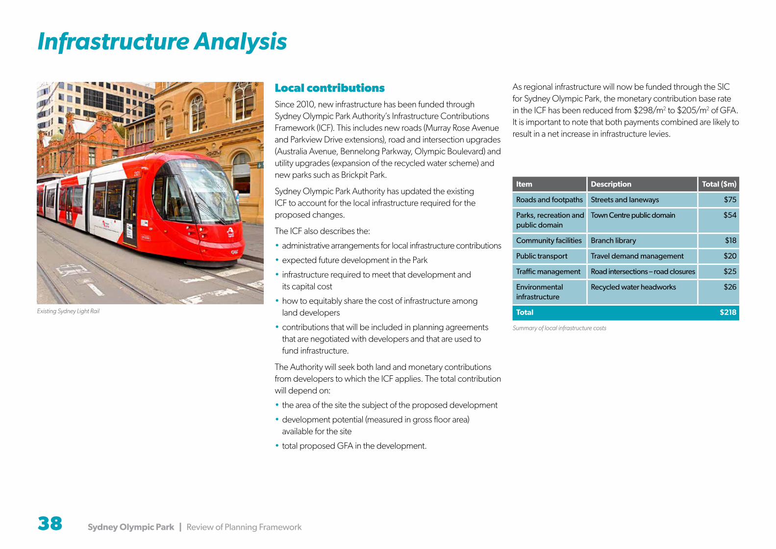
38 Sydney Olympic Park | Review of Planning Framework
Infrastructure Analysis
Local contributionsSince 2010, new infrastructure has been funded through Sydney Olympic Park Authority’s Infrastructure Contributions Framework (ICF). This includes new roads (Murray Rose Avenue and Parkview Drive extensions), road and intersection upgrades (Australia Avenue, Bennelong Parkway, Olympic Boulevard) and utility upgrades (expansion of the recycled water scheme) and new parks such as Brickpit Park.
Sydney Olympic Park Authority has updated the existing ICF to account for the local infrastructure required for the proposed changes.
The ICF also describes the:
• administrative arrangements for local infrastructure contributions
• expected future development in the Park
• infrastructure required to meet that development and its capital cost
• how to equitably share the cost of infrastructure among land developers
• contributions that will be included in planning agreements that are negotiated with developers and that are used to fund infrastructure.
The Authority will seek both land and monetary contributions from developers to which the ICF applies. The total contribution will depend on:
• the area of the site the subject of the proposed development
• development potential (measured in gross floor area) available for the site
• total proposed GFA in the development.
As regional infrastructure will now be funded through the SIC for Sydney Olympic Park, the monetary contribution base rate in the ICF has been reduced from $298/m2 to $205/m2 of GFA. It is important to note that both payments combined are likely to result in a net increase in infrastructure levies.
Item Description Total ($m)
Roads and footpaths Streets and laneways $75
Parks, recreation and public domain
Town Centre public domain $54
Community facilities Branch library $18
Public transport Travel demand management $20
Traffic management Road intersections – road closures $25
Environmental infrastructure
Recycled water headworks $26
Total $218
Summary of local infrastructure costs
Existing Sydney Light Rail

Sydney Olympic Park | Review of Planning Framework 39
Supporting Documents
The review has been based on extensive planning and design work. The outcomes of the key supporting documents are described below.
Feasibility and Market Testing
Sydney Olympic Park Master Plan 2030 5 Year Review: Feasibility & Market Testing
HillPDA undertook development feasibility testing and land use demand forecasting for the Town Centre. The study considered some of the recommendations of precinct activation research prepared for Sydney Olympic Park, which focussed on increasing the uses and activation of the town centre. Key market findings indicate (at this point
in time), a growing demand for residential development and a corresponding decline in demand for new commercial office space. Retail expenditure modelling also indicated a significant growth in demand for retail in the Town Centre.
One key concern in the research is the market potential for residential development to “crowd-out” commercial uses. The review addresses this by nominating a commercial core in the Town Centre that is exclusively for commercial uses. An expanded shopping/entertainment centre is expected to improve the prospect of attracting more office space, as the Town Centre becomes more active.
The revised master plan provides increased capacity for residential and retail and recognises a reduced take up of commercial floor space. The commercial capacity remains well above current forecast demand, but it is suggested that even with increases relating to Parramatta Light Rail, the expanding educational demand and retail growth, the Park would retain adequate commercial land in the long term.
Traffic and Transport Strategy
Sydney Olympic Park Authority
Sydney Olympic Park Master Plan 2030(2016 Review)
Traffic and Transport Strategy (2016 Review)5 July 2016
As part of the review, a high level traffic and transport assessment was undertaken by WSP Parsons Brinckerhoff. The assessment considered the impact of the additional floor space proposed by the review in terms of traffic generation, performance of roads and intersections, parking, public transport usage and travel demand management within and outside of the Town Centre.
Based on the analysis undertaken, the additional traffic impacts of the proposed changes are anticipated to be manageable, subject to the implementation of a number of initiatives and recommendations including road and intersection upgrades, reducing car usage and increasing the use of public transport. The master plan provides mechanisms to help achieve these changes.
Community Facilities Strategy
Community Facilities Strategy for Sydney Olympic Park Master Plan 2030 (2016 Review)
Client: Sydney Olympic Park Authority
Date: 9 June 2016
Draft
Elton Consulting prepared a Community Facilities Strategy to support the review. The strategy considered the likely needs and demands for community infrastructure based on revised population forecasts for the Town Centre and the likely demographic characteristics of the future residential and workforce populations.
The Strategy identified the need for new community infrastructure such as new and improved open space, a library, multi-purpose community centre, child care centres and a high school. The updated master plan makes provision for these facilities.
Noise Management Guidelines
SYDNEY OLYMPIC PARK MASTER PLAN 2030 2016 REVIEW - NOISE MANAGEMENT GUIDELINES
REPORT NO. 99053-M6 VERSION E
JULY 2016
PREPARED FOR
SYDNEY OLYMPIC PARK AUTHORITY 8 AUSTRALIA AVENUE
SYDNEY OLYMPIC PARK NSW 2127
Wilkinson Murray reviewed and updated existing acoustic provisions to account for the proposed changes made by the review. The primary focus of the noise guidelines is to minimise potential acoustic impacts of sporting and entertainment venues on other land uses within and around the park.
The report found that while the Central and Parkview Precincts are
affected by noise and that residential development in these areas will require varying levels of noise mitigation (such as acoustic facades), there are no areas within either of these precincts where residential development would be unsuitable due to noise. The Stadia Precinct is dominated by ANZ Stadium activities. Given that such events will normally occur outside standard business hours, it is anticipated that there will be no substantive effect on commercial land uses, which are far less sensitive to event generated noise than other land uses.

40 Sydney Olympic Park | Review of Planning Framework
Source of Images
Page Image caption Source Front cover Sydney Olympic Park 2030 3D model Sydney Olympic Park Authority - Buildmedia
Contents Parkview visualisation Cox Richardson
1 Artist’s impression of Olympic Park 2030 Tim Throsby
2 Olympic Boulevard Cox Richardson
2 Linear park - Central Precinct Cox Richardson
2 Local park - Parkview Precinct Cox Richardson
3 ANZ Stadium Cox Richardson
3 Australia Avenue Cox Richardson
3 Future Central Precinct 3D view Sydney Olympic Park Authority - Buildmedia
7 Proposed illustrative Master Plan to 2030 Tim Throsby
9 Briefing presentations… Sydney Olympic Park Authority
9 World Café session Sydney Olympic Park Authority
9 Feedback and ideas… Sydney Olympic Park Authority
11 Mixed use high density hub Sydney Olympic Park Authority – Paolo Busato
12 Parklands surrounding the Town Centre Sydney Olympic Park Authority – Ethan Rohloff
13 Commercial buildings along Dawn Fraser Avenue Sydney Olympic Park Authority – Paul K Robbins
13 Residential towers along Australia Avenue Sydney Olympic Park Authority – Paolo Busato
13 Tom Wills Oval GWS Giants
13 Netball Central Sydney Olympic Park Authority
14 Olympic Boulevard visualisation Cox Richardson
17 Shadow study diagrams during June Cox Richardson
17 Desired future built form and design Sydney Olympic Park Authority – Buildmedia
20 Australia Avenue visualisation Cox Richardson
22 Central park visualisation Cox Richardson
24 ANZ Stadium visualisation Cox Richardson
25 Proposed built form and relationship to Carter Street Sydney Olympic Park Authority - Buildmedia
26 Parkview visualisation Cox Richardson
27 Artist’s impression of the Parkview Precinct Tim Throsby
28 Artist’s impression of the Boundary Creek and Tennis Precincts Tim Throsby
29 Artist’s impression of the Central Sports Precinct Tim Throsby
30 Artist’s impression of the Southern Sports Precinct Tim Throsby
38 Existing Sydney Light Rail iStock Images
39 Linear park Visualisation Cox Richardson
Back Cover Parkview visualisation Cox Richardson

Sydney Olympic Park | Review of Planning Framework 41