SUDG Stakeholder workshop: Agenda and Notes MPA ... · MPA Conservation Advice/SUDG stakeholder...
16
SUDG Stakeholder workshop: Agenda and Notes MPA Conservation Advice/SUDG stakeholder workshop Date 19 th July 2017 Start time 11:00 Finish time 15:00 Location Nobel House Atrium Agenda Item Description Purpose Presenter Time 1 Welcome and introductions Welcome, Health and Safety, outline purpose and objectives of meeting Joanna Redgwell 11:00 - 11:15 2 Conservation Advice Project update To provide a demonstration of the products available on .gov.uk and the interactive conservation advice packages Joanna/Redgwell/ Hilary Crane /Eddy Mayhew 11:15 - 12:15 Lunch Break 12:15 - 13:00 3 Introduction to the conservation objectives/Advice on Operations linking tool Commercialisation aspects of Pressure Feature Integrity (PFI) of Conservation Advice Eddy Mayhew 13:00 - 13:30 4 Favourable Conservation Status Project (FCS) Favourable Conservation Status Project (FCS) and alignment with conservation advice Christina Cork 13:30 - 14:15 5 AOB and close 14:15 - 14:30
Transcript of SUDG Stakeholder workshop: Agenda and Notes MPA ... · MPA Conservation Advice/SUDG stakeholder...

SUDG Stakeholder workshop: Agenda and Notes
MPA Conservation Advice/SUDG stakeholder workshop
Date 19th July 2017 Start time 11:00 Finish time 15:00
Location Nobel House Atrium
Agenda
Item Description Purpose Presenter Time
1 Welcome and
introductions
Welcome, Health
and Safety, outline
purpose and
objectives of meeting
Joanna Redgwell 11:00 - 11:15
2 Conservation Advice
Project update
To provide a demonstration of the products available on .gov.uk and the interactive conservation advice packages
Joanna/Redgwell/
Hilary Crane /Eddy
Mayhew
11:15 - 12:15
Lunch Break 12:15 - 13:00
3 Introduction to the conservation objectives/Advice on Operations linking tool
Commercialisation aspects of Pressure Feature Integrity (PFI) of Conservation Advice
Eddy Mayhew
13:00 - 13:30
4 Favourable Conservation Status Project (FCS)
Favourable Conservation Status Project (FCS) and alignment with conservation advice
Christina Cork 13:30 - 14:15
5 AOB and close 14:15 - 14:30

Attendees
Name Affiliation
Joanna Redgewell NE
Jonathan Burney NE
Caroline Cotterill NE
Christina Cork NE - FCS project
Anna Millard NE – CA Project manager
Awantha Dissanayake NE - CA National team
Eddy Mayhew NE - CA National team
Rob Enever NE - CA National team
James Highfield NE - CA National team
Joanne Ziemann NE - CA National team
Hilary Crane NE – Area Team
Chris Davis NE
Nikki Hiorns NE – Specialist
Marie Alvarez NE - Specialist
Laura Cornick JNCC
Gemma Harper Defra
Ros Gaulton/David Reeves Defra
Peter Barham SUDG
Simon Wood EDF
Peter Jamieson
Tony Fisk Pelagian International
Rosie Kelly The Crown Estate
Olivia Thomas The Crown Estate
Mick Borwell Oil and Gas Uk
Judith Shapiro CCSA Association
Brian Clark British Marine
Mark Russell Mineral Products
Steve Marshall Scottish Power
Emma Barton RYA
John Wrottesley GMSL
Sara Thomas DONG
Jan Brooke Peel Ports
Lisa Reilly Peel Ports
Louise O Hara Murray Oil and Gas
Rachel McCAll PMSS
Sian John (or someone else) RHDV
TBC ABPmer
Katherine Harris Port of Aberdeen
Louise Bridges
Tanya Ferry Port of London
Sophie Hartfield
Theresa Crossley
Alan Tinline
Rod Jones
Kiera Wilson Scottish Power
Tom Anderson
Edward Skinner
Joseph Holcroft

Bethany Graves JNCC
1. Joanna Redgwell – Welcome and opening address (See Presentation 1)
2. Hilary Crane (HC) – Presentation of utilisation of Conservation Advice in relation to hypothetical industry scenarios (See Presentation 2)
Emma Barton (EB) – What changes to Conservation advice are incorporated at Area Team level? HC – Mapping and site-specific surveys. Site knowledge is incorporated in the Supplementary Advice on Conservation Objectives (SACOs) evidenced with references and shown by pop-ups in DSS. PB – Once an activity is identified - any further information available? One of the frustrations of EIA’s is how far this provides clarity on depth of investigation rather than breadth of investigation i.e. proportionate? HC – Each EIA is case-specific; however, the Risk Profiling of Pressures (RPPs) and benchmarks certainly provide sensitivity of each underlying biotope, for example. One area which provides clarity is linking of pressures to integrity attributes in the SACO – see later in the meeting for explanation. Mark Russell – Inshore activities and features have large certainty due to evidence/offshore is where a large uncertainty exists and extent evidence is precautionary. EM – On each package, a last update timestamp provides clarity of when the evidence/component of the package was updated. Jan Brooks (JB) – What information is available in terms of close/far way to feature? HC: Expert judgement is needed here and is provided by the NE case officer. Obviously depends on the local conditions. MAGIC maps provide feature maps and where there is no information – NE case officer can help. JB - RPPs: Low risk activities are listed/captured depending on pressure, but if deemed ‘low risk’ why is there a need to consider? If it is to be considered, then not truly low risk? Therefore, a lot of work to truly understand the work/packages? MR – ‘Every application is a journey’ PB – A lot to be learned, however, CA packages in particular Advice on Operations (AoO) provides a framework. Joe Hawcroft (JH) – What are the procedures for updating the data? HC – Mapping: survey/monitoring, publically available data. Please forward any data you may have/wish to share. CA packages are updated annually. EB – What are the procedures to updating an activity and how to be questioned? HC – send queries to MCA mailbox. NE has a internal change log process; derived from international list of pressures. David Reeves – A case study video/guidance would be useful.

3. Eddy Mayhew/Chris Davis – Presentation of ‘Screening Tool’ (See Presentation 3)
Notes from NE marine conservation advice commercial proposals session Natural England has put a huge amount of effort into its conservation advice, and as a result of this we have delivered (and are continuing to deliver) a transparent, consistent and evidence-based approach to advice provision. This includes a radical overhaul of the mapping of English MPAs and the habitats that they protect, a detailed and user-focussed approach to advice on operations (including new and detailed sensitivity evidence for features likely to be affected by those operations), assessment of the likely risk of a given activity causing a pressure, and justification detail on how an activity might cause a pressure. We now provide information, where relevant, on which times of year a designated feature might be present and particularly susceptible to damage or disturbance. On top of all this, we now provide detailed supplementary advice and information to underpin the conservation objectives in the site, so that conservation objectives are in effect quantified, by feature; by describing the key targets in the site for attributes of the feature which, when taken together, constitute ‘site integrity’ – or what ‘good’ looks like. In providing this advice we having hugely improved our access to evidence via the Designated Sites System (DSS) upon which the conservation advice is now published. Users can drill down into the information used to formulate the advice, look at the surveys that provided the mapping data, look up the references used to set targets etc; and challenge where appropriate. We have, within Natural England, streamlined a complex process of producing, publishing and updating this advice, so that it can and will remain live in response to new evidence arising within a given site. All of this work has been done with a lot of detailed discussion with industry, and we have incorporated a lot of suggestions from stakeholders back into the design of the advice to ultimately greatly improve the product overall. Where are we now and what remains to do? At the start of the project to improve our marine conservation advice, our aspirations were that the new advice would:
Facilitate Nationally Significant Infrastructure Projects (NSIPs)
Improve the quality and quantity of data
Be operator-focussed
Be consistent
‘Show our workings’
Follow NE and governments standards
Improve the customer experience
Make it simple
We can clearly demonstrate progress against the majority of those original aspirations, although it could be argued that we could go further around improving the customer experience, and making the advice simple. The challenge however is the wide scope of the advice – to be multi-user, provide much-needed detail of specific issues and access to evidence for those users who need it - means that the advice can appear complicated, be time-consuming to interpret and may in many ways be overwhelming. There still exists in some ways the potential for subjectivity in interpretation, as well as the possibility of high costs for developers in consulting time. A potential solution Natural England have been looking at potential methods for automating bespoke advice for a given project or site, so that a user could quickly screen-out interactions or pressure pathways that can be demonstrated as not being damaging to the site or feature(s), based on the conservation advice available. In most cases, the main question to answer within an environmental assessment is:

Will my Activity be likely to have a Significant effect on Site Integrity? We are therefore proposing a ‘screening tool’ that essentially connects the Advice on Operations to the Supplementary Advice on Conservation Objectives. The logic behind this tool (and the possible outputs it could provide) would be that if a) the Advice on Operations can tell you which pressures an activity or activities might exert and the feature’s sensitivity to those pressures; and if b) we can define which pressures could affect which attributes (from the Conservation Objective); we should therefore be able to provide a series of outputs which predict potential effects upon site integrity. We are working on both the data that we would need to be able to provide these types of outputs, the options for what the user-focussed outputs would be, and also how the process for disseminating outputs would work, but are keen to design these products with the user groups who would ultimately be receiving and using them. Figure 1 shows how an input screen could work. The user would use the existing Advice on Operations screen to generate an output for a given activity, as a component of their proposed project. This would show, as now, the pressures that could be caused by that activity, and the evidence for the sensitivity of the designated species and habitats to those pressures, were they to interact. At this point however, the user would be able to select particular features and pressures to explore further. Figure 2 shows how, by using the other aspects of a conservation package such as mapping (i.e. likelihood of interaction), sensitivity assessments, seasonality tables etc; the user could select certain features; and in a similar way select pressures, based on the likelihood of pressures being caused, the pressure risk assessments and the sensitivity evidence.

Figure 1: An Advice on Operations output for a selected activity in a selected site
Inte
rtid
al m
ud
Inte
rtid
al r
ock
Inte
rtid
al s
and
an
d m
ud
dy
san
d
Sub
tid
al c
oar
se s
edim
ent
Sub
tid
al m
ixed
sed
imen
ts
Sub
tid
al s
and
Inte
rtid
al c
oar
se s
edim
ent
Inte
rtid
al m
ixed
sed
imen
ts
Inte
rtid
al m
ud
Inte
rtid
al s
and
an
d m
ud
dy
san
d
Abrasion/disturbance of the substrate on the surface of the seabed S S S
Changes in suspended solids (water clarity) NS* S* NS* S S S NS* S* NS* NS*
Habitat structure changes - removal of substratum (extraction) S S S IE IE
Penetration and/or disturbance of the substrate S S S
Physical change (to another seabed type) S S S
Removal of non-target species S S S S S
Siltation rate changes (Low) NS* S* S* S S S S* S* NS* S*
Water flow (tidal current) changes NS* S* S* S S S NS* NS* NS* S* NS NS
Wave exposure changes - local NS* S* S* S S S NS* S* NS* S*
Barrier to species movement S S
Collision BELOW water S S
Emergence regime changes S* S* S* S* S* S* S*
Hydrocarbon & PAH contamination. NS NS NS IE IE
Introduction or spread of non-indigenous species IE S S IE IE
Litter IE IE IE IE IE
PRESSURES
Estuaries Mudflats and sandflats not
Riv
er la
mp
rey
(Lam
pet
ra
flu
viat
ilis)
Sea
lam
pre
y (P
etro
myz
on
mar
inu
s)
Feature screening (x): Using the maps, sensitivity scores, seasonality tables and other information, select features with which the activity may interact (see fig. 2). Pressure screening (y): Using the pressure risk assessments, sensitivity scores and other information, select pressures which may be caused by the project/activity (see fig. 2) Figure 2: Selecting pressures and features from the Advice on Operations output, in relation to a project
Inte
rtid
al m
ud
Inte
rtid
al r
ock
Inte
rtid
al s
and
an
d m
ud
dy
san
d
Sub
tid
al c
oar
se s
edim
ent
Sub
tid
al m
ixed
sed
imen
ts
Sub
tid
al s
and
Inte
rtid
al c
oar
se s
edim
ent
Inte
rtid
al m
ixed
sed
imen
ts
Inte
rtid
al m
ud
Inte
rtid
al s
and
an
d m
ud
dy
san
d
Abrasion/disturbance of the substrate on the surface of the seabed S S S
Changes in suspended solids (water clarity) NS* S* NS* S S S NS* S* NS* NS*
Habitat structure changes - removal of substratum (extraction) S S S IE IE
Penetration and/or disturbance of the substrate S S S
Physical change (to another seabed type) S S S
Removal of non-target species S S S S S
Siltation rate changes (Low) NS* S* S* S S S S* S* NS* S*
Water flow (tidal current) changes NS* S* S* S S S NS* NS* NS* S* NS NS
Wave exposure changes - local NS* S* S* S S S NS* S* NS* S*
Barrier to species movement S S
Collision BELOW water S S
Emergence regime changes S* S* S* S* S* S* S*
Hydrocarbon & PAH contamination. NS NS NS IE IE
Introduction or spread of non-indigenous species IE S S IE IE
Litter IE IE IE IE IE
PRESSURES
Estauries Mudflats and sandflats not
Riv
er la
mp
rey
(Lam
pet
ra
flu
viat
ilis)
Sea
lam
pre
y (P
etro
myz
on
mar
inu
s)
The cells in red in figure 2 show that the user has selected the sub-features Subtidal mixed sediment, Subtidal sand, River lamprey and Sea lamprey; as well as all of the 9 moderate to high risk pressures caused by the activity (ie the pressures shown in pink).

By doing this, the user has focussed down from 176 potential interactions to test against Likely Significant Effect, to 36. Figure 3: Selected pressures and features, in relation to a project
This output (fig. 3) shows that there are still interactions for which the feature being impacted has some sensitivity to the selected pressures, so it looks like we need to go through to the next stage of the assessment. Is my Activity likely to have a Significant effect on site integrity?
Abrasion/disturbance of the substrate on the surface of the seabed S S
Changes in suspended solids (water clarity) S S
Habitat structure changes - removal of substratum (extraction)S S IE IE
Penetration and/or disturbance of the substrate S S
Physical change (to another seabed type) S S
Removal of non-target species S S S S
Siltation rate changes (Low)S S
Water flow (tidal current) changes S S NS NS
Wave exposure changes - local S S
PRESSURES
Riv
er la
mp
rey
(Lam
pet
ra
flu
viat
ilis)
Sea
lam
pre
y (P
etro
myz
on
mar
inu
s)
Sub
tid
al m
ixed
sed
imen
ts
Sub
tid
al s
and
tLSE?

Figure 4: All features designated within the site and their attributes. NB - Grey cells indicate that the feature above has the attribute to the left. A red cell indicates that the feature above has the attribute at the left AND that attribute will be likely to be affected by the pressures selected in Figure 3.
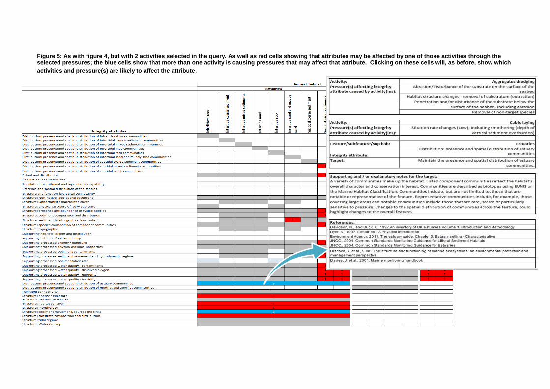
Figure 5: As with figure 4, but with 2 activities selected in the query. As well as red cells showing that attributes may be affected by one of those activities through the selected pressures; the blue cells show that more than one activity is causing pressures that may affect that attribute. Clicking on these cells will, as before, show which
activities and pressure(s) are likely to affect the attribute.
Which integrity attributes? The next step in an assessment might be to then test whether any of these pressures selected might impact upon the attributes (and targets) for the features with which there may be an interaction – perhaps as part of a Habitats Regulation Assessment. Figure 4 and Figure 5 shows how this could work across an entire site for a single activity and a multiple activity respectively. In this example the user would see a screen showing all the features (at the top) and all the attributes that apply within the site (on the left of the screen). Grey cells here indicate whether the Feature above has the attribute at the left. Importantly, the cells in red show where the feature (above) has the attribute (left) AND it could be affected by the pressures selected in the user input screen (Figure 1 and 2). This could be a good, quick, way to look across a site, and the number of ‘flags’ of potential routes by which site integrity could be affected by the activity in question, and therefore give an idea to the user about which areas need to be further examined in more detail, if at all. The intention with this view would be that each cell highlighted would give access to a pop-up showing more information on things like, pressure-risk, activity/pressure justification Multiple activities If useful and thought necessary, we are also proposing to build the same extra functionality, but for multiple activities. The idea for this would be that a user could select multiple activities and then run the same query on features and pressures in the site, in order to derive an output matrix that would indicate whether there are multiple activities likely to give rise to pressures (through any route) which may affect the attributes shown in the output screen. This might be useful in running assessments of potential incombination impacts on the same integrity attribute. Screening output The third output we propose, based on this same query, would be a flat table output/export (either as a CSV or Excel file) –see figure 6 - that would list the selected Activity, selected Pressures, Pressure-Risk profile, high-level Sensitivity, and affected Attribute (feature-specific); as a long list. The idea is that this table would be useful for those projects where a more detailed impact assessment might need to be carried out for scoped pressure interactions. Each field in the table could be hyperlinked back to the relevant information on the DSS, so that the rows in the table could be quickly assessed and potentially screened out in assessment of the project in question. This would be a quick and easy way to ultimately answer the main question of ‘Would my Activity be likely to affect Site Integrity?’ – and, if so; by which pathway?

Figure 6: A flat table exported output for a selected site, activity, and set of pressures; showing features, Risk pressure profile of selected pressures in relation to the selected activity, high-level sensitivity to those pressures, and potentially affected attributes. We would look to build into this the ability to click on cells here to be able to quickly access more detailed information held on the DSS for those data fields, e.g. attribute targets and supporting notes within the site, or detail sensitivity evidence under the high level sensitivity score shown here. Site name Haisborough, Hammond, Winterton
Selected pressures caused by the activity (subset selected by the user)Abrasion/disturbance of the substrate on the surface of the seabed
Emergence regime changes – local, including tidal level change considerations
Habitat structure changes - removal of substratum (extraction)
Introduction or spread of non-indigenous species
Penetration and/or disturbance of the substrate below the surface of the seabed, including abrasion
Siltation rate changes (High/Low), including smothering (depth of vertical sediment overburden)
Activity
Sensitive feature and
associated subfeatures
(selected in 1st matrix?)
Pressure (potential impact
identified) (selected in 1st
matrix?)
Risk Profile of
Pressure Sensitivity
Integrity attribute which could
be affected by the pressure Assessment Likely significant effect
Aggregates extractionSandbanks which are slightly covered by seawater all the time
Abrasion/disturbance of the
substrate on the surface of the
seabed Medium-High Risk H-L Extent and distribution
Aggregates extractionSandbanks which are slightly covered by seawater all the time
Abrasion/disturbance of the
substrate on the surface of the
seabed Medium-High Risk H-L
Distribution: presence and spatial
distribution of biological
communities
Aggregates extractionSandbanks which are slightly covered by seawater all the time
Abrasion/disturbance of the
substrate on the surface of the
seabed Medium-High Risk H-L
Structure: species composition of
component communities
Aggregates extractionSandbanks which are slightly covered by seawater all the time
Abrasion/disturbance of the
substrate on the surface of the
seabed Medium-High Risk H-L
Structure: sediment composition
and distribution
Aggregates extractionSandbanks which are slightly covered by seawater all the time
Abrasion/disturbance of the
substrate on the surface of the
seabed Medium-High Risk H-L
Structure: non-native species and
pathogens
Aggregates extractionSandbanks which are slightly covered by seawater all the time
Abrasion/disturbance of the
substrate on the surface of the
seabed Medium-High Risk H-L
Structure and function: presence
and abundance of key structural and
influential species
Aggregates extractionSandbanks which are slightly covered by seawater all the time
Abrasion/disturbance of the
substrate on the surface of the
seabed Medium-High Risk H-L
Supporting processes: physico-
chemical properties
Aggregates extractionSandbanks which are slightly covered by seawater all the time
Abrasion/disturbance of the
substrate on the surface of the
seabed Medium-High Risk H-L
Supporting processes: water quality -
contaminants

Page 12 of 16
What would be the value in building this screening tool? As with all aspects of these proposals, we would appreciate feedback and suggestions, but our belief is that in making these tools commercially available, we could enable the rapid and timely development of assessments, both for customers and in supplying our own advice for specific projects. It could make our advice provision even more consistent around the country and across protected species and habitat. As a result, it could therefore dramatically reduce subjectivity in advice provision. By increasingly the consistency of advice and helping developers quickly narrow down to the potentially high-risk interactions (i.e. pathways in which the project/activity might affect site integrity) we could in effect reduce the risk currently inherent in the assessment process, and thereby reduce developer costs. Natural England’s Conservation Advice: future investment Natural England has made considerable investment to meet its statutory requirements and stakeholder requirements with its marine conservation advice. We want to keep our advice up to date, and continue to improve its accessibility, functionality etc; but this is in the face of significant projected funding pressures from Government. To sustain and improve this service we will need to recover ongoing costs for conservation advice (following updates). The annual cost of service is not presently known but considered to be <£100k. Future investment principles New conservation advice packages will continue to be published and freely available. Any cost recovery for the added-value products described above would be for the use and advice of the proposed screening tool – this would be a discretionary service. The service would be provided and managed by Natural England (although there could be longer term licence options). Recovery of costs would be for the annual maintenance costs of managing the service and some investment in improving the evidence base. Cost recovery options Charges for use of the service described could be based on the time it takes to undertake screening and provide advice (i.e. as an extension to existing Discretionary Advice Service); as a flat rate cost for the use of the screening tool; or a combination of both. There could also be the option of annual industry sector contributions, which could in turn reduce costs to members. Next steps Subject to funding, we would be aiming for the service to be available from April (with some pilot work done ahead of then). Welcome feedback on the cost recovery options, and would welcome further discussions with Industry Sectors / Groups if interested, on the development of the screening tool. CA hosted a webinar for internal staff – can be shared with stakeholders. PB – ‘Making information consistent’ – a big selling point, but where the consistency stops is a local judgement/but the application of it raises the question and requires more thinking. Rob Enever (RE) – ‘More internal thinking required and certainly more training of our internal staff. JB – Cost recovery thoughts – a problem agreeing scope of assessment - a long winded process. However, a tool + scope: would it be possible that no more discussions from then on i.e. guaranteeing to not slow down the process. Chris Davis (CD) – Generally agreed – yes/jointly agreed with applicant and case officer, barring exceptions i.e. risk reduction process. ‘Ports’ – We can learn lessons from National Resources Wales (NRW) cost recovery i.e. problems with small developers; cost too high. CD – So thinking required ‘what is reasonable and fair?’

Page 13 of 16
EM – Steps to take, develop the tool/pilot and refine. PB – Be very careful if screening tool i.e. it provides a framework in which is jointly agreed, for scoping; needs local involvement. JB – Hope it overcomes the ‘I forgot to include discussions…’ NH – Only covers protected sites RE – Can be extended to outside protected sites MR – Anything that reduces the involvement of the ‘Columbo effect’ (i.e. just thought of something else), industry should not bear the full cost. How does it involve the cumulative and in-combination effects? EM – this tool would answer that. JB – Is it sufficiently site-specific? E.g. Capital dredge/Windfarm/Coastal defence – all at once? MR – Then NE builds on that ‘baseline’ position. Activities that take place in a site but site-focussed but what about next to a site? EM – Yes, could be more sophisticated i.e. zone of influence Rob Jones – What about input from regulators? EM – We liaise already on joint sites in terms of sister agencies, will be shown to other SNCB’s at the CA Advisory Group (CAAG). MR – How do you assess the significance? RE –By working together with the other SNCBs and relevant authorities NE would hope that we could provide a consistent approach at a UK level which would ultimately serve industry well by delivering a single and consistent approach to advice provision across the varying administrations EM – Will be training with the MMO EM – Workshops to gauge thinking, what are your thoughts CD – April is the timeframe to have a product to test SEE BREAKOUT GROUPS notes below Group A: Facilitator - Nikki Hiorns
Q1: How useful is the new tool?
• Like the new outputs, improvement of Reg 33 etc. Improve consistency and certainty in our advice to industry. • There is still a huge amount of detail in the outputs so the proposal to develop the products further is welcome, but moving in the right direction • Wish to feedback on ‘crap FAP’ (I did explain about crap FAP and all the random combinations we have already removed) and other odd outputs from the packages as there are used to define them further. Mention of what appear to be random combinations – ABP and Peel. • Would like the mapping to be more interactive, the ability to query the map and link directly to information and/or highlight an area on a map and automatically trigger which sites and features need to be considered within a certain distance criteria. • There is still the issue with mobile species, indirect pressures to consider and the limitations of the packages need to be clear.
Q2: How involved would you like to be?
• Yes it’s a positive move, step in right direction, improvement in consistency and application of cons advice packages both by industry, SNCB and regulators. • Would like training on the packages and the new screening tool for their staff who will need to use it regularly (ABP),

Page 14 of 16
• Recognition that the initial tool will be version 1 and that there need to be the ability to refine and improve over time. • Important to build confidence in the tool outputs and it is providing the correct answers. • Will need buy in from regulators (EA, MMO, LPA, BEIS, PINS etc.) • Need to ensure transparency in the process and tool with stakeholders and NGOs, so it does not appear that industry are paying for ‘good’ answers, there need to be confidence and buy-in from NGOs in the outputs and understanding is how these are generated. However use of the screening tool with stakeholder (mtg etc) could build confidence, consistency and certainty in screening. • What is the likelihood in delivery of screening tool by April? • In-combination and cumulative assessment – the tool could add real value, especially if there was the ability to record previous screening done for sites and build upon to have a better understanding of on-going activities/current plans and projects within a sites, cumulative effects both for HRA/EIA etc, but also wider for WFD and MSFD. • Would also like the ability to link with MMO and other regulators data on licenses/on-going activities to build better picture of cumulative impacts etc. • Would like to understand more about how could be used for cross border sites, how link with other SNCBs e.g. Severn Estuary. • Would like to understand which sites this would apply too – question over southern north sea pSAC & Harbour Porpoise (think generally my group would like a clear list of which sites will have new conservation advice packages and which are unlikely too) • Query how would address mobile species, indirect effect, pressure distance from site boundaries e.g. seabirds, harbour porpoise and migratory fish. How these could be included in cumulative/in-combination effects of screening tool. • How will tool be accessed – so like idea of being able to log-in and use it. • Would like the ability to see activities/live licenses over laid with cons advice mapping e.g. MMO GI and ours to look at potential cumulative effects etc. Q3 There was appetite for being involved in pilots • Jan Brook, Peel Ports Mersey – looking at multiple activities, multiple sites and features and testing screening tool for its ability to screen across this and address in-combination etc. • Joe Green, Royal Haskoning – would be interested in look too at schemes where multiple sites , pressures and features apply. Also how would interact with terrestrial sites screening undertaken for EIA etc. • Alan, ABP – also happy look at this, many also to look at S.Wales/Severn issues and whether can use cross border. Jan/Peel – also interested in how could be used for their work in the Clyde. Group B: Facilitator – Anna Millard Accessibility Early scoping Less subjective Reduced risk of late additions during scoping exercise Seasonality, thinking about zonation
1. How useful is the new tool?
Rachel McColl (cabling) – Provides a consistent, automated template for assessments which reduces the chance of human error in ccreating templates, particularly when dealing with complex projects which may cross multiple sites and features. This represents a big time and cost saving in the initial start up of a project. Provides a base assessment for joint scoping which reduces the iterative process currently in place at the screening stage. Costings unknown for industry here, cost-benefit analysis of time saved would need to be calculated to balance benefits of charged model
Page 15 of 16
Different users use information for different purposes eg RYA very specific looking at signpost location etc. RYA members need advice but can least afford it eg. Club works to slipways, would smaller works be cheaper? Cumulative effect could be to get all systems to “talk” to each other through eg the Crown Estate/MMO planning portal The consistency of the new tool is good but concerns raised over too much interpretation of advice by local case officers (point already raised and responded to earlier in day).
2. How involved would you like to be?
Users are keen to be involved in development of next phase There is a definite role for sector leads to continue to be involved in developing the tools, and particularly any adaptation or additions to Advice on Operations There will be an inconsistency of use among members depending on which area they work in. NSIP projects are more likely to be keen due to time saving for large complex projects eg port developments, nuclear, particularly as these are projects which are more difficult to adapt and move in response to environmental sensitivities such as cabling. Updating of the system- frequent updating of databases required to maintain best available evidence standard Considered variable buy in-options Smaller projects could have a one off access code where larger industry could pay for log on access Industry and NE need to collectively decide what the end service will provide and the cost benefits of such a service to create an appropriate charging regime. Group C: Facilitator – Hilary Crane - Seasonality - thinking needed about Zonation - Charging – Different stakeholders have different purposes, therefore, scale of users. - Cumulative effects: NE need to liaise with MMO system. - Consistency good but concern over too much local case officer (over precautionary?), therefore, worst-case output.
4. Christina Cork – Favourable Condition Status (FCS) project (See Presentation 4)
Caroline Cotterill – Licencing and Planning is phase 2 of project. Christina Cork – Example of Great Crested Newt – FCS. E.g. density within range and places i.e. at county level at favourable range. FCS is a more pragmatic approach/more focussed/allows more flexibility JB – What are the implications for port operators for improved targets? Would we be disadvantaged – therefore a little worrying then. C. Cork – Project is currently in Phase 1 which does not consider implementation which is in Phase 2 of the project JB – More dialogue needed with stakeholders C. Cotterill – Will give us an idea of what ‘good’ looks like. Society then decides. JR – What is the mechanism for engagement for conversations? C. Cork – Webinars are the first port of call. To be announced shortly.

Page 16 of 16
Caroline Cotterill/Joanna Redgwell/Peter Barham – Closing remarks JR – Meeting close comments. Conservation Advice is complicated to develop, but simple to use. ‘Screening tool’ - need buy in from NGOs. On the whole a positive day. C. Cotterill – Closing remarks. How do we follow up on feedback? EM – feedback captured and shared from Peter’s website, in particular required around screening tool. C. Cotterill – Closing remarks. Fantastic development of CA evolution. Conservation 21 is NE’s new strategy. Conservation is integral and how to work people. Marine Conservation advice is a good example of that.