
Subsidence and Elevation in New Orleans · Subsidence and Elevation in New Orleans Shimon Wdowinski...
21
Subsidence and Elevation in New Orleans Subsidence and Elevation in New Orleans Shimon Wdowinski (UM) Tim Dixon (UM) Falk Amelung (UM) Sang-Wan Kim (UM) Roy Dokka (LSU) Alessandro Ferretti (TRE) Fabrizio Novali (TRE) Dean Whitman (FIU)
Transcript of Subsidence and Elevation in New Orleans · Subsidence and Elevation in New Orleans Shimon Wdowinski...

Subsidence and Elevation in New Orleans
Subsidence and Elevation in New Orleans
Shimon Wdowinski (UM)Tim Dixon (UM)
Falk Amelung (UM)Sang-Wan Kim (UM)
Roy Dokka (LSU)Alessandro Ferretti (TRE)
Fabrizio Novali (TRE)Dean Whitman (FIU)

Land loss in Louisiana
http://www.nwrc.usgs.gov/upload/landloss11X17.pdf
Land loss is mainly due to subsidence and sea level rise

Why Subsidence?
• Sediment load
• Sediment compaction
• Fluid withdrawal (water and oil production)
• Tectonics

Why Subsidence? - Tectonics
Dixon et al. (2006)
Southern Louisiana Block is sliding on a weak salt layer toward the Gulf of Mexico

Surface SubsidenceThe primary cause of this massive land loss is the alteration
of natural processes that are essential to sustaining wetlands.
http://www.lacoast.gov/watermarks/2005-08/1wetlandsDisappear/
With Floodwaters Blocked, Nutrients, Sediment No Longer Offset Subsidence
• Levee construction for flood protection
• Creation of navigation channels, and canals for oil and gas exploration and production.

Sea Level from Multiple Atlimetry & Tide Gauge (1900-2002)
(C.K. Shum, 2006)

Space-based monitoring of surface movements
Space-based monitoring of surface movements
The techniques: PSInSARPermanent Scatterers
Interferometric Synthetic Aperture Radar (SAR)
The techniques: PSInSARPermanent Scatterers
Interferometric Synthetic Aperture Radar (SAR)
(InSAR)

Synthetic Aperture Radar (SAR)Synthetic Aperture Radar (SAR)
RADAR remote sensing is an `active` imaging technique that utilises the microwave region (~1-100 cm) of the EM spectrum
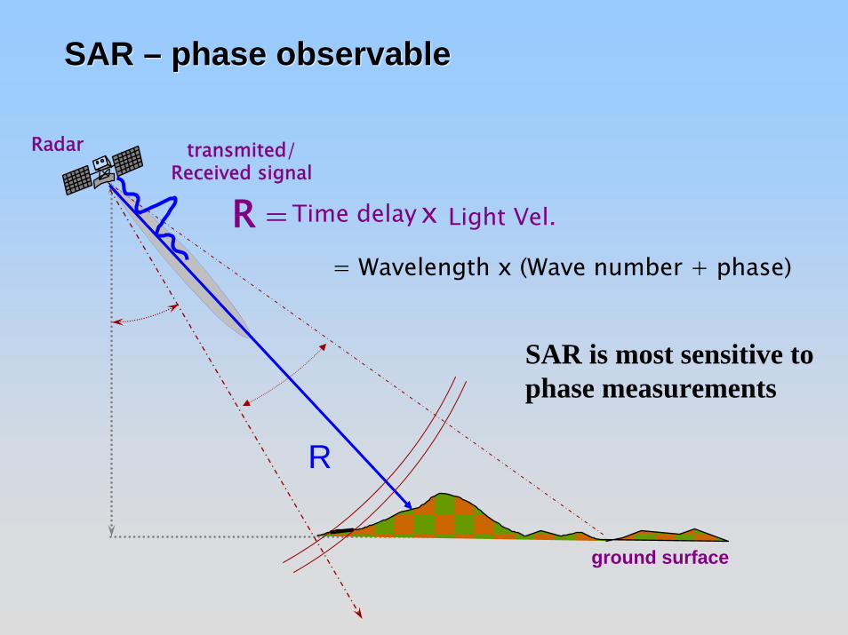
SAR – phase observableSAR – phase observable
R
ground surface
Radar
R Light Vel.Time delay x=
transmited/Received signal
= Wavelength x (Wave number + phase)
SAR is most sensitive to phase measurements

Interferometric SAR - InSAR
Two or more data acquisition of the same area from nearby location (< 1000 m)
Changes in surface location result in detectable phase changes
Fringes – 1 cycle (2π) = ½ λ

Surface or Atmospheric changes in LouisianaOver 48 days (2005/02/03-2005/03/01)

Permanent Scatterer InSAR: PS InSARPermanent Scatterer InSAR: PS InSAR
• Analyzing large number of SAR scenes (> 20).• Using a sub-set of the data – Only pixels with strong and
consistent reflections in time.• Multi-pass InSAR – time series necessary.
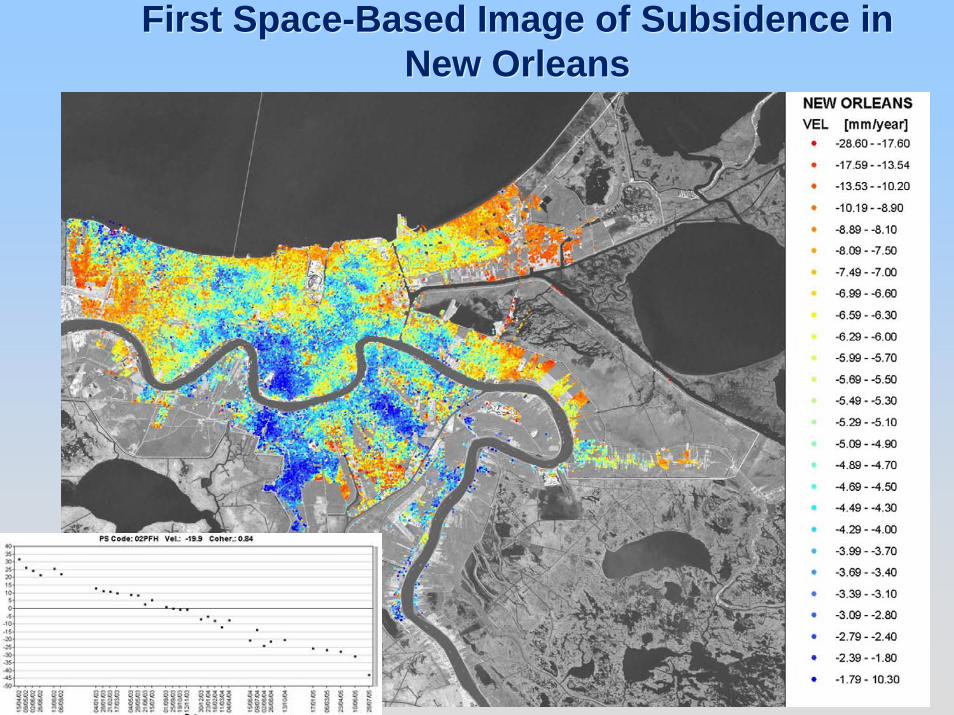
First Space-Based Image of Subsidence in New Orleans
First Space-Based Image of Subsidence in New Orleans


Distribution of SubsidenceDistribution of Subsidence• Approximately 180,000 scatterers• Mean subsidence rate is 6±2 mm/yr• Large range of heights (10’s of m above ground
elevation) implies building tops are important radar reflectors
• High elevation scatterers subside at same rate as low elevations, implying building mass does not contribute to subsidence (importance of deep pilings; building codes work!)
• Tail of extremely high subsidence rates (20-30 mm/yr) in a few locations; these tend to be located in recently drained marshes (eg Kenner) or levees (large surface mass, no pilings)

St. Bernards Parish: Levee system post Katrina damage assessment St. Bernards Parish: Levee system post Katrina damage assessment
Source: http://www.freerepublic.com/focus/f-news/1489838/posts
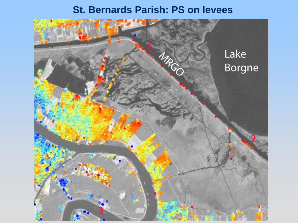
St. Bernards Parish: PS on levees

Factors Contributing to Levee Failure; Implications for Rebuilding
Factors Contributing to Levee Failure; Implications for Rebuilding
• Levees adjacent to MRGO canal failed; these had high subsidence rates (>20 mm/yr)
• Levee failure may have been due height loss associated with subsidence (loading of weak marsh substrate by levee and consequent overtopping); or due to erosion of weak substrate by undercutting (in this case high subsidence rates were merely an indicator, not the cause, of failure)
• New levees will be built to withstand Cat 3 hurricanes; some levee failure is likely in case of Cat 5 due to storm surge
• Global warming is leading to ocean warming, and an increase in number and severity of tropical storms
• Cat 5 hurricanes are likely to hit New Orleans in the next few decades
• This implies that low lying areas will be flooded again in the future; rebuilding needs to take this into account

ConclusionsConclusions• Planned levees will not protect against Cat 5 storms;
these are increasing in number as the ocean warms• Rebuilding efforts should focus on areas that are higher
than 2.5-3.0 meters below sea level; lower areas will flood again, and will have high death tolls due to drowning.
• As part of the rebuilding process, citizens/authorities need to find ways to raise the elevation of the low-lying areas, or elevate the buildings.
• Only a small fraction of New Orleans is lower than 3 m below sea level (severe danger zone); in the long run it will be cheaper to give housing credits to those displaced from these areas, allowing them to rebuild on higher ground, allowing low-lying areas to revert to wetlands.
• Planner should also take into consideration the continuous subsidence (6 mm/yr) and rising sea level (~2 mm/yr).

Other disaster-prone areas along the Gulf Coast
Other disaster-prone areas along the Gulf Coast
• Tremendous devastation occurred along the coast mainly to beach-front property. Most houses were destroyed by the hurricane winds and storm surge last year (Katrina), as well as, 36 years ago (Camille).
• Orrin Pilkey (Duke) suggested to not rebuild houses for the third time in three decades. Instead, he suggested to replace the first several rows of houses with a long, artificial dune going the length of the Gulf coast. The artificial dune would offer some protection, make the beachfront much more pleasant, and aid the tourist industry.


![Study of land subsidence around the city of Shirazscientiairanica.sharif.edu/article_2167_b3bb54f3fcf13e2c...tectonic subsidence, and etc. [2]. Land subsidence, as a serious crisis,](https://static.fdocuments.net/doc/165x107/5f81603bf7f7323e190f6f7c/study-of-land-subsidence-around-the-city-of-s-tectonic-subsidence-and-etc.jpg)