Submittal - opkansas.org · STOP 2 1 5 3 4 9 10 11 12 6 7 8 1 Overall Site Plan scale: 1" = 100'-0"...
19
STOP 2 1 5 3 4 9 10 11 12 6 7 8 1 Overall Site Plan scale: 1" = 100'-0" north A1.0 10.24.2018 DAE DAE a redevelopment for 95Metcalf South Southeast corner of 95th & Metcalf Overland Park, Kansas Revised PDP 18242 Applicant Submittal
Transcript of Submittal - opkansas.org · STOP 2 1 5 3 4 9 10 11 12 6 7 8 1 Overall Site Plan scale: 1" = 100'-0"...

ST
OP
2
1
5
3
4
9
10
11
12
6
7
8
1
Overall Site Plan
scale: 1" = 100'-0"
north
A1.0
10.24.2018
DAE
DAE
a redevelopm
ent for
95M
etcalf S
outh
Southeast corner of 95th &
M
etcalf
Overland P
ark, K
ansas
Revised PDP
18242
Applicant Submittal

STOP
2
1
5
3
4
9
10
11
12
6
7
8
1
2
2
3
3
3
4
4
4
4
5
5
5
6
6
6
6
6
7
7
7
7
8
8
8
8
9
9
9
9
99
10
1010
10
11
12
12
12
13
14
15
15
16
16
16
1718
18
19
20
21
21
21
22
22
23
24
24
24
24
25
26
27
27
28
28
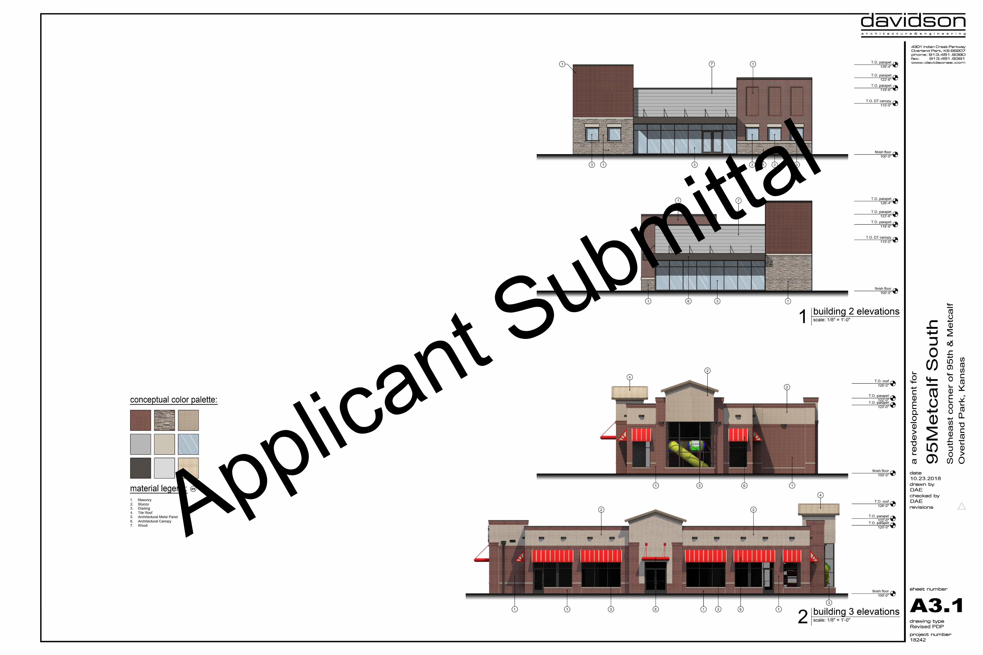
Project Synopsis
Governing Municipality: Overland Park, KansasGoverning Code: 2012 IBCZoning: CP-2, MXDCP-2 Zoning Area: 851,251 sq. ft., 19.54 acresMXD Zoning Area: 516,563 sq. ft., 11.86 acresOccupancy: Mix of A-2 (restaurant), M (mercantile), B (office), &
(R-2)ResidentialSite Area: 1,367,814 sq. ft., 31.40 acresExist. Impervious Area: 1,243,911 sq. ft., 91% coverageExist. Green Space: 123,903 sq. ft., 9% coverageProp. Impervious Area: 1,096,499 sq. ft., 80% coverageProp. Green Space: 271,315 sq. ft., 20% coverageExist. Building Area: 597,699 sq. ft.Prop. Building Area: 697,848 sq. ft.Floor Area Ratio: 24%Parking Required: 1,479 spacesParking Provided: 1,585 spaces
General Notes
All construction shall conform to the standards and specifications of thecity of Overland Park, Kansas.The general contractor shall contact all utility companies prior to the startof construction and verify the location and depth of any utilities that maybe encountered during construction.The general contractor shall field verify existing surface and subsurfaceground conditions prior to the start of construction.Slopes shall maintain a maximum 3 : 1 slope for construction.The general contractor shall be responsible for obtaining all requiredpermits, paying all fees and otherwise complying with all applicableregulations governing the project.Place silt fence as required for erosion control.Property owner will provide inspections of the private storm sewer systemper the city of Overland Park stormwater management plan.All existing conditions per survey provided by owner.All site and building mounted signage requires a separate permit.A Knox Box will be installed on the front of the building facing the streetor road.All private utilities to service this site are to be placed underground.All above ground termination points to be screened from view withappropriate landscaping or painted to match primary adjacent wall color.
Construction Notes1. Exist. bus stop to remain.2. Exist. sidewalk within public right-of-way to remain.3. Provide new conc. pedestrian sidewalk to meet OP site design requirements
for width. 4" thick w/ 6x6 10/10 w.w.f. steel mesh reinf. Control joints @ 5'-0"o.c. Broom finish for non-slip surface.
4. Asphalt & conc. parking lot paving & curbs to meet city of Overland Park, KSconstruction standards.
5. Parking lot striping shall be white w/ 4" stroke.6. Provide ADA accessible ramps in sidewalk for pedestrian access to buildings
& public way.7. Provide herringbone brick patterned, integrally colored stamped conc.
crosswalk with ADA accessible ramps ea. side.8. Bicycle racks to be installed w/ ea. pad site. Final location per FDP
submission.9. Final ADA space design per individual building FDP submissions.10. Maintain existing vehicular access points along Metcalf Ave. and 95th Street.11. Exist. shopping center identification monument to remain.12. Exist. internal drives to remain.13. Exist. building and site improvements for Lot 1 to remain.14. Previously approved improvements for Lot 4 to remain.15. Reconfigure internal drive to connect at a perpendicular with updated drive on
##Previously approved improvements for Lot 4 to remain.
15. Reconfigure internal drive to connect at a perpendicular with updated drive oneast side of development.
16. Drive thru stacking and configuration to meet OP site design guidelines perFDP submission of individual lot.
17. Existing pedestrian crossing to remain.18. Parking along internal drive for multi-family development of lot 9.19. Interior amenity area withing multi-family development of lot 9.20.Public park along southern edge of 95Metcalf South.21.Pedestrian and vehicular access points shown in coordination with adjacent
development to the south.22.Covered parking for lot 10 use.23.Fire land around east side of lot 10 to remain west of exist. fence.24.Final trash enclosure location and design per FDP submissions.25.Retaining wall along west side of building 11 to be determined per FDP
submission.26.Convenience store building & canopy location per FDP submission.27.Dashed line represents limits of MXD zoning request.28. Amenity package for lot 10 per FDP submission.
Data Table
Building # Building Type Site Area Building Area Parking Provided Parking Ratio Seats Allowed Residential Units Stories
1 (CP-2) Commercial 468,587 s.f., 10.76 ac. 165,000 s.f. 376 spaces 2.3 : 1,000 - - One
2 (CP-2) Commercial 25,111 s.f., 0.58 ac. 3,500 s.f. 31 spaces 8.9 : 1,000 - - One
3 (CP-2) Restaurant 49,030 s.f., 1.13 ac. 4,600 s.f. 84 spaces 18.3 : 1,000 252 - One
4 (CP-2) Restaurant 27,976 s.f., 0.64 ac. 1,998 s.f. 32 spaces 16.0 : 1,000 96 - One
5 (CP-2) Restaurant 27,350 s.f., 0.63 ac. 2,500 s.f. 24 spaces 9.6 : 1,000 72 - One
6 (MXD) Restaurant 54,363 s.f., 1.25 ac. 6,000 s.f. 123 spaces 20.5 : 1,000 369 - One
7 (MXD) Restaurant 32,137 s.f., 0.74 ac. 4,550 s.f. 46 spaces 10.0 : 1,000 138 - One
8 (MXD) Restaurant 56,335 s.f., 1.29 ac. 5,900 s.f. 123 spaces 20.8 : 1,000 369 - One
11 (CP-2) Commercial 72,710 s.f., 1.67 ac. 25,200 s.f. 114 spaces 4.5 : 1,000 - - Two
12 (CP-2) Commercial 66,385 s.f., 1.52 ac. 4,840 s.f. 73 spaces 15.1 : 1,000 - - One
Commercial Total 879,984 s.f., 20.21 ac. 224,088 s.f. 1,018 spaces 4.5 : 1,000 1,296 seats - -
9 (MXD) Residential 116,365 s.f., 2.67 ac. 358,215 s.f. 396 spaces (381 required) - 235 units, 329 br Five
10 (MXD) Residential 165,374 s.f., 3.79 ac. 115,545 s.f. 177 spaces (202 required) - 134 units, 158 br Three
Residential Total 281,739 s.f., 6.46 ac. 473,760 s.f. 567 spaces (583 required) - 369 units, 487 br -
Park Public Amenity 33,630 s.f., 0.77 ac. - - - - - -
Street Grid Public Amenity 172,459 s.f., 3.96 ac. - - - - - -
Overall Total 1,367,814 s.f., 31.4 ac. 697,848 s.f. 1,585 spaces 2.27 : 1,000 1,296 seats 369 units -
CP-2 Description:
A tract of land being a portion of Lot 1, Metcalf South Shopping Center; all of Lot 1 and portionof Tract A, 95Metcalf – First Plat; part of Tract B, 95Metcalf – Second Plat; all ofLot 4, 95Metcalf – Third Plat, AND part of the Northwest Quarter ofSection 5, Township 13 South, Range 25 East of the 6th Principle Meridian, Overland Park,Johnson County, Kansas all being more particularly described as follows:COMMENCING at the Northwest corner of said Section 5; thence North 87°34'07" East, alongthe North line of said Northwest Quarter, a distance of 100.00 feet to the intersection of theEasterly line of Metcalf Avenue (US Highway 169) as now exists with the North line of saidNorthwest Quarter; thence South 02°25’41” East, along said East line a distance of 55.00 tothe intersection of the South line of 95th Street, as now exists, with the East line of saidMetcalf Avenue, said point being the POINT OF BEGINNING; thenceNorth 87°34'07" East, along the South line of said 95th Street, a distance of 1223.44 feet tothe West line of Block 40, Nall Hills, said line being the East line of the Northwest Quarter ofthe Northwest Quarter of said Section 5; thence South 02°24’40” East, along the West line ofsaid Nall Hills, a distance of 598.12 feet; thence South 87°34’11” West, a distanceof 267.17 feet; thence South 02°25’49” East, a distance of 96.82 feet to a point ofcurvature; thence Southerly and Southwesterly along a curve to the right, said curve having aRadius of 50.00 feet, Delta of 45°00’00” for an Arc Length of 39.27 feet to a point oftangency; thence South 42°34’11” West, a distance of 101.51 feet; thenceNorth 47°25’48” West, a distance of 101.51 feet to a point of curvature; thence Northwesterlyand Westerly along a curve to the left, said Curve having a radius of 50.00 feet, Deltaof 45°00’01” for an Arc Length of 39.27 feet to a point of tangency; thenceSouth 87°34’11 West, a distance of 762.54 feet to a point on the Easterly line of said MetcalfAvenue; thence North 02°25’41” West, a distance of 715.63 feet to the POINT OFBEGINNING and containing 851,531.98 square feet, more or less.MXD Description:
A tract of land being a portion of Tract A, 95Metcalf - First Plat; a portion of Tract B, 95Metcalf- Second Plat, AND part of the Northwest Quarter of Section 5, Township 13 South, Range 25East of the 6th Principle Meridian, Overland Park, Johnson County, Kansas all being moreparticularly described as follows:COMMENCING at the Northwest corner of said Section 5; thence North 87°34'07" East, alongthe North line of said Northwest Quarter, a distance of 100.00 feet to the intersection of theEasterly line of Metcalf Avenue (US Highway 169) as now exists with the North line of saidNorthwest Quarter; thence South 02°25'41” East, along said East line a distance 770.63 feetto the POINT OF BEGINNING; thence North 87°34'11" East, departing said East line, adistance of 762.54 feet to a point of curvature; thence Easterly and Southeasterly along acurve to the right, said Curve having a radius of 50.00 feet, Delta of 45°00'01” for an ArcLength of 39.27 feet to a point of tangency; thence South 47°25'48” East, a distanceof 101.51 feet; thence North 42°34'11” East, a distance of 101.51 feet to a point ofcurvature; thence Northeasterly and Northerly along a curve to the left, said curve having aRadius of 50.00 feet, Delta of 45°00'00” for an Arc Length of 39.27 feet to a point oftangency; thence North 02°25'49” West, a distance of 96.82 feet thenceNorth 87°34'11” East, a distance of 267.17 feet to the West line of Block 40, Nall Hills, saidline being the East line of the Northwest Quarter of the Northwest Quarter of saidSection 5; thence South 02°24'40” East, along the West line of said Nall Hills, a distanceof 523.96 feet to the Northeast corner of the South 162.11 feet of the Northwest Quarter of theNorthwest Quarter of said Section 5; thence South 87°51'39” West, along the North line of theSouth 162.11 feet of said quarter-quarter, a distance of 1223.12 feet to a point on the Easterlyline of said Metcalf Avenue; thence North 02°25'41” West, a distance of 400.21 feet to thePOINT OF BEGINNING and containing 517,260.00 square feet, more or less. 1 Site Plan
scale: 1" = 60'-0" north
A1.1
10.24.2018
DAE
DAE
a r
edeve
lopm
ent fo
r
95M
etc
alf
South
South
east
corn
er
of 95th
& M
etc
alf
Ove
rland P
ark
, K
ansa
s
Revised PDP
18242
A1.2A1.3
A1.4A1.5
Applicant Submittal

ST
OP
2
1
5
3
4
70'-0"
83'-10"
32'-2"
135'-0"
16'-1"
35'-0"
108'-0"
16'-1"
12'-0"
24'-0"
16'-0"
10'-0"
115'-1"
14'-10"
56'-2"
16'-0"
24'-0"
6'-3"
10'-0"
4'-9"14'-0
"
12'-0"
126'-0"
12'-0"
24'-0"
16'-0"
10'-0"
54'-0"
8'-0"
24'-0"
18'-0"
10'-0"
12'-0"
24'-0"
16'-0"
10'-0"
81'-0"
23'-0"
14'-0" 6'-1
"
12'-0"
24'-0"
16'-0"
10'-0"
117'-0"
21'-0"
12'-0"
24'-0"
16'-0"
10'-0"
117'-0"
18'-0"
171'-0"
18'-0"
24'-0"
18'-0"
10'-0"
20'-0"
18'-0"
24'-0"
36'-0"
24'-0"
36'-0"
24'-0"
18'-0"
63'-0"
19'-1"
20'-0"
11'-5"
R
5
'
-
0
"
R
1
0
'
-
0
"
R
1
0
'
-
0
"
R
3
'
-
0
"
R
1
0
'-
0
"
R
2
9
'-
0
"
R
1
5
'-0
"
R
1
5
'
-
0
"
R
2
5
'-
0
"
R
1
0
'
-
0
"
R
1
0
'
-
0
"
R
5
'
-
0
"
R
3
'
-
0
"
R
3
'
-
0
"
R
1
5
'
-
0
"
R
3
'
-
0
"
R
3
'
-
0
"
R
5
'
-
0
"
R
3
'-
0
"
R
3
'
-
0
"
R
5
'
-
0
"
R
5
'
-
0
"
R
3
'-
0
"
R
3
'
-
0
"
R
3
'
-
0
"
57'-11"
94'-0"
38'-1"
1
Partial Site Plan
scale: 1" = 30'-0"
north
A1.2
10.24.2018
DAE
DAE
a redevelopm
ent for
95M
etcalf S
outh
Southeast corner of 95th &
M
etcalf
Overland P
ark, K
ansas
Revised PDP
18242
Applicant Submittal

11
12
94'-6"
20'-11"
42'-2"
18'-8"
40'-4"
7'-4"
105'-8"
28'-2"
28'-10"
18'-8"
39'-10"
18'-0"
18'-8"
169'-7"
5'-2"
18'-9"
30'-3"
18'-0"
11'-0"
29'-0"
92'-4"
117'-10"
13'-6"
123'-6"
22'-8"
30'-0"
18'-8"
39'-6"
17'-4"
105'-0"
121'-5"
10'-0"
108'-0"
21'-9"
30'-0"
18'-8"
33'-9"
81'-0"
12'-9"
12'-9"
24'-0"
18'-0"
15'-0"
117'-0"
12'-9"
30'-0"
18'-8"
18'-9"
135'-0"
12'-9"
15'-9"
18'-0"
29'-11"
18'-10"
15'-6"
120'-0"
177'-6"
10'-0"
62'-0"
48'-2"
180'-5"
18'-0"
117'-8"
17'-10"
31'-0"
18'-0"
17'-6"
17'-6"
18'-0"
24'-0"
36'-0"
24'-0"
18'-0"
10'-0"
18'-0"
12'-0"
583'-9"
76'-6"
6'-2"
30'-6"
18'-0"
22'-5"
126'-0"
24'-8"
24'-0"
36'-0"
24'-0"
18'-0"
10'-0"
18'-0"
6'-0"
81'-0"
29'-6"
18'-0"
12'-0"
37'-0"
R
3
'
-
0
"
R
5
'
-
0
"
R
3
'
-
0
"
R
5
'
-
0
"
R
5
'
-
0
"
R
5
'-
0
"
R
1
0
'
-
0
"
R
5
'
-
0
"
R
3
'
-
0
"
R
5
'
-
0
"
R
3
'
-
0
"
R
3
'
-
0
"
R
5
'
-
0
"
R
3
'
-
0
"
R
1
0
'
-
0
"
R
3
'-
0
"
R
1
0
'
-
0
"
R
3
'
-
0
"
R
5
'
-
0
"
R
1
0
'
-
0
" R
3
'
-
0
"
R
1
0
'
-
0
"
R
2
'
-
9
"
12'-0"
24'-0"
1
Partial Site Plan
scale: 1" = 30'-0"
north
A1.3
10.24.2018
DAE
DAE
a redevelopm
ent for
95M
etcalf S
outh
Southeast corner of 95th &
M
etcalf
Overland P
ark, K
ansas
Revised PDP
18242
Applicant Submittal

10
117'-0"
12'-9"
30'-0"
18'-8"
18'-9"
135'-0"
12'-9"
15'-9"
135'-0"
12'-9"
30'-0"
18'-8"
39'-0"
15'-9"
162'-0"
22'-5"
20'-0"
30'-10"
15'-9"
18'-0"
10'-0"
18'-0"
12'-0"
18'-0"
10'-0"
18'-0"
29'-6"
18'-0"
12'-0"
R
3
'
-
0
"
R
5
'-
0
"
R
1
0
'
-
0
"
152'-6"
67'-0"
21'-6"
347'-6"
77'-6"
98'-11"
12'-0"
36'-0"
24'-0"
18'-0"
7'-0"
7'-0"
18'-0"
24'-0"
18'-0"
6'-1"
24'-0"
36'-0"
24'-0"
18'-0"
8'-11"
54'-0"
45'-0"
52'-0"
27'-2"
12'-4"
45'-0"
15'-0"
24'-0"
6'-2" 16'-0
"
18'-0"
36'-0"
24'-0"
18'-0"
10'-0"
24'-0"
18'-0"
7'-0"
162'-0"
16'-7"
20'-0"
30'-2"
26'-7"
24'-0"
36'-0"
24'-0"
18'-0"
243'-0"
43'-7"
20'-0"
30'-7"
198'-0"
10'-3"
24'-0"
23'-4"
18'-3"
8'-0"
24'-0"
18'-0"
64'-2"
25'-11"
126'-0"
18'-3"
24'-0"
18'-0"
5'-9"
24'-2"
18'-0"
7'-0"
10'-0"
20'-0"
30'-7"
R
3
'
-
0
"
R
5
'
-
0
"
R
5
'
-
0
"
R
3
'
-
0
"
R
1
0
'
-
0
"
R
5
'
-
0
"
R
3
'-
0
"
R
3
'
-
1
"
R
1
9
'
-
4
"
R
5
'-
0
"
R
3
'
-
0
"
R
1
5
'-
0
"
R
2
5
'-
0
"
R
3
'
-
0
"
R
1
0
'-
0
"
R
2
0
'
-
0
"
R
1
5
'
-
0
"
R
5
'
-
0
"
R
4
5
'
-
0
"
R
2
5
'
-
0
"
R
5
'
-
0
"
R
3
'
-
0
"
R
5
'
-
0
"
R
3
'
-
0
"
R
1
0
'-
0
"
R3'-0"
30'-0"
19'-9"
24'-0"
89'-3"
30'-0"
3
0
'
-
0
"
1
0
'
-
0
"
R45'-0"
R
2
0
'-
0
"
R
1
0
'
-
0
"
R
35'-0"
R
6
5
'-
0
"
R
3
5
'-
0
"
R
6
5
'
-
0
"
R
10'-0"
R
2
5
'
-
0
"
R
4
9
'-
0
"
R
3
'-
0
"
280'-0"
18'-0"
23'-6"
4'-0"
6'-0"
9'-9"
R
1
5
'
-
0
"
247'-4"
6'-9"
42'-6"
92'-11"
338'-10"
1
Partial Site Plan
scale: 1" = 30'-0"
north
A1.4
10.24.2018
DAE
DAE
a redevelopm
ent for
95M
etcalf S
outh
Southeast corner of 95th &
M
etcalf
Overland P
ark, K
ansas
Revised PDP
18242
Applicant Submittal

5
9
6
7
8
280'-0"
18'-0"
23'-6"
338'-10"
57'-11"
94'-0"
38'-1"
14'-0"
10'-0"
80'-0"
108'-0"
42'-0"
14'-0" 7'-0
"
26'-0"
24'-0"
26'-0"
12'-0"
117'-0"
11'-0"
32'-11"
18'-0"
24'-0"
18'-0"
13'-7"
18'-0"
99'-0"
31'-0"
30'-0"
22'-0"
153'-0"
25'-0"
18'-0"
24'-0"
18'-0"
13'-7"
18'-0"
24'-0"
36'-0"
24'-0"
18'-0"
10'-0"
18'-0"
30'-0"
18'-0"
7'-0"
100'-0"
7'-0"
18'-0"
25'-6"
18'-0"
6'-6"
18'-0"
25'-6"
18'-0"
10'-0" 14'-0
"12'-9
"
6'-10"7'-0
"18'-0
"
30'-0"
18'-0"
10'-0"
18'-0"
24'-0"
36'-0"
24'-0"
18'-0"
13'-7"
18'-0"
24'-0"
18'-0"
15'-0"
77'-6"
90'-8"
46'-10"
63'-5"
119'-10"
104'-9"
93'-9"
208'-10"
77'-0"
270'-0"
16'-0"
23'-11"
7'-9"
27'-0"
9'-0"
162'-0"
9'-0"
144'-0"
22'-0"
16'-0"
24'-0"
18'-0"
10'-0"
72'-0"
15'-9"
14'-0"
14'-5"
54'-0"
14'-5"
14'-0"
15'-2"
36'-0"
36'-7"
23'-11"
8'-5"
15'-8"
24'-1"
28'-0"
81'-0"
25'-3"
10'-9"
62'-11"
45'-1"
54'-0"
11'-6"
24'-0"
8'-7"
11'-6"
24'-0"
28'-0"
18'-0"
24'-0"
11'-6"
108'-0"
9'-0"
162'-0"
11'-6"
23'-11"
8'-9"
10'-0"
144'-0"
9'-0"
162'-0"
11'-6"
23'-11"
9'-3"
162'-0"
9'-0"
108'-0"
11'-6"
24'-0"
18'-0"
11'-6"
24'-0"
9'-0"
135'-0"
9'-0"
162'-0"
11'-6"
24'-0"
9'-4"
162'-0"
9'-0"
135'-0"
45'-0"
R
1
0
'
-
0
"
R
3
'
-
0
"
R
1
0
'
-
0
"
R
5
'
-
0
"
R
3
'
-
0
"
R
5
'
-
0
"
R
1
0
'
-
0
"
R
1
0
'
-
0
"
R
1
0
'
-
0
"
R
1
0
'
-
0
"
R
3
'
-
0
"
R
1
0
'
-
0
"
R
3
'
-
0
"
R
3
'
-
0
"
R
3
'
-
0
"
R
2
0
'
-
0
"
R
3
4
'
-
0
"
R
1
0
'
-
0
"
R
3
'
-
0
"
R3'-0"
R
1
0
'
-
0
"
R
5
'
-
0
"
R
3
'
-
0
"
R
3
'
-
0
"
R
3
'
-
0
"
R
3
'
-
0
"
R
3
'
-
0
"
R
5
'-
0
"
R
3
'
-
0
"
R
3
'
-
0
"
R
5
'
-
0
"
R
3
'
-
0
"
R
1
0
'
-
0
"
R
1
0
'
-
0
"
1
Partial Site Plan
scale: 1" = 30'-0"
north
A1.5
10.24.2018
DAE
DAE
a redevelopm
ent for
95M
etcalf S
outh
Southeast corner of 95th &
M
etcalf
Overland P
ark, K
ansas
Revised PDP
18242
Applicant Submittal

ST
OP
2
1
5
3
4
9
10
11
12
6
7
8
1
Grid Plan
scale: 1" = 60'-0"
north
A1.6
10.24.2018
DAE
DAE
a redevelopm
ent for
95M
etcalf S
outh
Southeast corner of 95th &
M
etcalf
Overland P
ark, K
ansas
Revised PDP
18242
Applicant Submittal

ST
OP
2
1
5
3
4
9
10
11
12
6
7
8
1
MXD Regulating Plan
scale: 1" = 60'-0"
north
A1.7
10.24.2018
DAE
DAE
a redevelopm
ent for
95M
etcalf S
outh
Southeast corner of 95th &
M
etcalf
Overland P
ark, K
ansas
Revised PDP
18242
General Subzone
Center Subzone
Civic Subzone
Applicant Submittal

ST
OP
2
1
5
3
4
9
10
11
12
6
7
8
DAE
HAZ
10.24.2018
C1.1
Know what's below.
Call before you dig.
a redevelopm
ent for
95M
etcalf S
outh
Southeast corner of 95th &
M
etcalf
Overland P
ark, K
ansas
Revised PDP
18242
Applicant Submittal
AutoCAD SHX Text
BM-1
AutoCAD SHX Text
BM-2
AutoCAD SHX Text
S
AutoCAD SHX Text
S
AutoCAD SHX Text
S
AutoCAD SHX Text
S
AutoCAD SHX Text
S
AutoCAD SHX Text
S
AutoCAD SHX Text
S
AutoCAD SHX Text
S
AutoCAD SHX Text
MH
AutoCAD SHX Text
MH
AutoCAD SHX Text
MH
AutoCAD SHX Text
MH
AutoCAD SHX Text
MH
AutoCAD SHX Text
MH
AutoCAD SHX Text
K
AutoCAD SHX Text
A
AutoCAD SHX Text
N
AutoCAD SHX Text
S
AutoCAD SHX Text
A
AutoCAD SHX Text
S
AutoCAD SHX Text
CALL
AutoCAD SHX Text
ONE
AutoCAD SHX Text
0
AutoCAD SHX Text
120
AutoCAD SHX Text
60
AutoCAD SHX Text
30
AutoCAD SHX Text
1
AutoCAD SHX Text
%%UUtility Plan
AutoCAD SHX Text
1"=60'
AutoCAD SHX Text
Construction Notes: 1. Proposed future building. Proposed future building. 2. Proposed future parking garage. Proposed future parking garage. 3. Existing building to remain. Existing building to remain. 4. Proposed retaining wall. Proposed retaining wall. 5. Proposed water main extension to be coordinated with WaterOne. Proposed water main extension to be coordinated with WaterOne. 6. Proposed domestic water service line to be coordinated with WaterOne. Proposed domestic water service line to be coordinated with WaterOne. 7. Proposed sanitary service line to be coordinated with JCW.Proposed sanitary service line to be coordinated with JCW.
AutoCAD SHX Text
north
AutoCAD SHX Text
S
AutoCAD SHX Text
co
AutoCAD SHX Text
wv
AutoCAD SHX Text
M
AutoCAD SHX Text
BFP
AutoCAD SHX Text
g
AutoCAD SHX Text
T
AutoCAD SHX Text
S
AutoCAD SHX Text
C
AutoCAD SHX Text
Symbols sanitary manhole service cleanout force main release valve rectangular structure circular structure fire hydrant water valve water meter backflow preventer natural gas meter service transformer (pad mount) primary switch gear light pole cable/phone/data junction box street light pedestrian street light electric pole guy wire end section
AutoCAD SHX Text
fmv
AutoCAD SHX Text
Utility Legend existing proposed
AutoCAD SHX Text
Linetypes sanitary main sanitary service storm sewer (existing) storm sewer (solid wall, proposed) storm sewer (solid wall, proposed) storm sewer (perforated, proposed) water main water service (fire) water service (domestic) water service (irrigation) natural gas main natural gas service schematic underground primary electric underground secondary electric underground cable/phone/data underground cable/phone/data service
AutoCAD SHX Text
right of way
AutoCAD SHX Text
%%UProperty Legend
AutoCAD SHX Text
property lines
AutoCAD SHX Text
setbacks
AutoCAD SHX Text
Vertical Benchmark: Johnson County Benchmark No. 839 (2" Aluminum Berntsen Disk Stamped "BM 839". From intersection of 95th & Metcalf go S. .25 mile to intersection of 97th St & Metcalf. Monument is in SE Quadrant of Intersection Elevation: 923.19'923.19'
AutoCAD SHX Text
JCVCN
AutoCAD SHX Text
BM-1: Control point set by Surveyor Mag nail Control point set by Surveyor Mag nail N: 244396.15' E: 2261014.48' Elevation: 962.198
AutoCAD SHX Text
BM-#
AutoCAD SHX Text
Local Benchmarks:
AutoCAD SHX Text
BM-2: SE corner of the intersection of 95th and Metcalf. SE corner of the intersection of 95th and Metcalf. Top center of water sewer manhole. Elevation: 948.00'

ST
OP
2
1
5
3
4
9
10
11
12
6
7
8
DAE
HAZ
10.24.2018
C1.2
Know what's below.
Call before you dig.
a redevelopm
ent for
95M
etcalf S
outh
Southeast corner of 95th &
M
etcalf
Overland P
ark, K
ansas
Revised PDP
18242
Applicant Submittal
AutoCAD SHX Text
BM-1
AutoCAD SHX Text
BM-2
AutoCAD SHX Text
S
AutoCAD SHX Text
S
AutoCAD SHX Text
S
AutoCAD SHX Text
S
AutoCAD SHX Text
S
AutoCAD SHX Text
S
AutoCAD SHX Text
S
AutoCAD SHX Text
S
AutoCAD SHX Text
MH
AutoCAD SHX Text
MH
AutoCAD SHX Text
MH
AutoCAD SHX Text
MH
AutoCAD SHX Text
MH
AutoCAD SHX Text
MH
AutoCAD SHX Text
MH
AutoCAD SHX Text
MH
AutoCAD SHX Text
MH
AutoCAD SHX Text
MH
AutoCAD SHX Text
MH
AutoCAD SHX Text
MH
AutoCAD SHX Text
MH
AutoCAD SHX Text
MH
AutoCAD SHX Text
MH
AutoCAD SHX Text
MH
AutoCAD SHX Text
MH
AutoCAD SHX Text
MH
AutoCAD SHX Text
MH
AutoCAD SHX Text
MH
AutoCAD SHX Text
K
AutoCAD SHX Text
A
AutoCAD SHX Text
N
AutoCAD SHX Text
S
AutoCAD SHX Text
A
AutoCAD SHX Text
S
AutoCAD SHX Text
CALL
AutoCAD SHX Text
ONE
AutoCAD SHX Text
right of way
AutoCAD SHX Text
%%UProperty Legend
AutoCAD SHX Text
property lines
AutoCAD SHX Text
setbacks
AutoCAD SHX Text
Vertical Benchmark: Johnson County Benchmark No. 839 (2" Aluminum Berntsen Disk Stamped "BM 839". From intersection of 95th & Metcalf go S. .25 mile to intersection of 97th St & Metcalf. Monument is in SE Quadrant of Intersection Elevation: 923.19'923.19'
AutoCAD SHX Text
JCVCN
AutoCAD SHX Text
BM-1: Control point set by Surveyor Mag nail Control point set by Surveyor Mag nail N: 244396.15' E: 2261014.48' Elevation: 962.198
AutoCAD SHX Text
BM-#
AutoCAD SHX Text
Local Benchmarks:
AutoCAD SHX Text
BM-2: SE corner of the intersection of 95th and Metcalf. SE corner of the intersection of 95th and Metcalf. Top center of water sewer manhole. Elevation: 948.00'
AutoCAD SHX Text
0
AutoCAD SHX Text
160
AutoCAD SHX Text
80
AutoCAD SHX Text
40
AutoCAD SHX Text
1
AutoCAD SHX Text
%%UADA Accessible Path Plan
AutoCAD SHX Text
1"=80'
AutoCAD SHX Text
north
AutoCAD SHX Text
ADA Accessible Sidewalk Path

ST
OP
2
1
5
3
4
9
10
11
12
6
7
8
9
5
5
9
6
0
960
Know what's below.
Call before you dig.
DAE
HAZ
10.24.2018
C2.1
a redevelopm
ent for
95M
etcalf S
outh
Southeast corner of 95th &
M
etcalf
Overland P
ark, K
ansas
Revised PDP
18242
Applicant Submittal
AutoCAD SHX Text
S
AutoCAD SHX Text
S
AutoCAD SHX Text
S
AutoCAD SHX Text
S
AutoCAD SHX Text
S
AutoCAD SHX Text
S
AutoCAD SHX Text
S
AutoCAD SHX Text
S
AutoCAD SHX Text
MH
AutoCAD SHX Text
MH
AutoCAD SHX Text
MH
AutoCAD SHX Text
MH
AutoCAD SHX Text
MH
AutoCAD SHX Text
MH
AutoCAD SHX Text
MH
AutoCAD SHX Text
BM-1
AutoCAD SHX Text
BM-2
AutoCAD SHX Text
0
AutoCAD SHX Text
120
AutoCAD SHX Text
60
AutoCAD SHX Text
30
AutoCAD SHX Text
1
AutoCAD SHX Text
%%UGrading Plan
AutoCAD SHX Text
1"=60'
AutoCAD SHX Text
S
AutoCAD SHX Text
co
AutoCAD SHX Text
wv
AutoCAD SHX Text
M
AutoCAD SHX Text
BFP
AutoCAD SHX Text
g
AutoCAD SHX Text
T
AutoCAD SHX Text
S
AutoCAD SHX Text
C
AutoCAD SHX Text
Symbols sanitary manhole service cleanout force main release valve rectangular structure circular structure fire hydrant water valve water meter backflow preventer natural gas meter service transformer (pad mount) primary switch gear light pole cable/phone/data junction box street light pedestrian street light electric pole guy wire end section
AutoCAD SHX Text
fmv
AutoCAD SHX Text
existing minor contour
AutoCAD SHX Text
%%UGrading Legend
AutoCAD SHX Text
existing major contour
AutoCAD SHX Text
proposed minor contour
AutoCAD SHX Text
proposed major contour
AutoCAD SHX Text
K
AutoCAD SHX Text
A
AutoCAD SHX Text
N
AutoCAD SHX Text
S
AutoCAD SHX Text
A
AutoCAD SHX Text
S
AutoCAD SHX Text
CALL
AutoCAD SHX Text
ONE
AutoCAD SHX Text
north
AutoCAD SHX Text
Utility Legend existing proposed
AutoCAD SHX Text
Linetypes sanitary main sanitary service storm sewer (existing) storm sewer (solid wall, proposed) storm sewer (solid wall, proposed) storm sewer (perforated, proposed) water main water service (fire) water service (domestic) water service (irrigation) natural gas main natural gas service schematic underground primary electric underground secondary electric underground cable/phone/data underground cable/phone/data service
AutoCAD SHX Text
right of way
AutoCAD SHX Text
%%UProperty Legend
AutoCAD SHX Text
property lines
AutoCAD SHX Text
easements
AutoCAD SHX Text
setbacks
AutoCAD SHX Text
Vertical Benchmark: Johnson County Benchmark No. 839 (2" Aluminum Berntsen Disk Stamped "BM 839". From intersection of 95th & Metcalf go S. .25 mile to intersection of 97th St & Metcalf. Monument is in SE Quadrant of Intersection Elevation: 923.19'923.19'
AutoCAD SHX Text
JCVCN
AutoCAD SHX Text
BM-1: Control point set by Surveyor Mag nail Control point set by Surveyor Mag nail N: 244396.15' E: 2261014.48' Elevation: 962.198
AutoCAD SHX Text
BM-#
AutoCAD SHX Text
Local Benchmarks:
AutoCAD SHX Text
BM-2: SE corner of the intersection of 95th and Metcalf. SE corner of the intersection of 95th and Metcalf. Top center of water sewer manhole. Elevation: 948.00'

Applicant Submittal
Applicant Submittal

Applicant Submittal

Applicant Submittal

Applicant Submittal

Applicant Submittal

Applicant Submittal

Applicant Submittal