Subdivison Ordinance - Vance County
59
2004 Edition 1
Transcript of Subdivison Ordinance - Vance County
2004 Edition
1
VANCE COUNTY SUBDIVISION ORDINANCE
Adopted November 4, 1999 Amended December 3, 2001 Amended January 22, 2002
Amended June 7, 2004 (June 7, 2004 Edition Supersedes all Previous Editions)
2004 Edition
Adopted June 7, 2004
Vance County Board of Commissioners
Wilbur M. Boyd Eddie L. Wright J. Timothy Pegram Deborah F. Brown Terry E. Garrison Danny W. Wright
Tommy S. Hester, Jr.
Vance County Planning Board
Rev. Roosevelt Alston Agnes T. Harvin Tom Hannon T.R. Burgess, Sr. (Pete). Willie Henderson Phyllis Stainback
Joel Harris
Subdivision Review Committee
Agnes T. Harvin Ronald Edmonson Allan Rowland Ken Krulik Jim Thompson
Vance County Staff
Jerry L. Ayscue Ken Krulik Ronald Edmonson (Vance County Manager) (County Planner/Asst. Dir) (Dir. Planning & Development)
2
Adopted November 4, 1999
Vance County Board of Commissioners
Wilbur M. Boyd W. L. Fleming J. Timothy Pegram Wallace Edwards Terry E. Garrison Danny W. Wright
Clarence V. Knight
Vance County Planning Board
Rev. Roosevelt Alston Agnes T. Harvin Timothy Smith T.R. Burgess, Sr. (Pete). George Henderson Phyllis Stainback
Michael C. Inscoe
Subdivision Review Committee
Gene Bobbit Donald Gupton Allan Rowland John Foster Faye Guin Jim Thompson
Cliff Rogers
Vance County Staff
Jerry L. Ayscue Julie A. Reid (Vance County Manager) (Director of Planning)
Beverly Reams (Office Assistant)
3
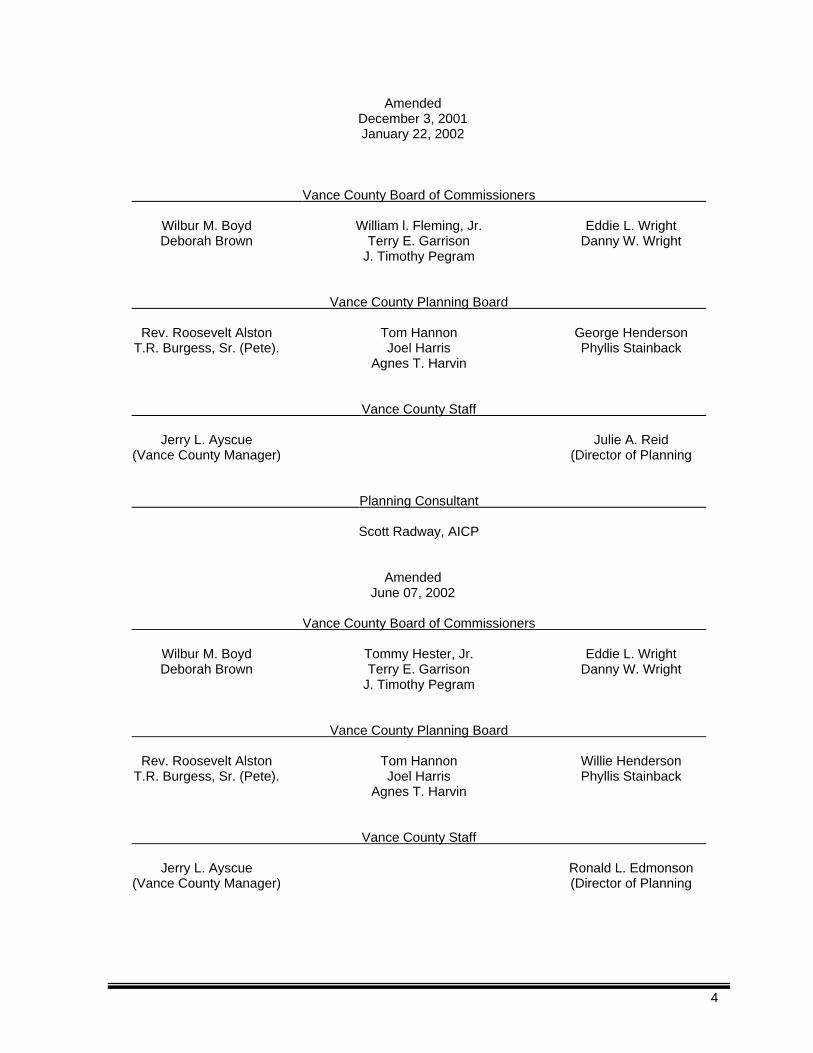
Amended December 3, 2001 January 22, 2002
Vance County Board of Commissioners
Wilbur M. Boyd William l. Fleming, Jr. Eddie L. Wright Deborah Brown Terry E. Garrison Danny W. Wright
J. Timothy Pegram
Vance County Planning Board
Rev. Roosevelt Alston Tom Hannon George Henderson T.R. Burgess, Sr. (Pete). Joel Harris Phyllis Stainback
Agnes T. Harvin
Vance County Staff
Jerry L. Ayscue Julie A. Reid (Vance County Manager) (Director of Planning
Planning Consultant Scott Radway, AICP
Amended
June 07, 2002
Vance County Board of Commissioners
Wilbur M. Boyd Tommy Hester, Jr. Eddie L. Wright Deborah Brown Terry E. Garrison Danny W. Wright
J. Timothy Pegram
Vance County Planning Board
Rev. Roosevelt Alston Tom Hannon Willie Henderson T.R. Burgess, Sr. (Pete). Joel Harris Phyllis Stainback
Agnes T. Harvin
Vance County Staff
Jerry L. Ayscue Ronald L. Edmonson (Vance County Manager) (Director of Planning
4
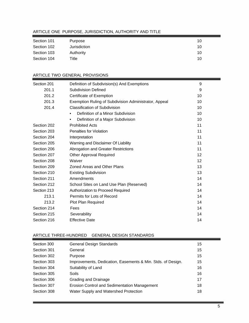
ARTICLE ONE PURPOSE, JURISDICTION, AUTHORITY AND TITLE
Section 101 Purpose 10
Section 102 Jurisdiction 10
Section 103 Authority 10
Section 104 Title 10
ARTICLE TWO GENERAL PROVISIONS
Section 201 Definition of Subdivision(s) And Exemptions 9
201.1 Subdivision Defined 9
201.2 Certificate of Exemption 10
201.3 Exemption Ruling of Subdivision Administrator, Appeal 10
201.4 Classification of Subdivision 10
• Definition of a Minor Subdivision 10
• Definition of a Major Subdivision 10
Section 202 Prohibited Acts 11
Section 203 Penalties for Violation 11
Section 204 Interpretation 11
Section 205 Warning and Disclaimer Of Liability 11
Section 206 Abrogation and Greater Restrictions 11
Section 207 Other Approval Required 12
Section 208 Waiver 12
Section 209 Zoned Areas and Other Plans 13
Section 210 Existing Subdivision 13
Section 211 Amendments 14
Section 212 School Sites on Land Use Plan (Reserved) 14
Section 213 Authorization to Proceed Required 14
213.1 Permits for Lots of Record 14
213.2 Plot Plan Required 14
Section 214 Fees 14
Section 215 Severability 14
Section 216 Effective Date 14
ARTICLE THREE-HUNDRED GENERAL DESIGN STANDARDS
Section 300 General Design Standards 15
Section 301 General 15
Section 302 Purpose 15
Section 303 Improvements, Dedication, Easements & Min. Stds. of Design. 15
Section 304 Suitability of Land 16
Section 305 Soils 16
Section 306 Grading and Drainage 17
Section 307 Erosion Control and Sedimentation Management 18
Section 308 Water Supply and Watershed Protection 18
5
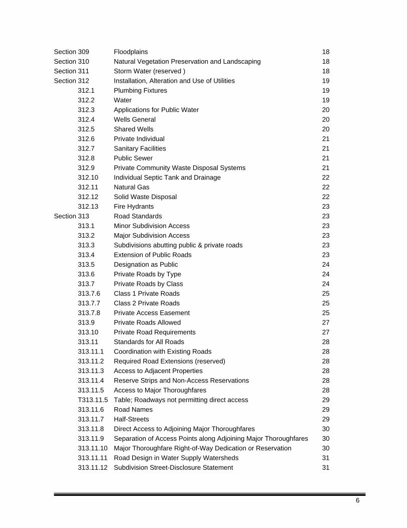
Section 309 Floodplains 18
Section 310 Natural Vegetation Preservation and Landscaping 18
Section 311 Storm Water (reserved ) 18
Section 312 Installation, Alteration and Use of Utilities 19
312.1 Plumbing Fixtures 19
312.2 Water 19
312.3 Applications for Public Water 20
312.4 Wells General 20
312.5 Shared Wells 20
312.6 Private Individual 21
312.7 Sanitary Facilities 21
312.8 Public Sewer 21
312.9 Private Community Waste Disposal Systems 21
312.10 Individual Septic Tank and Drainage 22
312.11 Natural Gas 22
312.12 Solid Waste Disposal 22
312.13 Fire Hydrants 23
Section 313 Road Standards 23
313.1 Minor Subdivision Access 23
313.2 Major Subdivision Access 23
313.3 Subdivisions abutting public & private roads 23
313.4 Extension of Public Roads 23
313.5 Designation as Public 24
313.6 Private Roads by Type 24
313.7 Private Roads by Class 24
313.7.6 Class 1 Private Roads 25
313.7.7 Class 2 Private Roads 25
313.7.8 Private Access Easement 25
313.9 Private Roads Allowed 27
313.10 Private Road Requirements 27
313.11 Standards for All Roads 28
313.11.1 Coordination with Existing Roads 28
313.11.2 Required Road Extensions (reserved) 28
313.11.3 Access to Adjacent Properties 28
313.11.4 Reserve Strips and Non-Access Reservations 28
313.11.5 Access to Major Thoroughfares 28
T313.11.5 Table; Roadways not permitting direct access 29
313.11.6 Road Names 29
313.11.7 Half-Streets 29
313.11.8 Direct Access to Adjoining Major Thoroughfares 30
313.11.9 Separation of Access Points along Adjoining Major Thoroughfares 30
313.11.10 Major Thoroughfare Right-of-Way Dedication or Reservation 30
313.11.11 Road Design in Water Supply Watersheds 31
313.11.12 Subdivision Street-Disclosure Statement 31
6
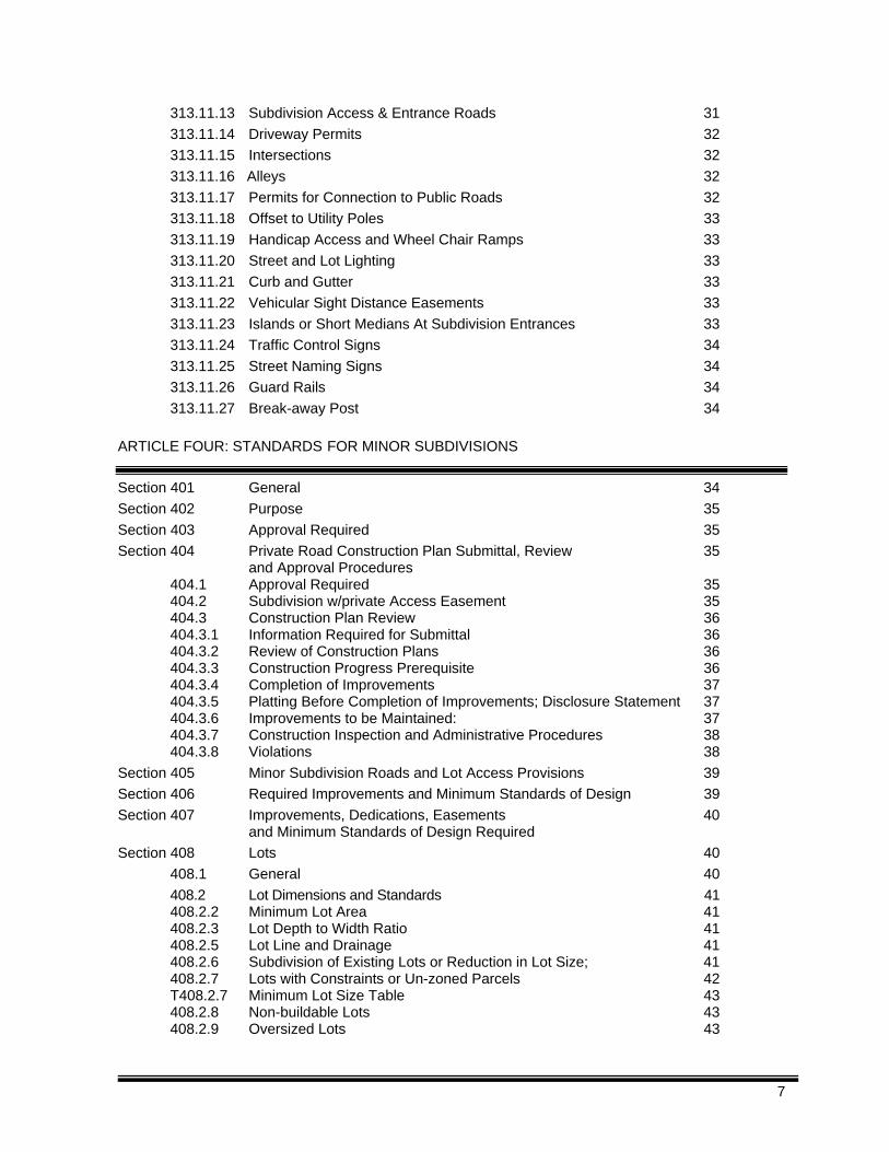
313.11.13 Subdivision Access & Entrance Roads 31
313.11.14 Driveway Permits 32
313.11.15 Intersections 32
313.11.16 Alleys 32
313.11.17 Permits for Connection to Public Roads 32
313.11.18 Offset to Utility Poles 33
313.11.19 Handicap Access and Wheel Chair Ramps 33
313.11.20 Street and Lot Lighting 33
313.11.21 Curb and Gutter 33
313.11.22 Vehicular Sight Distance Easements 33
313.11.23 Islands or Short Medians At Subdivision Entrances 33
313.11.24 Traffic Control Signs 34
313.11.25 Street Naming Signs 34
313.11.26 Guard Rails 34
313.11.27 Break-away Post 34
ARTICLE FOUR: STANDARDS FOR MINOR SUBDIVISIONS
Section 401 General 34
Section 402 Purpose 35
Section 403 Approval Required 35
Section 404 Private Road Construction Plan Submittal, Review 35 and Approval Procedures
404.1 Approval Required 35 404.2 Subdivision w/private Access Easement 35 404.3 Construction Plan Review 36 404.3.1 Information Required for Submittal 36 404.3.2 Review of Construction Plans 36 404.3.3 Construction Progress Prerequisite 36 404.3.4 Completion of Improvements 37 404.3.5 Platting Before Completion of Improvements; Disclosure Statement 37 404.3.6 Improvements to be Maintained: 37 404.3.7 Construction Inspection and Administrative Procedures 38 404.3.8 Violations 38
Section 405 Minor Subdivision Roads and Lot Access Provisions 39
Section 406 Required Improvements and Minimum Standards of Design 39
Section 407 Improvements, Dedications, Easements 40 and Minimum Standards of Design Required
Section 408 Lots 40
408.1 General 40
408.2 Lot Dimensions and Standards 41 408.2.2 Minimum Lot Area 41 408.2.3 Lot Depth to Width Ratio 41 408.2.5 Lot Line and Drainage 41 408.2.6 Subdivision of Existing Lots or Reduction in Lot Size; 41 408.2.7 Lots with Constraints or Un-zoned Parcels 42 T408.2.7 Minimum Lot Size Table 43 408.2.8 Non-buildable Lots 43 408.2.9 Oversized Lots 43
7
408.2.10 Access to Lots and Driveways 44
Section 409 Blocks 44
Section 410 Easements 45
Section 411 Minimum Setbacks 45
Section 412 Parking 46
Section 413 Residential Fencing and Walls 46
Section 414 Naming of the Development: 46
Section 415 Identification Sign Allowed: 46
Section 416 Other Signs 47
Section 417 911 Address Number Required To Be Posted 47
Section 418 Cemeteries 47
Section 419 Home Owner’s Associations 48
419.2 Submission of Owner's Association Declaration 48
Section 420 Boat Docks 49
Section 421 Construction Assurances for Minor Subdivisions 49
Section 422 Minor Subdivision Application Forms and Requirements 49
ARTICLE FIVE APPROVAL PROCEDURE FOR MAJOR SUBDIVISIONS
Section 501 Purpose 50
Section 502 General 50
Section 503 Approval Required 50
Section 504 Pre-Submittal Conference and Concept Plan Submittal and Review 50
Section 505 Completion Of Development In Phases 50
Section 506 Subdivision Application Forms & Additional Information 51
Requirements Section 507 Improvements, Dedications, and Easement Minimum Requirements 51
ARTICLE SIX CONSTRUCTION ASSURANCES
Section 601 Construction Assurances 51 ARTICLE SEVEN DEFINITIONS
Section 701.1 Usage 52
Section 702.1 Meaning of Common Words 52
Section 702.2 Words and Terms Defined 53
(Reserved)
8
Article One Purpose, Jurisdiction, Authority and Title
Section 101
Purpose This Ordinance is to establish procedures and standards for the development and subdivision of land within Vance County and will provide orderly growth and development by regulating and guiding the establishment of County subdivisions, private and public roads and reservation of right-of-ways pursuant to NCGS 136.66.10 or NCGS 136.66.11. Further, it will help with the distribution of population and traffic in a manner that will enhance public health, safety and welfare while protecting the environment and will promote a sound economically stable community.
Section 102 Jurisdiction
These regulations shall govern the establishment of each and every new subdivision and the alteration or expansion of existing subdivisions lying within the jurisdiction of Vance County and within the jurisdiction of any municipality whose governing body by resolution agrees to such regulation.
Section 103 Authority
Vance County hereby exercises its authority to adopt and enforce a Subdivision Ordinance under the provision granted by the provisions of the General Statutes of North Carolina, Chapter 153A, Article 18, Part 2.
Section 104 Title
This ordinance shall be known as the Subdivision Ordinance of Vance County, North Carolina, except herein, where it shall be known as “this Ordinance.”
Article Two
General Provisions
Section 201 Definition of Subdivision(s) and Exemptions
201.1 “Subdivision” Defined: For purposes of this Ordinance, “subdivision” means all divisions of a
tract or parcel of land into two or more lots, building sites, or other divisions for the purpose of sale or building development whether immediate or future and includes all division of land involving the dedication of a new street or change in existing streets; however, the following is not included within this definition and are not subject to any regulations enacted pursuant to this Ordinance:
Exemptions:
9
201.1.1 The combination or recombination of portions of previously subdivided and recorded lots if the total number of lots is not increased and resultant lots are equal to or exceed the standards of the county as shown in its subdivision regulations;
201.1.2 The division of land into parcels greater than ten (10) acres if no street right-of-way
dedication is involved;
201.1.3 The public acquisition by purchase of strips of land for widening or opening streets; and 201.1.4 The division of a tract into single ownership where the entire area is no greater than two
(2) acres, into not more than three (3) lots, if no street right-of-way dedication is involved and if the resultant lots are equal to or exceed the standards of the county as shown by this Ordinance.
201.2 Certification of Exemption: In accordance with State law, no map or plat showing a division of
land within Vance County’s planning jurisdiction may be recorded with the Register of Deeds unless it has been certified that the map or plat is approved in accordance with this Ordinance or is exempt and is signed by the Subdivision Administrator.
201.3 Exemption Ruling Appeal: If the owner of the property or authorized agent does not agree
with any exemption ruling he/she may appeal the decisions to the Planning Board. The appeal shall be submitted to the Planning Department subject to filing deadlines, to be reviewed at the next regular meeting of the Planning Board. Division of lands exempted from this ordinance shall have affixed to the final plat the certificate of exemption found in the subdivision policy and procedures document and must be signed by the planning director prior to recordation.
201.4 Classification of Subdivision
201.4.1 Minor Subdivision – A subdivision pursuant to this Chapter to be used only for single family detached residential uses and where the lots may have access to:
a) An existing public or private road, or b) A proposed Class 1 or 2 private road, or c) A private access easement with access to no more than four (4) lots in accordance with
Section 312.7.8
and where the proposed subdivision does not:
d) Create more than seven (7) lots including the parent tract. (not limited by time and/or ownership); and
e) Dedicate or improve any new public roads; and f) Adversely affect the development potential of the remaining or adjoining properties; and g) Preclude reasonable and safe access to the adjoining or remainder of the tract of land being subdivided via the future use of a 60 feet wide public or private street, [25 ft. if 60 ft. is not available], and h) Propose lots entirely or substantially located in a flood hazard area as defined by Vance County Ordinance 29, Flood Damage Prevention Ordinance.
All Minor Subdivisions shall be in compliance with the standards of Article Three (3) and other applicable standards of this ordinance.
10
201.4.2 Major Subdivisions – any subdivision other than a minor subdivision, including all subdivisions of land for which a non-residential use is proposed regardless of size. All Major Subdivisions shall be in compliance with Articles Four (4),& Five (5) and all other applicable sections of this ordinance.
Section 202 Prohibited Acts
202.1 After the effective date of this ordinance, the Subdivision Review Officer, pursuant to G.S. 47-
30.2, shall not certify a plat located within the territorial jurisdiction of the County if it is not in compliance with this ordinance. The Clerk of Superior Court shall not record or order the recording of a plat in conflict with this section. No permits for construction shall be issued until the subdivision has been approved and recorded as provided herein. The description by metes and bounds in the instrument of transfer or the document used in the process of selling or transferring land shall not exempt the transaction from this requirement.
202.2 After the effective date of this ordinance, no person, firm or corporation shall create a
subdivision, transfer or sell land, or use a plat showing a subdivision for any other purpose, unless such subdivision is in full compliance with the requirements of this ordinance
Section 203
Penalties for Violation
After the effective date of this ordinance, any owner or owner's agent who subdivides a portion of land within the territorial jurisdiction of this County in violation of this ordinance before the plat has been approved and recorded, shall be guilty of a Class 1 misdemeanor. The County, through its attorney or other official designated by the Vance County Board of Commissioners, may bring an injunction of any illegal subdivision, transfer, conveyance or sale of land, and the court shall, upon appropriate findings, issue an injunction and order requiring the offending party to comply with this ordinance. Each day such violation continues shall be considered a separate and distinct offense. Nothing herein contained shall prevent Vance County from taking such other lawful action as is necessary to prevent or remedy any violation.
Section 204 Interpretation.
In the interpretation and application of this ordinance all provisions shall be considered as minimum requirements and deemed neither to limit nor repeal any other powers granted under state statutes.
Section 205 Warning and disclaimer of liability.
This ordinance shall not create liability on the part of Vance County or by any officer or employee thereof for any damages that result from reliance on this ordinance or any administrative decision lawfully made hereunder.
Section 206
Abrogation and greater restrictions.
11
206.1 The adoption and implementation of this ordinance is not intended to repeal, abrogate, annul, impair or interfere with any existing easements, covenants, deed restrictions, agreements, rules, regulations, or permits previously adopted or issued pursuant to law or other Vance County Ordinances. Should a conflict arise between this ordinance and any other applicable regulations, the more restrictive shall prevail.
206.2 The following may impose additional regulations for land and structures located in Vance County and
are hereby adopted and incorporated into this ordinance by reference as though it was copied herein fully.
206.2.1 The North Carolina State Building Code, as adopted by the Building Code Council and
enforced by State and local code enforcement officials, and including all volumes. 206.2.1 The National Manufactured Home Construction and Safety Standards. 206.2.3 The National Flood Insurance Flood Damage Prevention Ordinance. 206.2.4 The Vance County Watershed Protection Ordinance.
206.3 The following agencies may impose additional regulations for land and structures located in Vance County and are hereby referenced.
206.3.1 The North Carolina Department of Transportation. 206.3.2 The North Carolina Department of Human Resources, Environmental Health Division and the
Vance County Department of Public and Environmental Health. 206.3.3 North Carolina Division of Water Quality – Sedimentation Control. 206.3.4 Other Federal or State Agencies
206.4 For subdivisions required to provide or proposing to provide public water and/or public sewer
service, the City of Henderson regulations shall govern only the connection to and design, construction, and maintenance of these systems.
Section 207
Other approval required. 207.1 The granting of an approval under the provisions of this Ordinance shall in no way affect any
other type of approval required by any other statute or ordinance of the State or any political subdivision of the State, or of the United States, but shall be construed as an added requirement.
207.2 Nothing in this ordinance shall be deemed to require any change in the plans, construction or
designated use of a building or structure where a building permit was secured prior to the adoption of this ordinance, so long as said building permit remains valid.
Section 208
Waiver 208.1 Where in its opinion a waiver will result in:
a) Equal or better performance in furtherance of the purposes of this Ordinance, or
12
b) Where strict adherence to the provisions of this Ordinance would cause an unnecessary hardship due to topographical or other conditions peculiar to the site, or
c) Where through an unintentional error by the applicant, his agent, or the reviewing staff, there
is a minor violation of a standard in this Article, where such violation is not prejudicial to the value or development potential of the subdivision or adjoining properties,
The Planning Board may approve a waiver or a waiver with conditions when such approval will result in meeting the intent of the ordinance.
Section 209
Zoned Areas and Other Plans
In areas of the county where a Zoning Ordinance is in effect, development shall be permitted only in conformance with the regulations of the zoned district in which they are located, and any other officially adopted plans.
Section 210
Existing Subdivision 210.1 The standards of this ordinance are not applicable to existing subdivisions or existing lots in a
subdivision for which a building permit has been issued prior to the effective date of this ordinance and has not expired; or for which an occupancy certificate has been issued, provided that the subdivision plat or deed of transfer has been recorded prior to the effective date of this ordinance.
210.2 Changes to such lots after the effective date of this ordinance including, but not limited to, lot size, lot location, lot configuration or lot lines shall be in conformance with this ordinance. (legal re-combinations excepted)
210.3 The standards of this ordinance shall not apply to lots or subdivisions being developed in good faith prior to the effective date of this ordinance, provided the sub-divider submits the following:
210.3.1 Evidence of a formal plan prior to the effective date of the ordinance. 210.3.1.1 Provides the Planning Department within Ninety (90) days after the effective date of
the ordinance, a copy of the subdivision plan which meets the minimum requirements of NCGS 47-30 prepared prior to the effective date of the ordinance; and
210.3.1.2 Evidence of Substantial Expenditure of Resources 210.3.1.3 Provides documentation, within Ninety (90) days after the effective date of this
ordinance, proving the substantial expenditure of resources. The owner/developer shall bear the burden of proof.
210.4 The adoption of this Ordinance shall not constitute permission to continue or initiate any unsafe, unhealthy activity, nor shall it relieve the owner/developer of responsibility to comply with all appropriate and/or pertinent regulations or standards. 210.5 An undeveloped recorded subdivision shall be subject to any state or local laws or standards
which have changed since the time of the recording, if, such law or standard are specifically retro-active.
13
210.6 Subdivisions or phases of subdivisions not legally recorded prior to the adoption of this ordinance shall not be recorded unless the subdivision meets the requirements of this ordinance, except as in provided in Section 210.1 above.
Section 211 Amendments
The Board of Commissioners may approve amendments to this ordinance. The request for such amendments may be initiated by the Board of Commissioners, the Planning Board, County staff members or by the public. Request for amendments to this ordinance shall first be reviewed by the Planning Department and the County Attorney and then forwarded to the Planning Board with any recommendations. The Planning Board shall schedule a public hearing and shall review the recommendation(s) and comments from the public hearing prior to sending the request and recommendations to the Board of Commissioners for action.
Section 212
School Sites on Land Use Plan (reserved)
Section 213 Authorization to Proceed Required
No development activity shall commence until confirmation of compliance to this ordinance and the specific issue of permission to proceed.
213.1 Permits for Lots of Record: Permits for development and construction shall not be issued except
as is allowed in Section 210.1 for any lot not of record at the time of adoption of this ordinance (November 4, 1999) until compliance with applicable state and local laws has been met.
213.2 Plot Plan Required: No development permit shall be issued for a lot in a minor or major subdivision
proposing direct access to a major thoroughfare in Vance County until a Plot Plan (see definition of Plot Plan, Article Seven (7), Definitions) has been submitted to the Planning Department, reviewed for applicability of all regulations, and approved and signed by an Authorized Review Officer.
Section 214
Fees The Vance County Board of Commissioners shall establish and authorize the collection of appropriate fees to recover the cost of operation. These fees shall be established in a Policy and Procedures document and shall be approved by the Board of Commissioners. The fee schedule shall be reviewed on an annual basis.
Section 215 Severability
Should any section or provision of this Ordinance be declared invalid or unconstitutional by any court of competent jurisdiction, the declaration shall not affect the validity of this Ordinance as a whole or any part thereof that is not specifically declared to be invalid or unconstitutional.
Section 216 Effective Date
This Ordinance shall take effect and be in force on November 4, 1999.
14
Article Three
Section 300 General Design Standards
301
General The Vance County Planning Board has the right and responsibility to review, and require revisions to any proposed subdivision plat. The purpose of this review is to:
a) Relieve demonstrable adverse impacts of the development upon public safety, health, or welfare;
b) Determine that adequate and sustainable utilities and services are available for the development;
c) Protect public investments in roads, drainage facilities, sewage facilities, public water supplies;
d) Preserve the value of land and development; and
e) Assure that the regulations of Vance County are upheld.
302 Purpose
302.1 The purpose of this section is to establish standards and procedures for the development of
major and minor subdivisions while preserving the natural environment and resources, enhancing the economic growth, and providing standards to protect public health, safety and welfare in the County.
302.2 Landscaping shall preserve the natural environment by minimizing tree and soil removal and
providing enhancement to the neighboring development areas. Natural topography and drainage shall be maintained and steps must be taken to minimize the impact of the development on the local environment. Swales and other natural channels shall be maintained.
302.3 Roads shall be designed and located as to maintain and preserve natural topography, cover,
significant landmarks, and natural vegetation, to minimize cut and fill and shall preserve and enhance views and vistas on or off the subject parcel.
302.4 Proposed developments shall be related harmoniously to the terrain. 302.5 The removal or disruption of historic, traditional or significant uses, structures, or architectural
elements shall be minimized insofar as practical, whether these exist on the site or on adjacent properties.
Section 303
Improvements, Dedications, Easements and Minimum Standards of Design Required
Each subdivision shall contain the improvements specified in this article, which shall be installed in accordance with the requirements of this ordinance. Land shall be dedicated, reserved or easements provided in each subdivision as specified in Articles Three (3), Four (4), and Five (5 ).
15
Section 304 Suitability of Land
304.1 Land which has been determined to pose an ascertainable danger to life or property by reason
of its unsuitability for the use proposed, shall not be platted for that purpose, unless and until the necessary measures to correct said conditions and to eliminate said dangers on the basis of engineering or other expert surveys have been taken.
304.2 Areas previously used for disposal of solid waste, construction debris, appliances and etc. shall
not be subdivided until site the has been brought into compliance with the requirements of state and local health and environmental agencies and have been determined by the appropriate design professional to be suitable for the purpose proposed.
304.3 Areas previously used for surface or sub-surface mining or quarrying shall not be subdivided
unless determined by appropriate state and local environmental agencies, health agencies and design professionals to be suitable for the use proposed, poses no threat to life, property or public safety.
304.4 Where a parcel proposed to be subdivided adjoins a parcel with any of the conditions described
in Sections 304.1, 304.2, or 304.3 said parcel shall be tested to assure that conditions on the adjoining property will pose no threat to life or property or public safety and will have no impact on the proposed subdivision.
304.5 Areas of a project that are located within a floodplain or special flood hazard area shall not be
subdivided, except as provided in Vance County Ordinance 29, National Flood Insurance Flood Damage Prevention Ordinance.
Section 305
Soils
305.1 A Subdivision with five or more lots or any subdivision requesting a reduction in minimum lot size (see Table T408.2.7) shall provide the following information at the time of preliminary subdivision plat application:
305.1.1 A soil map and soil evaluation of the subdivision site, prepared by a soil scientist
registered in North Carolina, showing:
a) All wetlands or hydric soils on this site, and
b) All areas suitable for the location of on-site septic systems, and
305.1.2 A plan drawn to scale showing the soils information along with the locations of:
a) Proposed and existing buildings
b) Proposed and existing wells
c) Proposed and existing components of septic systems
d) Proposed and existing driveway accesses
305.2 A subdivision with four or fewer lots shall:
305.2.1 Provide the information required in Section 305.1.1, or 305.2.2 Obtain a septic tank permit(s) after preliminary subdivision plat approval.
305.3 All lots within any subdivision (regardless of size or number of lots) submitted for subdivision
plat approval shall be staked with property lines clearly identified.
16
Section 306 Grading and Drainage:
306.1 A property shall not be graded, cleared or otherwise changed until:
a) A preliminary subdivision plat has been approved; b) An evaluation has been made of the existing vegetation, slopes and soils, and c) A sedimentation and erosion control plan has been approved by the Department of Health and
Natural Resources, Land Quality Section, if such is required, or by Vance County at such time as a local ordinance is adopted, in accordance with the North Carolina “Sedimentation Pollution Control Act of 1973.”
Cutting or clearing required for the purposes of soils evaluation may be permitted where necessary. Cutting, clearing and grading for agricultural purposes is exempt from this Ordinance.
306.2 Except for surplus top soils from roads, parking areas and building excavation, resident top soil
shall be used within the project.
306.3 Grading shall be limited and natural vegetation preserved where reasonably possible.
306.4 Disruption of the natural sheet flow of storm water shall be minimized to the greatest extent
practicable.
306.5 Natural vegetation within thirty (30) feet of existing drainage, natural creeks, rivers, natural springs or ponds shall be left intact. These surface features shall not be altered except for necessary bank stabilization and no fill shall be allowed in water features or natural flood plains.
306.6 A development greater than one (1) acre shall not be altered or create erosion, drainage, or
runoffs, on it's own or adjacent properties. A grading or drainage plan, if required, shall be prepared by a design professional as is allowed by North Carolina General Statutes. For sites one (1) acre or less, grading or erosion control plans may be approved by the Planning Department.
306.7 Final clearing, grading and drainage shall be in compliance and consistent with the North
Carolina International Building Codes, for general construction, the North Carolina International Residential Code for one, and for two family residential construction, local codes and ordinances. Building sites shall be located such that water will be diverted away from structure(s) and will not pond or accumulate under or around structure(s). Lots shall be graded, landscaped and have a suitable vegetative cover.
306.8 No banks shall be created or modified in the development with a slope steeper than one foot (1)
rise to four foot (4) run. If existing non-compliant slopes or banks along natural waterways are left undisturbed, unaltered and the water flow is not increased, they are not required to be re-graded unless unusual conditions exist, as is determined by the Planning Department.
306.9 Grading at all intersections shall include provisions for vehicular site distance. 306.10 Grading of individual driveways shall not divert water to roadways or adjoining properties.
17
Section 307
Erosion Control and Sedimentation Management
307.1 Clearing, grading or other land disturbance activities on areas greater than one (1) acre must have the required erosion and sedimentation plans filed with the Department of Health and Natural Resources, Land Quality Section (and/or with Vance County at such time as a local ordinance is adopted) at the same time as the preliminary subdivision plat submittal. Land disturbance activities on lots of one (1) acre or less may require an erosion control plan if determined necessary by the Vance County Planning Department based on site conditions or unusual circumstances. Construction or building permits shall not be issued until required erosion control plans and measures are in place.
Section 308
Water Supply Watershed Protection 308.1 All subdivisions located either partially or totally within the boundaries of an identified
watershed protection area shall conform to the requirements of the Vance County Water Supply Watershed Protection Ordinance, Ordinance 25.
Section 309 Floodplains
309.1 All subdivisions located either partially or totally within the boundaries of a floodplain shall
conform to the requirements of the Vance County Flood Damage Prevention Ordinance, Ordinance 29. (FEMA Based)
Section 310
Natural Vegetation Preservation and Landscaping 310.1 Natural vegetation or landscaping is necessary to promote attractive development, to provide a
visual and audio buffers between uses, to protect and preserve water quality, to prevent erosion and sedimentation, to preserve the appearance and character of the surrounding area, and to delineate, define and separate vehicular and pedestrian passageways within a subdivision.
310.2 The developer shall include mature trees and natural plant materials in the design of the
subdivision to the greatest extent feasible. All banks and open areas shall be landscaped with grass or other suitable plant materials where defined by the Department of Health and Natural Resources, Land Division to prevent erosion.
310.3 Buffer easements shall be constructed in compliance with and as required by Section 307.1 If
entrances to a subdivision are to be landscaped, the following conditions shall be met:
310.3.1 Any landscaping within public road right-of-way shall be approved by the NCDOT. 310.3.2 All dead or damaged planted materials shall be replaced for a one (1) year period.
310.4 No plant materials exceeding mature heighth of thirty-six inches (36”) shall be planted within
any vehicular sight triangle.
Section 311 Storm Water (reserved)
18
Section 312 Installation, Alteration and Use of Utilities
312.1 Plumbing fixtures and sewage disposal systems shall conform to all applicable codes and
regulations.
312.1.1 No property owner shall allow the connection of any other dwelling to the utilities of his lot.
312.1.2 The subdivider shall provide individual utility connections for each lot within the subdivision. Each subdivision lot shall be provided a connection to a power supply, a connection to an approved water supply and a connection to an approved sewage waste disposal system.
312.1.3 All utilities shall be installed underground, except where extreme geographic or conditions
of topography make this requirement unreasonable. Where subdivision consists of all oversized lots and deed restrictions or zoning prevent further re-subdivision, a subdivision may be submitted for consideration to the Planning Board for approval of above ground utility services.
312.1.4 All major above ground utility equipment, other than individual lot service equipment, shall
be located at the rear of side lot lines (corner lots only) or along side lot lines No above ground utility equipment shall be installed at intersections and/or within the required vehicular sight distance; except for traffic signalization equipment.
312.1.5 Easement for and the installation of all underground utilities shall be coordinated to
minimize land disturbance and to minimize conflict during construction.
312.1.6 Placement of utilities shall comply with the NC Building Codes.
312.1.7 No permit for the construction of or placement of a building shall be issued in a subdivision until:
a) A water supply system has been installed and approved (except individual wells), and
b) A sewage disposal system has been installed and approved (except individual septic tanks).
312.1.8 No building within a subdivision shall be occupied until:
a) A connection to a power supply is complete,
b) A connection to an approved water system is complete,
c) A connection to an approved sewage system is complete, and
d) All required inspections are completed and final approvals given.
312.2 Potable Water: There shall be a safe, adequate, continuous and conveniently located potable water supply provided for each lot within a subdivision. Potable water supply shall be in compliance with the applicable edition of the North Carolina Plumbing Code.
312.2.1 If the development is to be located within three-hundred (300) feet of a public water
system, connection shall be made thereto and its supply used exclusively, except where extreme geographic or topographic conditions make this requirement unreasonable. Where a subdivision consists of all oversized lots, and deed restrictions or zoning prevent further re-subdivision; the subdivision may be submitted for consideration to the Vance County Planning Board for waiver of connection to a public water system. There shall be no cross-connections between public and private water systems.
19
312.2.2 When a public water system is not available or where capacity (and/or line size) is not sufficient for extension, individual wells, shared wells or community wells shall be installed, inspected, tested approved and maintained in accordance with the most current “Rules Governing the Protection of Private Water Supplies”, Section .1700 of the North Carolina Administrative Code, “Rules Governing the Sanitation of Protection of Water Supplies, T15A NCAC 18A.1700 of the North Carolina Administrative Code”, “Well Construction Standards", Subchapter 2C, Section .0100 and other applicable State regulations and guidelines.
312.2.3 Dry lines may be required to be installed where public water supplies are anticipated
soon after completion of the project.
312.3 Applications for Public Water Supplies for new subdivisions shall contain:
312.3.1 Calculations showing the maximum daily water usage of the development shall be submitted.
312.3.2 A certification shall be provided that the public water system will provide water to the
development.
312.3.3 Oversized lines may be required to be installed with the participation of the City of Henderson or with the participation of Vance County.
312.3.4 Design standards, installation, connections, and approvals of all components of the water
system shall be as required by the public water system. 312.3.5 Fire hydrants, where required, shall be installed in compliance with the North Carolina
administrative, building, plumbing, and fire codes, local fire department requirements and other applicable local ordinances and standards.
312.4 Wells - General
312.4.1 There shall be no subdivision of any parcel of land nor any parcel offered as a gift, for
sale or lease where ground already contains contaminants in excess of State standards unless the applicant submits evidence of how water quality will be improved or treated, the source identified and resolved.
312.4.2 A one-hundred (100) feet contaminate free zone must be maintained around private or
community wells. 312.4.3 Dry hydrants may be required in areas near large bodies of water to facilitate fire
protection to the development. 312.5 Shared Wells, Community Wells, or Community Water Systems
312.5.1 Calculations showing the maximum capacity of the water system shall be submitted
along with calculations showing the maximum daily water usage of the development. 312.5.2 Where shared wells or community wells are to be employed a written, perpetual
agreement shall be recorded specifying:
a) That the water supply to each lot is a permanent supply,
b) Which party(ies) will have responsibility for the physical and financial maintenance of the community water system,
20
c) That each property owner shall have adequate assurances of a continued water supply and have immediate remedial action should maintenance or supply be discontinued for any reason, and
d) The frequency and specifications of well testing. 312.6 Private Individual Wells
312.6.1 Where individual septic tanks are to be used in conjunction with private individual wells,
the approximate, proposed location of the well for each lot shall be shown. The purpose is to show the proposed proximity from proposed well sites to proposed sewage waste disposal systems.
312.6.2 No subdivision of an existing lot or lots shall be allowed where an individual well would
be separated from the structure it serves; except where the well is to become a shared well or community well (see Community Water Systems above). No existing lot shall be reduced in size such that compliance with respect to any development, health or safety requirements cannot be met.
312.7 Sanitary Facilities: Each lot within an approved subdivision shall be provided with an
adequate sewage disposal system. The use of pit privies or portable toilets (beyond construction phase) are specifically not permitted within a subdivision. All sewage waste from toilets, showers, bathtubs, lavatories, wash basins, refrigerator drains, sinks, faucets, and water-using appliances not herein mentioned shall be piped into an approved sewage disposal system.
312.7.1 If the development is to be located within 300 feet of a public sewage system,
connection shall be made thereto and used exclusively; except where extreme geographic or topographic conditions make this requirement unreasonable or where there is a necessity for crossing a ridge line such that pumping of wastes would be necessary.
312.7.2 When a public sewer system is not available or where capacity (and/or line size) is not
sufficient for extension, a private sewage system or an individual septic tank system shall be constructed, inspected, approved and maintained in accordance with the requirements of the N.C. Department of Environment, Health and Natural Resources and with the regulations of the Vance County Board of Health.
312.7.3 Dry lines may be required to be installed where public sewer installation is anticipated
after completion of the project. 312.8 Public Sewer:
312.8.1 Calculations showing the maximum daily effluent generated by the proposed
development shall be submitted.
312.8.2 A certification shall be provided that the public sewage system will allow connection and provide service to the development.
312.8.3 Oversized lines may be required to be installed with the participation of the City of
Henderson or with the participation of Vance County.
312.8.4 Design standards, installation, connections, and approvals of all components of the sewer system shall be as required by the public sewer system.
312.9 Private Community Waste Disposal System: Private or Community sewage systems shall be
located a minimum of one-hundred (100) feet from all existing wells and proposed wells in future
21
subdivision phases. No underground utilities, roads, recreation areas, or structures shall be located in drainage field or replacement drainage fields for such a system. 312.9.1 No existing lot shall be reduced in size such that compliance with respect to any
development, health or safety requirements cannot be met.
Note: For lots with existing private community waste disposal systems - Evaluations of systems are based on the number, size, configuration and soil types of the existing lots. Changes could render the evaluation, subsequent permit and approval invalid.
312.9.2 Private Community Waste Disposal Systems may be installed on land held by a Home
Owner’s Association where installation, maintenance, and replacement is in the form of a written, recorded perpetual agreement and with the agreement of the Vance County Public Health Department and the State of North Carolina.
312.10 Individual Septic Tank and Drainage Field:
312.10.1 No subdivision of an existing lot or lots shall be allowed where a septic tank, drainage
field or replacement drainage field would be separated from the structure it serves. No existing lot shall be reduced in size such that compliance with respect to any development, health or safety requirements cannot be met.
Note: For lots with existing septic tanks - Evaluations of lots for septic tank installation are based on the size, configuration and soil types of the existing lot. Changes to this lot size or configuration could render the evaluation, subsequent permit and approval invalid.
312.10.2 A sewage system shall be installed on the lot it is intended to serve; except individual
septic tank systems may be installed on land held by a Home Owner’s Association where installation, maintenance and replacement is in the form of a written, recorded perpetual agreement and with the agreement of the Vance County Public Health Department and the State of North Carolina.
312.11 Natural Gas:
Extension and installation of natural gas lines to subdivisions is encouraged in areas of the County where natural gas is available.
312.12 Solid Waste Disposal:
The storage, collection, and disposal of solid waste shall be so conducted as to comply with state regulations and create no health hazards, rodent harborage, insect breeding areas, safety or fire hazards or pollution.
312.12.1 Construction debris, stumps or other similar materials shall not be buried within a
subdivision or be left on:
a) a lot,
b) a road (public or private) or an easement used for access to lots,
c) a common area within a subdivision.
312.12.2 The developer shall be held responsible for storage, collection, and disposal of all construction debris within the subdivision. The responsibility for compliance shall not be transferred to another person; however, the Developer may require sub-contractors to provide dumpsters for construction debris.
22
312.12.3 The owner of each lot within a subdivision shall be held responsible for the proper storage, collection, and disposal of solid waste.
312.13 Fire Hydrants (See Section 312.3.5)
312.13.1 Dry hydrants may be required in areas near large bodies of water to facilitate fire
protection to the development.
Section 313 Road Standards
Transportation, Roadway Access, and Circulation Standards
Roads Must Meet Standards: Any extension of an existing road or any creation of a new road must meet or exceed the standards
of this Ordinance.
313.1 Minor subdivision access: shall be in compliance with Article four (4) and Section 405. 313.2 Major Subdivision Access: Each lot in a major subdivision shall front on and have ingress from
and egress to a dedicated public road meeting the standards of this Section, except as provided for in Section 313.7, private roads.
313.3 Public or Private roads designated on Plat: Public or private roads within, abutting, or
adjacent to a proposed subdivision shall be designated on the preliminary and final plats and shall be arranged consistent with the use, character, extent, width, grade, proposed and existing transportation patterns, topographical and natural features, shall enhance public convenience and safety and shall be constructed and maintained to the standards of this ordinance, the minimum construction standard established by the NC Department of Transportation or the standards of the American Association of State Highway Officials. If there is a conflict between any of these standards, the more restrictive shall apply.
313.4 Extension of Public Roads: Any public road that is proposed to be extended shall be extended
as a public road and shall cause a subdivision application to become a major subdivision and subject to the standards for major subdivisions contained in this ordinance.
313.4.1 A full set of Construction Drawings, including, but not limited to, right-of-way, roadway
width, center line data, curve data, plan and profile sheets, location of all proposed traffic control devices and drainage structures shall be prepared by a professional engineer, or other design professional as allowed by North Carolina General Statutes, submitted, and approved prior to commencing construction.
313.4.2 The County shall have the option of contracting for the review of said plans at the
developer’s expense or shall review plans with appropriate staff. 313.4.3 Construction shall be inspected and certified by a professional engineer, or other
design professional allowed by North Carolina General Statutes, as complying with NCDOT and/or Vance County specifications. Laboratory test reports shall be submitted with one complete set of certified as-built plans for roadway construction at the completion of construction. Permits from the Vance County Planning Office or the North Carolina Department of Transportation for driveway, street, public or private connection to an existing road system must be approved and issued prior to the issuance of development permits.
313.4.4 Construction and maintenance shall occur in accordance with the North Carolina
Department of Transportation Best Management Practices (BMP) and shall occur in
23
accordance with the North Carolina Erosion and Sedimentation Act of 1973 and subsequent amendments.
313.4.5 In lieu of actual prior approved construction, Construction Assurances as required in
Article Six (6) of this ordinance shall be required before final plat approval.
313.5 Public Roads:
313.5.1 Designation of any road on a plat as public road shall be conclusively presumed to be an offer of dedication to the public.
313.5.2 Roads serving the general public and determined by the Planning Board as through
roads within a local road network shall be designated as public roads. 313.5.3 All lots within a subdivision shall abut a dedicated public road except where the use of
a private road is permitted in Article Three, Subdivisions, or permitted in accordance with the provisions of Section 313.8.9 Private Roads below.
313.6 Private Roads by Type: A private road shall be designated as existing, new, or extended, as
described below, on a Minor Subdivision Plat.
313.6.1 Existing Private Roads: Private roads, the existence of which can be established by documentary evidence, aerial photograph, or judicial decree, are existing private roads. That portion of the existing private road which serves as frontage for new lots in the subdivision must meet or exceed the Class 1 or Class 2 private road standards in Section 313.7.6, 312.7.7, & 312.7.8 .
313.6.2 New Private Roads: New private roads within a proposed subdivision that serve as
frontage and/or access for lots must meet or exceed the Class 1 or Class 2 private road standards in Section 313.7.6 & 312.7.7.
a) A connecting private access road, if any exists, must meet the Class 1 minimum
private road standards of this Article.
313.6.3 Extended Private Roads: Extended private roads are considered to be new private roads for the purpose of determining the required Class of road.
313.7 Private Road By Class: Private Roads and private access easements by Class, Right-of-way,
Ownership, and Construction Standards
313.7.1 Disclaimer: The standards described herein are the minimum set forth by Vance County. The County has not determined, and is not responsible for determining that these standards are adequate or appropriate for all situations and uses by land owners. Roads not meeting NCDOT standards will not be accepted by NCDOT until compliance is achieved.
313.7.2 Ownership – A class 1 or Class 2 private road right-of-way and the improvements
therein shall be held in common ownership (e.g. Home Owner’s Association) by those properties fronting on and/or having access to such road.
313.7.3 Right-of-way width. Minimum right-of-way width required: sixty (60) feet 313.7.4 Safe 2-way passage of traffic. All private roads and private access easements shall be
designed and constructed to permit the safe two way passage of traffic based upon the appropriate construction standards for private roads as shown in Section 313.7.6 through 313.7.8 below.
24
313.7.5 Safe Intersection. The design, location, and improvement of all private roads and private access easements shall provide for safe intersection with public and private roads; for safe passage of public service and emergency vehicles; and protection of adjoining property.
313.7.6 Obstacles. All private road and private access easement rights-of-way shall be free and
clear of obstacles including vegetation, abandoned vehicles, and other similar objects. 313.7.7 Class 1 Private Road
313.7.7.1 Maximum Number of Lots permitted to have access: None 313.7.6.2 Construction Standard: The road shall be constructed in accordance with the
North Carolina Department of Transportation–Subdivision Roads, Minimum Construction Standards except that:
a) No pavement is required.
313.7.7 Class 2 Private Road 313.7.7.1 Maximum Number of Lots permitted to have access: Seven (7) 313.7.7.2 Construction Standard: The road shall be constructed in accordance with the North
Carolina Department of Transportation – Subdivision Roads, Minimum Construction Standards except that:
a) No pavement is required.
b) The minimum width of the road surface may be reduced to sixteen (16) feet, and
c) There shall be at least one shoulder five (5) feet in width.
313.7.8 Private Access Easement
313.7.8.1 Ownership - A private access easement and the improvements therein may be held in:
a) Common ownership (e.g. Home Owner’s Association) by those properties fronting
on and/or having access to such road, or
b) Individual ownership of the property owner of the lot of record from which a minor subdivision is created, provided that the individual owner shall be responsible for the construction and perpetual maintenance of the access drive required to be constructed within the easement. (See Section 404.3.6 for maintenance documents required at time of minor subdivision application.)
313.7.8.2 Minimum right-of-way width required: Twenty-five (25) feet. 313.7.8.3 Maximum Number of Lots permitted to have access: Four (4) 313.7.8.4 Construction Standard: An access drive shall be constructed in accordance with
Sections 263.8.3 above and:
a) The minimum width of the access drive shall be twelve (12) feet of vehicular travel surface, and
b) There shall be at least one stable shoulder five (5) feet in width.
25
313.8.9 Private Roads Allowed
313.8.9.1 Permitted Use Of Private Roads within Condominium, Townhouse, and Gated
Community Development: The design, location, and improvement of private roads shall provide for safe intersection with public roads, safe passage of public service and emergency vehicles, and protection of adjoining parcels. Private roads shall be permitted in major subdivisions on land held by a homeowners association or where public access is restricted by means of a gate or guardhouse.
313.8.9.1.1 A copy of the Articles of Incorporation and Bylaws of the homeowners
association providing for one lot, one vote membership formula shall be filed with the Planning Department.
313.8.9.1.2 The governing covenants shall require the payment of periodic assessments to
the homeowner's association on no less than an annual basis and shall be sufficient to maintain the private streets or roadways of the subdivision. Delinquent unpaid assessments shall constitute a lien against the assessed properties.
313.8.9.1.3 School Bus Access: Provisions shall be made for a school bus to enter
subdivision, turn around without backing up and exit in the shortest distance possible and a letter of permission (wavier of liability) for the bus to enter and exit shall be filed with and approved by the Superintendent of Schools. A copy of such approval shall be filed the Planning Department.
313.8.9.1.4 Postal Delivery Access: Provisions shall be made for postal delivery to enter
subdivision, turn around without backing up and exit in the shortest distance possible and a letter of permission (wavier of liability) for the bus to enter and exit shall be filed with and approved by the Postal Service. A copy of such approval shall be filed the Planning Department. Postal delivery locations shall not be within the public right-of-way, within a vehicular sight triangle or impede the flow of traffic into or out of the subdivision.
313.8.9.2 Other Permitted Use of Private Roads. The Planning Board may approve
construction and use of private roads where:
a) An existing, new, or extended private road included as part of a proposed subdivision cannot serve as part of a through road within a local road network because physio-geographical characteristics or other intervening man-made characteristics make it impractical or unreasonable to extend the public roads to connect to adjoining roads or land, or
b) There will be fewer than two (2) lots for each one-tenth of a mile of road and deed
restrictions or zoning prevent further re-subdivision, or c) A road is less than two-tenths of a mile, serves fewer than four (4) lots and deed
restrictions or zoning prevent further re-subdivision, or d) A cul-de-sac is less than two-tenths of a mile, serves fewer than four (4) lots and
deed restrictions or zoning prevent further re-subdivision, or e) A subdivision access road* is less than 1 mile and provides ingress and egress for
fewer than five (5) lots, or f) A subdivision access road* is over one mile in length and provides ingress and
egress for fewer than an average of five (5) lots per mile, or
26
* Subdivision Access Road - This is a road built through vacant property to
provide access to the property being developed. This road would not have lots platted along it. (NCDOT Definition)
g) all adjoining land has been previously developed and the proposed subdivision
does not:
Provide access to adjoining property,
Create any new or residual parcels which do not satisfy the requirements of this ordinance or other applicable local and State controls,
Involve the extension of public sewerage or water lines or the creation of new
drainage easements, and
Create lots or locate a road entirely or substantially in a flood hazard area as defined by Vance County Ordinance 29, Flood Damage Prevention Ordinance.
313.10 Private Road Requirements: The minimum standards for private roads are as follows:
313.10.1 The design, location, maintenance and improvement of private roads shall provide for
safe intersection with public roads, safe passage of public service and emergency vehicles, and protection of adjoining parcels.
313.10.2 The applicant shall submit proposed agreements or covenants ensuring continued use
and maintenance of any existing, platted or proposed private roads by landowners served by such roads. These agreements will specify how responsibility for road maintenance will be apportioned among the landowners served, and will provide enforcement rights for the maintenance agreement.
313.10.3 For all subdivisions with class 1 or class 2 private roads, a full set of Construction
Drawings including, but not limited to, right-of-way width and location, roadway width, center line data, curve data, plan and profile sheets, location of all proposed traffic control devices and drainage structures shall be prepared by a professional engineer, or other design professional as allowed by North Carolina General Statutes, submitted, and approved prior to commencing construction.
313.10.4 The County shall have the option of contracting for the review of said plans at the
developer’s expense or shall review plans with appropriate staff. 313.10.5 Construction shall be inspected and certified by a professional engineer, or other
design professional allowed by North Carolina General Statutes, as complying with Vance County and/or NCDOT specifications. Laboratory test reports shall be submitted with one complete set of certified as-built plans for roadway construction at the completion of construction.
313.10.6 Construction and maintenance shall occur in accordance with the North Carolina
Department of Transportation Best Management Practices (BMP) and shall occur in accordance with the North Carolina Erosion and Sedimentation Act of 1973 and subsequent amendments.
313.10.7 In lieu of actual prior approved construction, Construction Assurances as required in
Article 6 of this ordinance shall be required before final plat approval.
27
313.11 Standards for All Roads:
313.11.1 Coordination with Existing Road System. The proposed road layout within a subdivision shall be coordinated with the existing and proposed road network within the surrounding area (as established on the adopted Thoroughfare Plan for Vance County and the road layout within existing and approved subdivisions in the general area), including the extension and interconnection of roads between adjacent properties where appropriate to the development of a local road network.
313.11.2 Required Road Extensions to Adjoining Property – (Reserved) 313.11.3 Access to Adjacent Properties or Future Phases
All roads providing access to adjoining property shall be located so as to best ensure the safe, convenient, and efficient movement of traffic within a local road network as well as the orderly development of adjacent properties. All dead end private roads must terminate in a cul-de-sac for turning around of emergency equipment. Where an adjoining property gains access through the property contained in the proposed minor subdivision to a public road, this access shall be:
a) Included in the private road right-of-way which shall be conforming with the lines of
such existing easements, or b) The original access may be abandoned and an alternative access easement, which
follows a new private road alignment, dedicated and recorded and c) The lots shall be counted toward the number of lots permitted on a Class 1 or Class 2
private road.
313.11.4 Reserve Strips and Non-Access Reservations. Reserve strips or non-access reservations that control access to roads, waterways, parks or the like, and other reserved strips shall be permitted only if their purpose, location, dimensions and manner of control is approved by the Planning Board.
313.11.5 Access to Major Thoroughfares. Subject to the restrictions in this article, direct
driveway access from minor subdivision lots shall be permitted to and from numbered NCDOT (public) roads in Vance County except for those roads identified as Interstate Highway, Principal Arterial, Minor Arterial, Major Collector, and Minor Collector roads in the Thoroughfare Plan for Vance County and table T313.11.5
28
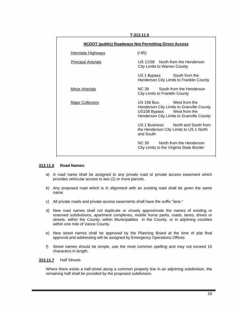
T-313.11.5
NCDOT (public) Roadways Not Permitting Direct Access
Interstate Highways (I-85) Principal Arterials US 1/158 North from the Henderson
City Limits to Warren County US 1 Bypass South from the
Henderson City Limits to Franklin County Minor Arterials NC 39 South from the Henderson
City Limits to Franklin County
Major Collectors US 158 Bus. West from the Henderson City Limits to Granville County
US158 Bypass West from the Henderson City Limits to Granville County
US 1 Business North and South from
the Henderson City Limits to US 1 North and South
NC 39 North from the Henderson
City Limits to the Virginia State Border
313.11.6 Road Names:
a) A road name shall be assigned to any private road or private access easement which
provides vehicular access to two (2) or more parcels. b) Any proposed road which is in alignment with an existing road shall be given the same
name. c) All private roads and private access easements shall have the suffix “lane.” d) New road names shall not duplicate or closely approximate the names of existing or
reserved subdivisions, apartment complexes, mobile home parks, roads, lanes, drives or streets. within the County, within Municipalities in the County, or in adjoining counties within one mile of Vance County.
e) New street names shall be approved by the Planning Board at the time of plat final
approval and addressing will be assigned by Emergency Operations Offices
f) Street names should be simple, use the most common spelling and may not exceed 15 characters in length.
313.11.7 Half Streets
Where there exists a half-street along a common property line in an adjoining subdivision, the remaining half shall be provided by the proposed subdivision.
29
313.11.8 Direct Access to Adjoining Major Thoroughfare
If alternative access from a road of lower classification is possible, no direct access shall be allowed to an adjoining Major Thoroughfare unless permitted by NCDOT and approved by the Planning Board.
313.11.9 Separation of Access Points Along Adjoining Major Thoroughfare
Driveways and/or intersecting roads from an adjacent subdivision to a major thoroughfare shall be separated in accordance with NCDOT or Vance County standards, whichever is the more restrictive.
313.11.10 Major Thoroughfare Right-of-Way Dedication or Reservation.
313.11.10.1 Dedication of Right-of-Way Abutting Existing Major Thoroughfare Roads. A subdivision abutting an existing major thoroughfare road shall include dedication of any additional right-of-way along the site's frontage on the major thoroughfare that is needed to widen the right-of way to at least one-half (1/2) the minimum right-of-way shown in Table D-1 of the Thoroughfare Plan for Vance County but in no case less than thirty-five (35) feet from the centerline of the roadway.
313.11.10.2 Proposed New Thoroughfares
313.11.10.2.1 Incorporation of Thoroughfare, if:
a) The Thoroughfare Plan For Vance County proposes a new major
thoroughfare across part of a subdivision site, and b) An alignment for the thoroughfare has been determined to a reasonable
degree of certainty (for example, as a centerline alignment on a functional design plan), and
c) The thoroughfare could appropriately serve to provide direct access to the
subdivision; then the subdivision shall be classified as a Major Subdivision, comply with the requirements of Articles Three (3), Four (4), and Five (5) of this Ordinance, and incorporate the major thoroughfare into its internal road layout with one of the subdivision roads along the proposed thoroughfare alignment constructed to NCDOT standards for a residential collector road.
313.11.10.2.2 Reservation of Future Right-of-Way, if:
a) The Thoroughfare Plan for Vance County proposes a new major
thoroughfare, other than one defined in provision (a) above, across part of a subdivision site, and
b) An alignment for the thoroughfare has been determined to a reasonable
degree of certainty and c) The subdivision shall include dedication of the thoroughfare's future
right-of-way.
Land area needed as future right-of-way shall be determined from NCDOT plans or otherwise by applying half the right-of-way width recommended in the Thoroughfare Plan For Vance County along each side of the thoroughfare's proposed centerline alignment.
30
313.11.10.2.3 Applicability
If neither provision 313.11.10.2.1 or provision 313.11.10.2.2 applies, no incorporation or reservation of a future right-of-way for a proposed major thoroughfare across a proposed minor subdivision is required. The Planning Board may not delay final approval of a particular subdivision plan for failure to comply with provision 313.11.10.2.2 for more than three (3) years after the date the application for plan approval has been accepted by the Planning Department as complete.
313.11.10.3 Record Plat Notice of Future Right-of-Way
A Thoroughfare Plan recommending the widening of an existing major thoroughfare
abutting a subdivision site, or proposing a new major thoroughfare across part of a subdivision site, the recorded plat shall include notice of such. If the area needed for the planned widening or construction for a new thoroughfare can be ascertained with a reasonable degree of certainty, the record plat shall delineate it and label it as future right-of-way.
313.11.11 Road Design in Water Supply Watersheds:
a) All proposed roads shall follow topographical contours of the site as closely as possible.
b) Curb and gutter shall be prohibited.
c) New roads shall be designed and constructed to divert storm-water runoff away from directly draining into surface water supply waters and shall utilize watershed Best Management Practices.
313.11.12 Subdivision Street -Disclosure Statement
a) The right-of-way of any new road or change in any existing road shall be delineated on a subdivision plat and shall be designated either public or private in accordance with G. S. 136-102.6.
b) Any road designated on a plat as public shall be conclusively presumed to be an offer of dedication to the public and shall meet applicable NCDOT standards.
c) A certification designating each road as either public or private shall be affixed to the face of the recorded plat in accordance with Section 313.4.1. Private roads required to be built to NCDOT standards but not eligible because of too few lots or residences shall be dedicated to the public and shall meet the standards in this ordinance.
313.11.13 Subdivision Access and Entrance Roads
313.11.13.1 Access shall be consolidated wherever possible. 313.11.13.2 Supporting Data verifying the capacity and safety of the access from a public to a
private road shall be submitted and approved. 313.11.13.3 Private road and private access easement entrances to a subdivision shall be a
minimum of three hundred (300) feet from the intersection of two public roads and access points shall be a minimum of two hundred (200) feet apart.
31
313.11.13.4 All entrances shall conform with the NCDOT “Policy on street and Driveway Access to North Carolina Highways.”
313.11.14 Driveway permits.
DOT Approval of the location of an individual lot driveway entrance to a public or private road or a private access easement shall be received prior to the issuance of a development permit.
313.11.14.1 There shall be a minimum distance of one hundred fifty (150) feet between an
individual driveway and a private road or private access easement entrance to the subdivision.
313.11.14.2 A individual lot driveway entrance shall be located a minimum distance of one
hundred fifty (150) feet from the intersection of two roads within a subdivision. 313.11.14.3 There shall be a minimum of five hundred fifty (550) feet clear sight distance for
any driveway providing access onto a public road unless the road has a posted speed of forty-five (45) mph or lower or a design speed of fifty (50) mph or lower in which case the “Desirable Stopping Site Distance” as shown in Table D-5 of the “Thoroughfare Plan For Vance County” shall be required.
313.11.15 Intersections
313.11.15.1 Streets shall intersect with angles of seventy-five (75) to ninety (90) degrees.
Under extreme conditions intersections with angles from sixty (60) to seventy-five (75) degrees may be acceptable when approved by the NCDOT District Engineer and must adhere to the design standards of the NCDOT Policy on Street and Driveway Access.
313.11.15.2 Where intersections cannot be aligned, the centerlines of said streets shall be
offset by a minimum length of two-hundred (200) feet. 313.11.15.3 All streets crossing natural areas, wetlands, or stream buffers must cross at or as
near to ninety (90) degrees as possible. 313.11.15.4 The grade on stop streets approaching an intersection shall not exceed five (5)
percent for a distance of not less than one hundred feet (100) feet from the centerline of the intersection. Under extreme conditions, grades of less than one-half (1/2) percent or in excess of five (5) percent may be acceptable and are to be submitted for consideration to the NCDOT District Engineer.
313.11.15.5 An intersection shall not include more than four (4) road approaches.
313.11.16 Alleys
Except where necessitated by unusual circumstances, alleys shall not be provided. If provided, they shall be constructed within an access easement of at least a twenty-five (25) feet width and connect with roads or provide adequate turn around improvements at the end of the alley.
313.11.17 Permits for Connection to Public Roads
An approved permit is required for connection to any existing NCDOT state system road. This permit is required prior to the construction of a private road or private access easement. The application is available at the Office of the District Engineer of the Division of Highways. All permit applications shall be in conformance with NCDOT, “Policy on Street and Driveway Access.”
32
313.11.18 Offset to Utility Poles Poles for overhead utilities should be located clear of roadways shoulders, preferably a minimum of at least thirty (30) feet from the centerline of the road, based on standard sixty (60) foot right-of-way. On streets with curb and gutter, utility poles shall be set back a minimum distance of sixteen (16) feet from the face of curb.
313.11.19 Handicap Access and Wheel Chair Ramps
All street curbs being constructed or reconstructed for maintenance purposes, traffic operations, repairs, correction of utilities, or altered for any reason, shall include provisions for the physically handicapped in conformance with NCGS 136.44, the NCBC Volume 1-C (Handicap) and the NCDOT standards at intersections where both curb and gutter and sidewalks are provided and at other major points of pedestrian flow.
313.11.20 Street and Lot Lighting
Subdivisions with lots of 20,000 square ft. or less and/or any other proposed street lighting require a unified street lighting system. All residential street lighting and all lighting on lots shall be shielded.
313.11.21 Curb and Gutter
Curb and gutter shall be not be required or permitted unless the continuity of previous street work necessitates curb and gutter. Where curb and gutter is unavoidable, such construction shall be in conformance with NCDOT standards.
313.11.22 Vehicular Sight Distance Easements:
Triangular sight distance easements shall remain free of all structures, trees, shrubbery, driveways, and signs, except traffic control signs and shall be shown in dashed lines at all street intersections and so noted on the subdivision plat. Final determination of the location and extent of sight distance easements will be made by the jurisdiction in cooperation with the NCDOT District Engineer.
Generally:
a) Property lines at intersections shall be rounded with the following radii:
Private roads with private roads: Twenty (20) feet b) A vehicular sight triangle per NCDOT - “Policy on Street and Driveway Access to North
Carolina Highways”,
313.11.23 Islands Or Short Medians At Subdivision Entrances Approval of proposals for islands or medians at private road entrances shall be on an individual basis by the Division Engineer and shall conform to the NCDOT – “Subdivision Roads, Minimum Construction Standards” and approval will be with the following understanding:
a) The Division of Highways will not maintain the island or median section. b) The island or the median section will be removed if it is not properly maintained. c) The minimum lane width at the entrances, excluding curb and gutter will be fourteen
(14) feet.
33
313.11.24 Traffic Control Signs
a) The NCDOT District Engineer shall be responsible for the review and approval of plans for traffic control signs and devices for private roads within the subdivision and may require additional signs in the interest of public safety. The number, placement, and quantity for traffic control signs shall conform to the “Manual on Uniform Traffic Control Devices (MUTCD)”.
b) The County shall be responsible for the acquisition and installation of all traffic control signs. c) The developer shall be responsible for the costs of signs and the costs for installing the signs.
The costs for the signs and installation shall be included in the fee schedule. These costs shall be calculated and shall be payable upon preliminary plat approval.
d) The proposed construction schedule should reflect the time of installation of traffic and street
naming signs, and the locations shall be staked by the surveyor in accordance with the construction schedule. The developer shall have the responsibility to coordinate installation with the County.
313.11.25 Street Naming Signs
The County shall be responsible for the acquisition and installation of all street naming signs.
The cost of signs and installations shall be included in the fee schedule and shall be payable upon preliminary plat approval.
313.11.26 Guard Rails
No banks or slopes within a public right-of-way directly adjacent to a minor subdivision or within a private road right-of-way shall have a slope steeper than one (1) foot rise to four (4) foot run. Within reason, pre-existing non-conforming slopes shall be brought into conformance. Slopes at or steeper than one (1) foot rise in two (2) foot run shall be protected by a guardrail along the shoulder of the road.
313.11.27 Break-away posts
All traffic signs, street naming signs, mail boxes or other similar objects installed on posts located within the right-of-way shall be installed with break-away posts.
Article Four
Standards for Subdivisions
Section 400 Subdivisions
401
General
The Vance County Planning Board has the right and responsibility to review, and require revisions to any proposed subdivision plat. The purpose of this review is to:
a) relieve demonstrable adverse impacts of the development upon public safety, health, or welfare;
b) determine that adequate and sustainable utilities and services are available for the development;
34
c) protect public investments in roads, drainage facilities, sewage facilities, public water supplies;
d) preserve the value of land and development; and
e) assure that the regulations of Vance County are upheld.
402 Purpose
The purpose of this Article is to establish the procedure for review of and action on subdivisions and certain standards for the development of minor subdivisions. The procedure is intended to provide orderly and expeditious processing of subdivisions.
403
Approval Required
Prior to the commencement of any construction, including clearing and grading for a proposed subdivision or the expansion of an existing subdivision, a minor subdivision plat shall be prepared in accordance with the requirements of this Ordinance, reviewed and approved by the Vance County Planning Board. No permits of any kind shall be issued on a lot within a subdivision until a final plat is approved by the Vance County Planning Board. No lots may be sold or building permits issued until a subdivision plat has been recorded with the Vance County Register of Deeds.
Section 404
Private Road and Private Access Easement Construction Plan Submittal, Review, Construction, Inspection, and Maintenance Requirements
404.1 Approval Required: A subdivision plat approved with a requirement for a Class 1 or Class 2 private road shall not be signed by the authorized Planning Agent or Planning Board Chairman or filed with or recorded by the Vance County Register of Deeds until:
404.1.1 Construction plans prepared by a professional engineer or other design professional as allowed by North Carolina General Statutes has been submitted for review and approved by the County in accordance with Section 313 and other applicable provisions of this article, and
404.1.2 Such plans meeting the standards of this article have been reviewed and approved by Vance County, and
404.1.3 Such private road improvements have been constructed and inspected, and approved by Vance County in accordance with this article, or
404.1.4 A financial surety to guarantee the completion of required construction is provided in accordance with the provisions of Article Six (6), “Construction Assurances”, of this Ordinance.
404.2 Minor Subdivision w/private access easement: A minor subdivision plat approved with a
requirement for a private access easement shall not be signed by the authorized Planning Agent or Planning Board Chairman or filed with or recorded by the Vance County Register of Deeds until:
404.2.1 Permanent vehicular access improvements meeting the standards of Section 313.7.8,
and other applicable standards of Section 313, are constructed and are certified as constructed by the applicant/subdivider, or
35
404.2.2 A financial surety is provided in accordance with the provisions of Article Six (6), Construction Assurances, of this Ordinance.
404.3 Construction Plan Review: Detailed Construction Plan Submittal, Review, and Authorization to Proceed Requirements.
After the Planning Board has given approval to a subdivision plat the applicant is authorized to prepare detailed construction plans for roadway and other improvements if appropriate.
404.3.1 Information Required for Construction Plan Submittal. The construction plan submittal shall include all required materials specified in this ordinance. 404.3.2 Review of Construction Plans
404.3.2.1 The Planning Department shall review the plans to determine that the construction plans are in accordance with the approved preliminary plat and the requirements of this ordinance. The Planning Department may forward copies of the construction plan submittal to the Technical Review Committee and to other appropriate State and local agencies for review and recommendations.
404.3.2.2 Following this joint review, the authorized Planning Agent shall, in writing, approve the construction plan submittal as proposed, approve the plan with conditions or modifications, or in the case of major deficiencies disapprove the submittal. If the submittal is disapproved, reasons for disapproval shall be stated in writing, and the subdivider may correct any deficiencies and submit a revised construction plan for approval.
a) The authorized Planning Agent shall return one copy of the construction plan submittal,
the recommendations of State and local agencies, and his decision to the subdivider, retaining one copy of each of the documents.
b) If the construction plan submittal is complete and is in accordance with the approved
preliminary plan and the requirements of this ordinance, the authorized Planning Agent will authorize the subdivider to proceed with construction. The intent of this authorization is to enable the execution of the approved plat and construction plans in the field and shall not be construed to entitle the recipient to offer any lot for sale.
c) The Authorization to Proceed, once approved, may be revoked, if there has been
alteration of the site or soil conditions, changes to the proposed facility, or document falsification causing revocation of the permit.
d) Upon the approval of the construction plan submitted, the sub-divider may prepare a
record plat. The subdivider may also begin to install the roads, utilities, and other improvements in accordance with the approved construction plans and requirements and other State and local laws. Approval of a construction plan under this Article shall be valid for a period of six (6) months and will not be invalidated by any changes and amendments to the Vance County Ordinances.
Projects may be phased for construction purposes, however, compliance shall be achieved in each phase and other requirements are met.
404.3.3 Construction Progress Prerequisite
404.3.3.1 No construction or installation of improvements shall commence in a proposed subdivision until the construction plan has been approved, and all plans and specifications have been approved and signed by the appropriate authorities.
36
404.3.3.2 No building or other permit shall be issued for erection of a structure on any lot not of record at the time of adoption of this ordinance or created in compliance with this ordinance until all requirements of applicable State and local laws have been met.
404.3.4 Completion of Improvements
An improvement is deemed completed when certified to have been installed in accordance with the approved plat and construction plan by the appropriate agency.
404.3.5 Platting Before Completion of Improvements; Disclosure Statement
If all required improvements are not completed before the record plat is presented for recordation, the plat may be accepted, approved, and recorded if it includes a statement disclosing the status of any uncompleted improvements. Failure to complete the required improvements by the scheduled completion date set forth in the construction schedule will result in the suspension of any permits for more than fifty percent (50%) of the lots shown on the recorded plat. Certificates of occupancy shall not be issued for any lot until all required water supply and sewage disposal improvements serving the lot have been completed and are fully functional. The construction schedule shall indicate when construction or installation of each uncompleted improvement will be completed. Such schedule shall be subject to the Planning Department approval.
404.3.5.1 The disclosure statement shall include the sub-divider's signed and notarized acknowledgment that:
404.3.5.2 The subdivider is responsible for the construction or installation of all required improvements in accordance with the approved preliminary plat and construction plan and the schedule contained in this statement, and
404.3.5.3 The subdivider will provide the prospective buyer of any lot shown on the final plat with written disclosure of:
a) The subdivider's responsibility and schedule for completing required improvements,
and b) This subsection's provisions regarding the withholding of building permits and
certificates of occupancy pending completion of required improvements.
c) Any inquiries concerning the subdivision's current status concerning the completion of required improvements and the withholding of building permits and certificates of occupancy pending completion of required improvements.
404.3.6 Improvements to be Maintained:
404.3.6.1 The record plat shall include the subdivider’s signed and notarized acknowledgement that the subdivider is responsible for the maintenance of all required improvements until such responsibility is assumed by a unit of government, public utility, homeowners' association, lot owner, or other legal entity and 404.3.6.2 The subdivider will provide the prospective buyer of any lot shown on the record plat with written disclosure of:
37

a) The subdivider's responsibility for maintaining required improvements, and b) This subsection's provisions regarding the withholding of building permits.
404.3.6.3 The record plat shall also include a statement referencing any inquiries about the application of this subsection's provisions.
404.3.7 Construction Inspection and Administrative Procedures
All construction shall be in accordance with the approved plat, approved construction plans and all applicable State and local laws.
404.3.7.1 Inspections: As the work pursuant to an approved plat and construction plans progresses, the authorized Planning Agent is hereby authorized and directed to make such inspections as are necessary to determine satisfactory compliance with this Ordinance and to the approved plat. It shall be the duty of the owner or his authorized agent to give free access to such premises at reasonable times for the purpose of inspection or other enforcement action.
404.3.7.2 The Planning Agent may require test, test reports or specific analysis as proof of compliance. Tests or analyses shall be performed at the expense of the owner or his agent, and by an approved testing laboratory or other approved testing laboratory or other approved agency or registered design professional. Required test or analysis for code compliance is specified in the NC technical codes.
404.3.7.3 Upon completion of construction and the submittal of all required documentation, the developer shall request a final inspection from Planning Department. Upon determination of full compliance with all appropriate specifications and regulations, the authorized planning agent shall issue a certificate of compliance. If the development is to be built in phases, a separate certificate of compliance will be issued for each phase of development.
404.3.8 Violations
404.3.8.1 Upon determination of violation of applicable state and local laws, ordinances or other regulations, the Planning Agent shall give written notice to the owner by certified or registered mail to the last known address or by personal service, requiring the owner to remedy such deficiencies within such period as the administrator may prescribe.
404.3.8.2 Stop-Work Orders: Whenever a property is in violation of this ordinance, the Planning Agent may order the work to be immediately stopped. The stop-work order shall be in writing and directed to the person doing the work. The stop-work order shall state the specific work to be stopped the specific reasons for the stoppage, and the conditions under which the work may be resumed.
404.3.8.3 Revocation of Authorization to Proceed: Upon determination of substantial departure from approved plans and/or specifications; or for refusal or failure to comply with the requirements applicable state or local ordinances, codes, laws, regulations; or for making false statements or misrepresentations made in securing the approvals; or any authorization to proceed mistakenly issued in violation this or other applicable codes or regulations, the Planning Department shall revoke the authorization to Proceed.
404.3.8.4 Failure to Comply with Order: If the owner fails refuses to comply with an order to take corrective action, he shall be subject to any and all remedies of the law as assigned to the regulatory agency or as is determined by the court.
38
404.3.8.5 Failure or refusal to comply with an order to take corrective action and within the prescribed time period shall result in the suspension of related permits and/or blocking issue of further permits as is determined by the authorized planning agent.
Section 405
Minor Subdivision Roads and Lot Access Provisions
405.1 Minor subdivision lot access.
Notwithstanding access provisions located elsewhere in this Ordinance, minor subdivision lots shall be permitted to have direct access to:
313.8.9 An existing public road, provided that the following conditions are met:
a) The public road is not a major thoroughfare listed in table T313.10.5 of this Ordinance, and
b) Site Distance from a driveway for a minor subdivision shall meet or exceed the requirements as is stated in Table D-5 in the “Thoroughfare Plan For Vance County”, and
c) Driveways connecting to a public road shall be configured to permit vehicles to leave the lot facing forward, and
d) Cleared site triangle easements shall be provided on all lots with direct access to a public road, or
313.8.9 An existing private road that meets the standards of this ordinance, or
313.8.10 A Class 1 private road meeting the standards of this ordinance, or
313.8.11 A Class 2 Private Road (accessed by seven or fewer lots) meeting the standards of this ordinance, or
313.8.12 A private access easement (accessed by four or fewer lots) meeting the standards of this ordinance.
405.2 Private Road by Type – Existing or New – see Section 313.6.
405.3 Private Road by Class – see Section 313.7.
Section 406 Required Improvements and Minimum Standards of Design
406.1 The purpose of these standards is to give voice to aspects of development in Vance County
and enhance the physical design, natural topography, plant life, street hardware and other objects observed by the public. These standards are not intended to restrict imagination, innovation, or variety, but to focus on the design principles which preserve taxable values, and preserve natural resources to the public health, safety and welfare.
406.2 The landscape shall be preserved in its natural state insofar as practicable, by minimizing tree
and soil removal. Any grade changes shall be in keeping with the general appearance of neighboring developed areas. The orientation of individual building sites shall be such as to maintain maximum natural topography and cover. Topography, tree cover, and natural drainage ways, to the greatest extent possible, shall be treated as fixed determinants of road and lot rather than as malleable elements.
406.3 Roads shall be designed and located in such a manner as to maintain and preserve natural
topography, cover, significant landmarks, and natural vegetation; to minimize cut and fill; and to preserve and enhance views and vistas on or off the subject parcel.
39
406.4 Proposed development shall be related harmoniously to the terrain. 406.5 The removal or disruption of historic, traditional or significant uses, structures, or architectural
elements shall be minimized insofar as practical, whether these exist on the site or on adjacent properties.
Section 407
Improvements, Dedications, Easements and Minimum Standards of Design Required
407.1 Each subdivision shall contain the improvements specified in this article, which shall be
installed in accordance with the requirements of this ordinance. 407.2 Land shall be dedicated, reserved or easements provided in each subdivision as specified in
this article. Each subdivision shall adhere to the minimum standards of design established by this article.
Section 408
Lots
408.1 General a) Every buildable lot created shall be capable of meeting the standards of this ordinance.
b) Every lot created shall have an assured and approved water supply and shall either have
access to a public sewer or shall have the ability to sustain a septic tank system.
c) Every lot created shall have recorded permanent access to a public road. No lot shall be created that is landlocked or that does not have permanent ingress or egress to the property.
d) All lots in new subdivisions shall conform to the applicable zoning requirements.
e) Where two or more non-conforming contiguous lots are combined to form a buildable lot, they
shall be recombined and recorded prior to issuance of any permits.
f) Lots shall meet any applicable County Health Department Requirements g) Lots with double frontage will be allowed where a permanent access restriction along the entire
length of the secondary road frontage is furnished, shall be recorded on the subdivision plat and grading and/or landscaping shall be such that prohibits casual access on the secondary frontage.
h) Every lot shall be appropriately sized and shaped for its intended use. i) No lot shall be created which contains a private access easement to another lot or adjoining
property j) Corner lots shall be of sufficient size to allow front yard setbacks on both sides adjacent to
roads; except corner lots where one side is adjacent to an exterior street. k) For the purposes of determining the size of a lot, the net lot area will be used. The net lot area
calculations shall not include road rights-of-way, private roads, access easements, and other similar uses or easements which do not allow use of the land for other purposes (such as the location of a house or a drainage field for example).
40
l) Peculiarly shaped elongations or protrusions shall not be formed solely to minimum net square footage required.
408.2 Lot Dimensions and Standards
The size, shape and orientation of all lots shall be appropriate for the type of development proposed, non-buildable lots shall be clearly denoted as such on all plats and plans and shall conform to the following:
408.2.1 Conformance to Other Regulations: Every lot shall have sufficient area, dimension and
street access to permit a principal structure to be erected or placed thereon in compliance with all existing ordinances of the County, except, nothing shall prevent the developer from creating non-buildable lots providing, they are clearly denoted as such on all plats and plans.
408.2.2 Minimum Net Lot Area: Every lot shall have fifty percent of its total area of contiguous
buildable area of a shape to hold a principal structure. Said area shall lie at an elevation of three feet above the base flood elevation. Lots with constraints shall comply with Table T-408.2.7.
408.2.3 Lot Depth to Width Ratio: No lot shall have a depth greater than four times the width;
except where:
a) Wetlands, floodplains, and/or slopes or any combination thereof in excess of twenty (20) percent or conditions constituting more than twenty-five (25) percent is located within the wetlands, floodplain, or areas with slopes in excess of twenty percent.
b) Irrevocable permanent deed restrictions are placed upon such lot, and recorded on the
face of the recorded plat, that will prohibit the lot from further subdivision.
c) Width shall be based on the average width of the lot.
408.2.4 Side Lot Line Configurations: Side property lines of lots shall be substantially at right angles or radial to street lines; except as in Section 408.2.6.5 below or where natural topography would dictate otherwise.
408.2.5 Lot Lines and Drainage: Lot boundaries shall coincide with natural or pre-existing man-
made drainageways or other watercourses to the extent possible to avoid lots that can only be built upon only by altering such drainage ways or watercourses.
408.2.6 Subdivision of Existing Lots or Reduction in Lot Size:
408.2.6.1 There shall be no subdivision of existing lots resulting in the separation of the well, septic tank or drainage field or replacement drainage field. 408.2.6.2 There shall be no subdivision of existing lots resulting in non-compliance development, health or safety issues, and no non-compliance condition shall be increased. Note: For lots with existing septic tanks - Evaluations of lots for septic tank installation are based on the size, configuration, and soil types of the existing lot. Changes to this lot size or configuration could render the evaluation and subsequent permit invalid. 408.2.6.3 Two or more existing contiguous lots combined under one ownership shall not be reduced in size if the reduction results in non-compliance development, health or safety requirements, nor shall any non-conformity be increased.
41
408.2.6.4 Exemptions to Section 408.2.6.2 and Section 408.2.6.3. These prohibitions shall not apply if the lot is reduced as a direct result of acquisition or condemnation proceedings by the County, City or State.
408.2.6.5 There shall be no subdivision of an existing lot or lots resulting in an existing structure being located on parts of two or more lots.
408.2.7 Lots with Constraints or Un-zoned Parcels
Minimum net lot area for property which is not zoned by the County or which has constraints shall be as follows:
Constrained lots are those on which one or more of the following characteristics are present on over fifty (50%) percent of the lot. Partially constrained lots are those on which one or more of the following characteristics are present on over twenty-five (25%) of the lot but less than fifty percent (50%) of the lot.
Constraining Characteristics of Land
a) Slopes over twenty (20%) percent;
b) Soils with a plasticity index greater than forty-eight (48); or with rock within three (3) feet of the surface; or with the water table within one (1) foot of surface;
c) Floodway or floodplain of one hundred (100) year flood;
d) Wetlands;
e) Water Supply Watershed Protection Area
42
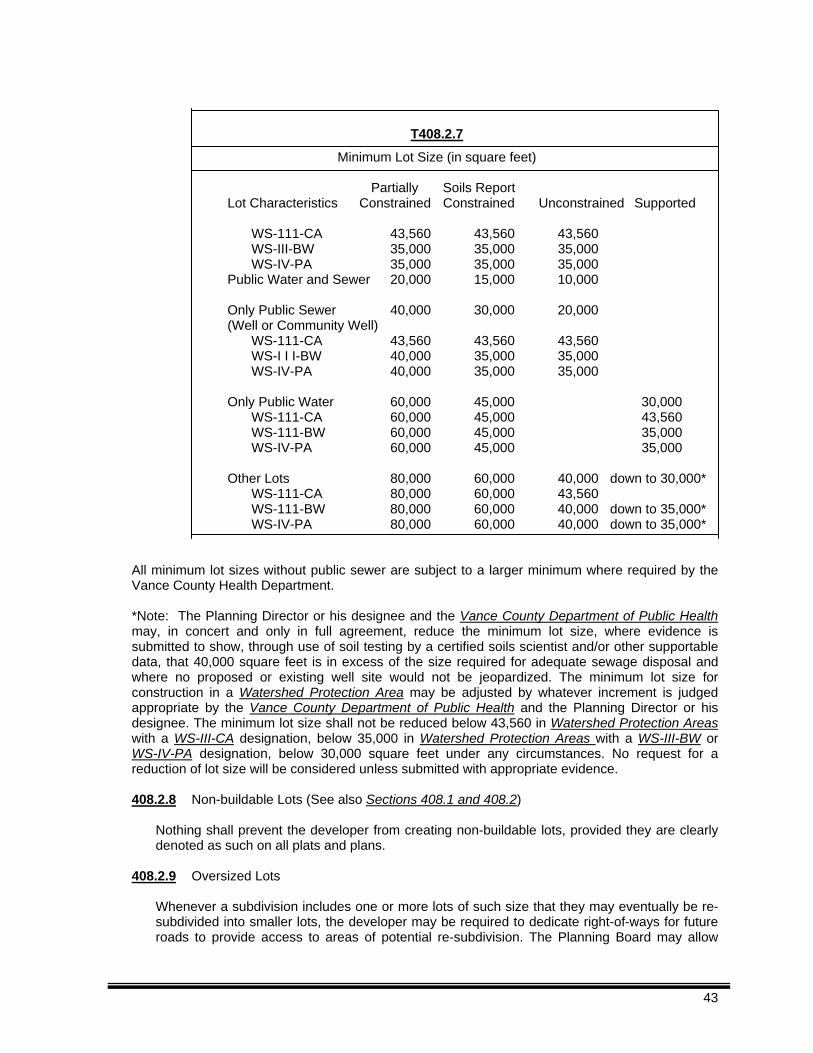
T408.2.7
Minimum Lot Size (in square feet)
Partially Soils Report Lot Characteristics Constrained Constrained Unconstrained Supported
WS-111-CA 43,560 43,560 43,560 WS-III-BW 35,000 35,000 35,000 WS-IV-PA 35,000 35,000 35,000
Public Water and Sewer 20,000 15,000 10,000
Only Public Sewer 40,000 30,000 20,000 (Well or Community Well)
WS-111-CA 43,560 43,560 43,560 WS-I I I-BW 40,000 35,000 35,000 WS-IV-PA 40,000 35,000 35,000
Only Public Water 60,000 45,000 30,000
WS-111-CA 60,000 45,000 43,560 WS-111-BW 60,000 45,000 35,000 WS-IV-PA 60,000 45,000 35,000
Other Lots 80,000 60,000 40,000 down to 30,000*
WS-111-CA 80,000 60,000 43,560 WS-111-BW 80,000 60,000 40,000 down to 35,000* WS-IV-PA 80,000 60,000 40,000 down to 35,000*
All minimum lot sizes without public sewer are subject to a larger minimum where required by the Vance County Health Department. *Note: The Planning Director or his designee and the Vance County Department of Public Health may, in concert and only in full agreement, reduce the minimum lot size, where evidence is submitted to show, through use of soil testing by a certified soils scientist and/or other supportable data, that 40,000 square feet is in excess of the size required for adequate sewage disposal and where no proposed or existing well site would not be jeopardized. The minimum lot size for construction in a Watershed Protection Area may be adjusted by whatever increment is judged appropriate by the Vance County Department of Public Health and the Planning Director or his designee. The minimum lot size shall not be reduced below 43,560 in Watershed Protection Areas with a WS-III-CA designation, below 35,000 in Watershed Protection Areas with a WS-III-BW or WS-IV-PA designation, below 30,000 square feet under any circumstances. No request for a reduction of lot size will be considered unless submitted with appropriate evidence.
408.2.8 Non-buildable Lots (See also Sections 408.1 and 408.2)
Nothing shall prevent the developer from creating non-buildable lots, provided they are clearly denoted as such on all plats and plans.
408.2.9 Oversized Lots
Whenever a subdivision includes one or more lots of such size that they may eventually be re-subdivided into smaller lots, the developer may be required to dedicate right-of-ways for future roads to provide access to areas of potential re-subdivision. The Planning Board may allow
43
such dedication to be waived where irreversible deed restrictions prohibiting such re-subdivision have been or will be recorded with the final plat.
408.2.10 Access to Lots and Driveways
408.2.10.1 All driveways and driveway entrances shall conform to the NCDOT “Policy on Street and Driveway access to NC Highways” for that portion within the public right-of-way. 408.2.10.2 Driveways and driveway entrances onto approved private roads or private access easements shall require Vance County Planning approval. 408.2.10.3 No lot shall be created that is landlocked or that does not have permanent ingress or egress to the property. 408.2.10.4 Adequate access shall be provided to each lot, with a minimum driveway entrance width of twenty (20) feet unless more is deemed necessary because of topographical conditions or street curvature. 408.2.10.5 There shall be a minimum of 20 feet between driveways except that two properties may share a driveway centered on the shared property line. 408.2.10.6 Development permits for a lot shall not be issued without ingress and egress shown on the plot plan and verification that vehicles shall be able to exit going forward. No occupancy permit shall be issued until such approved ingress and egress is constructed and operational.
408.2.10.7 Driveways crossing known flood hazard areas shall be elevated to or above the 100 year flood plain. Lots with driveways located within a Special Flood Hazard Area shall, prior to obtaining any development permits, make provisions for access to the property during times of flooding, prior to obtaining any development permits. 408.2.10.8 The size of driveway culverts allowed shall be based on calculation of the amount and velocity of flow of storm water in the channel. The minimum diameter shall be 15 inches. The ponding of additional storm water in a right-of-way, on individual property or the diversion of additional storm water to an adjoining property is expressly prohibited.
Section 409
Blocks
409.1 Blocks: Where used or appropriate, the lengths, widths and shapes of blocks shall be determined with due regard to:
a) Provision of adequate building sites suitable to the special needs of the type of use contemplated;
b) Zoning requirements;
c) Needs for vehicular and pedestrian circulation;
d) Control and safety of street traffic;
e) Limitations and opportunities of topography; and
f) Convenient access to water areas.
409.2 Length: Blocks shall not be more than 1,320 feet in length.
409.3 Width: shall have sufficient width to allow two (2) tiers of lots of minimum depth except:
44
a) Where single tier lots are required to separate the subdivision from a street or road,
b) In nonresidential subdivisions for purposes of separating uses, or
c) Where abutting a water area.
409.4 Crosswalks: Where deemed necessary by the Planning Board, a pedestrian crosswalk at least fifteen (15) feet in width may be required to provide convenient public access to a public area such as:
a) A park or school,
b) A water area, or
c) Areas such as shopping centers, religious or transportation facilities.
Section 410 Easements
Easements shall be provided as follows:
410.1 Utility Easements: Easements for underground utilities shall be centered on rear or side lot
lines.
410.2 Drainage Easements: Where a subdivision is traversed by a stream or drainage way, an easement shall be provided conforming with the lines of such stream and shall be of sufficient width as will be adequate for the purpose.
410.3 Floodplain Easement: Where a portion of a subdivision is located in a floodplain, said
floodplain shall be clearly designated on the plat in compliance with required "Flood Easement" statement listed in the Planning Department Policies and Procedures.
Section 411
Minimum Setbacks
410.1 Sewage Facilities: All sewage facilities shall be located one hundred (100) feet from any existing well or proposed new well.
410.2 Private Road Setbacks: Minimum Setback from Private Roads and Private Access
Easements. All buildings and principal uses shall have a setback of not less than twenty (20) feet from the right-of-way line of any private road or private access easement.
410.3 Public Road Setbacks: Minimum Setback from Public Roads. All lots in areas of Vance
County that are un-zoned shall have a minimum setback for all buildings and principal uses on a lot measured from the existing or proposed road right-of-way, or future expected road right-of-way for Major Thoroughfares, as follows:
a) Thirty (30) feet for a road with a posted speed of 35 mph or less,
b) Forty (40) feet for a road with a posted speed of 45 mph,
c) Fifty (50) feet for a road having a posted speed above 45 mph, and
d) Fifty (50) feet for a road not having a posted speed. 410.4 Minimum Setback Property Lines: All lots shall provide a building setback of twenty (20) feet
from all property lines other than an existing or future road right-of-way line.
45
Section 412 Parking
412.1 Parking: The purpose of this section is to provide for adequate off street parking for single
family residential developments and to maintain all roadways and entrances free of impediments to traffic.
412.1.1 Each lot within the subdivision shall be of adequate shape and size to provide a minimum
of two on-site parking spaces for each dwelling unit on the lot. Each parking space shall have a minimum size of nine (9) feet by nineteen (19) feet for the exclusive use of residents and visitors of that lot.
412.1.2 No parking shall be provided for on private roads or at the entrances to subdivisions
unless additional paved width to the road has been approved expressly for this purpose by the Planning Board and/or NCDOT as appropriate.
Section 413
Residential Fencing and Walls
413.1 Residential Fencing: Except as otherwise noted in this Ordinance, fences or yard walls are permitted subject to the following regulations:
a) Barbed wire, razor wire or concertina wire is specifically not permitted.
b) No fencing or walls shall be allowed in the road right-of-way or in areas required for vehicular
sight distance.
Section 414 Naming of a Development:
414.1 Names: New Development names shall not duplicate or closely approximate the names of
existing or reserved subdivisions, apartment complexes, mobile home parks, roads, lanes, drives or street, within the County, within municipalities in the County, or in adjoining counties within one mile of Vance County. Naming of a Development shall be subject to approval by the Vance County Board of Commissioners.
Section 415
Identification Sign Allowed: 415.1 Size Specifications: A sign not exceeding thirty-two (32) square feet in area and six (6) feet in
height with indirect lighting shall be permitted. No animated, flashing, or moving signs will be permitted. The sign must be clearly legible from 150 feet and shall not incorporate script in lieu of numbers. If illuminated, signs parallel to the road shall be lighted from the front side only and if perpendicular may be lighted from both sides. No lighting shall be directed toward the road.
415.2 Sign Maintenance: Provisions for the maintenance of an identification sign, lighting
equipment, and landscaping shall be included in Home Owners Association Documents (See Section 419) and submitted as part of the for approval of a subdivision.
415.3 DOT Standards: All Subdivision Identification Signs shall also conform to the NCDOT
Subdivision Roads, Minimum Construction Standards.
“The Division of Highways will review requests to erect subdivision name markers on an individual basis. The name markers may be allowed to be located within the State Highway
46
System Secondary Road Rights-of-Way at the beginning of a subdivision road, provided the location of such is outside the line of sight and the normal maintenance limits. The name markers will be approved only at locations which will not sacrifice safety to the general traveling public. Approval to erect subdivision name markers will be with the following understanding:"
a) All costs will be the responsibility of the requestor
b) The North Carolina Division of Highways will not maintain the marker or the area around the marker.
c) The markers will be removed if not properly maintained.
d) The Division Engineer may allow the subdivision name markers on secondary road rights of way after review on an individual basis.
Section 416 Other Signs
414.1 Other Signs: No signs shall be allowed in a road right-of-way or safe sight distances, except
those approved by the North Carolina Department of Transportation and Vance County. No billboards or other off-site signs shall be permitted in a subdivision which would impair the delivery of emergency services, block house numbers, block street naming signs, block traffic control signage, or impair traffic visibility.
Section 417
911 Address Number Required To Be Posted 417.1 911 Address: Each lot shall be clearly numbered with 4" letters on a contrasting background
on a permanent monument or marker at the intersection of the front yard line and the road ROW. The house number shall be readily identifiable by emergency personnel. The use of script in lieu of numeric characters is specifically prohibited.
417.2 Temporary Address Signs: An all-weather temporary sign, visible from the road at all times,
may be used. The developer shall be responsible for maintaining the numbering on the lot until final occupancy is granted.
417.2.1 Each structure within a subdivision shall be clearly numbered on the structure. 417.2.2 No structure within a subdivision may be occupied until the provisions in Section 417.1
have been met. 417.2.3 The owner shall be responsible for maintaining the numbering on the structure and the
monument or marker. 417.2.4 All mail receptacles shall have the structure or dwelling numbers posted with two (2) inch
letters on a contrasting background. The use of script in lieu of numeric characters is specifically prohibited. Maintenance shall be the responsibility of the homeowner.
Section 418 Cemeteries
418.1 Cemeteries: A subdivision shall provide permanent public access to any existing cemetery within the boundaries of the subdivision.
If there is no other access, any existing cemetery located on land adjacent to a proposed subdivision must be provided adequate access.
47
Section 419 Home Owner’s Associations
419.1 Establishment of Owner's Association
419.1.1 Creation: An Owner's Association shall be established in compliance with the North
Carolina Condominium Act or to accept conveyance and maintenance of common areas and facilities within a development.
419.1.2 Conveyance: All common areas or facilities, except right-of-ways and other areas
dedicated to the jurisdiction, shall be conveyed by the subdivider or developer to the Owner's Association.
419.1.3 Subdivision or Conveyance of Common Area: Common areas shall not be subdivided or
conveyed to the Owners Association unless a revised plat is submitted to and approved by the Planning Board.
419.1.4 Owner's Association Not Required: Developments involving only two (2) units attached
by a party wall shall be permitted to have an owners agreement in lieu of a home owner’s association concerning the maintenance of the party wall.
419.2 Submission of Owner's Association Declaration: A copy of proposed by-laws covering
covenants and restraints shall be submitted with the final plat prior to approval.
419.2.1 Existence Before Any Conveyance: The Owner’s Association declaration shall be organized and in legal existence prior to the conveyance, lease-option, or other long-term transfer of control of any unit or lot in the development.
419.2.2 Membership: Membership in the Owner's Association shall be mandatory for each
original purchaser and each successive purchaser of a lot or unit. Provisions shall be made for the assimilation of owners in subsequent sections of the development.
419.2.3 Owner's Association Declaration: The Owner’s Association declaration shall contain the
following items:
419.2.3.1 Responsibilities of Owner’s Association. The Owner’s Association declaration shall state that the association is responsible for:
a) The payment of premiums for liability insurance and local taxes, b) Maintenance of recreational and/or other facilities located on the common areas,
and
c) Payment of assessments for public and private improvements made to or for the benefit of the common areas
419.2.3.2 Default of Owner's Association:
In the event of failure of the Owner's Association to pay jurisdictional assessments for public improvements or ad valorem taxes levied against the common areas with the default continuing for six (6) months or more, each individual owner shall be personally obligated to pay his or her portion of the due amount. The amount due, determined by dividing the number of lots into the amount owed, shall be paid within thirty (30) days following receipt of notice. Failure of the owner to pay the amount due, his or her heirs, devisees, personal
48
representatives or assigns to, shall result in a property lien on his or her parcel and may result in foreclosure of the lien against the owner's property.
419.2.3.3 Powers of the Association
Failure of a property owner, subject to the owner's association to pay expenses due, shall constitute a lien on the property.
419.2.3.4 Easements and rights of access and use.
Easements over the common areas for access, ingress, and egress from and to public streets and walkways and easements for enjoyment of the common areas, and for parking, shall be granted to each lot owner.
419.2.3.5 Maintenance and Restoration
The owner's association shall establish and adopt provisions for common area maintenance and restoration in the event of destruction or damage.
Section 420 Boat Docks
Subdivisions with access allowed by the US Corps of Engineer on Kerr Lake shall have at least one (1) dedicated roadway to the lake for use by all owners within the subdivision. Construction and maintenance shall comply with USCOE requirements and shall minimize the disturbance to existing shoreline and adjacent lands. The use of high wattage spotlights, flashing lights, or other intrusive lighting system is expressly prohibited. No straight pipe restroom facilities may be constructed in conjunction with any development on land adjoining the Kerr Lake.
Section 421 Construction Assurances for Minor Subdivisions
421.1 Refer to Article Six (6) for construction assurance requirements.
Section 422
Minor Subdivision Application Forms & Requirements
422.1 Forms & Requirements: Check lists, forms, certifications, statements, construction plan requirements and applications for minor subdivisions are listed in the policies and procedures document for the Vance County Planning and Development
49
Article Five For Major Subdivisions
Section 501
Purpose
The purpose of this Article is to establish procedures for orderly review, processing and action on major subdivisions.
Section 502
General 501.1 Review of Revisions & Changes: The Vance County Planning Board has the right and
responsibility to review, require revisions and changes in any proposed subdivision for the purpose of:
a) Relieve adverse impacts on public safety, health and welfare; b) Determine that adequate and sustainable utilities and services are available for the
development; c) Protect public investments in roads, drainage facilities, sewage facilities, public water
supplies; d) Preserve the value of land and development; and e) Assure that the regulations of Vance County are upheld.
Section 503
Approval Required
503.1 Approval of Permits: No permits for construction, clearing, or grading of any new or expansion of existing subdivisions shall be issued until a subdivision plat has been submitted, reviewed and approved per the requirements of this Ordinance.
Section 504
Pre-Submittal Conference and Concept Plan Submittal and Review 503.1 Pre-Submittal Conference: A developer may request a "pre-submittal" conference with the
Planning Department and/or Technical Review Committee regarding the development of a proposed subdivision.
Section 505 Completion of Development in Phases
505.1 Phased Development: A subdivision may be developed in phases provided that:
505.1.1 Each phase contains at least six (6) lots, unless shown on a phasing plan approved by the Planning Board as part of the preliminary subdivision plan.
505.1.2 A phasing plan showing the phases of development and the requirements of this
Ordinance that will be satisfied in each phase is either approved as part of the preliminary plan or in conjunction with approvals of both the construction plat and final plat;
505.1.3 The number of lots and amount of any required open space in the phase and any
previously approved phases is at least proportional to the portion of the subdivision site area within the phase(s); and
50
505.1.4 The degree and extent of road, water supply, sewage disposal, storm water management, erosion and sedimentation control, and other required improvements in the phase and previously approved phases is sufficient to serve or handle all development within the phase(s).
Section 506
Subdivision Application Forms and Additional Information Requirements
The following items are presented in checklist form and constitute the application requirements for: (see Policies and Procedures)
506.1 Conceptual Plan Checklist
506.2 Major Subdivision
a) Preliminary Plat Checklist b) Construction Plan Checklist c) Final Plat Checklist d) Required Certification Statements
Section 507
Improvements, Dedications, Easements and Minimum Standards of Design Required
Each subdivision shall contain the improvements specified in this article, which shall be installed in accordance with the requirements of this ordinance. Land shall be dedicated, reserved or easements provided in each subdivision as specified in this article.
Article Six Bonds & Assurances
Section 601
Construction Assurances
In the event that the required improvements have not been completed prior to: 601.1 The submission to the Planning Board of the final plat for a major subdivision, or 601.2 The submission of a minor subdivision plat for signature and recording. The developer shall
guarantee the completion of the required improvements in an amount equal to one hundred and fifty (150) percent of the estimated cost of the improvements, conditional upon completion within a reasonable period of time and to the satisfaction of the Board of County Commissioners.
601.3 One of the following methods may be pursued by the developer to ensure the installation of
said improvements:
601.3.1 Filing a performance or surety bond in an amount approved by the Board of County Commissioners; or
51
601.3.2 Depositing or placing in escrow a certified check or cash in an amount satisfactory to the Board of County Commissioners; or 601.3.3 Furnishing an irrevocable letter of credit guaranteeing payment to Vance County in the event of default 601.3.4 Neither a bond, irrevocable letter of credit, nor certified check in escrow shall be required if the developer proves that he has paid the utility company(s) the amount of money needed to install the utilities; in a timely manner.
601.3.5 Neither a bond, irrevocable letter of credit, nor certified check in escrow shall be required of the developer if the utility company(s) state in writing that the utilities will be installed at no cost to the developer nor new lot owner(s).
601.4 Release of Assurance: When the required improvements have been completed to the
satisfaction of the appropriate agencies and the subdivision ordinance, the Planning Director shall make a request in writing to the County Manager to release the bond, letter of credit or funds from escrow.
601.5 Final Approval: The approval of a final plat pursuant to regulations adopted herein shall not be
deemed to constitute or effect the acceptance by the County, any governmental unit or public body of the dedication of any street or other ground, public utility line, or other public facility shown on the plat.
Article Seven
Word Usage & Definitions
Section 701 Usage
701.1 Usage: Unless the context clearly indicates to the contrary, words used in the present tense include the future
tense and words used in the singular include the plural. In general, words and terms used in these standards shall have their customary dictionary meanings;
except as defined in the following section or unless they are used in context so as to indicate otherwise.
Section 702 Definitions
702.1 Meaning of Common Words:
a) All words used in the present tense include future tense.
b) All words used in the plural include the singular, and all words used in the singular include the plural.
c) All words used in the masculine gender include the feminine gender.
d) The words "shall" or "will" are mandatory, and the word "may" is permissive.
e) The word "building" includes the word "structure".
f) The word "lot" includes the words "plot", "parcel", and "tract".
52
g) The word "person" includes a "firm”, "association", "organization", "partnership", "trust", "company", or “corporation" as well as an "individual".
702.2 Words and Terms Defined:
For the purpose of this Ordinance, certain terms or words used herein shall be defined as follows:
Abutting Property: For public notice purposes, any lot which is physically contiguous with the lot in question, even if only at a point, and any lot which is located directly across a street or right-of-way. Also see adjoining, adjacent, or contiguous. Access Easement: An easement which grants the right to cross property. (See also Private Access Easement). Balance Area (Watershed) Area of Watershed other than Critical Area. Building: Any structure having a roof supported by walls or columns constructed or used for a residence, business, industry or other private or public purposes. Built Upon Area: Built upon areas shall include that portion of a development project that is covered by impervious or partially impervious cover including buildings, pavement, gravel roads, recreation facilities (e.g. tennis courts), etc. (Note: wooden slatted decks and the water area of a swimming pool are considered pervious.) Construction Assurance: A financial instrument that guarantees to the County that the public improvements required to be constructed as part of an approved subdivision will either be constructed by the subdivision developer or that the County shall have sufficient funds in the form of a financial instrument to complete the required public improvements if the subdivision developer does not. Construction Drawings (Plans): Drawings showing the location, profile grades, size and type of drains, sewers, water mains, underground fire alarm ducts, underground power ducts, and underground telephone ducts, pavements, cross-section of streets, miscellaneous structures, etc. Contiguous Lot: For the purposes of these regulations, a lot shall be considered to be contiguous with another lot if the lot adjoins or is coterminous with another lot at any point or line. County: Refers to Vance County, North Carolina. Critical Area (Watershed): That area located within one-half (1/2) mile of and draining to water supplies as measured from the normal pool elevation of reservoirs, or one-half (1/2) and draining to a river intake. Dedication: A gift, by the owner, of his property to another party without any consideration being given for the transfer. The dedication is made by written instrument and is completed with an acceptance. Developer: Any person, firm, trust, partnership, association or corporation engaged in development, or proposed development of a subdivision. Development: Any man-made change to improved or unimproved real estate, including, but not limited to, buildings or other structures, mining, dredging, filling, grading, paving, excavations, or drilling operations or storage of equipment or materials. Development Permit: A document issued by the Planning department for an individual lot, which identifies ownership, geographical information, physical attributes (size and configuration), source
53
of water, method of sewage disposal, road access information, existing improvements, and proposed improvements. This document specifies the conditions under which proposed improvements can occur. Development Plan: (Reserved) Driveway: A private entrance from a road or right-of-way to a lot, building, or buildings on same or abutting grounds. The driveway itself shall not constitute the means of legal access to a lot. Easement: A grant of one or more property rights, by the property owner, to, or for use by, another, the public, a corporation, or other entities. The authorization of a property owner for the use by another, for a specified purpose, of any designated part of his property. Engineer: Professional Engineer licensed by the State of North Carolina. Floodplain: Area designated by FEMA as one (1) percent (flood danger is one (1) year in one-hundred (100) years) and as five (5) percent (flood danger is one (1) year in five-hundred (500) years) Impervious Surface: A surface composed of any material that impedes or prevents natural infiltration of water into the soil. Lot, Buildable or zone lot: One or more lots of record in one undivided ownership with sufficient total area, exclusive of easements, flood hazards, well and septic tank fields; sufficient total dimensions; and access to permit construction thereon of a principal building together with its required parking and planting yards. Lot: A portion of a subdivision or any other parcel of land intended as a unit for transfer of ownership, or for development or both. The word "lot" includes "plot," "parcel," or "tract."
Lot Corner: A lot abutting two (2) or more streets at their intersection.
Lot Depth: The distance measured along the perpendicular bisector of the smallest possible rectangle enclosing the lot.
Lot Width: The mean width measured at right angles to its depth at the building line. Lot(s), Constrained: A lot on which one or more of the following characteristics are present on over
fifty (50%) percent of the lot:
a) Slopes over twenty (20%) percent;
b) Soils with a plasticity index greater than forty eight (48); or with rock within three (3) feet of the surface; or with water table within one (1)foot of surface;
c) Floodway or floodplain of the FEMA one hundred (100) year flood of record;
d) Wetlands;
e) Water Supply Watershed Protection Area Lot(s), Partially Constrained: A lot on which one or more of the following characteristics are present on more than twenty-five percent (25%) of the lot but less than fifty (50%) percent of the lot:
a) Slopes over twenty (20%) percent;
b) Soils with plasticity. index greater than forty eight (48); or with rock within three (3) feet of the surface; or with water table within one (1)foot of surface;
c) Floodway or floodplain of the FEMA one hundred (100) year flood of record;
d) Wetlands;
54
e) Water Supply Watershed Protection Area
Lot of Record: A lot, plot, parcel, or tract recorded in the Office of the Register of Deeds in conformance with the ordinance(s) in effect at the time of recordation. Memorandum of Understanding: A written document prepared by the Subdivision Administrator after the Technical Review Board makes a recommendation to the Planning Board on a Preliminary Subdivision Plat. This document shall contain a record of those modifications to the application that the applicant or the applicant’s agent has agreed to at the Technical Review Board meeting and any further approval conditions or reasons for recommending denial of the application acted upon by the Technical Review Committee. Net Lot Area: The area of a lot not containing public road rights-of-way, private road rights-of-way, private or public access easements or other similar easements which do not allow use of the land for other purposes (such as the location of a house or septic drainage field, etc.). Non-conforming lot: A lot which is now prohibited under the terms of this Ordinance, but was lawful at the date of this Ordinance's enactment, or any amendment or revision thereto. New Private Road; Construction of a vehicular right-of-way and street or road where no road currently exist and not intended for dedication to or maintenance by NCDOT or other appropriate public agency. Owner: Any holder of any legal or equitable estate in the premises, whether alone or jointly with others, and whether in possession or not. Person: The term “person” includes a firm, association, organization, partnership, trust, company, limited liability company, or corporation, as well as an individual. Planning Board: The Planning Board of Vance County. Planning Department: The Planning Department of Vance County. Plot Plan: A plan of an individual lot, prepared to a scale (1”=40’ through 1”=100’), showing the following information accurately with dimensioning:
a) the boundaries of a site,
b) minimum building setback lines,
c) the location of all buildings, structures and uses,
d) the location of proposed driveways and on-site vehicle storage and turnaround facilities, and
e) the proposed location any wells and septic fields including primary repair/replacement fields.
Principal Building or Principal Structure: A building or structure in which is conducted the principal use of the lot on which it is located. Any dwelling is considered a principal building. Private Access Easement: A vehicular right-of-way granted and recorded with the Register of Deeds providing for permanent ingress and egress across one lot to another on which the owner(s) of the property containing the easement shall not erect any temporary or permanent structures other than those structures necessary for management of storm water drainage. Private Road: A vehicular right-of-way and street or road not intended for dedication to or maintenance by NCDOT or other appropriate public agency.
55
Protected Area (Watershed) That area located within five (5) miles and draining to water supplies as measured from the normal pool elevation of reservoirs, or ten (10) miles upstream of and draining to a river intake. However, in some cases the Protected Area can encompass the entire drainage area. Public Road. A dedicated public right-of-way for vehicular traffic which 1) has been accepted by NCDOT for maintenance; or 2) is not yet accepted, but in which the roadway design and construction have been approved under public standards for vehicular traffic. Alleys are specifically excluded. Public Sewer: A system which provides for the collection and treatment of sanitary sewage from more than one property and is owned and operated by a government organization or sanitary district. Public Water: A system which provides distribution of potable water for more than one property and is owned and operated by a government organization or utility district. Register of Deeds: Vance County Register of Deeds. Reservation: Reservation of land does not involve any transfer of property rights. It constitutes an obligation to keep property free from development for a stated period of time. Re-subdivision: The division of an existing subdivision or any change of lot size therein or the relocation of any street or lot in a subdivision. Right-of-Way: A strip of land occupied or intended to be occupied by a travelway for vehicles and also available, with the consent of the appropriate governmental agency, for installation and maintenance of sidewalks, traffic control devices, traffic signs, street name signs, historical marker signs, water lines, sanitary sewer lines, storm sewer lines, gas lines, power lines, and communication lines. Road / Street: For the purposes of this ordinance, the words “road” and “street” shall have the same meaning and are interchangeable. Setback. The horizontal distance between a structure or activity and a property line, road right-of-way line, or road centerline should the centerline of a road right-of-way be used to measure minimum required setbacks.
Front or Street Setback. A line parallel to the street in front of which no structure shall be erected.
Interior Setback. A setback from any property line not alongside a street.
Rear Setback. A setback from an interior property line lying on the opposite side of the lot from the front or street setback.
Side Setback. Any interior property line setback other than a rear setback. Shall: When used in this ordinance, it is intended to indicate a mandatory requirement. Sight Distance Easement: An easement which grants to the appropriate government body or agency the right to maintain unobstructed view across property located at a street or lane intersection. Slope: An inclined ground surface, the inclination of which is expressed as a ratio of horizontal distance to vertical distance, commonly expressed as "two to one", (2:1).
56
Soil Scientist: A person who practices soil science and is licensed in accordance with the North Carolina General Statutes. Solid Waste: Garbage, refuse and other discarded solid materials. Structure: Anything constructed, erected, or placed. Subdivider: Any person, firm, corporation or official agent thereof, who subdivides or develops any land deemed to be a subdivision. Subdivision: For purposes of this ordinance, the term subdivision shall mean the division of a tract or parcel of land into two (2) or more lots, building sites, or other divisions for the purpose of sale or building development (whether immediate or future), and includes all division of land involving the dedication of a new street or a change in existing streets; however, the following are not included within this definition and are not subject to any subdivision approval regulations in this Ordinance:
a) The combination or recombination of a portion of previously subdivided and recorded lots if
the total number of lots is not increased, and the resultant lots are equal to or exceed the standards of this Ordinance;
b) The division of land into parcels greater than ten (10) acres if not street right-of-way
dedication is involved; c) The public acquisition by purchase of strips of land for the widening or opening of streets;
and d) The division of a tract in single ownership, the entire area of which is not greater than two
(2) acres, into not more than three (3) lots, if no street right-of-way dedication is involved, and if the resultant lots are equal to or exceed the standards of this Ordinance.
Subdivision, Major: Any subdivision other than a minor subdivision, including all subdivisions of land for which a non-residential use is proposed. Minor Subdivision – A subdivision pursuant to this Chapter to be used only for single family detached residential uses where the lots may have access to:
a) An existing public road, or b) An existing private road, or c) A proposed Class 1 Private Road, or d) A proposed Class 2 Private Road (accessed by seven[7] or fewer lots), or e) A private access easement (accessed by four [4] or fewer lots).
(See definition of Private Road and Private Access Easement and Section 318.C for standards).
and where the proposed subdivision does not:
f) create more than seven (7) lots [six new lots] from any one tract of land, whether such lots
are created at one time or over an extended period of time, regardless of changes in ownership; and
g) Dedicate or improve any new public roads; and h) Adversely affect the development potential of the remainder of the parcel or of adjoining
property by virtue of unreasonably limiting access or limiting adequate drainage, and
57
i) preclude reasonable access to the remainder of the tract of land being subdivided via the future use of a 60 feet wide public or private street, [25 ft. if 60 ft. is not available], and
j) Preclude safe public or private road access to adjoining tracts of land, and k) Propose lots entirely or substantially located in a flood hazard area as defined by Vance
County Ordinance 29, Flood Damage Prevention Ordinance. (This ordinance may be obtained at the Vance County Planning Department or the Vance County Clerk’s office.)
Subdivision Plat, Minor: The drawings on which a plan of a minor subdivision is presented to the Vance County Planning Board for approval and which, if approved, shall be filed for recording with the Vance County Register of Deeds.
Subdivision Plat, Preliminary: The preliminary drawings indicating all existing conditions relating to a site and a plan prepared in accordance this Ordinance. Sufficient detail and sufficient accuracy shall be used in the preparation of the plan of the existing physical characteristics of the project property, the proposed changes in those characteristics, or proposed uses of the project property to enable a full and comprehensive review of the proposed development and the proposed layout of the subdivision to be submitted to the Planning Board for its consideration. Subdivision Plat, Final: The final drawings on which a plan of subdivision is presented to the Vance County Planning Board for approval and which, if approved, shall be filed for recording with the Vance County Register of Deeds. The fully executed, signed Final Plat shall be filed in Register of Deeds Office within Sixty (60) days of the date of approval in order to retain approval status. Subdivision Administrator: The Vance County Planning Director Subdivision Review Officer: Reserved Thoroughfare Plan for Vance County: A systematic study of the Thoroughfare Road System in Vance County which identifies existing and future deficiencies in the road system and identifies the need for any new facilities. These needs and deficiencies are then brought forward as projects to be placed before the North Carolina Department of Transportation for funding consideration. If the deficiency or need is recognized as a priority it will be included in the five year Transportation Improvement Plan and scheduled for State funding. Projects not identified in the Thoroughfare Plan are not considered for funding. Tract or Parcel of Land: All contiguous land and bodies of water in one ownership, or contiguous land and bodies of water in diverse ownership, being developed as a unit, although not necessarily all at one time. Use: The purpose or activity for which land or structures is designed, arranged or intended, or for which land or structures are occupied or maintained. Utility Easement: An easement that grants the Governing Body or other utility providers the right to install and thereafter maintain any and all utilities including, but not limited to, water lines, sewer lines, septic tank drain fields, storm sewer lines, electrical power lines, telephone lines, natural gas lines and community antenna television systems. Vance County Public and Private Road System - Functional Classification: The following are functional classifications used to determine design speed, right-of-way width, sight distance, access policy, and other design and development criteria.
A. Interstate Highways (I-85)
B. Major Thoroughfares include the following categories
58
59
1. Arterial Roads
a) Principal Arterial. Serves primarily substantial statewide or interstate travel. This system consists of all non-Interstate principal arterial roads. (typical speeds of 55 mph or higher)
b) Minor Arterial. Serves primarily through traffic movements in the County(typical speeds of 45-55 mph)
2. Collector Roads
a) Major Collector. Serves primarily intra-county travel. The major collectors supplement the arterial system by providing an interconnecting network between smaller population centers and the arterial system. (typical speeds of 45-55 mph)
b) Minor Collector. Collects traffic from local roads and brings all developed areas within reasonable distance of a collector road.(typical speeds of 45-55 mph)
c) Unclassified collectors. All major or minor collectors that have not yet been assigned a functional classification.(typical speeds of 45-55 mph)
C. Minor Thoroughfares – Local Roads
1. Residential Subdivision Road. A road which serves primarily to provide access to abutting property, over relatively short distances. (Typical speeds of 25-30 mph.)
2. Residential Collector Road. A road which serves as the connecting system between local residential subdivision roads and collectors, but which also may provide direct access to abutting properties. (Typical speeds of 25-35 mph)
3. Subdivision Access Road. A road built through vacant property to provide access to a subdivision. This road would not have lots platted along it.(See Section 412.C Private Roads for application)
Vested Right: Reserved
Waiver: Permission to depart from the literal requirements of this Ordinance, when in the Opinion of the Planning Boar, the literal application of the requirements of this Ordinance create an undue hardship on the owner of the property and where the public health, safety, and welfare interest of the public can be served as well or better by alternative means.
Watershed: The entire land area contributing surface drainage to specific point (e.g. the water supply intake.)