
Request for Plat Abandonment for the Kayenta Estates Minor Subdivision (S-06-02)
Subdivision Development
Preliminary Plat Application Information & Procedures
Copies of this and other Development Packet Chapters are available online at: https://www.roundrocktexas.gov/departments/planning-and-development-services/land-
development-permits/
Contents:
Page Item
2. Preliminary Plat Review Flow Chart
3. Preliminary Plat Review Process
4. Deadlines & Meeting DatesSubdivision Ordinance and Design & Construction StandardsPresubmittal Meeting
5. Presubmittal Meeting Request Form
6. Preliminary Plat – Application Requirements
8. Preliminary Plat – Required Plat Content
12. Project Application
14. Affidavit of Ownership
15. Letter of Intent for Parkland Conveyance
16. Park Zone Map
17. Planning & Zoning Commission (P&Z) Schedule
18. Staff Contacts
Planning and Development Services Department City of Round Rock, Texas
Updated November 08, 2019
Pre-submittal
Meeting
TIA Approval,
Deferral, or Waiver
Letter
Application
Submittal
Application
Complete?City & Agency
Staff Review
Staff Recommends
P&Z Approval
Comments Issued
to ApplicantApplication
Complies with
Ordinances &
Plans?
City & Agency
Staff Review
of Update
Review
Comments
Addressed?
Applicant Cannot
Resolve Outstanding
Comments Before
Commission Meeting
Staff Recommends
Conditional P&Z
Approval
New Application
Applicant Submits
Extension Request
Proceed to
Final Plat
Applicant Will
Resubmit
Staff Recommends
P&Z Approval
Preliminary PlatApplication Process
No
Yes
No
Yes
Yes
Yes
No
No
No
Yes
P&Z Consideration
P&Z
Approval of
Application
P&Z
Approval of Extension
Request
Applicant Submits
Update or
Submits Extension
Request
Floodplain Study
Approval or Waiver
Letter
Rev. 08/23/19
Page 3
Preliminary Subdivision Plat
This section of the Development Packet consists of information and required forms for Subdivision Preliminary Plat applications.
The purpose of a Preliminary Plat is to present a detailed layout of the proposed subdivision in order to facilitate review by the Planning and Zoning Commission of the proposal’s street and drainage systems, easements, utilities, development lots, and other lots, including parkland.
The Applicant shall submit a Preliminary Plat application to Planning and Development Services (PDS) for approval by the Planning and Zoning Commission. The Preliminary Plat shall conform with the approved Concept Plan, if required.
If the proposed subdivision is outside City Limits and annexation is not proposed, please review the Platting in the ETJ section of the Subdivision Packet for additional County requirements.
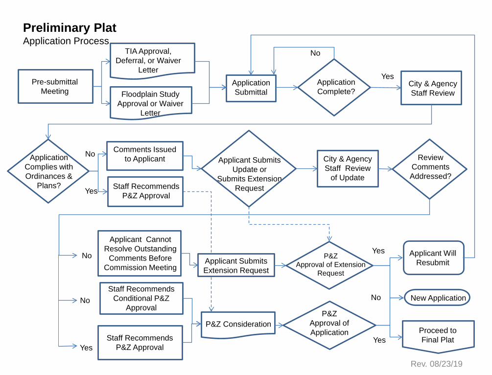
Preliminary Plat Review Process
An application is submitted on the Official Filing Date and reviewed for completeness (see attached Preliminary Plat Application Requirements). If the application is determined to be complete, it is distributed for technical and content review (see attached Preliminary Plat Content). Comments generated during that review are forwarded to the Applicant within 10 calendar days.
The Applicant has approximately one week to respond to comments. After the Applicant has completed the requested modifications or otherwise addressed review comments, an updated plat, specified number of paper copies, and supporting materials shall be submitted to PDS for distribution and review. If all review comments have been satisfied, staff shall recommend that the Planning and Zoning Commission approve the application. Preliminary plats do not require subsequent City Council approval.
After approval by the Planning and Zoning Commission, PDS staff will notify the Applicant of the Commission’s decision. If an application was conditionally approved, the Applicant shall either correct the original mylar submitted with the response to comments, or shall submit a reproducible corrected mylar and a specified number of paper copies to PDS, if applicable.
Any conditions of application approval and/or corrections to the Preliminary Plat must be satisfied prior to submittal of an associated Final Plat, or within 45 days of approval by the Planning and Zoning Commission, whichever occurs first.
Preliminary Plats shall expire two (2) years after approval unless a Final Plat for a portion of the Preliminary Plat has been approved and recorded, in which case the Preliminary Plat is extended three additional years from the date each additional final plat is recorded. If a Preliminary Plat expires, the associated Concept Plan shall also be deemed expired. Major revisions to a Preliminary Plat (see Part III Chapter 10, Article V, subsection 10-27(f)) require approval by the Planning and Zoning Commission and shall extend the Preliminary Plat for two (2) years from the date of Commission approval. A minor revision to a Preliminary Plat, that is administratively approved, does not extend the expiration date beyond the two (2) years from the original date of
Page 4
approval by the Planning and Zoning Commission, extensions for recorded Final Plats notwithstanding.
Deadlines and Meeting Dates
Applications for Preliminary Plats (whether original or revised) are reviewed on a schedule adopted by the Planning and Zoning Commission that reflects state statutory requirements. This schedule includes specific dates for application submittals to City staff and subsequent review by the Planning and Zoning Commission.
Review cycles usually begin on the 1st. and 3rd. Tuesday of each month. A Planning and Zoning Commission Submittal and Meeting Schedule is included in this chapter and is available online at
https://roundrock.legistar.com/Calendar.aspx
Subdivision Ordinance, Design & Construction Standards, & Other Requirements
Zoning and Development Code Standards This section of the Development Packet is intended to assist the Applicant in preparing a formal application. It does not replace the requirements found in the Code Of Ordinances, City of Round Rock, Part III, Zoning and Development Code, 2018, as amended. Please review applicable chapters of the Zoning and Development Code and adopted Standards prior to application submittal.
The Zoning and Development Code is available online at:
https://library.municode.com/tx/round_rock/codes/code_of_ordinances?nodeId=PTIIIZODECO
The Design and Construction Standards (DACS) are available online at:
https://www.roundrocktexas.gov/departments/transportation/dacs/
Requirements for a Traffic Impact Analysis, Parkland Conveyance, and Tree Protection & Mitigation shall be addressed at the Preliminary Plat stage if not addressed with a Concept Plan.
Presubmittal Meeting
Prior to submitting an application, the Applicant must schedule a presubmittal meeting with PDS to discuss the proposed development. A Presubmittal Meeting Request form is included in this packet and is also available online.
Please contact PDS (512) 218-5428 or [email protected] to schedule a presubmittal meeting for platting. Please forward items noted on the checklist to PDS five days in advance of the scheduled meeting to allow time for staff review and any associated research.
During or after the Presubmittal Meeting and before submitting an application, the Applicant must verify the deadline for filing an application with Planning and Development Services (PDS) and the date of the Planning and Zoning Commission meeting.
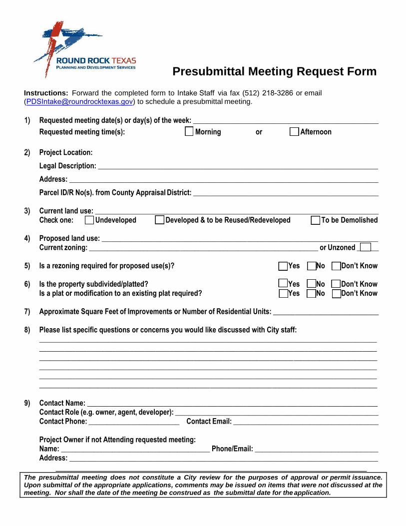
Presubmittal Meeting Request Form
Instructions: Forward the completed form to Intake Staff via fax (512) 218-3286 or email([email protected]) to schedule a presubmittal meeting.
1) Requested meeting date(s) or day(s) of the week: ___________________________________________________ Requested meeting time(s): Morning or Afternoon
2) Project Location:
Legal Description: _____________________________________________________________________________ Address: _____________________________________________________________________________________ Parcel ID/R No(s). from County Appraisal District: ___________________________________________________
3) Current land use: ______________________________________________________________________________ Check one: Undeveloped Developed & to be Reused/Redeveloped To be Demolished
1)
4) Proposed land use: ____________________________________________________________________________2) Current zoning: _______________________________________________________________ or Unzoned ______3)
5) 4) Is a rezoning required for proposed use(s)? 5) Yes No Don’t Know 6)
6) Is the property subdivided/platted?Is a plat or modification to an existing plat required?
Yes No Don’t Know Yes No Don’t Know
7) Approximate Square Feet of Improvements or Number of Residential Units: _____________________________
8) Please list specific questions or concerns you would like discussed with City staff:______________________________________________________________________________________________________________________________________________________________________________________________________________________________________________________________________________________________________________________________________________________________________________________________________________________________________________________________________________________________________________________________________________________________________________
9) Contact Name: ________________________________________________________________________________Contact Role (e.g. owner, agent, developer): ________________________________________________________Contact Phone: _________________________ Contact Email: ________________________________________
Project Owner if not Attending requested meeting:Name: _________________________________________ Phone/Email: __________________________________Address: _____________________________________________________________________________________
The presubmittal meeting does not constitute a City review for the purposes of approval or permit issuance. Upon submittal of the appropriate applications, comments may be issued on items that were not discussed at the meeting. Nor shall the date of the meeting be construed as the submittal date for the application.
Page 6
Preliminary Plat Application Requirements
▪ Please note that Preliminary Plat Applications must be submitted in person by the Applicant or Applicant’s agent. Applications submitted by a delivery service will NOT be accepted.
▪ Please note that the Preliminary Plat will NOT be considered complete or filed unless all the application requirements are met.
The Applicant shall submit a Preliminary Plat application that contains 1 paper and 1 digital copy of the
following, unless otherwise noted:
paper pdf
___ ___ 1. Completed Project Application (included in the following pages of this packet);
___ ___ 2. Copy of Presubmittal meeting minutes or documentation of City staff’s knowledge of project being submitted.
___ ___ 3. Completed Affidavit of Ownership;
___ ___ 4. Tree Survey:
Tree survey, partial survey, or inventory as approved by the Zoning Administrator, or confirmation of deferral.
___ ___ 5. Connectivity Study – Demonstration that the proposed network of streets and pedestrian pathways in a residential subdivision meets the connectivity requirements of Chapter 6, Article II, Subsection 6-12, Zoning and Development Code of the City of Round Rock, Texas, as amended.
___ ___ 6. Certification from a Surveyor that the property boundary closes as per minimum standards set forth by the Texas Board of Professional Land Surveying Code, as amended, specifically, Sections 663.13 - 663.19 which include provisions requiring 1:10,000 + 0.10 feet precision for monuments found or set within the corporate limits of any city in Texas;
___ ___ 7. TIA Letter – Written confirmation from the Transportation Director approving, deferring, or waiving a TIA pursuant to the requirements of Chapter 6, Article IV, Zoning and Development Code of the City of Round Rock, Texas, 2018, as amended;
___ ___ 8. Floodplain Study Resolved– Written confirmation from the City of Round Rock that a Floodplain Study is not required or, if required, has been approved;
___ ___ 9. Letter of Intent for Parkland Conveyance - Signed Letter of Intent (as approved by the Parks and Recreation Department, see attached);
A) If acreage is proposed to be conveyed, a current Phase I Environmental Assessment (in digital format) prepared according to federal standards, for the proposed parkland;
___ ___ 10. Letter from the City Addressing Coordinator or Williamson County 911 Addressing
Division indicating street name approval;
___ ___ 11. Utility Letter and Schematics - Indicate the existing water and wastewater infrastructure and identify any proposed extensions of water and wastewater infrastructure necessary to serve all lots within the tract; schematics should include existing and proposed parcels and streets.
Page 7
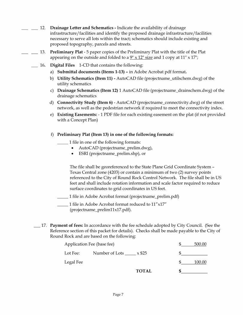
___ ___ 12. Drainage Letter and Schematics - Indicate the availability of drainage infrastructure/facilities and identify the proposed drainage infrastructure/facilities necessary to serve all lots within the tract; schematics should include existing and proposed topography, parcels and streets.
___ ___ 13. Preliminary Plat - 5 paper copies of the Preliminary Plat with the title of the Plat appearing on the outside and folded to a 9" x 12" size and 1 copy at 11" x 17";
___ 16. Digital Files 1-CD that contains the following:
a) Submittal documents (Items 1-13) – in Adobe Acrobat pdf format.
b) Utility Schematics (Item 11) - AutoCAD file (projectname_utilschem.dwg) of the utility schematics
c) Drainage Schematics (Item 12) 1 AutoCAD file (projectname_drainschem.dwg) of the drainage schematics
d) Connectivity Study (Item 6) - AutoCAD (projectname_connectivity.dwg) of the street network, as well as the pedestrian network if required to meet the connectivity index.
e) Existing Easements: - 1 PDF file for each existing easement on the plat (if not provided with a Concept Plan)
f) Preliminary Plat (Item 13) in one of the following formats:
_____ 1 file in one of the following formats:
• AutoCAD (projectname_prelim.dwg),
• ESRI (projectname_prelim.shp), or
The file shall be georeferenced to the State Plane Grid Coordinate System – Texas Central zone (4203) or contain a minimum of two (2) survey points referenced to the City of Round Rock Control Network. The file shall be in US feet and shall include rotation information and scale factor required to reduce surface coordinates to grid coordinates in US feet.
_____ 1 file in Adobe Acrobat format (projectname_prelim.pdf)
_____ 1 file in Adobe Acrobat format reduced to 11”x17” (projectname_prelim11x17.pdf).
___ 17. Payment of fees: In accordance with the fee schedule adopted by City Council. (See the Reference section of this packet for details). Checks shall be made payable to the City of Round Rock and are based on the following:
Application Fee (base fee) $ 500.00
Lot Fee: Number of Lots _____ x $25 $
Legal Fee $ 100.00
TOTAL $
Page 8
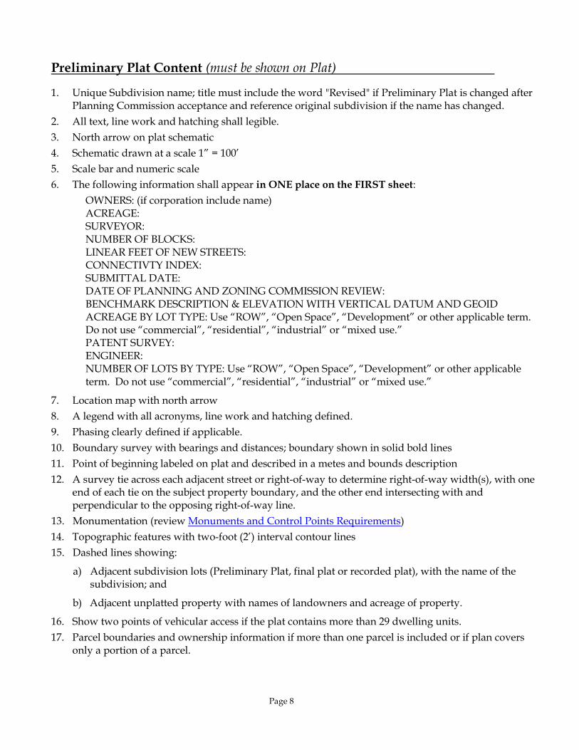
Preliminary Plat Content (must be shown on Plat)
1. Unique Subdivision name; title must include the word "Revised" if Preliminary Plat is changed after Planning Commission acceptance and reference original subdivision if the name has changed.
2. All text, line work and hatching shall legible.
3. North arrow on plat schematic
4. Schematic drawn at a scale 1” = 100’
5. Scale bar and numeric scale
6. The following information shall appear in ONE place on the FIRST sheet:
OWNERS: (if corporation include name) ACREAGE: SURVEYOR: NUMBER OF BLOCKS: LINEAR FEET OF NEW STREETS: CONNECTIVTY INDEX: SUBMITTAL DATE: DATE OF PLANNING AND ZONING COMMISSION REVIEW: BENCHMARK DESCRIPTION & ELEVATION WITH VERTICAL DATUM AND GEOID ACREAGE BY LOT TYPE: Use “ROW”, “Open Space”, “Development” or other applicable term. Do not use “commercial”, “residential”, “industrial” or “mixed use.” PATENT SURVEY: ENGINEER: NUMBER OF LOTS BY TYPE: Use “ROW”, “Open Space”, “Development” or other applicable term. Do not use “commercial”, “residential”, “industrial” or “mixed use.”
7. Location map with north arrow
8. A legend with all acronyms, line work and hatching defined.
9. Phasing clearly defined if applicable.
10. Boundary survey with bearings and distances; boundary shown in solid bold lines
11. Point of beginning labeled on plat and described in a metes and bounds description
12. A survey tie across each adjacent street or right-of-way to determine right-of-way width(s), with one end of each tie on the subject property boundary, and the other end intersecting with and perpendicular to the opposing right-of-way line.
13. Monumentation (review Monuments and Control Points Requirements)
14. Topographic features with two-foot (2’) interval contour lines
15. Dashed lines showing:
a) Adjacent subdivision lots (Preliminary Plat, final plat or recorded plat), with the name of the subdivision; and
b) Adjacent unplatted property with names of landowners and acreage of property.
16. Show two points of vehicular access if the plat contains more than 29 dwelling units.
17. Parcel boundaries and ownership information if more than one parcel is included or if plan covers only a portion of a parcel.
Page 9
18. Street layout and right-of-way must be in accordance with the City of Round Rock Master Transportation Plan., as amended.
19. Label all ROW widths; include complete curve and line data if applicable.
20. Street names must be continuous from any adjacent subdivisions.
21. Any land to be conveyed to the City of Round Rock, including, but not limited to parkland and drainage, shall require the following notation on the lot being conveyed: “To be conveyed by deed to the City of Round Rock”. In addition, the plat shall contain the following note: “A deed conveying land to the City of Round Rock, referencing the Document No. of this final plat, shall be recorded.”
22. Numbers on all proposed lots and letters on proposed blocks
23. Dimensions for front, rear, and side lot lines
24. Lot Table shown on the plat for residential subdivisions; the table shall include a labeled lot and the corresponding lot size for all lots (square feet) included in the plat
25. Designation of any special purpose lots (i.e., park, landscaping, detention, ROW, etc.); labeled and the area shown in acres.
26. If conveying parkland to the City of Round Rock, a plat note stating: “Parkland shall be conveyed to the City of Round Rock by separate document prior to the recordation of the Final Plat.”
27. Existing easements: a) All existing easements encumbering the property shall be depicted in schematic, to the extent
practical, with recording information (Cabinet & Slide, Volume & Page, or Document Number).
b) The beneficiary and type of the easement must be included in the easement label. c) Bearing and distance calls are not listed for separate instrument easements. d) Existing blanket, undefined, or unlocatable easements shall be referenced in a note on the plan.
28. Proposed easements:
a) All proposed onsite and offsite easements shall be depicted with the exception of street-side Public Utility and Sidewalk Easements abutting right-of-way (see PUE note below);
b) If dedicating an easement by plat, provide dimensions of proposed easements and label as “Proposed”. The beneficiary and type of the easement must be included in the easement label
c) If dedicating an easement by a separate instrument, identify the beneficiary of the easement leave and leave a space in the note for the document number.
29. Depiction of the ultimate 4% annual chance floodplain and the ultimate 1% annual chance floodplain with unique line types. One of the following sets of notes shall be added to the plat as applicable:
a) If the ultimate 1% annual chance floodplain does not encroach upon any portion of the tract, the following note shall be added to the plat:
“No portion of this tract is encroached by the ultimate 1% annual floodplain.”
b) If the ultimate 1% annual chance floodplain does encroach upon the tract or any adjacent tract, the following note shall be added to the plat:
“A portion of this tract is encroached by the ultimate 1% annual chance floodplain.”; AND
Page 10
“No fences, structures, storage, or fill shall be placed within the limits of the ultimate 1% annual chance floodplain; unless approved by the City Engineer. Fill may only be permitted by the City Engineer after approval of the proper analysis.”
30. For plats encroached by the ultimate 1% annual chance floodplain, and where the subject plat areais
a) Single family fee simple lots, show the minimum finished floor elevations (MFFE) for all lotsadjacent to the floodplain;
b) A condo-regime lot(s), provide an exhibit of the building layout with MFFE shown for eachbuilding pad; or
c) A non-residential lot(s), provide ultimate 1% annual chance water surface elevations atthe most upstream and most downstream locations and a note that all slab elevationsshall be a minimum of two (2) feet above the ultimate 1% annual chance floodplain.
31. Depiction of Zone A & AE FEMA floodplain with hatching or shading defined in the legend; omitdepictions of the FEMA floodway.
32. One of the following notes shall be listed on the plat, as applicable:
a) “No portion of this tract is encroached by any special flood hazard areas inundated bythe 1% annual chance flood as identified by the U.S. federal emergency managementagency boundary map (Flood Insurance Rate Map) community panel number______________, effective date _________________, for _________________ County,Texas.”
Or:
b) “A portion of this tract is encroached by special flood hazard areas inundated by the 1%annual chance flood as identified by the U.S. federal emergency management agencyboundary map (Flood Insurance Rate Map) community panel number ___________,effective date _________________, for__________ County, Texas.”
33. All drainage easements and required off-site extensions shall be labeled as “drainage and stormsewer easements”. If a drainage easement exists or is proposed, the following note shall be added tothe plat:
“No obstructions, including but not limited to fencing or storage, shall be permitted in any drainage easements shown hereon.”
34. Depiction of the Neighborhood Box Unit or Central Delivery Point Area for mail (see United States Postal Service requirements and requirements contained in Part III, Zoning and Development Code, Section 4-32, City of Round Rock, Texas, 2018, as amended).
35. Plat note stating: “Building setbacks shall be in accordance with Part III, Zoning and Development Code, Chapter 2, Zoning Districts and Use Regulations, City of Round Rock, Texas, 2018, as amended.”
36. Plat note stating: “Sidewalks shall be constructed in accordance with Part III, Zoning and Development Code, Section 6-26, City of Round Rock, Texas, 2018, as amended.”
Page 11
37. If applicable, a plat note stating: “Subdivision walls shall be located and constructed in accordance with Part III, Zoning and Development Code, Section 4-30, City of Round Rock, Texas, 2018, as amended.”
38. Plat note stating: “A ten foot (10') PUE and sidewalk easement abutting and along the street side property line is hereby conveyed for all street side property lots shown hereon.”
39. If applicable, a plat note stating: “A fifteen foot (15’) PUE and a ten foot (10’) sidewalk easement abutting and along the street side property line is hereby conveyed for all lots abutting IH35 and SH45.”
40. Plat note stating:
a) “This plat conforms to the Concept Plan approved by the Planning and Zoning Commission on [INSERT APPROVAL DATE] .”
Or:
b) “This Preliminary Plat conforms to the Concept Plan in PUD#_____ as approved by the City Council on [INSERT APPROVAL DATE].”
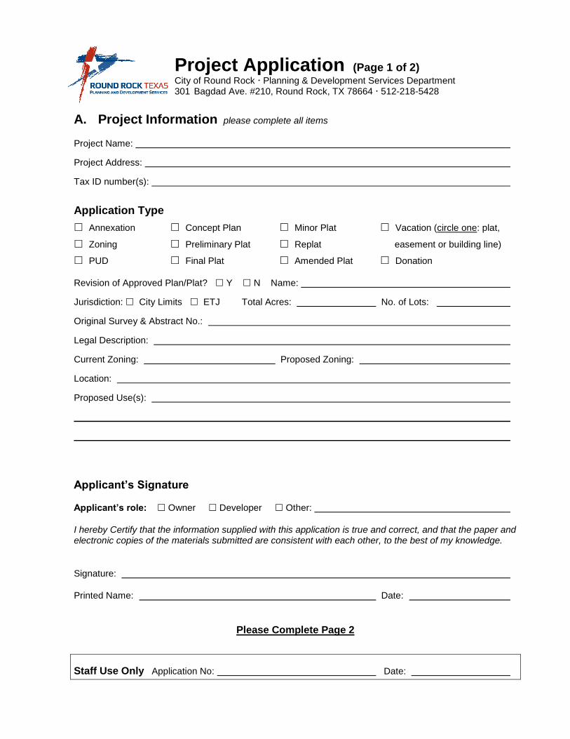
Project Application (Page 1 of 2) City of Round Rock Planning & Development Services Department 301 Bagdad Ave. #210, Round Rock, TX 78664 512-218-5428
A. Project Information please complete all items
Project Name:
Project Address:
Tax ID number(s):
Application Type
Annexation Concept Plan Minor Plat Vacation (circle one: plat,
Zoning Preliminary Plat Replat easement or building line)
PUD Final Plat Amended Plat Donation
Revision of Approved Plan/Plat? Y N Name:
Jurisdiction: City Limits ETJ Total Acres: No. of Lots:
Original Survey & Abstract No.:
Legal Description:
Current Zoning: Proposed Zoning:
Location:
Proposed Use(s):
Applicant’s Signature
Applicant’s role: Owner Developer Other:
I hereby Certify that the information supplied with this application is true and correct, and that the paper and electronic copies of the materials submitted are consistent with each other, to the best of my knowledge.
Signature:
Printed Name: Date:
Please Complete Page 2
Staff Use Only Application No: Date:
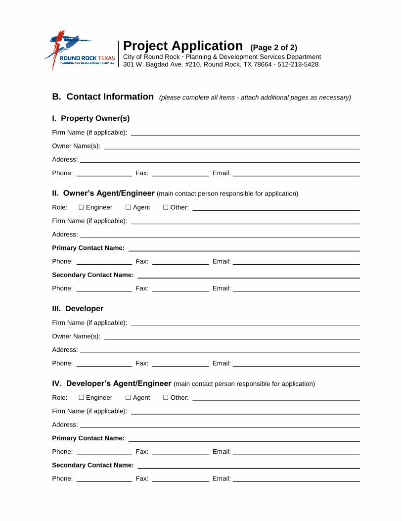
Project Application (Page 2 of 2) City of Round Rock Planning & Development Services Department 301 W. Bagdad Ave. #210, Round Rock, TX 78664 512-218-5428
B. Contact Information (please complete all items - attach additional pages as necessary)
I. Property Owner(s)
Firm Name (if applicable):
Owner Name(s):
Address:
Phone: Fax: Email:
II. Owner’s Agent/Engineer (main contact person responsible for application)
Role: Engineer Agent Other:
Firm Name (if applicable):
Address:
Primary Contact Name:
Phone: Fax: Email:
Secondary Contact Name:
Phone: Fax: Email:
III. Developer
Firm Name (if applicable):
Owner Name(s):
Address:
Phone: Fax: Email:
IV. Developer’s Agent/Engineer (main contact person responsible for application)
Role: Engineer Agent Other:
Firm Name (if applicable):
Address:
Primary Contact Name:
Phone: Fax: Email:
Secondary Contact Name:
Phone: Fax: Email:
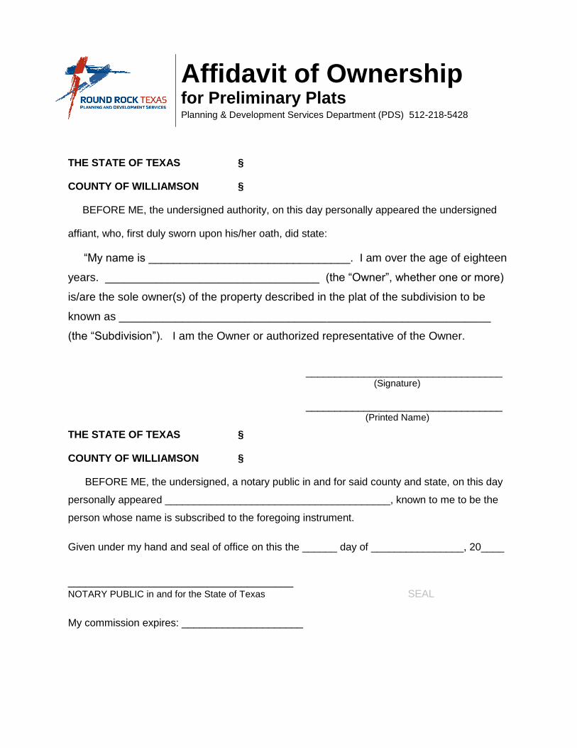
Affidavit of Ownership for Preliminary Plats Planning & Development Services Department (PDS) 512-218-5428
THE STATE OF TEXAS §
COUNTY OF WILLIAMSON §
BEFORE ME, the undersigned authority, on this day personally appeared the undersigned
affiant, who, first duly sworn upon his/her oath, did state:
“My name is ________________________________. I am over the age of eighteen
years. __________________________________ (the “Owner”, whether one or more)
is/are the sole owner(s) of the property described in the plat of the subdivision to be
known as ___________________________________________________________
(the “Subdivision”). I am the Owner or authorized representative of the Owner.
__________________________________ (Signature)
__________________________________ (Printed Name)
THE STATE OF TEXAS §
COUNTY OF WILLIAMSON §
BEFORE ME, the undersigned, a notary public in and for said county and state, on this day
personally appeared _______________________________________, known to me to be the
person whose name is subscribed to the foregoing instrument.
Given under my hand and seal of office on this the ______ day of ________________, 20____
_______________________________________ NOTARY PUBLIC in and for the State of Texas SEAL
My commission expires: _____________________

Letter of Intent for Mandatory Parkland Conveyance Parks & Recreation Department (PARD ) 512-218-5540 Planning & Development Services Department (PDS) 512-218-5428
Project name:
Submission level: Concept Plan Preliminary Plat Final Plat
Project acreage: (Proposed) Zoning:
Parkland Contribution
Parkland contribution requirements are given in the Zoning and Development Code Sections 4-61 through 4-69, available online at https://library.municode.com/tx/round_rock/codes/code_of_ordinances. For further information regarding parkland conveyance, contact Park Development Mgr. Katie Baker, 512-341-3355, [email protected].
Park Zone(s) for proposed project (refer to Park Zone map):
Number of park acres required to be conveyed:
Number of park acres proposed to be conveyed:
Proposed park improvements (list):
AND / OR
Amount required for Fee in Lieu of Parkland Conveyance: $
Property owner or authorized agent
Signature:
Printed Name: Date:
Contact Person:
Phone: Fax: Email:
Approval of Intent
Park Development Manager Date
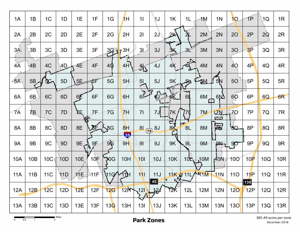
Park ZonesPark Zones
£¤79
³±130³±45
§̈¦35
1A 1B 1C 1D 1E 1F 1G 1H 1I 1J 1K 1L 1M 1N 1O 1P 1Q 1R
2A 2B 2C 2D 2E 2F 2G 2H 2I 2J 2K 2L 2M 2N 2O 2P 2Q 2R
3A 3B 3C 3D 3E 3F 3G 3H 3I 3J 3K 3L 3M 3N 3O 3P 3Q 3R
4A 4B 4C 4D 4E 4F 4G 4H 4I 4J 4K 4L 4M 4N 4O 4P 4Q 4R
5A 5B 5C 5D 5E 5F 5G 5H 5I 5J 5K 5L 5M 5N 5O 5P 5Q 5R
6A 6B 6C 6D 6E 6F 6G 6H 6I 6J 6K 6L 6M 6N 6O 6P 6Q 6R
7A 7B 7C 7D 7E 7F 7G 7H 7I 7J 7K 7L 7M 7N 7O 7P 7Q 7R
8A 8B 8C 8D 8E 8F 8G 8H 8I 8J 8K 8L 8M 8N 8O 8P 8Q 8R
9A 9B 9C 9D 9E 9F 9G 9H 9I 9J 9K 9L 9M 9N 9O 9P 9Q 9R
10A 10B 10C 10D 10E 10F 10G 10H 10I 10J 10K 10L 10M 10N 10O 10P 10Q 10R
11A 11B 11C 11D 11E 11F 11G 11H 11I 11J 11K 11L 11M 11N 11O 11P 11Q 11R
12A 12B 12C 12D 12E 12F 12G 12H 12I 12J 12K 12L 12M 12N 12O 12P 12Q 12R
13A 13B 13C 13D 13E 13F 13G 13H 13I 13J 13K 13L 13M 13N 13O 13P 13Q 13R
December 2018
385.49 acres per zone0 1 20.5Miles
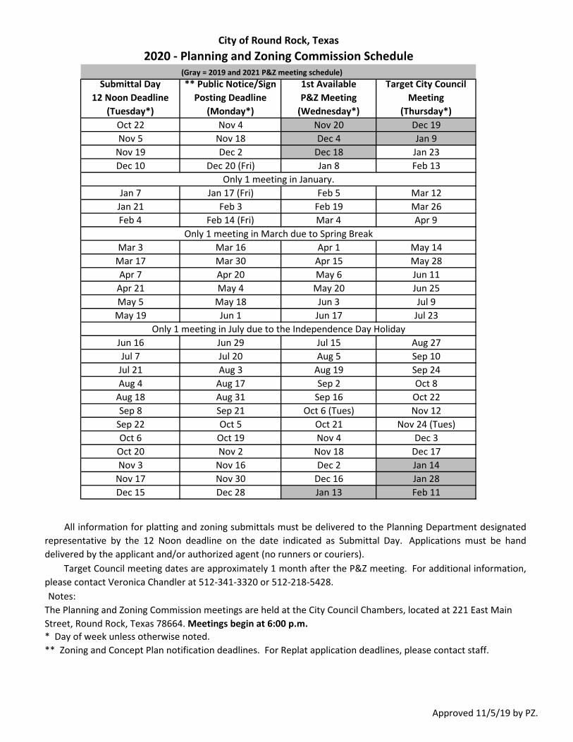
(Gray = 2019 and 2021 P&Z meeting schedule)Submittal Day
12 Noon Deadline (Tuesday*)
** Public Notice/Sign Posting Deadline
(Monday*)
1st Available P&Z Meeting
(Wednesday*)
Target City Council Meeting
(Thursday*)Oct 22 Nov 4 Nov 20 Dec 19Nov 5 Nov 18 Dec 4 Jan 9
Nov 19 Dec 2 Dec 18 Jan 23Dec 10 Dec 20 (Fri) Jan 8 Feb 13
Jan 7 Jan 17 (Fri) Feb 5 Mar 12Jan 21 Feb 3 Feb 19 Mar 26Feb 4 Feb 14 (Fri) Mar 4 Apr 9
Mar 3 Mar 16 Apr 1 May 14Mar 17 Mar 30 Apr 15 May 28Apr 7 Apr 20 May 6 Jun 11
Apr 21 May 4 May 20 Jun 25May 5 May 18 Jun 3 Jul 9
May 19 Jun 1 Jun 17 Jul 23
Jun 16 Jun 29 Jul 15 Aug 27Jul 7 Jul 20 Aug 5 Sep 10
Jul 21 Aug 3 Aug 19 Sep 24Aug 4 Aug 17 Sep 2 Oct 8
Aug 18 Aug 31 Sep 16 Oct 22Sep 8 Sep 21 Oct 6 (Tues) Nov 12
Sep 22 Oct 5 Oct 21 Nov 24 (Tues)Oct 6 Oct 19 Nov 4 Dec 3
Oct 20 Nov 2 Nov 18 Dec 17Nov 3 Nov 16 Dec 2 Jan 14
Nov 17 Nov 30 Dec 16 Jan 28Dec 15 Dec 28 Jan 13 Feb 11
Notes:
** Zoning and Concept Plan notification deadlines. For Replat application deadlines, please contact staff.
All information for platting and zoning submittals must be delivered to the Planning Department designatedrepresentative by the 12 Noon deadline on the date indicated as Submittal Day. Applications must be handdelivered by the applicant and/or authorized agent (no runners or couriers).
Target Council meeting dates are approximately 1 month after the P&Z meeting. For additional information,please contact Veronica Chandler at 512-341-3320 or 512-218-5428.
* Day of week unless otherwise noted.
City of Round Rock, Texas2020 - Planning and Zoning Commission Schedule
Only 1 meeting in January.
Only 1 meeting in July due to the Independence Day Holiday
The Planning and Zoning Commission meetings are held at the City Council Chambers, located at 221 East Main Street, Round Rock, Texas 78664. Meetings begin at 6:00 p.m.
Only 1 meeting in March due to Spring Break
Approved 11/5/19 by PZ.
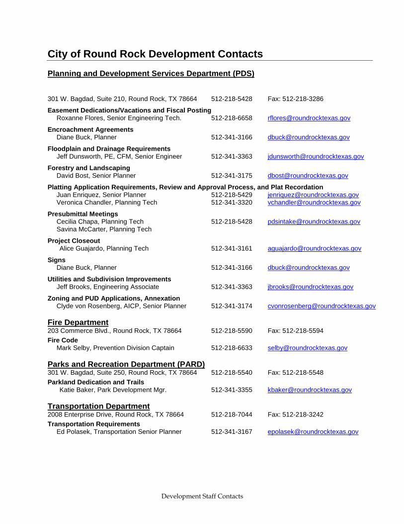
Development Staff Contacts
City of Round Rock Development Contacts
Planning and Development Services Department (PDS)
301 W. Bagdad, Suite 210, Round Rock, TX 78664 512-218-5428 Fax: 512-218-3286
Easement Dedications/Vacations and Fiscal Posting Roxanne Flores, Senior Engineering Tech. 512-218-6658 [email protected]
Encroachment Agreements Diane Buck, Planner 512-341-3166 [email protected]
Floodplain and Drainage Requirements Jeff Dunsworth, PE, CFM, Senior Engineer 512-341-3363 [email protected]
Forestry and Landscaping David Bost, Senior Planner 512-341-3175 [email protected]
Platting Application Requirements, Review and Approval Process, and Plat Recordation Juan Enriquez, Senior Planner 512-218-5429 [email protected] Veronica Chandler, Planning Tech 512-341-3320 [email protected]
Presubmittal Meetings Cecilia Chapa, Planning Tech 512-218-5428 [email protected] Savina McCarter, Planning Tech
Project Closeout Alice Guajardo, Planning Tech 512-341-3161 [email protected]
Signs Diane Buck, Planner 512-341-3166 [email protected]
Utilities and Subdivision Improvements Jeff Brooks, Engineering Associate 512-341-3363 [email protected]
Zoning and PUD Applications, Annexation Clyde von Rosenberg, AICP, Senior Planner 512-341-3174 [email protected]
Fire Department 203 Commerce Blvd., Round Rock, TX 78664 512-218-5590 Fax: 512-218-5594
Fire Code Mark Selby, Prevention Division Captain 512-218-6633 [email protected]
Parks and Recreation Department (PARD) 301 W. Bagdad, Suite 250, Round Rock, TX 78664 512-218-5540 Fax: 512-218-5548
Parkland Dedication and Trails Katie Baker, Park Development Mgr. 512-341-3355 [email protected]
Transportation Department 2008 Enterprise Drive, Round Rock, TX 78664 512-218-7044 Fax: 512-218-3242
Transportation Requirements Ed Polasek, Transportation Senior Planner 512-341-3167 [email protected]


