STRUCTURE PLAN - Department of Planning Lands Heritage
30
STRUCTURE PLAN LOT 7 CAVES ROAD QUEDJINUP October 2016 (v4)
Transcript of STRUCTURE PLAN - Department of Planning Lands Heritage

STRUCTURE PLAN
LOT 7 CAVES ROAD QUEDJINUP
October 2016 (v4)

2
This structure plan is prepared under the provisions of the City of Busselton Local Planning Scheme 21.
IT IS CERTIFIED THAT THIS STRUCTURE PLAN WAS APPROVED BY RESOLUTION OF THE WESTERN AUSTRALIAN PLANNING COMMISSION ON:
Signed for and on behalf of the Western Australian Planning Commission:
_____________________________________________________________
an officer of the Commission duly authorised by the Commission pursuant to section 16 of the Planning and Development Act 2005 for that purpose, in the presence of:
_______________________________________________________________ Witness
_______________________________________________________________ Date
_______________________________ Date of Expiry

3
Table of amendments
Amendment No.
Summary of the Amendment
Amendment type Date approved by WAPC

4
Executive summary This Structure Plan relates to the whole of Lot 7 Caves Road Quedjinup.
The Structure Plan facilitates the subdivision and development of the land into 7 rural residential lots in keeping with the zoning of the land.
Subdivision of the land will be undertaken in stages with the first stage to include the creation of three rural residential lots and a balance of title lot.
Studies undertaken to support the proposal confirm that the land is suitable for subdivision and future development by way that it has an acceptable Bushfire Attack Level (BAL), capacity to deal with effluent disposal and drainage on site. Subdivision and development can occur on the site without impacting upon the existing natural environment and in fact, will contribute to habitat restoration through implementation of landscaping along the Caves Road frontage as required.
The Structure Plan compliments and is consistent with the Commonage Consolidated Structure Plan.

5
Contents
Endorsement page 2
Table of amendments 3
Executive summary 4
Table of contents 5
Part One: Implementation 6
Part Two: Explanatory section 13
Technical appendices 30

6
PART ONE –IMPLEMENTATION

7
1 Structure Plan Area
This Structure Plan applies to Lot 7 Caves Road, Quedjinup, consisting of all land contained within the inner edge of the line denoting the Structure Plan Boundary on the Structure Plan Map.
The Structure Plan Area is bounded by Caves Road to the west and Quedjinup Drive to the South.
The Structure Plan Area comprises an individual lot, as outlined in the table below:
Table 1: Site Details.
Lot Number Plan Number Street Address Area
7
64637 Lot 7 Caves Road, Quedjinup
17.0907 hectares

8
2 Operation
In accordance with the Deemed Provisions of the Scheme, this Structure Plan shall come into operation when it is has been approved by the Western Australian Planning Commission (WAPC) pursuant to clause 22 (1)(a)

9
3 Staging
The intended staging of the proposed subdivision is depicted on the Structure Plan. Lots 1-3 are to be constructed in stage 1 and the remainder of lots to be constructed in a subsequent stage. There is insufficient nexus between Stage 1 and the need for the extension of Quedjinup Drive to Caves Road. As such, Quedijinup Drive is not to be constructed in Stage 1, however a suitable mechanism is to be demonstrated within the Stage 1 subdivision application securing the construction of the road within a suitable timeframe to the satisfaction of the Local Government.

10
4. Subdivision and Development Requirements
General
1 This Structure Plan provides a framework for the future subdivision and development of the land. Deviation from the Structure Plan beyond a minor adjustment, may require a Structure Plan amendment to be lodged prior to subdivision.
2. This Structure Plan is to be read in conjunction with the Bushfire Management Plan and Environmental Assessment.
Subdivision Requirements
At the time of subdivision, the subdivider shall:
3. Implement buffer planting as required by the Environmental Assessment dated August 2014.
4. Include a notification on the Certificates of Title advising prospective purchasers of the requirement to comply with the approved Bushfire Management Plan and their responsibility to maintain fire protection measures and emergency access to an appropriate standard.
5. Implement a Bushfire Management Plan which has been approved by the City of Busselton and Department of Fire and Emergency Services.
6. Locate crossover points fronting Quedjinup Drive to the satisfaction of the City of Busselton. Such crossovers as to be inclusive of measures to retain the functionality of the existing drainage swale.
7. Set aside the land shown on the Structure Plan as being necessary for the widening of Caves Road, as a separate lot pending acquisition by Main Roads.
8. Provide the road reserve for the extension of Quedjinup Drive.
9.Provide an easement over the existing crossover servicing Lot 7 from Caves Road for the purpose of providing vehicular access to Lot 7 pending construction of the future road widening.
10.Submit details of effluent disposal with a site-specific geotechnical assessment to a depth of 2 metres, to confirm the suitability of all development sites for on-site effluent disposal systems.
11. Include a notification on the Certificate of Titles advising prospective purchasers of the risk of mosquito-borne disease and the potential for nuisance mosquitoes.

11
12. At the time of subdivision of Stage 1, Quedjinup Drive is not required to be constructed, but the application must demonstrate a suitable mechanism to secure the construction of Quedjinup Drive within a suitable timeframe to the satisfaction of the Local Government.
Development Requirements
13. Provision of alternative treatment units may be required in some locations where sufficient depth to groundwater cannot be achieved or soil conditions are not ameliorable.
14. Dwellings on Lots 5 and 6 are to be located no closer than 27m from vegetation shown on the Structure Plan as being an extreme fire hazard in order to achieve BAL ratings of no greater than BAL29.
15.No development or clearing shall occur within the Building Exclusion Area.
16. Direct access from Lots 5 and 6 to Caves Road is not permitted.

12
PLAN 1

LOT 5
LOT 4LOT 6
LOT 7
2.63 ha
1.80 ha 1.20 ha
6.92 ha
QUEDJINUP DRIVE
10 m wide roadwidening
vegetation buffer
STRUCTURE PLANLot 7 Caves Rd, Quedjinup
ELTONDESIGN
Drawn by: S Elton Client Name:
Created by: ELTON DESIGN -16/37 Village Green 6285 - Contact : Susan Elton 044 778 0418
MOOOD Pty Ltd
Lot 7 Caves Road - Quedjinup Oct 2016Date: Scale:1:2000
CAVE
S RO
AD
100m setbackto Caves Road
intersection designto Main Roads WAspecifications
(existing) dam
extreme fire hazard
road widening
(building exclusion area)
(building exclusion area)
LOT 21.03 ha
LOT 31.07 ha
LOT 11.03 ha
Reciprocal rightsof access
Subdivision - Stage 2
Subdivision - Stage 1
Vegetation buffer
Building exclusion area
Road widening
Extreme bushfire hazard

13
Part Two - Explanatory Section

14
1 PLANNING BACKGROUND
1.1 Introduction and purpose The subject land has the capacity for further subdivision into rural residential lots by virtue of its zoning and its inclusion within the Commonage Consolidated Structure Plan. In accordance with the applicable planning requirements, this Structure Plan will set out a framework for the future subdivision of the land in to 7 lots. 1.2 Land description 1.2.1 Location The subject land is lot 7, location 1949 Caves Road. It is located in the locality of Quedjinup just 5km from the nearby townsite of Dunsborough. The property is known as ‘Summer Paddock’. Surrounding land on the eastern side of Caves Road has previously been subdivided into rural residential lots ranging in size from 1 to 2 ha.
Figure 1 – Proximity of subject land to Dunsborough townsite. 1.2.2 Area and land use The land is 17.09ha in size and is currently used for a range of rural purposes, most particularly, the agistment of horses (see Appendix 1).

15
Figure 2 – Aerial photograph showing subject land and surrounds. 1.2.3 Legal description and ownership The subject land is owned in fee simple. This application is made on behalf of MOOOD Pty. Ltd. (see Appendix 2). 1.3 Planning framework 1.3.1 Zoning and reservations The subject land is zoned ‘Rural Residential’. Policies of the zone as set out by LPS21 relevant to this proposal are as follows: (a) To encourage rural residential subdivision by permitting a range of lot sizes in conventional subdivision subject to a general minimum lot area of 1 hectare with an average minimum lot area of approximately 2 hectares; and providing greater flexibility for lots created within appropriate cluster subdivisions or by strata or survey strata subdivision, dependent upon the special physical characteristics of the land. (e) To encourage generally, and require specifically in rural residential subdivision, the provision of vegetation and fauna corridors and the revegetation of the land. (f) To adequately protect any areas or sites of conservation value within the design of any subdivision and development.

16
1.3.2 Structure plans The preparation of a Structure Plan for the subject land is guided by the Commonage Consolidated Structure Plan, which relates to the broader Commonage rural residential area. As is evident by reviewing Figure 3, key issues relating to the subject land are: • A setback for development of 100m from Caves Road; • The need for vegetative screening along caves Road; and • The potential for a connection between Quedjinup Drive and Caves Road
Figure 3 – Except from Commonage Consolidated Structure Plan (property identification added)
Applicable text contained within the accompanying document is set out as follows:

17
1.3.3 Planning Strategies The City of Busselton Rural Strategy is relevant to the subject proposal by virtue of its reference at Policy (h) of the Rural Residential zone which states:
To generally implement and adhere to the adopted recommendations and outcomes of the City of Busselton Rural Strategy as endorsed by the WA Planning Commission; The subject land falls within Precinct 6 ‘Commonage’ (see figure 4). Subdivision criteria set out at section 7.6.8 of the Rural Strategy, and relevant to this proposal are:
– Rural residential subdivision is limited to existing 'Rural Residential' zones and is to be in accordance with adopted Structure and Development Guide Plans (including the Commonage Policy Area Consolidated Structure Plan).
– In accordance with the LNRSPP.
Figure 4 – Except from City of Busselton Rural Planning Strategy (property identification added)

18
1.3.4 State Planning Policies The subject land falls within the area guided by State Planning Policy 6.1 – Leeuwin Naturaliste Ridge Statement of Planning Policy (LNRSPP). It is identified as being suitable for ‘Rural Residential use (see Figure 5). Relevant policies relating to the rural residential zone are: LUS 1.2 Rural Residential will be restricted to the areas shown in the Land Use Strategy Plan.
LUS 1.25 Subdivision and development design that facilitates better use of land already committed for Rural Residential development will be encouraged. Assessment of proposals will address the following criteria—
– provision for clustered settlement; – provision of community-based activities and services; – provision for walking, cycling and possible future public transport; – opportunities for local enterprise development such as limited small-scale tourism development, including accommodation, attractions and cottage industries; and – suitability for small-scale intensive agriculture.
The subject land is also identified by the LNRSPP as being within a ‘Travel Route Corridor’ with ‘General Character’ owing to its location on Caves Road. Relevant polices are therefore:
PS 3.4 In areas of Natural Landscape Significance, including where they are in Travel Route Corridors, the significant natural characteristics will be protected and provide adequate development setbacks. In these areas development will be screened from Travel Route Corridors except public recreation or safety facilities which may be seen in the foreground. PS 3.7 In areas of General Character, as identified in Figure 3, development or change of use should protect the rural character and conform with policies and guidelines for Travel Route Corridors.
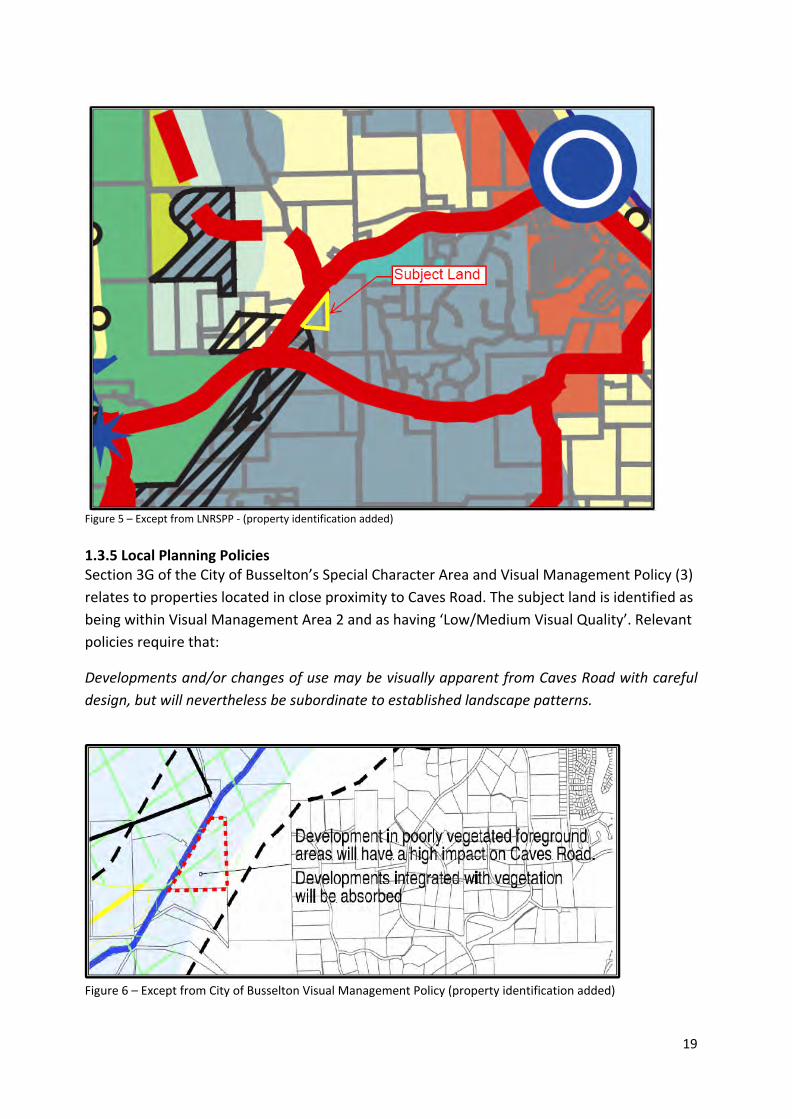
19
Figure 5 – Except from LNRSPP - (property identification added) 1.3.5 Local Planning Policies Section 3G of the City of Busselton’s Special Character Area and Visual Management Policy (3) relates to properties located in close proximity to Caves Road. The subject land is identified as being within Visual Management Area 2 and as having ‘Low/Medium Visual Quality’. Relevant policies require that:
Developments and/or changes of use may be visually apparent from Caves Road with careful design, but will nevertheless be subordinate to established landscape patterns.
Figure 6 – Except from City of Busselton Visual Management Policy (property identification added)

20
1.3.5 Other approvals and decisions The subject land adjoins a similarly zoned property which is subject to ‘Development Guide Plan 226 (Revision 2) Lots 30-35 Caves Road Yallingup’ (see Appendix 3). This plan is relevant to the size, number and arrangement of lots on the subject land, which have been designed to be consistent with DGP 226.

21
2 Site Conditions and Constraints
2.1 Biodiversity and natural area assets According to the flora survey conducted by Sean Smith (see Appendix 4) the vegetation type that would have occurred over the site is classified as NVIS Vegetation Type 897, medium forest of jarrah and marri (Department of Agriculture, 2014).The land however was cleared many years ago for farming purposes. The vegetation now present on the site consists primarily of planted exotic wind-breaks along the fence lines of the existing paddocks. Typical species include tuart (Eucalyptus gomphocephala), blue gum (Eucalyptus globulis), Rose gum (Eucalyptus grandis), swamp mahogany (Eucalyptus robusta), Sydney Golden Wattle (Acacia longifolia), Callistemon species, Pincushion hakea (Hakea laurina), conifers and several other non-local eucalypt species. The South West corner of the site is exceptional in that it contains some native species. No declared rare or priority species have been identified on the site. 2.2 Landform and soils The site is generally flat with only a gradual slope across its extent of 2% (see Figure 7).
Figure 7 – Site contours.

22
The soils over the majority of the overall site are characterized as the Cowaramup wet vales phase (COvw). The soils on the south-western portion of the site are characterized as the Cowaramup deep sandy rises phase (COd2) (Department of Agriculture, 2014).
Figure 8 – soil classifications. An assessment of the soils nearby to building envelopes shown on the DGP has been undertaken to determine their suitability for development and on site effluent disposal. The full details of the geotechnical studies carried out can be found at Appendix 4 however in summary all sites achieve a class I or II rating against the Wells index (2001) and thus are suitable for use of conventional septic tank and leach drain effluent disposal systems – see Figure 9. Notwithstanding these findings the City of Busselton have requested the use of secondary treatment systems on lots which contain the Cowaramup wet vale soil type being lots 4, 5 and 6. The DGP carries a planning provision which ensures that this will be the case.

23
Figure 9 – Location of soil samples Soils from a number of test pits were analysed for their PRI value, which ranged widely across the site. It is recommended that a suitable soil amendment is added to the disposal fields to increase the phosphorous binding capacity of the soils (to increase the PRI above 20), where the soil PRI is lower (soils on lots matching pits 3, 4, 5, 6 and 7). The DGP carries a planning provision which ensures that this will be the case. 1.3 Groundwater and surface water The south of the site is the Yallingup Brook. As discussed at section 2.2, the depth to ground water across the site is approximately 2m. The depth of groundwater results in the site being conducive to the use of septic tank type effluent disposal systems without adverse risk to the environment. The distance between the nearest building envelopes to Yallingup Brook at 200m, means that development will be well outside of the Department of Water (2010) recommended buffer distance of 100 metres from sensitive water resources for conventional wastewater systems for soils with a PRI up to 5.

24
1.4 Bushfire hazard A bushfire hazard assessment and management plan have been prepared for the site (see Appendix 5). An assessment of the vegetation on site finds that there is a low to moderate threat level, which can be managed through a variety of measures in accordance with State and Local guidelines. Key fire protection mechanisms required by the BMP are: • Construction of dwellings to the required standard as set out by AS3959, and as relates
to the BAL rating for each lot (see figure 10) • A minimum 27m setback of dwellings from defined bushfire hazard areas.
• (i) All future dwellings shall be sited to ensure a maximum BAL-29 rating; • (ii) Future dwellings to be constructed in accordance with AS3959; • (iv) Existing private driveways shall be upgraded to meet A3.5 standards; • (v) The proposed development complies with all Performance Principles detailed in
draft SPP3.7 Planning for Bushfire Risk Management through the use of Acceptable Solution and Performance Based design solutions; and
• (vi) The subject lots shall have a s70A Notice on Title identifying this Bushfire Management Plan is to be complied with.
It is noted that an emergency escape route/pedestrian accessway is provided on the adjoining property to the south and secured by an easement. From a bushfire safety perspective there is no demonstrated need to provide a public road link to Caves road at this location, nor is such a link supported by Main Roads WA. The Shire and WAPC however, have advised that a road link should be provided and this is accommodated in the proposal.
Figure 10 – BAL Ratings Notwithstanding the BAL rating’s set out above, and in accordance with the City of Busselton’s Planning Policy 9b ‘Bush Fire Protection Local Planning Policy Provisions’, “the minimum construction standard in all cases, other than for minor building work, is BAL 19.”

25
Figure 11 – Bushfire hazard assessment 1.5 Heritage A search of the Department for Indigenous Affairs database confirms that there are no known aboriginal heritage sites within or in close proximity to the subject land (see Appendix 6).

26
3.0 Land Use and Subdivision Requirements
3.1 Land use The proposed land use is ‘Rural Residential’ which is consistent with the existing zoning of the land and the use of surrounding land which is similarly zoned. 3.2 Open space No public open space contribution is required by WAPC or Shire policy given the large size of the proposed lots. 3.3 Rural Residential Lot Yield The Commonage Consolidated Structure Plan makes various conflicting statements with respect to the number of lots which the site should be subdivided into which are summarised as follows: • General requirement - Min 2ha average 3ha – provides for 5.6969lots • Note (specific to lots 5 and 7) – 20% increase to the 3ha average – provides for
6.8362lots The Proposed Structure Plan outlines how the subject land could be divided into 7 lots consistent with the notes relating specifically to the subject land on the CCSP. This is the City of Busselton’s preferred approach. It is noted that at this density (average of 1 lot per 2.4 ha), subdivision would achieve a consistent density to that approved for the lot which adjoins its southern boundary, which, from an area of 14.55ha, can achieve a lot yield of 6 at an average density of 1 lot per 2.4ha. The proposed density allows for the key planning objectives for the land to be realised, being: • Development will be clustered in the southern half of the site • Development will be at least 100m from Caves Road and screened by existing and
proposed vegetation buffer planting (with the exception of Lot • The density is consistent with the character and density of surrounding development • The size and arrangement of lots allows the more heavily vegetated portion of the lot
to remain in one larger (6ha) lot.
In respect to the CCSP requirements relating to community benefit, it is recommended that the community benefits offered by this subdivision are primarily related to the completion of the strategic link between Quedjinup Drive and Caves Road. This intersection has been planned for some time by way of its depiction on the CCSP. Currently residents in the area need to ‘back track’ away from Caves Road via Quedjinup Drive to Biddle Road in order to access Caves Road which is obviously the main link to Dunsborough/Yallingup and beyond. This subdivision will be the catalyst for delivery of an intersection which will allow a more direct route to employment, goods and services significantly reducing travel time and traffic on minor roads.

27
The Quedjinup Road link will not only provide for resident traffic but will also provide an important access point for emergency vehicles (including fire-fighting units) saving time which could be critical in an emergency. This does not simply benefit the proposed lots but the locality more broadly. The proposal will also require that a contribution is made towards community facilities which will have a corresponding community benefit. It should be noted that the community benefit resulting form completion of the road network will not be realised in the foreseeable future unless the subdivision is of sufficient scale as to make construction of the connection viable or the City commits sufficient funding to assist with the intersection construction. 3.4 Movement networks The subject land has frontage to both Caves Road and Quedjinup Drive. The existing dwelling takes its access from Caves Road, however given the status of that road as a ‘Restricted Access Road’, additional connections and crossovers are undesirable. The Commonage Consolidated Structure Plan identifies an indicative subdivisional road layout over the site which extends Quedjinup Drive such that it intersects with Caves Road. Correspondence with Main Roads however has confirmed that such a connection would not be approved by that agency (see Appendix 7). Subsequent to this, the City of Busselton undertook consultation with the Department of Planning, and provided advice that those agencies would require a road connection with Caves Road (see Appendix 8). A road reserve linking the existing Quedjinup Drive with Caves Road is shown on the structure Plan. The WAPC has determined that the first stage of subdivision which will create three lots (as shown on the Structure Plan) will not necessitate any extension of Quedjinup Drive, as these lot will take access from the existing road. As required by Main Roads a 10m wide strip of land has been identified as requiring transfer to Main Roads. As such, it will be set aside as a separate lot upon subdivision, so that it can be subsequently purchased by Main Roads for the purposes of future works in Caves Road. 3.5 Water management In accordance with the WAPC’s Better Urban Water Management (2008) an Urban Water Management Plan is not required for the site given the number and size of the lots proposed. Storm water will be collected from rooftops in 135,000 litre water tanks. Excess stormwater will be discharged on site and given the permeability of the soil on site this is acceptable. 3.6 Education facilities N/a 3.7 Activity centres and employment The subject site is located in close proximity to the Town of Dunsborough.

28
3.8 Developer contribution arrangements Upon the creation of each lot, a contribution towards community infrastructure will be made to the Shire in accordance with Schedule 15 DCA1 for the ‘Other Rural’ precinct.
It is understood that the Shire currently holds funds previously achieved through the Commonage Contribution policy requirement. It is requested that these funds be utilised to assist with the construction of a road intersection at the junction of Quedjinup Drive and Caves Road. This is on the basis that this intersection provides a broad benefit which extends well outside of the subject land and therefore it should not be the subdividers sole responsibility for funding its construction.
3.9 Visual Management In accordance with Council Policy No. 3, the LNRSPP and CCSP, there is a need for screening along Caves Road to ensure future residential development on the site is inevident in the landscape.
Figure 12 – View of property from Caves Road
In response to the applicable planning policies, a landscape assessment was undertaken of the site, to determine the most appropriate ways of screening development (see Appendix 4). In addition to a 100m development setback and existing roadside vegetation both within the property and on the road reserve, additional planting is recommended (see Figure 13). The DGP carries a requirement that buffer landscaping be implemented as part of the subdivisional works.

29
Figure 13 – Visual management buffer planting.