Strong Base-Metal Sulphide Zone above Large EM Conductor ...
14
Australian Gold and Copper Ltd ACN 633 936 526 1 3 May 2021 Strong Base-Metal Sulphide Zone above Large EM Conductor at Achilles Maiden RC Drilling at the Cargelligo Project’s Achilles target highlights significant base-metal sulphides above large EM conductor The highlight was hole AC3RC004 which intercepted: 5m @ 4.9% Pb + Zn, 0.3% Cu, 5g/t Ag from 89m including 1m at 10.7% Pb + Zn, 1.4% Cu, 12g/t Ag from 89m within 46m at 1.0% Pb + Zn, 0.1% Cu and 2g/t Ag from 73m Mineralisation is open to the east and down dip towards untested EM conductor 500m wide target zone identified along 8km long Achilles shear zone Pathfinder elements upgrade potential of EM conductor RC Drill rig contracted for follow up drilling at Cargelligo’s Achilles target and 8km trend, and the Moorefield Projects Au-Cu targets Australian Gold and Copper Ltd (ASX: AGC) (“AGC” or the “Company”) is pleased to report the assay results from the Company’s first 7-hole RC drilling program (1,242m) at the 100% owned Cargelligo Project, Achilles target. Figure 1: Achilles west to east cross section through 6330500N showing Pb+Zn>0.2% significant assays downhole above EM conductor. Intensely altered volcanic rocks were drilled in the 500m wide target zone.
Transcript of Strong Base-Metal Sulphide Zone above Large EM Conductor ...

Australian Gold and Copper Ltd
ACN 633 936 526
1
3 May 2021
Strong Base-Metal Sulphide Zone above Large EM Conductor at Achilles
Maiden RC Drilling at the Cargelligo Project’s Achilles target highlights significant base-metal sulphides above large EM conductor
The highlight was hole AC3RC004 which intercepted: 5m @ 4.9% Pb + Zn, 0.3% Cu, 5g/t Ag from 89m including 1m at 10.7% Pb + Zn, 1.4% Cu, 12g/t Ag from 89m
within 46m at 1.0% Pb + Zn, 0.1% Cu and 2g/t Ag from 73m
Mineralisation is open to the east and down dip towards untested EM conductor
500m wide target zone identified along 8km long Achilles shear zone
Pathfinder elements upgrade potential of EM conductor
RC Drill rig contracted for follow up drilling at Cargelligo’s Achilles target and 8km trend, and the Moorefield Projects Au-Cu targets
Australian Gold and Copper Ltd (ASX: AGC) (“AGC” or the “Company”) is pleased to report
the assay results from the Company’s first 7-hole RC drilling program (1,242m) at the
100% owned Cargelligo Project, Achilles target.
Figure 1: Achilles west to east cross section through 6330500N showing Pb+Zn>0.2% significant assays
downhole above EM conductor. Intensely altered volcanic rocks were drilled in the 500m wide target zone.

2
Figure 2: Achilles target plan map showing drill collars and traces drilling underneath a lead in soil anomaly
(previously reported ASX AGC Prospectus) which continues south along the hills and fades underneath the
transported cover to the east. The figure 1 cross section line marked location. The east to west areal EM
flight line is in blue and locations of the deeper EM anomalies are marked by red hashed ovals.
3
Intersecting banded base-metal sulphides reinforce the prospectivity of Achilles and more
importantly that the 8km long Achilles shear zone has the potential to host significant
mineralisation. The potential at Achilles is further encouraged by the significant EM
conductor below, see figure 1 and 2.
Significant intercepts include:
Hole A3RC004:
5m @ 4.9% Pb + Zn, 0.3% Cu and 5g/t Ag from 89m
Including 1m at 10.7% Pb + Zn, 1.4% Cu and 12g/t Ag from 89m
Within 46m at 1.0% Pb + Z, 0.1% Cu and 2g/t Ag from 73m
Hole A3RC005
5m at 1.0% Pb + Zn and 4g/t Ag from 112m
Within 32m at 0.3% Pb + Zn and 5g/t Ag from 87m
Mineralisation in hole A3RC004 intercepted banded and disseminated base-metal
sulphide mineralisation including galena, sphalerite and chalcopyrite (figure 3 below).
Figure 3: RC chips from hole A3RC004 mineralised interval 89-91m. The grey mineral is galena (lead
sulphide), red-brown mineral is sphalerite (zinc sulphide).
This is a significant interval of mineralisation for a maiden drill program in the Southern
Cobar Basin. To place it in context, intervals of similar widths and grades were drilled in
two holes above the Hera deposit in 1984 (Cooper, 2017) and this Hera discovery led to
the first mine operated by Aurelia Metals (ASX:AMI). Similar to Achilles, the Hera mine is
also located on the eastern margin of the Cobar Basin, 120km north (figure 6), see AGC
ASX prospectus for further details.
Five of seven drill holes (A3RC003-A3RC007) intercepted encouraging alteration zones
with strong quartz, sericite, chlorite, pyrite alteration of felsic volcaniclastics and silicified
siltstones/sandstones dipping to the east, with disseminated galena (lead sulphide). This
zone lies directly above the EM conductor and hence provides significant encouragement
for further drilling.

4
Figure 4: AC3 cross sections showing various anomalous base-metals and their downhole positions.
Figure 5: AC3 cross sections showing various anomalous pathfinder elements and their downhole positions.
The bismuth anomaly is increasing towards the south and strongest in the two southern most holes
A3RC004 and A3RC007, supporting evidence that the anomaly is open to the south towards the deeper EM
conductor.
Concealed Geology to the East
Transported sand and cover conceals the geology and soil anomalies immediately east of
Achilles hills. Drill hole A3RC005, drilled 500m to the east, and was an important hole as
it demonstrated the prospective zone is not only confined to the hills but also open to the
east and concealed under shallow cover. This knowledge allows AGC to plan further
programs knowing the mineralised corridor is over 500m wide and partly concealed.

5
Follow Up Drilling and Exploration
A soil sampling program is already underway along the Achilles corridor with the aim to test
for extensions to the Achilles soil anomaly along the 8km trend to the South.
A rig has been contracted for a RC drill program testing underneath and down dip from
A3RC004. In AGC’s view, there is strong potential for further mineralisation down plunge
towards the EM anomaly, also along strike and to the east under shallow cover.
This RC program is planned to start towards the end of May before it goes to our Moorefield
Au-Cu Project.
More regionally, an aircore program is being permitted to test the 8km Achilles trend where
the soil sampling is ineffective due to being concealed by transported sand and cover. This
aircore program is planned to start towards the end of June.
Table 1: Achilles RC drill collar details for AC3RC001-AC3RC007 (GDA94)
Table 2: Achilles significant Intersections (down hole widths, true widths not calculated)
*Internal dilution calculated by total number of meters <1000ppm Pb+Zn in the quoted interval, intervals
were cut by having no more than 2m<1000ppm Pb+Zn consecutively.
Hole ID TypeEnd of
Hole (m)East North RL Dip Az
A3RC001 RC 186 424676 6330070 163 -60 270o
A3RC002 RC 132 424745 6330236 169 -60 270o
A3RC003 RC 198 425140 6330556 166 -60 270o
A3RC004 RC 200 425166 6330411 171 -60 270o
A3RC005 RC 210 425509 6330522 156 -60 270o
A3RC006 RC 178 425246 6330496 156 -60 270o
A3RC007 RC 138 425197 6330336 159 -60 270o
Hole ID From (m) To (m) Interval (m)Internal
Dilution*Cu (%) Pb (%) Zn (%) Zn+Pb (%) Au (g/t) Ag (g/t) Comments
A3RC003 13 14 1 0.13 oxide
and 43 83 40 3 0.0 0.1 0.1 0.2 1Wide zone of
anomalous Pb Zn
and 131 140 9 1 0.0 0.1 0.2 0.2 0
A3RC004 59 67 8 0.1 0.0 0.1 0.1 2 Bi to 89ppm
and 73 119 46 3 0.1 0.2 0.8 1.0 2Wide zone of
anomalous Pb Zn
incl 89 94 5 0 0.4 1.3 3.6 4.9 5 Pb Zn Cu zone
incl 89 90 1 0 1.4 3.0 7.6 10.6 12Best 1m interval,
inc 31ppm Mo
and 110 111 1 0.0 0.5 1.0 1.5 4
and 130 138 8 0 0.0 0.1 0.2 0.2 0
and 176 181 5 0.0 0.0 0.2 0.2 0
A3RC005 69 75 6 0 0.0 0.0 0.1 0.1 2
and 87 119 32 3 0.0 0.2 0.2 0.3 5Wide Zone of
anomalous Pb Zn
incl 112 117 5 0 0.0 0.4 0.6 1.0 4
A3RC006 124 126 2 0 0.0 0.2 0.4 0.6 1.0
A3RC007 92 100 8 1 0.2 0.0 0.1 0.1 0.0
Mo average
31ppm, Bi average
11ppm

6
Pattons RC Drill Results
All assays have now been received for Pattons RC drilling and despite strong gold
anomalism in rock float on surface and similar rocks including strong alteration being
intercepted over 550m of strike length in 6 holes, no significant gold anomalism was
returned in the assays. Best results were 1m at 0.8g/t Au from 81m in PTRC001 and 4m
at 0.2g/t from 189m in hole PTRC007
References
AGC ASX prospectus lodged 18th November 2020
Cooper I., 2017, Finding Hera, Looking for the rest of the family, CWEDG.
http/s://www.smedg.org.au/pdf/CWEDGAug2017FindingHera.pdf

7
AGC Projects Overview
AGC’s portfolio located in the Central Lachlan Fold Belt includes the Moorefield gold
project, located in similar aged rocks to the Fosterville Gold mine (one of the world’s most
profitable underground gold mines), the Cargelligo base-metal project in the southern
Cobar Super-Basin exploring for Hera and Federation style deposits, and the Gundagai
project, exploring for multi-million ounce McPhillamy’s type gold deposits.
Figure 6. Location of the Cargelligo, Moorefield and Gundagai Projects in relation to major
mines and deposits within the Lachlan Fold Belt., see p100 AGC ASX prospectus lodged 18th
November 2020.

8
This announcement has been approved for release by the Board of AGC.
ENDS
For further information:
Glen Diemar
Managing Director
Australian Gold and Copper Limited
+61 434 827 965
www.austgoldcopper.com.au
For media enquiries:
Jane Morgan
Director
Jane Morgan Management
+61 405 555 618
Forward-Looking Statements
This announcement contains “forward-looking statements.” All statements other than those of historical
facts included in this announcement are forward-looking statements. Where the Company expresses or
implies an expectation or belief as to future events or results, such expectation or belief is expressed in good
faith and based upon information currently available to the company and believed to have a reasonable
basis. Although the company believes the expectations expressed in such forward-looking statements are
based on reasonable assumptions, such statements are not guarantees of future performance and no
assurance can be given that these expectations will prove to be correct as actual results or developments
may differ materially from those projected in the forward-looking statements. Forward-looking statements
are subject to risks, uncertainties and other factors, which could cause actual results to differ materially from
future results expressed, projected or implied by such forward-looking statements. Such risks include, but
are not limited to, copper, gold, and other metals price volatility, currency fluctuations, increased production
costs and variances in ore grade or recovery rates from those assumed in mining plans, as well as political
and operational risks and governmental regulation and judicial outcomes. Readers are cautioned not to
place undue reliance on forward-looking statements due to the inherent uncertainty thereof. The forward-
looking statements contain in this press release are made as of the date of this press release and except as
may otherwise be required pursuant to applicable laws, the Company does not undertake any obligation to
release publicly any revisions to any “forward-looking statement”.
Competent Persons Statement
The information in this document that relates to Exploration Results, Mineral Resources or Ore Reserves is
based on information compiled by Mr Glen Diemar who is a member of the Australian Institute of
Geoscientists. Mr Diemar is a full-time employee of Australian Gold and Copper Limited, and is a shareholder,
however Mr Diemar believes this shareholding does not create a conflict of interest, and Mr Diemar has
sufficient experience which is relevant to the style of mineralisation and type of deposit under consideration
and to the activity which he is undertaking to qualify as a Competent Person as defined in the 2012 Edition
of the “Australasian Code for Reporting of Exploration Results, Mineral Resources and Ore Reserves”. Mr
Diemar consents to the inclusion in this presentation of the matters based on his information in the form
and context in which it appears.
Previously Reported Information
The information in this report that references previously reported exploration results is extracted from the
Company’s ASX IPO Prospectus released on the date noted in the body of the text where that reference
appears. The ASX IPO Prospectus is available to view on the Company's website or on the ASX website
(www.asx.com.au). The Company confirms that it is not aware of any new information or data that materially
affects the information included in the original market announcements. The Company confirms that the
form and context in which the Competent Person’s findings are presented have not been materially modified
from the original market announcements.

9
Appendix I – JORC Code, 2012 Edition – Table 1
Section 1 Sampling Techniques and Data: Cargelligo Project, Achilles RC Drilling Criteria JORC Code explanation Commentary
Sampling techniques
Nature and quality of sampling (eg cut channels, random chips, or specific specialised industry standard measurement tools appropriate to the minerals under investigation, such as down hole gamma sondes, or handheld XRF instruments, etc). These examples should not be taken as limiting the broad meaning of sampling.
RC drilling and sampling was undertaken by Durock Drilling Pty Ltd. 1m samples were collected via reverse circulation (RC) drilling using a cyclone splitter. Samples were mostly dry and sample loss was minimal. Sample weights were recorded on site using digital scales for each calico sample. Reference chips for each meter were stored in chip trays. Magnetic susceptibility was recorded from the calico bag for each meter by a KT-10 mag sus meter.
Include reference to measures taken to ensure sample representivity and the appropriate calibration of any measurement tools or systems used.
Sampling and QAQC procedures were developed and caried out by AGC staff. Standards and duplicates were inserted every 50 meters Drilling is angled perpendicular to strike of mineralisation as much as possible to ensure a representative sampling.
Aspects of the determination of mineralisation that are Material to the Public Report.
In cases where ‘industry standard’ work has been done this would be relatively simple (eg ‘reverse circulation drilling was used to obtain 1 m samples from which 3 kg was pulverised to produce a 30 g charge for fire assay’). In other cases more explanation may be required, such as where there is coarse gold that has inherent sampling problems. Unusual commodities or mineralisation types (eg submarine nodules) may warrant disclosure of detailed information.
Mineralisation in drill chips were geologically logged, magnetic susceptibility was recorded from the calico bag for each meter by a KT-10 mag sus meter. Reverse circulation drilling was used to obtain 1 m samples from which 1-5kg was pulverised to produce a 30 g charge for fire assay by ALS Orange Laboratory and four acid ICP analysis, ME-MS61 by ALS Brisbane or other ALS lab.
Drilling techniques
Drill type (eg core, reverse circulation, open-hole hammer, rotary air blast, auger, Bangka, sonic, etc) and details (eg core diameter, triple or standard tube, depth of diamond tails, face-sampling bit or other type, whether core is oriented and if so, by what method, etc).
Reverse circulation (RC) drilling, using a truck mounted UDR1000
Drill sample recovery
Method of recording and assessing core and chip sample recoveries and results assessed.
Sample weights were recorded on site using digital scales for each calico sample. Recoveries were generally good however wet recorded poorer recoveries.
Measures taken to maximise sample recovery and ensure representative nature of the samples.
Sample sizes were monitored and the cyclone was regularly agitated to reduce the potential for sample contamination

10
Criteria JORC Code explanation Commentary
Whether a relationship exists between sample recovery and grade and whether sample bias may have occurred due to preferential loss/gain of fine/coarse material.
The relationship between sample grade and recovery has not been assessed.
Logging Whether core and chip samples have been geologically and geotechnically logged to a level of detail to support appropriate Mineral Resource estimation, mining studies and metallurgical studies.
Chip samples were geologically logged for lithology, mineralisation, veining and alteration. Structure could not be logged.
Whether logging is qualitative or quantitative in nature. Core (or costean, channel, etc) photography.
Logging was generally qualitative except for % sulphides. Photographs taken of chip trays and stored for future reference.
The total length and percentage of the relevant intersections logged. All samples were logged
Sub-sampling techniques and sample preparation
If core, whether cut or sawn and whether quarter, half or all core taken. Not applicable
If non-core, whether riffled, tube sampled, rotary split, etc and whether sampled wet or dry.
RC samples were separated and collected via a cyclone splitter on the rig.
For all sample types, the nature, quality and appropriateness of the sample preparation technique.
Mag sus was recorded on site directly on the calico sample bag as this was the most homogenous sample.
Quality control procedures adopted for all sub-sampling stages to maximise representivity of samples.
Duplicates and certified standard reference materials by OREAS were sampled approximately every 50m. ALS also conduct internal checks every 20m.
Measures taken to ensure that the sampling is representative of the in situ material collected, including for instance results for field duplicate/second-half sampling.
Duplicates were sampled approximately every 50m and this is considered appropriate for greenfields drilling. Vanta VMW pXRF also used as a first pass test and these results are compared with lab results.
Whether sample sizes are appropriate to the grain size of the material being sampled.
The samples sizes of averages 3kg per meter and are considered appropriate for the fine grain nature of the volcanic and sedimentary material being sampled.
Quality of assay data and laboratory tests
The nature, quality and appropriateness of the assaying and laboratory procedures used and whether the technique is considered partial or total.
Not applicable: Lab data not being reported

11
Criteria JORC Code explanation Commentary
For geophysical tools, spectrometers, handheld XRF instruments, etc, the parameters used in determining the analysis including instrument make and model, reading times, calibrations factors applied and their derivation, etc.
Magnetic susceptibility was recorded from the calico bag for each meter by a Terraplus KT-10 magnetic susceptibility meter. Vanta VMW pXRF also used as a first pass test and these results are compared with lab results.
Nature of quality control procedures adopted (eg standards, blanks, duplicates, external laboratory checks) and whether acceptable levels of accuracy (ie lack of bias) and precision have been established.
Appropriate standards and duplicates were inserted into the sample stream. Magnetic susceptibility readings were taken in isolation away from any other material. Acceptable levels of accuracy for the magsus readings were established and readings were consistent or repeated if not.
Verification of sampling and assaying
The verification of significant intersections by either independent or alternative company personnel.
The significant intersections reviewed by numerous company personal
The use of twinned holes. Twinned holes were not completed.
Documentation of primary data, data entry procedures, data verification, data storage (physical and electronic) protocols.
Magsus was recorded onto a hand held device and downloaded into a field laptop. Logging and weights data was completed directly into a field computer on the rig. Visual validation as well as numerical validation was completed by two or more geologists.
Discuss any adjustment to assay data. No adjustments made
Location of data points
Accuracy and quality of surveys used to locate drill holes (collar and down-hole surveys), trenches, mine workings and other locations used in Mineral Resource estimation.
A handheld Garmin GPSmap was used to pick up collars with an averaged waypoint accuracy of 1m.
Specification of the grid system used. Coordinates picked up using WGS84 and transformed into Map Grid of Australia 1994 Zone 55.
Quality and adequacy of topographic control. Using government data topography and 2017 DTM data
Data spacing and distribution
Data spacing for reporting of Exploration Results. Drill holes were preferentially located to most prospective areas.
Whether the data spacing and distribution is sufficient to establish the degree of geological and grade continuity appropriate for the Mineral Resource and Ore Reserve estimation procedure(s) and classifications applied.
Not applicable
Whether sample compositing has been applied. No

12
Criteria JORC Code explanation Commentary
Orientation of data in relation to geological structure
Whether the orientation of sampling achieves unbiased sampling of possible structures and the extent to which this is known, considering the deposit type.
The orientation of sampling was designed perpendicular to strike and dip as much as possible to achieve relatively unbiased sampling
If the relationship between the drilling orientation and the orientation of key mineralised structures is considered to have introduced a sampling bias, this should be assessed and reported if material.
Drilling dipped at 60o towards 270o and the targeted horizon dips at around 60o to the east. Holes were designed to intercept perpendicular to mineralisation to best gain near true widths.
Sample security The measures taken to ensure sample security. Calicos were weighed on site during the logging and sampling process. This weight will be compared with the laboratory weights as a method to check sample security and integrity. Five calicos were placed into each polyweave bag and zip tied. Samples were driven to the lab by field staff.
Audits or reviews The results of any audits or reviews of sampling techniques and data. No audits or review are warranted at this stage
Section 2 Reporting of Exploration Results Criteria JORC Code explanation Commentary
Mineral tenement and land tenure status
Type, reference name/number, location and ownership including agreements or material issues with third parties such as joint ventures, partnerships, overriding royalties, native title interests, historical sites, wilderness or national park and environmental settings.
The security of the tenure held at the time of reporting along with any known impediments to obtaining a licence to operate in the area.
EL8968 Cargelligo licence is located 20km north of Lake Cargelligo NSW. The tenement is held by Australian Gold and Copper Ltd. Ground activity and security of tenure are governed by the NSW State government via the Mining Act 1992. Land access was granted.
Exploration done by other parties
Acknowledgment and appraisal of exploration by other parties. The RC drilling was planned by Australian Gold and Copper exploration staff in consultation with our geophysical Consultant Peter Gidley of Eureka Geophysics Pty Ltd, Kate Hine of Mitre Geophysics and drilling contractor Durock Drilling. Previous to AGC, private explorer New South Resources developed the concepts of the targets and ground truthed by compiling quality work completed by previous explorers Thomson Resources and WPG Resources, Santa Fe Mining and EZ.
Geology Deposit type, geological setting and style of mineralisation. See body of report.
Drill hole Information
A summary of all information material to the understanding of the exploration results including a tabulation of the following information for all Material drill holes:
easting and northing of the drill hole collar
See table 1 in the body of the article

13
Criteria JORC Code explanation Commentary
elevation or RL (Reduced Level – elevation above sea level in metres) of the drill hole collar
dip and azimuth of the hole
down hole length and interception depth
hole length.
If the exclusion of this information is justified on the basis that the information is not Material and this exclusion does not detract from the understanding of the report, the Competent Person should clearly explain why this is the case.
Not applicable
Data aggregation methods
In reporting Exploration Results, weighting averaging techniques, maximum and/or minimum grade truncations (eg cutting of high grades) and cut-off grades are usually Material and should be stated.
Reported intervals were Au > 0.1ppm and/or Pb+Zn > 1000ppm with Internal dilution calculated by total number of meters <1000ppm Pb+Zn in the quoted interval, intervals were cut by having no more than 2m<1000ppm Pb+Zn consecutively.
Where aggregate intercepts incorporate short lengths of high-grade results and longer lengths of low grade results, the procedure used for such aggregation should be stated and some typical examples of such aggregations should be shown in detail.
High grade intervals are only reported where they differ significantly to the overall interval. Reporting of the shorter intercepts allows a more thorough understanding of the overall grade distribution.
The assumptions used for any reporting of metal equivalent values should be clearly stated.
No metal equivalents were reported.
Relationship between mineralisation widths and intercept lengths
These relationships are particularly important in the reporting of Exploration Results.
Geological mapping suggests a dip of 60 degrees to the east. Drilling dipped at 60o towards 270o and the targeted horizon dips at around 60o to the east. Holes were designed to intercept perpendicular to mineralisation to best gain near true widths.
If the geometry of the mineralisation with respect to the drill hole angle is known, its nature should be reported.
Drilling dipped at 60o towards 210o and the targeted horizon dips at 60o to the north east. True width approximately 80% of intercept width however true widths are not reported given the low density of drilling to date.
If it is not known and only the down hole lengths are reported, there should be a clear statement to this effect (eg ‘down hole length, true width not known’).
Table 2 in body of report states down hole widths, true widths not calculated.
Diagrams Appropriate maps and sections (with scales) and tabulations of intercepts should be included for any significant discovery being reported These should include, but not be limited to a plan view of drill hole collar locations and appropriate sectional views.
See figures in body of report
14
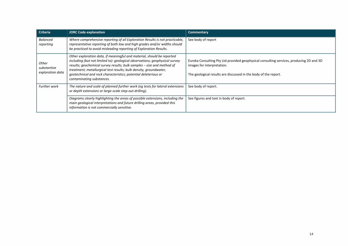
Criteria JORC Code explanation Commentary
Balanced reporting
Where comprehensive reporting of all Exploration Results is not practicable, representative reporting of both low and high grades and/or widths should be practiced to avoid misleading reporting of Exploration Results.
See body of report
Other substantive exploration data
Other exploration data, if meaningful and material, should be reported including (but not limited to): geological observations; geophysical survey results; geochemical survey results; bulk samples – size and method of treatment; metallurgical test results; bulk density, groundwater, geotechnical and rock characteristics; potential deleterious or contaminating substances.
Eureka Consulting Pty Ltd provided geophysical consulting services, producing 2D and 3D images for interpretation. The geological results are discussed in the body of the report.
Further work The nature and scale of planned further work (eg tests for lateral extensions or depth extensions or large-scale step-out drilling).
See body of report.
Diagrams clearly highlighting the areas of possible extensions, including the main geological interpretations and future drilling areas, provided this information is not commercially sensitive.
See figures and text in body of report.


![DIAMOND DRILL HOLE RECORD kife^]fi^i,l-. 7i^?iiL^17-2r^, W ......CONDUCTOR - conductive :one consists of 5164 154.60 155.20 three concordant lassive sulphide 'veins' 5165 155.20 155.50](https://static.fdocuments.net/doc/165x107/602cfa4c06a4885531443554/diamond-drill-hole-record-kifefiil-7iiil17-2r-w-conductor-conductive.jpg)