Strolling to Bollington START and White Nancy
2
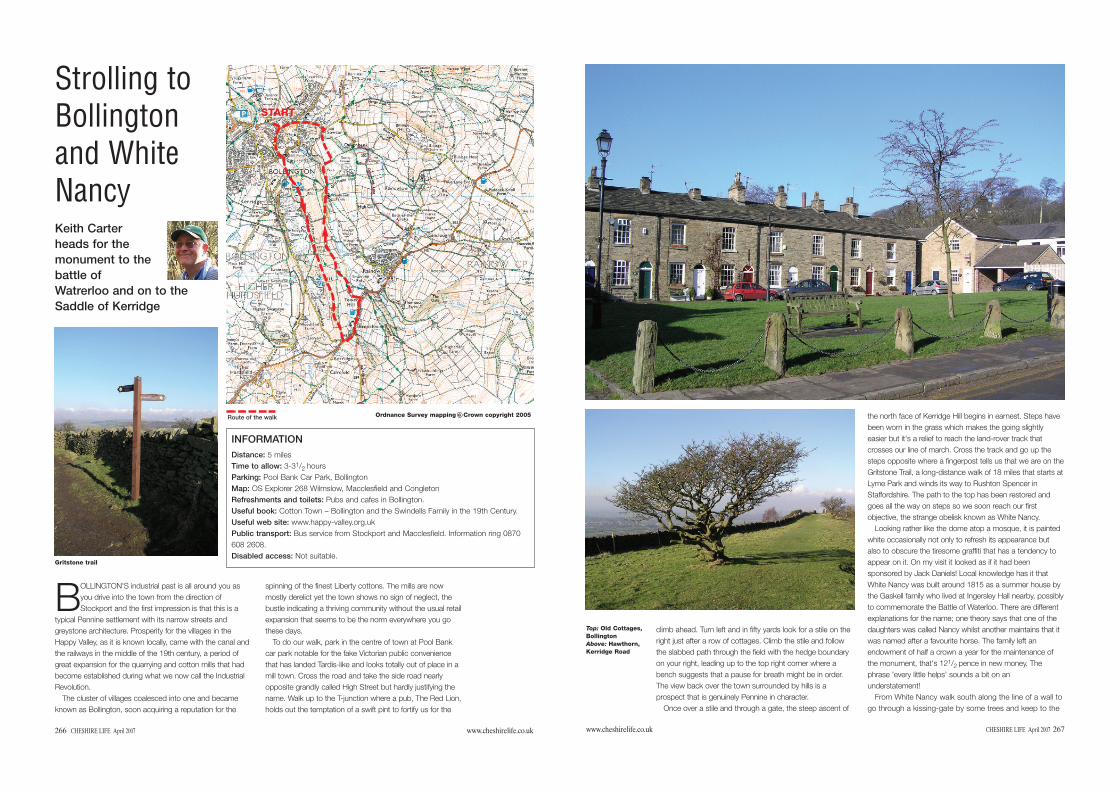
Ordnance Survey mapping Crown copyright 2005 c 266 CHESHIRE LIFE April 2007 www.cheshirelife.co.uk Strolling to Bollington and White Nancy B OLLINGTON'S industrial past is all around you as you drive into the town from the direction of Stockport and the first impression is that this is a typical Pennine settlement with its narrow streets and greystone architecture. Prosperity for the villages in the Happy Valley, as it is known locally, came with the canal and the railways in the middle of the 19th century, a period of great expansion for the quarrying and cotton mills that had become established during what we now call the Industrial Revolution. The cluster of villages coalesced into one and became known as Bollington, soon acquiring a reputation for the spinning of the finest Liberty cottons. The mills are now mostly derelict yet the town shows no sign of neglect, the bustle indicating a thriving community without the usual retail expansion that seems to be the norm everywhere you go these days. To do our walk, park in the centre of town at Pool Bank car park notable for the fake Victorian public convenience that has landed Tardis-like and looks totally out of place in a mill town. Cross the road and take the side road nearly opposite grandly called High Street but hardly justifying the name. Walk up to the T-junction where a pub, The Red Lion, holds out the temptation of a swift pint to fortify us for the Keith Carter heads for the monument to the battle of Watrerloo and on to the Saddle of Kerridge INFORMATION Distance: 5 miles Time to allow: 3-3 1 / 2 hours Parking: Pool Bank Car Park, Bollington Map: OS Explorer 268 Wilmslow, Macclesfield and Congleton Refreshments and toilets: Pubs and cafes in Bollington. Useful book: Cotton Town – Bollington and the Swindells Family in the 19th Century. Useful web site: www.happy-valley.org.uk Public transport: Bus service from Stockport and Macclesfield. Information ring 0870 608 2608. Disabled access: Not suitable. Gritstone trail Route of the walk START START www.cheshirelife.co.uk CHESHIRE LIFE April 2007 267 climb ahead. Turn left and in fifty yards look for a stile on the right just after a row of cottages. Climb the stile and follow the slabbed path through the field with the hedge boundary on your right, leading up to the top right corner where a bench suggests that a pause for breath might be in order. The view back over the town surrounded by hills is a prospect that is genuinely Pennine in character. Once over a stile and through a gate, the steep ascent of the north face of Kerridge Hill begins in earnest. Steps have been worn in the grass which makes the going slightly easier but it's a relief to reach the land-rover track that crosses our line of march. Cross the track and go up the steps opposite where a fingerpost tells us that we are on the Gritstone Trail, a long-distance walk of 18 miles that starts at Lyme Park and winds its way to Rushton Spencer in Staffordshire. The path to the top has been restored and goes all the way on steps so we soon reach our first objective, the strange obelisk known as White Nancy. Looking rather like the dome atop a mosque, it is painted white occasionally not only to refresh its appearance but also to obscure the tiresome graffiti that has a tendency to appear on it. On my visit it looked as if it had been sponsored by Jack Daniels! Local knowledge has it that White Nancy was built around 1815 as a summer house by the Gaskell family who lived at Ingersley Hall nearby, possibly to commemorate the Battle of Waterloo. There are different explanations for the name; one theory says that one of the daughters was called Nancy whilst another maintains that it was named after a favourite horse. The family left an endowment of half a crown a year for the maintenance of the monument, that's 12 1 / 2 pence in new money. The phrase 'every little helps' sounds a bit on an understatement! From White Nancy walk south along the line of a wall to go through a kissing-gate by some trees and keep to the Top: Old Cottages, Bollington Above: Hawthorn, Kerridge Road
Transcript of Strolling to Bollington START and White Nancy
Ordnance Survey mapping Crown copyright 2005c
266 CHESHIRE LIFE April 2007 www.cheshirelife.co.uk
Strolling toBollingtonand WhiteNancy
BOLLINGTON'S industrial past is all around you asyou drive into the town from the direction ofStockport and the first impression is that this is a
typical Pennine settlement with its narrow streets andgreystone architecture. Prosperity for the villages in theHappy Valley, as it is known locally, came with the canal andthe railways in the middle of the 19th century, a period ofgreat expansion for the quarrying and cotton mills that hadbecome established during what we now call the IndustrialRevolution.
The cluster of villages coalesced into one and becameknown as Bollington, soon acquiring a reputation for the
spinning of the finest Liberty cottons. The mills are nowmostly derelict yet the town shows no sign of neglect, thebustle indicating a thriving community without the usual retailexpansion that seems to be the norm everywhere you gothese days.
To do our walk, park in the centre of town at Pool Bankcar park notable for the fake Victorian public conveniencethat has landed Tardis-like and looks totally out of place in amill town. Cross the road and take the side road nearlyopposite grandly called High Street but hardly justifying thename. Walk up to the T-junction where a pub, The Red Lion,holds out the temptation of a swift pint to fortify us for the
Keith Carterheads for themonument to thebattle ofWatrerloo and on to theSaddle of Kerridge
INFORMATIONDistance: 5 milesTime to allow: 3-31/2 hoursParking: Pool Bank Car Park, BollingtonMap: OS Explorer 268 Wilmslow, Macclesfield and CongletonRefreshments and toilets: Pubs and cafes in Bollington.Useful book: Cotton Town – Bollington and the Swindells Family in the 19th Century.Useful web site: www.happy-valley.org.ukPublic transport: Bus service from Stockport and Macclesfield. Information ring 0870608 2608.Disabled access: Not suitable.
Gritstone trail
Route of the walk
STARTSTART
www.cheshirelife.co.uk CHESHIRE LIFE April 2007 267
climb ahead. Turn left and in fifty yards look for a stile on theright just after a row of cottages. Climb the stile and followthe slabbed path through the field with the hedge boundaryon your right, leading up to the top right corner where abench suggests that a pause for breath might be in order.The view back over the town surrounded by hills is aprospect that is genuinely Pennine in character.
Once over a stile and through a gate, the steep ascent of
the north face of Kerridge Hill begins in earnest. Steps havebeen worn in the grass which makes the going slightlyeasier but it's a relief to reach the land-rover track thatcrosses our line of march. Cross the track and go up thesteps opposite where a fingerpost tells us that we are on theGritstone Trail, a long-distance walk of 18 miles that starts atLyme Park and winds its way to Rushton Spencer inStaffordshire. The path to the top has been restored andgoes all the way on steps so we soon reach our firstobjective, the strange obelisk known as White Nancy.
Looking rather like the dome atop a mosque, it is paintedwhite occasionally not only to refresh its appearance butalso to obscure the tiresome graffiti that has a tendency toappear on it. On my visit it looked as if it had beensponsored by Jack Daniels! Local knowledge has it thatWhite Nancy was built around 1815 as a summer house bythe Gaskell family who lived at Ingersley Hall nearby, possiblyto commemorate the Battle of Waterloo. There are differentexplanations for the name; one theory says that one of thedaughters was called Nancy whilst another maintains that itwas named after a favourite horse. The family left anendowment of half a crown a year for the maintenance ofthe monument, that's 121/2 pence in new money. Thephrase 'every little helps' sounds a bit on anunderstatement!
From White Nancy walk south along the line of a wall togo through a kissing-gate by some trees and keep to the
Top: Old Cottages,BollingtonAbove: Hawthorn,Kerridge Road
268 CHESHIRE LIFE April 2007 www.cheshirelife.co.uk
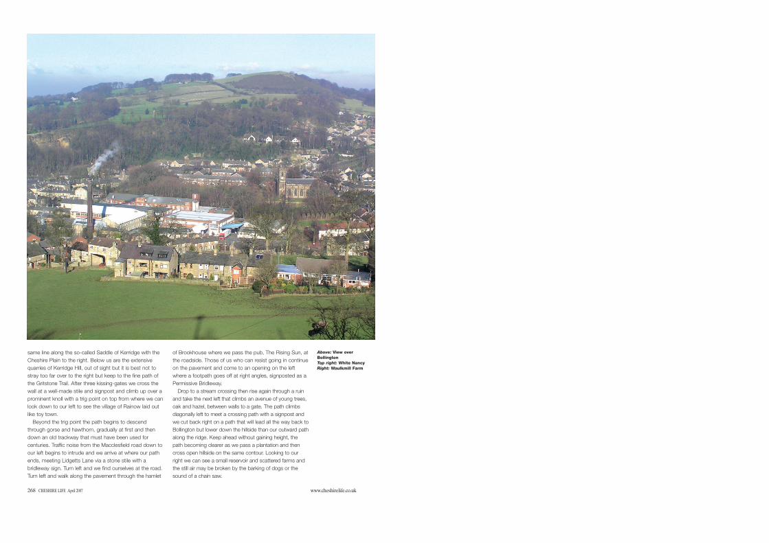
same line along the so-called Saddle of Kerridge with theCheshire Plain to the right. Below us are the extensivequarries of Kerridge Hill, out of sight but it is best not tostray too far over to the right but keep to the fine path ofthe Gritstone Trail. After three kissing-gates we cross thewall at a well-made stile and signpost and climb up over aprominent knoll with a trig point on top from where we canlook down to our left to see the village of Rainow laid outlike toy town.
Beyond the trig point the path begins to descendthrough gorse and hawthorn, gradually at first and thendown an old trackway that must have been used forcenturies. Traffic noise from the Macclesfield road down toour left begins to intrude and we arrive at where our pathends, meeting Lidgetts Lane via a stone stile with abridleway sign. Turn left and we find ourselves at the road.Turn left and walk along the pavement through the hamlet
of Brookhouse where we pass the pub, The Rising Sun, atthe roadside. Those of us who can resist going in continueon the pavement and come to an opening on the leftwhere a footpath goes off at right angles, signposted as aPermissive Bridleway.
Drop to a stream crossing then rise again through a ruinand take the next left that climbs an avenue of young trees,oak and hazel, between walls to a gate. The path climbsdiagonally left to meet a crossing path with a signpost andwe cut back right on a path that will lead all the way back toBollington but lower down the hillside than our outward pathalong the ridge. Keep ahead without gaining height, thepath becoming clearer as we pass a plantation and thencross open hillside on the same contour. Looking to ourright we can see a small reservoir and scattered farms andthe still air may be broken by the barking of dogs or thesound of a chain saw.
Above: View overBollingtonTop right: White NancyRight: Waulkmill Farm