STRATIGRAPHY, SEDIMENTOLOGY AND COAL … Petroleum Resources Hon. Jack Weisgerber, Minister I I...
68
Province of British Columbia Ministry of Energy, Mines and I Petroleum Resources Hon. Jack Weisgerber, Minister I I MINERAL RESOURCES DIVISION Geological Survey Branch STRATIGRAPHY, SEDIMENTOLOGY AND COAL QUALITY OF THE LOWER SKEENA GROUP, TELKWA COALFIELD, CENTRAL BRITISH COLUMBIA, NTS 93L/ll By R. J. Palsgrove and R.M. Bustin PAPER 1991-Z
Transcript of STRATIGRAPHY, SEDIMENTOLOGY AND COAL … Petroleum Resources Hon. Jack Weisgerber, Minister I I...
Province of British Columbia Ministry of Energy, Mines and
I Petroleum Resources Hon. Jack Weisgerber, Minister
I
I
MINERAL RESOURCES DIVISION Geological Survey Branch
STRATIGRAPHY, SEDIMENTOLOGY AND COAL QUALITY OF THE LOWER SKEENA GROUP, TELKWA COALFIELD, CENTRAL BRITISH COLUMBIA, NTS 93L/ll
By R. J. Palsgrove and R.M. Bustin
PAPER 1991-Z
Canadian Cataloguing in Publication Data Palsgrove, RJ.
Stratigraphy, sedimentology and coal quality of the lower Skeena group, Telkwa coalfield, central British Columbia, 93Ull
(Paper, ISSN 02269430 ; 1991-2)
Includes bibliographical references: p. ISBN 0-7718-9032-X
1. Coal - Geology - British Columbia - Telkwa Region. 2. Sedimentology - British Columbia - Telhc Region. 3. Geology, Economic - British Columbia - Telkwa Region. 4. Geology, Stratigraphic. I. Bustin, R Marc. II. British Columbia. Geological Survey Branch. III. British Columbia. Ministry of Energy, Mines and Petroleum Resources. N. Title. V. Series: Paper (British Columbia. Ministry of Energy, Mines and Petroleum Resources) ; 1991-2.
TN806.C32B76 553.2’4’0971182 C91-092170-9
VICTORIA BRITISH COLUMBIA
CANADA
JULY 1991
I
a
I
a
u
I
a
a
Ministry of Energy, Mines and Petroleum Resouxes
TABLE OF CONTENTS Page
ABSTR4CT.. ............................................................................... Vii
INTRODUCI’ION ....................................................................... 1 Location ....................................................................... 1 Data Sources.. .............................................................. 1 Methods.. ...................................................................... 4 Regional Geology and Previous Work.. ................... .4 Local Stratigraphy and
Structure ............................................................... 5
SEDIMENTOLOGY OF THE GOATHORN REGION OF THE TELKWA COALFIELD.. ....................... .9
Unit I Sedimentology .................................................. 9 General Description ............................................ 9 Lithofacies Descriptions.. ................................. 10
Conglomerate ............................................. 10 Massive Sandstone ..................................... 10 Intraclast-rich Sandstone .......................... 11 Argillaceous Sandstone ............................. 11 Carbonaceous Mudstone .......................... 13 Coal.. ............................................................ 13 Fireclay.. ...................................................... 13 Mottled Claystone.. .................................... 14
Depositional Environments of Lithofacies ..... 14 Braided River ............................................. 14 Floodplain ................................................... 14
Depositional History of Unit I ........................ .14 Unit II Sedimentology .............................................. 15
General Description.. ........................................ 15 Lithofacies Descriptions.. ................................. 15
Silty Mudstone.. .......................................... 16 Interbedded Sandstone and Mudstone.. .16 Mottled Argillaceous Sandstone.. ........... .17 Carbonaceous Mudstone .......................... 17 Cross-bedded Sandstone.. ......................... 18
Depositional Environments of Lithofacies ..... 18 Interdistributary Bay.. ................................ 18 Coastal Marsh.. ........................................... 19 Bay Fill.. ....................................................... 19 Distributary Channel ................................. 19
Depositional History of Unit II.. ..................... .19 Unit III Sedimentology ............................................. 20
General Description.. ....................................... .20 Lithofacies Descriptions.. ................................ .21
Silty Mudstone ............................................ 21 Stratified Sandstone.. ................................ .21 Bioturbated Sandstone.. ........................... .21 Carbonaceous Mudstone ......................... .23 Lenticular Bedded Siltstone and
Mudstone.. ........................... .23 Coal.. ........................................................... .23
Page Massive Sandstone .................................... .23
Depositional Environments of Lithofacies .. ...23 Restricted Nearshore Marine.. ................ .24 Intertidal Flat.. ........................................... .24 Upper Intertidal Flat ................................. 24 Coastal Swamp ........................................... 24 Tidal Channel ............................................. 25
Depositional History of Unit III ..................... .25 Unit IV Sedimentology ............................................. 27
General Description .......................................... 27 Lithofacies Descriptions ................................... 27
Green Sandstone ....................................... .27 Silty Mudstone.. ......................................... .27
Depositional Environments of Lithofacies .. ...28 Transgressive Lag ....................................... 28 Quiet Nearshore Marine.. ........................ .28
Depositional History of Unit IV.. ................... .28
STRATIGRAPHY AND SEDIMENTOLOGY OF THE NORTH TELKWA REGION OF THE TELKWA COALFIELD.. ............................................................................ .29
Stratigraphy ................................................................ 29 Depositional Environments ..................................... 30
SANDSTONE PETROGRAPHY AND PROVENANCE.. ....................................................................... .31
Petrography.. ............................................................. .31 Unit I .................................................................. .31 Units II and III ................................................... 31 Unit IV ................................................................ 31
Provenance ................................................................. 32
REGIONAL SIGNIFICANCE OF THE TELKWA COAL MEASURES.. ................................................................ .33
COAL QUALITY - TELKWA COAL SEAMS ........................................................................................ .35
Sulphur Content ........................................................ 35 Stratigraphic Variation in Sulphur Content....3 5
Data ............................................................. 35 Interpretation ............................................ .36
Sulphur Distribution Within Individual Seams.. .............................. .36
Data ............................................................. 36 Interpretation ............................................. 36
Sulphur Forms.. ................................................. .37 Data ............................................................. 37 Interpretation ............................................. 38
Ash Content.. ............................................................ .39 Stratigraphic Variation in Ash Content.. ...... ..3 9
Data ............................................................. 39 Interpretation ............................................. 39
,
Paper 1991-2 . . . 111
Btitish Columbia
Page Ash Distribution Within Individual Seams.. . ..3 9
Data .............................................................. 39 Interpretation .............................................. 42
CONCLUSIONS ......................................................................... 43 Acknowledgments .................................................... .44
REFERENCES ........................................................................... 45
APPENDICES I. Results of Palynological Analyses.. ......................... .49
II. Results of Paleontological Analyses ....................... .57
III. Typical Sandstone Composition of Lower Skeena Group ............................................................ 59
FIGURES 1. Location of study area.. ............................................... .l 2. Drillhole maps of the Goathorn and North Telkwa
regions of the Telkwa coalfield, showing location of cross-sections ............................................................ 2
3. Drillhole maps of the Goathorn and North Telkwa regions of the Telkwa coalfield, showing location of isopach maps and ash and sulphur distribution maps.. ............................................................................. .3
4. Tectonic elements of Br,itish Columbia.. .................... .4
5. Nomenclature for Cretaceous sediments in central British Columbia .............................................. 5
6. Cross-section showing offset of Unit I.. ..................... .6
7. Representative sections of the Lower Skeena Group in the Goathorn region of the Telkwa coalfield.. ....................................................................... .7
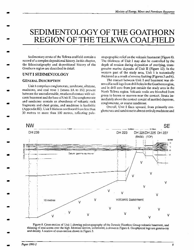
8. Cross-section of Unit 1 showing paleotopography of the Jurassic Hazelton Group volcanic basement, and thinning of coal seams.. ........................................ .9
9. Fence diagram of Unit I showing lithofacies distribution.. ................................................................ .10
10. Isopach map of combined thickness of 3 major coal seams in coal zone 1 .......................................... .10
11. Depositional environment of Unit I .......................... 15 12. Cross-section through Unit II showing lithofacies
distribution.. ................................................................ .16
13. Depositional environment of Unit II ....................... .19
14. a) Cross-section through Unit III showing lithofacies distribution; b) Location of cross- section in Figure 14a.. ................................................ .20
15. Shoreline related peat-forming environments.........2 5 16. Distribution of coal zones in Unit III.. ..................... .26
17. Isopach maps of coal zones 4 and 5 (combined), and of the sandstone immediately underlying the coal zones ..................................................................... 26
Page 18. Depositional environment of Unit III . . . . . . . . . . . . . . . . . . . . . . . 27 19. Cross-section of the North Telkwa region of the
Telkwa coalfield . . . . . . . . . . . . . . . . . . . . . . . . . . . . . . . . . . . . . . . . . . . . . . . . . . . . . . . . . . . 29
20. Range in total sulphur content of each seam in Unit III (raw and washed) . . . . . . . . . . . . . . . . . . . . . . . . . . . . . . . . . . . . . . . . . . 35
21. Raw total sulphur content of seam 3U relative to the presence or absence of brackish, tidal flat sandstone above it . . . . . . . . . . . . . . . . . . . . . . . . . . . . . . . . . . . . . . . . . . . . . . . . . . . . . . 36
22. Sulphur content of seam 9 relative to the thickness of terrestrial sediments between the seam and marine sediments of Unit IV . . . . . . . . . . . . . . . . . . . . 36
23. Plot of raw total sulphur content versus washed total sulphur content for coal zone 2 . . . . . . . . . . . . . . . . . . . . . . . . 37
24. Plot of raw total sulphur content versus washed total sulphur content for coal zone 3 . . . . . . . . . . . . . . . . . . . . . . . . 37
25. Plot of raw total sulphur content versus washed total sulphur content for coal zones 4 and 5 . . . . . . . . . . . . 38
26. Plot of raw total sulphur content versus washed total sulphur content for coal zones 6 and 7 . . . . . . . . . . . . 38
27. Plot of raw total sulphur content versus washed total sulphur content for coal zones 8,9, and 10 . . ...39
28. Per cent ash distribution within coal zone 2 . . . . . . . . . . . . . 40 29. Per cent ash distribution within coal zone 3 . . . . . . . . . . . . . 40
30. Per cent ash distribution within coal zones 4 and 5 . . . . . . . . . . . . . . . . . . . . . . . . . . . . . . . . . . . . . . . . . . . . . . . . . . . . . . . . . . . . . . . . . . . . . . . . . . . . . . 41
31. Per cent ash distribution within coal zones 6 and 7 . . . . . . . . . . . . . . . . . . . . . . . . . . . . . . . . . . . . . . . . . . . . . . . . . . . . . . . . . . . . . . . . . . . . . . . . . . . . . . 41
32. Per cent ash distribution within coal zones 8, 9, and 10 . . . . . . . . . . . . . . . . . . . . . . . . . . . . . . . . . . . . . . . . . . . . . . . . . . . . . . . . . . . . . . . . . . . . 41
TABLES 1. Major compositional differences between
sandstones of Units I, II, III and IV . . . . . . . . . . . . . . . . . . . . . . . . . . 32 2. Typical coal quality of coal from the Telkwa
coalfield . . . . . . . . . . . . . . . . . . . . . . . . . . . . . . . . . . . . . . . . . . . . . . . . . . . . . . . . . . . . . . . . . . . . . . . . 35 3. Ash content of seams in Unit III ..a............................ 39
PLATES 1. a) Conglomerate lining-upward sequence;
b) Rooted sandstone . . . . . . . . . . . . . . . . . . . . . . . . . . . . . . . . . . . . . . . . . . . . . . . . . . . 11
2. a) Intraclast-rich sandstone; b) Intraclast-rich sandstone with large rounded mudclasts; c) Soft sediment deformation; d) Argillaceous sandstone . . . . . . . . . . . . . . . . . . . . . . . . . . . . . . . . . . . . . . . . . . . . . . . . . . . . . . . . . . . . . . . . . . . . . . 12
3. a) Carbonaceous mudstone with plant fossils; b) Seatearth . . . . . . . . . . . . . . . . . . . . . . . . . . . . . . . . . . . . . . . . . . . . . . . . . . . . . . . . . . . . . . . . . . 13
4. Mottled claystone . . . . . . . . . . . . . . . . . . . . . . . . . . . . . . . . . . . . . . . . . . . . . . . . . . . . . . . . 13 5. a) Silty mudstone with Heltnittthopsis trace
fossils; b) Ophiotnotpha trace fossil . . . . . . . . . . . . . . . . . . . . . . . . . . 17
iv Geological Survey Bmnch
1111
m
(II,
I
I
1
(I
a
Ministty of Energy, Mines and Petroleum Resources
Page 6. a) Boring bivalves @redo) in fossilized wood;
b) Interbedded sandstone and mudstone with Planolites and Skolithos trace fossils . . . . . . . . . . . . . . . . . . . . . . . . 17
7. Calcium carbonate concretions . . . . . . . . . . . . . . . . . . . . . . . . . . . . . . . . 17
8. a) Macaronichnus trace fossils; b) Mottled argillaceous sandstone with Rosselia trace fossil; c) Cross-bedded sandstone . . . . . . . . . . . . . . . . . . . . . . . . . . . . . . . . . . . . . . . 18
9. Wavy-bedded sandstone . . . . . . . . . . . . . . . . . . . . . . . . . . . . . . . . . . . . . . . . . . . . . 21
10. a) Teichichnus trace fossil in bioturbated sandstone; b) Zoophycus trace fossil in bioturbated sandstone;
Page c) Syneresis cracks in lenticular-bedded siltstone and mudstone . . . . . . . . . . . . . . . . . . . . . . . . . . . . . . . . . . . . . . . . . . . . . . . . . . . . . . . . . . . . . . 22
11. a) Cycad fossil in lenticular-bedded siltstone and mudstone; b) Algal mats in lenticular-bedded siltstone and mudstone . . . . . . . . . . . . . . . . . . . . . . . . . . . . . . . . . . . . . . . . . . . . . . . 23
12. Photomicrograph of algal mats . . . . . . . . . . . . . . . . . . . . . . . . . . . . . . . . . 23 13. a) Hexagonal, monocrystalline, corroded
‘volcanic’ quartz grain; b) Volcanic rock fragment . . . . . . . . . . . . . . . . . . . . . . . . . . . . . . . . . . . . . . . . . . . . . . . . . . . . . . . . . . . . . . . . . . . . . . . 31
Paper 1991-2 V

Btitish Columbia
vi Geological Survey Bmnch
m
Ministry of Energy, Mines and Pebvleum Resoumes
ABSTRACT
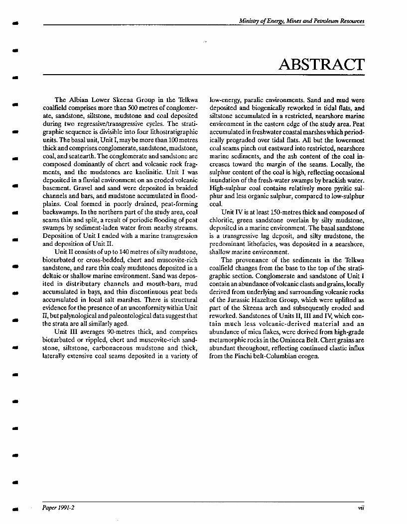
The Albian Lower Skeena Group in the Telkwa coaltield comprises more than 500 metres of conglomer- ate, sandstone, siltstone, mudstone and coal deposited during two regressive/transgressive cycles. The strati- graphic sequence is divisible into four lithostratigraphic units. The basal unit, Unit I, may be more than 100 metres thick and comprises conglomerate, sandstone, mudstone, coal, and seatearth. The conglomerate and sandstone are composed dominantly of chert and volcanic rock frag- ments, and the mudstones are kaolinitic. Unit I was deposited in a fluvial environment on an eroded volcanic basement. Gravel and sand were deposited in braided channels and bars, and mudstone accumulated in flood- plains. Coal formed in poorly drained, peat-forming backswamps. In the northern part of the study area, coal seams thin and split, a result of periodic flooding of peat swamps by sediment-laden water from nearby streams. Deposition of Unit I ended with a marine transgression and deposition of Unit II.
Unit II consists of up to 140 metres of silty mudstone, bioturbated or cross-bedded, chert and muscovite-rich sandstone, and rare thin coaly mudstones deposited in a deltaic or shallow marine environment. Sand was depos- ited in distributary channels and mouth-bars, mud accumulated in bays, and thin discontinuous peat beds accumulated in local salt marshes. There is structural evidence for the presence of an unconformity within Unit II, but palynological and paleontological data suggest that the strata are all similarly aged.
Unit III averages 90-metres thick, and comprises bioturbated or rippled, chert and muscovite-rich sand- stone, siltstone, carbonaceous mudstone and thick, laterally extensive coal seams deposited in a variety of
low-energy, paralic environments. Sand and mud were deposited and biogenically reworked in tidal flats, and siltstone accumulated in a restricted, nearshore marine environment in the eastern edge of the study area. Peat accumulated in freshwater coastal marshes which period- ically prograded over tidal flats. All but the lowermost coal seams pinch out eastward into restricted, nearshore marine sediments, and the ash content of the coal in- creases toward the margin of the seams. Locally, the sulphur content of the coal is high, reflecting occasional inundation of the fresh-water swamps by brackish water. High-sulphur coal contains relatively more pyritic sul- phur and less organic sulphur, compared to low-sulphur coal.
Unit IV is at least 150-metres thick and composed of chloritic, green sandstone overlain by silty mudstone, deposited in a marine environment. The basal sandstone is a transgressive lag deposit, and silty mudstone, the predominant lithofacies, was deposited in a nearshore, shallow marine environment.
The provenance of the sediments in the Telkwa coalfield changes from the base to the top of the strati- graphic section. Conglomerate and sandstone of Unit I contain an abundance of volcanic clasts and grains, locally derived from underlying and surrounding volcanic rocks of the Jurassic Hazelton Group, which were uplifted as part of the Skeena arch and subsequently eroded and reworked. Sandstones of Units II, III and IV, which con- tain much less volcanic-derived material and an abundance of mica flakes, were derived from high-grade metamorphic rocks in the Omineca Belt. Chert grains are abundant throughout, reflecting continued elastic influx from the Pinchi belt-Columbian orogen.
I Paper 1991-2 vii

British Columbia
. . . VIII Geological Survey Branch
II
m
E
Ministty of Energy, Mines and Petroleum Resomes
INTRODUCTION
Significant coal resources occur in the Lower Creta- ceous Skeena Group near the town of Telkwa in central British Columbia. The coal deposits have been mined on a small scale since the early 19OOs, and a major explora- tion project to delineate further exploitable coal reserves was initiated in the 1980s (Handy and Cameron, 1983). Early attempts to resolve the lithostratigraphy and inter- pret the depositional history of the coal measures were hampered by the lack of outcrops and subsurface infor- mation. As a result of recent exploration, a large number of drill cores, geophysical logs and coal quality data are now available, facilitating a detailed sedimentological and coal-quality study of the coal measures.
The objectives of this study are: 1) to describe and define the stratigraphy and lateral facies changes of the coal measures in the Skeena Group; 2) to interpret the depositional histoe of coal measures in the Telkwa area; and 3) to relate the coal quality to depositional environ-
6065500m N
,. SKEENA GROUP SEDIMENTS (Cretaceous)
Id HAZELTON GROUP VOLCANICS (Jurassic)
lXI INTRUSIVES (Late Cretaceous or Eocene) .... FAULT (assumed)
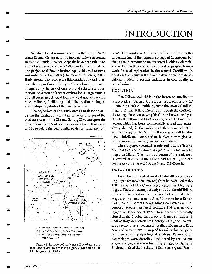
Figure 1. Location of study area. Boxed areas arc locations of drillhole maps in Figure 2. Modified after MacIntyre et al. (1989).
ment. The results of this study will contribute to the understanding of the regional geology of Cretaceous ba- sins in the Intermontane Belt in central British Columbia, and will aid in the development of a stratigraphic frame- work for coal exploration in the central Cordillera. In addition, the results will aid in the development of depo- sitional models to predict variations in coal quality in other basins.
LOCATION The Telkwa coalfield is in the Intermontane Belt of
west-central British Columbia, approximately 18 kilometres south of Smithers, near the town of Telkwa (Figure 1). The Telkwa River runs through the coalfield, dissecting it into two geographical areas known locally as the North Telkwa and Goathorn regions. The Goathorn region, which has been commercially mined and exten- sively drilled, is the subject of this research. The sedimentology of the North Telkwa region will be dis- cussed briefly and compared to the Goathorn region, as coal seams in the two regions are correlatable.
The study area (hereinafter referred to as the ‘Telkwa coalfield’) comprises about 24 square kilometres in NTS map area 93Wll. The northwest corner of the study area is located at 6 057 OOOm N and 619 OOOm E, and the southeast corner at 6 051500m N and 623 OOOm E.
DATA SOURCES From June through August of 1989,40 cores (total-
ling approximately 4500 metres) from holes drilled in the Telkwa coalfield by Crows Nest Resources Ltd. were logged. These cores are presently stored at the old Telkwa mine site. Five additional cores (from holes drilled in late August in the same area by Alex Matheson for a British Columbia Ministry of Energy, Mines, and Petroleum Re- sources research project) totalling 300 metres were logged in December of 1989. These cores are presently stored at the Geological Survey of Canada Institute of Sedimentary and Petroleum Geology in Calgary. Ten out- crop sections were measured, totalling 100 metres. Drill core and outcrops were sampled for mineralogical, pale- ontological and palynological analysis. Palynomorph assemblages were described and dated by Dr. Arthur Sweet, and trigonid macrofossils were dated by Dr. Terry Poulton; both of the Institute of Sedimentary and Petro-
Paper 199X-2 1
British Columbia
NORTH TELKWA REGION
6059500m N
W
E
z QI
6
GOATHORN REGION
I ,’ ,’ /.. I ‘2 *IQ A r’
no *
n l
6051OOOm N
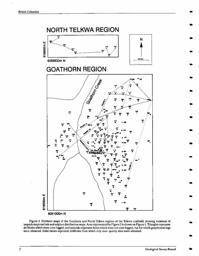
Figure 2. Drillhole maps of the Goathom and North Telkwa regions of the Telkwa coalfield, showing locations of isopach maps and ash and sulphur distriiution maps. Area represented by Figure 2 is shown on Figure 1. Triangles represent drillholes which were core-logged, and asterisks represent holes which were not core-logged, but for which geophysical logs were obtained. Solid circles represent drillholes from which only coal- quality data were obtained.
2 Geological Swvey Bmnch
Ministty of Energy, Mines and Petroleum Resources
NORTH TELKWA REGION
6059500m N 0.5 km
GOATHORN REGION
---
T I I
I I I
*A I
I
eI/
I
I I I I I
: 1 I I I I I I I I I I I I I
6051000m N
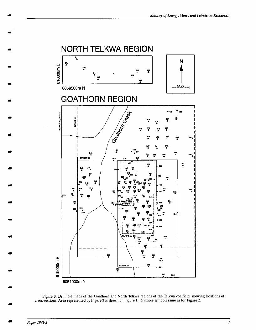
Figure 3. Drillhole maps of the Goathorn and North Telkwa regions of the Telkwa coalfield, showing locations of cross-sections. Area represented by Figure 3 is shown on Figure 1. Drillhole symbols same as for Figure 2.
Paper 1991-2 3
British Columbia
leum Geology (Sweet, G.S.C. Report AS-90-01, Appen- dix I; Poulton, G.S.C. Report J-lo-1990-TPP, Appendii II).
Geophysical well logs (gamma-ray/long-spaced den- sity or ‘coal lithology’, and gamma-ray/neutron density) from 43 additional holes were examined to supplement the core and outcrop data. Four shallow reflection-seis- mic profiles were obtained from the Coal Mining Research Company. The profiles are confidential but structural interpretations made from these profiles are discussed in this paper. Coal-quality data obtained from Crows Nest Resources Ltd. includes raw and washed total sulphur and ash content of seams in coal zones two through ten, from 125 drillholes.
Figures 2 and 3 show the location of drillholes in the study area from which core logs and geophysical logs were obtained. The seismic profiles trend north-south and west-east through the middle of the study area.
METHODS Detailed stratigraphic columns were compiled from
data from all measured core and outcrops. Descriptions of drill core were at a decimetre scale and included, sedimentary and biogenic structures, fossil content, color, bedding angles, and grain composition, size, rounding and sorting. Using core logs, nineteen stratigraphic cross- sections were constructed, five of which are presented in this paper. Cross-sections do not extend to the eastern edge of the study area, where the strata are more com- plexly deformed.
Isopach, iso-sulphur and iso-ash maps were con- structed. Thicknesses for coal isopach maps were measured from wireline logs. Coal thicknesses could not be obtained from drill core, as most of the coal in the core had been removed for analyses. For sandstone isopach maps, sandstone thicknesses were measured from drill core.
Sandstone petrography was determined from exam- ination of nine thin sections and several hand specimens, and clay mineralogy was determined by x-ray diffraction analysis. Wherever possible, lithological interpretations are based on core logs instead of geophysical logs. Lith- ological interpretation from geophysical logs, aside from the recognition of coal seams, proved difficult due to poor definition of the typically argillaceous and volcanogenic sandstones in the Telkwa coalfield. Unfortunately, most of the core from the lower coal-bearing unit is in poor condition as a result of being stored outside. Therefore, lithological and depositional interpretations of the lower
M = Meaozoc
P = Paleozouc and Proterozoic
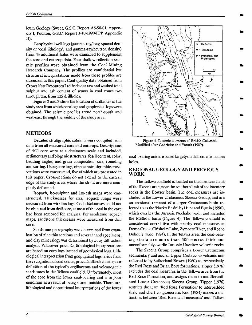
Figure 4. Tectonic elements of British Columbia. Modified after Gabrielse and Yorath (1989).
coal-bearing unit are based largely on drill core from nine holes.
REGIONAL GEOLOGY AND PREVIOUS WORK
The Telkwa coallield is located on the northern flank of the Skeena arch, near the southern limit of sedimentary rocks in the Bowser basin. The coal measures are in- cluded in the Lower Cretaceous Skeena Group, and are an erosional remnant of a larger Cretaceous basin re- ferred to as the ‘Nazko Basin’ by Hunt and Bustin (1990), which overlies the Jurassic Nechako basin and includes the Methow basin (Figure 4). The Telkwa coalfield is considered correlative with nearby coal measures at Denys Creek, Chisholm Lake, Zymoetz River, and Roche Deboule (Koo, 1984). In the Telkwa area, the coal-bear- ing strata are more than SOO-metres thick and unconformably overlie Jurassic Hazelton volcanic rocks.
The Skeena Group comprises a Lower Cretaceous sedimentary unit and an Upper Cretaceous volcanic unit referred to by Sutherland Brown (1960) as, respectively, the Red Rose and Brian Boru formations. Tipper (1976) excludes the coal measures in the Telkwa area from the Red Rose Formation, and assigns them to undifferenti- ated Lower Cretaceous Skeena Group. Tipper (1976) restricts the term ‘Red Rose Formation’ to interbedded shale and chert conglomerate. Koo (1984) makes a dis- tinction between ‘Red Rose coal measures’ and ‘Telkwa
4 GeoIogical Survey Branch
Ministry of Enemy, Mines and Petmleum Resotmes
LEACH ARMSTRONG 1910 1944
SLJTHERLAND BROWN 1960
TIPPER AND RICHARDS
TIPPER 1976
V E. Cwt. w Later vdc. div.
V
V pm- M. Jur. vok. tiiv
”
V
V 1 V
V
KITSUN CREEK SEDIMENTS pdymkmngl;
pyw sh; coel; minor MT.
n
Figure 5. Nomenclature for Cretaceous sediments in central British Columbia. Ab = abundant, bur = burrows, talc = calcareous, ch = chert, congl = conglomerate, Cret = Cretaceous, div = division, E = Early, fsp = feldspar, greyw = greywacke, Jur = Jurassic, L = Late, M = Medial, micac = micaceous, OR = organic-rich, peb = pebble, polymic = polymictic, rip = ripples, sed = sedimentary, sh = shale, ss = sandstone, volt = volcanic, volt RF = volcanic rock fragment.
coal measures’, and proposes the term ‘Early Cretaceous Skeena coal measures’ for all coalfields in the Skeena arch area. MacIntyre et al. (1989) include the Telkwa coal measures in the Red Rose Formation. In this discussion, to avoid confusion, the sediments of the Telkwa coalfield are referred to as Lower Skeena Group. Figure 5 summa- rizes several published stratigraphic nomenclatures for the Skeena Group.
Deposition of Skeena Group sediments began during the Early Cretaceous, following regional uplift and ero- sion of the Skeena arch. The sediments of the Skeena Group were transported southwest across the arch from the Pinchi belt and Columbian orogen (Tipper and Rich- ards, 1976). Sediments of the Lower Skeena Group are marine or continental and coal-bearing, and typically contain an abundance of fine-grained detrital muscovite (Leach, 1910; Sutherland Brown, 1960; Tipper and Rich- ards, 1976).
LOCAL STRATIGRAPHY AND STRUCTURE
The Telkwa coalfield is in fault contact on all sides with the Lower Jurassic Telkwa Formation of the Hazel- ton Group (MacIntyre et al., 1989). Displacements on the
faults are primarily vertical and are estimated between 50 and 300 metres (Koo, 1983). In addition, several northeast and northwest striking high-angle faults dissect the coalfield. Recently obtained seismic data indicate that the Hazelton Group basement and lowermost coal-bearing strata in the western portion of the study area are offset by a nearly vertical north striking fault with an apparent displacement of approximately 80 metres (Figure 6). The upper coal-bearing strata are not cut by this fault, suggest- ing that an unconformity is present within the section. Minor near-vertical faults slightly displace the upper coal-bearing strata. In the southeastern corner of the coalfield, northwest striking low-angle reverse faults are present, and strata in this area are very disrupted. Steeply dipping beds occur locally, and strata are repeated in some drill holes. The seismic profiles have poor resolu- tion in the vicinity of these faults, so the dip angles and magnitudes of throw are difficult to ascertain. However, they have an apparent dip of approximately 450 with displacements of 10 to 30 metres.
Porphyritic Late Cretaceous and Eocene dikes and sills intrude the coal measures throughout the coallield, and a large granodiorite and quartz monzonite intrusion is present in the North Telkwa region (Koo, 1983). Locally
Paper 1991-2 5
Btitish Columbia
- r 0.15km 7 SE DH 225 DH 227
NW I DH 239
v
volcanic basement
Figure 6. Cross-section showing offset of Unit I. Coal zone 1 is repeated in drillhole 22.5. Thd identical section, restored, is shown in Figure 8. Geophysical logs are gamma-ray and density. Location of cross-section shown in Figure 3.
these igneous intrusions significantly affect the organic petrology of the coal (Goodarzi and Cameron, 1989).
More than 500 metres of Lower Skeena Group strata unconformably overly Hazelton Group volcanic rocks. Plant fossils found in Skeena Group sedimentary rocks in the Telkwa coalfield were dated as Early Cretaceous by Hacquebard et al. (1967). Palynomorph assemblages from the lower and upper coal-bearing units indicate that the strata are early Albian or possibly Aptian or Barrem- iau in age (Sweet, G.S.C. Report AS-90-01, Appendix I). The presence of Distaltriangulatisporites sp. in the upper coal-bearing unit may indicate that the age of this unit to middle or late Albian (G. Rouse, personal communica- tion). Trigonids from the marine unit between the lower
and upper coal-bearing units are Albian or as old as Barremian (Poulton, G.S.C. Report J-lo-1990-TPF’, Ap- pendix II).
Within most of the study area, the stratigraphic suc- cession is divisible into four informal units based upon gross lithology (Figure 7). Coal occurs in ten ‘zones’ (Handy and Cameron, 1983); each zone is named for one or more seams split by an organic-rich mudstone that is less than or equal to the thickness of the coal seams themselves. An exception is coal zone 1, in which all the laterally correlatable seams are grouped as one zone, despite the fact that the seams may be separated by as much as 8 metres of carbonaceous mudstone.
6 Geological Survey Brunch
Ministry of Energy, Mines and Petroleum Resources
.~ HAZELTON
GROUP (Jurassic)
. . . ~~. _ . . . . .* i : ., coarserung-upward sequence
,.. ,. .
.~ (regional marker) .~’
. . . . . . . . . . . .
c-- I “ertlcal scale: . . . .*._ 50m
7. ..1 1 -I--J sandstone
l,:-“:11 conglomerate i- ,~ -v vy volcanic
Figure 7. Representative sections of the Lower Skeena Group in the Goathom region of the Telkwa coalfield.
The four lithological units defined in this study cor- respond to those defined by Handy and Cameron (1983), and the three lowest units correspond roughly to those recognized by Koo (1983). The lowermost unit (Unit I) unconformably overlies volcanic basement and consists of fine to coarse-grained crossbedded sandstone, con- glomerate, siltstone, mudstone and coal (coal zone 1). The conglomerate and sandstone contain an abundance of volcanic rock fragments and chert, and the mudstone is kaolinitic (Appendix III). Coal zone 1 contains a highly radioactive interval which is a regional marker on gamma- ray logs. Unit II overlies coal zone 1 and consists primarily of a monotonous silty mudstone, with occasional siltstone and sandstone beds. Sandstone is chert-rich and mica- ceous (Appendix III). The top of Unit II is defined by a 10 to 15 metre coarsening-upward sequence that serves as a regional marker on geophysical logs. Unit III, which overlies the coarsening-upward sequence, comprises chert-rich, micaceous sandstone, siltstone and mudstone (Appendix III), and up to nine coal zones (coal zones 2 through 10) . The uppermost unit, Unit IV, overlies coal zone 10 and is characterized by a monotonous silty mud- stone similar to that in Unit II. A 2 to 4-metre thick bright green chloritic sandstone or siltstone marks the base of Unit IV and serves as a regional marker (Appendix III).
The stratigraphic succession changes markedly from west to east (Figure 7). Toward the eastern margin of the study area, Unit III lacks sandstone and contains only the two lowest coal zones (coal zones 2 and 3).
I Paper 1991-2 7
Bn’tish Columbia
8 Geological Survey Bmnch
Ministry of Energy, Mines and Petroleum Resounxs
SEDIMENTOLOGY OF Tl.!IE GOATHORN REGION OF THE TELKWA COALFIELD
Sedimentary strata of the Telkwa coalfield contain a record of a complex depositional history. In this chapter, the lithostratigraphy and depositional history of the Goathorn region are described in detail.
UNIT I SEDIMENTOLOGY
GENERAL DESCRIPTION Unit I comprises conglomerate, sandstone, siltstone,
mudstone, and coal zone 1 (seams 1A to 1G) present between the unconformable, weathered contact with vol- canic basement and the base of Unit II. The conglomerate and sandstone contain an abundance of volcanic rock fragments and chert grains, and mudstone is kaolinitic (Appendix III). Unit I thickens northward from less than 30 metres to more than 100 metres, reflecting pale-
NW SE DH 239
1.6km --
otopographic relief on the volcanic basement (Figure 8). The thickness of Unit I may also be controlled by the depth of erosion during deposition of overlying, trans- gressive marine deposits of Unit II (Figure 12). In the western part of the study area, Unit I is tectonically thickened as a result of reverse faulting (Figures 5 and 6).
The contact between Unit I and basement was ob- served in well logs from drill holes in the Goathorn region, and in drill core from just outside the study area in the North Telkwa region. Volcanic rocks are bleached from green to brown or maroon near the contact. Strata im- mediately above the contact consist of mottled claystone, conglomerate, or coarse sandstone.
Overall, Unit I fines upward, from primarily con- glomerate and sandstone to almost entirelymudstone and
~--, ,- O&km - i 0.15km -
DH 223 DH 225DH 225 DH 227 (BASE) (TOP)
Datum: gamma ray marker
volcanic basement
Figure 8. Cross-section of Unit 1 showing paleotopography of the Jurassic Hazelton Group volcanic basement, and thinning of coal seams over the high. Identical section, unrestored, is shown in Figure 6. Geophysical logs are gamma-ray and density. Location of cross-section shown in Figure 3.
Paper 1991-2 9
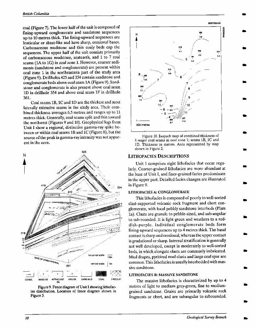
Bnlish Columbia
coal (Figure 7). The lower half of the unit is composed of fining-upward conglomerate and sandstone sequences up to 10 metres thick. The fining-upward sequences are lenticular or sheet-like and have sharp, erosional bases. Carbonaceous mudstone and thin coaly beds cap the sequences. The upper half of the unit consists primarily of carbonaceous mudstone, seatearth, and 1 to 7 coal seams (IA to 1G) in coal zone 1. However, coarser sedi- ments (sandstone and conglomerate) are present within coal zone 1 in the northeastern part of the study area (Figure 9). Drillholes 425 and 354 contain sandstone and conglomerate beds above coal seam lA (Figure 9). Sand- stone and conglomerate is also present above coal seam 1D in drillhole 354 and above coal seam 1F in drillhole 361.
Coal seams lB, 1C and 1D are the thickest and most laterally extensive seams in the study area. Their com- bined thickness averages 6.5 metres and ranges up to 11 metres thick. Generally, coal seams split and thin toward the northwest (Figures 9 and 10). Geophysical logs from Unit I show a regional, distinctive gamma-ray spike be- tween or within coal seams 1B and 1C (Figure S), but the source of the peak in gamma-ray intensity was not appar- ent in the core.
425 N /A
CONGL MASS SS INTRACLAST ARG SS CARS MUD COAL FIRECLAY ss
Figure 9. Fence diagram of Unit I showing lithofac- ies distribution. Location of fence diagram shown in Figure 3.
I 500 m&es
Figure 10. Isopach map of combined thickness of 3 major coal seams in coal zone 1; seams lB, 1C and 1D. Thickness in metres. Area represented by map shown in Figure 2.
LITHOFACIESDESCRIPTIONS Unit I comprises eight lithofacies that occur regu-
larly. Coarser-grained lithofacies are more abundant at the base of Unit I, and finer-grained facies predominate in the upper part. Detailed facies changes are illustrated in Figure 9.
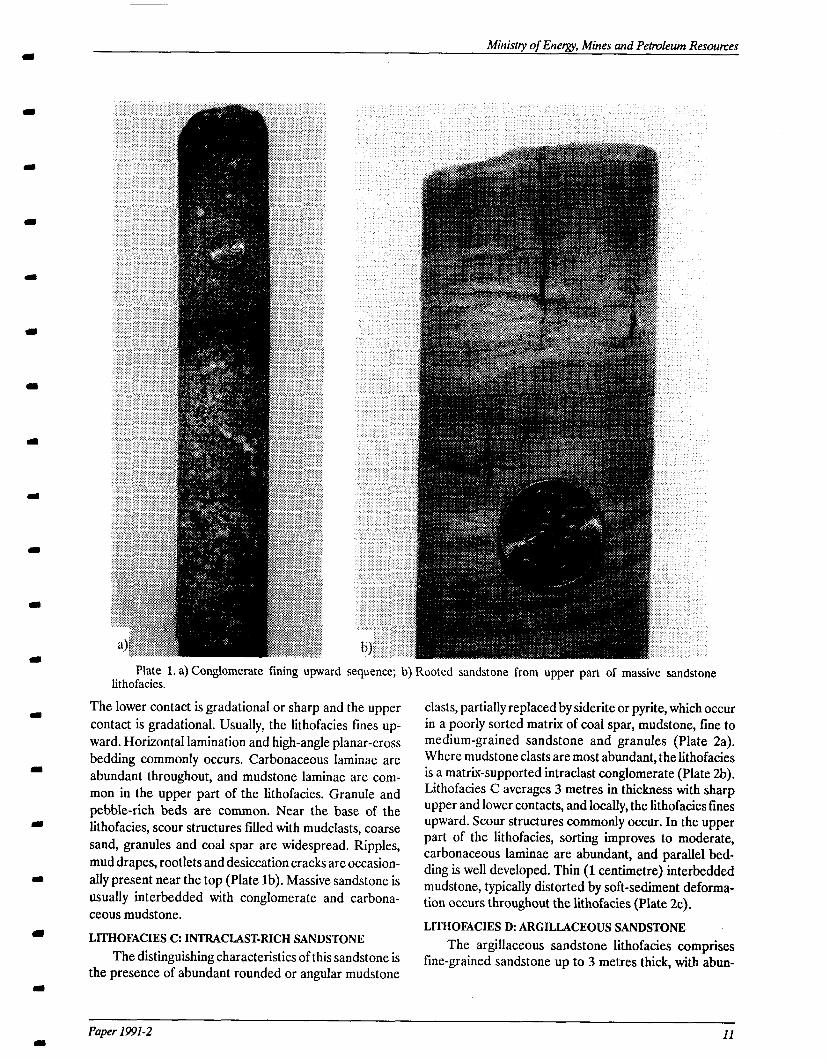
LITHOFACIES A: CONGLOMERATE
This lithofacies is composed of poorly to well-sorted clast-supported volcanic rock fragment and chert con- glomerate, with local pebbly sandstone interbeds (Plate la). Clasts are granule to pebble-sized, and sub-angular to sub-rounded. It is light green and weathers to a red- dish-purple. Individual conglomerate beds form fining-upward sequences up to 4 metres thick. The basal contact is sharp and erosional, whereas the upper contact is gradational or sharp. Internal stratification is generally not well developed, except in moderately to well-sorted beds, in which elongate clasts are commonly imbricated. Mud drapes, pyritized mud clasts and large coal spar are common. This lithofacies is usually interbeddedwith mas- sive sandstone.
LITHOFACIES B: MASSIVE SANDSTONE
The massive lithofacies is characterized by up to 4 metres of light to medium grey-green, fine to medium- grained sandstone. Grains are primarily volcanic rock fragments or chert, and are subangular to subrounded.
10 Geological Sutvey Bmnch
Ministry of Energy, Mines and Petmleum Resources
Plate 1. a) Conglomerate fining upward sequence; b) Rooted sandstone from upper part of massive sandstone lithofacies.
The lower contact is gradational or sharp and the upper contact is gradational. Usually, the lithofacies fines up- ward. Horizontal lamination and high-angle planar-cross bedding commonly occurs. Carbonaceous laminae are abundant throughout, and mudstone laminae are com- mon in the upper part of the lithofacies. Granule and pebble-rich beds are common. Near the base of the lithofacies, scour structures filled with mudclasts, coarse sand, granules and coal spar are widespread. Ripples, mud drapes, rootlets and desiccation cracks are occasion- ally present near the top (Plate lb). Massive sandstone is usually interbedded with conglomerate and carbona- ceous mudstone.
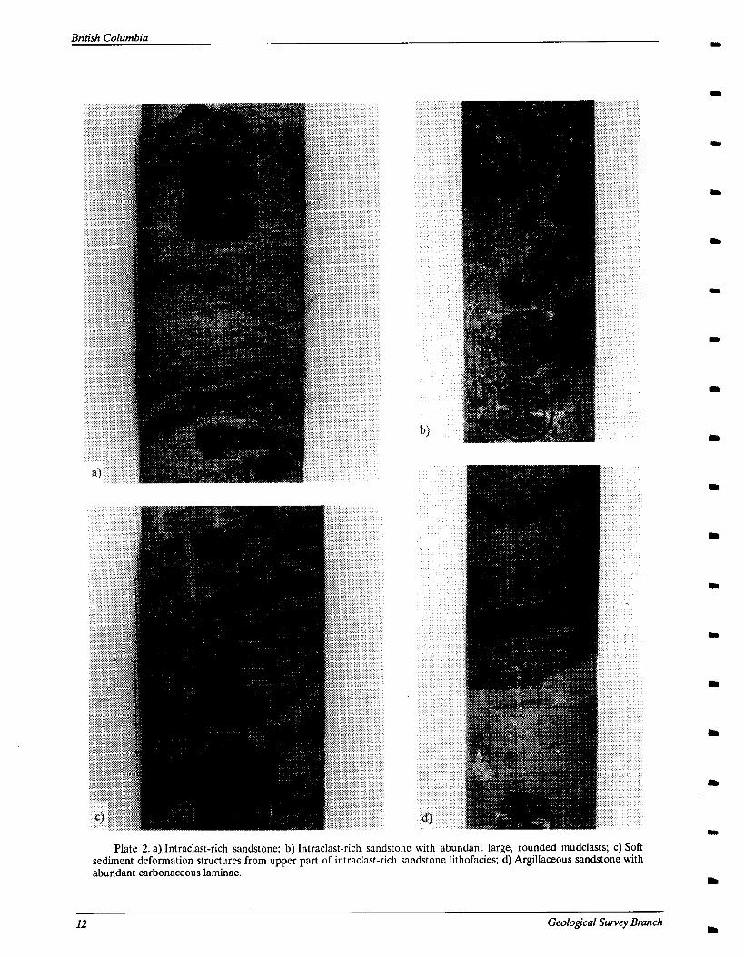
LITHOFACIES C: INTRACLAST-RICH SANDSTONE The distinguishing characteristics of this sandstone is
the presence of abundant rounded or angular mudstone
clasts, partially replaced by siderite or pyrite, which occur in a poorly sorted matrix of coal spar, mudstone, tine to medium-grained sandstone and granules (Plate 2a). Where mudstone clasts are most abundant, the lithofacies is a matrix-supported intraclast conglomerate (Plate 2b). Lithofacies C averages 3 metres in thickness with sharp upper and lower contacts, and locally, the lithofacies fines upward. Scour structures commonly occur. In the upper part of the lithofacies, sorting improves to moderate, carbonaceous laminae are abundant, and parallel bed- ding is well developed. Thin (1 centimetre) interbedded mudstone, typically distorted by soft-sediment deforma- tion occurs throughout the lithofacies (Plate 2~).
LITHOFACIES D: ARGILLACEOUS SANDSTONE The argillaceous sandstone lithofacies comprises
tine-grained sandstone up to 3 metres thick, with abun-
Paper 1991-2 11
British Columbia
Plate 2. a) Intraclast-rich sandstone; b) Intraclast-rich sandstone with abundant large, rounded mudclasts; C) Soft sediment deformation structures from upper part of intraclast-rich sandstone lithofacies; d) Argillaceous sandstone with abundant carbonaceous laminae.
12 Geological Survey Bmnch
Ministry of Energy, Mines and Petroleum Resounzes
dant carbonaceous laminae and millimetre to centimetre- scale carbonaceous mudstone beds (Plate 2d). Lower and upper contacts are sharp or gradational. The lithofacies may fine or coarsen upward. Small silt and sand filled scours are common. Soft sediment deformation struc- tures, mudcracks, and rootlets are occasionally present. Well preserved macroscopic plant fossils occur rarely.
LITHOFACIES E: CARBONACEOUS MUDSTONE Lithofacies E consists of medium to dark grey, thinly
laminated, carbonaceous, kaolinitic mudstone with thin coal stringers. It is up to 10 metres thick, and upper and lower contacts are gradational. Rootlets and well-pre- served plant fossils are usually present (Plate 3a), and the palynomorph content is dominated by miospores and gymnosperm pollen (Sweet, G.S.C. Report AS-90-01, Ap- pendix I). Scour horizons and centimetre-scale sandstone beds and scours are common. Pyrite occurs associated with organic debris, or as isolated blebs. Rarely, sand grains are scattered within the mudstone. Carbonaceous mudstone is interbedded with all other lithofacies.
Plate 3. a) Carbonaceous mudstonewithwell-pre- served plant fossils; b) Seatearth with pisolitic texture near top of sample and roots throughout.
LITHOFACIES F: COAL Coal in Unit I is dull, banded, or bright, and fre-
quently contains pyrite as blebs or in cleats. Individual seams are up to 6 metres thick, and coal zones (coal and partings) may exceed 12 metres in thickness. Partings are laterally extensive, thin, tabular, and fine grained. Rarely, partings are lenticular sandstone bodies. Coal is grada- tionally underlain by carbonaceous mudstone or fireclay, and is gradationally or sharply overlain by a variety of facies.
LITHOFACIES G: FIRECLAY
Fireclay consists of light pink-grey, very fine grained, kaolinitic mudstone up to 6 metres thick. It contains abundant, well preserved (occasionally pyritic) rootlets, large coal spar, and spherical orange siderite nodules (Plate 3b). Fractures are conchoidal and slickensided. This lithofacies may be up to 6 metres thick. The lower and upper contacts are gradational, and the upper con- tact is usually mottled. In some localities, the lowermost part of this lithofacies consists of up to 30 centimetres of dark grey carbonaceous mudstone with abundant red spherulitic siderite grains. Rarely, the uppermost part of the lithofacies has a pisolitic texture (Plate 3b). In out- crop, fireclay is very resistant. Fireclay may overlie any
Plate 4. Mottled claystone.
Paper 1991-2
British Columbia
lithofacies, and is usually overlain by carbonaceous mud- stone or coal.
LITHOFACIES I-k MOlTLED CLAYSTONE This lithofacies has a mottled appearance, and con-
sists of very fine-grained, reddish-purple and light green, kaolinitic mudstone with conchoidal and slickensided fracture surfaces (Plate 4). The thickness rarely exceeds 2 metres and lower and upper contacts are gradational. Rootlets are locally present, and reddish-coloured mot- tles contain abundant sub-millimetre siderite spherulites. Mottled claystone is interbedded with carbonaceous mudstone, and is only found in the lower third of Unit I. Locally, it directly overlies volcanic basement.
DEPOSITIONAL ENVIRONMENTS OF LITHOFACIES
Unit I comprises alluvial sediments derived from, and deposited on, the underlying irregular, eroded, deeply weathered volcanic land surface. Braided river and floodplain facies are recognized.
BRAIDED RIVER (LITHOFACIES A, B, C AND D) In the study area, braided river channel deposits are
represented by two facies associations. The most com- mon association is composed of cyclic, 0.5 to l.O-metre beds of conglomerate and massive sandstone. Poorly sorted conglomerates are channel lag deposits, and better sorted, clast-supported, imbricated conglomerate and massive sandstone represent longitudinal bars of braided river systems (Miall, 1977). Cross-bedded sandstone was deposited on the margins and downstream end of bars. Bar tops are represented by beds of rippled sandstone, mud drapes, desiccation cracks and roots. Random lithofacies patterns, such as are present in this lithofacies association, are produced in braided river systems where channels and bars shift rapidly and only fragmented bars and channel fills are preserved. A complex history of erosion and deposition are recorded in the preserved deposits.
A second lithofacies association is a vertical fining- upward sequence of conglomerate overlain by cross-bedded sandstone. This association is interpreted to be the deposits of a single channel. The presence of finer sediments at the top is indicative of waning flow.
Lithofacies C and D represent higher levels of the braid plain, which were active only during stages of high flood. During high stages, water and sediment spilled out of the main channels and spread over the floodplain. Coarse sediment and large mudclasts in lithofacies C were deposited as bedload in reactivated channels. The presence of fine sediment together with poorly sorted sand, granules, pebbles and mud clasts is indicative of rapid sedimentation. Finer, parallel bedded sandstone and mudstone were deposited during waning flow, and locally, bedding was convoluted during subsequent dewa-
tering. Thinly interbedded sandstone, mudstone, and car- bonaceous material in lithofacies D reflect repeated inundation of the floodplain by sediment-laden water. Periods of inactivity in the higher levels of the braid plain are represented by mudcracked and rooted horizons.
FLOODPLAIN (LITHOFACIES E, F, G, AND H) Carbonaceous mudstone and thii peat beds accumu-
lated as vertical accretion deposits in low energy floodbasins and backswamps away from active channels. Well-preserved plant fossils together with thinly lami- nated mudstone reflect slow deposition from suspension in low-energy conditions. The high kaolinite content of samples of the mudstone suggests that leaching occurred to some degree. Mudstone with interbedded sandstone and scattered sand grains represent parts of the flood- plain which were proximal to active channels and frequently received coarser sediment during overbank flooding and wind storms.
Kaolinitic, rooted fireclays are seatearths, and repre- sent leaching and soil development on portions of the floodplain characterized by decreased sediment supply and lower water table. Siderite nodules in seatearths precipitated from slightly reducing ground water in satu- rated soils (Reading, 1976; Leckie et al., 1989). The characteristic, slickensided fracture of seatearths in the study area developed as a result of collapse and compac- tion of roots (Huddle and Patterson, 1961) and peds (Leckie et al., 1989).
Mottled claystone also represents soil development, despite a paucity of carbonaceous matter other than oc- casional rootlets. The kaolinitic composition reflects leaching, and the mottled texture is indicative of poorly drained conditions with a high water table (Leckie et al., 1989). The rarity of carbonaceous matter may be attrib- utable to long-term exposure and oxidation of the organic-rich layer.
Seatearths in Unit I are commonly overlain by thick, laterally extensive coal seams. Peat formation reflects a change to more submerged conditions, in which preser- vation of a thick organic layer was favored. Thicker peat beds were preserved where peat accumulation kept pace with subsidence and water table rise. Laterally extensive, tabular mudstone splits in the coal seams represent peri- ods of increased subsidence and associated increase in terrigenous influx.
DEPOSITIONAL HISTORY OF UNIT I An alluvial environment persisted throughout the
deposition of Unit I. Deposition began with intense weathering and local soil development on the Jurassic volcanic land surface. With continued weathering of sur- rounding volcanic rocks, braided rivers spread pebbles, granules and coarse sand derived from the volcanics across the study area. Thick packages of coarse sediment
14 Geological Survey Branch
Ministry of Energy Mines and Petmleum Resounzes
accumulated in a topographic low in the northern part of and development of a poorly drained floodplain and the study area. Floodplains were developed in the inter- backswamp, probably as a result of denudation of the channel areas, but preservation of carbonaceous mud and source area and waning of sedime,nt supply without tec- peat was hampered because of frequent erosion by mi- tonic rejuvenation. A marine transgression halted grating channels. deposition of Unit I.
As the topography was levelled (by erosion of highs and deposition in lows), a peat-forming floodplain was established, resulting in the formation of coal zone 1 (Figure 11). Peat formation was interrupted by terrige- nous influx during periods of accelerated subsidence. Peat development was also disrupted by periods of de- creased subsidence and relative stability, leading to the formation of seatearths. Peat deposition climaxed with the formation of seams lB, lC, and lD, which are thick, laterally extensive seams. In the southern part of the study area, seam 1B is missing and seam 1C is very thin over a paleotopographic high on the underlying Jurassic volca- nic basement, suggesting that peat marshes over the high were better drained than in other areas (Figures 8 and 11). While peat deposition prevailed in the southwest, elastic deposition continued in the northeast. Coal seams tend to thin and split in a northeastward direction, and more of the partings are composed of sandstone, likely reflecting periodic flooding and erosion of peat close to channels.
UNIT II SEDIMENTOLOGY
GENERAL DESCRIPTION
Unit II comprises 110 to 140 metres of grey muddy siltstone interbedded with light grey-green beds of chert- rich, micaceous, bioturbated or cross-bedded sandstone. Details of the sandstone petrography of Unit II are pre- sented in Appendix III. The contact between Unit I and II is usually sharp, but is not defined by the presence of a particular marker bed; rather, it is denoted by the occur- rence of bioturbated sandstone or siltstone on top of essentially unbioturbated, fluvial deposits of Unit I. The uppermost strata of Unit II comprise a 10 to Smetre thick, regionally extensive coarsening-upward sequence, abruptly overlain by coal zone 1 of Unit III. The coarsen- ing-upward sequence consists of silty mudstone with an upward increasing abundance of planar, lenticular, and wavy bedded siltstone or tine-grained sandstone.
LITHOFACIES DESCRIPTIONS The overall fining-upward sequence observed in
Unit I (from predominantly coarse-grained deposits at the base to exclusively fine-grained sediments and coal at the top) reflects abandonment of the active braid plain
Five lithofacies are recognized in Unit II. Lithofacies A through E are scattered laterally and vertically throughout the unit, and lithofacies F is restricted to the
Figure 11. Depositional environment of the upper strata of Unit I. Peat formed in poorly drained backswamps in a fluvial environment. Clastic deposition continued in the northeastern part of the study area.
Paper 1991-2
western part of the study area. Lithofacies are difficult to correlate laterally, for facies changes are abrupt (as illustrated in Figure 12). Few drill holes penetrated thick sections of Unit II, so no single complete section was core logged.
LITHOFACIES A: SILTY MUDSTONE Lithofacies A is up to 30 metres thick and is com-
posed dominantly of light grey highly bioturbated silty mudstone. Contacts with underlying and overlying lithofacies are gradational or sharp. The massive, struc- tureless appearance of this lithofacies is a result of extensive biogenic reworking. The only readily identili- able trace fossil in the mudstone is Helminthopsis, which is abundant, especially in siltier layers (Plate 5a). Physical sedimentary structures are rare, consisting of 1 to 4 cen- timetre thick, wavy or graded beds of very fine-grained sandstone with occasional Plunolites burrows. Locally, 3-metre-thick beds of very fine-grained, bioturbated (Helminthopsis and rare Ophiomorpha?) sandstone occur interbedded in the silty mudstone (Plate 5b). Ma- rine fauna in lithofacies A consist of gastropods, inoceramid-like pelecypods, trigonids (Myophorella?), scaphopods (Dentalium?) and boring bivalves (Teredo)
(Smith, personal communication, 1990; Poulton, G.S.C. Report J-lo-1990-TPP, Appendix II; Plate 6a). A diverse population of dinoflagellates are present throughout and are locally abundant, whereas terrestrial spores and pol- len are rare to abundant (Sweet, G.S.C. Report AS-90-01, Appendix I). Siderite bands and concretions and pyritized coal spar are common, and carbonaceous lam- inations are rare.
Thin (less than 20 centimetres) limestone beds occur in silty mudstone near the top of Unit II. They comprise microscopic calcium carbonate concretions, partially re- placed by chert, in a muddy matrix (Plate 7). Contacts between adjacent concretions are polygonal.
LITHOFACIES B: INTERBEDDED SANDSTONE AND MUDSTONE
This lithofacies is characterized by moderately bioturbated, thinly interbedded light grey-green to green, fine to medium-grained sandstone and mudstone (Plate 6b). The thickness may exceed 15 metres. The lower contact is frequently sharp, and the upper contact is gradational or sharp. Generally, the lithofacies coarsens upward, and then abruptly fines to lithofacies A. Fine organic detritus and siderite concretions are abundant. Wavy and parallel bedding is present throughout, and
SW NE DH 348 DH 318 DH 361 DH 425 DH 354 DH 330
S
BnXsh Columbia
1.3 km 1.0 km 1.1 km 1.0 km
/ I / I-
-
5 datum: top of coal seam 1 D ;7
Figure 12. Stratigraphic cross-section through Unit II showing lithofacies distribution. Lithofacies A: silty mudstone. B: interbedded sandstone and mudstone. C: mottled argillaceous sandstone. D: carbonaceous mudstone. E: cross-bedded sandstone.
16 Geological Swvqy Bmnch
Ministry of Energv Mines and Petroleum Resomes
Plate 5. a). Silty mudstone with Helminthopsis trace fossils. Bedding defined by lighter-coloured, silt- ier layer; b) Very fine-grained sandstone and well-preserved Ophiomotpha(?) trace fossil in silty mudstone lithofacies.
massive sandstone is common in the upper part. Planar cross-beds, graded beds, scour structures and carbona- ceous laminations also occur. Bedding is frequently disrupted by Skolithos, Planolites, and Teichichnus trace fossils, especially near the base; and Macaronichnus is locally present in massive sandstone near the top of the lithofacies (Plate 8a).
LITHOFACIES C: MOTTLED ARGILLACEOUS SANDSTONE
This lithofacies is up to 4 metres thick and comprises poorly sorted, highly bioturbated fine to medium-grained argillaceous sandstone (Plate 8b). The sandstone usually has a gradational basal contact and a sharp upper contact. The ichnofossil content includes Rosselia?, and other poorly-defined, large, mud filled and sideritized burrows. Isolated pelecypod shells occur locally.
LITHOFACIES D: CARBONACEOUS MUDSTONE Dinoflagellate-bearing, carbonaceous mudstone, up
to 3 metres thick, with thin, root-mottled beds and coaly
Plate 6. a) Boring bivalves (Teredo) in fossilized wood from silty mudstone lighofacies; b) Interbedded sandstone and mudstone, with abundant Pkmolites trace fossils and a Skolithos trace fossil near bottom of photo.
Plate 7. Calcium carbonate concretions partially replaced by chert.
Paper 1991-2 I7
British Columbia
Plate 8. a) Macamnichnus trace fossils from upper part of interbedded sandstone and mudstone lithofacies; b) Heavily bioturbated, mottled argillaceous sandstone. Funnel shaped trace fossil near centre of photo is Rosselia; c) Cross-bedded sandstone.
intervals define this lithofacies (Sweet, G.S.C. Report AS-90-01, Appendix 1). Contacts with underlying and overlying lithofacies are gradational. Argillaceous coal seams less than a metre thick are rare. Carbonaceous mudstone is interbedded with all other lithofacies.
LITHOFACIES E: CROSS-BEDDED SANDSTONE
This lithofacies comprises up to 30 metres of cross- bedded, fine grained, light grey-green micaceous sandstone with occasional thin mudstone and carbona- ceous laminae (Plate 8~). The basal contact is sharp, whereas the upper contact is gradational. Convolute soft sediment deformation structures are abundant, and rip- ples and climbing ripples are common, particularly in the upper part of the lithofacies. Calcium carbonate concre- tions (up to 2 centimetres in diameter) occur throughout. Mudstone intraclasts and small pelecypod shells are rare. Bioturbation is minimal and restricted to a few Skolithos burrows. Cross-bedded sandstone is usually interbedded with silty mudstone and carbonaceous mudstone.
DEPOSITIONAL ENVIRONMENTS OF LITHOFACIES
Unit II was deposited in a deltaic environment. Intcr- distributary bay, coastal marsh, bay fill, and distributary channel facies are recognized.
INTERDISTRIBU’Il4RY BAY (LITHOFACIES A)
The fine grain size, abundance of bioturbation (espe- cially Helminthopsis), and presence of marine fauna and dinoflagellates in silty mudstone are characteristic of de- position in a quiet marine environment. The abundance of coal spar, terrestrial spores and pollen, and carbona- ceous laminations reflects a nearshore, quiet marine environment (Sweet, G.S.C. Report AS-W-01, Appendix I). Carbonaceous laminations in the silty mudstone formed as fine organic matter, carried into the bay by distributaries, settled out of suspension. Coarser grained wavy and graded beds are indicative of temporary higher energy conditions and are probably storm deposits, par- tially reworked by organisms. Thicker, bioturbated sandstone bodies probably do not represent single storm events, but reflect continuous sediment influx; during which time the sedimentation rate and energy conditions were low enough for habitation by burrowing organisms. They may be distal bay fill or distributary mouth bar deposits, but without knowing more about the geometry of the deposits, interpretation is difficult.
The coarsening-upward sequence observed in silty mudstone where it directly underlies marsh sediments of Unit III, was produced during progradation of the shore- line over bay sediments. The precipitation of calcium carbonate concretions in the progradational sequence may reflect production of hydrogen sulphide in the over-
18 Geological Survey Branch
Ministry of Energy, Mines and Petmieum Resounzes
lying marsh, raising the pH of interstitial water and low- flow, probably due to abandonment of splays and subsi- ering the solubility of calcium carbonate (Harding, 1988). dence of bay fill deposits.
COAS’IAL MARSH (LITHOFACIES D) The combined presence of dinoflagellates, root-mot-
tling and coal in this lithofacies reflects deposition in a brackish-water marsh. The close association of this lithofacies with bay deposits (silty mudstone) suggests that it formed in salt-marshes immediately surrounding bays.
Lithofacies C may represent abandoned, completely reworked baylill deposits. The relatively coarse grain size and limited lateral extent of the lithofacies, and its close association with bay deposits, are indicative of deposition in proximal bay fills; followed by complete destruction of sedimentary structures by burrowing.
DISTRIBUTARY CHANNEL (LITHOFACIES E)
BAY FILL (LITHOFACIES B AND C) Lithofacies B, interbedded sandstone and mudstone,
represents baylills formed during intermittent flooding from distributary channels. Coarsening-upward trends are produced from progradation of splays over previous deposits. The upward decrease in biogenic structures reflects increased energy conditions and/or sedimenta- tion rate associated with progradation. Massive sandstone present near the top of the lithofacies repre- sents maximum flow, under which conditions bioturbation was minimal and the preservation potential of burrows was small. Mucaronicltrtus, the only trace fossil present in the massive sandstone, is characteristic of very shallow marine, high energy, depositional environments (Ekdale et al., 1984). Thin fining-upward sequences usu- ally present at the top of the lithofacies reflect waning
The limited lateral extent, sharp basal contact, and fining-upward, cross-bedded character of this lithofacies is indicative of deposition in channels, and the close association of channel deposits with marine bay deposits (lithofacies A) suggests that the channel deposits repre- sent distributary channels. Bioturbated sandstone interbeds near the base of the lithofacies represent dis- tributary mouth bar deposits, over which channels prograded. Locally, highly convoluted beds formed dur- ing periods of rapid sedimentation. Upper, rippled parts of lithofacies E developed during waning flow, perhaps as distributaries were abandoned, and an abundance of organic debris and fine sediment at the top of the lithofac- ies reflects slow deposition from su.spension.
DEPOSITIONAL HISTORYOFUNITII Deposition of Unit II began during a marine trans-
gression which flooded alluvial coal-forming swamps of
Figure 13. Depositional environment of Unit II. Sandstone and mudstone accumulated in distributaries, bay-fills, and bays in a deltaic and shallow marine environment.
Paper 1991-2 19
DH 345 DH343
S DH 335
DH 322 i f DH321 / z
f i 2142m I I 714m i ) 571m 643m 571m i 357m -..l
sl~rf MUDSTONE STBATIFIED BIOTURBATED SCOUR HORIZON CARBONACEOUS LENTICUIAR
SANDSTONE SANDSTONE MUDSTONE SILTSTONE’MUDSTONE numbered)
_._ . ~- ~-
Figure 14. a) Cross-section through Unit III showing lithofacies distribution. Logs are gamma-ray and density. Cross-section passes twice through a zone of relatively minor coal formation, which represents a restricted nearshore marine depositional environment. Arrows drawn beside the lower portions of the gamma-ray logs show the coarsening-upward sequence immediately below Unit III. Location of cross-section shown in Figures 3 and 14b.
Unit II. A deltaic and nearshore marine environment was established, which prevailed in the study area throughout the deposition of Unit II.
Poor drill hole control makes paleogeographic inter- pretation of Unit II difficult, but some observations may be made. Bay and baylill deposits display seemingly ran- dom distribution patterns, both vertically and laterally. These patterns probably developed as a result of several factors, such as channel avulsion, variable sedimentation rate, and changes in coastline morphology. The geometry of the delta is unknown. Deposition of Unit II halted with a regression, coastal progradation, and re-establishment of a coastal plain in the study area. A general sketch of the depositional environment in which Unit II was depos- ited is illustrated in Figure 13.
UNIT III SEDIMENTOLOGY
GENERAL DESCRIPTION Unit III averages about 90 metres thick and includes
the sediments between the base of coal zone 2 and the
343 . . .
. r -b- l .
. . . . . RESTRICTED
309 345
/
322 ;z:,“,“““’ l . l ENVIRONMENT
. . ,*
. 0 321
- - - -~-- _
. . . .
. . . 335
. . .
ii NoDATA y . 1 6052330m N
Figure 14. b) Location of cross-section in Figure 14a, relative to location of restricted nearshore marine environment which persisted throughout deposition of Unit III.
20 Geological Survey Branch Ir
Ministry of Enemy, Mines and Petroleum Resomes m
a
(I
a
I
m
base of a laterally extensive green massive siltstone or line sandstone bed which is the basal member of Unit IV In the western part of the study area, Unit III comprises a diverse sequence of chert-rich, micaceous sandstone, silt- stone, mudstone and nine coal zones (Appendix III). In the east, it contains two coal zones near the base overlain by silty mudstone. Coal zones average 2 to 4 metres thick, and thin and split eastward.
LITHOFACIES DESCRIPTIONS Seven lithofacies are recognized in Unit III. Lithofac-
ies A to F occur regularly throughout the stratigraphic sequence, and lithofacies 1G occurs at only one locality. A detailed depiction of the lithofacies distribution is shown in Figures 14a and 14b.
LITHOFACIES A: SILTY MUDSTONE
Structureless, medium grey, micaceous silty mud- stone similar to that present in Unit II constitutes the vast majority of this lithofacies. The thickness ranges up to 50 metres. The lower contact is gradational with carbona- ceous mudstone or lenticular bedded mudstone and sandstone, and the upper contact with Unit IV is sharp. Much of the silty mudstone is mottled by bioturbation, and Hehninthopsis trace fossils are common. Coal spar, isolated pelecypods, and sideritic bands and concretions commonly occur. Locally, 1 to 5 centimetre siltstone or fine sandstone beds are present; these are usually highly bioturbated (Planolites, rare Resselia, and other indistinct traces), but they may be normally graded or wavy-bedded and contain marine pelecypod shell lags. Scours filled with coarse sand and biogenic escape structures occur infrequently. Rarely, massive quartzose sandstone beds up to a metre thick, with sharp upper and lower contacts, occur within the muddy siltstone. The base of this lithofacies contains few terrestrial palynomorphs and an abundance of a single species of dinoflagellate (Gonyaulucysta orthoceras (Eisenack) Sarjeant 1966), and the upper part of the lithofacies contains relatively fewer dinoflagellates and more terrestrial spores, pollen, and fusinite debris (Sweet, G.S.C. Report AS-90-01, Ap- pendix I).
LITHOFACIES B: STRATIFIED SANDSTONE
This lithofacies comprises light grey-green, mica- ceous, moderately sorted, horizontally laminated fine-grained sandstone with subrounded grains. The thickness ranges up to 10 metres. The basal contact is usually sharp and erosional, whereas the upper contact is gradational. The sandstone contains numerous thin bur- rowed (Plunolites) mudstone beds. Convolute beds, load casts, planar cross-bedding, and wavy or flaser bedding are commonly developed (Plate 9). Scours filled with coarse or granular sandstone, mudclasts, and biogenic escape structures occur locally. Skolithos and CyZ-
indrichnus trace fossils occur sporadically, and rare rooted mudstone beds are present.
LITHOFACIES c: BIOTURBATED SANDSTONE
This lithofacies consists of bioturbated, light grey- green, micaceous, fine-grained sandstone with subrounded grains, and minor mudstone. It is character- ized by a predominance of biogenic over sedimentary structures, and it fines upward. The thickness ranges up to 30 metres, but bioturbated sandstone frequently occurs as 1 to 10 centimetre beds within other facies. The lower contact is usually gradational with stratified sandstone, and the upper contact is gradational or sharp. 7’eichichnus trace fossils are abundant, ZoophJws locally occurs, and Skolithos is present in isolated wavy beds (Plates 10a and lob). Rarely, marine pelecypod hashes and thin-shelled gastropod coquinas are present (I’. Smith, personal com- munication; Appendix II). Carbonaceous beds and laminae occur sporadically throughout, and scours filled with coarse or granular sandstone, mudclasts and bio- genie escape structures occur locally.
Plate 9. Wavy-bedded sandstone from the strati- fied sandstone lithofacies.
Paper 1991-2 21
British Columbia
Plate 10. a) Eichichnus trace fossil in bioturbated sandstone; b) Zoophyws trace fossil in bioturbated sandstone; C) Syneresis cracks in lenticular-bedded siltstone and mudstone.
22 Geological Survey Bnwch
Ministry of Energy, Mines and Petroleum Resouxes
LITHOFACIES D: CARBONACEOUS MUDSTONE This lithofacies is composed of up to 6 metres of dark
grey, locally planar-laminated, root-mottled, carbona- ceous mudstone with thin coal stringers. Upper and lower contacts are gradational or sharp. Rootlets and pyrite blebs are present locally. Carbonaceous mudstone con- tains an abundance of terrestrial spores, pollen, and fusinite, as well as some dinoflagellates; but less organic- rich mudstones contain an abundant, low-diversity assemblage of dinoflagellates and relatively little terres- trial organic matter (Sweet, G.S.C. Report AS-90-01, Appendix I).
LITHOFACIES E: LENTICULAR BEDDED SILTSTONE AND MUDSTONE
Regularly spaced, thin (1 to 2 millimetres) lenticular beds of light to medium grey siltstone in carbonaceous mudstone impart a characteristic banded appearance to this lithofacies (Plate 10~). Beds of lenticular siltstone and mudstone can exceed 6 metres in thickness, but thinner beds, less than 10 centimetres thick, occur within carbo- naceous mudstone or bioturbated sandstone. Upper and lower contacts are gradational. The siltstone:mudstone ratio is variable but averages 5050. Load casts, syneresis cracks, and well-preserved plant fossils are abundant, and crenulated algal mats are occasionally present (Plates lOc, lla, llb, and 12). Parallel bedding is common, and sand and shell-filled scours occur rarely. Both dinoflag- ellates and terrestrial organic matter are abundant (Sweet, G.S.C. Report AS-90-01, Appendix I).
LITHOFACIES F: COAL
Coal seams in Unit III are thick and laterally exten- sive, and are split by carbonaceous mudstone or lenticular bedded siltstone and mudstone. Individual seams are up to 6 metres thick, and average 2 to 3 metres. The coal contains a predominance of banded lithotypes, and fusain lenses are locally abundant. Pyrite blebs with diameters of 1 to 10 millimetres are common.
LITHOFACIES G: MASSIVE SANDSTONE
This lithofacies was found at only one locality, a 3-metre outcrop section near drillhole 326. Massive fine- grained sandstone, with rare lenticular siltstone and mudstone beds, occurs as an isolated body that sharply truncates lenticular bedded siltstone and mudstone, car- bonaceous mudstone, and coal. A block of banded coal is enclosed within the sandstone. The top and base of the sandstone body were not observed.
DEPOSITIONAL ENVIRONMENTS OF LITHOFACIES
Paralic conditions prevailed throughout the deposi- tion of Unit III. Restricted nearshore marine, intertidal flat/storm, upper intertidal flat, tidal channel, and coastal swamp facies occur in the study area.
Plate 11. a) Well-preserved cycad fossil in lenticu- lar-bedded siltstone and mudstone; b) Algal mats in lenticular bedded siltstone and mudstone.
Plate 12. Photomicrograph of algal mats.
Paper 1991-2 23
British Columbia
RESTRICI’ED NEARSHORE MARINE (LITHOFACIES A) The abundance but low diversity of dinoflagellates in
silty mudstone suggests that it was deposited in a quiet, restricted marine environment. Structureless mudstone such as is prevalent in lithofacies A is common in quiet, nearshore marine deposits and results from complete bioturbation. Helminthopsis, a deposit-feeder trace-fossil which occurs in lithofacies A, is often representative of deep marine environments, but it can also occur in re- stricted nearshore marine environments, which are similarly quiet and nutrient-rich (Ekdale et al., 1984). Sporadic thin wavy-bedded sandstone beds in lithofacies A are a product of periodic wave agitation, perhaps during storms. Locally, these sandstone beds were re- worked by burrowing organisms. Massive sharp-based sandstones interbedded in the silty mudstone may repre- sent washover deposits, but a paucity of sedimentary structures (perhaps due to biogenic reworking) makes interpretation of these sandstone bodies difficult.
INTERl’IDAL FLAT (LITHOFACIES B AND C)
Lithofacies B and C closely resemble modern tidal flat sediments such as those described by (Weimer, 1982). Lithofacies B formed on a sand flat (seaward intertidal flat), and lithofacies C formed on a mud flat (landward intertidal flat). In the study area, vertical transitions be- tween sand and mud flat facies are common. Each transition represents a change in energy level and sedi- mentation rate associatedwith tidal flat progradation and retreat.
Interlaminated sandstone, siltstone and mudstone exhibiting horizontal stratification and wavy and flasar bedding found in the sand flat facies (lithofacies B) were produced by weak tidal currents and waves. These struc- tures formed in an environment with constantly fluctuating but low-energy conditions. Brief periods of sand and coarse silt deposition by tidal currents and waves alternated with fine sediment deposition from sus- pension. The paucity of biogenic relative to physical sedimentary structures in the sand flat facies is largely a result of current and wave processes, which actively re- worked the sandflat and inhibited preservation of biogenic structures. Only vertically burrowing suspension feeders, such as Skolithos, are present in lithofacies B, suggesting that the sand flat was a stressful biological niche because of the shifting substrate and high sedimen- tation rate.
The mud flat (lithofacies C), being higher on the tidal flat than the sand flat, was subject to a lower sedimenta- tion rate and less wave and current reworking. Therefore, this environment was more conducive to habitation by burrowing organisms (especially for feeding structures such as Teichichnus, a common trace-fossil in lithofacies C) and later preservation of their burrows (Ekdale et al., 1984). However, the low diversity of the ichnofossil as-
semblage reflects the harsh environmental conditions (fluctuating energy and salinity) that characterized the tidal flat.
Lithofacies B and C contain a number of scoured horizons, reflecting temporarily increased energy condi- tions, such as exist during storms. At least one laterally extensive, correlatable scour horizon is present in the study area, representing a single event during which a blanket of debris (sand and shells, and mud clasts) was deposited on the intertidal flat. Escape structures were created by organisms which rapidly burrowed upwards in attempts to keep pace with the accelerated sedimentation rate. Once coarse material was introduced, it remained, as normal energy conditions were too low to transport it out again.
UPPER INTERTIDAL FLAT (LITHOFACIES D AND E) Lithofacies D and E were deposited in the upper
intertidal flat. The presence of a low-diversity assemblage of dinoflagellates associated with roots and coal stringers (lithofacies D) is indicative of a vegetated, restricted, brackish water depositional environment such as a salt marsh, which forms above daily tide levels on upper intertidal flats. Thinly laminated carbonaceous mudstone reflects slow deposition of fine-grained sediment and organic detritus under low energy conditions high on the tidal flat.
Frequently flooded areas of the upper intertidal flat are represented by thinly bedded (planar and lenticular) tine sandstone and dinoflagellate-bearing, carbonaceous mudstone (lithofacies E). Mudcracks, lenticular bedding, and syneresis cracks in lithofacies E reflect periodic dessication and fluctuating energy and salinity levels, and the paucity of bioturbation is indicative of harsh ecologi- cal conditions. Locally, algal mats colonized portions of the upper intertidal flat.
COASTAL SWAMP (LITHOFACIES F) Halophilicvegetation was established in salt marshes
on the upper intertidal flat, evident from the presence of rooted beds and thin coaly layers in dinoflagellate-bear- ing carbonaceous mudstone. Salt marsh peat does not produce thick coril seams, and, at best, forms thin lenses of high-ash, high-sulphur coal (Cohen, 1984). Salt marshes have a near neutral pH which encourages deg- radation of the peat (Renton and Cecil, 1979). In addition, salt marshes accumulate clay during floods and storms, which results in high-ash peat.
Thick, laterally extensive coal seams of the nine major coal zones in Unit III probably formed from fresh- water peat swamps. The swamps were probably located landward of the tidal flat, more isolated from influxes of brackish water. The abundance of sulphur in most of the coal seams (see ‘Sulphur Content’) suggests that the peat was infiltrated periodically by sulphate-rich (probably marine) water. This may have occurred during temporary
I
m
m
m
I
24 Geological Survey Branch
a
I
m
(I
a
I
Ministry of Energy, Mines and Petroleum Resomes
flooding of the freshwater swamp with brackish water, or (as described by Staub and Cohen, 1979) is a reasonable during transgression of a brackish water environment modern analog for the paleoenvironment in which Unit over the marsh. Thus, the major coal seams are interpre- III was deposited. Examples of other coalfields associ- ted to have formed from peat accumulated in a freshwater ated with tidal flat sediments are found in the Wdcox marsh that was proximal to, but usually isolated from a Group of Texas (Breyer and McCabe, 1986), the Rock brackish environment. Splits in the coal are thin, tabular, Springs Formation of Wyoming and Utah (Roehler, and laterally extensive, suggesting that they formed dur- 1986), and the Beckley coal of West Virginia (Horne et ing regional, increased subsidence in the study area. al., 1978).
TIDAL CHANNEL (LITHOFACIES C)
At one locality, a channel was cut through marsh and upper intertidal flat sediments. During the incision pro- cess, peat mat was dislodged and incorporated into the channel sandstone. This channel is assumed to be tidal in origin because of its association with tidal sediments. In addition, the presence of lenticular bedding is indicative of fluctuating energy, typical of tidal channels.
DEPOSITIONAL HISTORY OF UNIT III
During deposition of most of Unit III, tidal flat and coastal swamp environments prevailed in the western part of the study area, and a restricted nearshore marine environment persisted in the east, suggesting that locally, the paleoshoreline trended north-south with the land- ward side to the west (Figures 14a, b, and 18). Tidal flats and peat-forming coastal swamps were probably situated well back from an active coastline (‘type 2’ environment of Cohen, 1984; Figure 15), explaining the development of thick, laterally extensive coal seams.
The coarsening-upward sequence directly underly- ing Unit III is a regressive sequence marking a transition between offshore/shoreface marine sediments and non- marine carbonaceous mudstone and coal. The absence of sediments characteristic of foreshore or beach environ- ments suggests the marine sediments were prograded over by a lower energy nearshore environment such as a lagoon or bay, and eventually by a coastal swamp, at which time deposition of Unit III began. Restricted nearshore marine, tidal flat and coastal swamp environments per- sisted throughout deposition of Unit III. Dinoflagellates occur throughout Unit III, even in samples taken from directly above and below coal seams, which indicates that there was significant marine influence during deposition of the entire unit. The Snuggedy Swamp of South Carolina
Major episodes of coal formation were initiated and halted by regression and progradation of the tidal flat, which in turn was a function of c.hanges in coastal mor- phology, sediment supply, or sea Ilevel. As a result, the ten coal zones in Unit III are separated by tidal flat sediments (Figures 14a and 14b). The depositional strike of coal zones in Unit III is north-south, parallel to the postulated local paleoshoreline. Thick coal zones tend to overlie thick sandstone bodies (Figure 17). Presumably, thick sandstone bodies compacted least and became topo- graphic highs, which may have been more conducive to peat accumulation because they offered protection from flooding by brackish water. Eastward, coal seams thin, split, and, in the case of coal zones 4 to 10, pinch out into restricted nearshore marine sediments (Figure 16). Splits in these seams are a result of general subsidence and
TYPE III (OKEFENOKEE SWAMP, GA.) TYPE II TYPF T
(SNUGGEDY SWAMP, S.C.) (N&S;<A FRESH WATER MODERN SHORELINE)
S W;t;;;;l;A$SH UPPER ESTUARINE, BRACKISH-FRESH
LAGOONAL SALT MARSH
q BEACH-BARRIER
ORtHOQUAAftlTlC SANDS
&yj SALT MARSH CLAYS
(ROOTED) FRESH WATER PEAT
Figure 15. Shoreline related peat-forming environments. From Cohen (1984). Unit III was deposited in a “type II” environment.
Paper 1991-2 25
Brzlish Columbia
COAL ZONES 2 AND 3 COAL ZONES 4 AND 5 COAL ZONE 6 COAL ZONE 7
COAL ZONE 8 COAL ZONE 9 COAL ZONE 10
Figure 16. Distribution of coal zones in Unit III, showing eastern depositional limits of each zone. Coal represented by shaded areas. Area represented by maps shown in Figure 2.
6055330m N
.
.
THICKNESS OF SANDSTONE DIRECTLY BELOW
COAL ZONES FOUR AND FIVE
:
THICKNESS IN METRES: THICKNESS IN MEI-RES:
THICKNESS OF COAL ZONES FOUR AND FIVE
4 5-10 lo-12 12-15 15-20 >20 <l 1-2 2-3 3-4 >4 Figure 17. Isopach maps of coal zones 4 and 5 (combined), and of the sandstone immediately underlying the coal
zones. Thickness in metres. Boxed area represents same area shown as the ‘Goathom Region’ in Figure 2.
26 Geological Survey Brunch
I
&
m
I
Figure 18. Depositional environment of Unit III. Restricted nearshore marine, tidal flat, tidal channel, and coastal marsh environments existed.
extensive flooding of the peat swamp. Clastic influx from other sources (for instance, from tidal channels and splays) was insignificant in the study area, as lenticular ‘washout’ splits are rare. Tidal channels, which are an important element in modern tidal flats, are poorly rep- resented in the study area. Drillhole and outcrop spacing within the study area may be too large to recognize them.
A marine transgresson ended deposition of Unit III. During transgression, the upper part of Unit III was partially eroded; as a result, the upper coal zones (8, 9, and 10) are locally missing and are directly overlain by unit IV
UNIT IV SEDIMENTOLOGY
GENERAL DESCRIPTION Unit IV abruptly overlies Unit III and consists of a
laterally extensive, bright green, chert-rich, chloritic sandstone or siltstone bed at the base, overlain by massive grey silty mudstone similar to that of Unit II. The petrog- raphy of the basal sandstone is described in detail in Appendix III. Koo (1983) reports a thickness of 150 metres for Unit IV; only the basal 40 metres were core logged in this study. Quaternary sediments unconform- ably overlie Unit IV, and in most of the study area, the majority or all of Unit IV has been eroded.
LITHOFACIES DESCRIPTIONS; The basal 40 metres of Unit IV comprise two lithofac-
ies; green sandstone and silty mudstone. The sandstone petrography of the basal sandstone is presented in Ap- pendix III. Handy and Cameron (3.984) and Koo (1983) examined longer sections of Unit IV and report the pres- ence of additional lithologies.
LITHOFACIES A: GREEN SANDSTONE Lithofacies A consists of bright green, chloritic, mas-
sive line-grained sandstone or siltstone. It is 1 to 5 metres thick, and always sharply overlies Unit III. The upper contact is gradational with grey muddy siltstone (lithofac- ies B). The sandstone is regionally correlatable across the study area. Generally, the sandstone appears massive, but in places, it appears mottled by bioturbation. Coal spar, fine organic detritus, and large, poorly defined, pyritic, sand-filled burrows are common. Mudstone rip-up clasts are locally present.
LITHOFACIES B: SILTY MUDSTONE This lithofacies comprises structureless (completely
bioturbated) silty mudstone with rare 1 to 5 centimetre thick parallel beds of slightly bioturbated (Plunolites?) siltstone or fine sandstone. Helminthopsis trace fossils are abundant, and are particularly apparent in siltier zones. Siderite bands and concretions, pyritized coal spar, and
Paper 1991-2 27
British Columbia
carbonaceous matter commonly occur. Silty mudstone contains rare to common dinoflagellates, and a relatively high abundance of terrestrial spores, pollen, and fusinite (Sweet, G.S.C. Report AS-90-01, Appendix I). This lithofacies is very similar to silty mudstone in Unit II.
DEPOSITIONAL ENVIRONMENTS OF LITHOFACIES
Unit IV was deposited in a marine environment. Following transgression and deposition of a lag sandstone on top of the sediments of Unit III, a quiet water nearshore marine environment prevailed.
TRANSGRESSIVE LAG (LITHOFACIES A; GREEN SANDSTONE)
The sheet-like geometry and erosive basal contact of the green sandstone lithofacies are typical characteristics of transgressive lag deposits. During a marine transgres- sion, sediments of Unit III were eroded, reworked, and redeposited over the old coastal plain. The presence of marine silty mudstone (lithofacies B) overlying the sand- stone is consistent with a marine transgression.
The abundance of chlorite in Unit IV may reflect the change from a terrestrial to a paralic/marine depositional environment. Chlorite is commonly concentrated in la- goonal and nearshore environments where iron-bearing rivers enter the sea, and mixed-layer montmorillonite/il- lite converts to chlorite (Folk, 1974). Additional chlorite may also have been produced during weathering of the uppermost sediments of Unit III, for chlorite can be
formed from weathering of other clay minerals in soils (Curtis, 1984).
QUIET NEARSHORE MARINE (LITHOFACIES B; SILTY MUDSTONE)
Silty mudstone in Unit IV is interpreted to have been deposited in a quiet, nearshore marine environment be- cause of several facts: the combined presence of dinoflagellates and abundant terrestrial spores, pollen, and fusinite, the presence of quiet-water marine ichnofossils, and the fine-grained, completely bioturbated texture of the lithofacies. In Unit IV, delta facies, such as distributary channels, were not recognized, so it is uncertain if silty mudstone in Unit IV was depos- ited in an interdistributary bay or in another type of low-energy coastal environment.
DEPOSITIONAL HISTORY OF UNIT IV Unit IV was deposited during a marine transgression.
During transgression, the uppermost sediments of Unit III were winnowed and reworked by shallow marine wave, current, and tide processes and redeposited as a sheet sandstone. A quiet, nearshore marine environment be- came established. Deposition in this environment was primarily from suspension, but coarser sediment was pe- riodically transported in during storms.
Coal seams and dinoflagellate-barren sediments are present in the upper Unit IV (Handy and Cameron, 1984; Koo, 1983), indicating that terrestrial conditions resumed later in the depositional history of Unit IV
2% Geological Survey Brunch
Ministry of Energy, Mines and Petmleum Resources
STRATIGRAPHY AND SEDIMENTOLOGY OF THE NORTH TELKWA REGION OF
THE TELKWA COALFIELD
Eight cores from the North Telkwa region were ex- II and IV were penetrated by drillholes in the western part amined, facilitating a comparison of the stratigraphy and of the study area, and Unit I and thin sections of Unit II sedimentology of the North Telkwa and Goathorn re- were encountered in a few holes d.rilled into uplifted fault gions. blocks on the eastern perimeter (Figure 19).
STRATIGRAPHY The lithostratigraphy of the Lower Skeena Group in
the North Telkwa region is very similar to that described for the Goathorn region. In the North Telkwa region, the strata overlie volcanic basement and are divisible into the same four units. Unit III and incomplete sections of Units
Three marker beds present in the Goathorn region are also present in the North Telkwa region: the gamma- ray spike in coal zone 1 of Unit I, the coarsening-upward sequence at the top of Unit II, and the green sandstone at the base of Unit IV.
Lithofacies present in the Goathorn region also occur in the North Telkwa region. The distribution of the
NW SE DH 811 DH 804 DH 805 DH814DH440 DH504 DH218 DH443 DH444
L 340m - - 500m / - 340m - ‘150m A m 1040m * ‘208m 2 L 306m -’ -382m -
7 CORES NOT LOGGED
6U 6L
LITHOFACIES LEGEND:
3E 4A 2A 3A 3D 3G 40
UNIT I
Figure 19. Cross-section of the North Telkwa region of the Telkwa coalfield showing lithdfacies distribution. Lithofacies abbreviations same as in text; first digit of abbreviation refers to unit number. Geophysical logs are gamma-ray and density. Coal zones of Unit III and coal seams of Unit I are labelled. Location of cross-section shown in Figure 3.
1D 1c
1AB
Papw1991-2 29
British Columbia
lithofacies is similar, with some exceptions in Unit III. Silty mudstone, an important lithofacies in the eastern part of Unit III in the Goathorn region, does not occur in the North Telkwa region (Figures 14a, 14b, and 19). In addition, sandy lithofacies are much less prevalent in the North Telkwa region than in the Goathorn region. In the Goathorn region, Unit III contains two major sandstone beds (above coal zones 3 and 7) and several thinner sandstone beds, whereas in the North Telkwa region, only one thick sandstone bed is present, above coal zones 6 and/or 7 (Figures 14a, 14b, and 19). Consequently, Unit III is thinner in the North Telkwa region, with a maximum thickness of approximately 70 metres as compared to an average of 90 metres in the Goathorn region. In the North Telkwa region, Unit III thickens northwestward, due to the presence of a thick elastic wedge between coal zones 5 and 6 in the western part of the region (Figure 19).
Coal zones in the North Telkwa region are correlat- able with those in the Goathorn region, and the same nomenclature can be used, although seams in the North Telkwa region tend to thicken, thin, split, or pinch out over short distances (Figure 19). The thicknesses of individual seams average 1 to 3 metres, comparable to seam thick-
nesses recorded in the Goathorn region. Coal zones in the North Telkwa region, particularly coal zone 5, thicken southeastward, and interburden thins. A zone of no coal development, such as is present in the eastern part of the Goathorn region, does not occur in the North Telkwa region. In the North Telkwa region, two additional thick seams are present below coal zone 1 (Figure 19). These may be correlative to a thin, discontinuous, argillaceous coal seam present at approximately the same strati- graphic horizon in the Goathorn region (Figure 8).
DEPOSITIONAL ENVIRONMENTS The depositional environments that prevailed during
deposition of the Lower Skeena Group in the Telkwa coalfield were very similar in the Goathorn and North Telkwa regions, although some minor differences existed. Peat deposition in Unit I of the North Telkwa region began earlier than in the Goathorn region, resulting in the development of thick seams below coal zone 1. In Unit III of the North Telkwa region, lagoons did not develop, and sandflats and mudflats were not established until after the deposition of coal zone 6. Deposition occurred primarily in upper intertidal flats and coastal marshes.
30 Geological Survey Bmnch
m
m
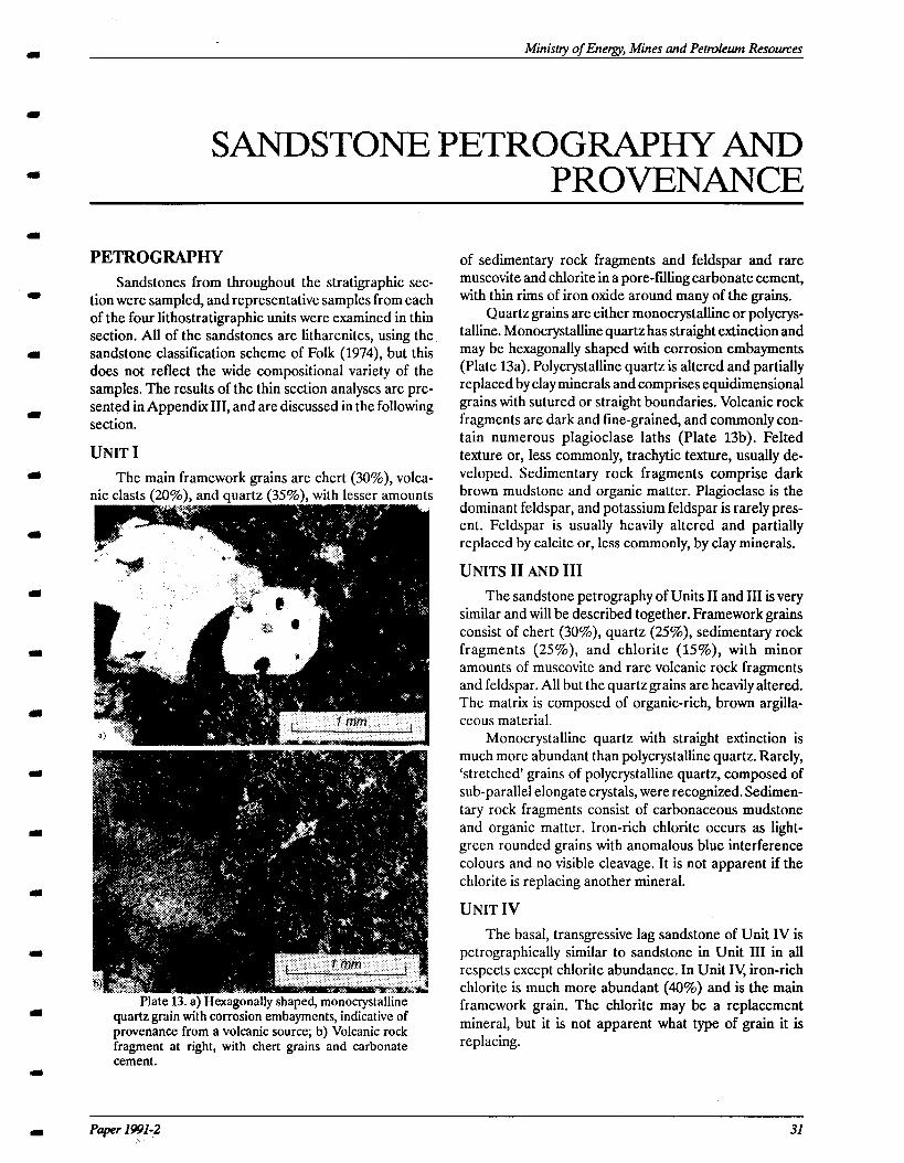
Ministy of Energy, Mines and Petroleum Resomes
SANDSTONEPETROGRAPl3YAND PROVENANCE
a
PETROGRAPHY Sandstones from throughout the stratigraphic sec-
tion were sampled, and representative samples from each of the four lithostratigraphic units were examined in thin section. All of the sandstones are litharenites, using the sandstone classification scheme of Folk (1974), but this does not reflect the wide compositional variety of the samples. The results of the thin section analyses are pre- sented in Appendix III, and are discussed in the following section.
UNIT I The main framework grains are chert (30%), volca-
nic clasts (20%). and auartz (35%). with lesser amounts
ate 13. a) Hexagonally shaped, monocrystalline quartz grain with corrosion embaymcnts, indicative of provenance from a volcanic source; b) Volcanic rock fragment at right, with chert grains and carbonate cement.
of sedimentary rock fragments and feldspar and rare muscovite and chlorite in a pore-filling carbonate cement, with thin rims of iron oxide around many of the grains.
Quartz grains are either monocrystalline or polycrys- talline. Monocrystalline quartz has straight extinction and may be hexagonally shaped with corrosion embayments (Plate 13a). Polycrystalline quartz is altered and partially replaced by clay minerals and comprises equidimensional grains with sutured or straight boundaries. Volcanic rock fragments are dark and fine-grained, and commonly con- tain numerous plagioclase laths (Plate 13b). Felted texture or, less commonly, trachytic texture, usually de- veloped. Sedimentary rock fragments comprise dark brown mudstone and organic matt’er. Plagioclase is the dominant feldspar, and potassium feldspar is rarely pres- ent. Feldspar is usually heavily altered and partially replaced by calcite or, less commonly, by clay minerals.
UNITS II AND III The sandstone petrography of Units II and III is very
similar and will be described together. Framework grains consist of chert @I%), quartz (25%), sedimentary rock fragments (25%), and chlorite (15%), with minor amounts of muscovite and rare volcanic rock fragments and feldspar. All but the quartzgrains are heavily altered. The matrix is composed of organic-rich, brown argilla- ceous material.
Monocrystalline quartz with straight extinction is much more abundant than polycrystalline quartz. Rarely, ‘stretched’ grains of polycrystalline quartz, composed of sub-parallel elongate crystals, were recognized. Sedimen- tary rock fragments consist of carbonaceous mudstone and organic matter. Iron-rich chlorite occurs as light- green rounded grains with anomalous blue interference colours and no visible cleavage. It is not apparent if the chlorite is replacing another mineral.
UNIT IV The basal, transgressive lag sandstone of Unit IV is
petrographically similar to sandstone in Unit III in all respects except chlorite abundance. In Unit IV, iron-rich chlorite is much more abundant (40%) and is the main framework grain. The chlorite may be a replacement mineral, but it is not apparent what type of grain it is replacing.
Paper 1991-2 31
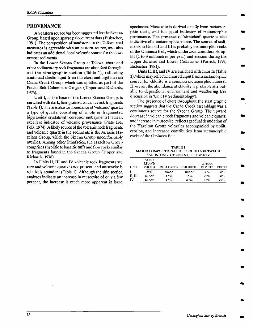
British Columbia
PROVENANCE An eastern source has been suggested for the Skeena
Group, based upon sparse paleocurrent data (Eisbacher, 1981). The composition of sandstone in the Telkwa coal measures is agreeable with an eastern source, and also indicates an additional, local volcanic source for the low- ermost sediments.
In the Lower Skeena Group at Telkwa, chert and other sedimentary rock fragments are abundant through- out the stratigraphic section (Table l), reflecting continued elastic input from the chert and argillite-rich Cache Creek Group, which was uplifted as part of the Pm&i Belt-Columbian Orogen (Tipper and Richards, 1976).
Unit I, at the base of the Lower Skeena Group, is enriched with dark, fine-grained volcanic rock fragments (Table 1). There is also an abundance of ‘volcanic’ quartz, a type of quartz consisting of whole or fragmented bipyramidal crystals with corrosion embayments that is an excellent indicator of volcanic provenance (Plate 13a; Folk, 1974). A likely source of the volcanic rock fragments and volcanic quartz in the sediments is the Jurassic Ha- zelton Group, which the Skeena Group unconformably overlies. Among other lithofacies, the Hazelton Group comprises rhyolitic to basaltic tuffs and flow rocks similar to fragments found in the Skeena Group (Tipper and Richards, 1976).
In Units II, III and IV volcanic rock fragments are rare and volcanic quartz is not present, and muscovite is relatively abundant (Table 1). Although the thin section analyses indicate an increase in muscovite of only a few percent, the increase is much more apparent in hand
specimens. Muscovite is derived chiefly from metamor- phic rocks, and is a good indicator of metamorphic provenance. The presence of ‘stretched’ quartz is also indicative of a metamorphic source. The source of sedi- ments in Units II and III is probably metamorphic rocks of the Omineca Belt, which underwent considerable up- lift (1 to 3 millimetres per year) and erosion during the Upper Jurassic and Lower Cretaceous (Parrish, 1979; Eisbacher, 1981).
Units II, III, and IV are enriched with chlorite (Table l), which may reflect increased input from a metamorphic source, for chlorite is a common metamorphic mineral. However, the abundance of chlorite is probably attribut- able to depositional environment and weathering (see discussion in ‘Unit IV Sedimentology’).
The presence of chert throughout the stratigraphic section suggests that the Cache Creek assemblage was a continuous source for the Skeena Group. The upward decrease in volcanic rock fragments and volcanic quartz, and increase in muscovite, reflects gradual denudation of the Hazelton Group volcanics accompanied by uplift, erosion, and increased contribution from metamorphic rocks of the Omineca Belt.
TABLE 1 MAJOR COMPOSITIONAL DIFFERENCES BEIWEEN
SANDSTONES OF UNITS I, II, III AND IV
VOLC RF AND OTHER
UNIT VOLC Q MUSCOVITE CHLORITE QUARTZ CHERT
I 25% minor minor 30% 30% II, III minor <S% 15% 2.5% 30% IV minor cS% 40% lS% 25%
32 Geological Swvey Branch
m Ministry of Energy, Mines and Petroleum Resomes
REGIONAL SIGNIFICANCE OF THE TELKWA COAL MEASURES
Strata in the Telkwa coallield are correlatable with other nearby Cretaceous coal measures at Denys Creek, Thautil River, Chisholm Lake, and Zymoetz River (Koo, 1984). The Telkwa coal measures are also correlatable with coal-bearing ‘Red Rose Formation’ sediments west of the study area in the Roche Deboule Range; members A, B, and C of the Red Rose Formation, as described by Sutherland Brown (1960) (Figure 5), are very similar to Units I, II, and III of the Telkwa coal measures.
It has been proposed that the Telkwa coal measures are correlative with the upper strata of the Groundhog coalfield (Currier Formation) north of the Skeena Arch in the Bowser Basin (Koo, 1984; Richards and Gilchrist, 1979). However, the Currier Formation is wholly Jurassic in age (Cookenboo and Bustin, 1989), whereas theTelkwa coal measures are middle Cretaceous. The Telkwa coal measures are more similar (lithologically, mineralogi- tally, and in terms of age and depositional environment) to the coal-bearing Aptian/Albian McEvoy Formation in the Bowser basin, one of two formations considered equivalent to the Skeena Group by Cookenboo and Bustin (1989). Cretaceous ‘Skeena Group’ sediments have also been described south of the Skeena arch in the Nechako Basin (Tipper and Richards, 1976; Kleinspehn, 1985; Hunt and Bustin, 1990). Apparently, deposition of the Skeena Group occurred in a different basin, termed the ‘Nazco Basin’ by Hunt and Bustin (1990), than the Jurassic Bowser Lake Group, for Jurassic sediments were not deposited across the Skeena arch (Tipper and Rich- ards, 1976).
Subsidence of the study area, accompanied by uplift and erosion of source areas, led to accumulation of Alb- ian Lower Skeena Group sediments on middle Jurassic Hazelton Group volcanics in the Telkwa coalfield. Sedi- ments of the Skeena Group record two transgressive events. The transition from Unit I to Unit II marks an abrupt change from a braided fluvial system to a del- taic/near-shore environment, and the transition from Unit III to Unit IV reflects a change from a paralic (coastal plain/tidal flat) environment to a near-shore ma- rine setting.
Chert and other sedimentary rock fragments are abundant throughout the Lower Skeena Group in the study area. This reflects continued elastic influx from the eastern Cache Creek Group, which was uplifted as part of the Pinchi belt-Columbian orogen (Tipper and Rich-
ards, 1976). The basal strata are relatively enriched with texturally and mineralogically immature coarse-grained sediment, with a large proportion of volcanic grains and ‘volcanic’ quartz, indicative of derivation from local vol- canic rocks of the Hazelton Group. The lining-upward trend in Unit I, from conglomerate and sandstone to mudstone and coal, represents a transition to a lower-en- ergy depositional environment, resulting from gradual denudation of the source area. The paucity of volcanic material in Units II, III, and IV, and relative abundance of muscovite, reflects decreased elastic influx from the Hazelton Group and increased influx from a metamor- phic source. High-grade metamorphic rocks of the Omineca Belt, east of the study area, were likely the source of muscovite, for the Omineca Belt was undergo- ing rapid uplift in the middle Cretaceous as a result of the collision between Stikinia (composite terrane I) and the North American craton in the Middle Jurassic (Parrish, - 1979; Eisbacher, 1981; Monger et al., 1984).
Strata in the study area are disrupted by northwest and northeast striking high-angle reverse faults. North- west striking faults may be related to regional compression which began in the middle Cretaceous, as a result of accretion of composite terrane II to North Amer- ica and subsequent uplift of the Coast plutonic belt (Eisbacher, 1981; Monger et al., 1984). Northeast striking faults in the study area may be related to emplacement of the Late Cretaceous ‘Bulkley Intrusions’ (quartz monzo- nite and granodiorite plutons) in the Telkwa area (Figure 1); similarly, east and northeast trending folds are com- mon in the southern Bowser basin, where numerous granitoid stocks were emplaced during the Late Creta- ceous (Woodsworth, 1979; Eisbacher, 1981). The presence of a high angle reverse fault, which cuts only the lowermost strata (Unit I) of the Telkwa coal measures, indicates that deformation also occurred in the Albian, and that an unconformity must be present in Unit II. Albian faulting may be related to subsidence and base- ment faulting of the Skeena arch; if this is the case, basement-controlled subsidence may have been respon- sible for at least the earliest transgressive event recorded in the stratigraphic section. A possible location for the unconformity would be at the base of the transgressive marine sediments of Unit II. Howeever, the unconformity was not directly observed, and an appreciable age differ- ence between Units I and III cannot be confirmed with palynological data (Appendix I).
Paper 1591-2 33

British Columbia
34 Geological Survey Bmnch
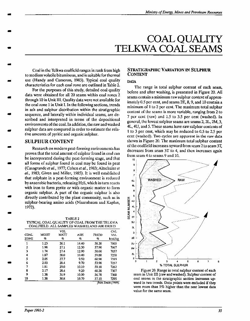
Ministry of Energy, Mines and Petrvleum Resouxes CL
a
m
COAL QUALITY TELKWA COAL SEAMS
Coal in the Telkwa coalfield ranges in rank from high to medium volatile bituminous, and is suitable for thermal use (Handy and Cameron, 1983). ‘@pical coal quality characteristics for each coal zone are outlined in Table 2.
For the purposes of this study, detailed coal quality data were obtained for all 20 seams within coal zones 2 through 10 in Unit III. Quality data were not available for the coal zone 1 in Unit I. In the following sections, trends in ash and sulphur distribution within the stratigraphic sequence, and laterally within individual seams, are de- scribed and interpreted in terms of the depositional environments of the coal. In addition, the raw and washed sulphur data are compared in order to estimate the rela- tive amounts of pyritic and organic sulphur.
SULPHUR CONTENT Research on modern peat-forming environments has
proven that the total amount of sulphur found in coal can be incorporated during the peat-forming stage, and that all forms of sulphur found in coal may be found in peat (Casagrande et aZ., 1977; Cohen ef al., 1983; Altschuler ef al., 1983; Given and Miller, 1985). It is well established that sulphate in a peat-forming environment is reduced by anaerobic bacteria, releasing H2S, which in turn reacts with iron to form pyrite or with organic matter to form organic sulphur. A part of the organic sulphur is also directly contributed by the plant community, such as in sulphur-bearing amino acids (Nissenbaum and Kaplan, 1972).
TABLE 2 TYPICAL COAL QUALITY OF COAL FROM THE TELKWA
COALFIELD. ALL SAMPLES WASHED.AND AIR DRIED
COAL MOM- ZONE %
1 1.23 2 1.98 3 1.74 4 1.87 5 2.05 6 2.03 7 1.81 8 2.17 9 1.38
VOL MA-l-r
%
26.1 27.1 27.4 28.0 27.7 28.4 29.0 28.4 31.9
ASH %
14.40 12.30 12.90 10.40
9.50 9.70
10.10 9.20
10.00
58.20 57.90 58.00 59.80 60.90 53.90 59.10 60.20 56.70
Paper 1991-2 35
FIXED 94
CAL VAL
kcal/kg
7005 7007 7057 72% 7319 7257 7262 7307 7368
10 1.38 30.8 10.70 57.10 7295 from Smi>h (1989).
STRATIGRAPHICVARIATIONINSULPHUR CONTENT DAVE4
The range in total sulphur content of each seam, before and after washing, is presented in Figure 20. All seams contain a minimum raw sulphur content of approx- imately 0.5 per cent, and seams 2E, 8,9, and 10 contain a minimum of 1 to 2 per cent. The maximum total sulphur content of the seams is more variable, ranging from 2 to 7 per cent (raw) and 1.5 to 3.5 per cent (washed). In general, the lowest sulphur seams are seams 2,2L, 2M, 3, 4L, 4U, and 5. These seams have raw sulphur contents of 1 to 3 per cent, which may be reduced to 0.5 to 2.5 per cent (washed). ?kro cycles are apparent in the raw data shown in Figure 20. The maximum total sulphur content of the coalfield increases upward from seam 2 to seam 3T, decreases from seam 3T to 4, and then increases again from seam 4 to seams 9 and 10.
0 1 2 3 4 5 6 7 6
% TOTAL SULPHUR
Figure 20. Range in total sulphur content of each seam in Unit III (raw and washed). Sulphur content of coal seams in the stratigraphic section increases up- ward in hvo trends. Data points were excluded if they were more than 5% higher than the next lowest data value for the same seam.
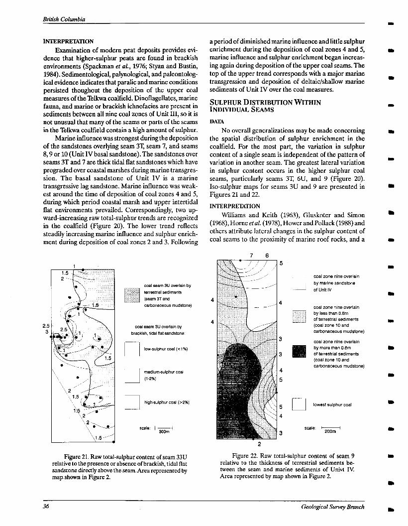
INTERP-ON Examination of modern peat deposits provides evi-
dence that higher-sulphur peats are found in brackish environments (Spa&man et aZ., 1976; Styan and Bustin, 1984). Sedimentological, palynological, and paleontolog- ical evidence indicates that paralic and marine conditions persisted thoughout the deposition of the upper coal measures of the Telkwa coalfield. Dinoflagellates, marine fauna, and marine or brackish ichnofacies are present in sediments between all nine coal zones of Unit III, so it is not unusual that many of the seams or parts of the seams in the Telkwa coalfield contain a high amount of sulphur.
Marine influence was strongest during the deposition of the sandstones overlying seam 3T, seam 7, and seams 8,9 or 10 (Unit IV basal sandstone). The sandstones over seams 3T and 7 are thick tidal flat sandstones which have prograded over coastal marshes during marine transgres- sion. The basal sandstone of Unit IV is a marine transgressive lag sandstone. Marine influence was weak- est around the time of deposition of coal zones 4 and 5, during which period coastal marsh and upper intertidal flat environments prevailed. Correspondingly, two up- ward-increasing raw total-sulphur trends are recognized in the coalfield (Figure 20). The lower trend reflects steadily increasing marine influence and sulphur enrich- ment during deposition of coal zones 2 and 3. Following
coal seam 3U overlain by terrestrial sediments
(seam 3T and carbonaceous mudstonel
coal seam 3U overlain by brackish, tidal flat sandstone:
low-sulphur coal (C 1%)
L. medium-sulphur coal (1.2%)
El high-sulphur coal (>2%)
scale: I&
Fire 21. Raw total-suiphur content of seam 33U Figure 22. Raw total-sulphur content of seam 9 relative to the presence or absence of brackish, tidal flat relative to the thickness of terrestrial sediments be sandstone directly above the seam. Area represented by tween the seam and marine sediments of Univt IV. map shown in Figure 2. Area represented by map shown in Figure 2.
a period of diminished marine influence and little sulphur enrichment during the deposition of coal zones 4 and 5, marine influence and sulphur enrichment began increas- ing again during deposition of the upper coal seams. The top of the upper trend corresponds with a major marine transgression and deposition of deltaic/shallow marine sediments of Unit IV over the coal measures.
SULPHUR DISTRIBUTION WITHIN 1NDM~uti SEms
DATA No overall generalizations may be made concerning
the spatial distribution of sulphur enrichment in the coalfield. For the most part, the variation in sulphur content of a single seam is independent of the pattern of variation in another seam. The greatest lateral variation in sulphur content occurs in the higher sulphur coal seams, particularly seams 3T, 6U, and 9 (Figure 20). Iso-sulphur maps for seams 3U and 9 are presented in Figures 21 and 22.
INTERPREIXTION Williams and Keith (1963), Gluskoter and Simon
(1968), Horne etal. (1978), Hower and Pollack (1988) and others attribute lateral changes in the sulphur content of coal seams to the proximity of marine roof rocks, and a
7 6
/
coal zone nine overlain by marine sandstone
of Unit IV
coal zone nine overlain by less than OBm of terrestrial sediments (coal zone 10 and carbonaceous mudstone)
coal zone nine overlain by more than 0.8m of terrestrial sediments
- (coal zone 10 and carbonaceous
lowest sulphur
,^^I^. 1 Sra.. 3 200m
coal
36 Geological Swvey Brunch
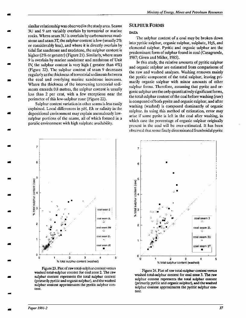
Ministry of Energy, Mines and Petroleum Resowces
similar relationship was observed in the study area. Seams 3U and 9 are variably overlain by terrestrial or marine rocks. Where seam 3U is overlain by carbonaceous mud- stone and seam 3T, the sulphur content is low (usually 2% or considerably less), and where it is directly overlain by tidal flat sandstone and mudstone, the sulphur content is higher (2% or greater) (Figure 21). Similarly, where seam 9 is overlain by marine sandstone and mudstone of Unit IV, the sulphur content is very high ( greater than 4%) (Figure 22). The sulphur content of seam 9 decreases regularly as the thickness of terrestrial sediments between the coal and overlying marine sandstone increases. Where the thickness of the intervening terrestrial sedi- ments exceeds 0.8 metres, the sulphur content is usually less than 2 per cent, with a few exceptions near the perimeter of this low-sulphur zone (Figure 22).
Sulphur content variation in other seams is less easily explained. Local differences in pH, Eh or salinity in the depositional environment may explain anomalously low- sulphur portions of the seams, all of which formed in a paralic environment with high sulphate availability.
SULPHURFORMS DATA
The sulphur content of a coal may be broken down into pyritic sulphur, organic sulphur, sulphate, H2S, and elemental sulphur. Pyritic and organic sulphur are the predominant form of sulphur found in coal (Casagrande, 1987; Given and Miller, 1985).
In this study, the relative amounts of pyritic sulphur and organic sulphur are estimated from comparisons of the raw and washed analyses. Washing removes mainly the pyritic component of the total sulphur, leaving pri- marily organic sulphur with minor amounts of other sulphur forms. Therefore, assuming that pyrite and or- ganic sulphur are the only quantitatively significant forms, the total sulphur content of the coal before washing (raw) is composed of both pyrite and organic sulphur, and after washing (washed) is composed dominantly of organic sulphur. In using this method of estimation, error may arise if some pyrite is left in the coal after washing, in which case the percentage of organic sulphur originally present in the coal will be over-estimated. It has been observed that some finely disseminated framboidal pyrite
F
coal seam 2E
.
I I I I
u 1 2 3 4 5 % total sulphur content (washed)
Figure 23. Plot of raw total-sulphur content versus washed total-sulphur content for coal zone 2. The raw sulphur content represents the total sulphur content (primarilypyritic and organic sulphur), and the washed sulphur content approximates the pyritic sulphur con- tent.
.
.
.
0.
. * A* Orn
coal seam 3 n
coal seam 3L 0
coal seam 3U *
coal seam 3T n
1
I I I I I
0 1 2 3 4 5 % total sulphur content (washed)
Figure 24. Plot of raw total-sulphur content versus washed total-sulphur content for coal zone 3. The raw sulphur content represents the total sulphur content (primarily pyritic and organic sulphur), and the washed sulphur content approximates the pyritic sulphur con- tent.
Paper 1991-2 37
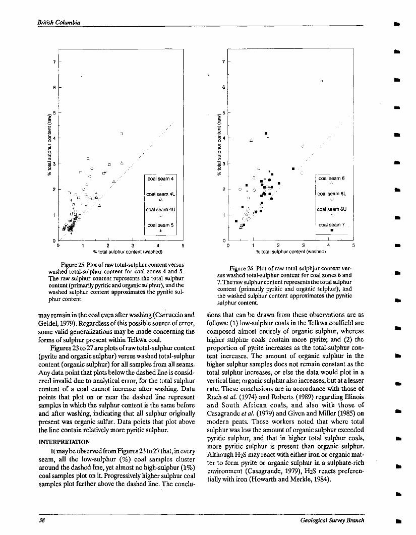
,
coal seam 4 0
coal seam 4L n
x3al seam 4U 0
coal seam 5 *
0 I,’ ’ I I I
0 1 2 3 4 % total sulphur content (washed)
Figure 25. Plot of raw total-sulphur content versus washed total-sulphur content for coal zones 4 and 5. The raw sulphur content represents the total sulphur content (primarily pyritic and organic sulphur), and the washed sulphur content approximates the pyritic sul- phur content.
may remain in the coal even after washing (Cakuccio and Geidel, 1979). Regardless of this possible source of error, some valid generalizations may be made concerning the forms of sulphur present within Telkwa coal.
Figures 23 to27 are plots of raw total-sulphur content (pyrite and organic sulphur) versus washed total-sulphur content (organic sulphur) for all samples from all seams. Any data point that plots below the dashed line is consid- ered invalid due to analytical error, for the total sulphur content of a coal cannot increase after washing. Data points that plot on or near the dashed line represent samples in which the sulphur content is the same before and after washing, indicating that all sulphur originally present was organic sulfur. Data points that plot above the line contain relatively more pyritic sulphur.
INTERPRETATION It may be observed from Figures 23 to 27 that, in every
seam, all the low-sulphur (%) coal samples cluster around the dashed line, yet almost no high-sulphur (1%) coal samples plot on it. Progressively higher sulphur coal samples plot further above the dashed line. The conclu-
*
.
A * 0
r coal seam 6 2
coal seam 6L ii
zeal seam 6U *
coal seam 7 .
~__
0 1 2 3 4 5 % total sulphur content (washed)
Figure 26. Plot of raw total-sulphjur content ver- sus washed total-sulphur content for coal zones 6 and 7.The raw sulphur content represents the total sulphur content (primarily pyritic and organic sulphur), and the washed sulphur content approximates the pyritic sulphur content.
sions that can be drawn from these observations are as follows: (1) low-sulphur coals in the Telkwa coalfield are composed almost entirely of organic sulphur, whereas higher sulphur coals contain more pyrite; and (2) the proportion of pyrite increases as the total-sulphur con- tent increases. The amount of organic sulphur in the higher sulphur samples does not remain constant as the total sulphur increases, or else the data would plot in a vertical line; organic sulphur also increases, but at a lesser rate. These conclusions are in accordance with those of Ruth er al. (1974) and Roberts (1989) regarding Illinois and South African coals, and also with those of Casagrande et al. (1979) and Given and Miller (1985) on modern peats. These workers noted that where total sulphur was low the amount of organic sulphur exceeded pyritic sulphur, and that in higher total sulphur coals, more pyritic sulphur is present than organic sulphur. Although H2S may react with either iron or organic mat- ter to form pyrite or organic sulphur in a sulphate-rich environment (Casagrande, 1979), H2S reacts preferen- tially with iron (Howarth and Merkle, 1984).
38 Geological Survey Bmnch
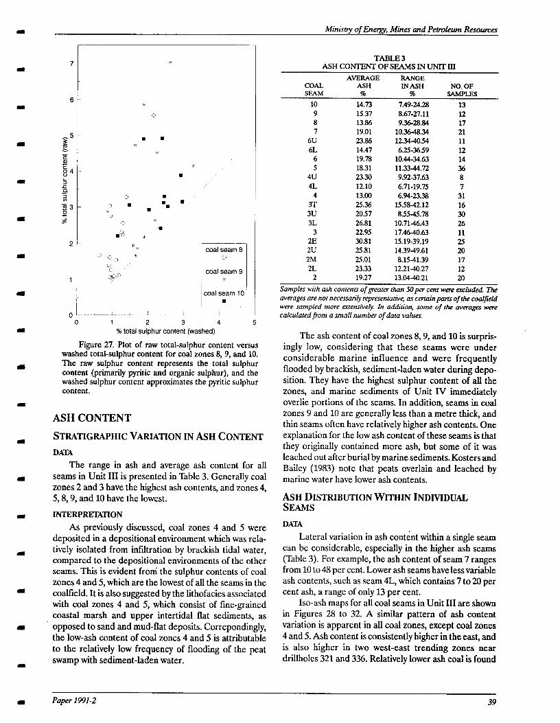
Ministry of Energy, Mines and Pettvleum Resounzes
*
*
0
. . *
* *
.
1
coal seam 9 0
coal seam 9 *
:oal seam 10 .
- ~ 1
0 1 2 3 4 5 % total sulphur content (washed)
Figure 27. Plot of raw total-sulphur content versus washed total-sulphur content for coal zones 8, 9, and 10. The raw sulphur content represents the total sulphur content (primarily pyritic and organic sulphur), and the washed sulphur content approximates the pyritic sulphur content.
ASH CONTENT
STRATIGRAPHIC VARIATION IN ASH CONTENT
DA’IA The range in ash and average ash content for all
seams in Unit III is presented in Table 3. Generally coal zones 2 and 3 have the highest ash contents, and zones 4, 5,8,9, and 10 have the lowest.
INTERPRETATION As previously discussed, coal zones 4 and 5 were
deposited in a depositional environment which was rela- tively isolated from infiltration by brackish tidal water, compared to the depositional environments of the other seams. This is evident from’ the sulphur contents of coal zones 4 and 5, which are the lowest of all the seams in the coalfield. It is also suggested by the lithofacies associated with coal zones 4 and 5, which consist of fine-grained coastal marsh and upper intertidal flat sediments, as opposed to sand and mud-flat deposits. Correpondingly, the low-ash content of coal zones 4 and 5 is attributable to the relatively low frequency of flooding of the peat swamp with sediment-laden water.
TABLE 3 ASH CONTENT OF SEAMS IN UNlT III
AVERAGE RANGE COAL ASH IN ASH NO. OF SEAM 7% % SAMPLES
10 14.73 7.49-24.28 13 9 15.37 8.67-27.11 12 8 13.86 9.36-28.84 17 7 19.01 10.364834 21
6U 23.86 12.34-4054 11 6L 14.47 6.25-3659 12
6 19.78 10.44-34.63 14 5 18.31 11.33-44.72 36
4u 23.30 9.92-37.63 8 4L 12.10 6.71-19.75 7
4 13.00 6.94-23.38 31 3T 2.5.36 15.58-42.12 16
3u 20.57 8.55-45.78 30 3L 26.81 10.71-46.43 26
3 22.95 17.46-40.63 11 2E 30.81 15.19-39.19 25
2u 25.81 14.3949.61 20 2M 25.01 8.1541.39 17 2L 23.33 12.21-40.27 12
2 19.27 13.0440.21 20
Samples with ash contents of greater than SOper cent were excluded. The averages are not necessan’ly representative, as certain parts of the co&field were sampled more azensivety. In addition, some of rhe averages were calculated from a small number of data values.
The ash content of coal zones 8,, 9, and 10 is surpris- ingly low, considering that these seams were under considerable marine influence and were frequently flooded by brackish, sediment-laden water during depo- sition. They have the highest sulphur content of all the zones, and marine sediments of Unit IV immediately overlie portions of the seams. In addition, seams in coal zones 9 and 10 are generally less than a metre thick, and thin seams often have relatively higher ash contents. One explanation for the low ash content of these seams is that they originally contained more ash, but some of it was leached out after burial by marine sediments. Kosters and Bailey (1983) note that peats overl.ain and leached by marine water have lower ash contents.
ASH DISTRIBUTION WITHIN INDMDUAL SEAMS
DATA Lateral variation in ash content within a single seam
can be considerable, especially in the higher ash seams (Table 3). For example, the ash content of seam 7 ranges from 10 to 48 per cent. Lower ash seams have less variable ash contents, such as seam 4L, which contains 7 to 20 per cent ash, a range of only 13 per cent.
Iso-ash maps for all coal seams in Unit III are shown in Figures 28 to 32. A similar pattern of ash content variation is apparent in all coal zones, except coal u>nes 4 and 5. Ash content is consistently higher in the east, and is also higher in two west-east trending zones near drillholes 321 and 336. Relatively lower ash coal is found
Paper 1991-2 39
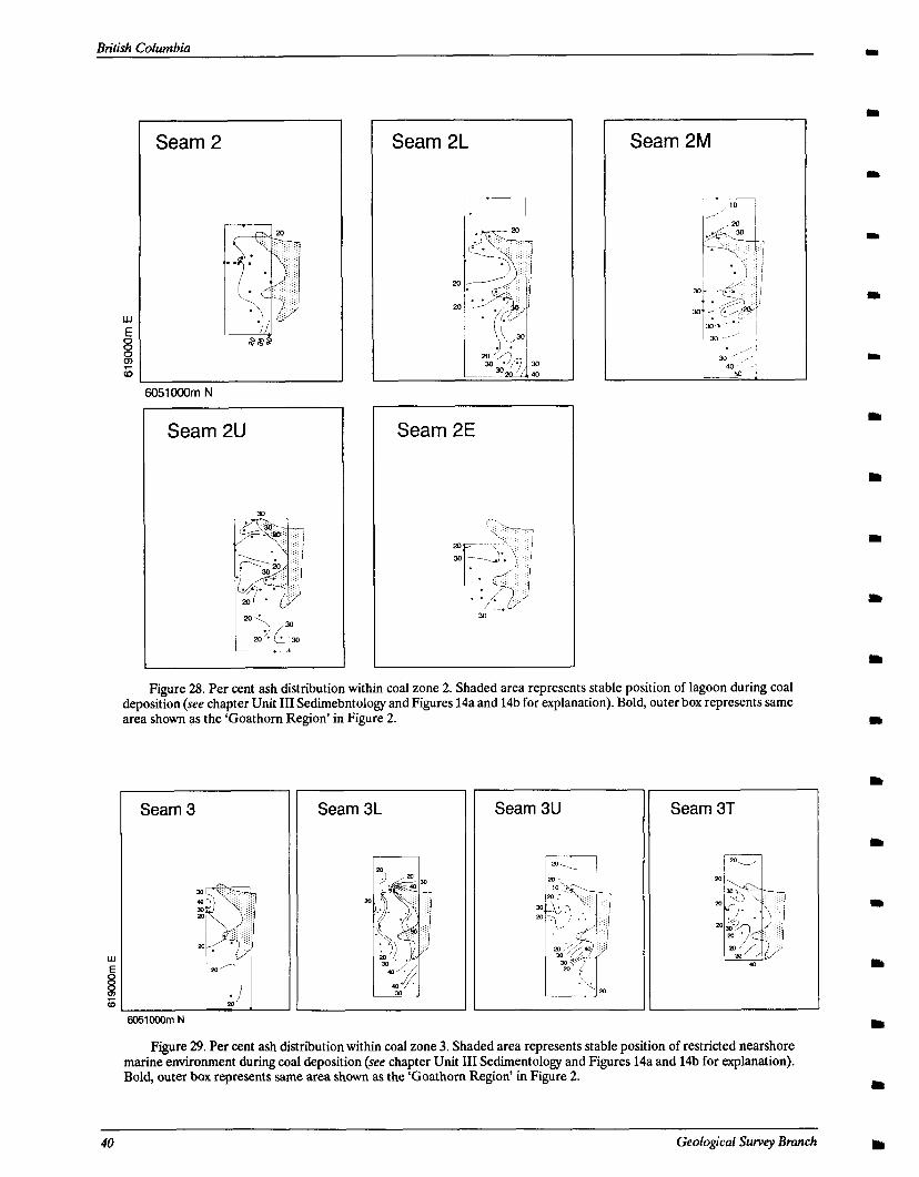
British Columbia
Seam 2
6051OOOm N
Seam 2L
Seam 2E
Seam 2M
Figure 28. Per cent ash distribution within coal zone 2. Shaded area represents stable position of lagoon during coal deposition (see chapter Unit III Sedimebntology and Figures 14a and 14b for explanation). Bold, outer box represents same area shown as the ‘Goathom Region’ in Figure 2.
Seam 3
w E
8 6
6051OCOm N
Seam 3L Seam 3U Seam 3T
Figure 29. Per cent ash distribution within coal zone 3. Shaded area represents stable position of restricted nearshore marine environment during coal deposition (see chapter Unit III Sedimentology and Figures 14a and 14b for explanation). Bold, outer box represents same area shown as the ‘Goathom Region’ in Figure 2.
40 Geological Survey Bmnch
a
1L
I
m
I
I
m
ml
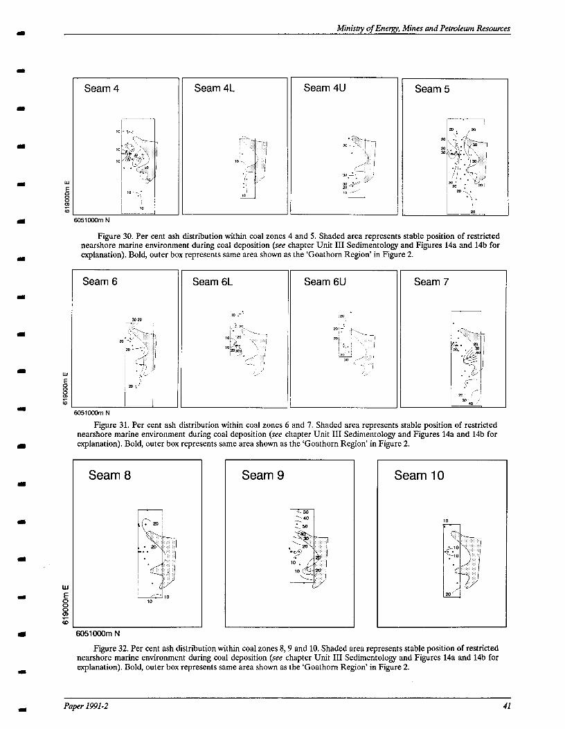
Ministry of Energy, Mines and Petroleum Resomes
Seam 4U Seam 4 Seam 4L
w E
8 8 6
6051COOm N
Figure 30. Per cent ash distribution within coal zones 4 and 5. Shaded area represents stable position of restricted nearshore marine environment during coal deposition (see chapter Unit III Sedimentology and Fi,gures 14a and 14b for explanation). Bold, outer box represents same area shown as the ‘Goathom Region’ in Figure 2.
Seam 6L Seam 7 Seam 6
6051OCOm N
Figure 31. Per cent ash distribution within coal zones 6 and 7. Shaded area represents stable position of restricted nearshore marine environment during coal deposition (see chapter Unit III Sedimentology and Figures 14a and 14b for explanation). Bold, outer box represents same area shown as the ‘Goathorn Region’ in Figure 2.
Seam 8 Seam 9 Seam 10
.20
.
. 20 ‘: . .
~
. . .’
.’ ‘..
.
10 10
I
m
W
(I E 8 8 zii
t 5051000m N a Figure 32. Per cent ash distribution within coal zones 8,9 and 10. Shaded area represents stable position of restricted
nearshore marine environment during coal deposition (see chapter Unit III Sedimentology and Figures 14a and 14b for explanation). Bold, outer box represents same area shown as the ‘Goathom Region’ in Figure 2.
I
Paper 1991-2
in the northern part -of the study area, near driiole 343, and in the central part of the study area near drillhole 320, between the two high ash zones.
INTERF’RElXTION Coal zones 4 through 10 pinch out generally eastward
into restricted, nearshore marine sediments. They also pinch out north and south into two west trending inlets of the nearshore marine environment, near drillholes 321 and 336 (Figures 14a and 14b). It is not surprising that coal that formed nearer to the margin of the nearshore marine environment (in the east and near drillholes 321 and 336) contains more ash, assuming that the ash is primarily detrital in origin. The margins of the peat swamp nearest the marine environment must have been frequently flooded with sediment-laden brackish water. Major floods would create partings, but sediment from minor floods would be incorporated into the peat.
The position of the restricted, nearshore environ- ment was very stable throughout deposition of coal zones 4 through 10, for nearshore marine siltstone is consis- tently present above coal zone 3 in drillholes 321,336, and
340. Correspondingly, the pattern of ash content distribu- tion varies little through the stratigraphic section. It is interesting to note that even coal zones 2 and 3 show the same pattern of variation, despite the fact that a marine environment was not present within the study area during the deposition of the seams in these zones. The concen- tration of ash in the east and near drillholes 321 and 336 suggests that these areas were local depocentres during deposition of coal zones 2 and 3. Perhaps these areas of the peat swamp were topographically lower and more susceptible to flooding and eventual invasion by a nearshore marine environment.
Coal zones 4 and 5 do not have the same pattern of ash distribution; for they are low ash/low sulphur seams that were under less marine influence during deposition despite being proximal to a nearshore marine environ- ment. Flooding from the marine environment played a less important role during deposition of coal zones 4 and 5, so there is no consistent pattern of ash enrichment for these coal seams.
42 Geological Suvey Branch
m
m
m
I The Lower Skeena Group in the Telkwa coalfield
comprises more than 500 metres of conglomerate, sand- stone, siltstone, mudstone and coal deposited during two regressive/transgressive cycles. The strata is Albian or
m possibly Aptian or Barremian in age, based upon palyno- logical and paleontological data. There is structural evidence for the presence of an unconformity within the
I stratigraphic section, for the lowermost strata are offset by as much as SO metres by a high-angle fault which did not disturb younger strata. An age difference between the lower and upper strata could not be confirmed.
I In the study area, the Lower Skeena Group is divisi- ble into four lithostratigraphic units. Unit I, the lowermost unit, unconformably overlies Jurassic Hazel-
m ton Group volcanics. It comprises more than 100 metres of conglomerate, sandstone, mudstone, coal, and seatearth. Sediment in Unit I was derived from two
m sources. Chert was supplied from the Cache Creek as- semblage in the Pinchi belt-Columbian orogen, and volcanic rock fragments were eroded from local Hazelton Group volcanic rocks that were uplifted as part of the
m Skeena arch during the early Late Jurassic and early Late Cretaceous.
Ministry of Energy, Mines and Petroleum Resources
CONCLUSIONS
Conglomerate and sandstone in Unit I were depos- ited in braided channels and bars, and mudstone accumulated in floodplains. Thin coal seams formed in poorly drained, peat-forming backswamps, and seatearths formed under leaching conditions in less sub- merged areas. With denudation of the volcanic source area, braid plains were abandoned and extensive low-en- ergy, peat-forming swamps were established, resulting in the formation of thick coal seams in the upper part of Unit I. Coal seams thin and split northward, and are inter- bedded with coarse sandstone and minor conglomerate in the northern part of the study area, indicating that coarse elastic deposition continued in this area.
Unit II was deposited in a deltaic/shallow marine environment following a regional marine transgession. It consists of up to 140 metres of silty mudstone, bioturbated or cross-bedded sandstone, and rare thin coal beds. Sand- stone was deposited in distributary channels and mouthbars, and mudstone accumulated in bays. Locally, thin discontinuous peat beds formed in salt marshes.
The transition from Unit II to Unit III represents a
I minor regression and establishment of a low-energy para- lit environment. Unit III averages 90 metres thick, and comprises bioturbated or rippled sandstone, siltstone, carbonaceous mudstone, and thick, laterally extensive
I)
I Paper 1991-2 43
coal seams. The sandstone contains relatively little volca- nic material, reflecting decreased significance of the volcanic Hazelton Group as a source. Muscovite is com- paratively abundant, suggesting derivation from high-grade metamorphic rocks in the Omineca Belt, which was uplifted and eroded after the collision between Stikinia and the North American craton in the Middle Jurassic.
Sandstone and mudstone in Unit III were deposited and biogenically reworked in a tidal flat environment; in the eastern part of the study area, siltstone accumulated in a restricted, nearshore marine environment. Peat accu- mulated in freshwater coastal marshes which periodically prograded over tidal flats. All but the lowermost coal seams pinch out eastward into nearshore marine sedi- ments, and the ash content of the seams increases as the margin of the seam is approached. The fresh-water peat marshes were occasionally inundated by brackish water, which locally increased the sulphur content of the seams. High sulphur coal seams contain relatively more pyritic sulphur and less organic sulphur than is present in low- sulphur seams.
A second marine transgression occurred after depo- sition of Unit III, resulting in the establishment of a shallow marine environment and deposition of Unit IV Unit IV is at least 150 metres thick and comprises green, chloritic sandstone overlain by silty mudstone. The basal sandstone is a transgressive lag deposit, and silty mud- stone, the predominant lithofacies, was deposited in a quiet, nearshore, shallow marine environment.
The Lower Skeena Group in the study area was subsequently disrupted by high-angle faulting. Northwest striking faults formed during regional compression, which began in the middle Cretaceous and was associated with accretion of composite terrane. II to North America and uplift of the Coast plutonic belt. Northeast striking faults are related to emplacement of the Bulkley intru- sions in the Late Cretaceous.
The Lower Skeena Group section at Telkwa closely resembles the type section of the Red Rose Formation in the Roche Deboule range, defined and described by Suth- erland Brown (1960). Therefore, the name ‘Red Rose Formation’ should be applied to the Telkwa coal mea- sures, despite the fact that this term has been applied elsewhere to Cretaceous strata that do not match the original description of the Red Rose Formation. Region- ally, the Lower Skeena Group section at Telkwa appears
Btitish Columbia
to be correlative with the Albian McEvoy Formation in the Bowser basin.
ACKNOWLEDGMENTS We wish to thank the Brian McKinstry of Crows Nest
Resources Ltd. and A. Matheson for making available wire line logs, giving access to core and their suggestions
throughout the course of the study. We thank A. Sweet and T Poulton of the Geological Survey of Canada and F! Smith and G. Rouse of The University of British Co- lumbia for assisting in fossil identification. This study was made possible by a contract from the British Columbia Ministry of Energy, Mines and Petroleum Resources to RMB Earth Science Consultants.
44 Geological Survey Branch
Ministty of Energv, Mines and Petroleum Resounzes
REFERENCES
Altschuler, Z.S., Shnopfe, M.M., Silber, C.C. and Simon, F.O. (1983): Sulfur Diagenesis in Everglades Peat and the Origin of Sulphur in Coal; Science, Volume 221, pages 221-221.
Breyer, A. and McCabe, F!J. (1986): Coals Associated With Tidal Sediments in the Wilcox Group (Pale- ogene), South Texas; Journal of Sedimentary Petrol- ogy, Volume 56, Number 4, pages 510-519.
Carroll, D. (1970): Clay Minerals: A Guide to Their X-ray Identification; Geological Society of America, Spe- cial Paper 126.
Carruccio, ET. and Geidel, G. (1979): Using the Pale- oenvironment of Strata to Characterize Mine Drain- age Quality; in Carboniferous Depositional Environments in the Appalachian Region, Carolina Coal Group, Ferm, J.C. and Horne, J.C., Editors, University of South Carolina-Columbia, pages 587- 595.
Casagrande, D.J. (1987): Sulphur in Peat and Coal, in Coal and Coal-bearing Strata: Recent Advances, Scott, A.C., Editor; Geological Society, Special Pub- lication 32, pages 87-105.
Casagrande, D.J. and Siefert, K. (1977): Origins of Sulfur in Coal: Importance of Ester Sulfate Content; Sci- ertce, Volume 195, pages 675-676.
Casagrande, D.J., Idosu, G., Friedman, J., Rickert, P., Siefert, K. and Schlenz, D. (1979): HzS Incorpora- tion in Coal Precursors: Origins of Organic Sulphur in Coal; Nature, London, Volume 282, pages 598- 599.
Cohen, A.D. (1984): Petrography and Paleoecology of Holocene Peats from the Okefenokee Swamp- marsh Complex of Georgia; Journal of Sedimentary Petrology, Volume 44, pages 716-726.
Cohen, A.D., Spackman, W. and Dolsen, C.I? (1983): Occurrence and Distribution of Sulphur in Peat- forming Environments of Southern Florida; Intema- tional Journal of Coal Geology, Volume 4, Number 1, pages 73-96.
Cookenboo, H.O. and Bustin, R.M. (1989): Jura-Creta- ceous (Oxfordian to Cenomanian) Stratigraphy of the North Central Bowser Basin, Northern British Columbia; Canadian Journal of Earth Sciences, Vol- ume 26, Number 5, pages 1001-1012.
Curtis, C.D. (1984): Clay Mineral Precipitation and Transformation During Burial Diagenesis; in Geo- chemistry of Buried Sediments, Eglinton, G., Curtis, C.D., McKenzie, D.I? and Murchison, D.G., Edi-
tors, 7%e Royal Society, Proceedings of Royal Soci- ety Discussion Meeting, June 27-28, pages 91-103.
Deer, W.A., Howie, R.A. and Zussman, J. (1966): An Introduction to the Rock-forming Minerals; Long- man House, Essex, England, 528 pages.
Eisbacher, G. (1981): Late Mesozoic-Paleogene Bowser Basin Molasse and Cordilleran Tectonics, Western Canada; in Sedimentation and Tectonics, Miall, A.D., Editor, Geological Association of Canada, Special Paper 23, pages 125-151.
Ekdale, A.A., Bromley, R.G. and Pemberton, S.G. (1984): Ichnology, the Use of Trace Fossils in Sedi- mentology and Stratigraphq’; Society of Economic Paleontologists and Mineralogists, Short Course No. 15,317 pages.
Flach, K.W., Nettleton, W.D., Gile, L.H. and Cady, J.G. (1969): Pedocementation: Induration by Silica, Car- bonates, and Sesquioxides in the Quaternary; Soil Science, Volume 197, pages 422-453.
Folk, R.L. (1974): Petrology of Sedimentary Rocks; Hemphill Publishing Company, Austin, Texas, 170 pages.
Gabrielse, H. and Yorath, C.J. (1989): DNAG #4. The Cordilleran Orogen in Canada; Geoscience Canada, Volume 16, Number 2, pages 67-83.
Given, PH. and Miller, R.N. (‘1985): Distribution of Forms of Sulfur in Peats from Saline Environments in the Florida Everglades; International Journal of Coal Geology, Volume 5, pages 397-409.
Gluskoter, H.J. and Simon, J.A. (1968): Sulfur in Illinois Coals; Illinois State Geological Survey, Circular 432, Urnbana, Illinois.
Goodarzi, E and Cameron, A.J. (1989): Organic Petrol- ogy of Thermally Altered Coals from Telkwa, British Columbia; in Contributions to Coal Geoscience, Geological Survey of Canada, Paper 89-8, pages 96- 103.
Hacquebard, PA., Birmingham, T.H. and Donaldson, J.R. (1967): Petrography of Canadian Coals in Re- lation to Environment of Deposition; Canada En- ergy, Mines and Resources, Proceedings on the Symposium on the Science and Technology of Coal, Mines Branch, Ottawa, pages 84-97.
Handy, D.L. and Cameron, S.J. (1983): Geological Re- port-Telkwa Project; British Columbia Ministry of Energy, Mines and Petroleum Resources, Coalfrle #239.
Paper 1991-2 4s
British Columbia
Harding, S. (1988): F acies Interpretation of the Ben Nevis MacIntyre, D.G., Desjarclms, I! and Koo, J. (1989): Ge- Formation in the North Ben Nevis M-61 Well, ology of the Telkwa River Area (NTS 93Wll); Brik Jeanne d’Arc Basin, Grand Banks, Newfoundland, ish Columbia Ministry of Energy, Mines and in Sequences, Stratigraphy, Sedimentology: Surface Petroleum Resources, Open File 1989-16. and Subsurface, James, D.P. and Leckie, D.A. Edi- Miall, A.D. (1977): A Review of of the Braided River tors; Canadian Society of Petroleum Geologists, Environment; Earth-Sciences Review, Volume 13, Memoir 15, pages 291-306. pages l-62.
Horne, J.C., Ferm, J.C., Carruccio, ET and Baganz, B.F! (1978): Depositional Models in Coal Exploration and Mine Planning in Appalachian Region; Ameri- can Association of Petroleum Geologists, Bulletin, Volume 62, Number 12, pages 2379-2411.
Howarth, R.W. and Merkel, S. (1984): Pyrite Formation and the Measurement of Sulphate Reduction in Salt Marsh Sediments; Limnology and Oceanography, Volume 29, pages 598-608.
Monger, J.W.H., Price, R.A. and Templeman-Kluit, D J., (1982): Tectonic Accretion and the Origin of Ike Major Metamorphic and Pluto& Welts in the Ca- nadian Cordillera; Geology, Volume 10, pages 70-75.
Nissenbaum, A. and Kaplan, I.R. (1972): Chemical and Isotopic Evidence for the In-situ Origin of Marine Humic Substances; Limnology and Oceanography, Volume 17, pages 570-572.
Hower, J.C. and Pollack, J.D. (1989): Petrology of the River Gem Coalbed, Whitley County, Kentucky; International Journal of Coal Geology, Volume 11, pages 227-245.
Parrish, R.R. (1979): Geochronology and Tectonics of the Northern Wolverine Complex, British Columbia; Canadian Journal of Earth Sciences, Volume 16, pages 1428-1438.
Huddle, J.W. and Patterson, S.H. (l%l): Origin of Pen- nsylvanian Underclay and Related Seat Rocks; Geo- logical Society of America, Bulletin, Volume 72, pages 1643-1660.
Hunt, J.A. and Bustin, R.M. (1990): Stratigraphy, Or- ganic Maturation and Source Rock Potential of Cre- taceous Strata in the Chilcotin-Nechako Region (Nazko Basin); in Current Research, Part F, Geolo- gical Survey of Canada, Paper 90-lF, pages 121-127.
Klein, C. and Hurlbut, C.S. (1985): Manual of Mineral- ogy; John Wiley and Sons, New York, 596 pages.
Kleinspehn, K.L. (1985): Cretaceous Sedimentation and Tectonics, vaughton-Methow Basin, Southwestern British Columbia; Canadian Journal of Earth Sci- ences, Volume 22, pages 154-174.
Koo, J. (1983): Telkwa Coalfield, West-central British Columbia; British Columbia Ministy of Energy, Mines and Petroleum Resources, Geological Field- work 1982, Paper 1983-1, pages 113-121.
Koo, J. (1984): The Telkwa, Red Rose, and Klappan Coal Measures in Northwestern British Columbia; British Columbia Ministry of Energy, Mines and Petroleum Resources, Geological Fieldwork 1983, Paper 1984- 1, pages 81-90.
Phillips, W.R. and Griffen, D.T. (1981): Optical Mineral- ogy: the Nonopaque Minerals; WH. Freeman and Company, San Francisco, 677 pages.
Reading, H.G. (Editor) (1978): Sedimentary Environ- ments and Facies; Elsevier, New York, 557 pages.
Richards, TA. and Gilchrist, R.A. (1979): Groundhog Coal Area, British Columbia; Geological Survey of Canada, Paper 79-lb, pages 411-414.
Roberts, D.L. (1988): The Relationship Between Macerals and Sulphur Content of Some South Afri- can Permian Coals; International Journal of Coal Geology, Volume 10, pages 399-410.
Roberts, W.L., Campbell, TJ. and Rapp, G.R., Jr. (Edi- tors) (1990): Encyclopedia of Minerals, Second Edi- tion; tin Nostrand Reinhold Company, New York.
Roehler, H.W. (1986): McCourt Sandstone Tongue and Glades Coalbed of the Rock Springs Formation, Wyoming and Utah; in Paleoenvironmental and Tec- tonic Controls in Coal-forming Basins in the United States, Lyons, PC. and Rice, C.L., Editors, Geologic Sociery of America, Special Paper 210, pages 141- 153.
Kosters, E.C. and Bailey, A. (1983): Characteristics of Peat Deposits in the Mississippi River Delta Plain; Gulf Coast Association Geologic Society, Transac- tions, Volume 33, pages 311-325.
Leach, W.W. (1910): The Skeena River District; Geologi- cal Survey of Canada, Summary Report, 1909.
Leckie, D., Fox, C. and Tarnocai, C. (1989): Multiple Paleosols of the Late Albian Boulder Creek Forma- tion, British Columbia, Canada; Sedimentology, Vol- ume 36, pages 307-323.
Ruth, R.H., Gluskoter, H.J. and Shimp, N.E (1974): Oc- currence and Distribution of Potentially Volatile Trace Elements in Coal; Illinois Stare Geological Suney, Environmental Geology Note 72, Urbana, Illinois.
Smith, G.G. (1989): Coal Resources of Canada, Geologi- cal Survey of Canada, Paper 89-4,146 pages.
Spackman, W., Cohen, A.D., Given, F!H. and Casagrande, D.J. (1976): The Comparative Study of the Okefe- nokee Swamp and the Everglades-mangrove Swamp-marsh Complex of Southern Florida; Field Guidebook Printed for the Geological Sociefy of
46 Geological Survey Bmnch
m
Ministry of Energy, Mines and Petrvleum Resomes
America, Pre-convention Field Trip, November 15 17,1974.
Staub, J.R. and Cohen, A.D. (1979): The Snuggedy Swamp of South Carolina: A Back Barrier Estuarine Coal-forming Environment; Journal of Sedimentary Petrology, Volume 49, Number 1, pages 133-144.
Styan, W.B. and Bustin, R.M. (1984): Sedimentology of Fraser River Peat Deposits: A Modern Analogue for Some Deltaic Coals; in Sedimentology of Coal and Coal-bearing Sequences, Rahmani, R.A. and Flo- res, R.M., Editors, InternationalAssociation of Sed- imentologists, Special Publication Number 7, pages 241-271.
Sutherland Brown, A. (1960): Geology of the Rocher Deboult Range, British Columbia; British Columbia Ministry of Energy, Mines and Petroleum Resources, Bulletin 43,78 pages.
Tipper, H.W. (1976): Smithers,, British Columbia, Mapsheet 93L, Geologic Survey of Canada, Open File 351.
Tipper, H.W. and Richards, TA. (1976): Jurassic Stratig- raphy and History of North-central British Colum- bia; Geological Survey of Canada, Bulletin 270,73 pages.
Weimer, R.J., Howard, J.D. and Lindsay, D.R. (1982): Tidal Flats; in Sandstone Depositional Environ- ments, Horn, M.K., Editor,American Association of Petroleum Geologists, Tulsa, Oklahoma, 410 pages.
Williams, E.G. and Keith, M.L. (1%2): Relationship Be- tween Sulfur in Coals and Occurence of Marine Roof Beds; Economic Geology, Volume 58, pages 720-729.
Woodsworth, G.J. (1979): Geology of the Whitesail Lake Map Area, British Columbia; Geologic Survey of Canada, Paper 79-lA, pages 25-29.
I Paper 1991-2

BnXsh Columbia
48 Geological Survey Brunch
m
(I
I
a
I
I)
I
1
Ministv of Energy, Mines and Petmleum Resouxes
APPENDIX1
RESULTS OF PALYNOLOGICAL ANALYSES The following text summarizes an applied research report, written by Dr. Arthur Sweet of the Institute of
Sedimentary and Petroleum Geology, on the palynological content, depositional environment, and age of 22 mudstone samples from drillcore and outcrops in the Telkwa coalfield (Sweet, G.S.C. Report AS-90-01). Sample numbers marked with asterisks represent samples collected by the author, and the remaining samples were supplied by Dr. Sweet. All samples are from the Goathorn region of the Telkwa coalfield, except sample P3055-22, which is from the North Telkwa region.
*SAMPLE P3055-8,330-6, C-190051 Drillhole DH83-330; 131.4m. Middle of Unit II, carbonaceous mudstone.
Miospores and gymnosperm pollen: Appendicisporitespotomacensis Brenner 1963 (rare) bisaccate pollen (abundant) Cerebropollenites mesozoicus (Couper) Nilsson 1958 (abundant) Cicatricosisporites annulatus Archangelsky and Gamerro in Singh 1971 (rare) Angiosperm pollen: Clavatipollenites sp. (rare) Dinoflagellates: Rare. Comments: Preservation and recovery good. Residue dominated by fusinite. The rare presencle of dinoflagellates and an abundance of terrestrial spores and pollen indicates a near shore terrestrial or marginal marine depositional environment.
*SAMPLE P3055-9,330-17 Drillhole DH83-330; 60.39m. Middle of Unit II, silty mudstone.,
Miospores and gymnosperm pollen: Acantltottiletes varispinous Pocock 1962 (rare) Appendicisporites sp. (rare) bisaccate pollen (abundant) Cerebropolknites mesozoicus (Couper) Nilsson 1958 (common) Cicatricosisporites australiensis (Cookson) Potonie 1956 (rare) Distaltriangulatisporitespetplex~s (Singh) Singh 1971 (scarce) Angiosperm pollen: Clavatipollenites sp. Raceomonocolpites sp. Dinoflagellates: Common. Comments: Presevation and recovery excellent. Residue dominated by fusinite and bisaccate pollen. The common presence of dinoflagellates together with abundant terrestrial spores and pollen indicates a marginal marine environ- ment.
*SAMPLE P3055-10,336-7, C-190052 Drillhole DH83-336; 58.98m. Unit III, roof of coal zone 3, silty mudstone.
Dinoflagellates: Gonyaulaqsta orthoceras (Eisenack) Sarjeant 1966 (very abundant). Comments: Preservation and recovery excellent. Residue dominated by fusinite and dinoflagellates. The overwhelm- ing dominance of the algal cyst assemblage by a single species of dinoflagellate and the relative rarity of terrestrial palynomorphs indicates a marginal marine or near shore marine depositional environment.
Paper 1991-2 49
British Columbia
*SAMPLE P3055-11,336-g Drillhole DH83-336; 20.2m. Unit III (east), silty mudstone.
Miospores: Appendicisporites sp. (rare) biiaccate pollen (abundant) CerebropoZlenites mesozoicus (Couper) Nilsson 1958 (common) Cicutricosisporites australiensis (Cookson) Potonie 1956 (rare) C. hallei Delcourt and Sprumont in Sir@ 1971 (rare) DistaltiangulatisporiresperpItxus (Singh) Singh 1971 (rare) Lrcopodacidites sp. (rare) ?Trilobosporites sp. (rare) Dinoflagellates: Rare. Comments: Preservation good, recovery sparse. residue dominated by fusinite. The rare presence of dinoflagehates and the relatively high abundance of terrestrial spores, pollen and fusinitic debris indicates a near shore terrestrial or marginal marine depositional environment.
*SAMPLE P3055-12,343-8, C-190053 Drillhole DH83-343; 76.15m. Unit III, roof of coal zone 8, carbonaceous mudstone.
Miospores and gymnosperm pollen: Appendicisporites bifurcatus Singh 1971 (rare) bisaccate pollen (abundant) Cerebropollenites mesozoicus (Couper) Nilsson 1958 DistaItrianguIatisporites perplms (Singh) Singh 1971 Eucommiidites minor Groot and Penny 1960 (common) Dinotlagellates: Scarce. Comments: As for P3055-11 except both preservation and recovery good and a greater number of dinoflagellates are present.
*SAMPLE P3055-13,343-10 Drillhole DH83-343; 50.85m. Unit IV, silty mudstone.
Miospores and gymnoperm pollen: BacuIatisporites sp. (common) biiaccate pollen (abundant) Cerebropollenites mesozoicus (Couper) Nilsson 1958 (abundant) Cicatricosisporites australiensis (Cookson) Potonie 1956 (rare) Coohsonites variabilis Pocock 1962 (rare) Distaltrianguiatisporitesperpkus (Six&) Singh 1971 (scarce) Eucommiidites minor Groot and Penny 1960 (rare) Microreticulatisporites unifonnis Singh 1964 (rare) ?TtiIobosporites sp. Dinotlagellates: Scarce. Comments: As for F?O55-12.
*SAMPLE P3055-14,343-13 Drillhole DH83-343; 11.38m. Unit IV, silty mudstone.
Miospores and gymnosperm pollen: Appendiciporites bifircatus Singh 1971 (rare) biiaccate pollen abundant Cerebropolfenites mesozoicus (Couper) Nilsson 1958 (abundant) Cicaticosisporites sp. (rare) Corrugatisporites sp. (rare) Distahriangulatisporitesperplexus (Sir& Singh 1971 (rare) D. mtimus Singh 1971 (rare) Eucommiidites minor Groot and Penny 1960 (rare)
50 Geological Survey Bmnch
m
m
m
m
L
m
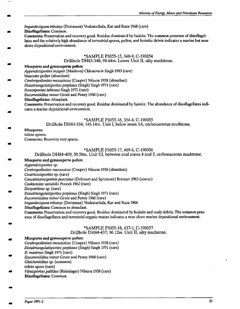
Ministry of Energy, Mines and Petmleum Resourrcs
Impardecisporu tribotys (Dettmann) Venkatachala, Kar and Raza 1968 (rare) Dinoflagellates: Common. Comments: Preservation and recovery good. Residue dominated by fusinite. The common presence of dinoflagel- lates and the relatively high abundance of terrestrial spores, pollen, and fusinitic debris indicates a marine but near shore depositional environment.
*SAMPLE P3055-15348-9, C-190054 Drillhole DH83-348; 98.44m. Lower Unit XI, silty mudstone.
Miospores and gymnosperm pollen: Appendicisporites ins&is (Markova) Chlonova in Singh 1983 (rare) biiaccate pollen (abundant) CerebropoIZenites mesozoicus (Couper) Nilsson 1958 (abundant) Distaltriangulatispotitesperpkxus (Singh) Singh 1971 (rare) Foveosporites labiosus Six@ 1971 (rare) Eucommiidites minor Groot and Penny 1960 (rare) Dinoflagellates: Abundant. Comments: Preservation and recovery good. Residue dominated by fusinite. The abundance of dinoflagellates indi- cates a marine depositional environment.
*SAMPLE P3055-16,354-4, C-190055 Drillhole DH83-354; 146.14m. Unit I, below seam lA, carbonaceous mudstone.
Miospores: trilete spores. Comments: Recovery very sparse.
*SAMPLE P3055-17,409-6, C-190056 Drillhole DH84-409; 50.58m. Unit III, between coal zones 4 and 5, carbonaceous mudstone.
Miospores and gymnosperm pollen: Appendicisporites sp. Cerebropollenites mesozoicus (Couper) Nilsson 1958 (abundant) Cicatricosisporites sp. (rare) Concavissimisporitespunctutus (Delcourt and Sprumont) Brenner 1963 (scarce) Cooksonites variabilis Pocock 1962 (rare) DictyotriIetes sp. (rare) DistaltrianguIatisporiresperplenrs (Singh) Singh 1971 (rare) Eucommiidites minor Groot and Penny 1960 (rare) Zmpardecispora tribottys (Dettmann) Venkatachala, Kar and Raza 1968 Dinoflagellates: Common to abundant. Comments: Preservation and recovery good. Residue dominated by fusinite and coaly debris. The common pres- ence of dinoflagellates and terrestrial organic matter indicates a near shore marine depositional environment.
*SAMPLE P3055-18,437-l, C-190057 Drillhole DH84-437; 96.12m. Unit II, silty mudstone.
Miospores and gymnosperm pollen: Cerebropolfenites mesozoicus (Couper) Nilsson 1958 (rare) Distalttiangulatisporiresperplexus (Singh) Singh 1971 (rare) D. maximus Singh 1971 (rare) Eucommiidites minor Groot and Penny 1960 (rare) Gleicheniidites sp. (common) trilete spore (rare) Ktreispotitespals (Reissinger) Nilsson 1958 (rare) Dinoflagellates: Common.
PaPer 199X-2 51
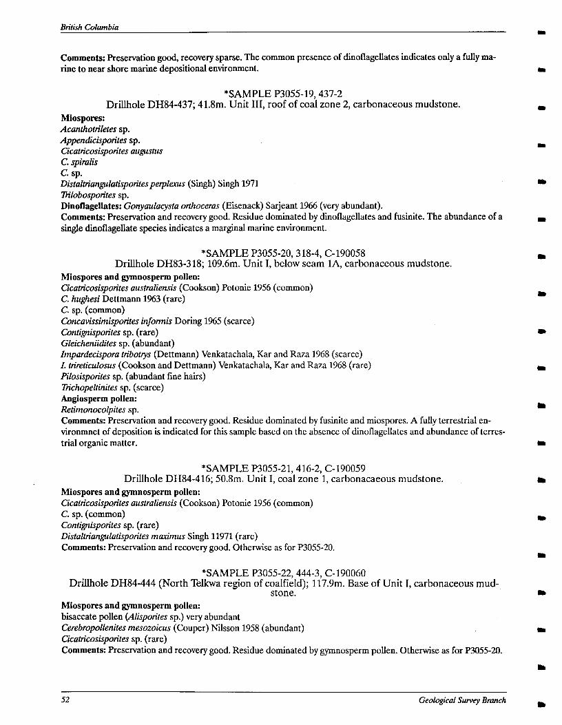
Britzkh Columbia
Comments: Preservation good, recovery sparse. The common presence of dinoflagellates indicates only a fully ma- rine to near shore marine depositional environment.
*SAMPLE P3055-19,437-2 Drillhole DH84-437; 41.8m. Unit III, roof of coal zone 2, carbonaceous mudstone.
Miospores: Acanthotn’letes sp. Appendicispotites sp. Cicatricosisporites augustus C. spiraiis c. sp. Distalttiangulutisporites peqkws (Singh) Singh 1971 Trilobospotites sp. Dinotlagellates: Gonyaulacysta orthoceras (Eisenack) Sarjeant 1966 (very abundant). Comments: Preservation and recovery good. Residue dominated by dinoflagellates and fusinite. The abundance of a single dinoflagellate species indicates a marginal marine environment.
*SAMPLE P3055-20,3 18-4, C-190058 Drillhole DH83-3 18; 109.6m. Unit I, below seam lA, carbonaceous mudstone.
Miospores and gymnosperm pollen: Cicatricosisporites australiensis (Cookson) Potonie 1956 (common) C. hughesi Dettmann 1%3 (rare) C. sp. (common) Concavissimisporites informis Doring 1965 (scarce) Contignispofites sp. (rare) Gleicheniidites sp. (abundant) Zmpardecispora tribotrys (Dettmann) Venkatachala, Kar and Raza 1968 (scarce) Z. trireticulosus (Cookson and Dettmann) Venkatachala, Kar and Raza 1968 (rare) Pilosisporites sp. (abundant fine hairs) Trichopeltinites sp. (scarce) Angiosperm pollen: Retimonocolpites sp. Comments: Preservation and recovery good. Residue dominated by fusinite and miospores. A fully terrestrial en- vironmnet of deposition is indicated for this sample based on the absence of dinoflagellates and abundance of terres- trial organic matter.
*SAMPLE P3055-21,416-2, C-190059 Drillhole DH84-416; 50.8m. Unit I, coal zone 1, carbonacaeous mudstone.
Miospores and gymnosperm pollen: Cicaticosisporites australiensis (Cookson) Potonie 1956 (common) C. sp. (common) Contignisporites sp. (rare) Distaltriangulatisporites marimus Singh 11971 (rare) Comments: Preservation and recovery good. Otherwise as for P3055-20.
*SAMPLE P3055-22,444-3, C-190060 Drillhole DH84-444 (North Telkwa region of coalfield); 117.9m. Base of Unit I, carbonaceous mud-
stone. Miospores and gymnosperm pollen: bisaccate pollen (Alispotites sp.) very abundant Cerebropollenites mesozoicus (Couper) Nilsson 1958 (abundant) Cicatricosisporites sp. (rare) Comments: Preservation and recovery good. Residue dominated by gymnosperm pollen. Otherwise as for P3055-20.
52 Geologkal Survey Bmnch
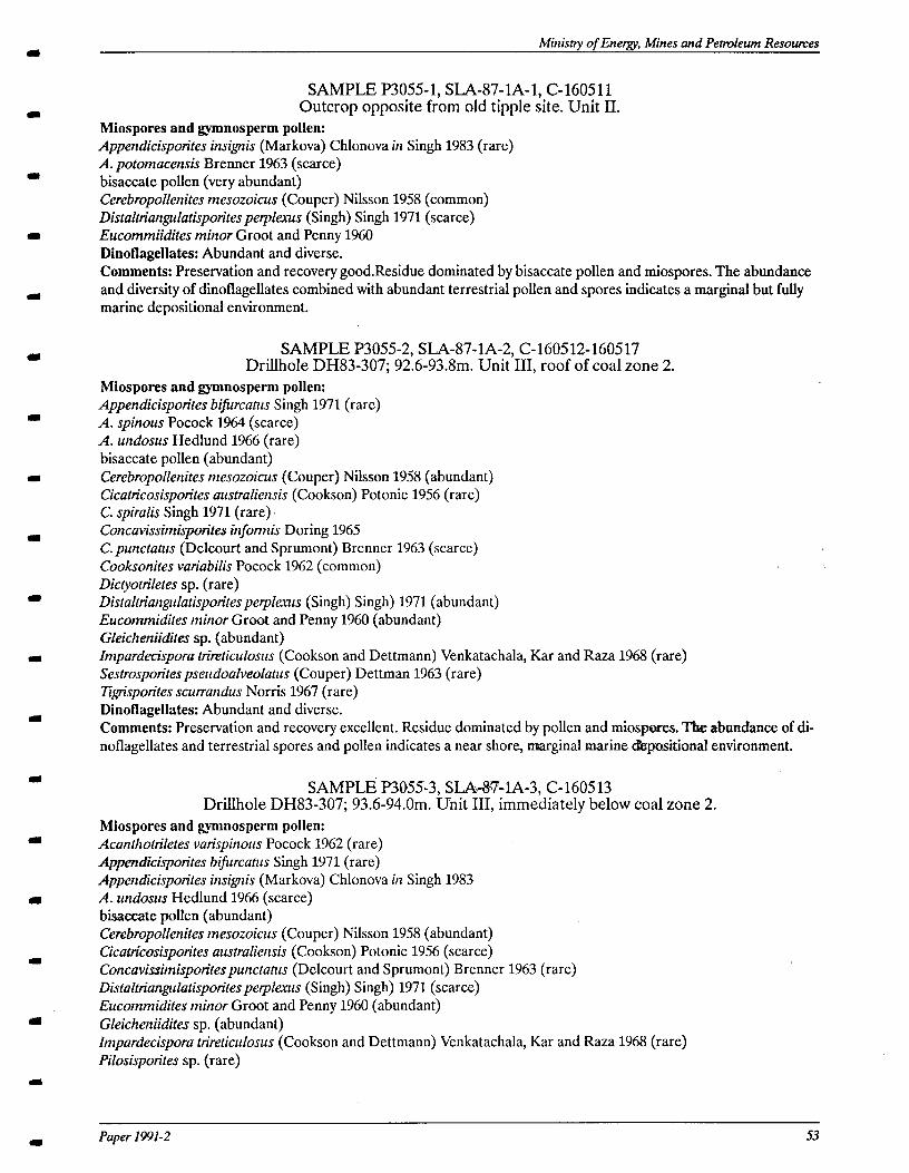
Ministty of Energy, Mines <and Petmleum Resources
SAMPLE P3055-1, SLA-87-lA-1, C-160511 Outcrop opposite from old tipple site. Unit II.
Miospores and gymnosperm pollen: Appendicisporites insignis (Markova) Chlonova in Singh 1983 (rare) A. potomacensis Brenner 1963 (scarce) bisaccate pollen (very abundant) Cerebropollenites mesozoicus (Couper) Nilsson 19.58 (common) Distaltriangulatisporitespeqokus (Singh) Singh 1971 (scarce) Eucommiidites minor Groot and Penny 1960 Dinoflagellates: Abundant and diverse. Comments: Preservation and recovery good.Residue dominated by bisaccate pollen and miospores. The abundance and diversity of dinoflagellates combined with abundant terrestrial pollen and spores indicates a marginal but fully marine depositional environment.
SAMPLE P3055-2, SLA-87-lA-2, C-160512-160517 Drillhole DH83-307; 92.6-93.8m. Unit III, roof of coal zone 2.
Miospores and gymnosperm pollen: Appendicisporites bifircatus Singh 1971 (rare) A. spinous Pocock 1964 (scarce) A. undosus Hedlund 1966 (rare) bisaccate pollen (abundant) Cerebropollenites mesozoicus (Couper) N&son 1958 (abundant) Cicatricosisporites austruliensis (Cookson) Potonie 1956 (rare) C. spiralis Singh 1971 (rare). Concavissintisporites infonnis Doring 1965 C. punctutus (Delcourt and Sprumont) Brenner 1963 (scarce) Cooksonites variabilis Pocock 1962 (common) Dictyotriletes sp. (rare) Distaltriangulatisporitespeykus (Singh) Singh) 1971 (abundant) Eucommidites minor Groat and Penny 1960 (abundant) Gleicheniidiks sp. (abundant) Impardecispora trimticulosus (Cookson and Dettmann) Venkatachala, Kar and Raza 1968 (rare) Sestrospotitespseudoalveolutus (Couper) Dettman 1963 (rare) Qrisponles scurrundus Norris 1967 (rare) Dinoflagellates: Abundant and diverse. Comments: Preservation and recovery excellent. Residue dominated by pollen and miospores. The abundance of di- noflagellates and terrestrial spores and pollen indicates a near shore, marginal marine d&positional environment.
SAMPLE‘ P3055-3, SLA&WIA-3, C-1605 13 DriLlhole DH83-307; 93.6-94.0m. Unit III, immediately below coal zone 2.
Miospores and gymnosperm pollen: Acanthottiletes varispinous Pocock 1962 (rare) Appendicisporites bifurcatis Singh 1971 (rare) Appendicisporites insignis (Markova) Chlonova in Singh 1983 A. undosus Hedlund 1966 (scarce) bisaccate polIen (abundant) Cerebropollenites mesozoicus (Couper) Nilsson 1958 (abundant) Cicatricosisporites austruliensis (Cookson) Potonie 1956 (scarce) Concavissimisporitespunctatus (Delcourt and Sprumont) Brenner 1963 (rare) Distalttiangulatisporitesperplexus (Singh) Singh) 1971 (scarce) Eucommidites minor Groot and Penny 1960 (abundant)
I Gleicheniidites sp. (abundant) Zmpardecispora trireticulosus (Cookson and Dettmann) Venkatachala, Kar and Raza 1968 (rare) Pilosisporites sp. (rare)
I Paper 1991-2 53
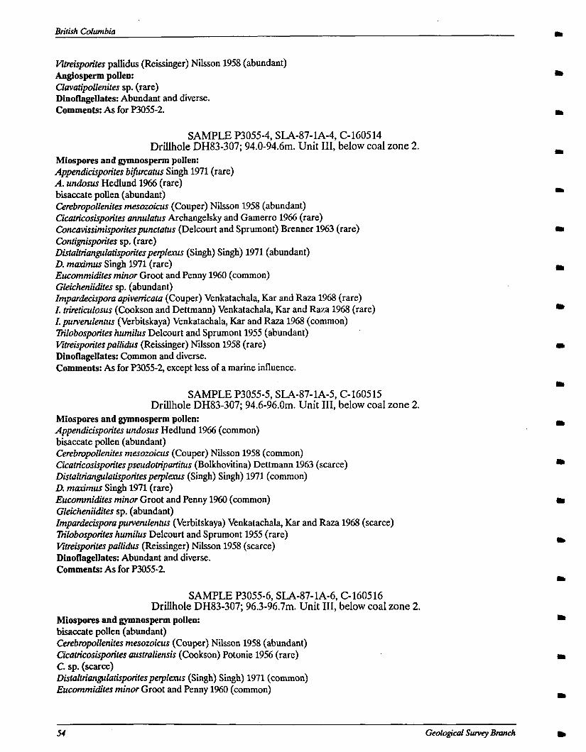
Btitish Columbia
Vitreisporites pallidus (Reissinger) Nilsson 1958 (abundant) Angiosperm pollen: Cfavutipoffenites sp. (rare) Dinoflagellates: Abundant and diverse. Comments: As for P3055-2.
SAMPLE P3055-4, SLA-87-lA-4, C-160514 Drillhole DH83-307; 94.0-94.6m. Unit III, below coal zone 2.
Miospores and gymnosperm pollen: Appendicisporites bifircatus Singb 1971 (rare) A. undosus Hedlund 1966 (rare) biiaccate pollen (abundant) Cerebropoffenites mesowicus (Couper) Nilsson 1958 (abundant) Cicaticosisporites annufatus Archangel+ and Gamerro 1966 (rare) Concuvissimisporitespunctutus (Delcourt and Sprumont) Brenner 1%3 (rare) Contignisporites sp. (rare) DistuftianguZutisporitesperpfexus (Singh) Singh) 1971 (abundant) D. muximus Singh 1971 (rare) Eucommidites minor Groot and Penny 1960 (common) Gleicheniidites sp. (abundant) Zmpardecispora apivenicata (Couper) Venkatachala, Kar and Raza 1968 (rare) Z. trireticufosus (Cookson and Dettmann) Venkatachala, Kar and Raza 1968 (rare) Z. purverulentus (Verbitskaya) Venkatachala, Kar and Raza 1968 (common) Tfilobospon’tes humifus Delcourt and Sprumont 1955 (abundant) VitteisporitespuZZidus (Reissinger) Nilsson 1958 (rare) Dinoflagellates: Common and diverse. Comments: As for F’3055-2, except less of a marine influence.
SAMPLE P3055-5, SLA-87- lA-5, C-1605 15 DriLlhole DH83-307; 94.6-96.0m. Unit III, below coal zone 2.
Miospores and gymnosperm pollen: Appendicisporites undosus Hedlund 1966 (common) bisaccate pollen (abundant) Cerebropollenites mesozoicus (Couper) Nilsson 1958 (common) Cicatricosisporitespseudottipurtitus (Bolkhovitina) Dettmann 1963 (scarce) DistalttiunguIutisporitesperplerus (Sir@) Singh) 1971 (common) D. muximus Singh 1971 (rare) Eucommidites minor Groot and Penny 1960 (common) Gfeicheniidites sp. (abundant) Zmpardecisporapurvenrfentus (Verbitskaya) Venkatachala, Kar and Raza 1968 (scarce) Ttilobosporites humifus Delcourt and Sprumont 1955 (rare) Vitreispotitespal (Reissinger) Nilsson 1958 (scarce) Dinoflagellates: Abundant and diverse. Comments: As for P3055-2.
SAMPLE P3055-6, SLA-87- lA-6, C- 1605 16 Drillbole DH83-307; 96.3-96.7m. Unit III, below coal zone 2.
Miospores and gymnosperm pollen: biiaccate pollen (abundant) Cerebropoffenites mesozoicus (Couper) Nilsson 1958 (abundant) Cicuticosisporites austrufiensis (Cookson) Potonie 1956 (rare) c. sp. (scarce) Distuftriangufutispon’resperplexus (Singh) Singh) 1971 (common) Eucommidites minor Groot and Penny 1960 (common)
54 Geological Sway Bmnch

Ministy of Energy Mines and Petroleum Resouxes
Gleicheniidites sp. (abundant) VitreisporitespuZZidus (Reissinger) Nilsson 1958 (common) Dinotlagellates: Abundant and diverse. Comments: As for P3055-2.
SAMPLE P3055-7, SLA-87-lA-7, C-160517 Drillhole DH83-307; 99.5-99.6m. Unit III, below coal zone 2.
Miospores and gymnosperm pollen: Appendicisporites bifircatus Singh 1971 (rare) A. undosus Hedlund 1966 (rare) bisaccate pollen (abundant) Cerebropollenites mesozoicus (Couper) Nilsson 1958 (abundant) DistaltrianguIatisporitespe@xus (Singh) Singh) 1971 (common) Eucommidites minor Groot and Penny 1960 (scarce) Gleicheniidites sp. (abundant) Angiosperm pollen: Raceomonocolpites sp. (rare) Dinoflagellates: Abundant and diverse. Comments: As for P3055-2.
GENERAL COMMENTS Dr. Sweet reports that dinoflagellates are present throughout the sampled portions of the coreholes, with the
exception of the samples associated with Unit I (P3055-20 to 22), indicating a close association’with marine conditions during deposition of all coal seams except those in Unit I. Unit I alone appears to have been deposited within a fully terrestrial setting. Dr. Sweet suggests that an early Albian (or possibly Aptian or Barremian) age is consistent with the observed species. The upper limit of the age range is concluded from the apparent absence of tricolpate angiosperm pollen, which occur persistently in rocks of middle and late Albian age. He adds that the palynological assemblages do not provide a means for consistently differentiating between the different units, so he considers all units to fall within the same age span.
Paper 1991-2

British Columbia
56 Geological Survey Bmnch
I
0
a
a
I
I
I
I
I SAMPLE 324-10
Ministry of Energy, Mines and Petroleum Resounzes
RESULTS OF PALEONTOLOGICAL ANALYSES Macrofossils were collected by the author and examined by Dr. Terry Poulton of the Institute of Sedimentary and
Petroleum Geology, and Dr. Paul Smith of the University of British Columbia (Poulton, G.S.C. Report J-lo-WWTPP; Smith, personal communication, 1990). Their findings are summarized in the following text. All samples are from the Goathorn region of the Telkwa coalfield, except sample C-187199, which is from the North Telkwa region.
Samples examined by Dr. Poulton: SAMPLE C- 187200,336- 1
DriLlhole DH83-336; 106.2m. Silty mudstone, Unit II. Myophorella (Yaadia) sp. Albian (?)
SAMPLE C-187198,348-13 DriLlhole DH83-348; 80Sm. Silty mudstone, Unit II.
Columbitrigonia sp. This specimen may represent a new species, perhaps intermediate between C. columbiana and C. jackassensis. Albian (?)
Myophorella (Xiadia) sp. Albian (?)
SAMPLE C-187199,811-11 Drillhole 811; 124.2m. Mottled sandstone, Unit II.
Dr. Poulton reports that the specimens are not well enough preserved to identify nor date precisely; but that they are closely similar to Albian species previously described from British Columbia, and also have similarities to others as old as Barremian. He also adds that older and younger dates cannot be ruled out either and that the total possible age range should be considered as Hauterivian(?) to Cenomanian.
Samples examined by Dr. Smith: SAMPLE 322-2
Drillhole DH83-322; 174.4m. Silty mudstone, top of Unit II. Unidentifiable bivalves. Probably marine.
SAMPLE 324-5 Drillhole DH83-324; 54Sm. Silty mudstone, Unit II.
Inoceramid-like fragments. Marine.
Dritlhole DH83-324; 18m. Bioturbated sandstone, Unit III. Unidentifable diverse assemblage with a specimen showing divaricate ornament. Marine.
SAMPLE 330-5
Paper 1991-2 57
British Columbia
Bivalve (Fulpia?) Marine.
Drillhole DH83-330; 1457m. Silty mudstone, Unit II.
Unidentifiable bivalves. Probably marine.
SAMPLE 336-2 Drillhole DH336; 96Sm. Silty mudstone, Unit II.
Unidentifiable bivalves. Probably marine.
SAMPLE 348-7 Drillhole DH83-348; 99. lm. Silty mudstone, Unit II.
Dentalium ? sp. Marine.
SAMPLE 354-13 Drillhole DH83-354; 39m. Silty mudstone, Unit II.
58 Geological Survey Brunch
Ministy of Energy, Mines and Pebvleum Resoutus
APPENDIX III
TYPICAL SANDSTONE COMPOSITION OF LOWER SKEENA GROUP (based on thin section analysis-visual estimation)
UNIT I FRAMEWORK: Chert 30% Quartz Monocrystalline 15% Hexagonal, embayed Polycrystalline :z Rock Fragments topiary (other than chert) 10%
20% a Metamorphic? (stretched quartz) minor
Feldspar Plagioclase 5% Potassium feldspar minor
II Muscovite minor Chlorite minor MATRIX: Carbonate, with some iron oxide (hematite?) cement
d UNIT II, III AND IV
FRAMEWORK: Chert
a Quartz Monocrystalline Polycrystalline Rock Fragments
I Sedimentary (other than chert) Volcanic Metamorphic? (stretched quartz) Feldspar
(I Plagioclase Potassium feldspar Muscovite Chlorite
0 MATRIX: Clay minerals and dark carbonaceous matter
BASAL SANTXTONE; UNIT IV a FRAMEWORK:
Chert Quartz
u Monocrystallme Polycrystalline Rock Fragments Sedimentary (other than chert) Volcanic
II Metamorphic? (stretched quartz) Feldspar Plagioclase Potassium feldspar
a Muscovite Chlorite MATRIX: Clay minerals and dark carbonaceous matter
30%
25% minor
25% minor minor
minor minor <5% 15%
25%
15% minor
15% minor minor
minor minor
4zI
I Paper 1 WI-2

British Columbia
60 Geological Survey Branch m