Stratigraphy and sedimentology of the Niger Delta · Stratigraphy and sedimentology of the Niger...
30
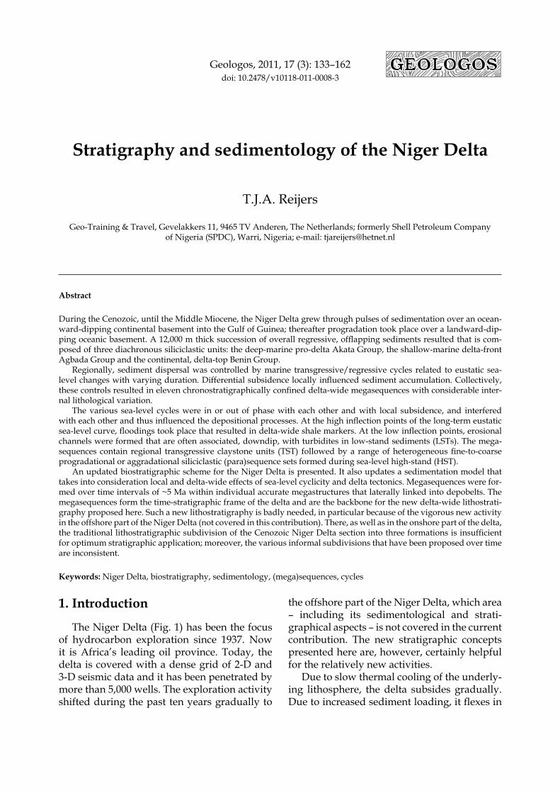
Geologos, 2011, 17 (3): 133–162 doi: 10.2478/v10118-011-0008-3 Stratigraphy and sedimentology of the Niger Delta T.J.A. Reijers Geo-Training & Travel, Gevelakkers 11, 9465 TV Anderen, The Netherlands; formerly Shell Petroleum Company of Nigeria (SPDC), Warri, Nigeria; e-mail: [email protected] Abstract During the Cenozoic, until the Middle Miocene, the Niger Delta grew through pulses of sedimentation over an ocean- ward-dipping continental basement into the Gulf of Guinea; thereafter progradation took place over a landward-dip- ping oceanic basement. A 12,000 m thick succession of overall regressive, offlapping sediments resulted that is com- posed of three diachronous siliciclastic units: the deep-marine pro-delta Akata Group, the shallow-marine delta-front Agbada Group and the continental, delta-top Benin Group. Regionally, sediment dispersal was controlled by marine transgressive/regressive cycles related to eustatic sea- level changes with varying duration. Differential subsidence locally influenced sediment accumulation. Collectively, these controls resulted in eleven chronostratigraphically confined delta-wide megasequences with considerable inter- nal lithological variation. The various sea-level cycles were in or out of phase with each other and with local subsidence, and interfered with each other and thus influenced the depositional processes. At the high inflection points of the long-term eustatic sea-level curve, floodings took place that resulted in delta-wide shale markers. At the low inflection points, erosional channels were formed that are often associated, downdip, with turbidites in low-stand sediments (LSTs). The mega- sequences contain regional transgressive claystone units (TST) followed by a range of heterogeneous fine-to-coarse progradational or aggradational siliciclastic (para)sequence sets formed during sea-level high-stand (HST). An updated biostratigraphic scheme for the Niger Delta is presented. It also updates a sedimentation model that takes into consideration local and delta-wide effects of sea-level cyclicity and delta tectonics. Megasequences were for- med over time intervals of ~5 Ma within individual accurate megastructures that laterally linked into depobelts. The megasequences form the time-stratigraphic frame of the delta and are the backbone for the new delta-wide lithostrati- graphy proposed here. Such a new lithostratigraphy is badly needed, in particular because of the vigorous new activity in the offshore part of the Niger Delta (not covered in this contribution). There, as well as in the onshore part of the delta, the traditional lithostratigraphic subdivision of the Cenozoic Niger Delta section into three formations is insufficient for optimum stratigraphic application; moreover, the various informal subdivisions that have been proposed over time are inconsistent. Keywords: Niger Delta, biostratigraphy, sedimentology, (mega)sequences, cycles 1. Introduction The Niger Delta (Fig. 1) has been the focus of hydrocarbon exploration since 1937. Now it is Africa’s leading oil province. Today, the delta is covered with a dense grid of 2-D and 3-D seismic data and it has been penetrated by more than 5,000 wells. The exploration activity shifted during the past ten years gradually to the offshore part of the Niger Delta, which area – including its sedimentological and strati- graphical aspects – is not covered in the current contribution. The new stratigraphic concepts presented here are, however, certainly helpful for the relatively new activities. Due to slow thermal cooling of the underly- ing lithosphere, the delta subsides gradually. Due to increased sediment loading, it flexes in
Transcript of Stratigraphy and sedimentology of the Niger Delta · Stratigraphy and sedimentology of the Niger...
Geologos, 2011, 17 (3): 133–162doi: 10.2478/v10118-011-0008-3
Stratigraphy and sedimentology of the Niger Delta
T.J.A. Reijers
Geo-Training & Travel, Gevelakkers 11, 9465 TV Anderen, The Netherlands; formerly Shell Petroleum Company of Nigeria (SPDC), Warri, Nigeria; e-mail: [email protected]
Abstract
During the Cenozoic, until the Middle Miocene, the Niger Delta grew through pulses of sedimentation over an ocean-ward-dipping continental basement into the Gulf of Guinea; thereafter progradation took place over a landward-dip-ping oceanic basement. A 12,000 m thick succession of overall regressive, offlapping sediments resulted that is com-posed of three diachronous siliciclastic units: the deep-marine pro-delta Akata Group, the shallow-marine delta-front Agbada Group and the continental, delta-top Benin Group.
Regionally, sediment dispersal was controlled by marine transgressive/regressive cycles related to eustatic sea-level changes with varying duration. Differential subsidence locally influenced sediment accumulation. Collectively, these controls resulted in eleven chronostratigraphically confined delta-wide megasequences with considerable inter-nal lithological variation.
The various sea-level cycles were in or out of phase with each other and with local subsidence, and interfered with each other and thus influenced the depositional processes. At the high inflection points of the long-term eustatic sea-level curve, floodings took place that resulted in delta-wide shale markers. At the low inflection points, erosional channels were formed that are often associated, downdip, with turbidites in low-stand sediments (LSTs). The mega-sequences contain regional transgressive claystone units (TST) followed by a range of heterogeneous fine-to-coarse progradational or aggradational siliciclastic (para)sequence sets formed during sea-level high-stand (HST).
An updated biostratigraphic scheme for the Niger Delta is presented. It also updates a sedimentation model that takes into consideration local and delta-wide effects of sea-level cyclicity and delta tectonics. Megasequences were for-med over time intervals of ~5 Ma within individual accurate megastructures that laterally linked into depobelts. The megasequences form the time-stratigraphic frame of the delta and are the backbone for the new delta-wide lithostrati-graphy proposed here. Such a new lithostratigraphy is badly needed, in particular because of the vigorous new activity in the offshore part of the Niger Delta (not covered in this contribution). There, as well as in the onshore part of the delta, the traditional lithostratigraphic subdivision of the Cenozoic Niger Delta section into three formations is insufficient for optimum stratigraphic application; moreover, the various informal subdivisions that have been proposed over time are inconsistent.
Keywords: Niger Delta, biostratigraphy, sedimentology, (mega)sequences, cycles
1. Introduction
The Niger Delta (Fig. 1) has been the focus of hydrocarbon exploration since 1937. Now it is Africa’s leading oil province. Today, the delta is covered with a dense grid of 2-D and 3-D seismic data and it has been penetrated by more than 5,000 wells. The exploration activity shifted during the past ten years gradually to
the offshore part of the Niger Delta, which area – including its sedimentological and strati-graphical aspects – is not covered in the current contribution. The new stratigraphic concepts presented here are, however, certainly helpful for the relatively new activities.
Due to slow thermal cooling of the underly-ing lithosphere, the delta subsides gradually. Due to increased sediment loading, it flexes in
134 T.J.A. Reijers
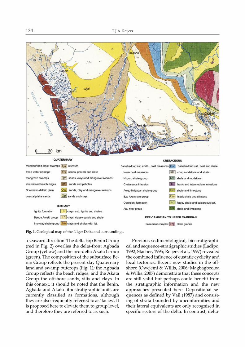
a seaward direction. The delta-top Benin Group (red in Fig. 2) overlies the delta-front Agbada Group (yellow) and the pro-delta Akata Group (green). The composition of the subsurface Be-nin Group reflects the present-day Quaternary land and swamp outcrops (Fig. 1); the Agbada Group reflects the beach ridges, and the Akata Group the offshore sands, silts and clays. In this context, it should be noted that the Benin, Agbada and Akata lithostratigraphic units are currently classified as formations, although they are also frequently referred to as ‘facies’. It is proposed here to elevate them to group level, and therefore they are referred to as such.
Previous sedimentological, biostratigraphi-cal and sequence-stratigraphic studies (Ladipo, 1992; Stacher, 1995; Reijers et al., 1997) revealed the combined influence of eustatic cyclicity and local tectonics. Recent new studies in the off-shore (Owejemi & Willis, 2006; Magbagbeoloa & Willis, 2007) demonstrate that these concepts are still valid but perhaps could benefit from the stratigraphic information and the new approaches presented here. Depositional se-quences as defined by Vail (1987) and consist-ing of strata bounded by unconformities and their lateral equivalents are only recognised in specific sectors of the delta. In contrast, delta-
Fig. 1. Geological map of the Niger Delta and surroundings.
Stratigraphy and sedimentology of the Niger Delta 135
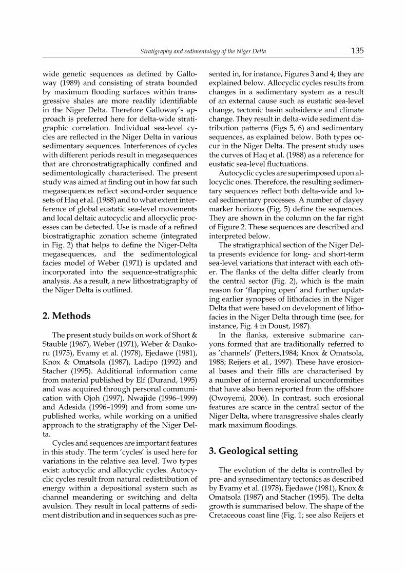
wide genetic sequences as defined by Gallo-way (1989) and consisting of strata bounded by maximum flooding surfaces within trans-gressive shales are more readily identifiable in the Niger Delta. Therefore Galloway’s ap-proach is preferred here for delta-wide strati-graphic correlation. Individual sea-level cy-cles are reflected in the Niger Delta in various sedimentary sequences. Interferences of cycles with different periods result in megasequences that are chronostratigraphically confined and sedimentologically characterised. The present study was aimed at finding out in how far such megasequences reflect second-order sequence sets of Haq et al. (1988) and to what extent inter-ference of global eustatic sea-level movements and local deltaic autocyclic and allocyclic proc-esses can be detected. Use is made of a refined biostratigraphic zonation scheme (integrated in Fig. 2) that helps to define the Niger-Delta megasequences, and the sedimentological facies model of Weber (1971) is updated and incorporated into the sequence-stratigraphic analysis. As a result, a new lithostratigraphy of the Niger Delta is outlined.
2. Methods
The present study builds on work of Short & Stauble (1967), Weber (1971), Weber & Dauko-ru (1975), Evamy et al. (1978), Ejedawe (1981), Knox & Omatsola (1987), Ladipo (1992) and Stacher (1995). Additional information came from material published by Elf (Durand, 1995) and was acquired through personal communi-cation with Ojoh (1997), Nwajide (1996–1999) and Adesida (1996–1999) and from some un-published works, while working on a unified approach to the stratigraphy of the Niger Del-ta.
Cycles and sequences are important features in this study. The term ‘cycles’ is used here for variations in the relative sea level. Two types exist: autocyclic and allocyclic cycles. Autocy-clic cycles result from natural redistribution of energy within a depositional system such as channel meandering or switching and delta avulsion. They result in local patterns of sedi-ment distribution and in sequences such as pre-
sented in, for instance, Figures 3 and 4; they are explained below. Allocyclic cycles results from changes in a sedimentary system as a result of an external cause such as eustatic sea-level change, tectonic basin subsidence and climate change. They result in delta-wide sediment dis-tribution patterns (Figs 5, 6) and sedimentary sequences, as explained below. Both types oc-cur in the Niger Delta. The present study uses the curves of Haq et al. (1988) as a reference for eustatic sea-level fluctuations.
Autocyclic cycles are superimposed upon al-locyclic ones. Therefore, the resulting sedimen-tary sequences reflect both delta-wide and lo-cal sedimentary processes. A number of clayey marker horizons (Fig. 5) define the sequences. They are shown in the column on the far right of Figure 2. These sequences are described and interpreted below.
The stratigraphical section of the Niger Del-ta presents evidence for long- and short-term sea-level variations that interact with each oth-er. The flanks of the delta differ clearly from the central sector (Fig. 2), which is the main reason for ‘flapping open’ and further updat-ing earlier synopses of lithofacies in the Niger Delta that were based on development of litho-facies in the Niger Delta through time (see, for instance, Fig. 4 in Doust, 1987).
In the flanks, extensive submarine can-yons formed that are traditionally referred to as ’channels’ (Petters,1984; Knox & Omatsola, 1988; Reijers et al., 1997). These have erosion-al bases and their fills are characterised by a number of internal erosional unconformities that have also been reported from the offshore (Owoyemi, 2006). In contrast, such erosional features are scarce in the central sector of the Niger Delta, where transgressive shales clearly mark maximum floodings.
3. Geological setting
The evolution of the delta is controlled by pre- and synsedimentary tectonics as described by Evamy et al. (1978), Ejedawe (1981), Knox & Omatsola (1987) and Stacher (1995). The delta growth is summarised below. The shape of the Cretaceous coast line (Fig. 1; see also Reijers et
136 T.J.A. Reijers
al., 1997) gradually changed with the growth of the Niger Delta (Figs 3, 4). A bulge devel-oped due to delta growth. This changing coast-line interacted with the palaeo-circulation pat-tern and controlled the extent of incursions of
the sea (Reijers et al., 1997). Other factors that controlled the growth of the delta are climatic variations and the proximity and nature of sed-iment source areas.
Fig 2. Stratigraphic data sheet (west and east halves combined) of the Niger Delta.
Stratigraphy and sedimentology of the Niger Delta 137
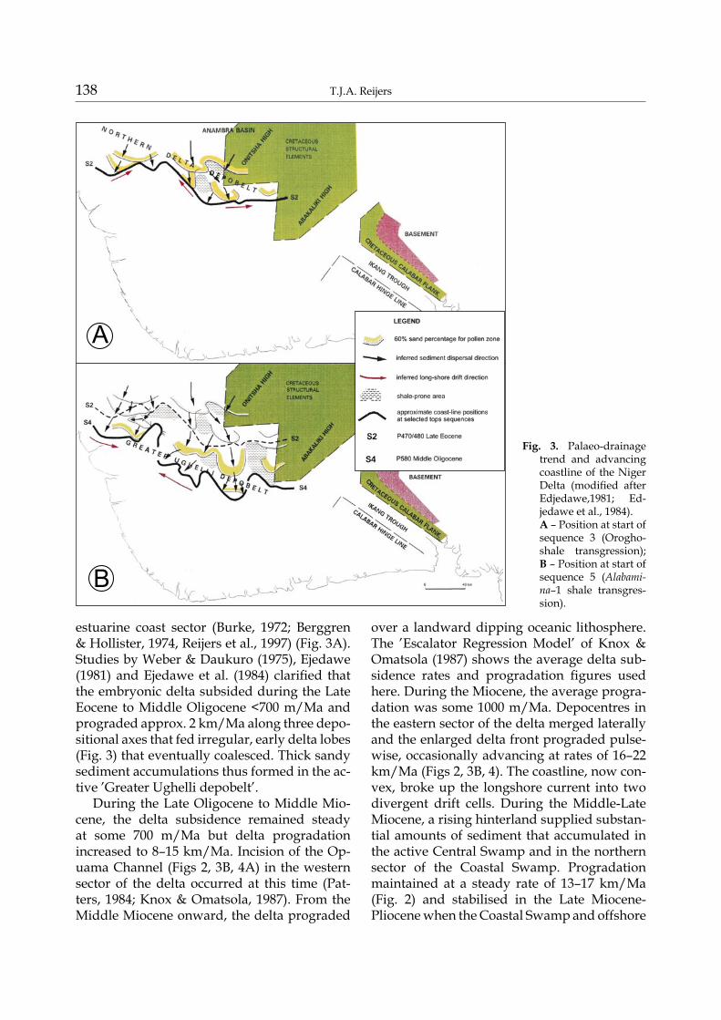
During the Middle-Late Eocene, sediment was deposited (Fig. 3A) west of the inverted Cretaceous Abakaliki High and south of the Anambra Basin in what became the ’north-ern depobelt of the Niger Delta’ (Figs 1, 3,
4). The first coarse clastic deposits have been dated on the basis of microfloral units (Evamy et al., 1978) (Fig. 2; Table 1) as Early Eocene. Tradewinds generated longshore currents with two cells converging along the western
Fig 2. cont.
138 T.J.A. Reijers
estuarine coast sector (Burke, 1972; Berggren & Hollister, 1974, Reijers et al., 1997) (Fig. 3A). Studies by Weber & Daukuro (1975), Ejedawe (1981) and Ejedawe et al. (1984) clarified that the embryonic delta subsided during the Late Eocene to Middle Oligocene <700 m/Ma and prograded approx. 2 km/Ma along three depo-sitional axes that fed irregular, early delta lobes (Fig. 3) that eventually coalesced. Thick sandy sediment accumulations thus formed in the ac-tive ’Greater Ughelli depobelt’.
During the Late Oligocene to Middle Mio-cene, the delta subsidence remained steady at some 700 m/Ma but delta progradation increased to 8–15 km/Ma. Incision of the Op-uama Channel (Figs 2, 3B, 4A) in the western sector of the delta occurred at this time (Pat-ters, 1984; Knox & Omatsola, 1987). From the Middle Miocene onward, the delta prograded
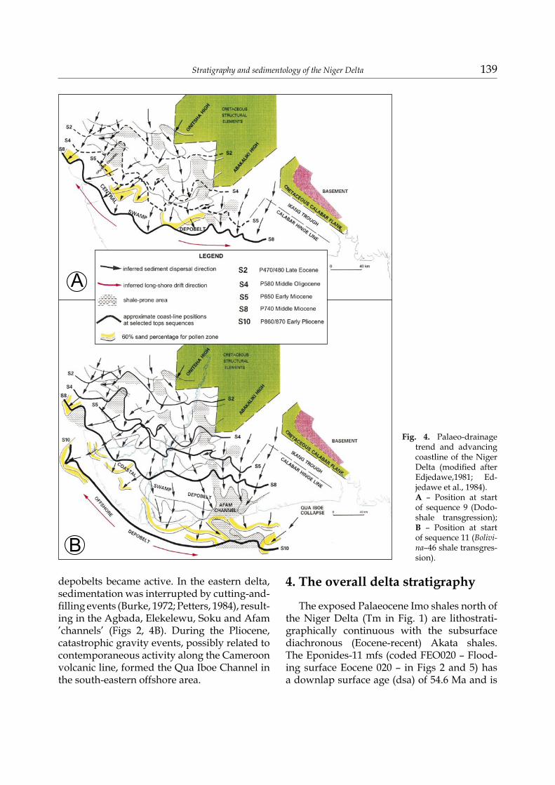
over a landward dipping oceanic lithosphere. The ’Escalator Regression Model’ of Knox & Omatsola (1987) shows the average delta sub-sidence rates and progradation figures used here. During the Miocene, the average progra-dation was some 1000 m/Ma. Depocentres in the eastern sector of the delta merged laterally and the enlarged delta front prograded pulse-wise, occasionally advancing at rates of 16–22 km/Ma (Figs 2, 3B, 4). The coastline, now con-vex, broke up the longshore current into two divergent drift cells. During the Middle-Late Miocene, a rising hinterland supplied substan-tial amounts of sediment that accumulated in the active Central Swamp and in the northern sector of the Coastal Swamp. Progradation maintained at a steady rate of 13–17 km/Ma (Fig. 2) and stabilised in the Late Miocene-Pliocene when the Coastal Swamp and offshore
Fig. 3. Palaeo-drainage trend and advancing coastline of the Niger Delta (modified after Edjedawe,1981; Ed-jedawe et al., 1984). A – Position at start of sequence 3 (Orogho-shale transgression); B – Position at start of sequence 5 (Alabami-na–1 shale transgres-sion).
Stratigraphy and sedimentology of the Niger Delta 139
depobelts became active. In the eastern delta, sedimentation was interrupted by cutting-and-filling events (Burke, 1972; Petters, 1984), result-ing in the Agbada, Elekelewu, Soku and Afam ’channels’ (Figs 2, 4B). During the Pliocene, catastrophic gravity events, possibly related to contemporaneous activity along the Cameroon volcanic line, formed the Qua Iboe Channel in the south-eastern offshore area.
4. The overall delta stratigraphy
The exposed Palaeocene Imo shales north of the Niger Delta (Tm in Fig. 1) are lithostrati-graphically continuous with the subsurface diachronous (Eocene-recent) Akata shales. The Eponides-11 mfs (coded FEO020 – Flood-ing surface Eocene 020 – in Figs 2 and 5) has a downlap surface age (dsa) of 54.6 Ma and is
Fig. 4. Palaeo-drainage trend and advancing coastline of the Niger Delta (modified after Edjedawe,1981; Ed-jedawe et al., 1984). A – Position at start of sequence 9 (Dodo- shale transgression); B – Position at start of sequence 11 (Bolivi-na–46 shale transgres-sion).
140 T.J.A. Reijers
the first delta-wide maximum flooding surface in the Niger Delta; it marks the beginning of the delta fill.
The traditional Benin, Agbada and Aka-ta lithostratigraphic units that compose the delta are currently formations. It is proposed
here to elevate them to group level. This fa-cilitates the introduction of several other units at formation level, as proposed below. The present contribution does not go beyond sug-gestions and proposals for formation ‘candi-dates’, as actual implementation is best done
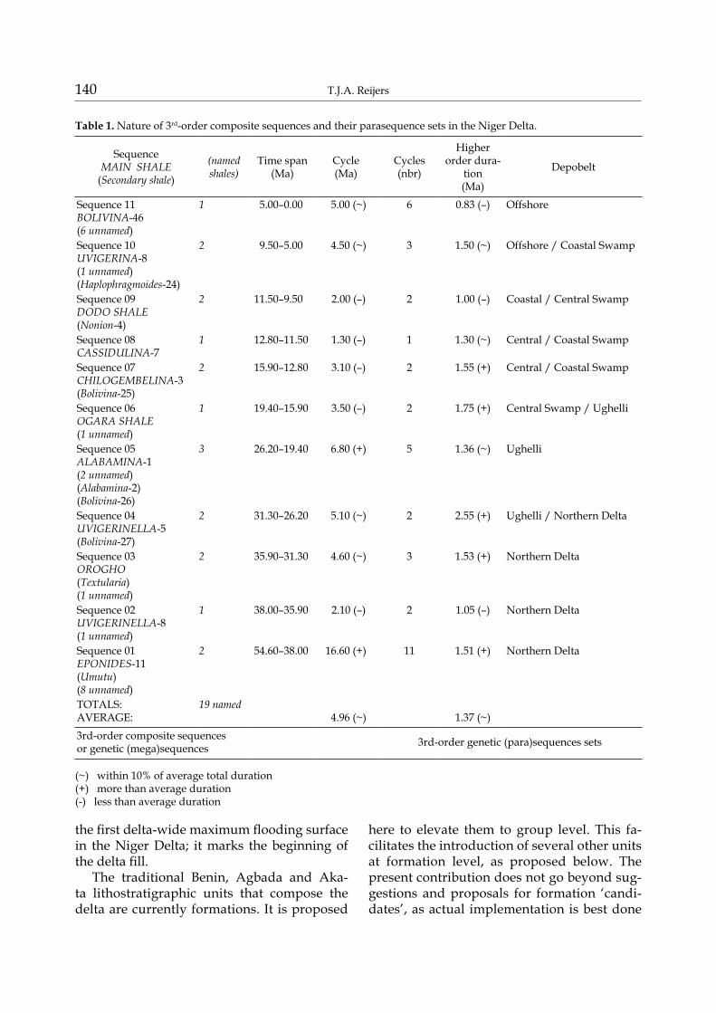
Table 1. Nature of 3rd-order composite sequences and their parasequence sets in the Niger Delta.
SequenceMAIN SHALE
(Secondary shale)
(named shales)
Time span(Ma)
Cycle(Ma)
Cycles(nbr)
Higher order dura-
tion(Ma)
Depobelt
Sequence 11 BOLIVINA-46(6 unnamed)
1 5.00–0.00 5.00 (~) 6 0.83 (–) Offshore
Sequence 10 UVIGERINA-8(1 unnamed)(Haplophragmoides-24)
2 9.50–5.00 4.50 (~) 3 1.50 (~) Offshore / Coastal Swamp
Sequence 09 DODO SHALE(Nonion-4)
2 11.50–9.50 2.00 (–) 2 1.00 (–) Coastal / Central Swamp
Sequence 08 CASSIDULINA-7
1 12.80–11.50 1.30 (–) 1 1.30 (~) Central / Coastal Swamp
Sequence 07 CHILOGEMBELINA-3(Bolivina-25)
2 15.90–12.80 3.10 (–) 2 1.55 (+) Central / Coastal Swamp
Sequence 06 OGARA SHALE(1 unnamed)
1 19.40–15.90 3.50 (–) 2 1.75 (+) Central Swamp / Ughelli
Sequence 05 ALABAMINA-1(2 unnamed)(Alabamina-2)(Bolivina-26)
3 26.20–19.40 6.80 (+) 5 1.36 (~) Ughelli
Sequence 04 UVIGERINELLA-5(Bolivina-27)
2 31.30–26.20 5.10 (~) 2 2.55 (+) Ughelli / Northern Delta
Sequence 03 OROGHO(Textularia)(1 unnamed)
2 35.90–31.30 4.60 (~) 3 1.53 (+) Northern Delta
Sequence 02 UVIGERINELLA-8(1 unnamed)
1 38.00–35.90 2.10 (–) 2 1.05 (–) Northern Delta
Sequence 01 EPONIDES-11(Umutu)(8 unnamed)
2 54.60–38.00 16.60 (+) 11 1.51 (+) Northern Delta
TOTALS: AVERAGE:
19 named 4.96 (~) 1.37 (~)
3rd-order composite sequencesor genetic (mega)sequences 3rd-order genetic (para)sequences sets
(~) within 10% of average total duration(+) more than average duration(-) less than average duration
Stratigraphy and sedimentology of the Niger Delta 141
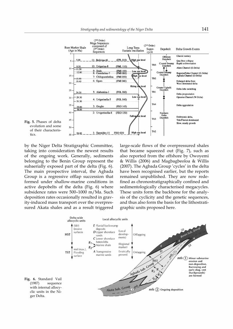
by the Niger Delta Stratigraphic Committee, taking into consideration the newest results of the ongoing work. Generally, sediments belonging to the Benin Group represent the subaerially exposed part of the delta (Fig. 6). The main prospective interval, the Agbada Group is a regressive offlap succession that formed under shallow-marine conditions in active depobelts of the delta (Fig. 6) where subsidence rates were 500–1000 m/Ma. Such deposition rates occasionally resulted in grav-ity-induced mass transport over the overpres-sured Akata shales and as a result triggered
large-scale flows of the overpressured shales that became squeezed out (Fig. 7), such as also reported from the offshore by Owoyemi & Willis (2006) and Magbagbeoloa & Willis (2007). The Agbada Group ’cycles’ in the delta have been recognised earlier, but the reports remained unpublished. They are now rede-fined as chronostratigraphically confined and sedimentologically characterised megacycles. These units form the backbone for the analy-sis of the cyclicity and the genetic sequences, and thus also form the basis for the lithostrati-graphic units proposed here.
Fig. 5. Phases of delta evolution and some of their characteris-tics.
Fig. 6. Standard Vail (1987) sequence with internal allocy-clic units in the Ni-ger Delta.
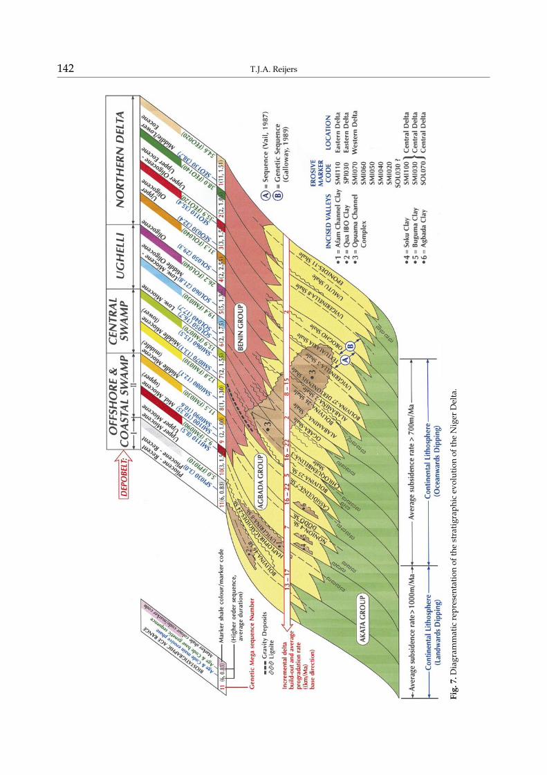
142 T.J.A. Reijers
Fig.
7. D
iagr
amm
atic
repr
esen
tatio
n of
the
stra
tigra
phic
evo
lutio
n of
the
Nig
er D
elta
.
Stratigraphy and sedimentology of the Niger Delta 143
Fig.
8. R
egio
nal N
-S lo
g co
rrel
atio
n (fo
r loc
atio
n se
e Fi
g. 8
).
144 T.J.A. Reijers
4.1. The Middle Eocene (54.6–38.0 Ma) Eponides-11 genetic megasequence
4.1.1. StratigraphyThe Eponides africana (Eponides-11) marker
shale (54.6 Ma) (Figs 2, 3A, 5–7; Table 1) re-flects a high eustatic sea-level stand resulting in seismically well correlatable flooding surfac-es. It defines the base of the Eponides-11 mega-sequence in the northern delta and the Greater Ughelli depobelts. Comparison with Haq et al.‘s (1988) chronostratigraphic scheme shows that the megasequence should contain eleven higher-order sequences (Fig. 2; Table 1). These are, however, poorly represented in the thin sediment packages within the northern delta depobelt.
The Eponides-11 megasequence ends with a fossiliferous, glauconitic sand marker (SEO 130 at 38.7Ma) (Figs 2, 7) at Haq et al.’s chron-ostratigraphic scheme. The higher-order trans-gressive Umutu shale (41.0 Ma) (Haq et al., 1988) (as 2, 3a, 12) is correlatable in the north-ern delta depobelt only.
Within the Eponides-11 megasequence, three lithostratigraphic units are candidates for for-mation rank: the basal Eponides-11 and the in-termediate Umutu transgressive shales, and the glauconitic marker sand.
4.1.2. SedimentologyAn overall progradation of <2 km/Ma
and a subsidence rate of <700m/Ma (Knox & Omatsola, 1988) in combination with weak longshore currents influenced delta growth (Fig. 3: coastline S2). The northern delta de-pobelt was passive during the formation of the upper part of the megasequence. Littoral and lower coastal-plain deposits accumulated. Shoreface sediments formed simultaneously in the active Greater Ughelli depobelt.
Shelf accommodation was reduced during phases of sea-level low-stand, and sediments bypassed the shelf and formed turbidites and gravity deposits as found in wells Aruose-1, Igualaba-1 and Oben-1.
4.2. The Late Eocene (38.0–35.9 Ma) Uvigerinella-8 genetic megasequence
4.2.1. StratigraphyThe Late Eocene Uvigerinella hourcqi (Uvige-
rinella-8) isochronous shale of 38.0 Ma (Figs 2, 3A, 5, 7, 8; Table 1) can be traced over some 70 km updip by wireline-log response and on the basis of its seismic characteristics. It defines the base of the Uvigerinella-8 megasequence that extends basinwards into the Greater Ughelli depobelt. Lithostratigraphically the Uvigerinel-la-8 shale is a candidate for formation rank.
4.2.2. SedimentologyTwo higher-order sequences are separated
by a yet unnamed local transgressive shale that is a candidate for formation status. Delta sub-sidence and progradation rates followed those of megasequence 1 (Knox & Omatsola, 1988). In the active Greater Ughelli depobelt, the Late Eocene shoreface deposits grade downdip into pro-delta / open-marine deposits.
4.3. The Early Oligocene (35.9–31.3 Ma) Orogho genetic megasequence
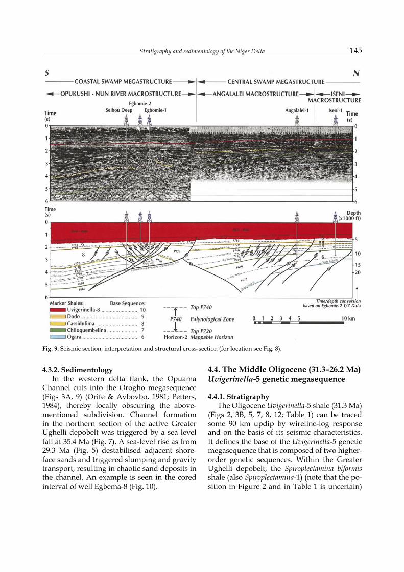
4.3.1. StratigraphyThe Orogho shale (35.9 Ma) (Figs 2, 3A, 5,
7, 8; Table 1), named after a locality, is particu-larly rich in dinocyst assemblages which delin-eate the Eocene/Oligocene boundary at 35.4 Ma. The base of the shale is also the base of the Orogho megasequence. On top of this shale, an areally extensive sand (32.4Ma), a candidate for formation status, occurs.
The locally significant Textularia-3 shale marker (34.0 Ma) (Figs 2, 3A, 9) separates the megasequence sands into two units. Locally, the Opuama Formation cuts the megasequence. The Opuama Formation has already been in-troduced as a stratigraphic unit; the Orogho megasequence and the Textularia-3 shales are candidates for a formation rank and the exten-sive sand perhaps as a member.
Stratigraphy and sedimentology of the Niger Delta 145
4.3.2. SedimentologyIn the western delta flank, the Opuama
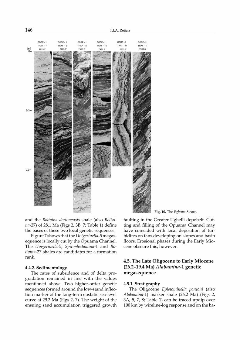
Channel cuts into the Orogho megasequence (Figs 3A, 9) (Orife & Avbovbo, 1981; Petters, 1984), thereby locally obscuring the above-mentioned subdivision. Channel formation in the northern section of the active Greater Ughelli depobelt was triggered by a sea level fall at 35.4 Ma (Fig. 7). A sea-level rise as from 29.3 Ma (Fig. 5) destabilised adjacent shore-face sands and triggered slumping and gravity transport, resulting in chaotic sand deposits in the channel. An example is seen in the cored interval of well Egbema-8 (Fig. 10).
4.4. The Middle Oligocene (31.3–26.2 Ma) Uvigerinella-5 genetic megasequence
4.4.1. StratigraphyThe Oligocene Uvigerinella-5 shale (31.3 Ma)
(Figs 2, 3B, 5, 7, 8, 12; Table 1) can be traced some 90 km updip by wireline-log response and on the basis of its seismic characteristics. It defines the base of the Uvigerinella-5 genetic megasequence that is composed of two higher-order genetic sequences. Within the Greater Ughelli depobelt, the Spiroplectamina biformis shale (also Spiroplectamina-1) (note that the po-sition in Figure 2 and in Table 1 is uncertain)
Fig. 9. Seismic section, interpretation and structural cross-section (for location see Fig. 8).
146 T.J.A. Reijers
and the Bolivina dertonensis shale (also Bolivi-na-27) of 28.1 Ma (Figs 2, 3B, 7; Table 1) define the bases of these two local genetic sequences.
Figure 7 shows that the Uvigerinella-5 megas-equence is locally cut by the Opuama Channel. The Uvigerinella-5, Spiroplectamina-1 and Bo-livina-27 shales are candidates for a formation rank.
4.4.2. SedimentologyThe rates of subsidence and of delta pro-
gradation remained in line with the values mentioned above. Two higher-order genetic sequences formed around the low-stand inflec-tion marker of the long-term eustatic sea-level curve at 29.3 Ma (Figs 2, 7). The weight of the ensuing sand accumulation triggered growth
faulting in the Greater Ughelli depobelt. Cut-ting and filling of the Opuama Channel may have coincided with local deposition of tur-bidites on fans developing on slopes and basin floors. Erosional phases during the Early Mio-cene obscure this, however.
4.5. The Late Oligocene to Early Miocene (26.2–19.4 Ma) Alabamina-1 genetic megasequence
4.5.1. StratigraphyThe Oligocene Epistominella pontoni (also
Alabamina-1) marker shale (26.2 Ma) (Figs 2, 3A, 5, 7, 8; Table 1) can be traced updip over 100 km by wireline-log response and on the ba-
Fig. 10. The Egbema-8 core.
Stratigraphy and sedimentology of the Niger Delta 147
sis of its seismic characteristics. It defines the base of the Alabamina-1 megasequence. Barrier facies within the Greater Ughelli depobelt are, due to delta-lobe switching, locally punctuated by the Bolivina beryichi or Bolivina-26 shale (23.2 Ma) (Table 1) and the Megastomella africana (Alabamina-2) shale (20.7 Ma). The Alabamina-1 megasequence is locally cut by the Opuama Channel (Figs 3A, 7).
Various intervals within the Opuama chan-nel fill are candidates for a member rank. The Alabamina-1, Bolivina-26 and Alabamina-2 shales are candidates for a formation rank.
4.5.2. SedimentologyIn the Greater Ughelli depobelt, up to five
higher-order sequences reflect phases of pro-grading barrier complexes. Delta subsidence remained stable, but a sudden Early Miocene sea-level drop was followed by irregular pro-gradational pulses (8–15 km/Ma) (Fig. 3B: S4) coinciding with an increased sediment supply and delta-lobe switching. This may have trig-gered renewed incision of the Opuama Chan-nel at 21.8 Ma (Knox & Omatsola, 1987) and as-sociated basin-floor sand deposition within the open-marine part of the active Greater Ughelli depobelt. These events alternated with clay in-filling of the channels during intermediate and high sea-level stands.
4.6. The Early Miocene (19.4–15.9 Ma) Ogara genetic megasequence
4.6.1. StratigraphyThe base of the ’Ogara shale’ (19.4 Ma) (Figs
2, 3A, 5, 7, 8; Table 1) marks the base of the Og-ara megasequence. The shales are defined on palynology only as the base of P670 zone. They are a candidate formation.
4.6.2. SedimentologyThe basal shales are overlain by a prospec-
tive heterogeneous sandy unit, mainly com-posed of barrier facies and channel complexes that are locally punctuated by marine shales ranging in thickness between 500 m (Owope-le-1) and 1100 m (Ogara-1) (Fig. 8). Thus the
megasequence is broken up into two higher-order genetic sequences.
Overall subsidence rates remained as before but abundant local sediment supply triggered in places pulse-wise progradation of 8–15 km/Ma along an extended delta front. This hap-pened particularly near the SW boundary fault between the active Greater Ughelli and Central Swamp depobelts (Fig. 4A: coastline S5). Dur-ing formation of the Ogara megasequence, sea-level falls at 17.7 and 16.7 Ma triggered erosion in the Opuama Channel resulting in erosional markers. This may have triggered gravity dep-osition downdip.
4.7. The early Middle Miocene (15.9–12.8 Ma) Chiloguembelina genetic megasequence
4.7.1. StratigraphyThe Streptochilus dubeyi (or Chiloguembe-
lina-3) shale (15.9 Ma) (Figs 2, 3A, 5, 7, 9, 12; Table 1) can, based on wireline-log response and its seismic characteristics, be traced 85 km updip. It marks the base of the Chiloguembelina megasequence. Higher up, the semi-regional Bolivina interjuncta (Bolivina-25) marker shale (15.0 Ma) (Figs 2, 3A, 5, 7, 9, 14; Table 1) oc-curs.
The Chiloguembelina-3 and the Bolivina-25 shales and a sandy glauconite lag deposit are candidate formations.
4.7.2. SedimentologyThe basal shale of this megasequence re-
flects a eustatic sea-level rise. A coarse clas-tic progradational wedge overlying the basal shale is composed of two higher-order genetic sequences. Sea-level low-stands formed ero-sional intraformational markers in the Opua-ma Formation at 15.0 Ma and particularly at 13.1 Ma (Petters, 1984). In the Middle Miocene, delta progradation had advanced to the suture between the continental and the oceanic litho-sphere (Knox & Omatsola, 1987) and the over-all delta subsidence rate increased to >1000 m/Ma, markedly contrasting with earlier rates of subsidence (<700 m/Ma). New accommo-dation space was thus formed in the active
148 T.J.A. Reijers
Central Swamp depobelt, which triggered in-creased sedimentation. Both counter-regional and down-to-basin faulting slowed down.
Along an enlarged delta front, sediment progradation proceeded on average some 2
km/Ma, but this sharply increased to 16–22 km/Ma between 14.4–14.0 Ma. Thereafter it sharply decreased to some 5 km/Ma.
The megasequence is topped by a regional glauconitic lag deposit (13.1 Ma), recognised
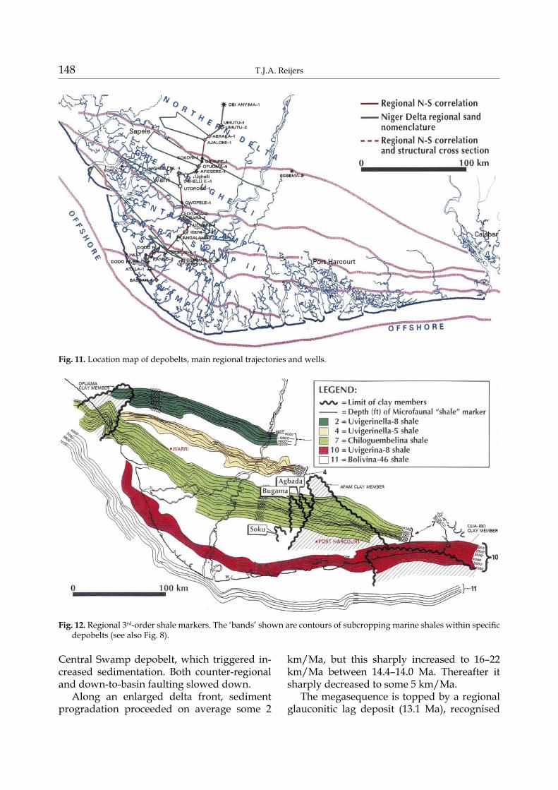
Fig. 11. Location map of depobelts, main regional trajectories and wells.
Fig. 12. Regional 3rd-order shale markers. The ‘bands’ shown are contours of subcropping marine shales within specific depobelts (see also Fig. 8).
Stratigraphy and sedimentology of the Niger Delta 149
in well cuttings and cores. It grades updip into lignites which seismically form a continuous high-amplitude reflection surface.
4.8. The Middle Miocene (12.8–11.5 Ma) Cassidulina-7 genetic megasequence
4.8.1. StratigraphyThe Cassidulina neocarinata (Cassidulina-7)
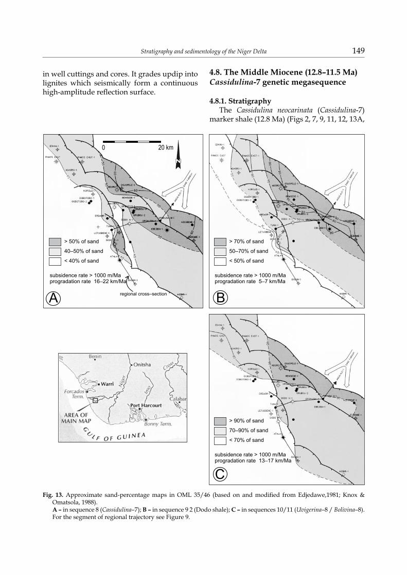
marker shale (12.8 Ma) (Figs 2, 7, 9, 11, 12, 13A,
Fig. 13. Approximate sand-percentage maps in OML 35/46 (based on and modified from Edjedawe,1981; Knox & Omatsola, 1988).A – in sequence 8 (Cassidulina–7); B – in sequence 9 2 (Dodo shale); C – in sequences 10/11 (Uvigerina–8 / Bolivina–8). For the segment of regional trajectory see Figure 9.
150 T.J.A. Reijers
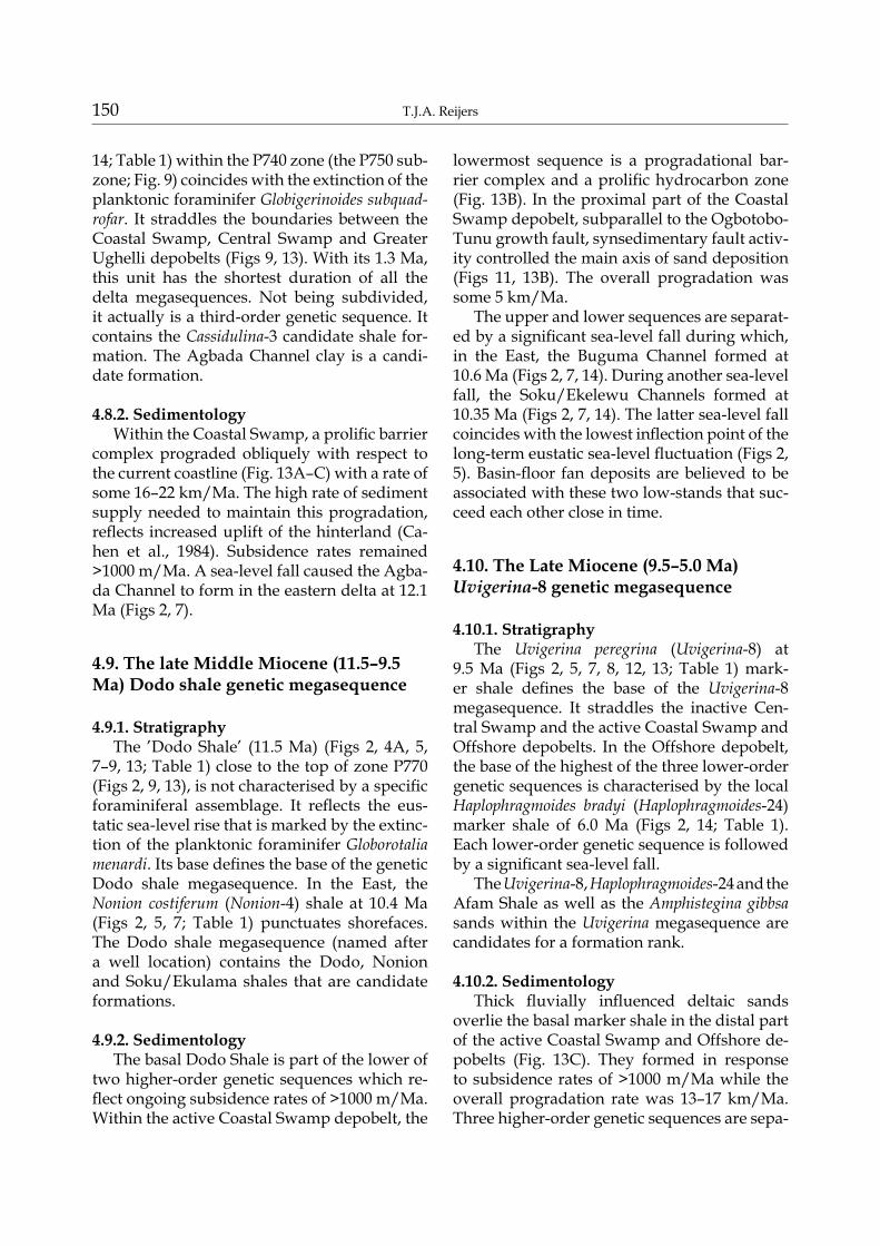
14; Table 1) within the P740 zone (the P750 sub-zone; Fig. 9) coincides with the extinction of the planktonic foraminifer Globigerinoides subquad-rofar. It straddles the boundaries between the Coastal Swamp, Central Swamp and Greater Ughelli depobelts (Figs 9, 13). With its 1.3 Ma, this unit has the shortest duration of all the delta megasequences. Not being subdivided, it actually is a third-order genetic sequence. It contains the Cassidulina-3 candidate shale for-mation. The Agbada Channel clay is a candi-date formation.
4.8.2. SedimentologyWithin the Coastal Swamp, a prolific barrier
complex prograded obliquely with respect to the current coastline (Fig. 13A–C) with a rate of some 16–22 km/Ma. The high rate of sediment supply needed to maintain this progradation, reflects increased uplift of the hinterland (Ca-hen et al., 1984). Subsidence rates remained >1000 m/Ma. A sea-level fall caused the Agba-da Channel to form in the eastern delta at 12.1 Ma (Figs 2, 7).
4.9. The late Middle Miocene (11.5–9.5 Ma) Dodo shale genetic megasequence
4.9.1. StratigraphyThe ’Dodo Shale’ (11.5 Ma) (Figs 2, 4A, 5,
7–9, 13; Table 1) close to the top of zone P770 (Figs 2, 9, 13), is not characterised by a specific foraminiferal assemblage. It reflects the eus-tatic sea-level rise that is marked by the extinc-tion of the planktonic foraminifer Globorotalia menardi. Its base defines the base of the genetic Dodo shale megasequence. In the East, the Nonion costiferum (Nonion-4) shale at 10.4 Ma (Figs 2, 5, 7; Table 1) punctuates shorefaces. The Dodo shale megasequence (named after a well location) contains the Dodo, Nonion and Soku/Ekulama shales that are candidate formations.
4.9.2. SedimentologyThe basal Dodo Shale is part of the lower of
two higher-order genetic sequences which re-flect ongoing subsidence rates of >1000 m/Ma. Within the active Coastal Swamp depobelt, the
lowermost sequence is a progradational bar-rier complex and a prolific hydrocarbon zone (Fig. 13B). In the proximal part of the Coastal Swamp depobelt, subparallel to the Ogbotobo-Tunu growth fault, synsedimentary fault activ-ity controlled the main axis of sand deposition (Figs 11, 13B). The overall progradation was some 5 km/Ma.
The upper and lower sequences are separat-ed by a significant sea-level fall during which, in the East, the Buguma Channel formed at 10.6 Ma (Figs 2, 7, 14). During another sea-level fall, the Soku/Ekelewu Channels formed at 10.35 Ma (Figs 2, 7, 14). The latter sea-level fall coincides with the lowest inflection point of the long-term eustatic sea-level fluctuation (Figs 2, 5). Basin-floor fan deposits are believed to be associated with these two low-stands that suc-ceed each other close in time.
4.10. The Late Miocene (9.5–5.0 Ma) Uvigerina-8 genetic megasequence
4.10.1. StratigraphyThe Uvigerina peregrina (Uvigerina-8) at
9.5 Ma (Figs 2, 5, 7, 8, 12, 13; Table 1) mark-er shale defines the base of the Uvigerina-8 megasequence. It straddles the inactive Cen-tral Swamp and the active Coastal Swamp and Offshore depobelts. In the Offshore depobelt, the base of the highest of the three lower-order genetic sequences is characterised by the local Haplophragmoides bradyi (Haplophragmoides-24) marker shale of 6.0 Ma (Figs 2, 14; Table 1). Each lower-order genetic sequence is followed by a significant sea-level fall.
The Uvigerina-8, Haplophragmoides-24 and the Afam Shale as well as the Amphistegina gibbsa sands within the Uvigerina megasequence are candidates for a formation rank.
4.10.2. SedimentologyThick fluvially influenced deltaic sands
overlie the basal marker shale in the distal part of the active Coastal Swamp and Offshore de-pobelts (Fig. 13C). They formed in response to subsidence rates of >1000 m/Ma while the overall progradation rate was 13–17 km/Ma. Three higher-order genetic sequences are sepa-
Stratigraphy and sedimentology of the Niger Delta 151
rated from each other by significant sea-level drops. In the eastern delta, erosive events at 8.5 Ma (Fig. 2) formed the salt-water embayment, the Afam Channel (Figs 4B, 7). It grades bas-inwards into a submarine canyon that incised sands that thus became part of a deep-water
setting (Knox & Omatsola, 1987; Jubril & Ama-jor, 1991).
The sequence is topped by a highly fos-siliferous (Amphistegina gibbosa) transgressive marker sand of 5.6 Ma (Fig. 2) that becomes disconformable landwards.
Fig. 14. Local 4th-order shale markers. The ‘bands’ shown are contours of subcrop-ping marine shales within specific de-pobelts (see also Fig. 8).
Fig. 15. Geomorphology, cyclic sedimentation and an active fault in the Tertiary Niger Delta coastal zone (modified after Weber, 1971).
152 T.J.A. Reijers
4.11. The Pliocene-Holocene (5.0-0.0 Ma) Bolivina-46 genetic megasequence
4.11.1. StratigraphyThe base of the Bolivina aenariensis (Bolivi-
na-46) shale defines the base of the Bolivina-46 megasequence (5.0 Ma) (Figs 2, 5, 7, 8, 12, 13C; Table 1). Locally unnamed higher-order trans-gressive claystone beds occur.
The Bolivina-46 megasequence contains the candidate Qua Iboe Formation, that has been subdivided by Mobil into the Biafra Sand, the Rubble Bed and the Qua Iboe Clay Members.
4.11.2. SedimentologySeismically the basal shale is a high-ampli-
tude event within a low-frequency transparent seismic facies (Fig. 9). Repeated severe sea-lev-el fluctuations gave rise to six higher-order ge-netic sequences that formed while subsidence rates were >1000 m/Ma. In the active offshore depobelt, 350–2,500 m thick wedge-shaped sed-imentary units reflect progradation of barrier complexes as fast as 14–17 km/Ma. Downdip, towards the offshore depobelt, these sediments grade into open–marine facies, and updip into fluviomarine and terrestrial facies (Fig. 13C). In the offshore depobelt, thicknesses of >3,500 m are common. The barrier complexes are locally punctuated by unnamed transgressive clay-stone beds. Hydrocarbons are mainly confined to delta-front sediments, but are also known from prodelta sands. In the easternmost delta, the Qua Iboe collapse – a result of volcanic ac-tivity in the Cameroon hinterland – took place at 3.0 Ma and the channel thus formed was filled by products of mass-transport processes, leaving a complex succession of lithological units.
5. Biostratigraphical framework
The stratigraphy of Niger Delta sections has traditionally been based on biochronological in-terpretations of fossil spores and foraminifers (Fig. 2). Palynological and foraminiferal bio-zones have proved to be reliable tools for large-scale correlations between wells. The delta-wide biostratigraphic framework and alphanumeric
codes used in the present contribution is based on biostratigraphic zonations established by the Shell Petroleum Development Company of Nigeria (SPDC) and calibrated with data from Elf (Durant, 1995 and pers. comm.). The Shell zonation was published by Evamy et al. (1978) and is used in Figures 3 and 4. This zonation allows correlation across all facies types from continental to marine. Currently, the Shell zo-nation contains 18 foraminiferal biozones and 7 sub-zones. Hierarchically, 9 partial range zones, 6 taxon zones, 2 assemblage zones and 1 concurrent range zone are included. Fifteen of these zones are based on index planktonic fo-raminifers recognised from transgressive ma-rine shales (Petters, 1983), while eight zones, previously unpublished, are based on ben-thonic foraminifers. The regionally persistent marine marker shales, as well as some of the more local shales (Fig. 5), have usually been named after one of the marker species and are coded systematically (Figs 2–4; Table 1).
Due to the world-wide distribution of the in-dex planktonic zones, and because the first and last appearance data of these taxa have been calibrated in millions of years (Ma), the Niger Delta foraminiferal zones have been correlated and integrated into the global geochronologi-cal and chronostratigraphical scheme of Har-land et al. (1990) (Fig. 2). This integration has made it easier to apply sequence stratigraphy to the Niger Delta succession with the help of the eustatic curves of Haq et al. (1988) (Fig. 2).
Attempts to mutually validate and integrate the SPDC framework of Evamy et al. (1978) with published and unpublished work of other in-dustry groups is hampered by the use of differ-ent numerical coding systems for the foraminif-eral systematics (Fig. 2). Petters (1982), however, presented a comprehensive atlas of taxonomic identifications of Niger-Delta foraminifers and their age and palaeoenvironmental interpreta-tions. Between 1995 and 1999, a Stratigraphic Committee of the Niger Delta aimed at mutu-ally validating and integrating the various bio-stratigraphic schemes. Some results are shown in Figure 2. As the ongoing work of the Strati-graphic Committee is not yet completed, the present contribution still refers to Evamy et al.’s (1978) alphanumeric coding system.
Stratigraphy and sedimentology of the Niger Delta 153
6. Genetic megasequences
Depositional sequences bounded above and below by unconformities of regional or local extent or their correlative conformities (Vail, 1987) are interpreted to represent the strati-graphic record of relative sea level changes re-sulting from significant changes of tectonic or eustatic regime while the delta grew. Internally such sequences are composed of allocyclic units including a maximum flooding surface (Fig. 6). Daily practice in the Niger Delta shows that erosion features on seismics and in well logs and cores cannot be traced delta-wide. They are usually confined to incised valleys or ’chan-nels’ at the flanks of the delta (examples are given by Orife & Avbovbo, 1981;Petters, 1984; Knox & Omatsola, 1987; see also Figs 2, 12, 14). Galloway’s (1989) genetic units between mfs’s, however, are extensively recognised in the Ni-ger Delta. The bounding shales of such units are therefore preferred for delta-wide correla-tion (Figs 12, 14).
From the Eocene onwards, the long-term eustatic sea-level curve (Fig. 5) shows a global sea-level drop. Together with the large sedi-ment supply from the hinterland, this caused delta progradation (Figs 3, 4). On the Haq et al. (1988) time scale (Table 1; Fig. 2), however, thirty-nine 3rd-order eustatic sea-level rises with associated maximum flooding surfaces (mfs) have been recognised worldwide, overprinting the lower-order overall sea-level drop.
The earliest Niger Delta sediments date from 54.6 Ma, and only nineteen significant mfs shale units have been recognised and dated in the Niger-Delta succession. They are labelled ’Base Marker Shales’ (BMS) in Figure 5 and they define 2nd-order megasequences. Most shales and overlying megasequences are named after a prominent faunal element. Eight shales are locally present, four of which are shown in Fig-ure 14. Eleven occur delta-wide and are trace-able across depobelt boundary faults, merging updip with continental deposits; five of them are shown in Figure 12. The bounding shales of the genetic megasequences are distinct seismic markers that facilitate mapping (Figs 12, 14) and regional correlation (Figs 8, 9). Such ge-netic units straddle Vail sequences (Figs 6, 7).
Such genetic units or megasequences are dia-grammatically shown in space in Figures 9 and 10, and in time in Figures 2 and 7. They will be discussed successively underneath.
7. Discussion of the cycles, sequences and depobelts
7.1. Cyclicity
The Niger Delta fill (Fig. 5) formed dur-ing 54.6 Ma, entirely within the Cenozoic Te-jas megacycle ’T’ (66.8 Ma-recent) originally defined by Sloss et al. (1949) and Sloss (1963). Subsequent work by the Exxon group and oth-ers broke up this megacycle into seven world-wide second-order supercycles (TA1, TA2, TA3, TA4 between 66.8 and 29.3 Ma, and TB1, TB2, TB3 between 29.3 Ma and today). These supercycles are shown in Figure 2 together with the eleven Niger Delta megasequences (Figs 5, 7) defined above. These eleven megasequences straddle supercycles TA2 and TB3. As stated in the ‘Methods’ section, the present contribu-tion differentiates between cycles (i. e. sea-level movements) and the way they are reflected in sequences (i.e. sediment packages).
Figure 2 shows the eleven Niger Delta megasequences that are the result from local al-locyclic ’drivers’ and global autocyclic process-es that ’drive’ the five-and-a-half global super-cycles. The Niger Delta genetic megasequences (Figs 6, 7) thus are hybrid: they simultaneously reflect global eustatic movements, local delta tectonics and allocyclic and autocyclic sedi-mentation processes.
The Haq et al. (1988) eustatic curve in Fig-ures 2 and 5 show two long-term cyclic oscilla-tions with durations of 41.8 Ma and 12.80 Ma, respectively. The first oscillation started with a maximum sea level at 54.6 Ma that is reflected in the Niger Delta in the basal shale of mega-sequence 1. It continues in a shallowing mode until a major (but not a maximum) deepening event took place, reflected in megasequence 4 at 29.3 Ma. It then deepened again and the next maximum sea level is reflected in the basal shale of megasequence 7 at 12.8 Ma. The falling limb of this oscillation spans part of supercycle TA2
154 T.J.A. Reijers
and the whole of supercycles TA3 and TA4, while the rising limb includes TB1 and part of TB2. The second long-term eustatic oscillation is reflected by the remainder of TB2 (partial) on the falling limb until the low-stand at 10.35 Ma; TB3 reflects the glacially influenced rising limb until the present (Fig. 5).
These long-term eustatic cycles affected the coastline at several stages of the evolution of the Niger Delta (Figs 3, 4). High-stands from long-term cycles coinciding with those from short-term cycles reinforced each other and triggered significant delta-wide floodings, whereas low-stands from long-term cycles, re-inforced by those from short-term cycles, gave rise to erosive events. In addition, the coast-line initially advanced slowly over a relatively short and straight front and an oceanward dip-ping basement, but from ~14 Ma ago prograda-tion speeded up and took place in pulses over a longer, lobate delta front and a landward dipping basement. Increased sediment supply from the rising Cameroon mountain range ac-celerated the progradation.
7.2. Sequences
Figure 2 shows how the Niger Delta mega-sequences formed over 2–7 Ma, averaging 4.96 Ma (Table 1). This markedly contrasts with the average of 10 Ma for the duration of a 2nd-order and of 1–3 Ma for a 3rd-order marine cycle as cited in literature (Miall, 1997). Therefore it is thought that the Niger Delta megasequences are composed of third- and possibly higher-order genetic sequences superimposed on each other while forming depobelts as follows (see also Figs 3, 4, 5, 7–10, 13; Table 1):(1) Northern depobelt: 4 megasequences with
18 3rd-order sequences formed over 28.4 Ma;
(2) Ughelli depobelt: 2 megasequences with 7 3rd-order sequences formed over 10.3 Ma;
(3) Central Swamp: 2 megasequences with 3 3rd-order sequences formed over 4.4 Ma;
(4) Coastal Swamp: 2 megasequences with 5 3rd-order sequences formed over 6.5 Ma;
(5) Offshore depobelt: 1 megasequence with 6 3rd-order sequences formed over 5.0 Ma.
This shows that (mega)sequences in the young delta formed depobelts with a higher resolution and progradation rate in less time than in the old delta. This results from the ef-fects of high-order eustatic cyclicity and of delta tectonics with various periodicities, com-bined with the effects of the rising and falling limbs and of the inflection points of 2nd-order supercycles. Thus eleven Niger Delta mega-sequences originated that took, on average, 4.96 Ma to form and that are composed of 3rd-order sequences that formed, on average, over periods of 1.37 Ma (Figs 5, 7–9; Table 1).
Mitchum & Van Wagoner (1990, 1991) ad-dressed the role of sediment-supply rates and accommodation space that led to the formation of 4th-order sequences, or “sequence-sets that represent the systems tracts of 3rd-order com-posite sequences” in the Eocene Gulf of Mexico. Brink et al. (1993) carried out a similar study for the Cretaceous Pletmos Basin in South Africa. Results of these studies can be used to explain the internal architecture of megasequences in the Niger Delta (Fig. 6) that reflect 3rd-order eustatic cycles superimposed on the rising and falling limbs of 2nd-order supercycles.
The effects of either sea-level falls of 3rd-order eustatic cycles or of short-lived uplifts (relative sea-level falls) due to delta tectonics, or of both, are reinforced if in phase with the falling limb of 2nd-order eustatic supercycles and may result in erosional features or unconformities. Typically, such unconformities are confined to the flanks of the delta. This is illustrated by the distribu-tion of ’channels’ (Figs 7, 12, 14) of which the or-igin can be linked with compressive intraplate stresses during the growth of the delta that pro-duce short-lived uplift (relative sea-level fall) and with associated localised unconformities in the flanks of the basin (Cloeting et al., 1985). Downdip channel fills are commonly associated with time-equivalent gravity deposits.
Likewise, sea-level rises of 3rd-order eustatic cycles are reinforced if in phase with the ris-ing limb of a 2nd-order eustatic supercycle and additional accommodation space is created. During flooding, transgressive shales and lag deposits formed (Figs 8, 9, 14) and earlier ero-sional features became filled with clays, sands and heteroliths (Fig. 11).
Stratigraphy and sedimentology of the Niger Delta 155
High-periodicity sea-level movements that are out of phase with long-period cyclicity sub-dued the erosional or the flooding features. The Opuama Channel in the western Niger Delta shows ample evidence of this feature as it un-derwent several phases of incision and filling, resulting in a set of nested channels that reflect high- and low-periodicity cycles that interfered with each other (Knox & Omatsola, 1989).
During the 2nd-order long-term fall of the eustatic curve, megasequences 1–4 (Fig. 2) formed in the active but embryonic and fluvial-ly dominated northern delta. The coastline re-mained more or less stationary. At the junction between supercycles TA4 and TB1, around the long-term eustatic low-inflection point (at 29.3 Ma), cutting and filling of the Opuama Chan-nel started in the western delta. Subsequent high-period sea-level fluctuations on the rising limb of the curve triggered the formation of megasequences 4 (partially) through 7, with al-ternating erosion and fill of the Opuama Chan-nel. In megasequence 5, delta-lobe switching in the Greater Ughelli and the Central Swamp depobelts triggered pulses of delta prograda-tion (<8–15 km/Ma) but during formation of megasequence 6 in the southern Ughelli and the northern Central Swamp depobelts, pro-gradation rates fell off to some 2 km/Ma.
7.3. Depobelts
The long-term eustatic sea-level high-stand inflexion point at 13.1 Ma marks cycle TB2.4 and coincides with active deposition in the Central Swamp depobelt. Delta progradation speeded up to 16–22 km/Ma and the delta front enlarged. Simultaneously, movements along growth faults increased (Fig. 13). Cycles TB2.5–6 on the falling limb of the curve triggered the formation of megasequences 7–9 (Fig. 2). Dep-osition shifted to the Coastal Swamp depo-belt. The high-stand inflection point at 13.1 Ma marks a switch from delta aggradation to pro-gradation over oceanic basement (Fig. 9) on the falling limb of the curve. This limb coincides with a sea-level low-stand at 12.1 Ma when, in the eastern delta, the Agbada Channel was in-cised in the Coastal Swamp depobelt. During
formation of megasequence 9, delta prograda-tion alternated between a rapid rate of 16–22 km/Ma and a more steady rate of 5 km/Ma. The Coastal Swamp was marked by erosion through two successive major sea-level falls at 10.6 and 10.35 Ma, resulting in the formation of the Buguma and the Soku/Ekelewu Chan-nels. A period of increased delta subsidence (>1000 m/Ma) and progradation (13–17 km/Ma) stopped the formation of megasequence 9. In megasequence 10, in the Coastal Swamp and Offshore depobelts, a high-period sea-lev-el fall, superimposed on the rising limb of the long-term eustatic curve, triggered erosion of the Afam Channel (8.5 Ma).Thereafter, the hin-terland shredded extensive amounts of clastic sediment, triggering pulses of delta prograda-tion of 14–17 km/Ma (Fig. 13). On the rising eustatic curve, a transgressive clay marks the base of megasequence 11 at 5.0 Ma (Figs 2, 5, 7, 9). The Offshore depobelt formed and the Qua Iboe collapse took place at 3.0 Ma. The upper part of genetic megasequence 11, including the present-day delta surface, was strongly influ-enced by glacially induced eustacy.
8. Lithostratigraphy
In a cartoon-like cross-section, approxi-mately NE-SW and parallel to the regional N-S correlation line shown in Figures 9 and 11, the eleven genetic megasequences have roughly a sinusoidal shape, broadly reflecting the pro-file of the delta (Figs 6–7) that incrementally built out through time (Fig. 2). Each mega-sequence is internally organised similarly, as pictured in the sedimentation model of Figures 6 and 15. Within each of the units, the sandiest developments are growth-fault-controlled Ag-bada lithofacies (Figs 13, 15) while basinwards thin synchronous toe-set deposits grade into the Akata sediments. Landwards, top-set de-posits grade into the Benin sediments. As the eleven megasequences get younger, the Benin, Agbada and Akata lithofacies cross time lines (Fig. 9). Lateral linkage of these lithofacies turns them into the diachronous Benin, Agbada and Akata units, traditionally at formation level. A different lithostratigraphic approach is sug-
156 T.J.A. Reijers
gested in the present contribution, for which it is proposed that these three lithological units are elevated to group level.
The sigmoidal composite lithological units or megasequences (Fig. 7) are the primary sub-divisions of the sedimentary record on a time base. Each megasequence includes a ‘segment’ of the Benin, the Agbada and the Akata For-mations and these ’segments’, joined across the megasequence boundaries, should become the Benin, Agbada and Akata Groups. Thus, the Akata Group is composed of eleven ’Akata seg-ments’; each one reflecting one of the megase-quences. The autocyclic growth phases within the various Agbada segments result in vari-ous lithologies that can be further subdivided, fully in accordance with the rules of the North American Stratigraphic Code (1983), into for-mations and members if and when needed. In the preceding text several suggestions have been made for new lithostratigraphic units.
Obvious candidates, up till now mainly shales, have been referred to in the preced-ing discussion. More candidates, particularly sands, will have to be defined in the future as a result of ongoing work, and the Niger Delta Stratigraphic Committee is the first body that
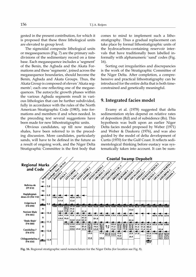
comes to mind to implement such a litho-stratigraphy. Thus a gradual replacement can take place by formal lithostratigraphic units of the hydrocarbons-containing reservoir inter-vals that have traditionally been labelled in-formally with alphanumeric ’sand’ codes (Fig. 16).
Sorting out irregularities and discrepancies is the work of the Stratigraphic Committee of the Niger Delta. After completion, a compre-hensive and practical lithostratigraphy can be introduced for the entire delta that is both time-constrained and genetically meaningful.
9. Integrated facies model
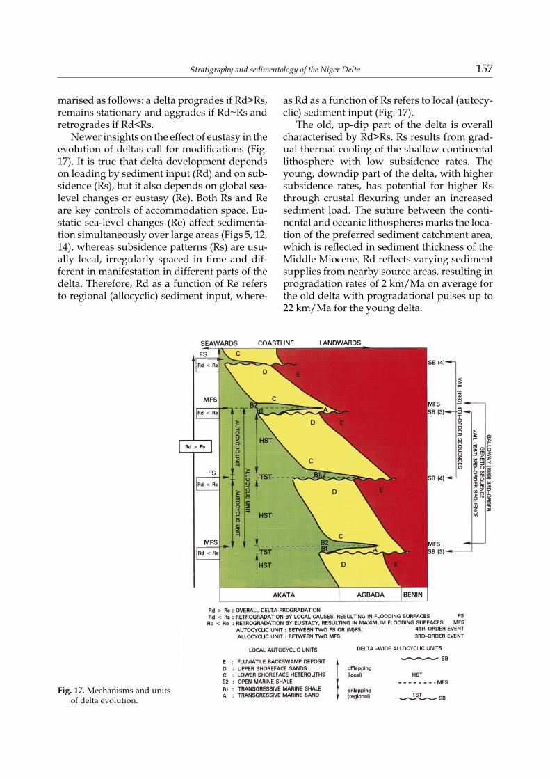
Evamy et al. (1978) suggested that delta sedimentation styles depend on relative rates of deposition (Rd) and of subsidence (Rs). This hypothesis was built upon an earlier Niger Delta facies model proposed by Weber (1971) and Weber & Daukoru (1976), and was also guided by the model of delta development of Curtis (1970) for the Gulf Coast. It reflects sedi-mentological thinking before eustacy was sys-tematically taken into account. It can be sum-
Fig. 16. Regional stratigraphic sand nomenclature for the Niger Delta (for location see Fig. 8).
Stratigraphy and sedimentology of the Niger Delta 157
marised as follows: a delta progrades if Rd>Rs, remains stationary and aggrades if Rd~Rs and retrogrades if Rd<Rs.
Newer insights on the effect of eustasy in the evolution of deltas call for modifications (Fig. 17). It is true that delta development depends on loading by sediment input (Rd) and on sub-sidence (Rs), but it also depends on global sea-level changes or eustasy (Re). Both Rs and Re are key controls of accommodation space. Eu-static sea-level changes (Re) affect sedimenta-tion simultaneously over large areas (Figs 5, 12, 14), whereas subsidence patterns (Rs) are usu-ally local, irregularly spaced in time and dif-ferent in manifestation in different parts of the delta. Therefore, Rd as a function of Re refers to regional (allocyclic) sediment input, where-
as Rd as a function of Rs refers to local (autocy-clic) sediment input (Fig. 17).
The old, up-dip part of the delta is overall characterised by Rd>Rs. Rs results from grad-ual thermal cooling of the shallow continental lithosphere with low subsidence rates. The young, downdip part of the delta, with higher subsidence rates, has potential for higher Rs through crustal flexuring under an increased sediment load. The suture between the conti-nental and oceanic lithospheres marks the loca-tion of the preferred sediment catchment area, which is reflected in sediment thickness of the Middle Miocene. Rd reflects varying sediment supplies from nearby source areas, resulting in progradation rates of 2 km/Ma on average for the old delta with progradational pulses up to 22 km/Ma for the young delta.
Fig. 17. Mechanisms and units of delta evolution.
158 T.J.A. Reijers
Under conditions of Rd>Rs, the delta pro-grades and regressive, offlapping sands are deposited over uncompacted clays with low shear strength. This triggers counter-regional and down-to-basin faults. Under conditions of Rd~Rs, and as long as counter-regional faults prevent progradation of the barrier facies com-plex, the delta aggrades (Figs 10, 13). How-ever, once the barrier facies complex crosses the counter-regional fault, progradation starts again in a newly activated depobelt. Under conditions of Rd<Rs, retrogradational breaks and short-lived transgressions occur in the overall prograding/aggrading delta. Local im-balances in Rd are related to delta-lobe switch-ing, whereas variations in Rs reflect tectonic activity in various megastructures of the delta. Therefore imbalances in Rd and Rs may result in retrogradational breaks within specific sec-tions of the delta only. By contrast, Rd<Re re-flects eustatic sea-level changes that result in transgressive events, usually affecting major parts of the delta (Figs 2, 5, 12, 14, 18; Table 1).
Delta-front sedimentation patterns are schematically depicted in Figure 15, a modi-fied Weber (1971) facies model that includes
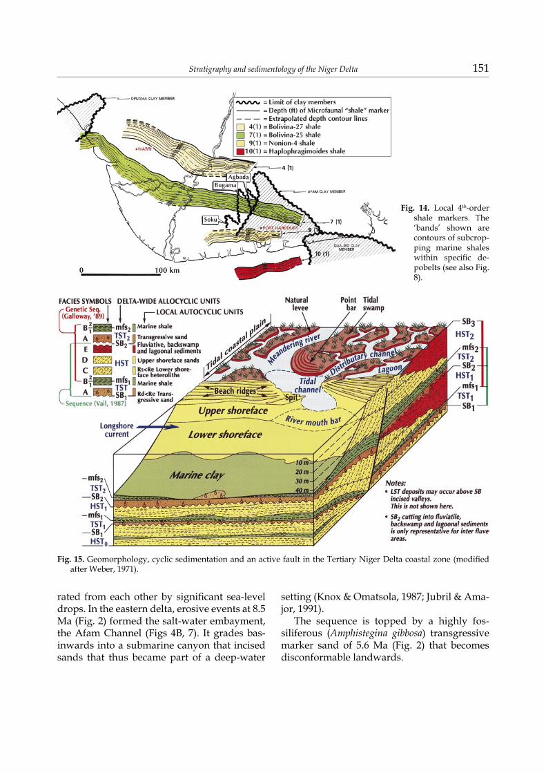
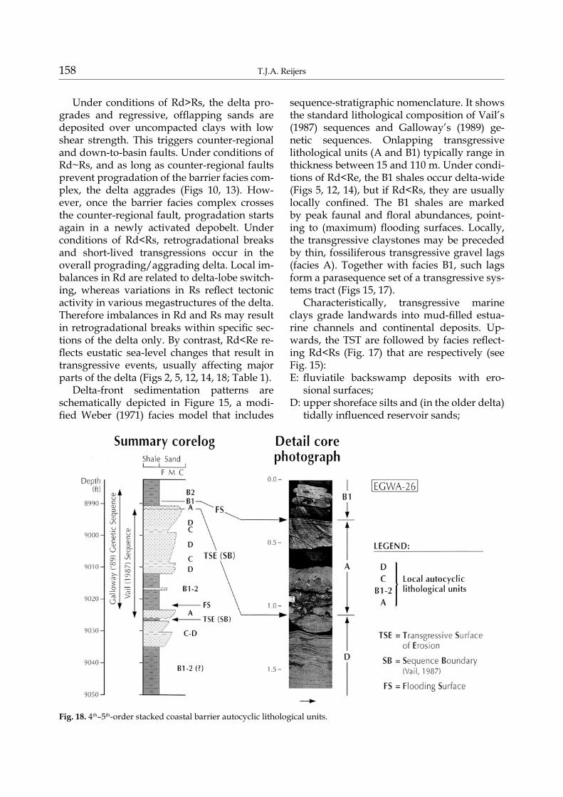
sequence-stratigraphic nomenclature. It shows the standard lithological composition of Vail’s (1987) sequences and Galloway’s (1989) ge-netic sequences. Onlapping transgressive lithological units (A and B1) typically range in thickness between 15 and 110 m. Under condi-tions of Rd<Re, the B1 shales occur delta-wide (Figs 5, 12, 14), but if Rd<Rs, they are usually locally confined. The B1 shales are marked by peak faunal and floral abundances, point-ing to (maximum) flooding surfaces. Locally, the transgressive claystones may be preceded by thin, fossiliferous transgressive gravel lags (facies A). Together with facies B1, such lags form a parasequence set of a transgressive sys-tems tract (Figs 15, 17).
Characteristically, transgressive marine clays grade landwards into mud-filled estua-rine channels and continental deposits. Up-wards, the TST are followed by facies reflect-ing Rd<Rs (Fig. 17) that are respectively (see Fig. 15): E: fluviatile backswamp deposits with ero-
sional surfaces;D: upper shoreface silts and (in the older delta)
tidally influenced reservoir sands;
Fig. 18. 4th–5th-order stacked coastal barrier autocyclic lithological units.
Stratigraphy and sedimentology of the Niger Delta 159
C: lower shoreface heteroliths;B2: open-marine shales and sands with neritic
delta-fringe faunal elements. Some of these facies units are seen in cores of well Egwa-26 (Fig. 17). Units B2, C, D, E together form offlapping
parasequence sets in a high-stand systems tract. The parasequence sets of the systems tracts re-flect changes in accommodation space by eu-static movements of different periods and by differential subsidence. Most high-stand (HST) lithologies are autocyclic offlapping parase-quences, directly responding to local subsid-ence patterns, whereas the transgressive (TST) sands and the delta-wide shales defining the megasequences are regional allocyclic onlap-ping parasequence sets responding to eustatic fluctuations. A typical Niger Delta genetic se-quence contains a HST-TST couplet. In mega-sequences 5 and 9, some low-stands (LST) are recorded in association with erosional features updip. Because erosional features are also present in megasequences 1, 6, 7, 8 and 10, mass-transport deposits in LST’s are expected downdip. The discrete time interval between successive maximum (= delta-wide) flooding
surfaces reflects periods during which the del-ta incrementally prograded. In the Niger Delta, the eleven megasequences, from the base of each of the delta-wide transgressive shales to the base of the next one, are used as the basic units to subdivide the delta succession.
Internally the parasequence sets may be variable, as is shown by a delta lobe advanc-ing towards a curved or oblique down-to-basin fault that extends upwards to the sea bottom (Figs 10, 13, 15). Such a delta-lobe movement triggers rotation of the hanging wall and as-sociated subsidence at the sea bottom, which increases the accommodation space and trig-gers autocyclic processes. Sedimentation takes place and excess sediments (Rd>Rs) spill over the shelf edge. On an irregular shelf slope, they could accumulate in local depocentres while remaining attached to the shelf sands. By con-trast, spilled sands bypassing a smooth slope may accumulate as turbidites and other mass-transport deposits on the basin floor and are usually detached from the shelf sands. The formation of such attached or detached deep-er marine ’spill-over’ sands in the delta front zone typically took place when the younger
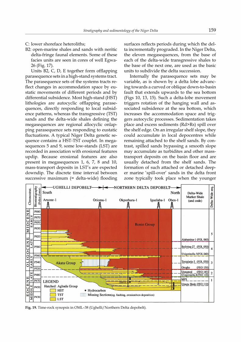
Fig. 19. Time-rock synopsis in OML–38 (Ughelli/Northern Delta depobelt).
160 T.J.A. Reijers
delta was formed. There may be a relationship between abundant sediment supply from the hinterland, pulsating delta progradation and significant sea-level falls resulting in updip incising channels. Further study is needed to confirm this hypothesis.
Over the years, subsurface mapping has clarified the progradational nature of the con-tinental Benin and the coastal to shallow ma-rine Agbada units. The mechanism that drives this process has been referred to as ’escalator regression’ (Knox & Omatsola, 1988) and this model now dominates the ideas on the strati-graphic evolution of the Niger Delta. The ’steps’ in this model are the formation of the depobelts, reflecting phases of structural delta evolution (Figs 3, 4). Fast and slow prograda-tion alternate, regulated by available sediment, the nature of the basement, its subsidence and synsedimentary faulting styles. Accumulation of sandy sediments over mobile claystones triggers growth faulting, which concentrates sands in certain areas (Fig. 13). This, in turn, triggers further loading. Ongoing synsedimen-tary activity along counter-regional faults con-trols progradation of shallow-marine sand/shale couplets of the Agbada unit during outbuilding of the delta (Fig. 13). Decreasing movement along such counter-regional faults and increased sediment supply (Rd>>Rs) al-lows Agbada barrier complexes to cross coun-ter-regional faults (Fig. 10). The distal Agbada parasequences (the B2 lithologies) merge bas-inward with the Akata. Simultaneously, the al-luvial continental Benin sands advance across the older depobelt. Thus the base level is main-tained in the old depobelt, and deposition be-comes transferred to the new one. Eventually this process yielded the strongly diachronous Agbada and Benin sediments (Figs 2, 6, 9, 17, 19).
10. Conclusions
The publication of this renewed focus on the sedimentology and stratigraphy of the Niger Delta offers, though unfortunately somewhat delayed, the building stone for the introduction of an up-to-date practical stratigraphic frame-
work. The improved tie of biozones to the ra-diometric time-scale considerably improved the accuracy of detailed stratigraphic analyses, and increasingly more well sections are avail-able that can be interpreted in this way. Thirty-nine eustatic sea-level rises are reflected in the Niger Delta, nineteen of which are named and eleven of which occur delta-wide. These pro-duced sinusoidal sediment bodies or genetic megasequences that are marked at the base by delta-wide transgressive shales. They are the key lithological elements of the Niger Delta and the starting point for a new delta-wide litho-stratigraphy. The genetic megasequences are interpreted to reflect allocyclic events super-imposed on which occur a series of autocyclic events. A modified facies model reflects del-taic sedimentation patterns as a function of the rates of deposition, subsidence and eustacy. It explains and predicts sediment patterns within a series of third-order genetic sequences, com-posed of genetic parasequence sets. At several levels, pronounced seismic horizons reveal rel-ics of incised valleys which are the Niger Delta ’channels’. They reflect favourable erosional conditions at the combined 2nd-and 3rd-order levels of eustatic sea-level fluctuations and are associated with mass-transport deposits in a downdip position.
AcknowledgementsI acknowledge permission of the Department of
Petroleum Resources of the Ministry of Petroleum Resources, Nigeria, of SPDC and their joint-venture partners, Nigerian National Petroleum Company (NNPC), Elf and Agip, as well as of the Depart-ment of Petroleum Resources of the Ministry of Petroleum Resources, Nigeria, to present parts of this contribution at the 1997 AAPG Conference in Vienna and the 1997 NAPE Conference in Lagos, and to publish these parts as the present delayed integrated contribution. Information published ear-lier by Elf (Durand,1995) was also used. I acknowl-edge the helpful personal communication with my colleagues Ojoh (1997), Nwajide and Adesida (1996–1999) and the permission to use a number of unpublished reports while working on a unified ap-proach to the stratigraphy of the Niger Delta within the Stratigraphic Committee of the Niger Delta. I also thank Prof. Dr H. Doust and an unknown re-
Stratigraphy and sedimentology of the Niger Delta 161
viewer for their suggestions for improvement. The contributions by all these co-workers and friends are gratefully acknowledged.
References Berggren, W.A. & Hollister, C.D.,1974. Paleogeography,
paleobiogeography and the history of the circulation in the Atlantic Ocean. [In:] W.W. Hay (Ed.): Studies in paleo-oceanography. SEPM Special Publication 20, 126–185.
Brink, G.J., Keenan, J.H.G. & Brown Jr., L.F., 1993. Deposi-tion of fourth-order, post-rift sequences and sequence sets, Lower Cretaceous (Lower Valanginian to Lower Aptian, Pletmos Basin, Southern offshore, South Af-rica. [In:] P. Weimer & H.W. Posamentier (Eds): Sil-iciclastic sequence stratigraphy. AAPG Memoir 58, 492 pp.
Burke, K., 1972. Longshore drift, submarine canyons and submarine fans in Development of Niger Delta. American Association of Petroleum Geologists Bulletin 56, 1975–1983.
Cahen, L.N.J. Snelling, Delhal, T. & Vail, J.R., 1984. The geochronology and evolution of Africa. Oxford Science, London.
Cloeting, S., McQueen, H. & Lambeck, K.,1985. On a tec-tonic mechanism for regional sea-level variations. Earth and Planetary Science Letters 75, 157–166.
Curtis, D.M., 1970. Miocene deltaic sedimentation, Loui-siana Gulf Coast. [In:] J.P. Morgan (Ed.): Deltaic sedi-mentation – modern and ancient. SEPM Special Publica-tion 15, 293–308.
Durand, J., 1995. High resolution sequence stratigraphy (genetic stratigraphy) in reservoir sedimentology: ex-amples from the Niger Delta. Nigerian Association of Petroleum Explorationists Bulletin 10, 65–73.
Ejedawe, J.E., 1981. Patterns of incidence of oil reserves in Niger Delta Basin. American Associatioin of Petroleum Geologists Bulletin 65, 1574–1585.
Ejedawe, J.E. , Coker, S.J.L., Lambeth-Aikhionabare, D.O., Alofe, K.B. & Adoh, E.O., 1984. Evolution of oil-gener-ative window and oil and gas occurrence in Tertiary Niger Delta Basin. American Association of Petroleum Geologists Bulletin 68, 1744–1751.
Evamy, D.D.J., Haremboure, P., Kamerling, W.A., Knaap, F.Molloy, A. & Rowlands, M.H., 1978. Hydrocarbon habitat of the Tertiary Niger Delta. American Associa-tion of Petroleum Geologists Bulletin 62, 1–39.
Galloway, W.E., 1989. Genetic stratigraphic sequences in basin analysis 1: Architecture and genesis of flooding-surface bounded depositional units. American Associa-tion of Petroleum Geologists Bulletin 73, 125–142.
Harland, W.B., Armstrong, R.L., Cox, A.V., Craig, L.E., Smith, A.G. & Smith, D.G., 1990. A geological time scale 1989. Cambridge University Press, Cambridge, 263 pp.
Haq, B.U., Hardenbol, J. & Vail, P.R., 1988. Mesozoic and Cenozoic chronostratigraphy and cycles of sea level changes. [In:] C.K. Wilgus, B.S. Hastings, H. Posa-
mentier, J. van Wagoner, C.A. Ross & C.G.S.C. Ken-dall (Eds): Sea-level changes – an integrated approach. SEPM Special Publication 42, 71–108.
Jubril, M.A. & Amajor, L.C., 1991. The Afam Clay Mem-ber: a Lower Miocene incised channel in the south-eastern Niger Delta. Marine and Petroleum Geology 8, 163–173.
Knox, G.J. & Omatsola, M.E., 1987. Development of the Cenozoic Niger Delta in terms of the escalator regres-sion model. [In:] Proceedings of the KNGMG Symposium ‘Coastal Lowlands – Geology and Geotechnology’. Kluwer Academic Publishers, 181–202.
Ladipo, K.O.1992. Sequence stratigraphic analysis: an example of applications to prospect appraisal in the Northern (western) Niger Delta, Nigeria. Nigerian Association of Petroleum Explorationists Bulletin 7, 153–158.
Magbagbeoloa, O. & Willis, B.J., 2007. Sequence stratigra-Sequence stratigra-phy and syndepositional deformation of the Agbada Formation, Robertkiri field, Niger Delta, Nigeria. American Association of Petroleum Geologists Bulletin 91, 945–958.
Miall, A.D., 1997. The geology of stratigraphic sequences. Springer, Berlin, 433 pp.
Mitchum Jr., R.M. & Van Wagoner, J.C., 1990. High-fre-quency sequences and eustatic cycles in the Gulf of Mexico Basin. [In:] J.M. Armentrout & B.F. Perkings (Eds): Sequence stratigraphy as an exploration tool-concepts and practices in the Gulf Coast. Gulf Coast Section, SEPM, Program and Abstracts Eleventh Annual Research Conference, Houston, p. 257–267.
Mitchum Jr., R.M. & Van Wagoner, J.C., 1991. High frequency sequences and their stacking patterns: sequence-stratigraphic evidence of high-frequency eustatic cycles. Sedimentary Geology 70, 131–160.
North American Commission on Stratigraphic Nomen-clature, 1983. North American Stratigraphic Code. American Association of Petroleum Geologists Bulletin 67, 841–875.
Orife J.M. & Afbovbo, A.A.,1981. Stratigraphic and uncon-formity traps in the Niger delta – Abstract. American Association of Petroleum Geologists Bulletin, 251–265.
Owoyemi, A.O. & Willis, BJ., 2006. Depositional patterns across syndepositional normal faults, Niger delta, Ni-geria. Journal of Sedimentary Research 76, 346–363.
Petters, S.W., 1982. Central West African Cretaceous-Ter-tiary benthic foraminifera and stratigraphy: Palaeonto-graphia A 179, 1–104.
Petters, S.W., 1983. Gulf of Guinea planktonic foraminife-ral biochronology and geological history of the South Atlantic. Journal of Foraminiferal Research 13, 32–59.
Petters, S.W., 1984. An ancient submarine canyon in the Oligocene-Miocene of the western Niger Delta. Sedi-mentology 31, 805–810.
Reijers, T.J.A., Petters, S.W. & Nwajide, C.S., 1997. The Niger Delta Basin. [In:] R.C. Selley (Ed.): African ba-sins. Sedimentary Basins of the World (Elsevier, Am-sterdam) 3, 145–168.
Short, K.C. & Stauble, A.J., 1967. Outline geology of the Niger Delta. American Association of Petroleum Geolo-gists Bulletin 51, 761–779.

162 T.J.A. Reijers
Sloss, L.L., 1963. Sequences in the cratonic interior of North America. Geological Society of America Bulletin 74, 93–113.
Sloss, L.L., Krumbein, W.C. & Dapples, E.C., 1949. Inte-grated facies analysis. [In:] C.R. Longwel (Ed.): Sedi-mentary facies in geologic history. Geological Society of America Memoir 39, 181–191.
Stacher, P., 1995. Present understanding of the Niger Del-ta hydrocarbon habitat. [In:] M.N. Oti & G. Postma (Eds): Geology of deltas. Balkema, Rotterdam, 257–268.
Vail, P.R., 1987. Seismic stratigraphy interpretation, us-ing sequence stratigraphy. Part I: Seismic stratigraph-
ic procedure. [In:] A.W. Balley (Ed.): Atlas of seismic stratigraphy 1. American Association of Petroleum Ge-ologists Studies in Geology 27, 1–10.
Weber, K.J., 1971. Sedimentological aspects of oil fields in the Niger Delta. Geologie en Mijnbouw 50, 559–576.
Weber, K.J. & Daukoru, E., 1975. Petroleum geology of the Niger Delta. Proceedings of the Ninth World Pe-Proceedings of the Ninth World Pe-troleum Congress 2, 209–221.
Manuscript received: 5 May 2011 Revision accepted: 10 June 2011