AutoCAD Civil 3D Hydraflow Hydrographs Extension - User's Guide

Storm Water Management
Calculations
Project:
BATH SENIOR LIFESTYLE CARE FACILITY Township of Bath
Summit County, Ohio
Prepared By:
TGC Engineering 1310 Sharon Copley Road
Sharon Center, Ohio 44274
Christopher M. Schmidt, PE
November 16, 2017

Table of Contents
Project Description ......................................................................................................................................... 3 Stormwater Detention Design Methodology ................................................................................................ 3 Hydrologic Soil Group ................................................................................................................................... 3 Stormwater Management Design .................................................................................................................. 3 Critical Storm Calculation .............................................................................................................................. 4 Appendices ..................................................................................................................................................... 5 Figures ............................................................................................................................................................. 5

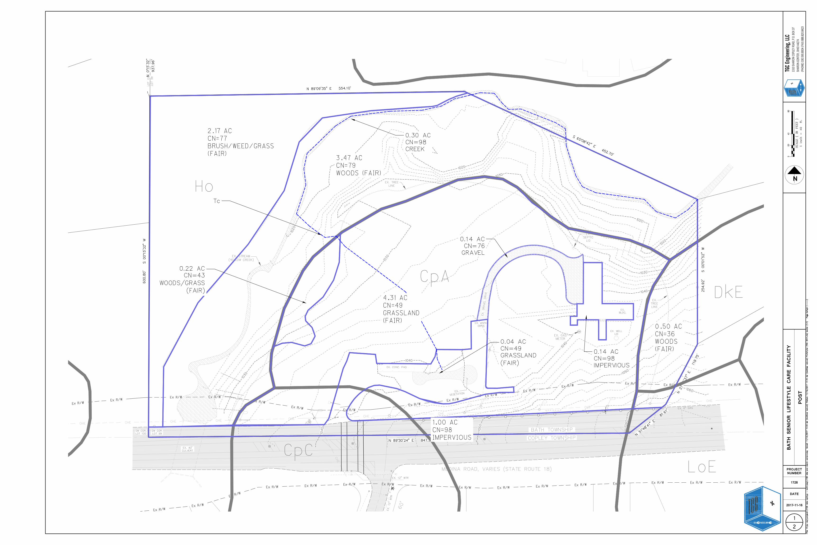
Project Description
Bath Senior Lifestyle Care Facility is a commercial project including a paved parking lot, storm sewer, sanitary sewer, water main, & water quality/quantity control basins. Stormwater Detention Design Methodology
Summit County Engineer requirements were used to evaluate the present and developed storm water run-off.
The data was collected via site visits, aerial photos, field surveys, and UDSA soils maps.
The data was processed and analyzed using Hydraflow Hydrographs 2016 computer software. The TR-55 method was used to develop the hydrographs.
Hydrologic Soil Group The site contains the following soil type & hydrologic group classification:
CpA A
CpC A
DkE A
Ho D Stormwater Management Design There is a primary stormwater management pond for on-site detention. When the primary stormwater management pond becomes full the excess will discharge into a secondary dry detention basin located on the west side of the property. There is also a third stormwater management pond available to serve as a drainage collection point for the northwest area of the site. Utilizing all three of these ponds all stormwater management requirements will be met or exceeded.

Critical Storm Calculation The critical storm for the watershed is as follows:
The one-year storm was used for this calculation.
VOLUME
AREA PRE POST % CHANGE
CALCULATED CRITICAL STORM
Critical
8,158
13,700
68%
10

Appendices
Appendix A – 1 YR Pre & Post Hydrographs Appendix B – CN & Tc calculations Figures Hydrology: Pre-Development 1/2 Hydrology: Post-Development 2/2

Appendix A – 1 YR Pre & Post Hydrographs

Hydrograph Report
Hydraflow Hydrographs Extension for AutoCAD® Civil 3D® 2016 by Autodesk, Inc. v11 Thursday, 11 / 16 / 2017
Hyd. No. 1
PRE
Hydrograph type = SCS Runoff Peak discharge = 1.103 cfsStorm frequency = 1 yrs Time to peak = 732 minTime interval = 1 min Hyd. volume = 8,158 cuftDrainage area = 12.290 ac Curve number = 68Basin Slope = 0.0 % Hydraulic length = 0 ftTc method = TR55 Time of conc. (Tc) = 23.00 minTotal precip. = 1.97 in Distribution = Type IIStorm duration = 24 hrs Shape factor = 484
1
0 120 240 360 480 600 720 840 960 1080 1200 1320 1440 1560
Q (cfs)
0.00 0.00
1.00 1.00
2.00 2.00
Q (cfs)
Time (min)
PRE
Hyd. No. 1 -- 1 Year
Hyd No. 1

Hydrograph Report
Hydraflow Hydrographs Extension for AutoCAD® Civil 3D® 2016 by Autodesk, Inc. v11 Thursday, 11 / 16 / 2017
Hyd. No. 2
POST
Hydrograph type = SCS Runoff Peak discharge = 2.677 cfsStorm frequency = 1 yrs Time to peak = 731 minTime interval = 1 min Hyd. volume = 13,700 cuftDrainage area = 12.290 ac Curve number = 73Basin Slope = 0.0 % Hydraulic length = 0 ftTc method = TR55 Time of conc. (Tc) = 25.30 minTotal precip. = 1.97 in Distribution = Type IIStorm duration = 24 hrs Shape factor = 484
3
0 120 240 360 480 600 720 840 960 1080 1200 1320 1440 1560
Q (cfs)
0.00 0.00
1.00 1.00
2.00 2.00
3.00 3.00
Q (cfs)
Time (min)
POST
Hyd. No. 2 -- 1 Year
Hyd No. 2

Appendix B – CN & Tc Calculations
Area
98 1.14 111.72
76 0.14 10.64
PASTURE, GRASSLAND, OR RANGE (FAIR) 49 4.35 213.15
WOODS/GRASS COMBINATION (FAIR) 43 0.22 9.46
WOODS (FAIR) 36 0.50 18.00
CREEK 98 0.30 29.40
79 3.47 274.13
77 2.17 167.09
Totals 12.29 833.59
Total Product 833.59
Total Area 12.29
Worksheet 2: Runoff curve number and runoff
Project: BATH SENIOR LIFESTYLE CARE
FACILITY
By: MRD 11/15/2017 PRE
Location: BATH TOWNSHIP, SUMMIT
COUNTY
Checked:
Check one:
1. Runoff curve number
Soil name and hydrologic
group (appendix A)
Cover description CN1/ Product of CN x area(cover type, treatment, and hydrologic condition; percent impervious;
unconnected/connected impervious area ratio)
Ta
ble
2-2
Fig
ure
2-3
Fig
ure
2-4
A IMPERVIOUS
CpA-A GRAVEL DRIVE
CpA-A
CpA-A
Ho-D WOODS (FAIR)
Ho-D BRUSH, BRUSH/WEED/GRASS MIX (FAIR)
DkE-A
Ho-D
Use CN
1/
Use only one CN source per line
CN (weighted)=
= = 68
Present Developed
Acres
mi2
%

Area
98 2.97 291.06
PAVERS 95 0.16 15.20
39 2.72 106.08
36 0.50 18.00
98 0.30 29.40
79 3.47 274.13
77 2.17 167.09
0.00
0.00
Totals 12.29 900.96
Total Product 900.96
Total Area 12.29= = 73 Use CN
Ho-D WOODS (FAIR)
1/
Use only one CN source per line
CN (weighted)=
Ho-D BRUSH, BRUSH, WEED/GRASS MIX (FAIR)
DkE-A WOODS (FAIR)
Ho-D CREEK
A IMPERVIOUS
CpA-A GRASS (GOOD)
CpA-A
Check one:
1. Runoff curve number
Soil name and hydrologic
group (appendix A)
Cover description CN1/ Product of CN x area(cover type, treatment, and hydrologic condition; percent impervious;
unconnected/connected impervious area ratio)
Ta
ble
2-2
Fig
ure
2-3
Fig
ure
2-4
Worksheet 2: Runoff curve number and runoff
Project: BATH SENIOR LIFESTYLE CARE
FACILITY
By: MRD 11/15/2017 POST
Location: BATH TOWNSHIP, SUMMIT
COUNTY
Checked:
Present Developed
Acres
mi2
%
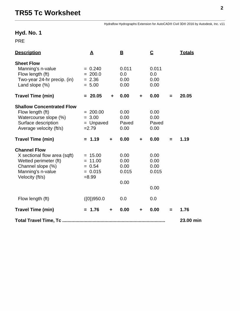
TR55 Tc Worksheet2
Hydraflow Hydrographs Extension for AutoCAD® Civil 3D® 2016 by Autodesk, Inc. v11
Hyd. No. 1
PRE
Description A B C Totals
Sheet FlowManning's n-value = 0.240 0.011 0.011Flow length (ft) = 200.0 0.0 0.0Two-year 24-hr precip. (in) = 2.36 0.00 0.00Land slope (%) = 5.00 0.00 0.00
Travel Time (min) = 20.05 + 0.00 + 0.00 = 20.05
Shallow Concentrated FlowFlow length (ft) = 200.00 0.00 0.00Watercourse slope (%) = 3.00 0.00 0.00Surface description = Unpaved Paved PavedAverage velocity (ft/s) =2.79 0.00 0.00
Travel Time (min) = 1.19 + 0.00 + 0.00 = 1.19
Channel FlowX sectional flow area (sqft) = 15.00 0.00 0.00Wetted perimeter (ft) = 11.00 0.00 0.00Channel slope (%) = 0.54 0.00 0.00Manning's n-value = 0.015 0.015 0.015Velocity (ft/s) =8.99
0.000.00
Flow length (ft) ({0})950.0 0.0 0.0
Travel Time (min) = 1.76 + 0.00 + 0.00 = 1.76
Total Travel Time, Tc .............................................................................. 23.00 min

TR55 Tc Worksheet4
Hydraflow Hydrographs Extension for AutoCAD® Civil 3D® 2016 by Autodesk, Inc. v11
Hyd. No. 2
POST
Description A B C Totals
Sheet FlowManning's n-value = 0.240 0.011 0.011Flow length (ft) = 160.0 0.0 0.0Two-year 24-hr precip. (in) = 2.36 0.00 0.00Land slope (%) = 5.00 0.00 0.00
Travel Time (min) = 16.78 + 0.00 + 0.00 = 16.78
Shallow Concentrated FlowFlow length (ft) = 770.00 0.00 0.00Watercourse slope (%) = 1.00 0.00 0.00Surface description = Paved Paved PavedAverage velocity (ft/s) =2.03 0.00 0.00
Travel Time (min) = 6.31 + 0.00 + 0.00 = 6.31
Channel FlowX sectional flow area (sqft) = 15.00 0.00 0.00Wetted perimeter (ft) = 11.00 0.00 0.00Channel slope (%) = 0.54 0.00 0.00Manning's n-value = 0.015 0.015 0.015Velocity (ft/s) =8.99
0.000.00
Flow length (ft) ({0})1200.0 0.0 0.0
Travel Time (min) = 2.23 + 0.00 + 0.00 = 2.23
Total Travel Time, Tc .............................................................................. 25.30 min

Figures