
Storm Watch 2010
24
JUNE 27, 2010 | SUNDAY SUN SPECIAL | 1
-
Upload
nation-publishing-co-limited -
Category
Documents
-
view
227 -
download
4
description
Be prepared for the 2010 Hurricane Season with this comprehensive guide.
Transcript of Storm Watch 2010

JUNE 27, 2010 | SUNDAY SUN SPECIAL | 1

2 | SUNDAY SUN SPECIAL | JUNE 27, 2010
SHOULD THE WORST HAPPEN,physically challenged Barbadians willhave shelters to go to during thishurricane season.
According to the list put out by theMinistry of Education and HumanResource Development, five emergencyshelters with bathrooms accessible topersons in wheel chairs, have beenprominently highlighted.
They include, Coleridge & ParrySchool, St Peter; St ChristopherPrimary, Christ Church; Lester VaughnSecondary School, St Thomas, as wellas George Lamming Primary and StAmbrose Primary in St Michael.
There are 128 hurricane shelters onthe 2010 list including 59 Category 1public school shelters; 30 Category 2public school shelters; 20 Category 1private shelters and 19 Category 2private shelters.
Category 1 shelters arethose which may be usedduring a hurricane orother hazard event.
Category 2 shelters maybe used if they are still in areasonable condition aftera hazard event or disaster.
Please note that personsseeking refuge in shelters,do so at their own risk, asno guarantee can be giventhat any building willremain standing or behabitable after adevastating hurricane,other hazard or disaster.
It is advisable forpersons to remain in their own houses or seek refugein the homes of friends or relatives or in neighbouringbuildings considered to be structurally sound.
If you plan to remain at home, a strong room,preferably located downstairs in the middle of thehouse should be chosen.
Individuals should prepare emergency kits in casethey have to leave their homes.
Non-perishable food items should be enough to lastfor at least three days.
Ideally, a disaster supply kit should include:• Two-weeks supply of prescription medicines.• Two-weeks supply of non-perishable/special dietaryfoods.• Drinking water in containers: one gallon perperson/per day for two weeks.• Flashlights and batteries for each member of thefamily.• Portable radio and at least seven sets of batteries.• First Aid book and kit including bandages,
antiseptic, tape, compresses, non-aspirin painreliever, anti-diarrhoea medication.• Two coolers – one for food and one for ice.• Plastic tarpaulin for roof/window repair orscreening plus tools, nails and so on.• Water purification kit (tablets, bleach, chlorine(plain) and iodine).• Infant necessities (medicine, sterile water, diapers,ready formula, bottles).• Clean-up supplies (mop, buckets, towels,disinfectant).• Non-electric can opener and plastic trash bags.• Toilet paper, paper towels and pre-moisturisedtowelettes.• Fire extinguisher.• Complete set of clothes, shoes, gloves and so on.• Personal sanitary items.• Important documents (stored in water-tight plasticbags).Pet owners are responsible for the protection of
their pets during disaster events.
If you plan to evacuate, plan for your pet as well. Note that pets are not allowed in public emergency
shelters so make prior arrangements for them.After the disaster event has passed, be careful in
allowing your pets outside as familiar scents andlandmarks might be altered.
Be aware of emergency shelters located in your area. This information can be had from your zonal
committee or the Department of Disaster Management.Do not attempt to seek refuge in a shelter unless
notified by authorities that it has been officiallyopened.
Listen for evacuation advice and leave promptlywhen advised by authorities to do so.
Recognise that a public shelter’s primary function isto provide refuge, that is, a roof over your head.
Weapons, alcoholic beverages and narcotics will notbe allowed in a shelter. Circumstances may also requirea ban on cigarette or cigar smoking.
Before you leave, ensure your family has been fedbefore you take them to the home of a friend or to apublic shelter.
Fill as many containers as possible with water andstore in refrigerator. Fill bathtub and washing machinewith water – you may need this supply when youreturn.
Shut off water and electricity before setting out.Take small valuables and the following important
papers but travel light: Driver’s licence or otheridentification, bankbook/cards, insurance policies,property inventory and photos, device to convey specialmedical information.
Please note shelter managers will not be responsiblefor the storage of valuable items.
Leave early, in daylight if possible and avoid alreadyflooded areas.
JUNE 27, 2010 | SUNDAY SUN SPECIAL | 3
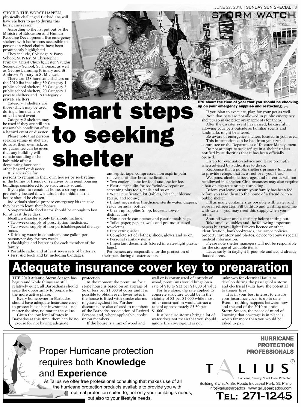
Smart stepsto seekingshelter
IT’S about the time of year that you should be checkingup on your emergency supplies and restocking. (FP)
THE 2010 Atlantic Storm Season hasbegun and while things are stillrelatively quiet, all Barbadians shouldseize the opportunity to prepare forthe more active phase.
Every homeowner in Barbadosshould have adequate insurance coverto protect his or her investment – nomatter the size, no matter the value.
Given the low level of rates inBarbados at this time, there can be no
excuse for not having adequate
protection.At the moment the premium for a
stone house is based on an average of$6 or less per $1 000 of cover and it ispossible to obtain even lower rates ifthe house is fitted with smoke alarmsto guard against fire. Furtherdiscounts are also offered to membersof the Barbados Association of RetiredPersons and, where applicable, creditunion members.
If the house is a mix of wood and
wall or is constructed of entirely ofwood, premiums would hinge on arate of $10 to $12 per $1 000 of value.
For fire alone, the rate applied toconcrete structure would be in thevicinity of $2 per $1 000 while mostother construction would attract arate of approximately $3.50 per $1 000.
Just because storms bring a lot ofwater does not mean that you shouldignore fire coverage. It is not
unknown for electrical faults todevelop during the passage of a stormand electrical faults have the potentialto trigger fires.
It is in your best interest to ensureyour insurance cover is up to date.Even if nothing happens between nowand the end of the 2010 AtlanticStorm Season, the peace of mind ofknowing that coverage is in place isworth far more than you would beasked to pay.
Adequate insurance cover key to preparation

4 | SUNDAY SUN SPECIAL | JUNE 27, 2010
THE 2010 Atlantic Storm Seasonis here and as always the bestline of defence is to be preparedfor anything.
If a severe storm comes, homeand business owners should notbe caught unawares.
Granted these are early daysyet but this is the time thateveryone should be thinkingabout what could possiblyhappen.
This is not the time to arguethat preparations were made forthe hurricane season last yearand it fizzled.
This is not the time to startmaking statements about Godbeing a Bajan and point to thefact that the last major impactoccurred here in 1955 – almost55 years ago.
Anyone who adopts that lineshould remember 2002 and thedamage which was caused to anumber of houses by TropicalStorm Lili – a system which wasrated as a minimal storm.
If a minimal storm wascapable of damagingapproximately 200 homes, whatdoes that say about the overallquality of our housing stock?
What does that say about ourconstruction standards?
Think about it, if a minimal
storm could cause that muchhavoc, visualise the likely impactof something larger likeHurricane Ivan which passed tosouth of Barbados and went onto devastate Grenada.
As far as damage goes the2009 Atlantic Storm Season inthe eyes of many was a dud.
There is another side to thatcoin as well.
The insurance industry wasnot called upon to pay out largesums to honour claims so therehas been no need to adjustinsurance premiums upwards.
By extension local insurancecompanies have not had tocontend with higher reinsurancecosts based on the outcome ofthe 2009 season.
If there was a downsideemerging from last year it wouldhave to be the lower thanexpected precipitation levels.
Rainfall was a lot less thannormal and earlier this year, anumber of Caribbean countrieswere facing drought conditionsbut there are ways of preparingfor those situations.
Given that things are stillrelatively quiet, now is the timeto check individual situations.
Business owners and homeowners should all be aware of the
status of their insurance cover.It might also be wise to
examine the adequacy of thecover based on currentreplacement costs.
Being under-insured can hurtalmost as much as having noinsurance at all.
This is the time to considerthe effectiveness of the drainagesystem in your area. Do you livein one of those districts whichexperiences problems even ifthere is minimal rainfall?
Most of us are content to waitfor government to send crews toclean the gutters and drainagewells in the various communitiesbut the annual hurricane seasonis always a good time todemonstrate some self reliance.
Why not get together and trimthe trees in your area whichappear to be dangerously close tohouses?
If the worst happens inBarbados this year, it could takethree to five days for a stateresponse to kick in.
Residents in their variouscommunities must be able tofend for themselves for at leastthree to five days after an impact.
The hurricane season lasts forsix months – be prepared foranything at anytime.
Best defence a great offence
Christ Church Category 1:Milton Lynch Primary,
Accommodation 55.Senior Warden: William
Grazette, 425-4667 (H), 428-8032(W).
Deputy Senior Warden: MaxineHusbands, 424-3973(H), 428-5276(W).
St Christopher Primary,Accommodation 75.
Senior Warden: AnthonyGraham, 428-6593 (H), 428-7273(W),
Deputy Senior Warden: EdwinWeekes, 420-5981 (H) 428-7273 (W).
The Arthur Smith Primary,Accommodation 75.
Senior Warden: Jennifer Hoyte,422-9350 (H), 427-1072 (W).
Deputy Senior Warden: CecilyClarke, 416-4096(H), 427-1072 (W).
Gordon Walters Primary,Accommodation 40.
Senior Warden, Jennifer Lavine-Hinds, 423-7997 (H).
Deputy Senior Warden, AlphineFarley, 420-9051 (H), 420-1149 (W).
Christ Church Girls School,Accommodation 90.
Senior Warden, Heather Bryan,428-9861 (H), 428-8030 (W).
Deputy Senior Warden, CelestineSmith, 420-9533 (H),
429-8030 (W).
Christ Church Foundation,Accommodation 160.
Senior Warden, RobertCumberbatch, 424-3668(H), 428-9323 (W).
Deputy Senior Warden JenniferGoddard, 428-4995 (H) 428-9323 (W).
St Philip Category 1:Hilda Skeene Primary,
Accommodation 32.Senior Warden, Ivan Clarke
437-5303 (H), 423-6135 (W).Deputy Senior Warden, Medford
Kirton 423-5517 (H), 423-1299 (W).
Princess Margaret Secondary,Accommodation 60.
Senior Warden, Dr WismoreButcher, 423-7608 (H), 423-6660 (W).
Deputy Senior Warden, DentonBrathwaite, 423-4405 (H), 423-5262 (W).
St Mark’s Primary,Accommodation 35.
Senior Warden Keith Ward, 423-0269 (H), 423-7340 (W).
Deputy Senior Warden WinstoneProverbs, 423-9744 (H), 423-7340 (W).
St Philip Primary,Accommodation 45.
Senior Warden Owereal Linton,420-2502 (H), 423-6582 (W).
Deputy Senior Warden, ClintonKirton 423- 2419 (H), 423-6582 (W).
Reynold Weekes Primary,Accommodation 60.
Senior Warden Joseph Clarke416-4096 (H), 416-4648 (W).
Deputy Senior Warden TyroneMarshall 624-0027 (H), 416-5116 (W).
St John Category 1The Lodge School,
Accommodation 50.Senior Warden Trevor Pilgrim
423-6982 (H), 423-3834 (W).Deputy Senior Warden Vasco
Dash 420-4235 (H), 423-0086 (W).
St John Primary,Accommodation 55.
Senior Warden Wendy Antrobus423-1104 (H), 433-1655 (W).
Deputy Senior Warden PatrickClarke 416-4656 (H), 433-1665 (W).
St James Category 1Good Shepherd Primary,
Accommodation 84.Senior Warden Lorna Bynoe,
424-7864 (H),417-5862 (W).Deputy Senior Warden Carlton
Reid, 424-1064 (H), 417-5862 (W).
Queen’s College,Accommodation 100.
Senior Warden Dr, DavidBrowne, 428-8368 (H), 424-9960 (W).
Deputy Senior Warden JuanitaWade 443-9985 (H), 424-9965 (W).
St Alban’s Primary,Accommodation 45.
Senior Warden Angela Ramsay438-4500 (H).
Deputy Senior Warden WendyAlleyne 425-4161 (H), 439-8204(W).
St James SecondaryAccommodation 80.
Senior Warden Joy Henry 438-4525 (H), 432-0136 (W).
Deputy Senior Warden JeffersonPhillips 439-7484 (H), 432-0136 (W).
St Michael Category 1 Grazettes Primary,
Accommodation 80.Senior Warden Nola Cummins-
Lewis 421-6796 (H), 425-1177 (W).Deputy Senior Warden Moreen
Parris 433-4027 (H),425-1177 (W).
Harrison College,Accommodation 60.
Senior Warden WinstonCrichlow 429-3821 (H), 426-4542 (W).
Deputy Senior Warden JosephMaynard 420-1469 (H) 427-2261 (W).
• Continued on page 15.
Category 1 public shelters
THIS HURRICANCE SEASON don’t leave anything to chance, plan with your safety in mind. (RC)

Christ Church Category 2St David’s Primary, Accommodation 60.Senior Warden Donna Allman
427-3309 (H) 437-1874 (W).Deputy Senior Warden Leila Puckerin
423-0312 (H) 437-1874 (W).St Lawrence Primary, Accommodation 2.Senior Warden Gloria Bryan 423-6448 (H)
429-7644 (W).Deputy Senior Warden Loleta Griffith
428-0319 (H) 420-7644 (W).Vauxhall Primary, AccommodationSenior Warden Lionel Stoute
423-4132 (H) 437 -0447 (W).Deputy Senior Warden Petrina Husbands
228-9110 (H) 437-0447 (W).St Bartholomew’s Primary,
Accommodation 40.Senior Warden Merline Padmore
435-6121 (H) 428-8079 (W).Deputy Senior Warden Petrona Holder 428-3122 (H).
St John Category 2 Mount Tabor Primary, Accommodation 40.Senior Warden Wayne Drakes 428-9801 (H)
433-1747 (W).Deputy Senior Warden Elvia Stuart 433-2831 (H)
433-1438 (W).St Margaret’s Primary Accommodation 40.Senior Warden Hetty McClean 426-5800 (H)
433-1197 (W).Deputy Senior Warden Shirleen Payne
425-2690 (H) 433-1197 (W).Society Primary Accommodation 50.Senior Warden Cynthia Greaves
437-9657 (H) 423-0067 (W).Nancy Herbert 424-4177 (H) 423-0067 (W).
St Michael Category 2Belmont Primary Accommodation 30.Senior Warden Jacqueline Holder
436-5496 (H) 429-4311 (W).Deputy Senior Warden Erskine Watson 421-6194 (H)
429-4311 (W).Deacon’s Primary Accommodation 60.Senior Warden Shirley Marshall
425-8122 (H)425-9312 (w).Deputy Senior Warden Dr Sandra Anderson 424-1669
(H) 425-9312(W).Parkinson Memorial Accommodation 75.Senior Warden Orson Alleyne 420-8122 (H)
427-2553 (W).Deputy Senior Warden Maxine Mayers 429-8656 (H)
427-2553 (W).Grantley Prescod Memorial Accommodation 60.Senior Warden Marlene Abrams
424-0675 (H) 426-0772 (W).Deputy Senior Warden Vaman Harbin 428-7225 (H)
426-0772 (W).St Giles’ Primary
Accommodation 120.Senior Warden Claudette
Moseley-Clarke 428-5797(H) 426-0105 (W).
Deputy Senior WardenFrederick Bailey 423-6915(H) 427-0173 (W).
Wesley Hall Infants’ Accommodation 30.
Senior Warden SylviaScantlebury 424-7464 (H) 429-3813 (H).
Deputy Senior WardenWendy Barrow 426-4747(H)429-3813 (W).
Wesley Hall Junior Accommodation 65.
Senior Warden MaureenReid 425-5438 (H) 426-5681 (W).
Wilkie CumberbatchPrimaryAccommodation 120.
Senior Warden MargaretSt Hill-Pinder 428-2134 (H)431-9604 (W).
Deputy Senior WardenLivingstone Jones 438-2636(H) 429-4511 (W).
St Mary’s PrimaryAccommodation 80.
Senior Warden JenniferRobinson 428-0693 (H) 427-2997 (W).
Deputy Senior Warden Marvaline Chadderton 424-8414 (H).
Hindsbury Primary Accommodation 70.Senior Warden Etwyn Bynoe 438-1258 (H)
427-3657 (W).Deputy Senior Warden Anderson Forde 426-0425 (H)
431-2129 (W).Eagle Hall Primary Accommodation 40.Senior Warden Marcia Best 425-8503 (H) 429-5971
(W).Deputy Senior Warden Emelda Bell 424-4190 (H)
421-7515 (W).St Paul’s Primary Accommodation 165.Senior Warden Sandra Small-Thompson 426-2583 (W).Deputy Senior Warden Harriet Hunte 416-5154 (H)
426-2583 (W).
St James Category 2St James Primary Accommodation 58.Senior Warden Margaret Branford 425-1413 (H)
432-1341(W).Deputy Senior Warden Barbara-Ann Broome-Bailey St Silas Primary Accommodation 35.Senior Warden Eugene Eastmond 432-9408 (H)
422-3560 (W).Deputy Senior Warden Colleen Phillips 432-9054 (H)
432-9408 (W).West Terrace Primary Accommodation 100.Senior Warden Ovid
Gibbs 421-7101 (H) 438-3000 (W).
Deputy Senior WardenDelores Collymore 438-3000/01 (W).
St LucyCategory 2
Half Moon Fort PrimaryAccommodation 100.
Senior Warden JudySobers 424-5649 (H)
439-8274 (W).Deputy Senior Warden Anderson Boyce 438-2359 (H) 439-8274 (W).Selah Primary Accommodation 150.Senior Warden Beverley Burrowes
438-3540 (H) 439-8204 (W).Deputy Senior Warden Anderson Bishop 438-2321 (H)
439-8204 (W).St Lucy Secondary Accommodation 50.Senior Warden Stephen Jackman 489- 6949.Deputy Senior Warden Verna Cozier 419-0189 (H)
439-8561 (W).
St Thomas Category 2Holy Innocents’ Primary Accommodation 40.Senior Warden Marjarita Sobers 439-8428 (H)
438-6625 (W).Deputy Senior Warden Herbert Millar 428-5009 (H)
438-6625 (W).Welches Primary Accommodation 45.Senior Warden D’orsus Barker
424-6478 (H) 421-6106 (W).Deputy Senior Warden Carmeta Small 421-6500 (H).
St George Category 2South District Primary Accommodation 80.Senior Warden Orry Butcher 423-6710 (H) 4
37-4804 (W).Deputy Senior Warden Jacqueline Sealy 438-3604 (H)
437-1874 (W).St Andrew Category 2Chalky Mount Primary Accommodation 30.Senior Warden Glendene Thompson 422-6473 (H)
422-9271 (W).Deputy Senior Warden Katrina Wooding-Small
421-9800 (H) 422-9271 (W).
St Peter Category 2Alexandra School Accommodation 155.Senior Warden Jeffrey Broomes 432-9294 (H)
422-22654 (H).Deputy Senior Warden Beverley Neblett-Lashley
425-0907 (H) 422-2265 (W).
JUNE 27, 2010 | SUNDAY SUN SPECIAL | 5
Category2 publicshelters
6 | SUNDAY SUN SPECIAL | JUNE 27, 2010
SOME new initiatives are beingimplemented this hurricaneseason.
The Florida-based, NationalHurricane Centre (NHC) hasimplemented changes for 2010 togive areas in the path of a severestorm or hurricane more time toevacuate. The experts also plan tobreak down storm threats byhazards.
According to NHC’s warningcoordination meteorologist DanielBrown: “We know there are morepeople on the coast, people needmore time to prepare, more timeto evacuate. So with those twofactors we decided we could issuethese watches and warnings a littlebit earlier.”
Watches and warnings for bothtropical storms and hurricanes willnow be issued 12 hours earlierthan previous years.
From this year, the alerts will beissued 48 hours before tropicalstorm or hurricane conditions are
anticipated. Tropical storm and hurricane
warnings will be issued 36 hoursbefore the same conditions areexpected.
Officials suggested that ahurricane warning issued 24 hoursbefore the expected arrival of astorm was not enough time to getlarge populations to safer ground.
Giving his take on the situation,NHC director, Bill Read said: “The24-hour warning has been in ourlexicon since way back in the1960s. The skill has almost tripledsince then and unfortunatelyduring that same time frame ourpopulation growth has been byfactors of ten or more. We can’tget people out of harm’s way in 24hours.”
Another major change this yearwill affect the scale on whichstorm surge is based.
The Saffir-Simpson scale whichcategorises hurricanes wasoriginally meant for wind speed
only. Over the years, storm surgewas attached to the wind scale.
Previous storms such asHurricane Ike, demonstrated thatattaching specific storm surgevalues to wind speeds could bemisleading.
Director of the NationalWeather Service Southern Regionoffices Bill Proenza said: “Stormsurge is not directly linked all thetime to wind. For example, aCategory One storm or CategoryTwo ... can have a very significantstorm surge.”
The phenomenon is highlydependent upon the shape andslope of the coastline.
In the United States, Louisianahas a very gentle sloped coastline,making it very susceptible toflooding due to storm surge.
This year, the experts plan toseparate the individual risksassociated with a hurricane,including: winds, storm surge,rain, tornadoes, and waves.
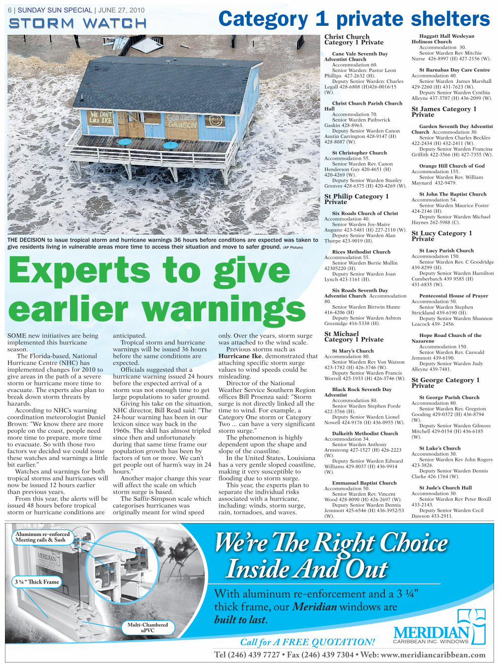
THE DECISION to issue tropical storm and hurricane warnings 36 hours before conditions are expected was taken togive residents living in vulnerable areas more time to access their situation and move to safer ground. (AP Picture)
Christ Church Category 1 Private
Cane Vale Seventh DayAdventist Church
Accommodation 60.Senior Warden: Pastor Leon
Phillips 427-2632 (H).Deputy Senior Warden: Charles
Legall 428-6808 (H)426-0016/15(W).
Christ Church Parish ChurchHall
Accommodation 70.Senior Warden Pathwrick
Gaskin 428-8963.Deputy Senior Warden Canon
Austin Carrington 428-9147 (H) 428-8087 (W).
St Christopher ChurchAccommodation 55.
Senior Warden Rev. CanonHenderson Guy 420-4651 (H)420-4269 (W).
Deputy Senior Warden StanleyGreaves 428-6375 (H) 420-4269 (W).
St Philip Category 1Private
Six Roads Church of ChristAccommodation 40.
Senior Warden Joy-MaireAuguste 423-5481 (H) 227-2110 (W).
Deputy Senior Warden AlanThorpe 423-9019 (H).
Rices Methodist ChurchAccommodation 55.
Senior Warden Bertie Mullin42305220 (H).
Deputy Senior Warden JoanLynch 423-1161 (H).
Six Roads Seventh DayAdventist Church Accommodation80.
Senior Warden Birtwin Hunte 416-4206 (H)
Deputy Senior Warden AshtonGreenidge 416-5338 (H).
St Michael Category 1 Private
St Mary’s ChurchAccommodation 80.
Senior Warden Rev Von Watson423-1782 (H) 426-3746 (W).
Deputy Senior Warden FrancisWorrell 425-1933 (H) 426-3746 (W).
Black Rock Seventh DayAdventist
Accommodation 80.Senior Warden Stephen Forde
422-3766 (H).Deputy Senior Warden Lionel
Nowell 424-9176 (H) 436-0955 (W).
Dalkeith Methodist ChurchAccommodation 34.
Senior Warden AnthonyArmstrong 427-1527 (H) 426-2223(W).
Deputy Senior Warden EdwardWilliams 429-8037 (H) 436-9914(W).
Emmanuel Baptist ChurchAccommodation 50.
Senior Warden Rev. VincentWood 428-8090 (H) 426-2697 (W).
Deputy Senior Warden DennisJemmott 425-6546 (H) 436-3952/53(W).
Haggatt Hall WesleyanHoliness Church
Accommodation 30.Senior Warden Rev Mitchie
Nurse 426-8997 (H) 427-2156 (W).
St Barnabas Day Care CentreAccommodation 40.
Senior Warden James Marshall429-2260 (H) 431-7623 (W).
Deputy Senior Warden CynthiaAlleyne 437-3707 (H) 436-2099 (W).
St James Category 1Private
Garden Seventh Day AdventistChurch Accommodation 30.
Senior Warden Charles Beckles422-2434 (H) 432-2411 (W).
Deputy Senior Warden FrancinaGriffith 422-3566 (H) 427-7355 (W).
Orange Hill Church of GodAccommodation 155.
Senior Warden Rev. WilliamMaynard 432-9479.
St John The Baptist ChurchAccommodation 54.
Senior Warden Maurice Foster424-2146 (H).
Deputy Senior Warden MichaelHaynes 262-5988 (C).
St Lucy Category 1Private
St Lucy Parish ChurchAccommodation 150.
Senior Warden Rev. C Goodridge439-8299 (H).
Deputy Senior Warden HamiltonCumberbatch 439 9585 (H) 431-6835 (W).
Pentecostal House of PrayerAccommodation 50.
Senior Warden StephenStrickland 439-6190 (H).
Deputy Senior Warden ShannonLeacock 439- 2456.
Hope Road Church of theNazarene
Accommodation 150. Senior Warden Rev. Caswald
Jemmott 439-6190.Deputy Senior Warden Judy
Alleyne 439-7481.
St George Category 1Private
St George Parish ChurchAccommodation 80.
Senior Warden Rev. GregstonGooding 429-0372 (H) 436-8794(W).
Deputy Senior Warden GilmoreMitchell 429-0154 (H) 436-6185(W).
St Luke’s ChurchAccommodation 30.
Senior Warden Rev John Rogers423-3826.
Deputy Senior Warden DennisClarke 426-1764 (W).
St Jude’s Church HallAccommodation 30.
Senior Warden Rev Peter Boxill433-2143.
Deputy Senior Warden CecilDawson 433-2911.
Category 1 private shelters
Experts to giveearlier warnings

Samsung E2120
www.time4lime.com
A phone forany weather.
Rain or shine, count on LIME.
179$postpaid
189$prepaid
get a Free giftwith a new Samsung E2120.Offer available while stocks last.
FM radio with built in antennaSpeaker phoneLight weightCamera
JUNE 27, 2010 | SUNDAY SUN SPECIAL | 7
THE SELECTED STORM NAMES forthe 2010 Atlantic Storm season are:
Alex; Bonnie; Colin; Danielle; Earl;Frances; Gaston; Hermine; Igor; Julia;Karl;Lisa; Matthew; Nicole; Otto;Paula; Richard; Shary; Tomas Virginie;Walter.
Since 1953, Atlantic tropical stormshave been named from lists created bythe National Hurricane Centre.
These names are now maintainedand updated by an internationalcommittee of the World MeteorologicalOrganisation (WMO).
The original name lists featuredonly female names but in 1979, malenames were introduced and theyalternate with female names.
Six lists are used in rotation hencethe 2009 list will be used again in2015.
The only time that there is a changein the list is if a storm proved to be sodeadly or costly that the future use ofits name on a different storm would bedeemed inappropriate for reasons ofsensitivity.
If that occurs, then at an annualmeeting by the WMO committee –called primarily to discuss many otherissues – the offending name would bestricken from the list and anothername selected to replace it.
Several names have been changedsince the lists were created.
On the 2007 list which will be usedagain in 2013, Dorian has replacedDean, Fernand has taken over fromFelix and Nestor has made it at theexpense of Noel.
A number of storm names have metthe retirement criteria over the years.
They include : Agnes - 1972; Alicia -1983; Allen - 1980; Allison - 2001;Andrew - 1992; Anita - 1977; Audrey -1957; Betsy - 1965; Beulah - 1967; Bob- 1991; Camille - 1969; Carla - 1961;Carmen - 1974; Carol - 1954; Celia -1970; Cesar - 1996; Charley - 2004;Cleo - 1964; Connie - 1955; David -1979; Dennis - 2005; Diana - 1990;Diane - 1955; Donna - 1960; Dora -1964; Edna - 1968; Elena - 1985;Eloise - 1975; Fabian - 2003; Fifi -1974; Flora - 1963; Floyd - 1999; Fran -1996; Frances - 2004; Frederic - 1979;Georges - 1998; Gilbert - 1988; Gloria -1985; Hattie - 1961; Hazel - 1954;Hilda - 1964; Hortense - 1996; Hugo -1989; Inez - 1966; Ione - 1955; Iris -2001; Isabel - 2003; Isidore - 2002; Ivan- 2004; Janet - 1955; Jeanne - 2004;Joan - 1988; Juan - 2003; Katrina -2005; Keith - 2000; Klaus - 1990; Lenny- 1999; Lili - 2002; Luis - 1995; Marilyn- 1995; Michelle - 2001; Mitch - 1998;Opal - 1995; Rita - 2005; Roxanne -1995; Stan - 2005; Wilma - 2005.s
In the event that more than 21named tropical cyclones occur in theAtlantic basin in the course of a singleseason, additional storms will takenames from the Greek alphabet: Alpha,Beta, Gamma, Delta and so on.
If a storm forms in the off-season, itwill take the next name in the listbased on the current calendar date.
For example, if a tropical cycloneforms on December 28th, it would takethe name from the previous season’slist of names.
If a storm formed in February, itwould be named from the subsequentseason’s list of names.
The businessof naming tropical storms
GO CHECK THERECORDS and don’t besurprised if the 2009Atlantic Storm Season is listed as one of themost uneventful in a longtime.
At the start of theseason residents of theCaribbean Basin and theeast coast of the UnitedStates were warned toexpect a pretty activeseason.
Approaching thehalfway point, an analysisemanating from theFlorida-based NationalHurricane centre (NHC)described the situation inthe Atlantic as “pleasantlyquiet”.
The agency noted thatthere had not been anynamed storms in theAtlantic tropical cyclone
season to that point in2009.
Acording to NHC it wasthe latest start to theseason since 1992 whichsaw the formation ofTropical Storm Andrewformed on August 16, thelatest date for a namedstorm.
By contrast in 2008Tropical Storm Arthurwas churning its wayacross the waters duringthe last days of May.
The Florida-basedagency also noted that a new forecast for the2009 Atlantic StormSeason was on the vergeof being issued by the research team atColorado State Universityand it would lower theprevious estimate of thenumber of storms
anticipated from 14 toten.
The research teamheaded by Dr PhillipKlotzbatch and professorWilliam Gray cited therapid development of El Niño as the primaryreason for reducing theforecast numbers.
Stronger westerlywinds aloft in El Niñoyears create unfavorablewind shear for tropicalcyclone development inthe Atlantic.
Klotzbach and Grayalso warned that eventhough 2009 was shapingup to be a ‘down’ year forhurricanes, the Atlanticbasin remained in anactive multi-decadalhurricane phase expectedto last another ten to 15 years.
2009 the lull before
an active season?

Christ ChurchCategory 2 Private
Hawthorn MethodistChurch Accommodation 60.
Senior Warden CurtisDurant 426-4398, 426-0449.
Deputy Senior WardenAdrian Yard 433-6180 (H)429-2131 (W).
St Matthias ChurchAccommodation -
Senior Warden Rev Devere Murray 427-7389 (H).
Deputy Senior WardenFernando Yearwood 438-2562 (H) 424-9959 (W).
Salvation Army Church(Wotton) Accommodation 40.
Senior Warden Patricia Linton 428-8931 (H) 436-1114 (W).
Deputy Senior Warden Joyce Ward420- 8044 (H) 416-5500 (W).
St Philip Category 2 PrivateSt Martin’s Anglican Church
Accommodation 70.Senior Warden Canon Siebert
Small 416-5319 (H).Deputy Senior Warden David
Hinkson 416-3925 (H) 428-1670 (W).St Mark’s Church Hall
Accommodation 40.Senior Warden Ewart Barrow
423-4309 (H).Deputy Senior Warden Angela
Watson 423-1040 (H).St Catherine Church
Accommodation 40.Senior Warden Arthur Adams
423- 8369 (H) 423-6231 ext 210 (W).Deputy Senior Warden John Clarke
423-4489 (H).Gemswick Nazarene Church
Accommodation 48.Senior Warden Stanley Arthur
416-3818 (H) 426-9693 (W).Deputy Senior Warden Errol Davis
428-8563 (H) 417-3800 (W).Ruby Nazarene Church
Accommodation 30.Senior Warden Victor Nurse 437-4398
(H) 426-5973 (W).Deputy Senior Warden Rev Samuel
Elcock 433-3004 (H).Foursquare Nazarene Church
Accommodation 35.Senior Warden Bernice Gittens
420-1614 (H) 423-6620 (W).Deputy Senior Warden Gweneth
Weekes 420-1114 (H).
St John Category 2 PrivateCodrington College
Accommodation 50.Senior Warden Rev Dr Ian Rock
423-1166 (H) 423-1140 (W).Deputy Senior Warden Errol Maxwell
423-4349 (H) 423-1141 (W).St Gabriel Church
Accommodation 20.Senior Warden Edward Eastmond
423-2718 (H).Deputy Senior Warden Juwane
Brewster 423-3311 (H).
St Michael Category 2 PrivateChapman Street Church of God
Accommodation 50.Senior Warden Richard Lorde
424-4019 (H).
Deputy Senior Warden MalcolmMarshall 417-7702 (W) .
Government Hill Seventh DayAdventist Accommodation 60.
Senior Warden Pastor Sheldon Brome439-9035.
Deputy Senior Warden TyroneMarshall 435-2144 (H) 423-3888 (W).
Haggatt Hall Wesleyan HolinessChurch Accommodation 30.
Senior Warden Rev Mitchie Nurse426-8997 (H) 427-2156 (W).
Deputy Senior Warden OswaldBelgrave 436-4706 (H) 436-0990/1 (W).
St Matthew’s ChurchAccommodation 70.
Senior Warden Priestly Burke 436-0398.
Deputy Senior Warden Rev HughSandiford 424-0882 (H) 427-3712 (W).
Fairfield Gospel HallAccommodation 30.
Senior Warden Franklin Browne 424-2681 (H) 429-4699 (W).
Deputy Senior Warden Tyrone Jones417-9016 (H) 430-4441 (W).
St Paul’s Church Accommodation 50.Senior Warden Rev Wayne Isaacs
435-3489 (H) 426-3106.Deputy Senior Warden 420-4149 (H).Whitehall Methodist Church
Accommodation 55.Senior Warden Timothy Lokey
438-3532 (H) 426-1756 (W).Deputy Senior Warden Cyrus Worrell
424-3935 (H).
St Peter Category 2 PrivateSt Philip-the-Less
Accommodation 45.Senior Warden Gordon Thompson
439-6712 (H).Deputy Senior Warden Roosevelt
Belgrave 439-9263 (H) 436-4800 (W).
8 | SUNDAY SUN SPECIAL | JUNE 27, 2010
Get your current weather
and forecasts from the
Meteorological Services on the
Ministry of Agriculture’s Website
Get satellite Imagery and Statistics
See the services Met Services provides
Get in-depth
weather discussion
www.agriculture.gov.bb
MAThe Ministry of Agriculture
Ministry of Agriculture
ONCE INSIDE any emergency shelter, the seniorwarden is the supreme authority in the shelterand his/her decision is final.
The emergency shelter warden or other shelterwarden designated by the senior warden will beresponsible for the facility in the absence of thesenior shelter warden.
The warden is entitled to call upon anyoccupant of the shelter to assist in its operationand every occupant is expected to cooperate to the best of his or her ability.
If a State of Emergency is proclaimed at anytime under the Emergency Management Act2006-20, all persons within the shelter shall besubject to orders made under the Act and will beliable for such penalties as may be imposed forfailure to comply.
The senior warden and all assistants areforbidden to accept responsibility for any item ofpersonal property of any occupant of the shelter.
The department of Emergency Managementwill not be liable for any damage to, or loss of any property belonging to any occupant.
Any person who is seen defacing or in any waydamaging the shelter or any item of its furnitureor equipment will be prosecuted.
Unseemly, indecent or unsocial behaviorincluding violence, profane language ordrunkenness will not be tolerated and will resultin prosecution where any such offence is contraryto the law.
No smoking of any kind will be allowed in an emergency shelter.
The consumption of alcohol or other alcoholic beverages is strictly forbidden in an emergency shelter.
No firearms nor offensive weapons will be allowed in an emergency shelter.
Category 2private shelters
Shelter rules
CODRINGTON COLLEGE is one of the Category 2 Private shelters inSt John. (FP)
JUNE 27, 2010 | SUNDAY SUN SPECIAL | 9
ACCORDING TO the experts the 2010 Atlantic StormSeason is likely to be “active, to extremely active”.
The National Oceanic and Atmospheric Administration(NOAA) in collaboration with the National HurricaneCentre (NHC) and the Hurricane Research Division (HRD)have spoken of an 85 per cent chance of an above normalseason.
According to the outlook there is only a 10 per centchance of a near normal season this year and a five percent chance of a below-normal season.
The outlook is indicative of an anticipated set ofconditions including exceptionally warm sea surfacetemperatures in the tropical Atlantic Ocean and CaribbeanSea, which are very conducive to increased Atlantichurricane activity.
Such conditions have historically given rise to veryactive hurricane seasons in the Atlantic.
According to the experts, the remainder of the seasoncould well see activity comparable to a number ofextremely active seasons which occurred since 1995.
If the 2010 activity reaches the upper end of thepredicted ranges, it would be one of the most activeseasons on record.
Across the entire Atlantic Basin for the six-monthseason, NOAA has projected a 70 per cent probability ofthe following ranges:
• Between 14 to 23 named storms with top winds of 39 miles per hour or higher.
• The likelihood of eight to 14 hurricanes with topwinds of 74 miles per hour greater and of these three toseven could develop into major hurricanes – Category 3, 4 or 5 with winds of at least 111 miles per hour.
“The main uncertainty in this outlook is how muchabove normal the season will be. Whether or not weapproach the high end of the predicted ranges dependspartly on whether or not La Niña develops this summer,”said lead seasonal hurricane forecaster at NOAA’s ClimatePrediction Centre, Gerry Bell, Ph.D.
“At present we are in a neutral state, but conditions arebecoming increasingly favourable for La Niña to develop”he noted.
NHC director Bill Read in giving his impressions of the2010 season expressed concerns for the people of Haiti,thousands of whom still live in makeshift housingfollowing the devastating earthquake on January 12.
He said heavy rains could trigger serious flooding andmudslides in that impoverished nation which was withoutan evacuation plan for the already displaced communities.
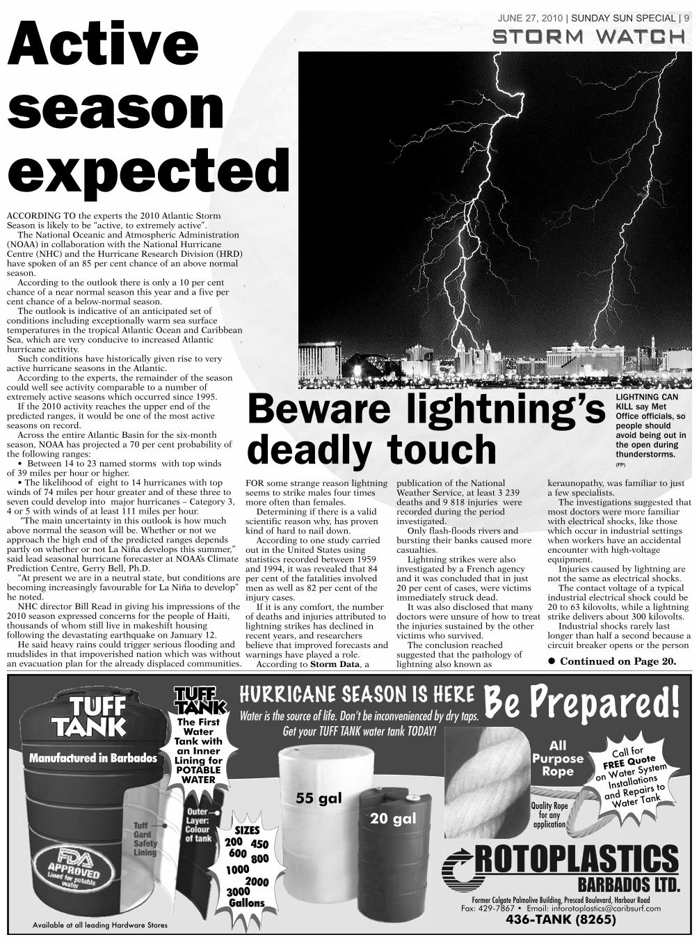
FOR some strange reason lightningseems to strike males four timesmore often than females.
Determining if there is a validscientific reason why, has provenkind of hard to nail down.
According to one study carriedout in the United States usingstatistics recorded between 1959and 1994, it was revealed that 84per cent of the fatalities involvedmen as well as 82 per cent of theinjury cases.
If it is any comfort, the numberof deaths and injuries attributed tolightning strikes has declined inrecent years, and researchersbelieve that improved forecasts andwarnings have played a role.
According to Storm Data, a
publication of the NationalWeather Service, at least 3 239deaths and 9 818 injuries wererecorded during the periodinvestigated.
Only flash-floods rivers andbursting their banks caused morecasualties.
Lightning strikes were alsoinvestigated by a French agencyand it was concluded that in just20 per cent of cases, were victimsimmediately struck dead.
It was also disclosed that manydoctors were unsure of how to treatthe injuries sustained by the othervictims who survived.
The conclusion reachedsuggested that the pathology oflightning also known as
keraunopathy, was familiar to justa few specialists.
The investigations suggested thatmost doctors were more familiarwith electrical shocks, like thosewhich occur in industrial settingswhen workers have an accidentalencounter with high-voltageequipment.
Injuries caused by lightning arenot the same as electrical shocks.
The contact voltage of a typicalindustrial electrical shock could be20 to 63 kilovolts, while a lightningstrike delivers about 300 kilovolts.
Industrial shocks rarely lastlonger than half a second because acircuit breaker opens or the person
Activeseasonexpected
Beware lightning’sdeadly touch
• Continued on Page 20.
LIGHTNING CANKILL say MetOffice officials, sopeople shouldavoid being out inthe open duringthunderstorms.(FP)

10 | SUNDAY SUN SPECIAL | JUNE 27, 2010
THEY ARE relativelyinexpensive and best installedduring the construction phaseand hurricane straps are morethan worth their weight ingold.
During stormy weather,hurricane straps provide extrasecurity for the roof of ahouse.
If high winds compromiseyour roof, generally all thatyou own may be lost due towater damage.
As simple as they look,hurricane straps can keep yourroof in place in the face of 100mile per hour winds or aCategory Two storm system.
Hurricane straps shouldideally be installed during theconstruction phase of abuilding but retro-fitting ofalready existing structures canbe accomplished.
Top quality hurricane strapsare made from galvanised steeland they should be attached toboth the trusses and wallplates.
It is best to put a hurricanestrap on each truss or eachrafter in the roof.
Even though Barbados hasnot been hit by a hurricane inalmost 55 years, a few lesserepisodes in the interim yearshave shown up the value ofincorporating hurricane strapsinto the construction of ahome.
When hurricane experts sitdown to discuss thedestructive power of a severe
storm, the discussionultimately turns to thelessons learnt from thedevastation whichHurricane Andrew leftin its wake.
A team of expertsexamined homes thathad failed as well asothers which hadsurvived. They foundspecific areas including theroof, windows and entry doorswhich should be checked forweakness.
During a hurricane theforce of the wind literallypushes against the outside of ahouse.
This force is transferredfrom the roof through theoutside walls and eventually tothe foundations.
If this energy is notproperly transferred to thefoundation the force of thewinds can cause your house tobe severely damaged if notdestroyed.
The type of roof can alsoinfluence how well a homewould survive a hurricane.
Flat roofs may be thecheapest option to build butthey are also very vulnerableto the lifting forces created byhigh winds.
Perhaps the best option togo with in a hurricane belt isthe parapet roof which was adesign common to plantationhouses in Barbados.
The edges of the roof arehidden behind a wall which
makes it impossible for thewind to get under the edgesand lift.
If that design appeals to youtake particular to keep thedrainage channels free ofleaves and other debris.
Next in line would be thefour-sided hip roof with
minimum overhang.This design tends to be
more aero-dynamic and moreresistant to the uplift forces sotypical of high wind situations.
If your home has a gableroof – two-sided pitched roof –the end wall may take abeating during a hurricane.
Typical framing methodscreate a vulnerable ‘hinge’ lineat the joint between levels andif not properly braced, thegable roof may fail.
Proper bracing of gable endwalls can prevent wind frompushing or pulling the gableend at that weak point.
HURRICANE STRAPS (below) are relatively inexpensive and they help to keep roof tops (above) in place in face of strong storm winds. (FPs)
Hurricanestrapscan saveyour roof

JUNE 27, 2010 | SUNDAY SUN SPECIAL | 11
DURING the passage of asevere storm or hurricane,ordinary every-day objectscan become dangerousmissiles.
There was a time whenresidents of the Atlanticbasin heard a storm wasapproaching, they wouldheavily tape the panes ofglass in their homes with masking tape or other tape.
Experience has shown that tape is ineffective and shutters are a much better option.
There are a number of differenttypes available today.
So the question is, which type of shutters are best for you.
Often the answer comes down to price.
Accordion shutters mount on the inside of the window frame.
They slide out to cover the windowand provide protection when needed,otherwise they are stored out of theway against the window facing.
They are easily deployed in a fewminutes and require no storage.
Aluminium awnings are mountedon the outside of the house above thewindow or door.
They provide shade for the houseoutside of the storm season.
When used for storm protection,two support rods are released and theawning is lowered and bolted down.
Once bolted into place, the awningcompletely covers the window.
Bahama shutters are large louveredpanels attached just above the window
and held away from the house by two support rods.
They are permanently mounted to the side of the house.
When a storm threatens the supportrods are released and the louveredpanels lowered and attached to the house.
A point to note – Bahama shutterscannot be used to protect sliding glass doors.
Colonial shutters were once acommon sight on houses in Barbados.
They flank a window – one oneither side – and many times they are used only for decoration.
When used for protection theyswing inward on hinges to protect the window.
Hurricane panels are made fromeither aluminium or steel that arestored until a storm threatens. Theyslide into place on permanent tracksfastened to the walls above and belowthe window or door.s
Roll shutters are mounted in a boxpermanently attached to the houseabove each window and door. Using a hand crank or electric motor theshutters of plastic or steel are loweredinto place and anchored down forprotection.
Shut outthe storm

12 | SUNDAY SUN SPECIAL | JUNE 27, 2010
HU
RR
IC
AN
E T
RA
CK
IN
G C
HA
RT
Atl
an
tic O
cean
Cari
bb
ean
Sea

BE
FO
RE
•Ke
ep y
our
radi
os t
uned
to
one
of t
he l
ocal
stat
ions
. Mak
e ce
rtain
the
batte
ries
are
fresh
inyo
ur p
orta
ble
radi
o.•
Stay
awa
y fro
m b
each
es a
nd o
ther
low
-lyin
gar
eas
which
may
be
swep
t by
high
tide
s or
sto
rmwa
ves.
Lea
ve e
arly!
Roa
ds to
hig
h gr
ound
may
beco
me
impa
ssab
le h
ours
bef
ore
the
hurri
cane
hits
land
.•
Stor
e an
ythi
ng t
hat
coul
d bl
ow a
way:
gar
bage
cans
, gar
den
tool
s, fu
rnitu
re a
nd p
lant
s. R
emov
etre
e lim
bs th
at c
ould
fall
on y
our h
ouse
or p
ower
lines
.•
Lock
gar
age
door
s. A
wnin
gs s
houl
d be
tie
dse
cure
ly or
take
n do
wn. B
oard
up
wind
ows.
•Do
not
dra
in y
our
swim
min
g po
ol.
Turn
off
all
elec
trica
l poo
l equ
ipm
ent.
Add
extra
chl
orin
e to
avoi
d co
ntam
inat
ion.
•Bo
ats
shou
ld b
e ha
uled
out
or m
oore
d st
rong
ly.Do
not
try
to s
ecur
e yo
ur b
oat i
n ro
ugh
wate
r.•
Mak
e ce
rtain
you
r ca
r is
safe
– p
refe
rabl
y in
aga
rage
. Fill
your
tank
with
gas
olin
e.•
Keep
you
r fla
shlig
ht in
goo
d wo
rkin
g or
der.
Beve
ry c
aref
ul if
you
use
can
dles
and
/or
porta
ble
cook
ing
equi
pmen
t.•
Fill
clean
con
tain
ers
with
drin
king
wate
r. Pu
tla
rge
wate
r con
tain
er in
the
bath
room
. Toi
lets
will
not
flush
if
wate
r su
pply
is in
terru
pted
. Fi
llba
thtu
bs a
nd s
inks
.•
Be s
ure
you
have
ple
nty
of n
on-p
erish
able
food
on h
and.
•Fi
re c
an b
e a
serio
us p
robl
em. H
ave
a go
od fi
reex
tingu
isher
nea
rby.
An a
ltern
ative
is a
buc
ket o
fsa
nd.
DU
RIN
G•
Keep
you
r ra
dio
tune
d co
ntin
uous
ly to
a lo
cal
stat
ion
for f
requ
ent h
urric
ane
upda
tes.
•St
ay in
side!
Lea
ve o
nly
if or
dere
d to
eva
cuat
e.•
If yo
u m
ust d
rive,
wat
ch fo
r fa
lling
trees
, fal
len
wire
s an
d flo
odin
g.•
Keep
one
win
dow
sligh
tly o
pen
on th
e le
ewar
dsid
e of
you
r hou
se. I
f a w
indo
w br
eaks
, go
to a
nin
terio
r roo
m to
avo
id in
jury
from
flyin
g gl
ass.
•Us
e yo
ur te
leph
one
for e
mer
genc
y ca
lls o
nly.
•If
the
eye
of th
e st
orm
pas
ses
over
you
r hou
se,
stay
ins
ide!
The
win
ds w
ill re
turn
sud
denl
y –
poss
ibly
with
eve
n gr
eate
r for
ce.
AF
TE
R•
Keep
you
r rad
ios
tune
d to
a lo
cal s
tatio
n. M
any
prec
autio
nary
ste
ps m
ust
be t
aken
afte
r a
hurri
cane
pas
ses.
•St
ay a
way
from
disa
ster
are
as! S
tay
away
from
brok
en a
nd l
ow-h
angi
ng p
ower
lin
es.
Notif
ypo
lice
or th
e ut
ility
com
pany
of t
he d
amag
e.•
Stay
hom
e! D
o no
t driv
e!•
Ope
n fre
ezer
s an
d ic
e ch
est
only
w
hen
nece
ssar
y un
til po
wer i
s re
stor
ed.
•M
ake
a lis
t of s
torm
dam
age
to y
ou h
ome.
Tak
eph
otog
raph
s of
th
e da
mag
e fo
r In
sura
nce
purp
oses
.
HU
RR
ICA
NE
PR
EC
AU
TIO
NS
EM
ER
GE
NC
YN
UM
BE
RS
PO
LIC
E E
ME
RG
EN
CY
. . . . . . . . .211
DE
PA
RT
ME
NT
OF
EM
ER
GE
NC
YD
EF
EN
CE
FO
RC
EM
AN
AG
EM
EN
T . . . . .427-8
513
EM
ER
GE
NC
Y . . . . . . . . .436-6
185
OR
. . . . . . . . . . . . . . . .438-7
575
FIR
E E
ME
RG
EN
CY
. . . . . . . . . . .311
OR
. . . . . . . . . . . . . . . .422-7
725
Q.E
. H
OS
PIT
AL
. . . . . . . . . .436-6
450
CO
AS
T G
UA
RD
EM
ER
GE
NC
Y– 4
27-8
819
HO
W T
O T
RA
CK
AH
UR
RIC
AN
EAl
way
s ke
ep y
our r
adio
s tu
ned
to a
loca
l sta
tion
sinc
e th
ey g
ive
regu
lar &
relia
ble
bulle
tins
Whe
n a
hurri
cane
form
s ra
dio
stat
ions
in B
arba
dos
will
prov
ide
its e
ye p
ositi
on b
y la
titud
e an
d lo
ngitu
de. (
For
exam
ple,
latit
ude
12.5
deg
rees
nor
th a
nd lo
ngitu
de 4
0.6
degr
ees
wes
t).W
hen
the
stat
ions
bro
adca
st a
hur
rican
e ad
viso
ry, u
se th
e ch
art b
elow
to n
ote
the
perti
nent
info
rmat
ion.
The
n m
ark
the
loca
tion
of th
e hu
rrica
ne o
n th
e tra
ckin
g ch
art.
AH
urr
ican
e W
atc
his
pos
ted
for B
arba
dos
whe
n a
hurri
cane
or a
n in
cipi
ent h
urric
ane
cond
ition
pos
es a
pos
sibl
eth
reat
to th
e is
land
. AH
urric
ane
Wat
ch d
oes
not i
ndic
ate
imm
edia
te d
ange
r. H
owev
er, s
afet
y pr
ecau
tions
requ
iring
mor
e th
an 1
8 ho
urs
to c
ompl
ete,
sho
uld
be s
tarte
d im
med
iate
ly.A
Hu
rric
an
e W
arn
ing
is is
sued
whe
n fo
reca
ster
s be
lieve
the
isla
nd w
ill su
ffer
hurri
cane
dam
age.
AH
urric
ane
War
ning
is is
sued
whe
n w
inds
are
exp
ecte
d to
sus
tain
74
mph
or h
ighe
r with
in 2
4 ho
urs
or le
ss. W
hen
a H
urric
ane
War
ning
is is
sued
list
en to
you
r rad
io s
tatio
ns c
ontin
uous
ly a
nd ta
ke a
ll sa
fety
pre
caut
ions
.A
Tro
pic
al
Sto
rm W
arn
ing
is is
sued
for a
reas
not
dire
ctly
affe
cted
by
the
hurri
cane
. ATr
opic
al S
torm
War
ning
isis
sued
whe
n po
ssib
le s
usta
ined
win
ds w
ithin
the
rang
e of
39
to 7
3 m
ph a
re e
xpec
ted
with
in 2
4 ho
urs
or le
ss.
Your
bes
t pro
tect
ion
is to
sta
y in
form
ed b
y ge
tting
the
deta
ils fr
om ra
dio
bulle
tins.
Whe
n an
y di
sast
er th
reat
ens,
TH
E N
AT
ION
is
your
por
t in
the
stor
m. A
s so
on a
sa
hurri
cane
is b
rew
ing
in o
ur a
rea,
you
get
on-
the-
scen
e co
vera
ge fr
om T
HE
NA
TIO
N’s
awar
d-w
inni
ng re
porte
rs a
nd p
hoto
grap
hers
. Get
all
of th
e st
ory
– th
ew
hole
pic
ture
– in
TH
E N
AT
ION
and
SU
N.
CH
EC
KL
IST
FO
R A
HU
RR
ICA
NE
WA
RN
ING
Batte
ry-o
pera
ted
radi
oPe
ts in
side
or o
ther
wise
pro
tect
edFu
nctio
nal f
lash
light
sLo
ose
outs
ide
obje
cts
stor
ed o
r sec
ured
Batte
ries
for r
adio
and
flas
hlig
hts
Firs
t aid
kit
with
ban
dage
s, a
dhes
ive ta
pes,
Cand
les
and
plen
ty o
f mat
ches
antis
eptic
s, e
tc.
Car t
ank
filled
with
gas
olin
eEx
tra s
uppl
y of
pre
scrip
tion
or e
mer
genc
yEx
tra ic
e in
free
zer
med
icatio
nsG
as fo
r you
r coo
king
unit
Tree
bra
nche
s tie
d or
cut
Extra
drin
king
wate
rTV
ant
enna
take
n do
wnTu
bs a
nd s
inks
fille
d wi
th w
ater
Plen
ty w
ell s
tock
ed: c
anne
d go
ods,
milk
, dry
Fire
ext
ingu
isher
cere
al ,
baby
food
, pow
dere
d dr
inks
and
lots
of E
VE p
rodu
cts
Mo
vem
en
t
Fo
recast
Po
sit
ion
Decreasing
Increasing
Direction
Direction
ForwardSpeed(mph)
Forward Speed(mph)
Central Pressure(inches Hg.)
Maximum Wind(mph)
Longitude (°W)
Latitude (°N
)
Date
Tim
e
(CD
T)
Sto
rm N
am
e
Inte
nsit
y
JUNE 27, 2010 | SUNDAY SUN SPECIAL | 13

THERE IS such a thing as being too relaxed and inBarbados far too many of us are guilty of that.The 2010 Atlantic Storm Season is here and thousandsof us are yet to fully shift into the preparedness mode.
Although it is highly unlikely that anything seriouswill come across the ocean this early in the season, weall need to prepare for any eventuality.
A good point to start would be the sourcing ofseveral large plastic containers for storing water –enough for each member of the household for threeto five days.
When hurricanes impact a small island, expectinterruptions in the power supply at the variouspumping stations and reservoirs.
If landslides occur, there is always the possibilitythat water mains could get broken and suppliescontaminated so play it safe.
If you must use water from the mains, boil it first orpurify it using a few drops of regular household bleach.
Just apply a few drops to each gallon and let it standfor at least an hour before use.
Sometimes cooking is impossible immediately afterthe passage of a severe storm due to interruptions inelectricity supply or breaks in gas lines.
Stock up on non-perishable food items whichrequire little or no cooking.
It might not be Sunday lunch but food items likebiscuits, sardines and corned beef will keep awayhunger pangs quite effectively.
Depending on how seriously the hurricane hasimpacted the country, an immediate state responsemight not be forthcoming so self-reliance is key.
If there is a baby or an elderly person in yourhousehold – ensure that additional supplies ofmedication or special items are secured well aheadof any adverse weather.
While you are at it, put together a first aid kitbecause you never know.
An emergency ambulance response may be renderedimpossible by flooded roads, downed power lines,interrupted communications or fallen trees.
When the hurricane seasons arrives, we all mustdevelop the art of thinking ahead, the ability toanticipate adverse outcomes. It is better to prepare foran event which never occurs than to be caught totallyunaware by a rapidly developing system.
So what must you do to be adequately prepared forthe duration of the Atlantic Storm Season?
First thing, make a list.Include a couple of clothing changes for every one
in the family as well as towels, toothpaste,toothbrushes and other personal care items.
Batteries and flashlights for emergency power area must.
Include a portable radio and ensure that everyone’scell phone is fully charged because if the land linesgo down, they may be the only link with the outsidefor sometime.
Excessive rainfall and flooding are alwayscharacteristics of severe storms so raincoats and bootsare a must.
If you plan to assist in the post-storm clean up,throw in some heavy gloves because you don’t knowwhat might be out there.
How fast your area recovers from the onslaughtof a hurricane will depend of the level of cooperationwhich exists there.
Now is the time to determine how many 4x4 vehiclesare there because with their road clearance and offroad capability, they could be worth their weight ingold.
Meet with your neighbours, come up with anemergency response plan and know how many portablegenerators are around, how many chain saws and who
has lifting equipment.It has been a very long time since Barbados was last
impacted by a hurricane, if it occurs this year, it will bea real learning experience for the vast majority so startyour preparations now.
14 | SUNDAY SUN SPECIAL | JUNE 27, 2010
Distributed by
RATHER than waiting for the issue of a tropical storm orhurricane warning to rush with everyone else to thesupermarket to stock up on non-perishable supplies, whynot buy an extra food item each time you go shopping andgradually build up your stores. (FP)
Readinessnot to betaken lightly

• From page 4.
Lawrence T GayMemorial, Accommodation 100.
Senior Warden BeverleyParris 422-1655 (H) 425-1083(W).
Deputy Senior WardenMarlene Russell 422-1658 (H),425-1083 (W).
Luther Thorne Memorial,Accommodation 100.
Senior Warden Philip Roach421-6559 (H), 436-0811 (W).
Deputy Senior WardenOdessa Downes 416-4224 (H).
St Leonard’s Boys’Secondary,Accommodation 50.
Senior Warden Joseph King420-2681 (H), 427-2997 (W).
Deputy Senior Warden KarlRawlins 428-0441 (H).
St Matthew’s Primary,Accommodation 45.
Senior Warden EleanorBrathwaite 420-9754 (H), 426-0520 (W).
Deputy Senior WardenAngela Edwards 422-6115 (H),
426-0520 (W).
St Stephen’s Primary,Accommodation 100.
Senior Warden WinonaPrice 439-5948 (H) 425-1178 (W).
Deputy Senior Warden MaryLucas 424-2945 (H) 425-1178 (W).
Barbados CommunityCollege, Accommodation 50.
Senior Warden Dr GladstoneBest 428-2066 (H), 426-3186 (W).
Deputy Senior Warden Dr Sylvia Hackett 424-6261 (H),429-5607 (W).
Bay PrimaryAccommodation 50.
Senior Warden MarielonGamble 427-7252 (H), 436- 6073 (W).
Deputy Senior WardenJennifer Sealy 424-6622, 436-6073 (W).
Charles F BroomeMemorial Primary.Accommodation 100.
Senior Warden HortenceCarrington 424-3677(H), 429-3361 (W).
Deputy Senior WardenCheryl Forde 435-6061 (H).435-0786 (W).
Combermere School.Accommodation
Senior Warden Vere Parris,429-0113 (H), 429-2822 (W).
Deputy Senior Warden JuneBrowne 429-0833 (H), 4293685 (W).
Eden Lodge Primary,Accommodation 70.
Senior Warden SandieWorrell 424-9054 (H), 425-1192 (W).
Deputy Senior WardenBeverley Piggott 420-59-29 (H)425-1192 (W).
Ellerslie SecondarySchool, Accommodation 55.
Senior Warden Idelle Austin424-0095 (H).
Deputy Senior WardenRonald Leacock 425-0450 (H),425-1094 (W).
Garrison Secondary,Accommodation 150.
Senior Warden MatthewFarley 426 -5414 (H), 427-0597 (W).
Deputy Senior Warden
Courtney Senhouse 416-5162 (H) 427-0597 (W).
Springer MemorialSecondary,Accommodation 110.
Senior Warden PaulineBenjamin 437-1473 (H), 429-2531 (W).
Deputy Senior WardenBeverley Bancroft 423-4900(H), 429-3673 (W).
University of the WestIndies, Accommodation 100.
Senior Warden Oral Reid416-9358 (H).
Deputy Senior WardenCharles Boyce 243 5590 (H)417-4159 (W).
Westbury Primary,Accommodation 100.
Senior Warden MichaelAlleyne 429-5019 (H), 429-3804 (W).
Deputy Senior WardenPatricia Lovell 435-7442 (H),429-4171 (W).
The St Michael School,Accommodation 105.
Senior Warden, SheltonPerkins 420-1567 (H), 426-3116 (W).
Deputy Senior Warden NoelGittens 425-1656 (H), 436-7863 (W).
George Lamming Primary,Accommodation 72.
Senior Warden BarbaraGrant 428-4508 (H) 430-2927(W).
Deputy Senior WardenPamela Small-Williams 422-0149 (H) 430-2927 (W).
St Ambrose Primary,Accommodation 70.
Senior Warden JacquelineAndwele 432-6268 (H) 436-6060 (W).
Deputy Senior WardenEverton Hall 424-0340 (H) 436-6060 (W).
St Peter Category 1All Saints’ Primary,
Accommodation 42.Senior Warden Keith
Headley 422-3863 (H) 422-6506 (W).
Deputy Senior WardenGrace Gill 439-8354 (H) 422-6506 (W).
Coleridge & Parry School,Accommodation 165.
Senior Warden VincentFergusson 422-1994 (H), 422-3323 (W).
Deputy Senior WardenSeymour Worrell 422-4481 (H).
Gordon GreenidgePrimary, Accommodation 50.
Senior Warden AngelaSmith 439-7982 (H) 422-4298 (W).
Deputy Senior WardenGeorge Francis 432-9327 (H)422-4298 (W).
Roland Edwards Primary,Accommodation 35.
Senior Warden MichaelWatson 422-8023 (H), 422-2873 (W).
Deputy Senior WardenVeronica Best 432-6853 (H)422-2873 (W).
St Lucy Category 1Ignatius Byer Primary,
Accommodation 60.Senior Warden Priscilla
MIllar 438-2532 (H) 439-8359 (W).
Deputy Senior WardenPeggy Gilkes 422-8733 (H) 439-8359 (W).
St Lucy Primary,Accommodation100.
Senior Warden CynthiaRobinson 439-8937 (H)439-6298(w).
Deputy Senior WardenSandra Fields 429-7685 (H)439-8298 (W).
St Thomas Category 1Sharon Primary,
Accommodation 40.Senior Warden Ronald
Bradshaw 428-5899 (H) 425-0167 (W).
Deputy Senior WardenStephney Proverbs-Bennett439-8355 (H) 439-7247 (W).
Lester Vaughn,Accommodation 115.
Senior Warden DianaWilson 420-6733 (H), 417-9250 /51(W).
Deputy Senior WardenMildred Bourne 424-9606 (H)417-9250/51 (W).
Hillaby/Turner’s Hall,Accommodation 35.
Senior Warden Karen Best420-3861 (H) 438-7900 (W)
Deputy Senior WardenSheldeen Gibbs 425-3351 (H)438-7900 (W).
St George Category 1Cuthbert Moore Primary,
Accommodation 60.Senior Warden Eudora
Mascoll 428-4784 (H)
437-7897 (W).Deputy Senior Warden
Deborah Waithe-Jones 428-2313 (H) 437-9778 (W).
Ellerton Primary,Accommodation 100.
Senior Warden LeslieGamble 428-5167 (H) 429 -0228 (W)
Deputy Senior WardenShona Gill 416-4791 (H) 429-0228 (W).
St George Primary,Accommodation 40.
Senior Warden VernaGreaves 420-5257 (H) 429-4280 (W).
Deputy Senior WardenPatricia Springer 416-3698 (H)429-4280 (W).
St George Secondary,Accommodation 70.
Senior Warden CatherineJordan 424-9884 (H) 429- 4787 (W).
Deputy Senior WardenShirley Harper 422-1057 (H)429-4787 (W).
St Jude’s Primary,Accommodation 30.
Senior Warden MercillaWood 429-0096 (H) 433-1545 (W).
Deputy Senior WardenCatherine Eastmond 420-6405(H) 433-1545 (W).
St Luke’s Primary,Accommodation 35.
Senior Warden AngelaDowridge-Browne 420-2733 (H)427-2537 (W).
Deputy Senior Warden AnitaBrathwaite 420-9042 (H) 427-2537(W).
Workman’s Primary,Accommodation 40.
Senior Warden AntheaNewton-Gadbsy 435-1391 (H)429-0071 (W).
Deputy Senior WardenGlendene Hayde 433-3929 (H)429-0071 (W).
St Joseph Category 1St Bernard’s Primary,
Accommodation 40.Senior Warden Yvonda
Hurley 424-0197 (H) 433-8354 (W).
Deputy Senior WardenGeorge Maynard 433-8378 (H)433-8354 (W).
Grantley Adams Memorial,Accommodation 135.
Senior Warden John Mascoll424-6090 (H) 433-1324 (W).
Deputy Senior WardenReginald Banfield 433-8473(H) 433-1324 (W).
St Joseph Primary,Accommodation 45.
Senior Warden ClodaAlleyne 437-6182 (H) 433-4768 (W).
Deputy Senior WardenShirley Thomas 435-1797 (H)433-4678 (W).
St Elizabeth ResourceCentre, Accommodation 20.
Senior Warden StephenClarke 433-9437.
Deputy senior Warden NigelOliver 433-9325.
St Andrew Category 1Alleyne School,
Accommodation 80.Senior Warden Cheryl Wade
424-4900 (H) 422-9230 (W).Deputy Senior Warden
Erwin Boyce 422-9153 (H) 422-9329 (W).
St Andrew Primary,Accommodation 40.
Senior Warden Cheryl Watts438-2363 (H) 422-9024(W).
Deputy Senior WardenJesford Francis 421-9889 422-9024 (W).
Category 1 public shelters
JUNE 27, 2010 | SUNDAY SUN SPECIAL | 15
AFTER VIDEO and stills of thedevastation caused in 1992 byHurricane Andrew in the UnitedStates ere aired, a lot of viewersworld wide, were left breathless bythe scale of the devastation.
How could such happen in oneof the richest and most developedcountries and technologicallyadvanced on the face of the earth?
For many years, the risk ofsignificant property loss due tohurricanes seemed small. Manyhomes along the United StatesEast and Gulf coasts were builtduring the 1970s and 1980s – aperiod of relatively inactivehurricane formation, hence manyproperty owners were blissfullyunaware of the destructivepotential of tropical storm system.
Many people living in coastalareas during the period grew upand never experienced the effectsof an intense hurricane.
After all, Florida the state mostat risk from hurricane damage,had not seen a major hurricanesince Betsy in 1965.
Hurricanes were therefore seenas infrequent events, and stormsthat did occur had been low inintensity.
Consequently, both homeownersand government agencies regardedthe risk of widespread hurricanedamage as manageable and withinthe scope of private homeinsurance and federally subsidisedflood insurance.
When homes were damaged byhurricanes, they were usuallyrepaired to their pre-stormcondition, but scarcely upgradedto reduce or mitigate damage from
the next event. The hurricane risk during those
20-odd years may not have seemedsufficient to warrant the increasedinvestment but hurricanes Hugo(1989) and Andrew (1992)redefined the way the public andthe United States governmentregarded the risk of hurricanedamage to homes.
Hugo and Andrew were thestrongest hurricanes to hit theUnited States East or Gulf coastssince Hurricane Camille batteredLouisiana in 1969. Insurance counted losses
The property insurance industrywhich had in 1986, presumed thattwo US$7 billion hurricanes wouldbe the most catastrophic loss theindustry could expect in a givenyear, was stunned by the US$15.5billion loss from HurricaneAndrew.
The size of the losses fromCategory Five Hurricane Andrewdemonstrated that the damage thata single hurricane could do hadbeen seriously underestimated.
Along with a heightenedawareness of the risks to propertyposed by hurricanes, there was anincreased appreciation of thelikelihood of catastrophic damage,in view of escalating populationand development in hurricane-prone areas.
In the last two decades, thepopulation along high-riskcoastlines has increasedsignificantly.
Concurrent with populationincreases in hazard-prone areas,there is evidence that the future
will bring more intense hurricanes– Categories three to five on theSaffir-Simpson scale – to theUnited States East and Gulfcoasts.
In a September 11, 1995,interview with Time magazine,Professor William Gray said “we’regoing to see hurricane damage likewe’ve never seen it before”.
Gray is known for his researchinto Atlantic hurricanes and hisincreasingly accurate annualpredictions.
In his paper “Strong AssociationBetween West African Rainfall andUnited States Landfall of IntenseHurricanes,” Gray presentedevidence of a high positivecorrelation between rainfall in theWest African Sahel and theincidence of intense hurricanesmaking landfall along the UnitedStates east coast.
Gray found that during periodsof West African Sahel droughtthere were few intense hurricanesmaking United States East Coastlandfalls, while during rainyperiods in the Sahel, a greaternumber of intense hurricanesmake United States east coastlandfall.
Increased Sahel rainfallproduces slow-moving squallsystems-easterly waves – whichcan promote hurricane formation.
The frequency of intenseAtlantic hurricanes also doublesduring periods of Sahel rainfall.
As far as the Caribbean isconcerned what has implicationsfor the United States during theannual storm season, may haveconsequences for us too.
US no strangerto storms’ fury

16 | SUNDAY SUN SPECIAL | JUNE 27, 2010
DURING PERIODS of calmweather, there is nothing as idyllic as living within sight and sound of the sea.
All this can change in a fewhours after an announcement thata storm system is coming acrossthe water.
Now that the 2010 AtlanticStorm Season is here, peopleliving and working in coastal areasshould be on their guard.
While it is true that very littlegenerally happens during the firsthalf of the six month hurricaneseason, there can be no excuse for complacency.
Individuals should be prepared to evacuate and seek shelter further inland as soon as word of an approaching system isreceived.
All evacuations should be completed well in advanceof the onset of high winds and heavy rainfall which caneasily flood roads, making escape difficult or nearimpossible.
It is also advisable that residents move to saferground, during daylight hours when they can still seeany potential hazards like downed trees or power lines.
Those whose lifestyles and livelihoods are closelyconnected to coastal areas should pay attention to anydevelopments which might occur between now and theclose of the 2010 hurricane season.
Buildings close to the shore can suffer majordamage due to phenomena like storm surge but theurge to exploit the economic potential and allure of theclear water and white sand, often seems to overwhelmall else.
For those who have never seen it, storm surge isnothing to ignore.
It occurs when water is pushed ashore by the forceof the winds associated with a strong tropical storm orhurricane.
This advancing surge combines with normal tides to
create a hurricane storm tide, which can increase themean water level 15 feet or more.
Added to that, wind driven waves are superimposedon the storm tide.
So significant is the rise in water level that it cancause severe flooding in coastal areas, particularlywhen the storm tide coincides with normal high tides.
The potential for economic loss at such times issomething which insurance companies are well awareof and should there be a major event in Barbados,owners of affected coastal properties should expectpremium increases down the road.
It has been said that few areas in the world are as vulnerable to climatic influence as the small states of the Eastern Caribbean.
The small land masses are extremely vulnerable to hurricane and tropical storm impacts.
Human activity including extensive landdevelopment and high population densities in coastal areas, has not helped the situation much either.
As we go forward the likely impact of climatechange could influence activity in coastal areas.
Rising sea levels and a greater probability of moreintense hurricanes are likely to be among the mostserious impacts and if they occur, many Caribbeancountries could face major consequences along or near
their coast lines.In the last 35 to 40 years, Caribbean states have
become extremely dependent on tourism dollars fortheir economic survival but in the race to remaincompetitive, some have compromised their naturalassets.
The need to act decisively and protect coastalareas is overwhelming but whatever is done must recognise the demands which tourismplaces on the coastal environment.
The trouble is, that most Caribbean states have notbeen able to identify another economic driver with thepotential of tourism and if the degradation persists,tourism will suffer.
Given how the Caribbean has been marked over theyears with major emphasis on the white sandy beachesand clear waters, it could be extremely hard to movefuture tourism accommodation and facilities furtherinland but something has to be done.
Coastal residents atgreater risk
THE OCEAN can be a treacherous place whenstorm systems begin to head our way. (FP)

TALK TO ANY experienced seafarer andhe or she would tell you that the lastplace to be when a hurricane or severestorm approaches is out on the openwater.
Safe harbour is vital at such times butlife being what it is, you can’t always getwhat you want.
Over the years several cruise shipshave been out on the water when amajor storm formed.
When something like that happens anexperienced captain will do all that he orshe can to put maximum distancebetween the storm and the vessel.
Any vessel traversing internationalwaters should carry forecasting chartsfrom the Tropical Prediction Centre(TPC) of the Florida-based NationalHurricane Centre (NHC).
TPC’s most widely known function isthe issuance of forecasts and warningsfor tropical cyclones and storms.
TPC also has year-roundresponsibilities beyond those related totropical cyclones.
It is involved with the TPC/NHCoutreach initiatives, as well as appliedresearch and development by theTechnical Support branch and marine-based forecasts and warnings issued bythe Tropical Analysis and ForecastBranch (TAFB).
The latter issues on a daily basis, 104marine and tropical weather-basedproducts including a suite of text andgeographical forecasts plus subtropicaland tropical surface analyses, tropicalweather discussions and satellite-basedrainfall estimates.
TAFB is considered an integral part ofNHC, providing operational andforecasting support during the hurricaneseason.
The charts it produces help seafarersto determine how a hurricane mightmove so they can manoeuvre and avoidit.
Ships with cutting edge technologyon-board are able to receive digitalimages which gives them a good idea ofwhat to expect in terms of the system’smovement.
During the hurricane season, captainsof large ocean going vessels would havetwo potential courses plotted should asystem change course and an alternateroute becomes necessary.
The basic rule says if it is a 24-hourhurricane forecast – a distance of 100miles away from the storm isrecommended.
If it’s a 48-hour hurricane forecast, adistance of 200 miles away from thestorm is the recommended norm.
When a 72-hour hurricane forecast isin the equation, the recommendation is adistance of 300 miles away.
A ship’s captain would decide thewisdom of leaving or returning to portwhen a hurricane is approaching.
With enough advance warning, thereshould be enough time to remove a shipfrom its position of anchor when astorm is nearby and moor it in a saferlocation.
Should the system bedeemed too close, it is bestnot to set out from port.
A hurricane that is up to100 nautical miles awayfrom a dock site canpotentially be verydangerous, so sailorsconsidering returning toport must take that intoconsideration in making afinal decision.
If you are at sea when ahurricane forms you shouldtake every possible step to put as muchdistance between the vessel and thestorm as possible. Avoid the path of thehurricane at all costs.
It is better to delay a trip and gethome safely another day than to take therisk of sailing into a hazardousenvironment.
Here in Barbados, virtually all ourboats are small by comparison.
Even the ice boats used by the fishingindustry, would be deemed smallalongside a large ocean going vessel.
The challenge would be to either getthe fishing fleet to safe harbour or haulthe smaller day boats out of the wateraltogether and secure the larger ones.
To prevent loss of or damage to their
investment, local boat owners would bewell advised to put arrangements inplace well ahead of any crisis and decidewhich haul up point would be bestshould they be out to sea.
Before leaving and seeking personalshelter, fishermen and owners should dotheir utmost to make boats remaining inthe water as watertight as possible.
Remove all electronic equipment andother valuables before leaving for thefinal time.
Ensure that your insurance cover isvalid as well as your registrationdocuments.
If you can, take a photo of the interiorof the boat ahead of the storm and placeit with a written description of all itemsnormally kept on board.
JUNE 27, 2010 | SUNDAY SUN SPECIAL | 17
Stormy seasno friend
THIS BOAT waswashed over the wallat the Bridgetown Portduring HurricaneIvan's fury. (FP)
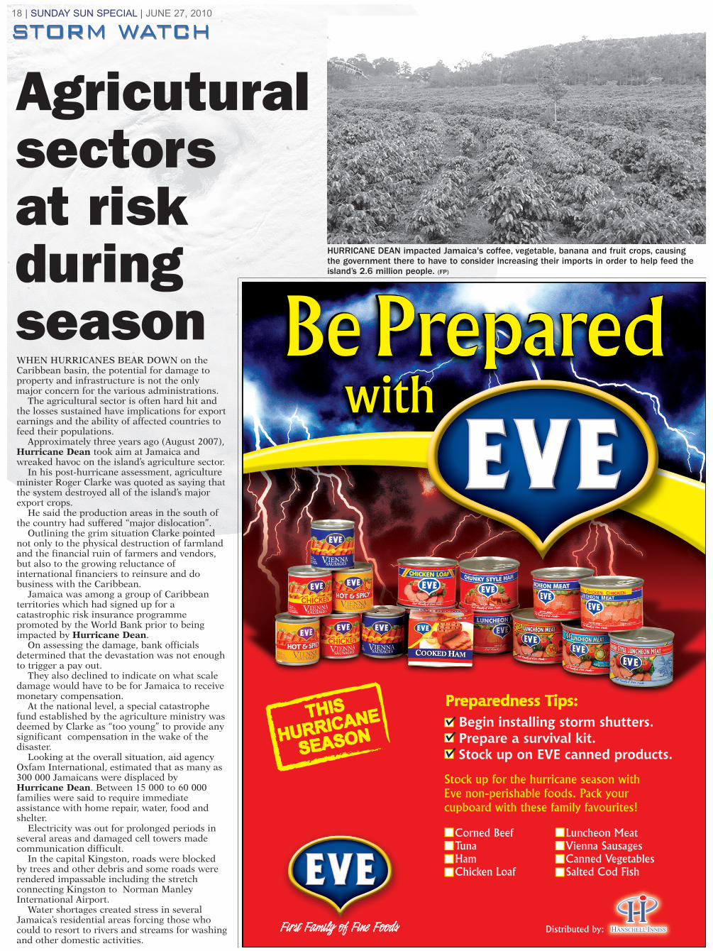
WHEN HURRICANES BEAR DOWN on theCaribbean basin, the potential for damage toproperty and infrastructure is not the onlymajor concern for the various administrations.
The agricultural sector is often hard hit andthe losses sustained have implications for exportearnings and the ability of affected countries tofeed their populations.
Approximately three years ago (August 2007),Hurricane Dean took aim at Jamaica andwreaked havoc on the island’s agriculture sector.
In his post-hurricane assessment, agricultureminister Roger Clarke was quoted as saying thatthe system destroyed all of the island’s majorexport crops.
He said the production areas in the south ofthe country had suffered “major dislocation”.
Outlining the grim situation Clarke pointednot only to the physical destruction of farmlandand the financial ruin of farmers and vendors,but also to the growing reluctance ofinternational financiers to reinsure and dobusiness with the Caribbean.
Jamaica was among a group of Caribbeanterritories which had signed up for acatastrophic risk insurance programmepromoted by the World Bank prior to beingimpacted by Hurricane Dean.
On assessing the damage, bank officialsdetermined that the devastation was not enoughto trigger a pay out.
They also declined to indicate on what scaledamage would have to be for Jamaica to receivemonetary compensation.
At the national level, a special catastrophefund established by the agriculture ministry wasdeemed by Clarke as “too young” to provide anysignificant compensation in the wake of thedisaster.
Looking at the overall situation, aid agencyOxfam International, estimated that as many as300 000 Jamaicans were displaced byHurricane Dean. Between 15 000 to 60 000families were said to require immediateassistance with home repair, water, food andshelter.
Electricity was out for prolonged periods inseveral areas and damaged cell towers madecommunication difficult.
In the capital Kingston, roads were blockedby trees and other debris and some roads wererendered impassable including the stretchconnecting Kingston to Norman ManleyInternational Airport.
Water shortages created stress in severalJamaica’s residential areas forcing those whocould to resort to rivers and streams for washingand other domestic activities.
18 | SUNDAY SUN SPECIAL | JUNE 27, 2010
Agricuturalsectors at risk during season
HURRICANE DEAN impacted Jamaica's coffee, vegetable, banana and fruit crops, causingthe government there to have to consider increasing their imports in order to help feed theisland’s 2.6 million people. (FP)
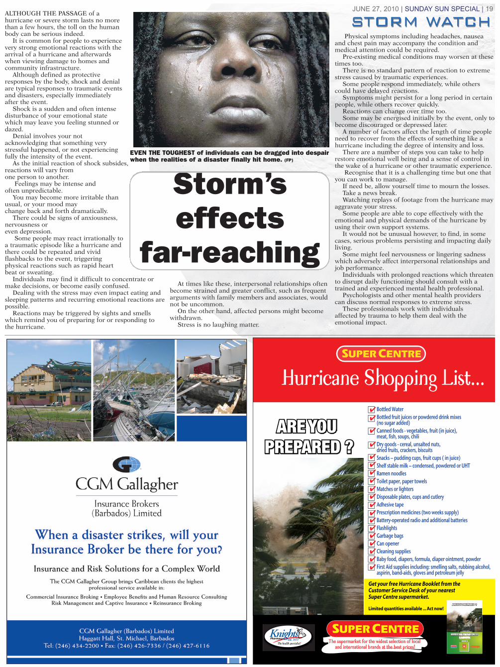
ALTHOUGH THE PASSAGE of ahurricane or severe storm lasts no morethan a few hours, the toll on the humanbody can be serious indeed.
It is common for people to experiencevery strong emotional reactions with thearrival of a hurricane and afterwardswhen viewing damage to homes andcommunity infrastructure.
Although defined as protectiveresponses by the body, shock and denialare typical responses to traumatic eventsand disasters, especially immediatelyafter the event.
Shock is a sudden and often intensedisturbance of your emotional statewhich may leave you feeling stunned ordazed.
Denial involves your notacknowledging that something verystressful happened, or not experiencingfully the intensity of the event.
As the initial reaction of shock subsides,reactions will vary from one person to another.
Feelings may be intense and often unpredictable.
You may become more irritable thanusual, or your mood may change back and forth dramatically.
There could be signs of anxiousness,nervousness or even depression.
Some people may react irrationally toa traumatic episode like a hurricane andthere could be repeated and vividflashbacks to the event, triggeringphysical reactions such as rapid heartbeat or sweating.
Individuals may find it difficult to concentrate ormake decisions, or become easily confused.
Dealing with the stress may even impact eating andsleeping patterns and recurring emotional reactions arepossible.
Reactions may be triggered by sights and smellswhich remind you of preparing for or responding tothe hurricane.
At times like these, interpersonal relationships oftenbecome strained and greater conflict, such as frequentarguments with family members and associates, wouldnot be uncommon.
On the other hand, affected persons might becomewithdrawn.
Stress is no laughing matter.
Physical symptoms including headaches, nauseaand chest pain may accompany the condition andmedical attention could be required.
Pre-existing medical conditions may worsen at thesetimes too.
There is no standard pattern of reaction to extremestress caused by traumatic experiences.
Some people respond immediately, while otherscould have delayed reactions.
Symptoms might persist for a long period in certainpeople, while others recover quickly.
Reactions can change over time too. Some may be energised initially by the event, only to
become discouraged or depressed later.A number of factors affect the length of time people
need to recover from the effects of something like ahurricane including the degree of intensity and loss.
There are a number of steps you can take to helprestore emotional well being and a sense of control inthe wake of a hurricane or other traumatic experience.
Recognise that it is a challenging time but one thatyou can work to manage.
If need be, allow yourself time to mourn the losses. Take a news break. Watching replays of footage from the hurricane may
aggravate your stress. Some people are able to cope effectively with the
emotional and physical demands of the hurricane byusing their own support systems.
It would not be unusual however, to find, in somecases, serious problems persisting and impacting dailyliving.
Some might feel nervousness or lingering sadnesswhich adversely affect interpersonal relationships andjob performance.
Individuals with prolonged reactions which threatento disrupt daily functioning should consult with atrained and experienced mental health professional.
Psychologists and other mental health providers can discuss normal responses to extreme stress.
These professionals work with individuals affected by trauma to help them deal with theemotional impact.
JUNE 27, 2010 | SUNDAY SUN SPECIAL | 19
Storm’seffects
far-reaching
EVEN THE TOUGHEST of individuals can be dragged into despairwhen the realities of a disaster finally hit home. (FP)

20 | SUNDAY SUN SPECIAL | JUNE 27, 2010
is thrown far from the live conductor. Lightning strikes have an even
shorter duration, lasting just a fewmilliseconds. Most of the current froma lightning strike passes over thesurface of the body – a phenomenoncalled external flashover.
Both industrial shocks and lightningstrikes result in deep burns at point ofcontact. In industry the points ofcontact are usually on the upper limbs,hands and wrists, while for lightningthey are mostly on the head, neck andshoulders.
Industrial shock victims sometimesexhibit deep tissue destruction alongthe entire current path, while lightningvictims’ burns tend to centre at entryand exit points. Both industrial shockand lightning victims may be injuredas a result of falling down or beingthrown and the leading cause ofimmediate death for both, tends to becardiac or cardiopulmonary arrest.
If he or she survives the shock, thevictim must face the consequences ofthe electrical burns. Industrial shockburns can lead to kidney failure,infection, muscle and tissue damage, oramputation. Lightning burns can beexceptionally life threatening.
To avoid being struck by lightning,you should seek shelter when you heareven the faintest thunder. Some of thebest places to take refuge are enclosedbuildings, or cars and buses, as long asyou don't touch any metal surfaces.
If there are no safe spaces nearby,bend into a crouching position untilthere is a break in the activity.
Isolated trees, telephone booths, andopen structures like gazebos or porchesmake poor lightning shelters.
If there is a tall object nearby, moveas far away as possible – at least twometres or seven feet.
Standing next to tall isolated objectslike poles or towers makes youvulnerable to secondary dischargescoming off those objects.
• From Page 9.
Stay out ofharm’s wayStay out ofharm’s way

Get discounted shipping rates and complete order tracking from our preferred shipper.Visit Lowes.com/International, order by fax at 704-757-0634, or e-mail [email protected].© 2010 by Lowe’s®. All rights reserved. Lowe’s and the gable design are registered trademarks of LF, LLC. *See store for details.
Find everyday low prices on hurricane supplies.Lowe’s has the supplies you need to get ready for hurricane season, including portable generators, storm shutters, batteries, flashlights and more, all at everyday low prices. If you find a lower price on the same item, we’ll beat it by 10%.* Just visit our store or shop online at Lowes.com/International.
JUNE 27, 2010 | SUNDAY SUN SPECIAL | 21
WHEN WE THINK of theannual Atlantic Storm Seasonmost of us tend to believe thatnothing ever happens during themonth of June but is thatnecessarily true?
If we go back to 1957, therecords will mention a systemcalled Audrey which once heldthe record for being the earlieststorm to reach Category 4strength in the Atlantic basin.
According to the recordbooks Hurricane Audreycaused $1 billion in damage butat today’s value that figurewould be closer to $147 million.
The system also claimed 419lives and was ranked as thesixth deadliest hurricane tostrike mainland United Statessince 1900.
The system developedmaximum sustained winds of145 miles per hour on June 27prior to making landfall nearthe Texas/Louisiana border.
The system eventually wentextra-tropical moving northeastinto the Ohio Valley andnorthwards towards Canada.
With Category 3 strength,Hurricane Alma took aim atFlorida on June 9, 1966.
It was the earliest hurricaneto impact the Americanmainland since 1825 and interms of strength, it was secondonly to Hurricane Audrey.
The damage estimate was$210 million with 90 deaths.
At Category 1 intensity,Hurricane Agnes was knownmore for its torrential rains andflash flooding rather than itswind speeds.
The storm produced morethan 15 inches of rain acrosscentral portions of Pennsylvaniacausing one of the worst floodsin the history of the
Susquehanna River. Agnes came onshore across
the Florida Panhandle on June19, 1972 as a Category 1 system.
Weakening to a tropicaldepression, it moved swiftlythrough central Georgia andinto the Carolinas.
Agnes regained tropicalstorm status on June 21 andmoved back into the AtlanticOcean just off the coast of NorthCarolina. The storm turnednorthwest and moved inlandinto the mid-Atlantic regionnear New York City on June 22.
Agnes merged with a non-
tropical low on June 23,pummeling Pennsylvania andupstate New York withtorrential rains.
Agnes claimed 128 peopleacross eight states- most ofthem flood victims.Pennsylvania recorded 48fatalities, followed by New YorkState with 24. Extensiveflooding was felt as far west asPittsburgh.
Maryland, Pennsylvania, NewYork, Virginia and Florida, weredeemed disaster areas.
Do you still share the view,June too soon?
June storms not unheard of

22 | SUNDAY SUN SPECIAL | JUNE 27, 2010
NATURAL DISASTERS includinghurricanes, can pose major public healthchallenges.
Preparations usually focus on how toevacuate people from affected areas; how toorganise transportation, shelter, food, andwater for evacuees; and how to preventinjury and infection that may develop incrowded living situations.
All of these preparations are vital, but arethey enough?
Consideration should be given to caringfor people whose health was compromisedbefore and who would be more vulnerablethan normal to the stresses and disruptionscaused by natural disasters.
Groups affected by disasters may carry alarge and measurable burden of disabilitiesand chronic diseases, especially heartdisease, cancer, stroke, diabetes, and chronicrespiratory disorders.
Chronic illnesses are exacerbated by theconditions caused by a disaster – lack offood, a shortage of clean water, extremes ofcold or heat, physical and mental stress,injury and exposure to infection.
Natural disasters may also put peoplewith limited mobility as well as women whoare pregnant and their unborn foetuses atincreased risk for adverse health outcomes.
Elderly people with multiple chronicconditions and being treated with multiplemedications, are particularly at risk.
People of low socio-economic status,individuals without health insurance, andthose with mental illness or disabilities mayalso be open to higher morbidity andmortality during disasters.
Similarly vulnerable are ischemic strokesurvivors, diabetics on insulin, heart attackpatients, people with severe lung disease andpatients receiving haemodialysis for kidneyfailure.
Lack of access to routine health carecould be a leading cause of mortality afterdisasters.
In addition, indirect effects – loss ofelectricity – could lead to exposure toextremes of heat or cold or interruption ofsupplemental treatment.
Many people living with disabilities relyon routine health care services to maintaintheir quality of life and live independently.Without access to these services, they mayexperience adverse health events.
Although individual patients and theirfamilies need to be well prepared with clearrecommendations to make preparations,many others must help them.
To ensure an adequate response, disasterpreparation should be coordinated with allpartners, roles should be well defined, andprocedures should be clearly stated.
Responsibilities for each element of theresponse should be assigned in advance.
An adequate means of communicationand standardised health procedures shouldbe available.
Give morethought to health
HURRICANEPREPARATIONSshould also takeinto consideratiopeople whosehealth may becompromised, orexacerbated, asthe result of anatural disaster.(FP)
JUNE 27, 2010 | SUNDAY SUN SPECIAL | 23
KNOWING where a hurricane will strikeand how intense it willbe, are fundamentalchallenges whichconfront meteorologistsyear after year.
The public listens to their predictions indeciding how to respondto what might becoming across the water– when to evacuate and how far.
The advances of the last 50 years have been nothing short ofphenomenal since more accurateinformation has helped to significantlylimit loss of life from systems comingacross the Atlantic Ocean betweenJune 1 and November 30 each year.
Hurricane forecasts were once solelydependent upon relatively sparseobservations of sky and waterconditions, along with occasional ship reports of turbulent weather in the ocean.
In the absence of an adequateanalysis of current weather patterns,plus insufficient knowledge of tropicalmeteorology, forecasts for tropicalstorms and hurricanes were deficient.
These limited forecasts left littletime for preparation before a hurricanemade landfall.
Many of the hurricanes which haveimpacted the United States mainlandin the last 100 years have found aplace on history’s page largely becausethe overwhelming majority, occurredbefore hurricane prediction efforts wereabl e to provide the level of informationneeded to initiate an adequate
response.On that list would be the 1900
hurricane which struck Galveston,Texas, claiming at least 12 000 lives.
The 1928 Lake Okeechobee,Florida hurricane was responsible forat least 2 500 fatalities and the 1936system which struck Long Island, NewYork, and New England with a merefour hours advance warning and leftapproximately 600 deaths in its wake.
As a result of today’s technologicaladvances, the outlook is much morereassuring.
Routine hurricane track forecasts for the Atlantic Basin – the AtlanticOcean, Gulf of Mexico, and CaribbeanSea – began in 1954 but they couldonly provide information one day intothe future.
Forecasts were expanded to give two days advance notice in 1961 and three days by 1964.
Three days was the standard for advance hurricane forecasts up until 2002.
In 2003, boosted by more reliablecomputer models, the National Oceanicand Atmospheric Administration(NOAA), began issuing forecasts up to five days in advance.
Tracking madeeasier withtechnology

24 | SUNDAY SUN SPECIAL | JUNE 27, 2010
Printed and Published by THE NATION PUBLISHING Company LTD., Nation House, Fontabelle, St. Michael, Barbados. Telephone (246) 430-5400