Step-by-step instructions: Steps 1-2 of 9...• 2016 ASCE 7 Standard (ASCE7-16) 0 • 2010 ASCE 7...
8
/ Seismic Design Web Ser,. x Seismic Design Web Service Documentation Web services provided by the U.S. Geological Survey for computing seismic design parameters compatible with various building code reference documents. A This software is preliminary or provisional and is subject to revision . It is being provided to meet the need for timely best science . The software has not received final approval by the U.S. Geological Survey (USGS). No warranty, expressed or implied, is made by the USGSor the U.S. Government as to the functionality of the software and related material nor shall the fact of release constitute any such warranty. The software is provided on the condition that neither the USGS nor the U.S. Government shall be held liable for any damages resulting from the authorized or unauthorized use of the software . Reference Document End Points ASCE7 • 2016 ASCE 7 Standard (ASCE7-16) 0 • 2010 ASCE 7 Standard (ASCE7-10) • 200S ASCE 7 Standard (ASCE7-05) ASCE41 • 2017 ASCE41 Standard (ASCE41-17l • 2013 ASCE41 Standard (ASCE41-13) NEHRP • 2009 NEHRP Standard (NEHRP-2009) • 2015 NEHRP Standard (NEHRP-2015) IBC • 2012 IBC Standard (IBC-2012) • 2015 IBC Standard (IBC-2015) X Step-by-step instructions: Steps 1-2 of 9 1 2 1. Using a web browser such as Google Chrome or Mozilla Firefox, go to https://earthquake.usgs.gov/ws/designmaps/ 2. Click on design document of interest, such as 2016 ASCE 7 Standard (ASCE 7-16) U.S. Geological Survey (USGS) Seismic Design Web Services Any use of trade, firm, or product names is for descriptive purposes only and does not imply endorsement by the U.S. Government.
Transcript of Step-by-step instructions: Steps 1-2 of 9...• 2016 ASCE 7 Standard (ASCE7-16) 0 • 2010 ASCE 7...

/ ~ Seismic Design Web Ser,. x
~➔ CO ~i_S_e_cu-re_l _h_ttp-s-:/-/e-a-rth_q_u-ak-e-.u-sg-s-.g-o-v/-w-s/-d-es-ig_n_m~a=ps=/□
Seismic Design Web Service Documentation Web services provided by the U.S. Geological Survey for computing seismic design parameters compatible with various building code reference documents.
A
This software is preliminary or provisional and is subject to revision . It is being provided to meet the need for timely best science . The software has not received final approval by the U.S. Geological
Survey (USGS). No warranty, expressed or implied, is made by the USGS or the U.S. Government as to the functionality of the software and related material nor shall the fact of release constitute any
such warranty. The software is provided on the condition that neither the USGS nor the U.S. Government shall be held liable for any damages resulting from the authorized or unauthorized use of the
software .
Reference Document End Points
ASCE7
• 2016 ASCE 7 Standard (ASCE7-16) 0 • 2010 ASCE 7 Standard (ASCE7-10)
• 200S ASCE 7 Standard (ASCE7-05)
ASCE41
• 2017 ASCE 41 Standard (ASCE41-17l
• 2013 ASCE 41 Standard (ASCE41-13)
NEHRP
• 2009 NEHRP Standard (NEHRP-2009)
• 2015 NEHRP Standard (NEHRP-2015)
IBC
• 2012 IBC Standard (IBC-2012)
• 2015 IBC Standard (IBC-2015)
X
EERI Seminar on Next Generation Attenuation Models
Step-by-step instructions: Steps 1-2 of 9 1
2
1. Using a web browser such as Google Chrome or Mozilla Firefox, go to https://earthquake.usgs.gov/ws/designmaps/
2. Click on design document of interest, such as 2016 ASCE 7 Standard (ASCE 7-16)
U.S. Geological Survey (USGS) Seismic Design Web Services
Any use of trade, firm, or product names is for descriptive purposes only and does not imply endorsement by the U.S. Government.
E Design Endpoint Oocu m x R
C D it Secure https :// earthquake .usgs .gov/ws/designmaps/asce7-16.html
Example Q
Request
https://earthquake.usgs.gov/ws/designmaps/asce7-16.json?latitude=34&longitude=-118&riskCategory=lll&siteClass=C&title=Example 0 Response
{
"request": {
"date": "2017-09-20T17 :49 :41.42SZ",
"referenceDocument": "ASCE7-16",
"status": "success",
"url": "http://localhost/ws/designmaps/asce7-16.json?latitude=34&longitude=-118&riskCategory=III8
"parameters": {
}
"latitude": 34,
"longitude": -118,
"riskCategory": "III",
"siteClass": "C",
"title": "Example"
EERI Seminar on Next Generation Attenuation Models
Step-by-step instructions: Steps 3-4 of 9
3
4
U.S. Geological Survey (USGS) Seismic Design Web Services
3. Scroll down to Example 4. Click on example request
N. Luco (USGS) February 5, 2018

/ II! https:// eart hquake.usgs. x
~ C O ~ i- Se-c-ur-e -I h- tt-p-s:/-/ e-ar-th-qu-a-ke-.u-sg-s.g- o-v/-ws-/d- e-sig_n_m-ap-s/-as-ce-7--1-6j-so-n7-. la-tit-ud_e_=-34_&_1o-ng-itu_d_e=- --, 1-8&- r-isk-C-at-eg_o_ry-=l-ll&-s-ite-Cl-as-s=_C_&_tit-le-=E-xa_m_p_le-{1- 1--------- 0,.- *~I
{ "request": {
"date": "2018-02-12T13: 30: 33. 848Z", "referenceDocument": "ASCE7-16", "status": "success", "url": "https: //earthquake. usgs. gov /ws/ designmaps/asce7-16. j son?
latitude=34&longitude=-118&riskCategory=III&siteClass=C&title=Example", "parameters": {
"latitude": 34, "longitude": -118, "riskCategory": "III", "siteClass": "C", "title": "Example"
} }, "response": {
"data": { "pgauh": 0.819, "pgad": 1.021, "pga": 0 . 819, "fpga": 1.2, "pgam": 0.983, "ssrt": 1.888, "crs": 0 . 896, "ssuh": 2.106,
A ['.jl X
EERI Seminar on Next Generation Attenuation Models
Step-by-step instructions: Step 5a of 9 5
5a. In address bar, change latitude and longitude to those of interest; for example, change 34 to 34.05 and -118 to -118.25
U.S. Geological Survey (USGS) Seismic Design Web Services
N. Luco (USGS) February 5, 2018

/ II! https:// eart hquake.usgs. x
~ C O ~ i- Se-c-ur-e -I h- tt-p-s:/-/ e-ar-th-qu-a-ke-.u-sg-s.g- o-v/-ws-/d- e-sig_n_m-ap-s/-as-ce-7--1-6j-so-n7-. la-tit-ud_e_=-34_&_1o-ng-itu_d_e=- --, 1-8&- r-isk-C-at-eg_o_ry-=l-ll&-s-ite-Cl-as-s=_C_&_tit-le-=E-xa_m_p_le-{1- 1--------- 0,.- *~I
{ "request": {
"date": "2018-02-12T13: 30: 33. 848Z", "referenceDocument": "ASCE7-16", "status": "success", "url": "https: //earthquake. usgs. gov /ws/ designmaps/asce7-16. j son?
latitude=34&longitude=-118&riskCategory=III&siteClass=C&title=Example", "parameters": {
"latitude": 34, "longitude": -118, "riskCategory": "III", "siteClass": "C", "title": "Example"
} }, "response": {
"data": { "pgauh": 0.819, "pgad": 1.021, "pga": 0 . 819, "fpga": 1.2, "pgam": 0.983, "ssrt": 1.888, "crs": 0 . 896, "ssuh": 2.106,
A ['.jl X
EERI Seminar on Next Generation Attenuation Models
Step-by-step instructions: Step 5b of 9 5
5b. Still in address bar, change risk category to that of interest (I, II, III, or IV); for example, change III to II
U.S. Geological Survey (USGS) Seismic Design Web Services
N. Luco (USGS) February 5, 2018

/ II! https:// eart hquake.usgs. x
~ C O ~ i- Se-c-ur-e -I h- tt-p-s:/-/ e-ar-th-qu-a-ke-.u-sg-s.g- o-v/-ws-/d- e-sig_n_m-ap-s/-as-ce-7--1-6j-so-n7-. la-tit-ud_e_=-34_&_1o-ng-itu_d_e=- --, 1-8&- r-isk-C-at-eg_o_ry-=l-ll&-s-ite-Cl-as-s=_C_&_tit-le-=E-xa_m_p_le-{1- 1--------- 0,.- *~I
{ "request": {
"date": "2018-02-12T13: 30: 33. 848Z", "referenceDocument": "ASCE7-16", "status": "success", "url": "https: //earthquake. usgs. gov /ws/ designmaps/asce7-16. j son?
latitude=34&longitude=-118&riskCategory=III&siteClass=C&title=Example", "parameters": {
"latitude": 34, "longitude": -118, "riskCategory": "III", "siteClass": "C", "title": "Example"
} }, "response": {
"data": { "pgauh": 0.819, "pgad": 1.021, "pga": 0 . 819, "fpga": 1.2, "pgam": 0.983, "ssrt": 1.888, "crs": 0 . 896, "ssuh": 2.106,
A ['.jl X
EERI Seminar on Next Generation Attenuation Models
Step-by-step instructions: Step 5c of 9 5
5c. Still in address bar, change site class to that of interest (A, B, B-estimated, C, D, D-default, or E); for example, change C to D-default
U.S. Geological Survey (USGS) Seismic Design Web Services
N. Luco (USGS) March 5, 2018
/ II! https:// eart hquake.usgs. x
~ C O ~ i- Se-c-ur-e -I h- tt-p-s:/-/ e-ar-th-qu-a-ke-.u-sg-s.g- o-v/-ws-/d- e-sig_n_m-ap-s/-as-ce-7--1-6j-so-n7-. la-tit-ud_e_=-34_&_1o-ng-itu_d_e=- --, 1-8&- r-isk-C-at-eg_o_ry-=l-ll&-s-ite-Cl-as-s=_C_&_tit-le-=E-xa_m_p_le-{1- 1--------- 0,.- *~I
{ "request": {
"date": "2018-02-12T13: 30: 33. 848Z", "referenceDocument": "ASCE7-16", "status": "success", "url": "https: //earthquake. usgs. gov /ws/ designmaps/asce7-16. j son?
latitude=34&longitude=-118&riskCategory=III&siteClass=C&title=Example", "parameters": {
"latitude": 34, "longitude": -118, "riskCategory": "III", "siteClass": "C", "title": "Example"
} }, "response": {
"data": { "pgauh": 0.819, "pgad": 1.021, "pga": 0 . 819, "fpga": 1.2, "pgam": 0.983, "ssrt": 1.888, "crs": 0 . 896, "ssuh": 2.106,
A ['.jl X
EERI Seminar on Next Generation Attenuation Models
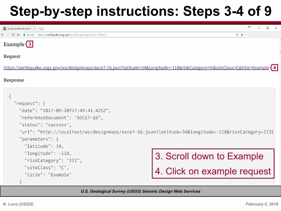
Step-by-step instructions: Steps 5d-6 of 9 5
5d. Still in address bar, change title to that of interest; for example, change Example to Los Angeles, CA
6. Press enter button on your keyboard
U.S. Geological Survey (USGS) Seismic Design Web Services
N. Luco (USGS) February 5, 2018

/ II! https:// eart hquake.usgs. x
~------------------------------------------~
{
C O i Secure I https://ea rthquake.u sgs.go v/ws/designmaps/asce7-16json?latitude=34.05&1ongitude=-118.25&riskCategory= ll&siteClass=D-default&title= Los%20Angeles,%20CA
"request": { "date": "2018-02-12T14: 03: 06. 925Z", "referenceDocument": "ASCE7-16", "status": "success", "url": "https: //earthquake. usgs. gov /ws/ designmaps/asce7-16. j son?
latitude=34.05&longitude=-118.25&riskCategory=II&siteClass=Ddefault&title=Los%20Angeles,%20CA",
"parameters": {
} },
"latitude": 34.05, "longitude": -118.25, "riskCategory": "II", 0 "siteClass": "D-default", "title": "Los Angeles, CA"
"response": { "data": {
"pgauh": 0.844, "pgad" : 0. 998, II pga II : 0 o 844 J
"fpga": 1.2, "pgam": 1. 012, "ssrt": 1.97, "crs": 0 . 898,
0,. * A ['.jl X
EERI Seminar on Next Generation Attenuation Models
Step-by-step instructions: Step 7 of 9
7
U.S. Geological Survey (USGS) Seismic Design Web Services
7. Check that requested parameter values are those you entered
N. Luco (USGS) February 5, 2018
/ II! https:// eart hquake.usgs. x
~----------------------------------------------------~ C O i Secure I https://ea rthquake.u sgs.go v/ws/designmaps/asce7-16json?latitude=34.05&1ongitude=-118.25&riskCategory= ll&siteClass=D-default&title= Los%20Angeles,%20CA
"response": { "data": { 0
"pgauh": 0.844, "pgad" : 0. 998, II pga II : 0 • 844 J
"fpga": 1.2, "pgam": 1. 012, "ssrt": 1.97, "crs": 0 . 898, "ssuh": 2.193, "ssd": 2 .467,
"ss": 1.97, } "fa": 1.2, 0 "sms": 2 . 364, "sds": 1.576, "sdcs": "D", "slrt": 0.701, "crl": 0 . 898, "sluh": 0.781, "sld": 0 . 786, "sl": 0.701, "fv": null, "fv_note": "See Section 11.4.8 ", "sml": null, "sdl": null, "crlr1" · n11l l
0,. * A X
EERI Seminar on Next Generation Attenuation Models
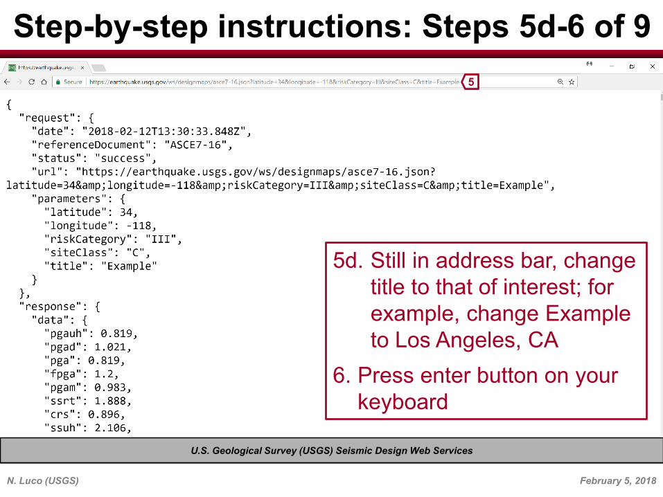
Step-by-step instructions: Steps 8-9 of 9
8
9
8. Scroll down to response data
9. Read SS, Fa, SMS, SDS, etc (see documentation for parameter definitions)
U.S. Geological Survey (USGS) Seismic Design Web Services
N. Luco (USGS) March 5, 2018