Status for Development of Activity Data and Detecting Degradation of Forest in Laos June 17th 2015...
26
Status for Development of Activity Data and Detecting Degradation of Forest in Laos June 17th 2015 Dr. Ryota KAJIWARA Kokusai Kogyo Co., Ltd. NFIS and FPP Project in Laos
-
Upload
nathan-houston -
Category
Documents
-
view
217 -
download
2
Transcript of Status for Development of Activity Data and Detecting Degradation of Forest in Laos June 17th 2015...
Status for Development of Activity Data and Detecting Degradation of Forest
in Laos
June 17th 2015
Dr. Ryota KAJIWARAKokusai Kogyo Co., Ltd.NFIS and FPP Project in Laos
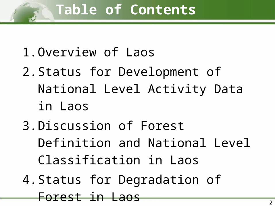
1. Overview of Laos
2. Status for Development of National Level Activity Data in Laos
3. Discussion of Forest Definition and National Level Classification in Laos
4. Status for Degradation of Forest in Laos
5. Summary
Table of Contents
2

1. Overview of Laos
3
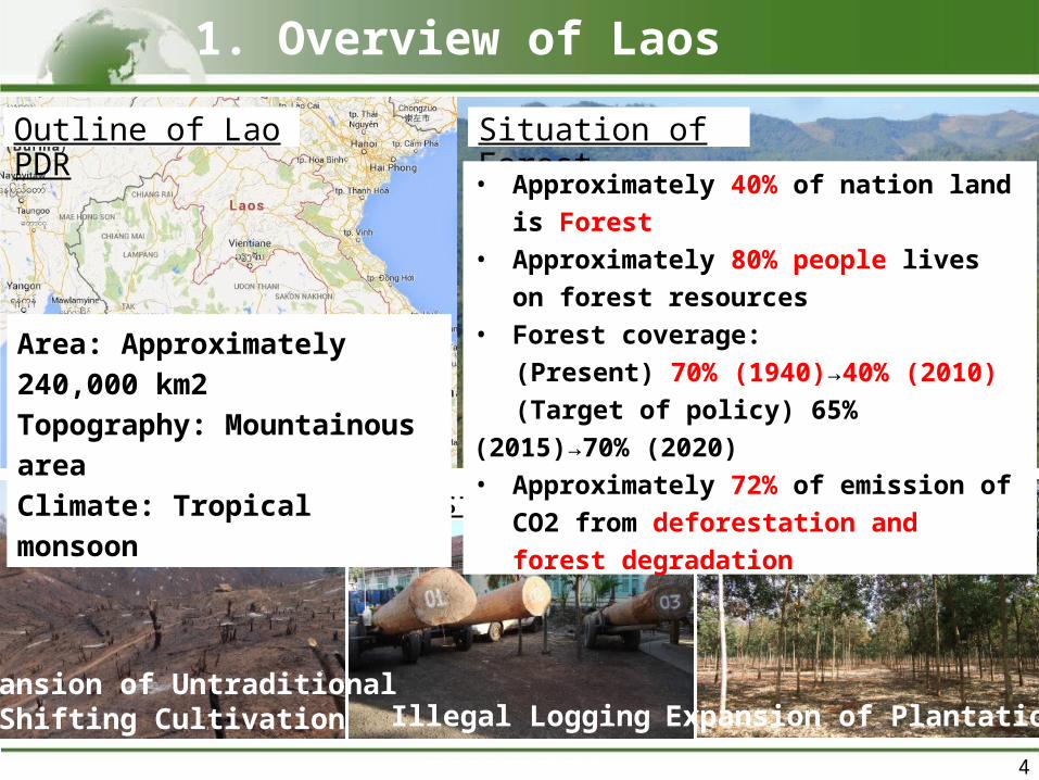
Outline of Lao PDR
4
Main Drivers of Deforestation and Forest Degradation
Area: Approximately 240,000 km2Topography: Mountainous areaClimate: Tropical monsoon
Expansion of UntraditionalShifting Cultivation Illegal Logging Expansion of Plantation
Situation of Forest• Approximately 40% of nation land
is Forest• Approximately 80% people lives
on forest resources• Forest coverage:
(Present) 70% (1940)→40% (2010)(Target of policy) 65% (2015)→70%
(2020)• Approximately 72% of emission of
CO2 from deforestation and forest degradation
1. Overview of Laos
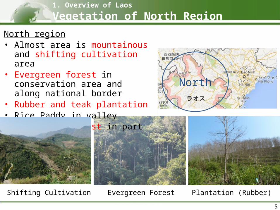
North region• Almost area is mountainous
and shifting cultivation area• Evergreen forest in
conservation area and along national border
• Rubber and teak plantation• Rice Paddy in valley• Coniferous forest in part of
area
North
Shifting Cultivation Evergreen Forest Plantation (Rubber)
5
1. Overview of Laos
Vegetation of North Region
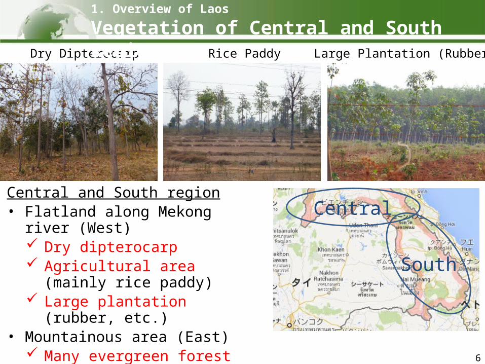
Central and South region• Flatland along Mekong river
(West) Dry dipterocarp Agricultural area (mainly rice
paddy) Large plantation (rubber,
etc.)• Mountainous area (East)
Many evergreen forest Some shifting cultivation
South
Central
Dry Dipterocarp Rice Paddy Large Plantation (Rubber)
6
1. Overview of Laos
Vegetation of Central and South Region
2. Status for Development of National Level Activity Data in Laos
7
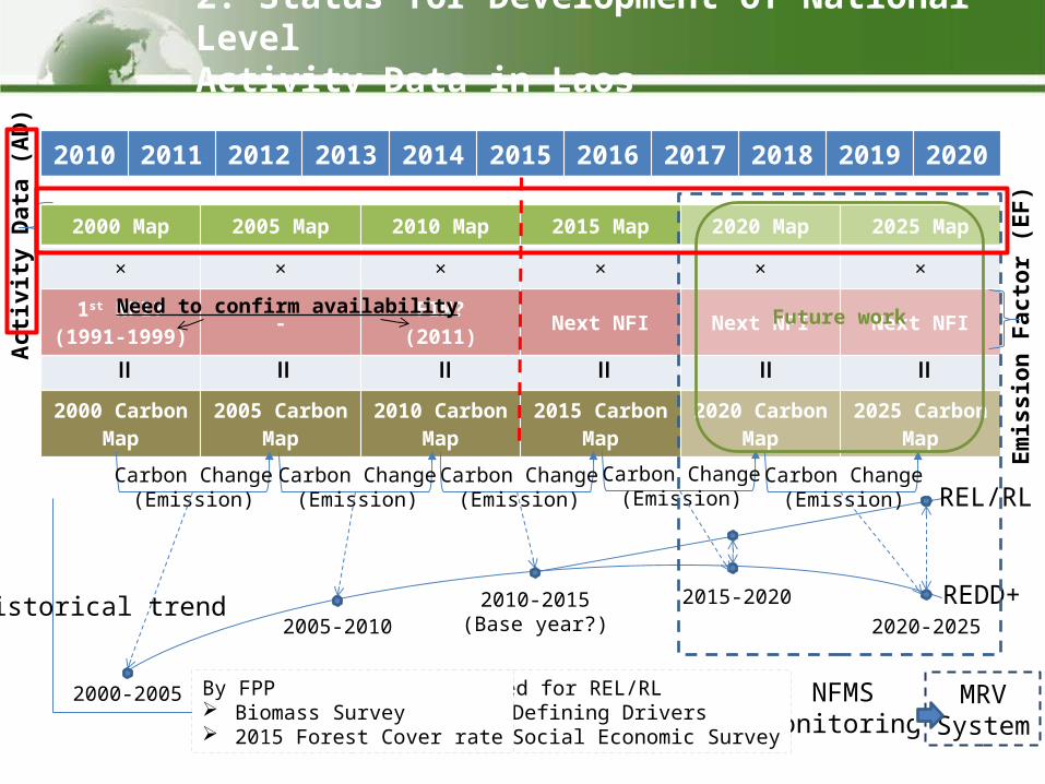
2000 Map 2005 Map 2010 Map 2015 Map 2020 Map 2025 Map
× × × × × ×
1st NFI?(1991-1999)
-FIM?
(2011)Next NFI Next NFI Next NFI
2000 Carbon Map
2005 Carbon Map
2010 Carbon Map
2015 Carbon Map
2020 Carbon Map
2025 Carbon Map
Historical trend
2010
2011
2012
2013
2014
2015
2016
2017
2018
2019
2020
Em
issio
n F
acto
r (E
F)
Acti
vit
y D
ata
(A
D)
Carbon Change(Emission)
Carbon Change(Emission)
Carbon Change(Emission)
2000-2005
2005-20102010-2015
(Base year?)
REL/RL
REDD+2015-2020
2020-2025
Carbon Change(Emission)
Carbon Change(Emission)
NFMS(Monitoring)
Need for REL/RL Defining Drivers Social Economic Survey
MRVSystem
By FPP Biomass Survey 2015 Forest Cover rate
======
Future workNeed to confirm availability
2. Status for Development of National Level Activity Data in Laos
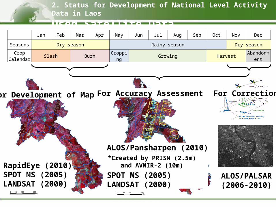
ALOS/Pansharpen (2010)
SPOT MS (2005)LANDSAT (2000)
RapidEye (2010)SPOT MS (2005)LANDSAT (2000)
*Created by PRISM (2.5m)and AVNIR-2 (10m)
Jan Feb Mar Apr May Jun Jul Aug Sep Oct Nov Dec
Seasons Dry season Rainy season Dry season
Crop Calendar
Slash BurnCroppin
gGrowing Harvest
Abandonment
ALOS/PALSAR(2006-2010)
For Accuracy AssessmentFor Development of Map For Correction
2. Status for Development of National Level Activity Data in Laos
Used Satellite Data
10
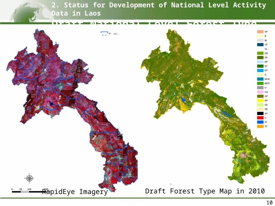
RapidEye Imagery Draft Forest Type Map in 2010
2. Status for Development of National Level Activity Data in Laos
Draft National Level Forest Type Map in 2010
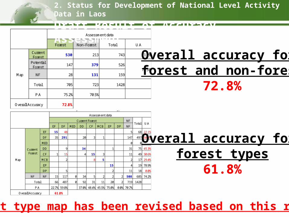
Forest Non- Forest Total U.A
CurrentForest
530 213 743 71.3%
PotentialForest
147 379 526
NF 28 131 159
Total 705 723 1428
P.A 75.2% 70.5%
72.8%
74.5%
Overall Accuracy
Map
Assessment data
NF
EF DF MED DD CF MCB EP DP NF
EF 15 48 5 68 22.1%
DF 35 291 20 3 1 147 497 58.6%
MED 0 0
DD 9 34 1 31 75 45.3%
CF 1 15 4 15 3 11 49 30.6%
MCB 2 8 5 2 17 29.4%
EP 15 4 19 78.9%
DP 5 2 11 18 0.0%
NF NF 15 117 0 34 5 2 2 2 508 685 74.2%
66 487 0 92 31 11 20 2 719 1428
22.7% 59.8% 37.0% 48.4% 45.5% 75.0% 0.0% 70.7%
Draft Result of Accuracy Assessment for Forest Type
Assessment data
Current ForestTotal U.A
61.8%
Map
Current Forest
Total
P.A
Overall Accuracy
Overall accuracy for forest and non-forest
72.8%
Overall accuracy for forest types
61.8%
2. Status for Development of National Level Activity Data in Laos
Draft Result of Accuracy Assessment
Forest type map has been revised based on this result
3. Discussion of Forest Definition and National Level Classification
in Laos
12
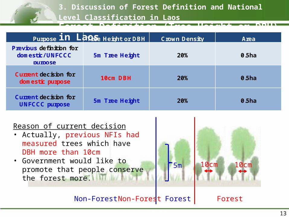
Purpose Tree Height or DBH Crown Density Area
Previous definition fordomestic/ UNFCCC
purpose5m Tree Height 20% 0.5ha
Current decision fordomestic purpose
10cm DBH 20% 0.5ha
Current decision forUNFCCC purpose
5m Tree Height 20% 0.5ha
13
3. Discussion of Forest Definition and National Level Classification in LaosForest Definition (Tree Height or DBH) in Laos
ForestNon-Forest
5m 10cm
ForestNon-Forest
Reason of current decision• Actually, previous NFIs had
measured trees which have DBH more than 10cm
• Government would like to promote that people conserve the forest more.
10cm
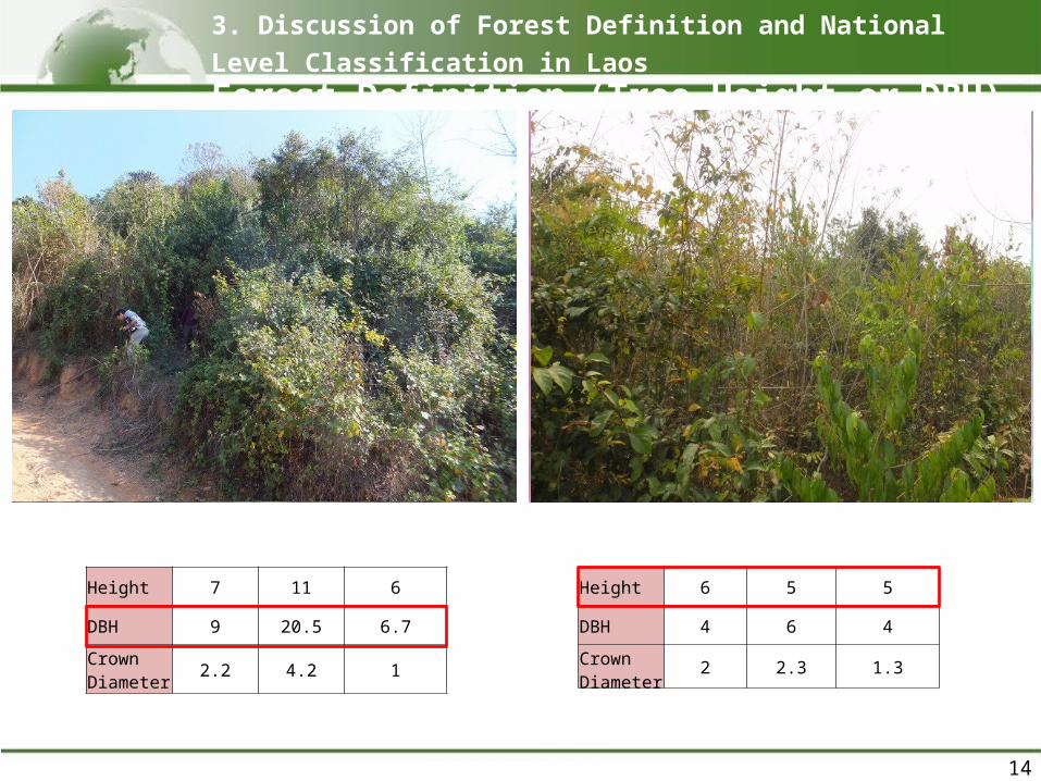
Height 7 11 6
DBH 9 20.5 6.7
Crown Diameter
2.2 4.2 1
14
RapidEye (5m)
3. Discussion of Forest Definition and National Level Classification in LaosForest Definition (Tree Height or DBH) in Laos
Height 6 5 5
DBH 4 6 4
Crown Diameter
2 2.3 1.3
RapidEye (5m)
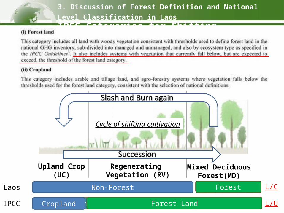
IPCC
Laos Non-Forest Forest L/C
L/UCropland? or Forest Land? Forest LandCropland Forest Land
3. Discussion of Forest Definition and National Level Classification in LaosIPCC Categories for Shifting Cultivation in Laos
Upland Crop(UC)
Regenerating Vegetation (RV)
Mixed DeciduousForest(MD)
Cycle of shifting cultivation
Level 1
Coniferous Forest CF
Mixed Coniferous andBroadleaved Forest
MCB
Bamboo B
Savannah SAScrub SC
Grassland GWetlands Swamp SW
Upland Crop UCRice Paddy RPOther Agriculture OA
Agriculture Plantation APSettlements Urban U
Barren Land and Rock BROther Land Other Land O
Wetlands Water Water W
Non VegetatedAreas
Other Land
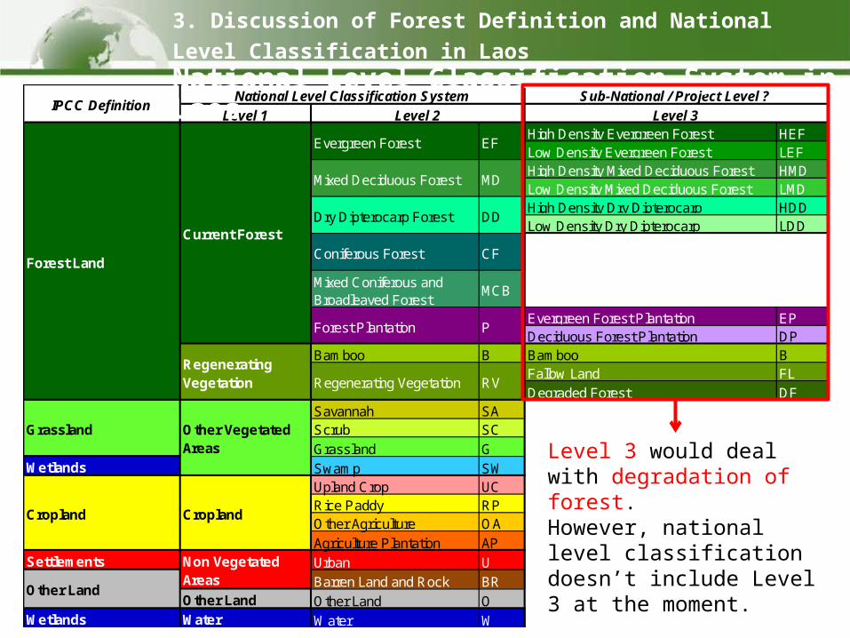
National Level Classification System
RegeneratingVegetation Regenerating Vegetation RV
Grassland Other VegetatedAreas
Cropland Cropland
Forest Land
Current Forest
Evergreen Forest EF
Mixed Deciduous Forest MD
Dry Dipterocarp Forest DD
Forest Plantation P
IPCC DefinitionLevel 2Level 1
High Density Evergreen Forest HEFLow Density Evergreen Forest LEFHigh Density Mixed Deciduous Forest HMDLow Density Mixed Deciduous Forest LMDHigh Density Dry Dipterocarp HDDLow Density Dry Dipterocarp LDD
Coniferous Forest CF
Mixed Coniferous andBroadleaved Forest
MCB
Evergreen Forest Plantation EPDeciduous Forest Plantation DP
Bamboo B Bamboo BFallow Land FL
Degraded Forest DFSavannah SAScrub SC
Grassland GWetlands Swamp SW
Upland Crop UCRice Paddy RPOther Agriculture OA
Agriculture Plantation APSettlements Urban U
Barren Land and Rock BROther Land Other Land O
Wetlands Water Water W
Non VegetatedAreas
Other Land
National Level Classification System Sub-National / Project Level ?
RegeneratingVegetation Regenerating Vegetation RV
Grassland Other VegetatedAreas
Cropland Cropland
Forest Land
Current Forest
Evergreen Forest EF
Mixed Deciduous Forest MD
Dry Dipterocarp Forest DD
Forest Plantation P
IPCC DefinitionLevel 2 Level 3
3. Discussion of Forest Definition and National Level Classification in LaosNational Level Classification System in Laos
Level 3 would deal with degradation of forest.However, national level classification doesn’t include Level 3 at the moment.
4. Status for Degradation of Forest in Laos
17
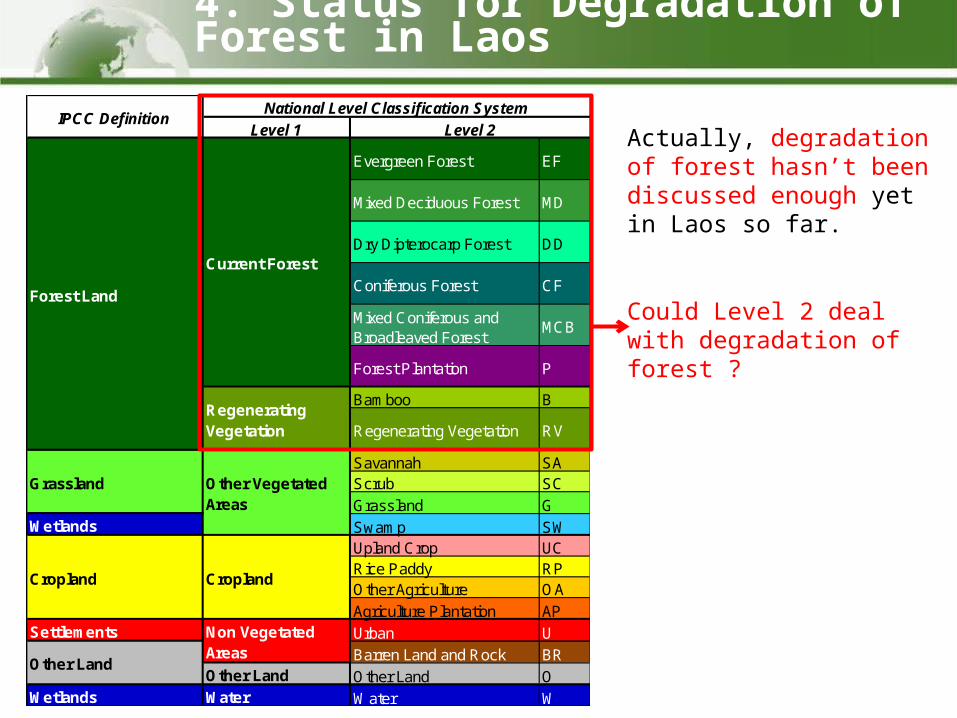
Level 1
Coniferous Forest CF
Mixed Coniferous andBroadleaved Forest
MCB
Bamboo B
Savannah SAScrub SC
Grassland GWetlands Swamp SW
Upland Crop UCRice Paddy RPOther Agriculture OA
Agriculture Plantation APSettlements Urban U
Barren Land and Rock BROther Land Other Land O
Wetlands Water Water W
Non VegetatedAreas
Other Land
National Level Classification System
RegeneratingVegetation Regenerating Vegetation RV
Grassland Other VegetatedAreas
Cropland Cropland
Forest Land
Current Forest
Evergreen Forest EF
Mixed Deciduous Forest MD
Dry Dipterocarp Forest DD
Forest Plantation P
IPCC DefinitionLevel 2 Actually, degradation of
forest hasn’t been discussed enough yet in Laos so far.
Could Level 2 deal with degradation of forest ?
4. Status for Degradation of Forest in Laos
19
Evergreen Forest Regenerating Vegetation(Degraded Forest)
Evergreen Forest/Mixed Deciduous
Forest
UplandCrop
RegeneratingVegetation
(Fallow Land)
Mixed DeciduousForest
Deforestation
Is it Degradation??Is it Degradation??
(in case of EF -> MD)
It may be Degradation
(1) In case of shifting cultivation
(2) In case of logging and fire
Reforestation Enhancement
4. Status for Degradation of Forest in LaosCan Degradation be detected at National Level ?
20
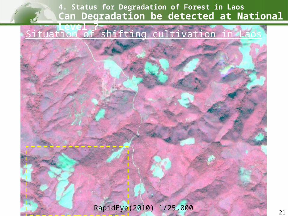
4. Status for Degradation of Forest in LaosCan Degradation be detected at National Level ?
RapidEye(2010) 1/100,000
Situation of shifting cultivation in Laos
21
4. Status for Degradation of Forest in LaosCan Degradation be detected at National Level ?
RapidEye(2010) 1/25,000
Situation of shifting cultivation in Laos
22
4. Status for Degradation of Forest in LaosCan Degradation be detected at National Level ?
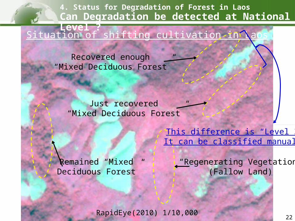
RapidEye(2010) 1/10,000
Situation of shifting cultivation in Laos
Remained “Mixed Deciduous Forest”
Recovered enough “Mixed Deciduous Forest”
Just recovered “Mixed Deciduous Forest”
“Regenerating Vegetation”(Fallow Land)
This difference is “Level 3”.It can be classified manually.
23
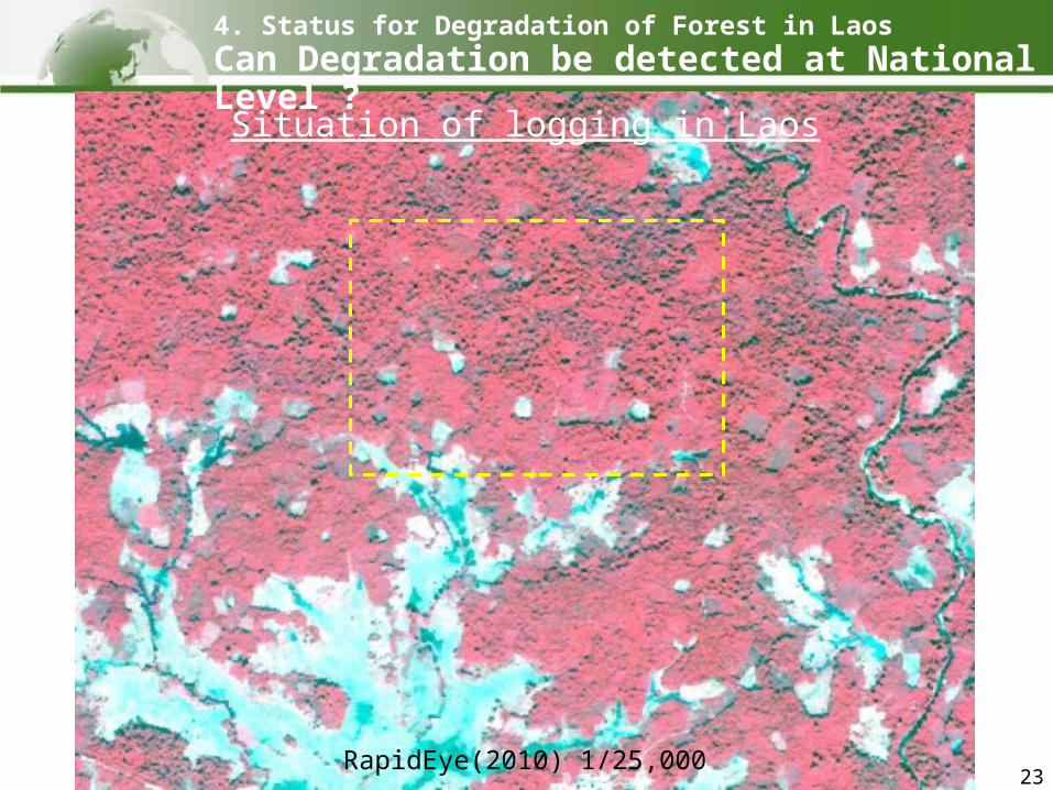
4. Status for Degradation of Forest in LaosCan Degradation be detected at National Level ?
RapidEye(2010) 1/25,000
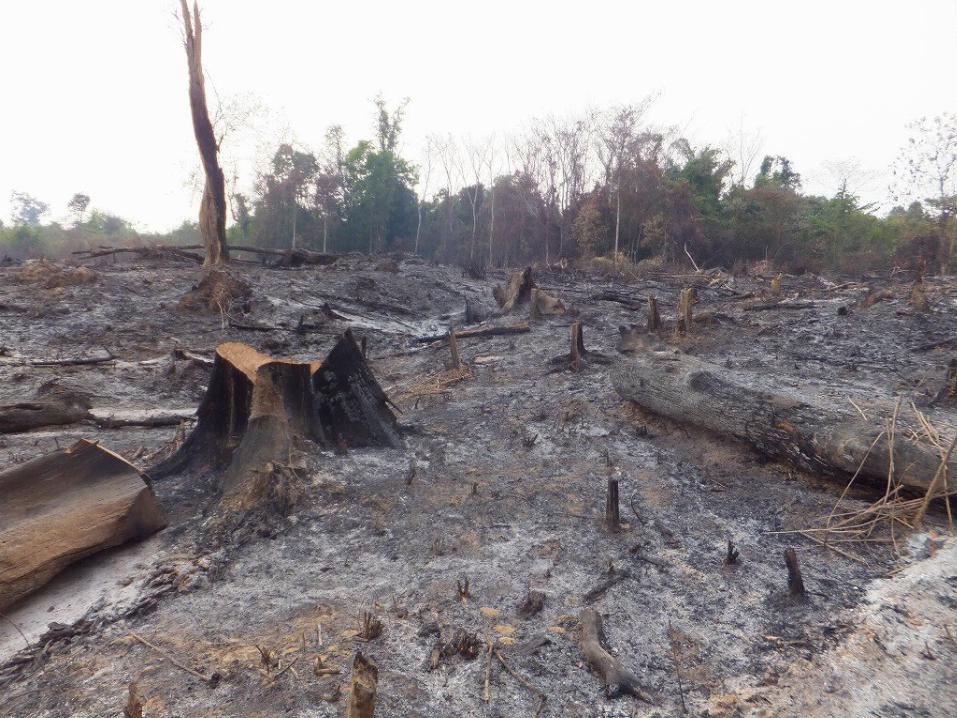
Situation of logging in Laos
24
4. Status for Degradation of Forest in LaosCan Degradation be detected at National Level ?
RapidEye(2010) 1/10,000
Low density “Evergreen Forest”
High density“Evergreen Forest”
“Regenerating Vegetation”(Degraded Forest)
This difference is “Level 3”.It can be classified manually.
Situation of logging in Laos
25
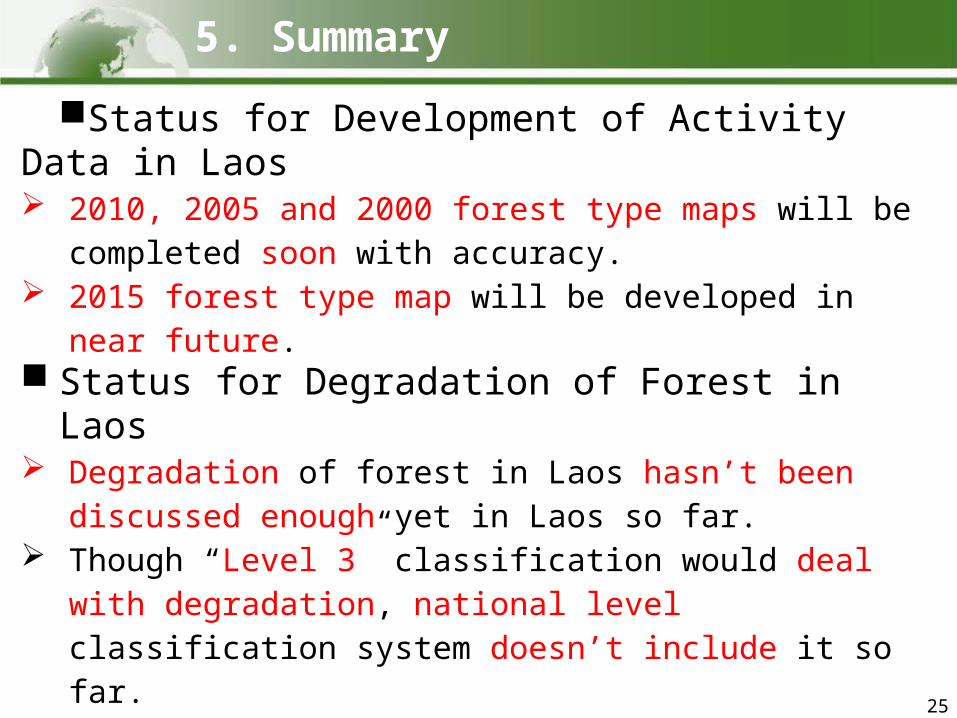
Status for Development of Activity Data in Laos 2010, 2005 and 2000 forest type maps will be
completed soon with accuracy. 2015 forest type map will be developed in near future. Status for Degradation of Forest in Laos Degradation of forest in Laos hasn’t been discussed
enough yet in Laos so far. Though “Level 3” classification would deal with
degradation, national level classification system doesn’t include it so far.
Are degradation in Laos logging, fire and shifting cultivation?
Can we call case of shifting cultivation is degradation? RapidEye(5m) can detect degradation at both Level 2
and 3. However there are some difficulties which are
seasonal, atmospheric, topographic and cost for remote sensing still.
5. Summary

Thank you for your attention!
26with FIPD staff


![[C31] OSS-DB Exam Silver 技術解説セミナー by Ryota Watabe](https://static.fdocuments.net/doc/165x107/547ce24cb37959892b8b514b/c31-oss-db-exam-silver-by-ryota-watabe.jpg)