Statistics Canada Postal Code ... -...
47
Statistics Canada Postal Code Conversion File June 2001 Postal Codes Reference Guide
Transcript of Statistics Canada Postal Code ... -...

Statistics Canada
Postal Code Conversion FileJune 2001 Postal CodesReference Guide

Data in many forms
Statistics Canada disseminates data in a variety of forms. In addition to publications, both standard and specialtabulations are offered. Data are available on the Internet, compact disc, diskette, computer printouts, microfiche andmicrofilm, and magnetic tape. Maps and other geographic materials are available for some types of data.
How to obtain more information
Inquiries about this product and related statistics or services should be directed to the Statistics Canada RegionalReference Centre in:
Halifax (902) 426-5331 Regina (306) 780-5405Montréal (514) 283-5725 Edmonton (403) 495-3027Ottawa (613) 951-8116 Calgary (403) 292-6717Toronto (416) 973-6586 Vancouver (604) 666-3691Winnipeg(204) 983-4020
You can also visit our World Wide Web site: http://www.statcan.ca
Toll-free access is provided for all users who reside outside the local dialing area of any of the RegionalReference Centres.
National enquiries line 1 800 263-1136National telecommunications device for the hearing impaired 1 800 363-7629Order-only line (Canada and United States) 1 800 267-6677
Standards of service to the public
Statistics Canada is committed to serving its clients in a prompt, reliable and courteous manner and in the officiallanguage of their choice. To this end, the agency has developed standards of service which its employees observe inserving its clients. To obtain a copy of these service standards, please contact your nearest Statistics CanadaRegional Reference Centre.

Statistics Canada
Postal Code Conversion FileJune 2001 Postal Codes
Reference Guide
Published by authority of the Ministerresponsible for Statistics Canada
© Minister of Industry, 1999
All rights reserved. No part of this product may be reproduced,stored in a retrieval system or transmitted in any form or by anymeans, electronic, mechanical, photocopying, recording orotherwise without prior written permission from Licence Services,Marketing Division, Statistics Canada, Ottawa, Ontario, CanadaK1A 0T6.
July 2001
Reference Guide for Catalogue 92F0027XDB
Ottawa
Note of appreciation
Canada owes the success of its statistical system to a long-standing partnership between Statistics Canada, the citizens ofCanada, its businesses, governments and other institutions.Accurate and timely statistical information could not be producedwithout their continued co-operation and good will.


Table of Contents
Statistics Canada – Cat. No 92F0027XDBPostal Code Conversion File - Reference Guide
i
TABLE OF CONTENTSPage
1. About this guide ..........................................................................................................................................................1
2. Overview......................................................................................................................................................................2
3. About this product ......................................................................................................................................................3
3.1 Content........................................................................................................................................................................33.2 General methodology..................................................................................................................................................43.3 Reference date.............................................................................................................................................................43.4 Limitations ..................................................................................................................................................................5
3.4.1 Multiple records..................................................................................................................................................53.4.2 Mailing address versus physical location ...........................................................................................................5
4. Data quality .................................................................................................................................................................7
4.1 Lineage........................................................................................................................................................................74.1.1 Postal code to EA links - Ongoing updates (sources) ........................................................................................74.1.2 Postal code to EA links - Ongoing updates (process) ........................................................................................74.1.3 Update from 1991 to 1996 Census Geography (sources)...................................................................................84.1.4 Update from 1991 to 1996 Census Geography (process)...................................................................................8
4.2 Positional accuracy ...................................................................................................................................................114.2.1 Accuracy of the linkages ..................................................................................................................................114.2.2 Accuracy of the geographic co-ordinates .........................................................................................................11
4.3 Attribute accuracy.....................................................................................................................................................124.4 Logical consistency...................................................................................................................................................124.5 Consistency with other products...............................................................................................................................134.6 Completeness ............................................................................................................................................................13
5. Technical specifications............................................................................................................................................15
5.1 System requirements.................................................................................................................................................155.2 Record layout ............................................................................................................................................................155.3 Name files .................................................................................................................................................................175.4 Field description .......................................................................................................................................................18
6. Glossary .....................................................................................................................................................................23
Appendix A. Hierarchy of national, metropolitan and postal code geographic units...........................................28
Appendix B. Structure of the postal code..................................................................................................................29
Appendix C. Census subdivision types by province and territory, 1996.................................................................30
Appendix D. Representative points ............................................................................................................................31
References......................................................................................................................................................................32
Limited use data product licence agreement..............................................................................................................33
Geography products and services ...............................................................................................................................34


About this guide
Statistics Canada – Cat. No 92F0027XDBPostal Code Conversion File - Reference Guide
1
1. About this guide
This reference guide was prepared to accompany the Postal Code Conversion File (PCCF), (Catalogue No.92F0027XDB). It provides general information about the PCCF, including a description and the generalmethodology used to create it.
The Data Quality section gives a detailed description of the various steps in the creation of the PCCF. This statementalso provides information to evaluate the suitability of the data for a particular use.
A record layout and field descriptions are provided in the Technical Specifications section.
Geographic terms and concepts highlighted in bold in the text are described in the glossary. More details can befound in the 1996 Census Dictionary, Catalogue No. 92-351-XPE. Supplementary information is provided in theappendices and a list of related products and services is also included.
This reference guide is based on the best information available at the time of its release. It in no way constitutes awarranty of the data in the event that users may observe characteristics that deviate from those stated in thisdocument. All efforts have been made to ensure that the verification of this product has been thoroughly done,however, there is no guarantee that the data are 100% accurate. For further information see Section 4, Data Quality.

Overview
Statistics Canada – Cat. No.92F0027XDBPostal Code Conversion File - Reference Guide
2
2. Overview
The Postal Code Conversion File (PCCF) is a digital file, which provides a correspondence between the six characterpostal code and Statistics Canada's standard geographical areas for which census data and other statistics areproduced. Through the link between postal codes and standard geographic areas, the PCCF permits the integration ofdata from various sources.
The geographic co-ordinates attached to each postal code on the PCCF are commonly used to map the distribution ofdata for spatial analysis (e.g., clients, activities). The location information is a powerful tool for marketing, planning,or research purposes.
In April 1983, the Geography Division released the first version of the PCCF, which linked postal codes to censusgeographic areas and included geographic co-ordinates. Since then, the file has been updated on a regular basis tokeep up with postal code changes provided by Canada Post Corporation.
Every five years, the postal code linkages on the PCCF are “converted” to the latest census geographic areas. Theoriginal PCCF was linked to the 1981 Census geographic areas. Since then, the PCCF has undergone three“conversions”, following the 1986, 1991 and 1996 censuses. An automated system was developed for the 1991-1996conversion. Also, for the first time, the 1996 Census reported postal codes were used to validate the PCCF links.
About this product
Statistics Canada – Cat. No 92F0027XDBPostal Code Conversion File - Reference Guide
3
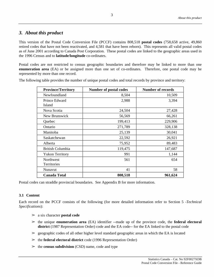
3. About this product
This version of the Postal Code Conversion File (PCCF) contains 808,518 postal codes (758,658 active, 49,860retired codes that have not been reactivated, and 4,581 that have been reborn). This represents all valid postal codesas of June 2001 according to Canada Post Corporation. These postal codes are linked to the geographic areas used inthe 1996 Census and to latitude/longitude co-ordinates.
Postal codes are not restricted to census geographic boundaries and therefore may be linked to more than oneenumeration area (EA) or be assigned more than one set of co-ordinates. Therefore, one postal code may berepresented by more than one record.
The following table provides the number of unique postal codes and total records by province and territory:
Province/Territory Number of postal codes Number of recordsNewfoundland 8,504 10,509Prince EdwardIsland
2,988 3,394
Nova Scotia 24,504 27,428New Brunswick 56,569 66,261Quebec 199,413 229,906Ontario 271,789 328,138Manitoba 25,139 30,041Saskatchewan 22,592 26,921Alberta 75,952 89,483British Columbia 119,475 147,687Yukon Territory 991 1,144NorthwestTerritories
561 654
Nunavut 41 58Canada Total 808,518 961,624
Postal codes can straddle provincial boundaries. See Appendix B for more information.
3.1 Content
Each record on the PCCF consists of the following (for more detailed information refer to Section 5 -TechnicalSpecifications):
â a six character postal code
â the unique enumeration area (EA) identifier --made up of the province code, the federal electoraldistrict (1987 Representation Order) code and the EA code-- for the EA linked to the postal code
â geographic codes of all other higher level standard geographic areas in which the EA is located
â the federal electoral district code (1996 Representation Order)
â the census subdivision (CSD) name, code and type

About this product
Statistics Canada – Cat. No.92F0027XDBPostal Code Conversion File - Reference Guide
4
â latitude/longitude co-ordinates representing approximate point location for the postal code
â Canada Post Corporation (CPC) information relevant to each postal code - its birth date, retirement date,type of mail delivery, and CPC community name
â various flags : single link indicator, type of representation point, EA type, and postal code type
Purchasers of the PCCF also receive supplementary “Names” files. Due to the size of the name fields, and because oftheir repetition, the names are provided on separate files:
â Census Division Names File (CD96.DAT)
â Federal Electoral District Names File - 1996 Representation Order (FED96.DAT)
â Census Metropolitan Area/Census Agglomeration Names File (CMACA96.DAT)
â Primary CMA/Primary CA Names File (PCMAPCA96.DAT)
The basic link between the postal code and other standard census geographic areas is made through one or more 1996enumeration areas (EA). The geographic areas contained on the PCCF are shown on the hierarchy chart providedas Appendix A.
Federal electoral district (1996 Representation Order) codes are also included, however, they are not a standardgeographic area for the 1996 Census.
Postal codes can be linked to Nunavut on the PCCF through the new Federal Electoral District of Nunavut(FED96uid = 62001).
3.2 General methodology
The Postal Code Conversion File is updated on a regular basis and is released every six months. The regularmaintenance of the file takes the postal code changes continually introduced by Canada Post Corporation (CPC) andfinds the corresponding census geographic areas. Every five years, after each census, the PCCF must be re-based tothe new census geographic areas.
CPC provides Statistics Canada with a file every month containing the latest postal codes, address ranges and otherattributes (e.g., delivery mode type). The address information is used to determine the location or the extent of agiven postal code and relate it to the latest enumeration area boundaries. Within major urban areas, postal codeaddress ranges are linked to a digital street network maintained by Statistics Canada, and wherever possible, a block-face link is identified. Municipality maps are used where necessary and as a last resort, contact is made with localauthorities to get as precise a street location as possible. The relationship to enumeration area (EA) is thendetermined by referring to the enumeration area census collection maps to find the same street. All other postal codelinks to geographic areas are derived through the EA.
3.3 Reference date
The geographic reference date is a date determined by Statistics Canada for the purpose of finalizing the geographicframework for which census data will be collected, tabulated and reported. For the 1996 Census geographic areas,the reference date is January 1, 1996.

About this product
Statistics Canada – Cat. No 92F0027XDBPostal Code Conversion File - Reference Guide
5
The reference date for postal codes contained in the Postal Code Conversion File is documented with each release.
3.4 Limitations
3.4.1 Multiple records
The postal code conversion file contains multiple records for a postal code when the postal code straddles more thanone block-face or enumeration area. Multiple records are quite common for rural postal codes and communitymailboxes.
â Rural postal codes are defined in terms of rural routes which are not explicitly attached to dwellings as are civicaddress ranges. These routes tend to straddle several enumeration areas, often crossing boundaries of standardgeographic areas such as census tracts or census subdivisions. It is difficult, if not impossible, to identify aprecise physical location based on a rural postal code.
â Community mail boxes are a growing source for multiple records on the PCCF. In new urban delivery areas,postal codes are assigned to a community mailbox that may cover partial blocks, both sides of a street anddifferent streets within a 300 metre radius. These situations often result in multiple links being establishedbetween the postal code and block-faces, unlike the more traditional urban postal codes, which correspondgenerally to a block-face.
The “single link indicator” was created to assist users in dealing with multiple records. The method used to establishthe single link indicator attempts to identify the geographic area with the majority of dwellings using the particularpostal code. Users should be cautioned that only a partial correspondence between the postal code and othergeographic areas is achieved when using the single link indicator.
The following table presents the number of postal codes (including retired postal codes) showing the occurrence ofmultiple links for selected geographic areas.
Geographic area Postal codes withmultiple links
Enumeration area 44,366
Census tract 8,889
Census subdivision (municipality) 6,944
Census division 1,166
Census metropolitan area 1,146
Province/Territory 10
3.4.2 Mailing address versus physical location
The address associated with a postal code does not always represent the location of those receiving mail using thatpostal code. This is particularly the case in rural areas, where rural route service and post office pick-up arecommonly used to deliver mail. Postal codes that are usually considered rural are identified by the delivery modetype of “W” (rural) and “H” (rural route) on the PCCF.
A typical rural route address, such as "RR#3 Caledon, Ontario", does not provide sufficient address information toidentify a precise physical location. A rural post office address such as "Box 11200, Stn. H" is also imprecise and not

About this product
Statistics Canada – Cat. No.92F0027XDBPostal Code Conversion File - Reference Guide
6
explicitly attached to the dwellings served by that postal code. Consequently, rural postal codes can not be used inthe same manner as most urban postal codes can to precisely geo-reference a physical location.
Similarly, postal codes with a delivery mode type “K” (group of post office boxes) or “M” (one post office box) aregenerally linked to the location of the post office on the PCCF, as opposed to the physical location of customers whorent a post office box.
Where the census information has indicated a significant number of households located within an enumeration areawho share a postal code, these have been added to better represent the population distribution for these types ofpostal codes.

Data quality
Statistics Canada – Cat. No 92F0027XDBPostal Code Conversion File - Reference Guide
7
4. Data quality
The purpose of this data quality statement is to provide detailed information so that users may evaluate the suitabilityof the data for their use. Five fundamental components of a data quality statement are: lineage, positional accuracy,attribute accuracy, logical consistency and completeness. (See Statistics Canada, 1992.)
4.1 Lineage
Lineage includes descriptions of the source material from which the data were derived and the methods ofderivation, including the dates of the source material and all transformations involved in producing the final PostalCode Conversion File product.
The PCCF is the result of two updating activities. One is the ongoing maintenance activity which links the latestpostal codes from Canada Post Corporation to census geographic areas. These links are continuously recorded on theGeography Division’s postal code data base. The other update activity is done every five years, after each census, tore-link the data base to the latest census geographic areas.
4.1.1 Postal code to EA links - Ongoing updates (sources)
The sources used to keep up with ongoing postal code updates are:
â Canada Post Corporation Address look-up file and auxiliary files,
â in-house digital Street Network Files (SNF),
â enumeration area collection maps,
â maps provided by other sources (e.g., municipalities), and
â telephone contact with local authorities.
4.1.2 Postal code to EA links - Ongoing updates (process)
The procedures for linking postal codes to census geographic areas depend on whether the postal code is locatedwithin or outside the areas covered by Street Network Files (SNF).
In areas covered by digital street network files, an attempt is made to link postal codes to one or more block-faces.The list of new postal code and address range records from Canada Post Corporation (CPC) is matched to the SNFstreet listings according to elements common to both files, i.e., province, municipality, street name, type, directionand address range.
Once matched, the postal code, province code, enumeration area code and block-face representative point aretransferred to the postal code data base.
For those postal codes in SNF areas that cannot be coded by the above method, and for all other urban postal codes innon-SNF areas, municipal maps are used to find the street(s). When a street is found, the same street is located on aCensus collection map and the address range is then used to link to the EA or, if available on the SNF, to the block-face representative point(s) for that postal code.

Data quality
Statistics Canada – Cat. No.92F0027XDBPostal Code Conversion File - Reference Guide
8
If a street cannot be found on a municipal map, local authorities (such as Planning and Engineering Departments andlocal post offices) are contacted to assist in the location of the street. In areas experiencing growth, new maps arerequested from the proper authority. After the street is located, Census collection maps are used to determine theenumeration area.
Rural postal codes
A rural postal code denotes an area serviced by rural route delivery from a post office or postal station. A zero (0) inthe second position of the postal code identifies a rural postal code. Such an area can cross several geographicboundaries. The 1991 and 1996 Census collection documents are used to help determine these service areas.
Post Office Addresses
In some cases, the ultimate destination of mail delivery is not the same as the pick-up point. For example, in urbanareas postal codes may be associated with post office boxes at a postal station. In these cases, the geographic link forthe postal code provided by the Postal Code Conversion File (PCCF) identifies the location of the post office ratherthan the residential, industrial or commercial location of the client renting a post office box.
4.1.3 Update from 1991 to 1996 Census Geography (sources)
The sources used to update the census geography linkage from 1991 to 1996 were:
ã May 1998 postal codes and address range information from Canada Post Corporation,
ã 1996 block face and representative points data file,
ã 1991-1996 enumeration area correspondence file,
ã 1996 enumeration area digital cartographic files,
ã 1996 federal electoral district digital cartographic file, and,
ã 1996 Census reported postal code data.
4.1.4 Update from 1991 to 1996 Census Geography (process)
The method used to bring the PCCF from 1991 to 1996 Census geographic links is somewhat different from previousconversions. The steps can be summarized as follows:
1. Automated address range matching
2. Assigning 1996 EA using 1991 links
3. Validating and changing preliminary conversion results using 1996 Census data
4. Adding ‘historic’ block-face representative points
5. Assigning the Federal Electoral District (1996 Representation Order) code
6. Assigning the single link indicator to flag the “best” record for each postal code.

Data quality
Statistics Canada – Cat. No 92F0027XDBPostal Code Conversion File - Reference Guide
9
Step 1. Automated address range matching
This conversion used a new approach to link current postal codes to the 1996 Census geography. For the first time,address range information from Canada Post Corporation was used to find an associated block-face and enumerationarea link directly on the 1996 Street Network Files (SNF). Where this was successful, block-face representativepoint(s) and enumeration area links were generated without any reference to the 1991 linkages assigned previously tothe same postal code.
Step 2. Assigning 1996 EA using 1991 links
Where a match could not be found through the automated address matching system, two methods were used toconvert from 1991 to 1996 EAs:
1. 1991-1996 EA correspondence file; and,
2. point-in-polygon process
EA correspondence file: The correspondence file shows the relationship between 1991 EAs and 1996 EAs. Sixtypercent (60%) of enumeration areas did not change between 1991 and 1996. For all postal codes linked to these EAs,the conversion process kept the equivalent 1996 EA. Where EA boundaries changed between 1991 and 1996 (40% ofall enumeration areas), the EA correspondence file created a link to all EAs involved in the change. This process wasused in the two previous conversions and is known to introduce a number of questionable links to the PCCF. For thefirst time, census data were used to validate or reject some of these links.
Point-in-polygon: The 1991 enumeration area (EA) representative points in conjunction with the 1996 EA digitalcartographic file were used (a point-in-polygon process) to bring the postal codes linked to 1991 EAs to theircorresponding 1996 EAs. This method was used to identify valid links and limit the extraneous links produced by thecorrespondence file.
Step 3. Validating and changing preliminary conversion results using the 1996 Census data
The relationship between the postal code and EAs as reported by the 1996 Census was used to confirm and to modifypostal code to EA linkages created through the automated Step 1 and 2 above. Postal codes reported in the Census donot represent the entire universe of postal codes. Also, the postal codes reported in the census may represent alocation other than that of a respondent’s usual place of residence, such as work place or post office box. Despitethese limitations, the 1996 Census reported postal codes were considered to be a valuable source for the validation ofpostal code to enumeration area linkages on the PCCF.
There were 605,600 postal code to EA linkages on the PCCF confirmed by the 1996 Census data.
Postal code to EA linkages obtained in Step 1 and 2 but not confirmed by the census data were judged valid if :
â the postal code was linked to a block-face,
â the postal code was not reported in the census (there were 114,915),
â the postal code had a business delivery mode type,
â the postal code to EA link represented the location of a post office.

Data quality
Statistics Canada – Cat. No.92F0027XDBPostal Code Conversion File - Reference Guide
10
Postal code to EA links were added to the PCCF using the 1996 Census reported postal code data if they met one ofthe following criteria:
â most people reporting the postal code lived in that EA,
â most people in the EA reported the postal code,
â a large population or a large number of households reported the postal code within the EA.
Another 28467 links were added to the PCCF using these criteria.
Step 4. Adding ‘historic’ block-face representative points
To give users the maximum number of block-face level links, co-ordinates for ‘historic’ block-faces were added.These are block-faces present on the 1991 vintage PCCF which were not re-generated using the automated addressmatch between the latest postal code location information from Canada Post and the in-house 1996 Street Networkfiles. Historic block-face level links were extracted based on their positional accuracy relative to the current PCCF,such that they fell within a valid enumeration area for a given postal code.
Step 5. Assigning the Federal Electoral District (1996 Representation Order)
The 1996 Representation Order Federal Electoral Districts (1996 FEDs) were defined by Elections Canada after the1996 Census enumeration areas were delineated for the census taking. As a result, EA boundaries do not respect1996 FED limits. In order to link postal codes to these new FEDs, a boundary overlay (point in polygon) wasperformed. The Federal Electoral District digital cartographic file was overlaid onto the latest postal code co-ordinates. If a postal code had multiple co-ordinates (linked to more than one EA) falling into more than one federalelectoral district, the PCCF assigns that postal code to all relevant FEDs.
Step 6. Assigning the single link indicator
Many postal codes are represented by multiple records on the PCCF. This can become problematic for someapplications and therefore, a flag identifying a “single” link for each postal code has been created. The single linkindicator was previously referred to as the single postal code indicator.
The single link indicator has the value “1” to flag the “best” (or only) link for a given postal code. The value “0”indicates an additional record.
The method used to assign the single link indicator has been influenced by the use of 1996 Census reported postalcode data. Where 1996 Census data are available, postal codes with multiple links now have their single linkindicator assigned to the enumeration area with the highest population reporting that postal code.
Otherwise, the single link indicator is assigned using the traditional method based on CPC address ranges. For eachaddress range associated with a postal code, the low address is subtracted from the high address. The address rangewith the highest difference is determined and that postal code record is selected as the best link and assigned thevalue “1”. In cases where the postal code spans more than one EA, the address range differences are totalled for each

Data quality
Statistics Canada – Cat. No 92F0027XDBPostal Code Conversion File - Reference Guide
11
EA, and the EA with the highest total difference is selected as the single link indicator.
Users should be cautioned that by using the single link indicator, only a partial correspondence between the postalcode and other geographic areas is achieved.
4.2 Positional accuracy
Positional accuracy is the difference between the “true” position of a feature in the real world and the “estimated”position stored in the Postal Code Conversion File.
The geographic co-ordinates assigned to postal codes are those of either block-face or enumeration arearepresentative points calculated for census purposes. Therefore, the positional accuracy of the postal code isdependent on:
ã the accuracy of the links established between the postal code and the EA or block-face, and
ã the positional accuracy of the EA and block-face representative points with respect to the EA or block-face.
4.2.1 Accuracy of the linkages
The different methods used to create linkages on the PCCF result in varying degrees of accuracy for those linkages.Postal codes linked to block-faces (62% of the total number of records) are considered to be the most accurate, asthey have been linked as close as possible with the address ranges representing the location of the postal codeaccording to Canada Post Corporation. Block-face level links added from previous versions of PCCF (historic block-face) are accurate to the extent that they fall within a valid enumeration area for the postal code.
Where the block-face link could not be produced, postal codes have been linked to enumeration areas.Approximately 66% of the total number of postal code to enumeration area links contained in the PCCF are validatedby 1996 Census data.
There is no further measurement of data quality available to describe the accuracy of the linkages.
4.2.2 Accuracy of the geographic co-ordinates
No measurements of positional accuracy of the representative points were made. Positional accuracy is presentedhere in terms of descriptive statements.
Generally, the block-face geographic co-ordinates are relatively accurate point locators for a postal code. The 1996Street Network files (Statistics Canada) were used to create most of the block-face representative points. Therefore,relative positional accuracy is maximized when the PCCF is used in conjunction with these files.
For those ‘historic’ block-face co-ordinates carried on the file, users should be cautioned that, when used inconjunction with current Street Network files, these points will have varying degrees of accuracy as locationindicators. They are differentiated from the 1996 SNF generated block-faces by the representative point type (i.e.,“1” = 1996 SNF block-face; “4”=historic block-face). Refer to the Technical Specifications section.
Where the block-face link could not be produced, the geographic co-ordinate provided is the enumeration arearepresentative point. While this is much less precise and may not be suitable for small area market studies, it is

Data quality
Statistics Canada – Cat. No.92F0027XDBPostal Code Conversion File - Reference Guide
12
readily available and may give an acceptable level of precision for larger scale studies.
The geographic co-ordinates contained on the PCCF were overlaid on the Enumeration Area Digital CartographicFiles to confirm that virtually all points fall within their respective EA boundaries.
The geographic co-ordinates included on the Postal Code Conversion File are derived from Statistics Canada’s StreetNetwork File, (SNF). Users should be aware that absolute positional accuracy is not an intended feature of the SNF.Consequently, these files and any by-product are not recommended for engineering or legal applications or foremergency dispatching services.
For more information on the method used to calculate representative points for block-faces and EAs, refer toAppendix D.
4.3 Attribute accuracy
Attribute accuracy refers to the accuracy of the non-positional information attached to each postal code.
The PCCF is essentially a flat file giving attributes for postal codes and for the enumeration area(s) linked to thepostal code. Most of these attributes are taken from two independent sources. Some attributes were also created forthe PCCF.
The geographic codes, types and names of all other higher level standard geographic areas in which the EA is locatedare taken from the 1996 Geographic Attribute Database. This database is created and maintained by the GeographyDivision of Statistics Canada. A very small number of linkage errors have been identified on that database since itsfinal certification in the early part of 1997. Due to operational constraints, it is not possible to make the adjustmentsto the database. Information on these errors can be obtained from Statistics Canada.
The information relevant to each postal code -- birth date, retirement date, delivery mode type, type of postal codeand CPC community name - is carried forward from Canada Post Corporation Address look-up file and auxiliaryfiles. In some cases, the postal code type was imputed by Statistics Canada (refer to Section 5. TechnicalSpecifications). The historic delivery mode type was retrieved from historic files maintained by Statistics Canada.
The federal electoral district (1996 Representation Order) was assigned to postal codes in an overlay process, usingthe representative points and the digital FED cartographic file. These digital boundaries may deviate from the exactdescription of the 1996 Representation Order federal electoral district as defined by Elections Canada. However, ithas been demonstrated that the 1991 population counts obtained using these boundaries never differed by more than 1% from the official 1991 population counts.
The single link indicator (refer to section 4.1.4, Step 6) and the type of representative point were assigned byStatistics Canada. No measure of accuracy was made for these fields.
4.4 Logical consistency
Logical consistency is the degree to which features are accurately represented in the data structure and fulfil all theinternal requirements of the data structure. In other words, how well elements of the data structure follow the rulesimposed on them.
In some cases, especially in rural areas, the postal code service areas do not respect EA boundaries. When thisoccurs, the same postal code will be repeated two or more times with different geographical information (i.e.,

Data quality
Statistics Canada – Cat. No 92F0027XDBPostal Code Conversion File - Reference Guide
13
different co-ordinates or EA codes. These multiple records for a postal code reflect the relationship between thepostal code and census geographic areas. Also, a postal code can be linked to more than one block-face within thesame enumeration area.
Conversely, different postal codes could have the same co-ordinate. This happens where more than one postal codehave been linked to the same EA. Also, more than one postal code can be linked to a single block-face.
4.5 Consistency with other products
Data contained on the Postal Code Conversion File are consistent with all 1996 Census related geographic productswith the exception of Postal Code Counts (Cat. No. 92F0086XCB), 1996 Census Forward Sortation Areas DigitalCartographic File (Cat. No. 92F0039XDE), and Postal Code Population Weight File (Cat. No. 93F0040XDB) whichrepresent only the postal codes reported in the 1996 Census and valid as of June 1996. The PCCF provides all postalcodes (both in use and retired) and is updated twice a year to include recent postal codes.
4.6 Completeness
Completeness expresses the degree to which the geographic entities (features) are captured according to the datacapture specifications. It also contains information about selection criteria, definitions used and other relevantmapping rules.
Completeness in the context of the PCCF is the degree to which all valid postal codes are accounted for on the PCCFand all geographic codes from the 1996 Census are linked to a postal code. All postal codes, valid as of June 2001according to Canada Post Corporation, have been linked to census geography. There are 388 populated enumerationareas that are not linked to any postal code on the PCCF. The associated EAs for which there is no postal codelinkages amount to a population of 17,330. There are 614 populated enumeration areas which are not linked to anyactive postal code on the PCCF. These EAs amount to a population of 51,181.


Technical specifications
Statistics Canada – Cat. No 92F0027XDBPostal Code Conversion File - Reference Guide
15
5. Technical specifications
5.1 System requirements
The PCCF does not include any software or instructions on how to use the product within specific GeographicalInformation Systems (GIS) or mapping packages.
5.2 Record layout
The current version of the PCCF includes five files: the "PCCF" file and four "Names" files.
Users familiar with the 1991 version of the PCCF should take note of the following changes, affecting both therecord layout and content:
â The order in which the fields are displayed on the file is changed
â Historic Delivery Mode Type (for retired postal codes or changes in DMT) has been added
â The Delivery Mode Type (DMT) for rural postal codes has been changed from “blank” to “W”
â Single Postal Code Indicator is now called Single Link Indicator
â Designated Place code has been added (new standard geographic area in 1996)
â Year expanded from two (2) to four (4) digits in Birth Date and Retired Date
â The space for Census Subdivision Name has been expanded to ensure the longest names are complete
â Subprovincial regions are now called Economic Regions
The following information is no longer included on the file:
â UTM (Zone, X, Y co-ordinates)
â Statistics Canada Regional Reference Centre code
â Census Tract code (note that CT name remains on the file)

Technical specifications
Statistics Canada – Cat. No.92F0027XDBPostal Code Conversion File - Reference Guide
16
PCCF Record layout
Field Size Position Type AbbreviatedField Name
Description
1 6 1-6 C Postal Code Postal code2 8 7-14 C EAuid Enumeration area unique identifier
3 9 15-23 N Lat Latitude
4 11 24-34 N Long Longitude
5 1 35-35 C SLI Single link indicator
6 2 36-37 C PR Province/territory code
7 4 38-41 C CDuid Census division unique identifier
8 3 42-44 C CSD Census subdivision code
9 57 45-101 C CSDname Census subdivision name
10 3 102-104 C CSDtype Census subdivision type
11 3 105-107 C CCS Census consolidated subdivision code
12 3 108-110 C CMA Census metropolitan area / census agglomeration code
13 1 111-111 C CMAtype Census metropolitan area / census agglomeration type
14 3 112-114 C PCMA Primary census metropolitan area / primary censusagglomeration code
15 1 115-115 C PCMAtype Primary census metropolitan area / primary censusagglomeration type
16 7 116-122 C CTname Census tract name
17 2 123-124 C ER Economic region (ER) code
18 3 125-127 C DPL Designated place (DPL) code
19 5 128-132 C FED96uid Federal electoral district (1996 Representation Order)unique identifier
20 1 133-133 C EAurb_rur Enumeration area urban/rural type
21 1 134-134 C Rep_Point Representative point flag
22 1 135-135 C PCtype Postal code type
23 30 136-165 C Comm_Name Community name
24 1 166-166 C DMT Delivery mode type (DMT)
25 1 167-167 C H_DMT Historic delivery mode type (DMT)
26 8 168-175 C Birth_Date Birth date
27 8 176-183 C Ret_Date Retired date
The field type "N" refers to numeric values while "C" refers to both alphabetic and numeric characters.
Note: A unique identifier is the code that can be used to uniquely identify a geographic area.

Technical specifications
Statistics Canada – Cat. No 92F0027XDBPostal Code Conversion File - Reference Guide
17
5.3 Name files
In order to reduce the size of the PCCF, names for 1996 Representation Order Federal Electoral Districts, CensusDivisions, Census Metropolitan Areas/Census Agglomerations and Primary Census Metropolitan Areas/PrimaryCensus Agglomerations are shown on the following individual Name Files.
1996 Federal Electoral District (FED96) Name FileField Size Position Type Abbreviated
Field NameDescription
1 5 1-5 C FED96 Federal electoral district (1996 RepresentationOrder) unique identifier
2 56 6-61 C EFED96name Federal electoral district (1996 RepresentationOrder) name – English
3 56 62-117 C FFED96name Federal electoral district (1996 RepresentationOrder) name – French
Census Division (CD) Name FileField Size Position Type Abbreviated
Field NameDescription
1 4 1-4 C CDuid Census division (CD) unique identifier
2 46 5-50 C CDname Census division name
Census Metropolitan Area/Census Agglomeration (CMA/CA) Name FileField Size Position Type Abbreviated
Field NameDescription
1 3 1-3 C CMA Census metropolitan area /census agglomeration(CMA/CA) code
2 24 4-27 C CMAname CMA/CA name
Primary Census Metropolitan Area/Primary Census Agglomeration (PCMA/PCA) Name FileField Size Position Type Abbreviated
Field NameDescription
1 3 1-3 C PCMA Primary census metropolitan area /primary censusagglomeration (PCMA/PCA) code
2 25 4-28 C PCMA_Name PCMA/PCA name

Technical specifications
Statistics Canada – Cat. No.92F0027XDBPostal Code Conversion File - Reference Guide
18
5.4 Field description
1 Postal Code
The Canadian postal code offers a unique reference system which provides a means of identifying a mail deliverylocation. It is composed of six characters, in the form of "ANA NAN", where "A" represents a letter of the alphabetand "N" a number. Refer to Appendix B for more information about postal codes.
2 EAuid
Uniquely identifies an enumeration area. The EAuid is composed of the two digit province code, the three digitfederal electoral district code (1987 Representation Order) and the three digit enumeration area code.
3 Lat
This field contains the latitude (in degrees and decimals north of the equator) of the EA or block face representativepoint. The decimal point is explicit.
4 Long
This field contains the longitude (in degrees and decimals west of the prime meridian) of the EA or block facerepresentative point. The decimal point is explicit.
5 SLI
The single link indicator (SLI) can be used to establish a one-to-one relationship between postal codes andenumeration areas or block-face. This field was previously called the Single Postal Code Indicator. The single linkindicator has the following values:
“1” indicates the “best” (or only) record for the postal code;
“0” indicates an additional record for the postal code.
6 PR
Province/territory code.
Province/Territory Code Province/Territory Code
Newfoundland 10 Manitoba 46
Prince Edward Island 11 Saskatchewan 47
Nova Scotia 12 Alberta 48
New Brunswick 13 British Columbia 59
Quebec 24 Yukon Territory 60
Ontario 35 Northwest Territories 61
Nunavut 62
7 CDuid (also in the Census Division Name File)
Uniquely identifies a census division. The first two digits of the CDuid identify the province or territory (PR).Census division names are found in the Census Division Name file.

Technical specifications
Statistics Canada – Cat. No 92F0027XDBPostal Code Conversion File - Reference Guide
19
8 CSD
Identifies a census subdivision (municipality) within a census division. This code should be combined with thecensus division unique identifier (CDuid) to uniquely identify a census subdivision in the country. The province,census division and census subdivision (municipality) codes represent the 1996 Standard Geographical Classification(SGC).
9 CSDname
Contains the name of the census subdivision (municipality) in effect as of January 1, 1996.
10 CSDtype
This field provides abbreviations used to identify the census subdivision (municipality) type. See Appendix D for thecomplete list.
11 CCS
Identifies a census consolidated subdivision within a census division. This code should be combined with the censusdivision unique identifier (CDuid) to uniquely identify a census consolidated subdivision in the country.
12 CMA (also in the Census Metropolitan Area / Census Agglomeration Name file)
Uniquely identifies a census metropolitan area or a census agglomeration. Corresponding names are found in theCensus Metropolitan Area / Census Agglomeration Name file.
13 CMAtype
Identifies the type of census metropolitan area (CMA) or census agglomeration (CA) in which the enumeration areais located. This field will be left blank where the enumeration area is not part of a CMA or CA.
Code CMA/ Type CA
A Consolidated CMA
B Regular CMA
C Consolidated CA
D Regular CA
“blank” non CMA/CA
14 PCMA (also in the Primary Census Metropolitan Area / Primary Census Agglomeration Name file)
Uniquely identifies a primary census metropolitan area or a primary census agglomeration. Corresponding names arefound in the Primary Census Metropolitan Area / Census Agglomeration Name file.
15 PCMAtype
Identifies whether the area is a primary census metropolitan area or a primary census agglomeration. This field willbe left blank in cases where the EA is not inside the boundaries of a primary CMA or primary CA.
Code Type
E PCMA
F PCA
“blank” non PCMA/PCA

Technical specifications
Statistics Canada – Cat. No.92F0027XDBPostal Code Conversion File - Reference Guide
20
16 CTname
Uniquely identifies a census tract within a CMA/CA. This field must be combined with the CMA/CA code touniquely identify a census tract. CT name field is blank for those postal code records linked to areas not covered bythe census tract program.
17 ER
Identifies an economic region within a province. This field must be combined with the province/territory code touniquely identify an economic region. (Economic region replaces the term “subprovincial region”)
18 DPL
Identifies a designated place within a province. This field must be combined with the province/territory code touniquely identify a designated place.
19 FED96uid (also in the 1996 Federal Electoral District Name File)
Uniquely identifies a federal electoral district (1996 Representation Order). The first two digits of the FED96uididentify the province or territory (PR). Corresponding names are found in the 1996 Federal Electoral District Namefile.
20 EAurb_rur
Indicates the urban/rural status of EAs inside and outside census metropolitan areas/census agglomerations(CMAs/CAs) as defined by Statistics Canada. This definition of urban/rural may not correspond to the criteria usedby Canada Post Corporation to determine the urban or rural status of a postal code.
Code Enumeration Area (EA) urban/rural status
1 Urban Core
2 Urban Fringe
3 Rural Fringe
4 Urban Area outside CMAs/CAs
5 Rural area outside CMAs/CAs
21 Rep_Point
Identifies whether the record uses a block-face or an enumeration area (EA) representative point as the co-ordinate.In Street Network File (SNF) areas, block-face representative points are used where possible. When necessary streetinformation is not available, postal codes are associated to the enumeration area representative points. Therepresentative point flag takes one of the following values (total number of records by representative point type isalso provided):
Flag Type Records
1 Block-face representative points - SNF area 550,981
2 EA representative points - SNF area 101,247
3 EA representative points - non-SNF area 284,124
4 historic block-face representative point 25,272
22 PCtype
Indicates the type of addresses used to identify the points of call served by the postal code. This field was

Technical specifications
Statistics Canada – Cat. No 92F0027XDBPostal Code Conversion File - Reference Guide
21
introduced by Canada Post Corporation some time after the creation of the original PCCF. Where possible, a valuehas been imputed by Statistics Canada for retired postal codes using historical address information and delivery modetype.
Code Address Type
1 Street address with letter carrier service
2 Street address with route service
3 Post office box
4 Route service
5 General delivery
0 unknown
23 Comm_Name
The community name, as defined by Canada Post Corporation, denotes any city, town or village in Canada that isrecognised as a valid mailing address. Although many appear to be municipality names, CPC community names willnot necessarily correspond to the census subdivision names associated with the same record on the file.
24 DMT
Delivery Mode Type as defined by Canada Post Corporation. Note that Statistics Canada assigns a DMT of “W” torural postal codes (left blank by CPC). In addition to the range of delivery mode types represented in this field, thenumber of postal codes versus the total number of records by DMT is provided in the following table:
DMT
Description Postal codes Records
A Letter Carrier Service - Private households and community mailboxes
705,731 814,446
B Letter carrier Service -Large apartment buildings 16,773 17,987E Letter Carrier Service - Business buildings 9,008 9,315G Letter Carrier Service - Large volume receivers 8,156 8,561H Rural route delivery 1,030 8,017J General delivery services 626 705K Group of post office boxes 7,115 9,207M Post office box 4,926 5,029T Suburban service delivery * 83 165W Rural postal codes (the second digit of the postal code is “0”) 5,209 25,049X Mobile route delivery * 1 12Z Retired postal codes 54,441 63,131
Total 813,099 961,624
* not used frequently by Canada Post Corporation

Technical specifications
Statistics Canada – Cat. No.92F0027XDBPostal Code Conversion File - Reference Guide
22
25 H_DMT
Retains the previous delivery mode type (DMT) value. The historic DMT takes one of the following values:
1. DMT prior to retirement for retired postal codes,
2. Previous DMT in cases where a postal code has changed DMT but not retired,
3. for retired postal codes when DMT before retirement is not known to Statistics Canada, or
4. current DMT for postal codes that were never retired or never changed DMT.
26 Birth_Date
Date (YYYYMMDD) when the postal code became effective. All postal codes created before April, 1983 weregiven a birth date of 19830401.
27 Ret_Date
Date (YYYYMMDD) when a postal code is retired, or in other words, it is no longer in use by Canada PostCorporation. All postal codes retired before April 1983 have 19830401 as the retirement date. Users should note thatsome postal codes have been retired and re-introduced at a later date. Active postal codes have a retirement date of19000001.

Glossary
Statistics Canada – Cat. No 92F0027XDBPostal Code Conversion File - Reference Guide
23
6. Glossary
Brief definitions of geographic terms and census concepts are presented here in summary form only. Users shouldrefer to the 1996 Census Dictionary (Catalogue No. 92-351-XPE) for the full definitions and additional remarksrelated to these concepts and definitions.
Block-face
A block-face is one side of a city street between two consecutive street intersections.
Block-faces are also formed when streets intersect other visible physical features (such as railroads, powertransmission lines and rivers) and when streets intersect with enumeration area boundaries.
Census Division (CD)
Census division (CD) is the general term applied to areas established by provincial law which are intermediategeographic areas between the municipality (census subdivision) and the province level. Census divisions representcounties, regional districts, regional municipalities and other types of provincially legislated areas.
In Newfoundland, Manitoba, Saskatchewan and Alberta, provincial law does not provide for these administrativegeographic areas. Therefore, census divisions have been created by Statistics Canada in cooperation with theseprovinces for the dissemination of statistical data. In the Yukon Territory, the census division is equivalent to theentire territory.
Census Metropolitan Area (CMA), Census Agglomeration (CA), Consolidated Census Metropolitan Area,Consolidated Census Agglomeration, Primary Census Metropolitan Area (PCMA), Primary CensusAgglomeration (PCA)
The census metropolitan areas, census agglomerations, consolidated census metropolitan areas, consolidated censusagglomerations, primary census metropolitan areas and primary census agglomerations are delineated using the sameconceptual base. The overall concept for delineating these geographic areas is one of a large urban area together withadjacent urban and rural areas that have a high degree of social and economic integration with this urban area.Metropolitan area is a general term for all these areas. Non-metropolitan area is a term for all areas outside of themetropolitan area.
Census Metropolitan Area (CMA)
A census metropolitan area (CMA) is a very large urban area (known as the urban core) together with adjacent urbanand rural areas (known as urban and rural fringes) that have a high degree of social and economic integration with theurban core. A CMA has an urban core population of at least 100,000, based on the previous census. Once an areabecomes a CMA, it is retained as a CMA even if the population of its urban core declines below 100,000. All CMAsare subdivided into census tracts. A CMA may be consolidated with adjacent census agglomerations (CAs) if theyare socially and economically integrated. This new grouping is known as a consolidated CMA and the componentCMA and CA(s) are known as the primary census metropolitan area (PCMA) and primary census agglomeration(s)[PCA(s)]. A CMA may not be consolidated with another CMA.
Census Agglomeration (CA)
A census agglomeration (CA) is a large urban area (known as the urban core) together with adjacent urban and ruralareas (known as urban and rural fringes) that have a high degree of social and economic integration with the urban
Glossary
Statistics Canada – Cat. No.92F0027XDBPostal Code Conversion File - Reference Guide
24
core. A CA has an urban core population of at least 10,000, based on the previous census. However, if thepopulation of the urban core of a CA declines below 10,000, the CA is retired. Once a CA attains an urban corepopulation of at least 100,000, based on the previous census, it is eligible to become a CMA. CAs that have urbancores of at least 50,000, based on the previous census, are subdivided into census tracts. Census tracts are maintainedfor CAs even if the population of the urban cores subsequently fall below 50,000. A CA may be consolidated withadjacent CAs if they are socially and economically integrated. This new grouping is called a consolidated CA andthe component CAs are called primary census agglomerations (PCAs).
Consolidated Census Metropolitan Area (Consolidated CMA)
A consolidated census metropolitan area (consolidated CMA) is a grouping of one census metropolitan area (CMA)and adjacent census agglomeration(s) CA(s) that are socially and economically integrated. An adjacent CMA andCA can be consolidated into a single CMA (consolidated CMA) if the total commuting interchange between them isequal to at least 35% of the employed labour force living in the CA. Several CAs may be consolidated with a CMA;each CMA-CA combination is evaluated for inclusion. For example, the consolidated Toronto CMA is composed ofthe Toronto PCMA and the PCAs of Georgina, Milton, Halton Hills, Orangeville and Bradford West Gwillimbury.
Consolidated Census Agglomeration (Consolidated CA)
A consolidated census agglomeration (consolidated CA) is a grouping of adjacent census agglomerations (CAs) thatare socially and economically integrated. Adjacent CAs are consolidated into a single CA (consolidated CA) if thetotal commuting interchange between two CAs is equal to at least 35% of the employed labour force living in thesmaller CA. Several CAs may be consolidated with a larger CA; each pair of CAs is evaluated for inclusion. Forexample, the consolidated Chatham CA is composed of the Chatham PCA and the Wallaceburg PCA.
Primary Census Metropolitan Area (PCMA)
A census metropolitan area that is a component of a consolidated census metropolitan area is referred to as aprimary census metropolitan area (PCMA).
Primary Census Agglomeration (PCA)
A census agglomeration that is a component of a consolidated census metropolitan area or consolidated censusagglomeration is referred to as the primary census agglomeration (PCA).
Census Subdivision (CSD)
Census subdivision is the general term applying to municipalities (as determined by provincial legislation) or theirequivalent (for example, Indian reserves, Indian settlements and unorganized territories).
In Newfoundland, Nova Scotia and British Columbia, the term also describes geographic areas that have been createdby Statistics Canada in cooperation with the provinces as equivalents for municipalities for the dissemination ofstatistical data.
Census Tract (CT)
Census tracts (CTs) are small geographic units representing urban or rural neighbourhood-like communities createdin census metropolitan areas and census agglomerations (with an urban core population of 50,000 or more at theprevious census).

Glossary
Statistics Canada – Cat. No 92F0027XDBPostal Code Conversion File - Reference Guide
25
CTs are initially delineated by a committee of local specialists (for example, planners, health and social workers,educators) in conjunction with Statistics Canada. Once a census metropolitan area (CMA) or censusagglomeration (CA) has been subdivided into census tracts, the census tracts are maintained even if the urban corepopulation of the CMA or CA subsequently declines below 50,000.
Coordinate System
A coordinate system is a mathematical method for specifying location. The coordinates can be spherical (latitude andlongitude) or plane rectangular (such as Universal Transverse Mercator).
Designated Place (DPL)
Designated place refers to areas created by provinces to provide services and to structure fiscal arrangements forsubmunicipal areas which are often within unorganized areas.
The concept of a designated place generally applies to small communities for which there may be some level oflegislation, but the communities fall below the criteria established for municipal status, that is, they are“submunicipal” or unincorporated areas.
Digital Boundary Files (DBFs)
Digital boundary files (DBFs) are computer files that depict the official boundaries of standard census geographicareas. The boundaries sometimes extend beyond shorelines into water.
Digital Cartographic Files (DCFs)
Digital cartographic files (DCFs) are computer files that depict boundaries of standard census geographic areas whichhave been modified to follow shorelines and to include lakes.
Economic Region (ER)
An economic region is a grouping of complete Census Divisions (with one exception in Ontario). Prince EdwardIsland and the two territories each consist of one economic region. Economic regions are used to analyse regionaleconomic activity.
Enumeration Area (EA)
An enumeration area (EA) is the geographic area canvassed by one census representative. It is the smallest standardgeographic area for which census data are reported. All the territory of Canada is covered by EAs.
Federal Electoral District (FED)
A federal electoral district refers to any place or territorial area entitled to elect a representative member to serve inthe House of Commons (source: Canada Elections Act, 1990). There are 295 FEDs in Canada according to the 1987Representation Order and there are 301 FEDs in Canada according to the 1996 Representation Order.
Geocoding
Geocoding is the process of assigning geographic identifiers (codes) to map features and data records. The resultinggeocodes permit data to be linked geographically. Statistics Canada’s geocoding service links census households to

Glossary
Statistics Canada – Cat. No.92F0027XDBPostal Code Conversion File - Reference Guide
26
small geographic units. This process makes it possible to produce census data tabulations for non-standardgeographic areas such as provincial and municipal electoral districts, local planning areas and school districts.
Geographic Code
A geographic code is a unique number used to identify and access standard geographic areas for the purposes of datastorage, retrieval and display.
Geographic Reference Date
The geographic reference date is a date determined by Statistics Canada for the purpose of finalizing the geographicframework for which census data will be collected, tabulated and reported. For the 1996 Census, the geographicreference date is January 1, 1996.
Map Projection
A map projection is both the process and result of transforming positions on the spherical surface of the earth onto aplane (flat) surface.
Postal Code
The postal code is a six-character code defined and maintained by Canada Post Corporation for sorting and deliveringmail.
Province/Territory
Province and territory refer to the major political divisions of Canada. From a statistical point of view, they are abasic unit for which data are tabulated and cross-classified. The ten provinces combined with the two territoriescover the complete country.
Reference Map
Census reference maps show the location of the geographic areas for which census data are tabulated anddisseminated. The main information depicted includes the boundaries, names and codes of census geographic areas,and major physical and cultural features such as roads, railroads, coastlines, rivers and lakes.
Representative Point
A representative point is a single point that represents a linear feature (block-face) or an areal feature (enumerationarea). The point’s location generally indicates either dwelling concentrations or centrality.
Rural Area
Rural areas are sparsely populated lands lying outside urban areas.
Standard Geographical Classification (SGC)
The Standard Geographical Classification (SGC) is Statistics Canada’s official classification of geographic areas inCanada. The SGC provides unique numeric identification (codes) for three types of geographic areas. These are

Glossary
Statistics Canada – Cat. No 92F0027XDBPostal Code Conversion File - Reference Guide
27
provinces and territories, census divisions (CDs) and census subdivisions (CSDs). The three geographic areas arehierarchically related.
Street Network Files (SNFs)
The street network files (SNFs) are digital files representing the street network for most large urban centres inCanada. The files also contain other visible physical and cultural features (such as hydrography, railroads, pipelines)and attribute information (for example, street and hydrographic names, and address ranges for streets with assignedaddresses).
Urban Area (UA)
Urban areas have minimum population concentrations of 1,000 and a population density of at least 400 per squarekilometre, based on the previous census population counts. All territory outside urban areas is considered rural.Taken together, urban and rural areas cover all of Canada.

Appendices
Statistics Canada – Cat. No.92F0027XDBPostal Code Conversion File - Reference Guide
28
Appendix A. Hierarchy of national, metropolitan and postal code geographic units.

Appendices
Statistics Canada – Cat. No 92F0027XDBPostal Code Conversion File - Reference Guide
29
Appendix B. Structure of the postal codeThe Canadian postal code is an alpha-numeric combination of six characters describing the destination of each item of mailaddressed in Canada. The characters are arranged in the form "ANA NAN" where "A" represents an alphabetic character and "N"represents a numeric character (e.g. K1A 0T6). The postal code uses 20 alphabetic characters and 10 numeric characters. Sixalphabetic characters (D, F, I, O, Q and U) are not in use at the present time.
The first character of a postal code is allocated in alphabetic sequence from east to west across Canada and denotes a province,territory or a major sector found entirely within the boundaries of a province:
Province/Territory/Region first character ofthe postal code
Province/Territory/Region first character ofthe postal code
Newfoundland A Toronto Metropolitan MNova Scotia B Southwestern Ontario NPrince Edward Island C Northern Ontario PNew Brunswick E Manitoba RQuebec East G Saskatchewan SMontreal Metropolitan H Alberta TQuebec West J British Columbia VEastern Ontario K Northwest Territories & Nunavut XCentral Ontario L Yukon Territory Y
In the Postal Code Conversion File there are 58 postal codes that are linked to a different province from their first characterallocation. Provincial counts for these records assign these to the province where the single link indicator has been set to “1”.
The first three characters of the postal code ("ANA") represent a set of well-defined and stable areas known as Forward SortationAreas (FSAs). The FSA represents a specific area within a major geographical region or province. As of June 2001, there were1,599 FSAs in use across Canada. There were 1,411 FSAs with urban mail delivery service and only 184 with rural mail deliveryservice. Rural FSAs are identifiable by the presence of a zero (0) in the second position of the FSA code.
The last three characters of the postal code ("NAN") identify routes known as local delivery unit (LDUs). In urban areas, a singlepostal code can correspond to the following types of LDUs:
â a block-face (one side of a city street between consecutive intersections)â a community mail box (commonly called super mailboxes)â an apartment buildingâ a business buildingâ a large firm/organisation that does considerable business with Canada Post Corporationâ a federal government department, agency or branchâ a mail delivery route (rural, suburban or mobile)â general delivery at a specific post officeâ one or more post office boxes
In new urban growth areas, postal codes are now linked to community mail boxes. A community mail box postal code can serviceboth odd and even sides of the same street, or different streets, within a 300 metre radius of the community mail box.
In rural areas, the Local Delivery Unit (LDU) refers to all services which originate from a post office or postal station. Theseinclude rural routes, general deliveries, Post Office boxes, and suburban services. Often, rural postal codes represent the locationof the place where the mail is sorted and not the final place of delivery.

Appendices
Statistics Canada – Cat. No.92F0027XDBPostal Code Conversion File - Reference Guide
30
Appendix C. Census subdivision types by province and territory, 1996Total Nfld. P.E.I. N.S. N.B. Que. Ont. Man. Sask. Alta. B.C. Y.T. N.W.T.
Census subdivision type 5,984 381 113 110 283 1,599 947 298 970 467 713 35 68
BOR Borough 1 – – – – – 1 – – – – – –
C City – Cité 145 3 2 2 7 2 51 5 13 15 43 1 1
CC Chartered Community 2 – – – – – – – – – – – 2
CM County (Municipality) 28 – – – – – – – – 28 – – –
COM Community 163 130 33 – – – – – – – – – –
CT Canton (Municipalité de) 88 – – – – 88 – – – – – – –
CU Cantons unis (Municipalité de) 8 – – – – 8 – – – – – – –
DM District Municipality 50 – – – – – – – – – 50 – –
HAM Hamlet 36 – – – – – – – – – – 2 34
ID Improvement District 10 – – – – – 2 – – 8 – – –
IGD Indian Government District 2 – – – – – – – – – 2 – –
LGD Local Government District 21 – – – – – – 21 – – – – –
LOT Township and Royalty 67 – 67 – – – – – – – – – –
M Municipalité 557 – – – – 557 – – – – – – –
MD Municipal District 49 – – 12 – – – – – 37 – – –
NH Northern Hamlet 12 – – – – – – – 12 – – – –
NT Northern Town 2 – – – – – – – 2 – – – –
NV Northern Village 13 – – – – – – – 13 – – – –
P Paroisse (Municipalité de) 344 – – – – 344 – – – – – – –
PAR Parish 152 – – – 152 – – – – – – – –
R Indian Reserve – Réserve indienne 996 1 4 24 19 30 140 77 120 88 487 4 2
RC Rural Community 1 – – – 1 – – – – – – – –
RGM Regional Municipality 1 – – 1 – – – – – – – – –
RM Rural Municipality 404 – – – – – – 106 298 – – – –
RV Resort Village 42 – – – – – – – 42 – – – –
S-E Indian Settlement – Établissement indien 33 – – – – 5 10 4 1 4 3 6 –
SA Special Area 3 – – – – – – – – 3 – – –
SCM Subdivision of County Municipality 38 – – 38 – – – – – – – – –
SET Settlement 31 – – – – – – – – – – 13 18
SM Specialized Municipality 2 – – – – – – – – 2 – – –
SRD Subdivision of Regional District 71 – – – – – – – – – 71 – –
SUN Subdivision of Unorganized 91 91 – – – – – – – – – – –
SV Summer Village 54 – – – – – – – – 54 – – –
T Town 685 156 7 33 28 – 147 36 145 111 14 3 5
TI Terre inuite 10 – – – – 10 – – – – – – –
TP Township 468 – – – – – 468 – – – – – –
TR Terres réservées 9 – – – – 9 – – – – – – –
UNO Unorganized – Non organisé 152 – – – – 112 20 11 2 – – 2 5
V Ville 257 – – – – 257 – – – – – – –
VC Village cri 8 – – – – 8 – – – – – – –
VK Village naskapi 1 – – – – 1 – – – – – – –
VL Village 863 – – – 76 154 108 38 322 117 43 4 1
VN Village nordique 14 – – – – 14 – – – – – – –

Appendices
Statistics Canada – Cat. No 92F0027XDBPostal Code Conversion File - Reference Guide
31
Appendix D. Representative points
A representative point is a single point (x,y co-ordinate) that gives the location of an enumeration area (EA) or ablock-face. Block-face representative points are provided for those postal codes where the street and addressinformation from Canada Post could be successfully matched with block face address ranges within SNF areas. EArepresentative points are provided in all other cases. While this is much less precise and may not be suitable for verysmall area market studies, it is readily available and may give an acceptable level of precision for larger scale studies.
Representative points are assigned using the following methods:
Block-Face Representative Point
Block-face representative points are computed within all Street Network Files (SNFs) along addressable streets, andaddressable sections of highways, between two consecutive intersecting features, or between the end of a street andthe next intersection, whenever the intersecting feature is not a property boundary such as a park or airport. Therepresentative point is located at the mid-point of the block-face, set back a perpendicular distance of 22, 11, 5 or 1metre(s) from the street centre line. This is done to ensure that all points have unique co-ordinates, are located in thecorrect block, and are located closest to the street to which they are assigned.
Enumeration Area (EA) Representative Point
Statistics Canada defines a point in each enumeration area (EA) for the purpose of assigning aggregate data to thatpoint for data retrieval, data analysis or statistical mapping. This point is called the EA representative point. It isdefined as a pair of coordinate values (x,y) which is located by the following methods:
1. For EAs within Street Network File coverage, representative points are computed by an automated method thatlocates the point roughly in the visual centre of the land-based portion of the EA. If an EA is in multiple parts,the representative point is located, when possible, in the portion with the largest number of occupied privatedwellings. However, in some cases, the representative point is located in the EA portion having the largest landarea.
2. For EAs outside SNF coverage, representative points are located by a manual procedure based on a visualinspection of building and/or street patterns on EA reference maps. The representative point is located, whenpossible, within a predominant cluster of buildings and/or streets. If there is no predominant cluster, then thepoint is located between two or more clusters. In the absence of any cluster, the point is placed at the visualcentre of the EA. If an EA is in multiple parts, the point is located in the portion with the largest number ofdwellings. The representative point is normally located in the land-based portion of the EA.
All EA representative points are guaranteed to fall within the appropriate EA using an automated topology check.The method of derivation of these points assures that they are 100% consistent with all of the Digital Boundary Files(i.e. if the points are plotted as an additional layer with the Digital Boundary Files, the points will fall in the correctboundary polygon).

References
Statistics Canada – Cat. No.92F0027XDBPostal Code Conversion File - Reference Guide
32
References
Statistics Canada, [1992]Policy Manual, Policy on Informing Users of Data Quality and Methodology, Statistics Canada, April 7,1992.
Statistics Canada, [1997]1996 Census Dictionary. Ottawa: Industry Canada, 1997. 1996 Census of Canada. Catalogue number 92-351-XPE.

Limited use data product licence agreement
Statistics Canada – Cat. No 92F0027XDBPostal Code Conversion File - Reference Guide
33
Limited use data product licence agreement
The Government of Canada (Statistics Canada) is the owner or a licensee of all intellectual property rights (includingcopyright) in this data product. In consideration of your payment of the requisite fee, you or your organization, asthe case may be, (hereinafter referred to as the “licensee”) are granted a non-exclusive, non-assignable andnon-transferable licence to use this data product subject to the terms below.
This licence is not a sale of any or all of the rights of the owner(s). This data product may be used only by you oryour organization, as the case may be. No part of the data product nor any right granted under this agreement shall besold, rented, leased, lent, sub-licenced or transferred to any other person or organization. The licensee shall not useany part of the data product to develop or derive any other data product or data service for distribution or commercialsale, without a licence to do so. The licensee may not disassemble, decompile or in any way attempt to reverseengineer any software provided as part of the data product.
The licensee may not transfer this data product to or store the data product in any electronic network for use by morethan one user unless it obtains prior written permission from Statistics Canada and pays any additional fees.
This data product is provided "as-is", and Statistics Canada makes no warranty, either express or implied, includingbut not limited to, warranties of merchantability and fitness for a particular purpose. In no event will StatisticsCanada be liable for any indirect, special, consequential or other damages however caused.
This agreement will terminate automatically without notice if the licensee fails to comply with any term of thisagreement. In the event of termination, the licensee must immediately return the data product to Statistics Canada ordestroy it and certify this destruction in writing to Statistics Canada.
It is YOUR RESPONSIBILITY to ensure that your use of this data product complies with these terms and to seekprior written permission from Statistics Canada for any uses not permitted or not specified in this agreement.
ANY USE WHATSOEVER OF THIS DATA PRODUCT SHALL CONSTITUTE YOUR ACCEPTANCEOF THE TERMS OF THIS AGREEMENT.
For further information please contact:
Licence Services Tel: 613-951-8211
Marketing Division Fax: 613-951-1134
Statistics CanadaOttawa, OntarioCanada, K1A 0T6
Revised 12/11/96

Geography Products and Services
Statistics Canada – Cat. No.92F0027XDBPostal Code Conversion File - Reference Guide
34
Geography products and services
This section provides brief descriptions of Geography products and services related to the 1996 Census. Foradditional details, contact the nearest Statistics Canada Regional Reference Centre.
General Reference Products
92F0085XCB GeoSuiteGeoSuite is a powerful data retrieval and tabular output tool with software and data on a CD-ROM. GeoSuite allowsusers to explore the links between all standard levels of geography and to determine geographic codes, names, andpopulation and dwelling counts. In addition to the standard census areas, GeoSuite provides EA correspondence data(for 1996 census EAs and 1991 EAs) and an EA reference map listing that facilitates identification of appropriate EAreference maps.
Reference Maps
Reference maps identify census geographic areas and assist users in locating boundaries, allowing them to relatecensus data to actual physical locations. Over 7,500 reference maps are available for geographic areas that range insize from enumeration areas ( the census collection unit) to federal electoral districts (Members of Parliament’sridings), from census tracts (neighbourhoods ) to census agglomerations and census metropolitan areas (large urbancentres), and from census subdivisions (municipalities) to census divisions (counties). Reference maps are availableindividually or as sets.
92F0087XPB Federal Electoral Districts/Enumeration Areas (FED/EA) Reference Maps (1987Representation Order)
These reference maps show 1996 Census enumeration areas by federal electoral district. The federal electoral districtboundaries are based on the 1987 Representation Order which was in effect on Census Day (May 14, 1996). TheseFED/EA maps are designed for the general reference of EA boundaries. For more specific identification ofenumeration areas, users should refer to the more detailed EA Reference Maps for Large Urban (92F0090XPB),Small Urban (92F0088XPB) and Rural (92F0091XPB) areas. The FED/EA maps are reproduced on demand.
92F0090XPB Large Urban Enumeration Areas (EA) Reference MapsThese black and white EA reference maps cover all 25 census metropolitan areas (CMAs) and the 18 censusagglomerations (CAs) that are in the Census Tract Programme. Approximately 4,200 maps - generally one map percensus tract - show enumeration area (EA) boundaries and codes on a background of detailed street networks andother visible features. Also shown on the maps are census tract, census subdivision, federal electoral district andCMA or CA boundaries. These maps are reproduced on demand. Package prices are available when all Large Urban(92F0090XPB), Small Urban (92F0088XPB) and Rural (92F0089XPB) EA Reference Maps for Canada or Provincesand Territories are purchased together.
92F0088XPB Small Urban Enumeration Areas (EA) Reference MapsApproximately 870 reference maps cover smaller urban municipalities (census subdivisions) not in the Census TractProgramme. The maps depict enumeration area (EA) boundaries and codes. Federal electoral districts are also shownon these maps. The size and scale of the maps vary, depending on the area covered. These maps are reproduced on

Geography Products and Services
Statistics Canada – Cat. No 92F0027XDBPostal Code Conversion File - Reference Guide
35
demand. Package prices are available when all Large Urban (92F0090XPB), Small Urban (92F0088XPB) and Rural(92F0089XPB) EA Reference Maps for Canada or Provinces and Territories are purchased together.
92F0091XPB Rural Enumeration Areas (EA) Reference MapsApproximately 2,400 maps depict enumeration area boundaries and codes in rural areas of Canada. Also shown areboundaries for census subdivisions, census divisions, federal electoral districts, census metropolitan areas and tractedcensus agglomerations. The maps, based on Natural Resources Canada’s national topographic series, are at a scale of1:50,000 or 1:250,000 for the 10 provinces and at a scale of 1:1,000,000 for Yukon Territory and 1:4,000,000 forNorthwest Territories. These maps are reproduced on demand. Package prices are available when all Large Urban(92F0090XPB), Small Urban (92F0088XPB) and Rural (92F0089XPB) EA Reference Maps for Canada or Provincesand Territories are purchased together.
92F0089XPB Census Divisions and Census Subdivisions (CD/CSD) Reference Maps: Individual MapsA total of 21 provincial maps showing the boundaries, names and codes for census divisions (areas such as countiesand regional districts) and census subdivisions (such as cities, municipalities, towns, villages, other local municipalentities, townships and Indian reserves) are available for sale individually. The maps also show the boundaries forcensus metropolitan areas and census agglomerations. Each province is covered by one to four maps, with scalesranging from 1:375,000 to 1:6,000,000. The maps have the same general look as in 1991, although they have beenproduced using computer-assisted technology from digital geographic databases. The reference information,including water bodies, major roads and railroads, comes from the Digital Chart of the World (DCW).
Note: The entire set of provincial maps are available in the publication, Standard Geographical Classification.Volume II (Catalogue No. 12-572-XPB). Also included in the publication are three maps of Canada at 1:10,000,000scale, one showing census divisions, one showing economic regions, and one showing point locations of censusmetropolitan areas and census agglomerations,
92-354-XPB Census Metropolitan Areas, Census Agglomerations and Census Tracts (CMA/CA/CT)Reference Maps
This publication includes reference maps of all census metropolitan areas (55 maps covering 25 CMAs) and censusagglomerations with census tracts (29 maps covering 18 CAs). The maps show boundaries and names of the censustracts, census subdivisions, primary census metropolitan areas and primary census agglomerations which make up theCMAs/CAs, as well as the urban core, urban fringe and rural fringe. Also shown are rivers, lakes, railroad tracks,provincial boundaries and other significant features. The map scales range from 1:25,000 to 1:2,000,000. Thepublication also includes a Canada map (1:10,000,000 scale) showing point locations of census metropolitan areasand census agglomerations in 1996.
92F0092XPB Census Metropolitan Areas, Census Agglomerations and Census Tracts (CMA/CA/CT)Reference Maps - Individual Maps
Individual reference maps for census metropolitan areas (55 maps covering 25 CMAs) and census agglomerationswith census tracts (29 maps covering 18 CAs) are available. The maps show boundaries and names of the censustracts, census subdivisions, primary census metropolitan areas and primary census agglomerations which make up theCMAs/CAs, as well as the urban core, urban fringe and rural fringe. Also shown are rivers, lakes, railroad tracks,provincial boundaries and other significant features. The map scales range from 1:25,000 to 1:2,000,000.

Geography Products and Services
Statistics Canada – Cat. No.92F0027XDBPostal Code Conversion File - Reference Guide
36
Note: The entire set of maps is available in the publication Census Metropolitan Areas, Census Agglomerations andCensus Tracts. Reference Maps (Catalogue No. 92-354-XPB).
Population and Dwelling Counts
Population and dwelling counts from the 1996 Census are available in a variety of formats and geographicbreakdowns. In addition to the publication and CD-ROM described below, population and dwelling counts areavailable in GeoSuite (92F0085XCB) and the Block-face Data File (92F0026XDB).
93-357-XPB A National Overview. Population and Dwelling CountsThis publication provides population and dwelling counts established by the 1996 Census of Canada. The levels ofgeography covered are: provinces and territories, federal electoral districts (1987 Representation Order), censusdivisions, census subdivisions, designated places, census metropolitan areas and census agglomerations, urban andrural areas. The geographic boundaries of these areas are those that were in force on January 1, 1996 (geographicreference date for the 1996 Census of Canada). The publication also includes population and dwelling counts forforward sortation areas (first three characters of the postal code) as reported by census respondents on Census Day(May 14, 1996).
92F0086XCB Postal Code CountsPostal Codes Counts is a new product for 1996 that contains population and dwelling counts for all six-characterpostal codes reported by respondents. The population and dwelling counts are provided by individual postal code, byforward sortation area (FSA - first three characters of the six-character postal code) and by province or territory. Thedata are provided with Windows-based software that enables users to perform simple data manipulations such assearching the data set for specific postal codes, importing groups of postal codes for which counts are required andexporting groupings of postal codes. Documentation and reference material are contained in electronic form on theCD-ROM.
Digital Boundary Files and Digital Cartographic Files
Digital Boundary Files (DBFs) portray the official boundaries used for 1996 Census collection and, therefore, oftenextend as straight lines into bodies of water. In Digital Cartographic Files (DCFs), these boundaries were modified tofollow the coastlines and shorelines on the perimeter of Canada's land mass, including major islands. The DCFs alsoinclude a separate map layer showing lakes and some rivers and estuaries. This “water” layer can be used foradditional reference purposes when mapping or displaying the boundaries. DCFs provide a framework for thematicmapping and geographic analysis that are possible using commercially available geographic information systems(GIS) or other mapping software. DBFs may not be suitable for mapping or display where realistic shoreline isrequired. The DCFs are available by standard packages and prices; DBFs are available on request for the same price.
92F0029XDE Provinces and Territories Digital Boundary File/Digital Cartographic FileThe Provinces and Territories Digital Boundary File (DBF) and Digital Cartographic File (DCF) are two of a seriesof products that depict boundaries of standard geography levels. The boundaries of the provinces and territories weregeneralised to meet the requirements of most desk-top mapping packages. Consequently, this product is notconsistent with others in the series. The Provinces and Territories DCF is available as a standard package for Canada.

Geography Products and Services
Statistics Canada – Cat. No 92F0027XDBPostal Code Conversion File - Reference Guide
37
92F0030XDE Federal Electoral Districts (1987 Representation Order) Digital Boundary File/DigitalCartographic File
The Federal Electoral Districts (1987 Representation Order) Digital Boundary File and Digital Cartographic Filewere created by aggregating the component EA boundaries from the 1996 Census. They may differ slightly from theDigital Boundary File based on 1991 enumeration areas (92F0070XDB). The Federal Electoral Districts DigitalCartographic File is a new product and is available in two versions. The boundaries of the first version are consistentwith all other levels of standard geography. A more generalised version is also available for small scale mapping ofthe country as a whole. The two versions of the FED DCF are available as a standard package for Canada.
92F0031XDE Federal Electoral Districts (1996 Representation Order) Digital Cartographic FileThe Federal Electoral Districts (1996 Representation Order) Digital Cartographic File depicts the boundaries of theFederal Electoral Districts (FEDs) according to the 1996 Representation Order. Since this is not a standard level ofgeography for the 1996 Census, the cartographic file was created with a different methodology and, therefore, is notentirely consistent with other files in the series. Users should be aware that the FED boundaries used for the taking ofthe 1996 Census were based on the 1987 Representation Order. The 1996 representation order was proclaimed onJanuary 8, 1996 and is in force on the first dissolution of Parliament that occurs at least one year after itsproclamation. The Federal Electoral Districts (1996 Representation Order) DCF is available as a standard package forCanada.
92F0032XDE Census Divisions Digital Boundary File/Digital Cartographic FileThe Census Divisions Digital Boundary File (DBF) and Digital Cartographic File (DCF) are two of a series ofproducts that depict boundaries of standard geography levels. The Census Divisions DCF is available in twoversions. The boundaries of the first version are consistent with all other levels of standard geography. A moregeneralised version is also available for small scale mapping of the country as a whole. The two versions of theCensus Divisions DCFs are available as a standard package for Canada.
92F0033XDE Census Consolidated Subdivisions Digital Boundary File/Digital Cartographic FileThe Census Consolidated Subdivisions Digital Boundary (DBF) and Digital Cartographic File (DCF) are two of aseries of products that depict boundaries of standard geography levels. Census Consolidated Subdivisions DCFs areavailable as standard packages for Canada and the provinces and territories.
92F0034XDE Census Subdivisions Digital Boundary File/Digital Cartographic FileThe Census Subdivisions Digital Boundary File (DBF) and Digital Cartographic File (DCF) are two of a series ofproducts that depict boundaries of standard geography levels. The Census Subdivisions DCF is available as astandard package for Canada, provinces and territories, census metropolitan areas (CMAs) and censusagglomerations (CAs) with census tracts.
92F0035XDE Census Metropolitan Areas/Census Agglomerations Digital Boundary File/DigitalCartographic File
The 1996 Census Metropolitan Areas/Census Agglomerations Digital Boundary File (DBF) and Digital CartographicFile (DCF) are two of a series of products that depict boundaries of standard geography levels. The CensusMetropolitan Areas/Census Agglomerations DCF is available as a standard package for Canada.

Geography Products and Services
Statistics Canada – Cat. No.92F0027XDBPostal Code Conversion File - Reference Guide
38
92F0036XDE Census Tracts Digital Boundary File/Digital Cartographic FileUsers of the 1991 Census Tracts Digital Cartographic File will notice a major difference between the 1991 and the1996 product. In 1991, all bodies of water were integrated with the boundaries on a single map layer. The 1996boundaries follow the coastlines and shorelines on the perimeter of Canada's land mass, including major islands.Users can see the remaining shorelines (in-land bodies of water) by overlaying the separate “water” layer. The 1996Census Tracts DCFs are consistent with all other levels of standard geography. This was not case in 1991. TheCensus Tracts DCFs are available as standard packages for Canada, the provinces, census metropolitan areas andcensus agglomerations with census tracts.
92F0037XDE Urban Areas Digital Boundary File/Digital Cartographic FileThe Urban Areas Digital Boundary File (DBF) and Digital Cartographic File (DCF) are two of a series of productsthat depict boundaries of standard geography levels. The Urban Areas DCF is available as a standard package forCanada.
92F0038XDE Designated Places Digital Boundary File/Digital Cartographic FileThe Designated Places Digital Boundary File (DBF) and Digital Cartographic File (DCF) are two of a series ofproducts that depict boundaries of standard geography levels. Designated places are a new standard geography levelfor 1996. The Designated Places DCF is available as a standard package for Canada.
92F0039XDE 1996 Census Forward Sortation Areas Digital Cartographic FileThe 1996 Census Forward Sortation Areas (FSAs) Digital Cartographic File depicts FSA boundaries derived frompostal codes captured from the 1996 Census questionnaires. By analysing the postal codes reported by censushouseholds, a single FSA was assigned to each enumeration area (most often the FSA reported by the largest numberof census households). FSA polygons were formed by grouping enumeration areas. Therefore, the Census based FSAboundaries respect enumeration area boundaries. The 1996 Census Forward Sortation Areas DCF is available as astandard package for Canada.
92F0040XDE Enumeration Areas (EA) Digital Boundary File/Digital Cartographic FileThe Enumeration Areas Digital Cartographic File (DCF) is available for the first time. In 1991, only the DigitalBoundary File was available. The EA DCFs are available as standard packages for Canada, the provinces andterritories and Census Metropolitan Areas (CMA) and some Census Agglomerations (CA).
Digital Street Files
Geography Division maintains a street network database of Canada’s large urban centres on an ongoing basis. Whilethis database represents less than 1 % of Canada’s land area, it accounts for 62% of Canada’s population. Severalproducts originate from this database including very detailed Street Network Files, less detailed Skeletal StreetNetwork Files, and the Block-face Data File.
92F0024XDE Street Network Files (SNF)The Street Network Files (SNFs) are digital files representing the street network for most large urban centres inCanada. The files also contain other visible physical and cultural features (such as hydrography, railroads, pipelines)and attribute information (for example, street and hydrographic names and address ranges for streets with assigned

Geography Products and Services
Statistics Canada – Cat. No 92F0027XDBPostal Code Conversion File - Reference Guide
39
addresses). Streets and addresses are updated to reflect the information collected on Census Day - May 14, 1996. Incombination with the user's appropriate software, the Street Network Files are useful for route planning, deliveryservices and mapping. The SNFs are available as standard packages for Canada, all provinces but Prince EdwardIsland, and for Census Metropolitan Areas (CMA) and some Census Agglomerations (CA).
92F0025XDE Skeletal Street Network Files (SSNF)The Skeletal Street Network Files (SSNF) are "thinned-out" Street Network Files consisting of cartographic referencefeatures such as major streets (with street names but no address ranges) and some railway features used to define thecensus tract boundaries. The SSNFs are available as standard packages for Canada, Census Metropolitan Areas(CMA) and some Census Agglomerations (CA).
92F0100XDE - 92F0103XDE; 92F0105XDE - 92F0136XDE Street Network and Feature Extension Files(SNFEF)
The Street Network and Extension Files (SNFEFs) are digital files that extend the coverage of the Street NetworkFiles (SNFs) to the defined limits of the census metropolitan area / census agglomeration (CMA/CA). The SNFEFscontain all the features of the SNFs plus a road and feature network from the National Topographic Data Base(NTDB) extending from the SNF coverage to the CMA/CA limit. The NTDB based portion of the SNFEFs do nothave address ranges.
SNFEFs cover a total of 29 centres: 26 CMAs and CAs that have partial SNF coverage, and 3 CAs with no SNFcoverage.
Since standard boundary file products may not match the feature extensions in the SNFEF, adjusted boundary filesare also available for clients wanting a complete CMA/CA package (see sections on Census Tracts DBF/DCF,Census Subdivisions DBF/DCF and Enumeration Areas DBF/DCF for specific information).
92F0026XDB Block-Face Data File (BFDF)The Block-Face Data File (BFDF) contains 1996 Census population and dwelling counts for block-faces in urbancentres covered by the Street Network Files (92F0024XDE). A block-face is generally one side of a city streetbetween two consecutive intersections; it is also the smallest geographical unit available from Statistics Canada. TheBFDF also links the block-face to all other levels of standard geography (enumeration areas and above) throughgeographic codes. The file includes street names with address ranges as well as co-ordinates for a point representingthe approximate centre of each block-face. The BFDFs are available as standard packages for Canada and for largeurban centres.
Postal Code Products
The postal code products described below use postal codes that are obtained regularly from Canada Post Corporation.Two other products listed above, Postal Code Counts (92F0086XCB) and 1996 Census Forward Sortation AreasDigital Cartographic File (93F0038XDE), are based on postal codes provided by respondents on censusquestionnaires.
92F0027XDB 1996 Postal Code Conversion File (PCCF)The Postal Code Conversion File (PCCF) provides a link between the six-character postal code and the standard 1996Census geographic areas (such as enumeration areas, municipalities, census tracts, etc.). It also provides the x,y co-

Geography Products and Services
Statistics Canada – Cat. No.92F0027XDBPostal Code Conversion File - Reference Guide
40
ordinates for a point representing the approximate location of the postal code to support mapping. The PCCF isavailable as standard packages for Canada, the provinces and territories, and for large urban centres.
92F0027UDB 1996 Postal Code Conversion File (PCCF) - UpdateThe Postal Code Conversion File (PCCF) provides a link between the six-character postal code and the standard 1996Census geographic areas (such as enumeration areas, municipalities, census tracts, etc.). It also provides the x,y co-ordinates for a point representing the approximate location of the postal code to support mapping. The PCCF isupdated on a semi-annual basis. Updates released in July provide new postal codes as of January of the release year.Updates released in January provide new postal codes as of July of the previous year. Clients must purchase thePostal Code Conversion File (92F0027XDB) at the initial cost; then subsequent updated files may be purchased atthe update rate. An additional discount on updates is given to PCCF update subscribers. The subscription will requirethat they pay in advance for at least one updated file per year until the new PCCF for the 2001 Census is released.The PCCF updates are available as standard packages for Canada and provinces and territories.
92F0028XDB Postal Codes by Federal Ridings (1996 Representation Order) FileThe Postal Codes by Federal Ridings (1996 Representation Order) File (PCFRF) is a flat ASCII file which provides alink between the six character postal code and Canada's federal electoral districts (1996 Representation Order). Afederal electoral district (FED) is any place or territorial area entitled to return a member of Parliament (MP) to servein the House of Commons and is commonly referred to as a federal riding. The PCFRF is available as standardpackages for Canada and for 5 regions - Atlantic Provinces, Quebec, Ontario, Prairie Provinces and NorthwestTerritories, and British Columbia and Yukon Territory.
92F0028UDB Postal Codes by Federal Ridings (1996 Representation Order) File (PCFRF) - UpdateThe Postal Codes by Federal Ridings (1996 Representation Order) File (PCFRF) is a flat ASCII file which provides alink between the six character postal code and Canada's federal electoral districts (1996 Representation Order). Afederal electoral district (FED) is any place or territorial area entitled to return a member of Parliament (MP) to servein the House of Commons and is commonly referred to as a federal riding. The PCFRF is updated on a semi-annualbasis. Updates released in July provide new postal codes as of January of the release year. Updates released inJanuary provide new postal codes as of July of the previous year. Clients must purchase the PCFRF (92F0028XDB)at the initial cost; then subsequent updated files may be purchased at the update rate. The PCFRF updates areavailable for Canada and for 5 regions - Atlantic Provinces, Quebec, Ontario, Prairie Provinces and NorthwestTerritories, and British Columbia and the Yukon Territory.
93F0040XDB Postal Code Population Weight File
The Postal Code Population Weight has been created as a supplementary product to the Postal Code ConversionFile (PCCF). It provides users with a population ëweightí for postal codes with multiple links on the PCCF. Theweight associated with each record on the Postal Code Population Weight File represents the proportion of thepopulation reporting the postal code within a specific enumeration area.
This file can also be used in combination with the PCCF to identify those postal code-to-enumeration area linksconfirmed by census reported postal code

Geography Products and Services
Statistics Canada – Cat. No 92F0027XDBPostal Code Conversion File - Reference Guide
41
Services
97C0005 Geocoding ServiceThe Geocoding service allows users to define their own geographic areas of study (user defined areas or aggregationsof standard census geographic areas) for census data tabulations. This custom geography is produced from anaggregation at the block-face level in large urban centres with Street Network File coverage, and at the enumerationlevel in small urban centres and rural areas. The user is thereby able to purchase census data for these custom areas.Cost estimates for this service will be provided based on the complexity of the request.
97C0006 Geography Custom ServicesIf the standard geography products do not satisfy a user's need, Geography Custom Services are available to producenon-standard geographic products by special request. Examples include alternative packaging of Digital CartographicFiles, special data retrievals, manipulations or merges using any of the geography computer files (postal codes,attribute files, boundary files and Street Network Files). Cost estimates for this service will be provided based on thenature and complexity of the request.
97C0007 Geography Custom MappingThematic maps and other custom maps may be produced as a special request. Cost estimates for this service will beprovided based on the complexity of the request.
![[IREDA] Inventaire des recensements et des enquêtes en Afrique](https://static.fdocuments.net/doc/165x107/62af9400e6cde84246258812/ireda-inventaire-des-recensements-et-des-enqutes-en-afrique.jpg)