
State of Wisconsin DEPARTMENT OF NATURAL RESOURCES … · Badger Mill Creek The main branch of...
45
December 6, 2018 DNR Project No. DC-0197 Mr. Mike Rupiper, PE Director of Environmental Resources Planning Capital Area Regional Planning Commission 210 Martin Luther King Jr. Blvd., Room 362 Madison, WI 53703 Subject: Amendment Request to the City of Verona Urban Service Area – CARPC #1706, DNR DC0197 Dear Mr. Rupiper: We have completed our review of the subject sewer service area amendment request from the City of Verona to add approximately 33.5 acres to the Verona Urban Service Area. The proposed amendment was submitted to the Department in November 2018. We hereby approve of this request. The proposed amendment encompasses approximately 33.5 acres of land within the Badger Mill Creek watershed known as the Liberty Business Park. It is located within the City’s Southeast Neighborhood Plan and is identified as a future “transition” use from non-residential uses to the west and residential uses to the east. The Well #6 site is identified as a future non-residential land use. The area does not include any environmentally sensitive areas. The Department finds that the proposed amendment is consistent with water quality standards under section 281.15, Wis. Stats., and is hereby approved with the following conditions as recommended by CARPC in their November 2018 letter titled: Water Quality Management Letter for Sewer Service Area Amendment Request #1706 – Verona USA The city of Verona will demonstrate continued commitment to pursue the following: 1. Submit a detailed stormwater management plan for Regional Planning Commission staff review and approval (in conjunction with DCL&WCD staff) prior to any land disturbing activities in the amendment area. The stormwater management plan shall include the following: a. Install stormwater and erosion control practices prior to other land disturbing activities. Protect infiltration practices from compaction and sedimentation during land disturbing activities. b. Control peak rates of runoff for the 1-, 2-, 10-, and 100-year 24-hour design storms to "pre-settlement" rates, in accordance with the City of Verona Stormwater Ordinance. c. Provide at least 80% sediment control for the amendment area based on the for the 1- year, 24-hour design storm, with a minimum of 60% of that control occurring prior to infiltration, in accordance with the City of Verona Stormwater Ordinance. d. Maintain the post development stay-on volume to at least 90% of the pre-development stay-on volume for the average annual rainfall period, in accordance with the City of Verona Stormwater Ordinance. Scott Walker, Governor Daniel L. Meyer, Secretary Telephone 608-266-2621 Toll Free 1-888-936-7463 TTY Access via relay - 711 State of Wisconsin DEPARTMENT OF NATURAL RESOURCES 101 S. Webster Street Box 7921 Madison WI 53707-7921 dnr.wi.gov wisconsin.gov
Transcript of State of Wisconsin DEPARTMENT OF NATURAL RESOURCES … · Badger Mill Creek The main branch of...

December 6, 2018 DNR Project No. DC-0197
Mr. Mike Rupiper, PE Director of Environmental Resources Planning Capital Area Regional Planning Commission 210 Martin Luther King Jr. Blvd., Room 362 Madison, WI 53703
Subject: Amendment Request to the City of Verona Urban Service Area – CARPC #1706, DNR DC0197
Dear Mr. Rupiper:
We have completed our review of the subject sewer service area amendment request from the City of Verona to add approximately 33.5 acres to the Verona Urban Service Area. The proposed amendment was submitted to the Department in November 2018. We hereby approve of this request.
The proposed amendment encompasses approximately 33.5 acres of land within the Badger Mill Creek watershed known as the Liberty Business Park. It is located within the City’s Southeast Neighborhood Plan and is identified as a future “transition” use from non-residential uses to the west and residential uses to the east. The Well #6 site is identified as a future non-residential land use. The area does not include any environmentally sensitive areas.
The Department finds that the proposed amendment is consistent with water quality standards under section 281.15, Wis. Stats., and is hereby approved with the following conditions as recommended by CARPC in their November 2018 letter titled: Water Quality Management Letter for Sewer Service Area Amendment Request #1706 – Verona USA
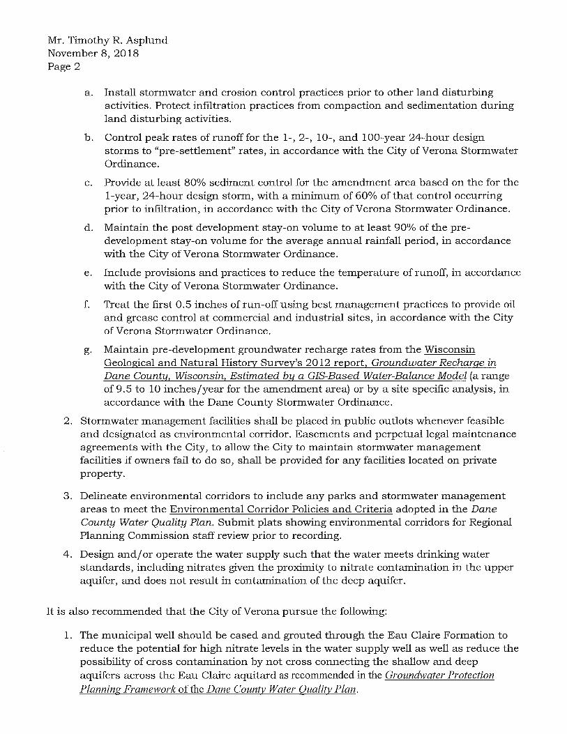
The city of Verona will demonstrate continued commitment to pursue the following: 1. Submit a detailed stormwater management plan for Regional Planning Commission staff review
and approval (in conjunction with DCL&WCD staff) prior to any land disturbing activities in theamendment area. The stormwater management plan shall include the following:
a. Install stormwater and erosion control practices prior to other land disturbing activities.Protect infiltration practices from compaction and sedimentation during land disturbingactivities.
b. Control peak rates of runoff for the 1-, 2-, 10-, and 100-year 24-hour design storms to"pre-settlement" rates, in accordance with the City of Verona Stormwater Ordinance.
c. Provide at least 80% sediment control for the amendment area based on the for the1- year, 24-hour design storm, with a minimum of 60% of that control occurring prior toinfiltration, in accordance with the City of Verona Stormwater Ordinance.
d. Maintain the post development stay-on volume to at least 90% of the predevelopmentstay-on volume for the average annual rainfall period, in accordance with the City ofVerona Stormwater Ordinance.
Scott Walker, Governor Daniel L. Meyer, Secretary
Telephone 608-266-2621 Toll Free 1-888-936-7463
TTY Access via relay - 711
State of Wisconsin DEPARTMENT OF NATURAL RESOURCES 101 S. Webster Street Box 7921 Madison WI 53707-7921
dnr.wi.gov wisconsin.gov

Page 2
e. Include provisions and practices to reduce the temperature of runoff, in accordance with the City of Verona Stormwater Ordinance.
f. Treat the first 0.5 inches of run-off using best management practices to provide oil and grease control at commercial and industrial sites, in accordance with the City of Verona Storm water Ordinance.
g. Maintain pre-development groundwater recharge rates from the Wisconsin Geological and Natural History Survey's 2012 report, Groundwater Recharge in Dane County, Wisconsin, Estimated by a GIS-Based Water-Balance Model (a range of 9.5 to 10 inches/year for the amendment area) or by a site specific analysis, in accordance with the Dane County Stormwater Ordinance.
2. Stormwater management facilities shall be placed in public outlots whenever feasible and designated as environmental corridor. Easements and perpetual legal maintenance agreements with the City, to allow the City to maintain stormwater management facilities if owners fail to do so, shall be provided for any facilities located on private property.
3. Delineate environmental corridors to include any parks and stormwater management areas to meet the Environmental Corridor Policies and Criteria adopted in the Dane County Water Quality Plan. Submit plats showing environmental corridors for Regional Planning Commission staff review prior to recording.
The Department also supports the recommendations that the City of Verona pursue the following:
1. The municipal well should be cased and grouted through the Eau Claire Formation to reduce the potential for high nitrate levels in the water supply well as well as reduce the possibility of cross contamination by not cross connecting the shallow and deep aquifers across the Eau Claire aquitard as recommended in the Groundwater Protection Planning Framework of the Dane County Water Quality Plan.
2. Continue to encourage the responsible use of deicers and water softeners as an active participant in the Wisconsin Salt Wise Partnership.
3. Collaborate with watershed-wide efforts to examine and address the concern of higher water levels in Badger Mill Creek.
4. Participate in the Green Tier Clear Waters Initiative, which aims to reduce the sediment and nutrient delivery to Dane County's lakes and streams from construction activities, beyond the current state and local requirements.
5. Work together with the Regional Planning Commission and other communities to address the issues of stormwater runoff volume control and flooding in the region. Consider formation of a drainage district or equivalent agreement to remove obstructions and maintain flow through Badger Mill Creek.
Statewide AWQM Plan Amendment This amendment is a formal update to the state’s Areawide Water Quality Management Plan and the Dane County Water Quality Plan and will be forwarded to the US Environmental Protection Agency to meet the requirements of the Clean Water Act of 1987 (Public Law 92-500 as amended by Public Law 95-217) and outlined in the federal regulations 40 CFR, Part 35. This review is an integrated analysis action under s. NR 150.20 (2) (a) 3, Wis. Adm. Code. By means of this review, the Department has complied with ch. NR 150, Wis. Adm. Code, and with s. 1.11, Wis. Stats. The approval of this sewer service area amendment does not constitute approval of any other local, state, or federal permit that may be required for sewer construction or associated land development activities. Appeal Rights:


• •
210 Mortin Luther King Jr. Blvd. Room 362 Madison, WI 53703 Phone: 608-266-4137 Fox: 608-266-9117 www.CopitolAreoRPC.org [email protected]
November 8, 2018
Mr. Timothy R. Asplund
Monitoring Section Chief WDNR- Bureau of Water Quality 101 S. Webster Street Madison, WI 53707-7921
Re: Water Quality Management Letter for Sewer Service Area Amendment Request# 1706 -Verona USA
Dear Mr. Asplund:
The City of Verona has submitted a sewer service area amendment application to the Capital Area Regional Planning Commission requesting an expansion of the Verona Urban Service Area. The proposed amendment is located in the Badger Mill Creek watershed. The proposed
amendment includes the addition of approximately 32.3 acres ofland to the Verona Urban
Service Area. There are no environmentally sensitive areas requiring placement in environmental corridors in accordance with the adopted environmental corridor policies and
criteria of the Dane County Water Quality Plan. A public hearing was held on the proposed amendment at the October 11, 2018 Regional Planning Commission meeting. The City's application and the Commission staffs analysis report of the proposed amendment have been
submitted to the Department's Surface Water Integrated Monitoring System.
It is the Capital Area Regional Planning Commission staffs opinion that the proposed amendment is consistent with water quality standards under Wis. Stat. § 281.15, with the conditions of approval identified below. Additional actions have also been recommended below to further improve water quality and environmental resource management.
At our November 8, 2018 meeting, the Capital Area Regional Planning Commission voted to recommend approval of this amendment to the Wisconsin Department of Natural Resources, based on the land uses and services proposed, and conditioned on the continued commitment of the City of Verona to pursue the following:
1. Submit a detailed stormwater management plan for Regional Planning Commissionstaff review and approval (in conjunction with DCL&WCD staff) prior to any land
disturbing activities in the amendment area. The stormwater management plan shall
include the following:


October 31, 2018
Staff Analysis of a Proposed Amendment to the Dane County Water Quality Plan Revising the Sewer Service Area Boundary in the Verona Urban Service Area
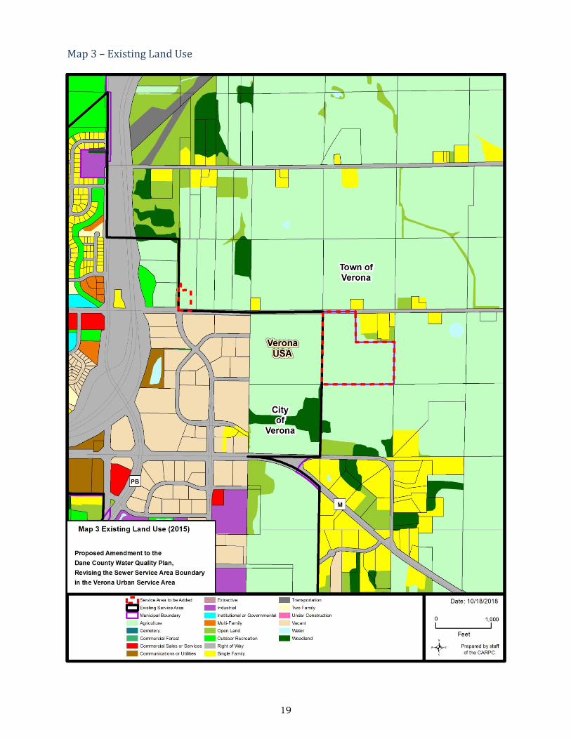
1) Existing Conditionsa) Land UseThe requested amendment areas are located on the southeast side of the City of Verona along its eastern border with the Town of Verona. Two acres of the requested amendment are currently still in the Town of Verona. Both amendment areas abut Whalen Road. (see Map 1). The amendment area within the Town is planned as a well site and the amendment area adjacent the planned Liberty Business Park (already within the City) is identified as “lower intensity non-residential land-uses such as offices or higher intensity residential land-uses such as high-density housing” in the City’s Southeast Neighborhood Plan. Both sites are contiguous to the Verona Urban Service Area.
Surrounding Land Uses Include: • North: Agriculture • South: Agriculture • West: Vacant Subdivided Land (business park), Agriculture • East: Agriculture and Rural Residential
b) Cultural and Historic Sites
The Wisconsin Historical Society (WHS) has been contacted regarding the presence of any known archaeological sites or cemeteries within the amendment area. No previously identified sites are recorded within the amendment area. WHS does not require a survey of the site because its location and the landforms present there suggest a low likelihood of pre-European settlement. In addition, portions of the area have been surveyed for the presence of cultural resources with negative results. However, in accordance with State of Wisconsin law, if human remains are unearthed during any phase of a project, all work must cease, and the local authorities must be contacted.
Existing Land Use Acres
Agriculture 31.7 Transportation 0.6 TOTAL 32.3
Proposed Land Use Proposed Env.
Corridor Acres Acres
Transportation 0.6 0 Utilities (well site) 1.6 0 Planned Development 30.1 0
TOTAL 32.3 0
2
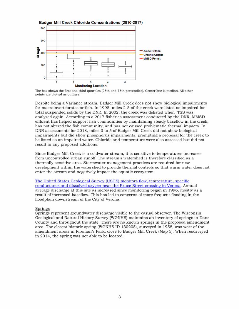
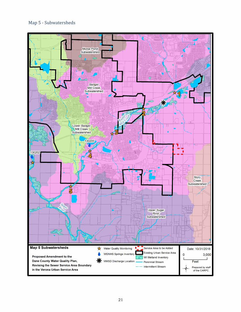
c) Natural Resources The proposed amendment areas are located in the southwestern portion of the Upper Badger Mill Creek subwatershed (Map 5), a tributary to the Upper Sugar River. The amendment areas drain to an unnamed intermittent tributary of Badger Mill Creek. There are no Environmentally Sensitive Areas such as wetlands, waterbodies, or floodplains in the amendment areas. Wastewater from the City of Verona is treated at the Madison Metropolitan Sewerage District Wastewater Treatment Facility. The treated effluent is discharged to Badfish Creek and Badger Mill Creek, bypassing the Yahara Chain of Lakes. Badger Mill Creek The main branch of Badger Mill Creek is designated as a Class II trout stream by the WDNR for fish management purposes, in accordance with NR 1.02(7). The creek flows 9.5 miles through the southwest side of City of Madison and bisects the City of Verona. Residential and agricultural land uses are the two most dominant land uses in the 29.6 square mile watershed, each occupying ¼ of the area. Ongoing development in Madison and Verona continues to change land use in the area. Upstream of MMSD effluent discharge point, Badger Mill Creek is intermittent as in flows through the City of Madison and generally only flows when there is significant runoff. Downstream of the MMSD discharge point, Badger Mill Creek flows 4.9 miles until it combines with the Upper Sugar River. Because of the MMSD discharge, Badger Mill Creek is classified as a Variance Stream for Uses and Designated Standards [NR 104.05(2)], which allows the WDNR to modify certain water quality standards for this stream to allow discharge of treated municipal wastewater. These stream Use Standards are state water quality standards established to guide water quality planning under NR 121. Since August 1998, MMSD has discharged about 3.3 mgd (5 cfs) of highly treated effluent to Badger Mill Creek as a way to maintain baseflow in the creek. This additional effluent compensates for groundwater extracted from the Sugar River basin by municipal wells. After groundwater is pumped and used, the wastewater is diverted to MMSD’s Nine Springs treatment plant and discharged to Badfish Creek, in the adjacent Rock River basin, and Badger Mill Creek, in the Sugar River Basin. This return of treated effluent helps to restore the water balance between these two basins and, more importantly, improves aquatic habitat in Badger Mill Creek by removing low baseflow as a limiting habitat condition. A variance in MMSD’s discharge permit allows the effluent to have a chloride concentration of 430 mg/l, higher than the state water quality chronic criteria of 395 mg/l, but lower than the acute criteria of 757 mg/l. This variance also requires MMSD to develop a source reduction program for controlling chlorides coming into the plant. In each permit term, additional reductions are expected until a weekly average below 395 mg/l can be maintained. Chloride in the effluent is primarily associated with water softening and deicers. MMSD monitors chloride concentrations at five locations along Badger Mill Creek (Map 5). This boxplot, showing data collected every other month since 2010, illustrates that the highest chloride concentrations are just downstream of the MMSD discharge (monitoring location 2). Concentrations at monitoring location 2 occasionally exceed the Wisconsin chronic criteria for chloride but decrease downstream to consistently meet the chronic criteria standard.
3
The box shows the first and third quartiles (25th and 75th percentiles). Center line is median. All other points are plotted as outliers. Despite being a Variance stream, Badger Mill Creek does not show biological impairments for macroinvertebrates or fish. In 1998, miles 2-5 of the creek were listed as impaired for total suspended solids by the DNR. In 2002, the creek was delisted when TSS was analyzed again. According to a 2017 fisheries assessment conducted by the DNR, MMSD effluent has helped support fish communities by maintaining steady baseflow in the creek, has not altered the fish community, and has not caused problematic thermal impacts. In DNR assessments for 2018, miles 0 to 5 of Badger Mill Creek did not show biological impairments but did show phosphorus impairments, prompting a proposal for the creek to be listed as an impaired water. Chloride and temperature were also assessed but did not result in any proposed additions. Since Badger Mill Creek is a coldwater stream, it is sensitive to temperatures increases from uncontrolled urban runoff. The stream’s watershed is therefore classified as a thermally sensitive area. Stormwater management practices are required for new development within the watershed to provide thermal controls so that warm water does not enter the stream and negatively impact the aquatic ecosystem. The United States Geological Survey (USGS) monitors flow, temperature, specific conductance and dissolved oxygen near the Bruce Street crossing in Verona. Annual average discharge at this site as increased since monitoring began in 1996, mostly as a result of increased baseflow. This has led to concerns of more frequent flooding in the floodplain downstream of the City of Verona. Springs Springs represent groundwater discharge visible to the casual observer. The Wisconsin Geological and Natural History Survey (WGNHS) maintains an inventory of springs in Dane County and throughout the state. There are no known springs in the proposed amendment area. The closest historic spring (WGNHS ID 130205), surveyed in 1958, was west of the amendment areas in Fireman’s Park, close to Badger Mill Creek (Map 5). When resurveyed in 2014, the spring was not able to be located.

4
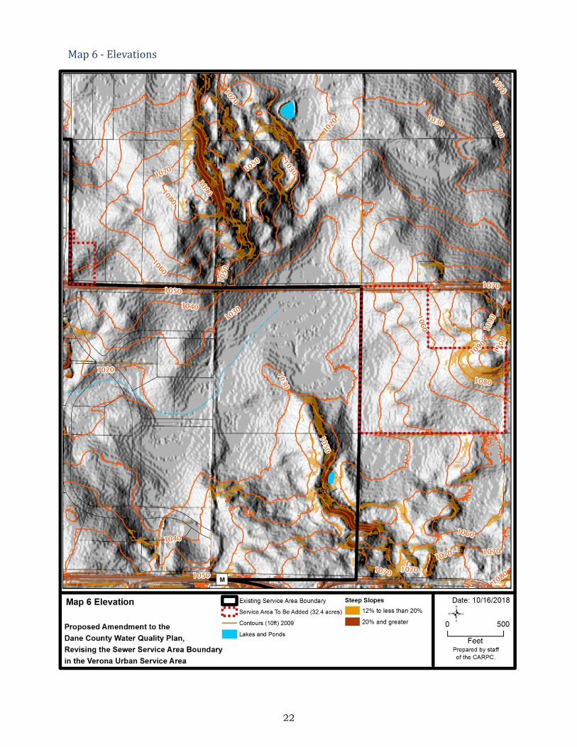
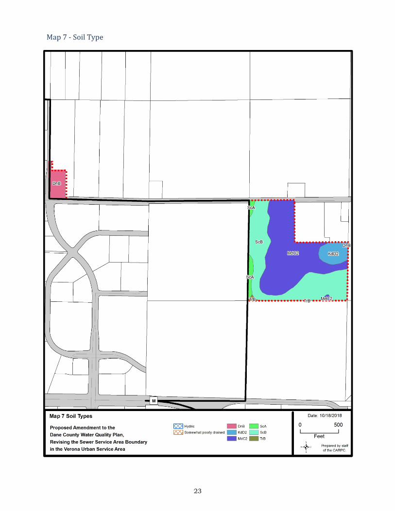
Groundwater Groundwater discharge generally occurs along the entire length of perennial streams and is the source of stream baseflow. The regional groundwater model has been used to evaluate the possible effects of current and future municipal groundwater well withdrawals on these stream systems. Groundwater modeling, using the 2016 Groundwater Flow Model for Dane County developed by the WGNHS, simulated regional changes in streamflow from pre-development to 2010 conditions. Because of the added discharge from the MMSD treatment plant, flows in Badger Mill Creek have increased compared to pre-development amounts. At the location where the unnamed tributary draining the amendment areas reaches Badger Mill Creek, the baseflow is more than 300% compared to pre-development (no pumping) conditions. In 2012, the WGNHS published a report, Groundwater Recharge in Dane County, Wisconsin, Estimated by a GIS-Based Water-Balance Model, estimating the existing groundwater recharge rates in Dane County based on the soil water balance method. The study estimates that the existing groundwater recharge rate in the amendment area ranges from 9.5 to 9.8 inches per year. Endangered Resources The DNR Bureau of Endangered Resources maintains a database representing the known occurrences of rare plants, animals, and natural communities that have been recorded in the Wisconsin Natural Heritage Inventory. A screening review of this database conducted by Regional Planning Commission staff for species designated as endangered, threatened, or of special concern did not identify any species of special concern within a one-mile radius of the amendment areas. Soils and Geology Both amendment area is located within the West Johnstown-Milton Moraines. The Land Type Associations of Wisconsin classifies the surficial geology of this area as rolling hummocky moraine and outwash plain complex with scattered bedrock knolls. Soils are predominantly well drained silt and loam over sandstone or dolomite calcareous sandy loam till, or calcareous gravelly sandy outwash. Surface elevations in the Well 6 amendment area range from 1040 feet to 1060 feet and from 1030 to 1110 in the Liberty Business Park amendment area. The Liberty Business Park amendment area includes limited areas of steep (> 12%) and very steep (>20%) slopes in the east-central portion of the amendment area (see Map 6). Current erosion control requirements provide for protection of steep slopes. There are no steep slopes adjacent to riparian areas, which would require designation as environmental corridors . According to the Natural Resource Conservation Service (NRCS) Soil Survey of Dane County, the soils in both the amendment areas are Dodge-St. Charles-McHenry association. Dodge-St. Charles-McHenry association soils are moderately well drained and well drained, deep silt loams. The Table 2 shows detailed classification for soils in the amendment area (see Map 7). Table 3 shows important soil characteristics for the amendment area (see Map 7). There are no hydric soils within the amendment area (see Map 7). Hydric soils are good indicators of existing and former (drained) wetlands. According to the Soil Survey Geographic data for Dane County developed by the USDA Natural Resources Conservation Service, St. Charles and Troxel soils (ScA, ScB, and TrB map units) are not hydric, but they can have a seasonal (April to June) zone of water saturation within 5 feet of the ground surface. These soils are classified as either well drained or moderately well drained. Soils with seasonal high water tables that are also classified as well drained or moderately well drained generally do not pose limitations for buildings with basements.

5
Table 2 Soils Classification
Soil % of Area General Characteristics
Dodge Silt Loam; DnB 6.3
Deep, well drained, gently sloping and sloping soils on glaciated uplands. Soils have high fertility, moderate permeability, and a moderate to severe hazard of erosion. Poses moderate limitations for development due slope and shrink/swell potential.
Kidder Loam; KdD2 6.8
Deep, well drained, gently sloping to very steep soils on glaciated uplands. Soils have medium fertility, moderate permeability, and a very severe hazard of erosion and are moderately droughty. Poses severe limitations for development due to steep slopes.
McHenry Silt Loam; MdC2 45.9
Deep, well drained, gently sloping to moderately steep soils on glaciated uplands. Soils have medium fertility, moderate permeability, and a moderate to severe hazard of erosion. Poses slight to moderate limitations for development due to slopes, shrink/swell potential and low bearing capacity.
St. Charles Silt Loam; ScA 3.0
Deep, nearly level to moderately steep, well drained and moderately well drained soils on glaciated uplands. Soils have high fertility, moderate permeability, and a limited hazard of erosion. Poses slight to moderate limitations for development due to shrink/swell potential and low bearing capacity.
St. Charles Silt Loam; ScB 37.5
Deep, well drained, sloping soils to moderately steep soils on glaciated uplands. Soils have high fertility, moderate permeability, and a moderate to severe hazard of erosion. Poses moderate limitations for development due to slopes, shrink/swell potential and low bearing capacity.
Troxel Silt Loam; TrB 0.4
Deep, well drained and moderately well drained, gently sloping soils in draws, on fans, and in drainageways. Soils have high fertility, moderate permeability, and a moderate hazard of erosion. Poses moderate limitations for development due to shrink/swell potential and depth to saturated zone.
Source: Soil Survey Geographic data for Dane County developed by the USDA Natural Resources Conservation Service
Table 3 Soils Characteristics
Characteristic Soil Map Symbols (see Map 7) % of Area
Prime Agricultural Soils DnB, ScB 44.2
Hydric Soils (Indicates Potential / Restorable Wetlands) None 0
Soils with Seasonal High Water Table (< 5’) ScA, ScB, TrB 40.9
Soils Associated with Steep Slopes (> 12%) KdD2 6.8
Soils Associated with Shallow Bedrock (< 5’) None 0
Poorly Drained Soils None 0
Best Potential for High Rates of Infiltration in Subsoils KdD2, MdC2, ScB, TrB 90.6
Source: Soil Survey Geographic data for Dane County developed by the USDA Natural Resources Conservation Service

6
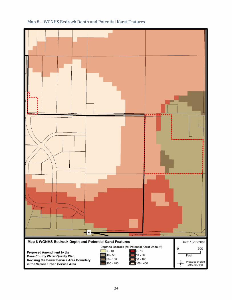
According to WGNHS data, bedrock within the Liberty Business Park amendment area is split between the Ancell Group on the east portion of the site and Prairie du Chien Group on the west portion of the site. The Well #6 amendment bedrock is also part of the Prairie du Chien Group. Bedrock within the Prairie du Chien Group is dolomite, minor sandstone, cherty dolomite; vuggy, sandy, and oolitic, consists of two formations, the Shakopee and the Oneota. Thickness is from 145 feet in eastern Dane County to 220 feet in western Dane County. Bedrock within the Ancell Group is quartz sandstone, dolomitic siltstone, silty dolomite, and sandy dolomite. It consists of two formations, the Jordan and the underlying St. Lawrence, which were combined as one mapping unit. The thickness is about 75 feet where not eroded. According to WGNHS data, the depth to bedrock ranges from 15 feet in the northeast part of the Liberty Business Park amendment area to greater than 60 feet in the southwest. Depth to bedrock in the Well #6 amendment area is ranges from 175 to 225 feet, (see Map 8). As is common throughout much of the upper Midwest, karst features such as enlarged bedrock fractures are prevalent in the local dolomite uplands. Karst features such as vertical fractures and conduits provide primary pathways for groundwater movement and can dramatically increase groundwater susceptibility when present. The location of karst features are difficult to predict, and the thickness and type of the overlying soil greatly affects how much water drains into them. Where clay soils are thick, infiltration rates are likely to be very low. However, where bedrock fractures are near the surface infiltration rates can be very high. Based on the WGNHS karst potential data, karst features may be encountered in the both the Liberty Business Park and Well #6 amendment areas (see Map 8). The depths to potential karst units in the Well #6 amendment area range from 175 to 225 feet. Potential karst features within the Liberty Business Park amendment area exist on the west portion of the amendment area with depths to karst ranging from 45 to 60 feet. Potential karst features in the amendment area are located at a depth where they are not a concern. According to the NRCS soils map data, the amendment area has the potential for a seasonal high water table within five feet of the surface. There is no minimum separation distance for roofs draining to surface infiltration practices. However, the Dane County ordinance requires infiltration practices to be located so that the separation distance between the bottom of the infiltration system and the elevation of seasonal high groundwater or the top of bedrock is at least 5 feet for residential arterial roads and 3 feet for other impervious surfaces.
2) Proposed Urban Services a) Parks and Open Space There is currently no concept development plan for the Liberty Business Park amendment area. The size and location of any parks, open space, and stormwater management areas will be determined as specific development plans are prepared and approved. Any stormwater management areas or parks and open space will be designated as environmental corridors, as appropriate. b) Public Water System The Verona Water Utility operates five high capacity wells with a combined capacity to deliver 8,740,000 gallons per day (gpd), or 6,069 gallons per minute (gpm) (see Map 10). Well #1, yielding 369 gpm, is 771 feet deep. Well #2, yielding 1,000 gpm, is 1,153 feet deep. Well #3, yielding 1,000 gpm, is 1,033 feet deep. Well #4, yielding 1,500 gpm, is 1,100 feet deep. Well #5, yielding 2,200 gpm, is 1,493 feet deep. The current firm pumping capacity (with the largest well out of service) is 3,869 gpm and the current reported average peak hourly water demand is 1,200,000 gpd, or 833 gpm.

7
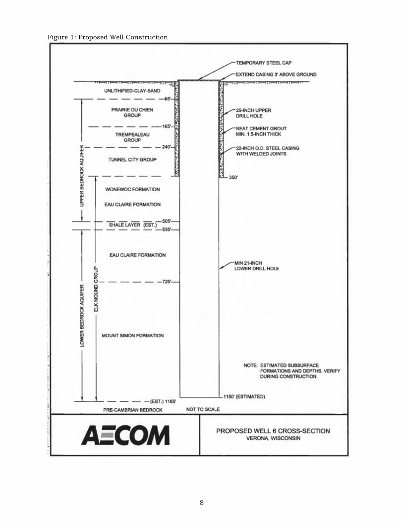
It is planned that Well #1, which was built in 1932 and is located close to the central commercial area, will be abandoned in the future as it has a relatively shallow casing of 114 feet and has seen increases in chloride and nitrate-nitrogen concentrations. A planned future Well #6, is proposed to be located within the amendment area. Bid plans and specifications have been prepared for the proposed well and approvals have been granted by the Public Service Commission and Department of Natural Resources. A 2017 report completed by the AECOM, titled Well Site Investigation Report – Proposed Well 6 City of Verona, WI, states that the anticipated pumping capacity will be up to 2,000 gpm. It is proposed to have a 350 foot grouted casing, through the Trempealeau Group and Tunnel City Group strata. The remaining 700 feet of borehole depth is proposed to be open to both the Upper and Lower Bedrock Aquifers for a total well depth of 1,150 feet (Figure 1). The report concludes that adjacent private wells completed in the upper bedrock aquifer should not be significantly impacted by pumping from the lower bedrock aquifer at the proposed Well #6 site. A 2015 report on nitrates in Dane County indicates that the area to the east of the well site is a nitrate hotspot, with estimated nitrate levels in the upper aquifer in excess of 14 mg/l (Map 11). The drinking water standard for nitrates is 10 mg/l. The Groundwater Protection Planning Framework of the Dane County Water Quality Plan recommends that municipal wells should design with adequate casing depth to be sure to avoid cross-connecting the shallow and deep aquifers across the Eau Claire aquitard. Casing the well down to the deep aquifer will also reduce the potential for high nitrate levels in the water supply well. The Verona Water Utility currently operates four reservoirs for water storage: #1 Central Zone Elevated Tank (300,000 gallons), #2 North High Pressure Elevated Tank (500,000 gallons), #3 Well 5 Ground Reservoir (500,000 gallons) with a 2,000 gpm supply booster station, and Southeast High Pressure Elevated Tanks (300,000 gallons) with a 1,000 gpm booster station, totaling a maximum storage capacity of 1,600,000 gallons. The current average daily water demand is approximately 1,200,000 gallons. Therefore, the system has more than adequate storage capacity to meet the current average daily demand. The 2015 Water System Master Plan report, by AECOM, projects the 2040 average daily demand to be 3.33 mgd with a peak hour demand of 8,000 gpm with a projected population increase of from 11,500 people in 2015 to 22,000 in 2040, representing a 2.5 percent increase year-over-year. The Master Plan includes the proposed amendment areas within the evaluation area (Map 9). The report also recommends improvements to a 12-inch water main in Liberty Drive, just west of the amendment areas, as well as the addition of a future 12-inch mains looping around both amendment areas. The amendment areas are within the Southeast Zone and will be served by an extension from the existing 8-inch watermain on Clarity Street. This watermain will then be looped back into the existing 12-inch main on Liberty Drive within the Ambition Street right-of-way. Proposed land use from the Master Plan is consistent with the proposed land use for the amendment areas. Therefore, the additional demand associated with the amendment areas will be accommodated based on the current pumping capacity and future projected demands. Water losses in the City’s distribution system peaked at a level of 24% of net water supplied in 2014 resulting from several breakages during the year. The City responded by committing to quarterly water loss monitoring by the Water Utility. Subsequent losses were 3% in 2015, 2% in 2016, and 8% in 2017. The Wisconsin Administrative Code PSC 185.85(4)(b) requires a utility with more than 1,000 customer to submit a water loss control plan to the Public Service Commission if the utility reports its percentage of water losses exceed 15%.
8
Figure 1: Proposed Well Construction
9
c) Wastewater Sanitary sewer service will be provided to the amendment area by a 10-inch future main extensions connecting to the existing 12-inch East Side Interceptor (Map 9). This proposed sanitary network drains into progressively larger mains prior to entering into the MMSD Pump Station Number 17. Current average daily flow from the City of Verona to the MMSD wastewater treatment plan was 0.94 mgd in 2016. The 2007 City of Verona Wastewater Master Plan report, by Earth Tech, Inc., assumed future development densities of 9 to 11 single family units per acre, 12 to 18 duplex units per acre and 14 to 22 multi-family units per acre. Recent City multi-family densities have been higher at 36 units per acre. Wastewater generation per capita has averaged 81 gpd, and accounting for infiltration and inflow has been 90 gpd. The City estimates that the peak daily wastewater generation is four times the average daily flow, or 360 gallons per capita per day. Commercial and industrial development has an average generation of 600 gallons per acre per day. Based on these values and assuming 5 acres is dedicated to right-of-way and stormwater management, the Liberty Business Park amendment area could produce as little as 16,800 gpd (12 gpm) if developed entirely as commercial or as high as 90,720 gpd (63 gpm) if development is entirely multi-family. Using a peaking factor of 4.0, this would result in a peak discharge of 67,200 to 362,880 gpd, or 47 to 252 gpm, with the likely peak generation being somewhere in between. The estimate is consistent with historical wastewater generation rates in the City. The 2007 City of Verona Wastewater Master Plan report indicates that the existing sanitary sewer collection system that will receive flow from the amendment areas are at 25 to 75 percent full for a 10-year, 6-hour model event. At the time of publishing, the system had capacity for an additional 225,000 gpd without impact to the system. Therefore, even if the Liberty Business amendment area is developed entirely as multi-family homes, the existing system has capacity to accommodate the additional flows. MMSD Pumping Station 17 will ultimately serve this area. The projected average daily and peak flows are below the capacity of the interceptors. MMSD has a regular capital improvement planning process to periodically evaluate their system capacity and expanded the capacity of the system as the need is foreseen. Wastewater Treatment Facility MMSD will provide wastewater treatment for the amendment area. The Nine Springs Treatment Facility has a design capacity of 50 million gallons per day (mgd) and received an average of 40.7 mgd in 2016, including infiltration and inflow. It is expected to reach 90 percent of current hydraulic design capacity around 2026 based on current projected growth rate assumptions. MMSD has completed a long-range plan that evaluated various options for expanded treatment capacity to serve its current and future service area. For the 20-year planning period, service to this area is expected to remain at the existing wastewater treatment facility location with expanded capacity of the system as the need is foreseen.
Wastewater treatment at the district’s Nine Springs Treatment Facility does not remove chloride and the concentration of chloride that arrives at the Nine Springs Plant can exceed the water quality standard. In 2015, AECOM completed a study for MMSD which determined that while possible, treatment would be cost-prohibitive, energy intensive, and involve other environmental impacts1. MMSD’s Wisconsin Pollutant Discharge Elimination System (WPDES) permit which requires pollution prevention and source reduction initiatives for chlorides, such as the Wisconsin Salt Wise Partnership. MMSD has not had any issues meeting its WPDES permit limits for the quality of effluent discharged to Badger Mill Creek according to their 2016 Annual Report. In 2016, the effluent monthly average Total Suspended Solids ranged from 3.4 to 7.5 mg/L, below the 10 to 16 mg/L permit limit for Badger Mill Creek. The effluent monthly average ammonia ranged from 0.07 to 0.43
1 Chloride Compliance Study Nine Springs Wastewater Treatment Plant Final Report, AECOM, 2015

10
mg/L, below the 1.1 to 3.8 mg/L permit limit for Badger Mill Creek. The effluent monthly average total phosphorus ranged from 0.26 to 0.46 mg/L, below the current 1.5 mg/L permit limit but not low enough to meet future water quality based effluent limits (WQBEL) for phosphorus. The total phosphorus monthly limit of 1.5 mg/L is an interim limit and will be reduced to 0.075 mg/L on a six month average and 0.225 mg/L on a monthly average. MMSD has implemented a Watershed Adaptive Management approach, leading a diverse group of partners called Yahara Watershed Improvement Network (Yahara WINs) in implementing phosphorus reducing practices in the watershed. d) Stormwater Management System The amendment area for Liberty Business Park drains to the property to the west, which is another part of the Liberty Business Park. From there, it drains into an unnamed intermittent stream, which ultimately drains to Badger Mill Creek. The stormwater management concept for the Liberty Business Park amendment area is to utilize either individual/private basins or regional public facilities to manage stormwater as parcels develop.. These facilities will be designed to adequately provide water quality treatment (80% TSS reduction) followed by volume reduction facilities, which will provide for annual stay-on (90% stay-on of the average annual storm). It is anticipated that infiltration performance will further reduce TSS (and other pollutants such as Total Phosphorus) from stormwater discharges. Collectively, the stormwater facilities will provide peak discharge rate control to account for storms up to and including the 100-year rainfall event. A majority of the topographic low points along the west side of the Liberty Business Park amendment area have St. Charles silt loam. This soil type is classified as having the potential to experience an apparent seasonal high water table between three and five feet of the surface between February and June, due to a high clay content in the upper 4 to 5 feet of the soils profile, which can cause a perched water table. This soil type is also classified as having a high rate of infiltration in the subsoils (at a depth greater than 5 feet) due to high sand content. The standard practice in constructing stormwater infiltration facilities is to excavate down to the high infiltration sand layer and backfill with sand. The DNR Conservation Practice Standard 1002 - Site Evaluation for Stormwater Infiltration requires field testing with test pits to verify the suitability of areas planned for stormwater infiltration practices. This includes a site assessment for karst features on the site to locate infiltration facilities appropriately so that performance can be maximized while protecting groundwater resources. In sites where limiting conditions are found that would exempt or prohibit infiltration in the low areas, the stormwater management plan should incorporate volume reduction strategies (i.e. bioretention, porous pavement, green roofs, etc.) higher in the landscape. Performance Standards The City of Verona proposes stormwater management performance measures to meet or exceed standards required by the State of Wisconsin (NR 151), Dane County (Chapter 14), and City of Verona (Chapter 15-2) stormwater regulations, as follows: 1) Require post-construction sediment control (reduce total suspended solids leaving the
site by at least 80%, with a minimum of 60% of that control occurring in a retention pond prior to infiltration) for the 1-year, 24-hour design storm. This is consistent with the standards currently required by Dane County.
2) Require post-construction peak runoff rate control for the 1-, 2-, 10-, and 100-year, 24-
hour design storms to “pre-settlement” peak runoff rates. This is consistent with the range of design storms currently required by Dane County but exceeds the Dane County requirement of matching the “pre-developed” peak runoff rate.
3) Require post-development stay-on volume of at least 90% of pre-development stay-on
volume. This is consistent with the stay-on standard for new development currently required by Dane County regulations.

11
4) Include provisions and practices to reduce the temperature of runoff. This is consistent
with the standards currently required by Dane County. 5) Treat the first 0.5 inches of run-off using best management practices to provide oil and
grease control at commercial and industrial sites. This is consistent with the standards currently required by Dane County.
6) Maintain pre-development groundwater annual recharge rate of 9.5 to 9.8 inches per
year for this area as estimated by the Wisconsin Geological and Natural History Survey in a 2012 report titled “Groundwater Recharge in Dane County, Wisconsin Estimated by a GIS-Based Water Balance Model.” This is consistent with the standards currently required by Dane County.
e) Environmental Corridors Within this amendment area, there are no Environmentally Sensitive Areas (i.e. wetlands, waterbodies, floodplains, riparian steep (> 12%) slopes, etc.) requiring placement in environmental corridors according to the adopted policies and criteria of the Dane County Water Quality Plan. Any stormwater ponds management areas and or parks and open space will be designated as environmental corridors, as appropriate.
3) Impacts and Effects of Proposal a) Meeting Projected Demand Current projections suggest that an additional 6,233 residents and 2,919 housing units can be expected in the Verona Urban Service Area between 2010 and 2040. Land demand projections in 2014 estimated that a total of 721 additional residential acres and 1,094 employment-based acres would be needed by 2040 to accommodate growth. Department of Administration (DOA) population estimates for 2018 indicate that 12,384 people call Verona home, an increase of 1,765 people since 2010.2 This population increase is roughly in line with DOA projections. b) Phasing There are no current plans for specific phasing of development in the amendment areas. c) Surface Water Impacts
Development creates impervious surfaces (i.e., streets, parking areas, and roofs) and typically alters the natural drainage system (e.g., natural swales are replaced by storm sewers). Without structural best management practices (i.e., detention basins and infiltration basins) this would result in increased stormwater runoff rates and volumes, as well as reduced infiltration. Without structural best management practices for erosion control, development would also cause substantial short-term soil erosion and off-site siltation from construction activities. Scientific research has well documented that without effective mitigation measures, the potential impacts of development on receiving water bodies can include the following:
• Flashier stream flows (i.e., sudden higher peaks) • Increased frequency and duration of bankfull flows • Reduced groundwater recharge and stream base flow • Greater fluctuations in water levels in wetlands
2 DOA estimates are given for each municipality, which do not necessarily coincide with Urban Service Area boundaries.

12
• Increased frequency, level (i.e., elevation), and duration of flooding • Additional nutrients and urban contaminants entering the receiving water bodies • Geomorphic changes in receiving streams and wetlands
Natural drainage systems attempt to adapt to the dominant flow conditions. In the absence of mitigation measures, the frequency of bank-full events often increases with urbanization, and the stream attempts to enlarge its cross section to reach a new equilibrium with the increased channel forming flows. Higher flow velocities and volumes increase the erosive force in a channel, which alters streambed and bank stability. This can result in channel incision, bank undercutting, increased bank erosion, and increased sediment transport. The results are often wider, straighter, sediment laden streams, greater water level fluctuations, loss of riparian cover, and degradation of shoreland and aquatic habitat. Since 2004, there have been stormwater management standards in effect at the state, county, and local level to require stormwater management and erosion control plans and structural best management practices to address the impacts of development on water quality, runoff volumes, peak flows, water temperature, and groundwater recharge. The City proposes to mitigate the urban nonpoint source impacts of the proposed development by requiring the implementation of various stormwater best management practices that are designed and constructed to meet or exceed current standards for pollutant reduction, runoff volumes, peak flows, water temperature, and groundwater recharge. This will address the potential water quality impacts of stormwater runoff from the proposed development on the receiving waters. The current standard for runoff volume control/infiltration in Dane County is 90% of pre-development levels. While this is a significant improvement compared to before 2004 (when there was no requirement), it still results in an increase in average annual runoff from 1.8 inches per year to 4.5 inches per year for typical conditions. Cumulatively this contributes to water quantity impacts such as regional flooding. The City of Verona is also actively working to address chlorides by implementing many of the program and procedures recommended by the Wisconsin Salt Wise Partnership. Road crew supervisors attend Salt Wise trainings annually and salt brine is used for pre-wetting and anti-icing techniques to reduce salt use and loss. The City had their salt trucks calibrated to optimize salt spread and reduce usage. New development is not expected to exacerbate effluent chloride concentrations since the new high efficiency water softeners currently required by Wisconsin’s plumbing code are substantially more efficient3 than the old timer based softeners still found in many homes. d) Groundwater Impacts Without effective mitigation practices, as natural areas are converted to urban development, the ground/surface water balance in streams and wetlands shifts from a groundwater-dominated system to one dominated more and more by surface water runoff. This leads to subsequent reductions in stream quality and transitions to more tolerant biological communities. The 2016 Groundwater Flow Model for Dane County, developed by the WGNHS, was used to examine simulated regional changes in streamflow. The two amendment areas drain to an intermittent stream that flows to Badger Mill Creek. Pre-development (no pumping) baseflow conditions downstream of the confluence with that intermittent stream were modeled to have a discharge of 1.09 cfs (Map 12 and Table 4). Current modeled conditions, without Verona’s proposed Well #6, were 3.46 cfs. This increase from pre-development to current conditions is attributed to the upstream MMSD effluent discharge. With the
3 The Reduction of Influent Chloride to Wastewater Treatment Plants by the Optimization of Residential Water Softeners, Madison Metropolitan Sewerage District.

13
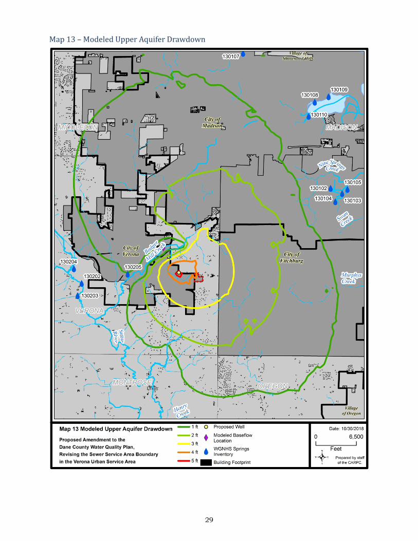
proposed Well #6, stream discharge was modeled to decrease to 2.94 cfs, a flow reduction of 0.52 cfs (15%). Where the 50 and 100 year zone of contribution approach Badger Mill Creek, close to where baseflow was modeled, drawdown in the upper aquifer is modeled to be less than 1 foot (Map 13). This well location establishes an effective recycling of the water resource where the MMSD effluent returns the used groundwater to the surface water system after it has been treated. According to the 2014 DNR report Ecological Limits of Hydrologic Alteration in Dane County Streams, Badger Mill Creek has a fish community that would be sensitive to reductions in baseflow, with American brook lamprey, brown trout, and mottled sculpin being the most sensitive to flow change. Therefore continuation of the MMSD effluent return, or some other method of maintaining baseflow, is important in this watershed. Current withdrawal modeled conditions were compared to modeled conditions with the addition of Well #6. The drawdown of the upper aquifer associated with the proposed well reaches a maximum 5 feet cone of depression over approximately 12 acres surrounding the well (Map 13). There are no private wells located within this area. An aquifer drawdown of 4 feet was modeled to occur over approximately ½ a square mile. The nearest residential property in the Town of Verona is approximately 1,300 feet east of the proposed well. Based on available construction reports for private wells in the general area, private wells are typically drilled 200 to 270 feet deep, and have a static water level at a depth ranging from 85 to 165 feet. These wells typically operate with 30 to 40 feet of head (the height of the static water level at the time of well construction above the location of the pump in the well) and are open to 65 to 110 feet of the upper aquifer. Thus a 4 foot decrease in the level of the upper aquifer is not significant impact for these wells. Groundwater levels naturally vary within about a 15 foot range, depending on precipitation. The loss of baseflow from the cumulative effects of well water pumping is a regional issue, beyond the boundaries of a single Urban Service Area Amendment or even a single municipality. This issue is discussed along with potential management options in the recently updated Dane County Groundwater Protection Planning Framework (Technical Appendix G of the Water Quality Plan). The return of treated effluent to the system, as is being done for Badger Mill Creek, is one of the most effective ways to address baseflow loss from water well pumping. Maintaining pre-development groundwater recharge also helps to maintain baseflow and mitigate this impact. CARPC staff recommends maintaining the pre-development annual recharge rate of 9.5 to 9.8 inches per year for this area as estimated by the Wisconsin Geological and Natural History Survey. Experience has shown that this criterion is generally met when the volume control standard is achieved by infiltration practices.
Table 4 Modeled Baseflow Results
Due to Current and Anticipated Future Municipal Well Water Withdrawals (All Municipal Wells)
Stream No Pumping 2010 With Well #6
Badger Mill Creek 1.09 cfs 3.46 cfs 2.94 cfs
As noted in the Groundwater Protection Planning Framework of the Dane County Water Quality Plan, high-capacity wells should design the wells (e.g., adequate casing depth, etc.) to be sure to avoid cross-connecting the shallow and deep aquifers across the Eau Claire aquitard. High-capacity wells with shallow casings create a vertical conduit that can allow groundwater contaminants, such as nitrates, to move rapidly between the shallow and deep bedrock aquifers.
14
4) Comments Received and Unresolved Issues A public hearing was held on the proposed amendment at the October 11, 2018 meeting of the Capital Area Regional Planning Commission. No members of the public submitted comments or spoke at the public hearing. Key comments and questions from Commissioners at the public hearing were related to depth of the new well, the resulting cone of depression, and the history of nitrate contamination in that area. Actions have been recommended to the City to further improve water quality and environmental resource management in response to the issues raised. Additional comments were related to land use and transportation issues and will be evaluated in the staff analysis and/or management letter for the Land Use and Transportation Plan.
5) Conclusions and Staff Water Quality Recommendations There is sufficient existing treatment plant system capacity at MMSD to serve the proposed amendment area. There is also sufficient existing wastewater collection system capacity to serve the proposed amendment area. Since 2004, there have been stormwater management standards in effect at the state, county, and local level to require stormwater management and erosion control plans and structural best management practices to address the impacts of development on water quality, runoff volumes, peak flows, water temperature, and groundwater recharge. The City proposes to mitigate the urban nonpoint source impacts of the proposed development by requiring the implementation of stormwater best management practices that are designed and constructed to meet or exceed current standards for pollutant reduction, runoff volumes, peak flows, water temperature, and groundwater recharge. This will address the potential water quality impacts of the proposed development on the receiving waters. High-capacity wells with shallow casings create a vertical conduit that can allow groundwater contaminants to move rapidly between the shallow and deep bedrock aquifers. This is particularly a concern in areas known to have significant nitrate contamination in the upper aquifer, as is the case here. The Groundwater Protection Planning Framework of the Dane County Water Quality Plan, recommends that high-capacity wells should be designed (e.g., adequate casing depth, etc.) to be sure to avoid cross-connecting the shallow and deep aquifers across the Eau Claire aquitard. It is recommended that the City of Verona construct their municipal well to be cased and grouted through the Eau Claire Formation to reduce the potential for high nitrate levels in the water supply well as well as reduce the possibility of cross contamination by not cross connecting the shallow and deep aquifers across the Eau Claire aquitard. Many municipalities in the region are participating to varying degrees in the Wisconsin Salt Wise Partnership, a regional effort to reduce chlorides in our water resources by encouraging the responsible use of deicers and water softeners. The City of Verona has been actively working to address chlorides by implementing many of the program and procedures recommended by Wisconsin Salt Wise. It is recommended that the City of Verona continue to encourage the responsible use of deicers and water softeners as an active participant in the Wisconsin Salt Wise Partnership. Another regional water quality effort is the Green Tier Clear Waters Initiative, which aims to reduce the sediment and nutrient delivery to Dane County's lakes and streams from construction activities, beyond the current state and local requirements. Green Tier is a Wisconsin Department of Natural Resources program that rewards businesses who demonstrate superior environmental performance with streamlined permitting and other benefits. Their mission is also to develop alternative approaches and practices that will result in better erosion control and improved long-term stormwater management. Site inspections have demonstrated that Green Tier program participants have superior erosion control performance compared to non-participants. The charter (contract) is a partnership effort between the participating units of government (currently Dane County, the City of
15
Madison, the City of Sun Prairie, and the Department of Natural Resources) and the participating home building and construction companies (currently Veridian Homes LLC and Homburg Contractors). It is recommended that the City of Verona also consider participating in this program. The current standard for runoff volume control/infiltration in Dane County is 90% of pre-development levels. While this is a significant improvement compared to before 2004 (when there was no requirement), it still results in an increase in average annual runoff from 1.8 inches per year to 4.5 inches per year for typical conditions. Cumulatively this “legacy runoff volume” combined with the continued incremental increase in runoff volume from new development contributes to an increased risk of regional flooding. It is recommended that the City of Verona work together with the Regional Planning Commission and other communities to address the issues of stormwater runoff volume control and flooding in the region. It is the Regional Planning Commission staff’s opinion that the proposed amendment is consistent with water quality standards under Wis. Stat. § 281.15, with the conditions of approval identified below. Additional actions have also been recommended below to further improve water quality and environmental resource management. a) Conditions Regional Planning Commission staff recommends approval of this amendment, based on the land uses and services proposed, and conditioned on the continued commitment of the City of Verona to pursue the following:
1. Submit a detailed stormwater management plan for Regional Planning Commission staff review and approval (in conjunction with DCL&WCD staff) prior to any land disturbing activities in the amendment area. The stormwater management plan shall include the following:
a. Install stormwater and erosion control practices prior to other land disturbing
activities. Protect infiltration practices from compaction and sedimentation during land disturbing activities.
b. Control peak rates of runoff for the 1-, 2-, 10-, and 100-year 24-hour design storms to “pre-settlement” levels, in accordance with the City of Verona Stormwater Ordinance.
c. Provide at least 80% sediment control for the amendment area based on the average annual rainfall, with a minimum of 60% of that control occurring prior to infiltration, in accordance with the City of Verona Stormwater Ordinance.
d. Maintain the post development stay-on volume to at least 90% of the pre-development stay-on volume for the average annual rainfall period, in accordance with the City of Verona Stormwater Ordinance.
e. Include provisions and practices to reduce the temperature of runoff, in accordance with the City of Verona Stormwater Ordinance.
f. Treat the first 0.5 inches of run-off using best management practices to provide oil and grease control at commercial and industrial sites, in accordance with the City of Verona Stormwater Ordinance.
g. Maintain pre-development groundwater recharge rates from the Wisconsin Geological and Natural History Survey’s 2012 report, Groundwater Recharge in Dane County, Wisconsin, Estimated by a GIS-Based Water-Balance Model (a range of 9.5 to 9.8 inches/year for the amendment area) or by a site specific analysis, in accordance with the Dane County Stormwater Ordinance.

16
2. Stormwater management facilities shall be placed in public outlots whenever feasibleand designated as environmental corridor. Easements and perpetual legal maintenanceagreements with the City, to allow the City to maintain stormwater managementfacilities if owners fail to do so, shall be provided for any facilities located on privateproperty.
3. Delineate environmental corridors to include any parks and stormwater managementareas to meet the Environmental Corridor Policies and Criteria adopted in the DaneCounty Water Quality Plan. Submit plats showing environmental corridors for RegionalPlanning Commission staff review prior to recording.
b) Recommendations
It is also recommended that the City of Verona pursue the following:
1. The municipal well should be cased and grouted through the Eau Claire Formation toreduce the potential for high nitrate levels in the water supply well as well as reduce thepossibility of cross contamination by not cross connecting the shallow and deepaquifers across the Eau Claire aquitard, as recommended in the Groundwater ProtectionPlanning Framework of the Dane County Water Quality Plan.
2. Continue to encourage the responsible use of deicers and water softeners as an activeparticipant in the Wisconsin Salt Wise Partnership.
3. Collaborate with watershed-wide efforts to examine and address the concern of higherwater levels in Badger Mill Creek.
4. Participate in the Green Tier Clear Waters Initiative, which aims to reduce the sedimentand nutrient delivery to Dane County's lakes and streams from construction activities,beyond the current state and local requirements.
5. Work together with the Regional Planning Commission and other communities toaddress the issues of stormwater runoff volume control and flooding in the region.

17
6) Maps Map 1 - Amendment Area

18
Map 2 – Aerial
19
Map 3 – Existing Land Use

20
Map 4 – Planned Land Use
21
Map 5 - Subwatersheds
22
Map 6 - Elevations
23
Map 7 - Soil Type
24
Map 8 – WGNHS Bedrock Depth and Potential Karst Features

25
Map 9 – Planned Sanitary Sewer and Water Service

26
Map 10 – Municipal Wells

27
Map 11 – Nitrates in the Upper Aquifer

28
Map 12 – Zones of Contribution for Proposed Well 6
29
Map 13 – Modeled Upper Aquifer Drawdown

1
Amendment Area: The City of Verona is requesting an Urban Service Area (USA) amendment to add approximately 33.5-acres to the City of Verona USA. Lands included within this amendment include lands located within the City’s Southeast Neighborhood.
Plan Consistency and Need: The Liberty Business Park parcel is located within the City’s Southeast Neighborhood Plan and is identified as a future “transition” use from non-residential uses to the west, and residential uses to the east. The Well #6 Site is identified as a future non-residential land use. Transitional uses identified in the Plan include “lower intensity non-residential land-uses such as offices or higher intensity residential land-uses such as high-density housing.”1 The Liberty Business Park property is currently zoned Rural Agriculture (RA), which is considered a holding zone for future development. A future rezoning is necessary and will be consistent with the Neighborhood Plan.
The City adopted a Water System Master Plan September of 2006. Both parcels are located within the Southeast Pressure Zone. The Liberty Business Park parcel was located outside the city limits at the time of the creation of the Water System Master Plan, but was included in the future city limits.2 The proposed USA Amendment is consistent with the City’s Comprehensive Plan.
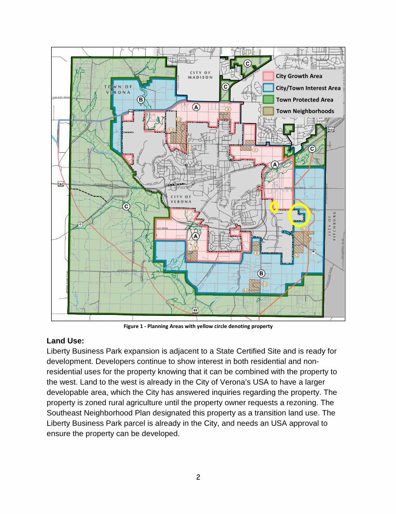
Intergovernmental Cooperation: The City and Town of Verona adopted an Intergovernmental Agreement3 allowing both governments to cooperate on issues, including municipal boundaries, and both the City and Town have benefited from the creation of this agreement. The proposed amendments are located in both the City and Town of Verona. The Agreement states “the City and Town agree to limit rural development that would make it difficult to efficiently extend urban services to that area in the future”4. The Town is aware of the City of Verona USA amendment and has not provided any objections to the application. All of the land being requested is located within areas planned by the City in the Comprehensive Plan and neighborhood plans as depicted in Figure 1.
1 Transition-Area Land Uses, Southeast Neighborhood Plan, p. 16, http://www.ci.verona.wi.us/DocumentCenter/View/626/Adopted-Southeast-Neighborhood-Plan-2010 2 Figure 6-2, Future Water System Pressure Zones, p. 6-4 3 Under Section 66.0301, Wisconsin Statutes, http://www.ci.verona.wi.us/DocumentCenter/View/1331 4 Under Section 66.0301, Wisconsin Statutes, p. 8
2
Figure 1 - Planning Areas with yellow circle denoting property
Land Use: Liberty Business Park expansion is adjacent to a State Certified Site and is ready for development. Developers continue to show interest in both residential and non-residential uses for the property knowing that it can be combined with the property to the west. Land to the west is already in the City of Verona’s USA to have a larger developable area, which the City has answered inquiries regarding the property. The property is zoned rural agriculture until the property owner requests a rezoning. The Southeast Neighborhood Plan designated this property as a transition land use. The Liberty Business Park parcel is already in the City, and needs an USA approval to ensure the property can be developed.
City Growth Area
City/Town Interest Area
Town Protected Area
Town Neighborhoods

3
The Well #6 property is designated as non-residential land use, but the City is in the process of purchasing approximately 1.5-acres for use as a municipal well as a public institutional land use. An USA amendment is necessary for the City to construct the municipal well.
Land Use Total Area (acres)
Existing Development (acres)
Environmental Corridor (acres)
Transitional 32 0 0
Institutional 1.5 0 0
Total 33.5 0 0

4
Figure 2 - Southeast Neighborhood Plan
Proposed USA properties

5
6
Natural Resources: The parcels contain various types of silt loam soils such as St. Charles, McHenry, and Dodge, which are good for farming. These soils are generally located on less than six (6) percent slopes, with a small portion of McHenry silt loam located on 6 to 12 percentslopes. Kidder loam soil is not prime farmland soils and is located in the area of theproperty with twelve (12) to twenty (20) percent slopes that are eroded5.
The Liberty Business Park parcel includes a small section in the central eastern portion of the property of steep slopes based on the Dane County online GIS mapping. An archeological study based in literature and records was conducted in May 2010 for the property to the west of this parcel. The study determined that there are no known archeological sites and it is presumed to not have inhabits near this area as there is not a significant water resource.
Currently, the property is farmed and will continue to be farmed until a development project is constructed on the property. As part of the land division process, environmental corridors will be designated on the property at that time. There are no known wetlands, forest, floodplains, or other physical constraints that would lend to an environmental corridor designation at this time. Future stormwater ponds or open spaces will be designated as environmental corridors.
Utilities & Stormwater Management: The Madison Metropolitan Sewerage District (MMSD) Nine Springs regional wastewater treatment plant serves the City of Verona and will provide wastewater treatment for development within the amendment area. Capacity information for the Nine Springs treatment plant can be obtained from Curt Sauser at 608-222-1201, ext. 269.
Current average daily flow to the Nine Springs wastewater plant from the City of Verona is 0.94 million gallons per day (January to December 2016 figures). The City’s 2007 Wastewater Master Plan set average daily wastewater flows for different development types in areas proposed for future development. The Master Plan assumed 9 to 11 capita per acre for single family, 12 to 18 capita per acre for duplex, and 14 to 22 capita per acre for multi-family. Recent development trends in the City would indicate that the multi-family density has increased up to 36 capita per acre. Wastewater generation averages 81 gallons per capita per day and with inflow and infiltration equals 90 gallons per capita per day. Commercial and industrial development has an average wastewater generation of 600 gallons per acre per day. The peak daily wastewater generation is 400% of average daily flow or 360 gallons per capita per day. The City is currently
5 Information from the DCiMap 3.1 website

7
moving towards the completion of an updated Wastewater Master Plan that should be completed in late 2018.
The existing condition of the sanitary sewer collection system based on the current system model shows pipes serving this proposed addition are currently .25 - .75 percent full for ten (10) year – six (6) hour model event. The existing sanitary sewer system has the capacity to handle the addition of the average daily flow of 16,800 gallons per day without impact to the downstream system. Current capacity of the collection system will allow for an additional 225,000 gallons per day without impact to the system.
The City of Verona has 1,100,000 gallons of elevated water storage in three (3) water towers, and 500,000 gallons of ground reservoir storage and a pumping capacity (wells) of 7,670 gallons per minute. The City currently has five (5) wells. Well 1 pumps 450 gallons per minute, Well 2 pumps 1,170 gallons per minute, Well 3 pumps 1,750 gallons per minute, Well 4 pumps 2,000 gallons per minute, and Well 5 pumps 2,300 gallons per minute, which totals 7,670 gallons per minute. The City’s pumping capacity with its largest well out of service is 5,370 gallons per minute.
The City’s water system is currently composed of three (3) pressure zones. The Central Zone contains all the wells, a 300,000 gallon water tower, and a 500,000 gallon ground reservoir with 2,000 gallon per minute supply booster station. The Southeast Zone contains a 300,000 gallon water tower and 1,000 gallon per minute supply booster station. The North Zone contains a 500,000 gallon water tower and 1,500 gallon per minute supply booster station.
Current average daily demand is approximately 1.20 million gallons. Peak hourly demand is 2,900 gallons per minute. Projected 2040 average daily demand is 3.33 million gallons with a peak hour demand of 8,000 gallons per minute (City of Verona 2015 Preliminary Water System Master Plan Update).
The City of Verona has adopted stormwater management requirements that are as stringent as or more stringent than current Dane County stormwater management requirements. The City has a full-time public works employee who is responsible for insuring that private and public stormwater management facilities within the City of Verona are being managed and maintained according to the approved management plans for these facilities. The ownership and management follows the City’s development procedures. Stormwater management facilities that are designed at the plat level or certified survey map (CSM) level and located in outlots that are dedicated to the public are ultimately owned and managed by the City. Facilities that are not dedicated to the City are owned and maintained by the property owner.
The amendment area to the north of Whalen Road drains toward Whalen Road into the ditch running west along the north side of Whalen Road toward U.S. Highway 18/151.

8
From there, it drains into an Unnamed River or Stream (per the WDNR Surface Water Data Viewer) which ultimately drains to Badger Mill Creek. Because the impervious area on the Well #6 parcel is less than 4,000 square feet, there are currently no stormwater treatment facilities. Should the parcel be redeveloped, stormwater treatment may be required per City ordinance requirements.
The amendment area for Liberty Business Park drains to the property to the west. From there, it drains into an Unnamed River or Stream (per the WDNR Surface Water Data Viewer) which ultimately drains to Badger Mill Creek. This amendment area is completely undeveloped. In this amendment area, individual/private stormwater treatment basins on developable parcels will be utilized to manage stormwater. Standards for these basins, as well as erosion control requirements during site grading and other development activities, will be conducted in accordance with the City of Verona’s adopted stormwater management and erosion control ordinances.
The City of Verona has adopted construction site erosion and stormwater run-off control standards in Chapter 15-2 of the Code of City Ordinances. Chapter 15-2 has standards for sediment control, oil & grease control, run off control, infiltration and thermal control for new developments that will occur in the amendment area in accordance with Wisconsin Administrative Code NR 151 and NR 216, and the Dane County Stormwater Management and Erosion Control Ordinance. For new development the standards in the ordinance are summarized as follows:
• Sediment: Retain 3 micron size soil particles resulting from a 1 year storm event.• Oil & Grease: Treat the first 0.5 inches of run-off using best management
practices at commercial and industrial sites.• Run-Off: Maintain pre-settlement peak run-off rates for the 1, 2, 10 & 100 year
storm events.• Thermal: Stormwater management plans must include provisions and practices
to reduce runoff temperatures for sites within the City since the entire City ofVerona lies within the Upper Sugar River and Badger Mill Creek Water Sheds.
• Infiltration: Infiltrate sufficient runoff volume so that post-development infiltrationvolume is a least 90% of the pre-development infiltration volume, based onaverage annual rainfall.
The above standards will reduce the impact of development on the Badger Mill Creek and Upper Sugar River through minimization of sediment in stormwater run-off both during and after construction.
The City’s Ordinance is enforced through the issuing of erosion control and stormwater management permits as part of the building permit process. The City Engineer reviews

9
all erosion control and stormwater management permit applications. Often times these reviews result in modifications to the proposed plans.
The City has committed to follow up on the approved erosion control plans through the Public Works Staff. Staff follows up on the stormwater management plans that have been implemented and inspects commercial and industrial construction sites for compliance with erosion control plans. The Building Inspector enforces erosion control requirements on residential development.
The issuance of the erosion control and stormwater management permits by the City Engineer requires the implementation of erosion and stormwater management controls as the first step in the construction process. Failure to meet this requirement subjects the contractor to cease work orders and fines. The requirement to implement stormwater management controls is enforced by both the Public Works Department and Building Inspection Department Staff.
Well #6 Property
The Well #6 property is a 1.32 acre site located north of Whalen Road and east of the Liberty Business Park. The subject property is currently located in the Town of Verona. This property is located east of the existing East Side Interceptor service area. Sanitary sewer service will be provided through the extension of the East Side Interceptor east along Whalen Road. Development of this property will generate no measurable wastewater flow on a daily basis. The proposed building to be located on this site will be a new municipal well and well house that will not be occupied on a daily basis but periodically occupied throughout the week as City staff check the well and well house. Wastewater generated at this facility will be conveyed to MMSD PS17 located within the City of Verona.
The property is served by the Southeast pressure zone. The proposed well and well house will provide additional reliability to the Southeast pressure zone, fortify the fire flow demand for the Southeast pressure zone, and provides additional capacity. The proposed well will connect to the existing distribution system located within the Whalen Road right-of-way that will feed the existing system south into the Liberty Business Park and west into the City of Verona.
Stormwater management is not required for the Well #6 property due to the size of the construction and the resulting impervious area. The property is currently located within the Town of Verona and will be annexed into the City of Verona prior to any construction. Stormwater runoff is directed toward Whalen Road where water will enter the existing ditch and be conveyed west toward the Highway 18/151 bypass.

10
The proposed Well #6 is designed to produce 2,000 gallon per minute as outlined in the design report and Public Service Commission (PSC) submittal, which are attached. PSC has approved the construction of a 2,000 gallon per minute well as noted in the attached approval documents. The Wisconsin Department of Natural Resources has approved the plans and specifications for the construction of the proposed Well #6 and Well #6 pump house as noted in the attached documents.
Liberty Business Park Addition
The Liberty Business Park expansion area is an approximately 32-acre parcel of land that is currently within the City of Verona. This property lies to the east of the existing East Side Interceptor current service area. This area will be served by extending the existing 12-inch East Side Interceptor, which will collect the wastewater and convey it through the gravity collection system to MMSD PS 17 in the City of Verona. The projected average daily wastewater flow from this expansion is estimated to be 0.02 million gallons per day or 0.02 cubic feet per second. City Staff has assumed fifteen (15) percent of the 32-acres (about 5 acres) is right-of-way and stormwater management. Using an average of 600 gallons per day per acre for commercial development, the resulting wastewater flow is 16,800 gallons per day, or 67,200 gallons per day peak flow. This equates to 0.10 cubic feet per second. These numbers are estimates as an approved site plan does not exist at this time.
The Southeast Zone of the water system serves this area. The existing 8-inch diameter watermain on Clarity Street will be extended into this parcel to serve future development. The watermain will be looped back into the existing 12-inch main on Liberty Drive within the Ambition Street right-of-way. The developer will be responsible to extend the water mains into the property as development occurs. The 300,000 gallon Southeast water tower and the Southeast booster station can provide 3,500 gallon per minute of available firefighting capacity being 300,000 gallons divided by 150 minutes, plus the 2,000 gallons per minute from the Southeast booster station meet the demand requirements.
Stormwater management in the Liberty Business Park property will be through the construction of a new stormwater detention basin, and infiltration basin as proposed and approved as part of the overall stormwater management plan for the Liberty Business Park. As development continues throughout the Liberty Business Park, individual develop plans will be submitted for review by the City for compliance with the approved stormwater management plan and City standards. Stormwater generated within this expansion will drain to either a future planned detention basin and infiltration basin, or to the existing west basin adjacent to the Highway 18/151 bypass. The existing West basin and the proposed east basin are to be public facilities owned and maintained by the City.


![Badger Creek Lake - Iowapublications.iowa.gov/4707/1/badger[1].pdf · · 2012-11-12For years, Badger Creek Lake has been a source of pride for people living and farming nearby.](https://static.fdocuments.net/doc/165x107/5b050c4c7f8b9a3c378e85a2/badger-creek-lake-1pdf2012-11-12for-years-badger-creek-lake-has-been-a-source.jpg)

