STATE OF WASHINGTON OFFICE OF FINANCIAL ... OF WASHINGTON OFFICE OF FINANCIAL MANAGEMENT Insurance...
4
STATE OF WASHINGTON OFFICE OF FINANCIAL MANAGEMENT Insurance Building, PO Box 43113 • Olympia, Washington 98504-3113 • (360) 902-0555 September 28, 2017 TO: Kathleen Davis, Director Department of Transportation, Highways and Local Programs Division FROM: Rob Kemp, Senior Analyst Office of Financial Management, Forecasting and Research Division SUBJECT: 2017 HIGHWAY URBAN AREA POPULATION ESTIMATES The 2017 Highway Urban Area (HUA) population estimates are attached. The estimates may be used for the distribution of funds in accordance with WAC 479.01.040. The estimates were derived from OFM’s Small Area Estimate Program using the latest HUA boundary file provided by the Washington State Department of Transportation. If you have any questions regarding these figures, please contact me at 360-902-7305 or [email protected]. Attachments cc: Mark Bozanich, Department of Transportation Matt Kunic, Department of Transportation Gail Renschler, Department of Transportation Ashley Probart, Transportation Improvement Board Mike Clark, County Road Administration Board
-
Upload
hoanghuong -
Category
Documents
-
view
217 -
download
2
Transcript of STATE OF WASHINGTON OFFICE OF FINANCIAL ... OF WASHINGTON OFFICE OF FINANCIAL MANAGEMENT Insurance...

STATE OF WASHINGTON
OFFICE OF FINANCIAL MANAGEMENT
Insurance Building, PO Box 43113 • Olympia, Washington 98504-3113 • (360) 902-0555
September 28, 2017
TO: Kathleen Davis, Director
Department of Transportation, Highways and Local Programs Division
FROM: Rob Kemp, Senior Analyst
Office of Financial Management, Forecasting and Research Division
SUBJECT: 2017 HIGHWAY URBAN AREA POPULATION ESTIMATES
The 2017 Highway Urban Area (HUA) population estimates are attached. The estimates may be used for
the distribution of funds in accordance with WAC 479.01.040.
The estimates were derived from OFM’s Small Area Estimate Program using the latest HUA boundary
file provided by the Washington State Department of Transportation.
If you have any questions regarding these figures, please contact me at 360-902-7305 or
Attachments
cc: Mark Bozanich, Department of Transportation
Matt Kunic, Department of Transportation
Gail Renschler, Department of Transportation
Ashley Probart, Transportation Improvement Board Mike Clark, County Road Administration Board
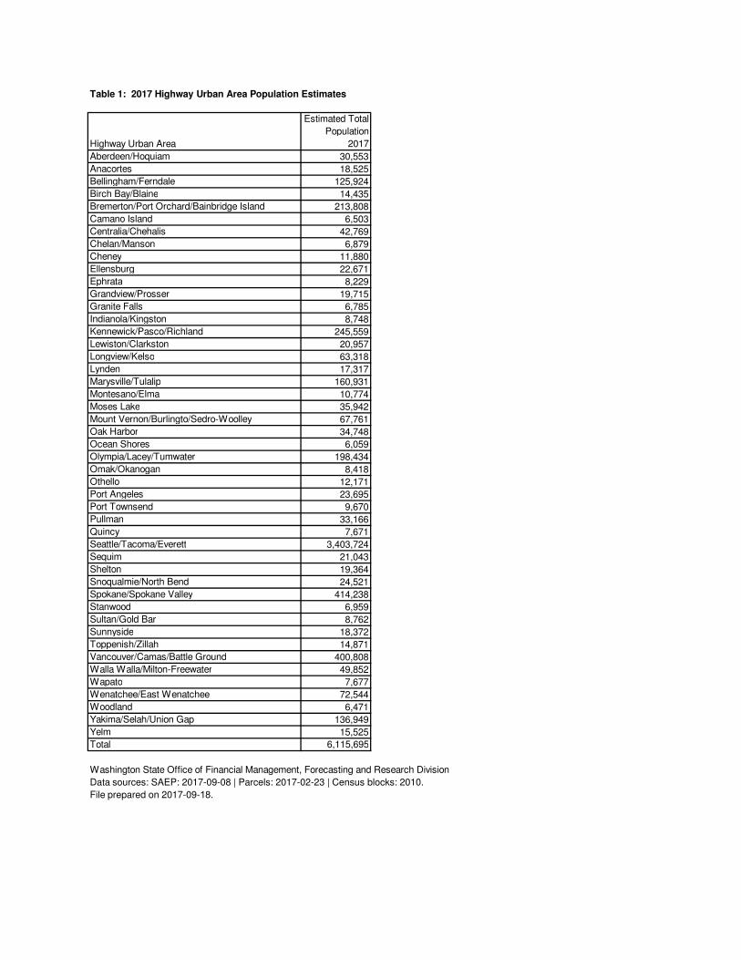
Table 1: 2017 Highway Urban Area Population Estimates
Highway Urban Area
Estimated Total
Population
2017
Aberdeen/Hoquiam 30,553
Anacortes 18,525
Bellingham/Ferndale 125,924
Birch Bay/Blaine 14,435
Bremerton/Port Orchard/Bainbridge Island 213,808
Camano Island 6,503
Centralia/Chehalis 42,769
Chelan/Manson 6,879
Cheney 11,880
Ellensburg 22,671
Ephrata 8,229
Grandview/Prosser 19,715
Granite Falls 6,785
Indianola/Kingston 8,748
Kennewick/Pasco/Richland 245,559
Lewiston/Clarkston 20,957
Longview/Kelso 63,318
Lynden 17,317
Marysville/Tulalip 160,931
Montesano/Elma 10,774
Moses Lake 35,942
Mount Vernon/Burlingto/Sedro-Woolley 67,761
Oak Harbor 34,748
Ocean Shores 6,059
Olympia/Lacey/Tumwater 198,434
Omak/Okanogan 8,418
Othello 12,171
Port Angeles 23,695
Port Townsend 9,670
Pullman 33,166
Quincy 7,671
Seattle/Tacoma/Everett 3,403,724
Sequim 21,043
Shelton 19,364
Snoqualmie/North Bend 24,521
Spokane/Spokane Valley 414,238
Stanwood 6,959
Sultan/Gold Bar 8,762
Sunnyside 18,372
Toppenish/Zillah 14,871
Vancouver/Camas/Battle Ground 400,808
Walla Walla/Milton-Freewater 49,852
Wapato 7,677
Wenatchee/East Wenatchee 72,544
Woodland 6,471
Yakima/Selah/Union Gap 136,949
Yelm 15,525
Total 6,115,695
Washington State Office of Financial Management, Forecasting and Research Division
Data sources: SAEP: 2017-09-08 | Parcels: 2017-02-23 | Census blocks: 2010.
File prepared on 2017-09-18.
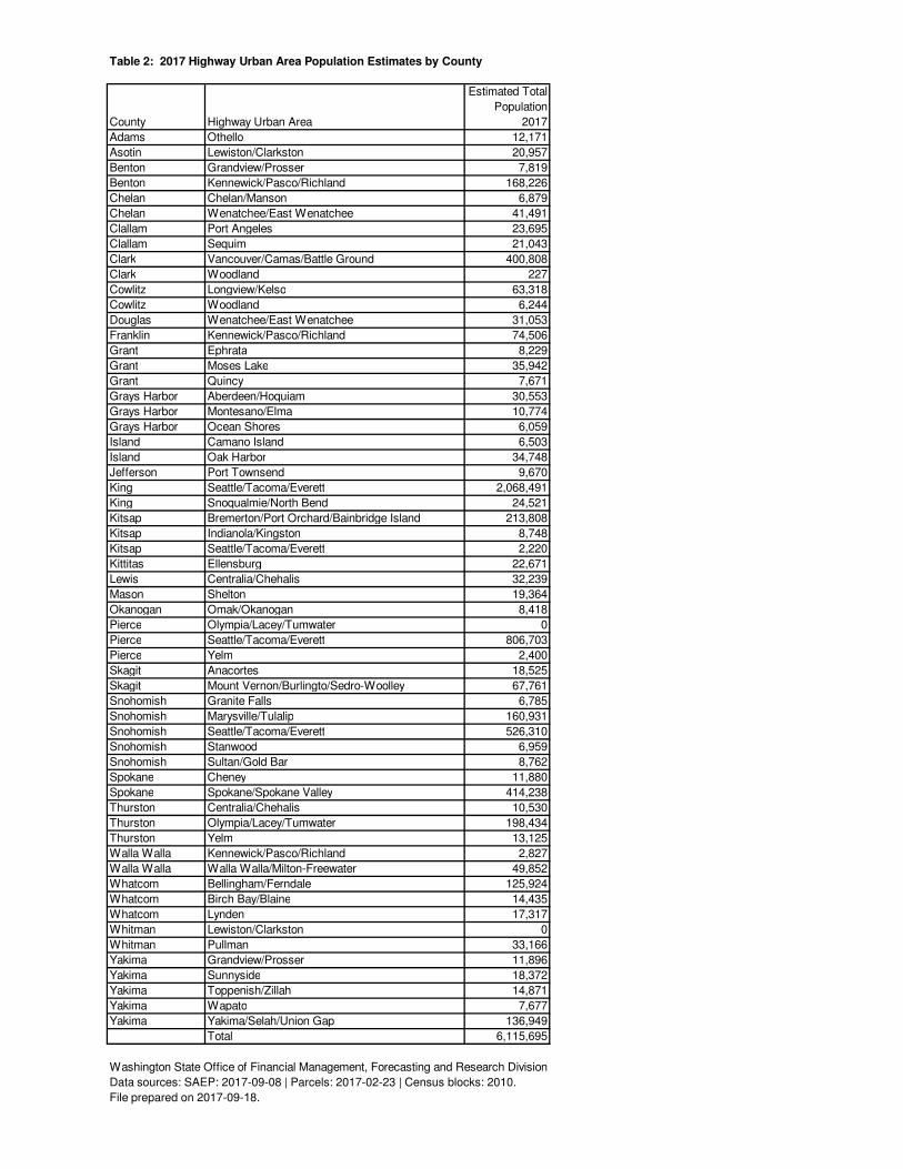
Table 2: 2017 Highway Urban Area Population Estimates by County
County Highway Urban Area
Estimated Total
Population
2017
Adams Othello 12,171
Asotin Lewiston/Clarkston 20,957
Benton Grandview/Prosser 7,819
Benton Kennewick/Pasco/Richland 168,226
Chelan Chelan/Manson 6,879
Chelan Wenatchee/East Wenatchee 41,491
Clallam Port Angeles 23,695
Clallam Sequim 21,043
Clark Vancouver/Camas/Battle Ground 400,808
Clark Woodland 227
Cowlitz Longview/Kelso 63,318
Cowlitz Woodland 6,244
Douglas Wenatchee/East Wenatchee 31,053
Franklin Kennewick/Pasco/Richland 74,506
Grant Ephrata 8,229
Grant Moses Lake 35,942
Grant Quincy 7,671
Grays Harbor Aberdeen/Hoquiam 30,553
Grays Harbor Montesano/Elma 10,774
Grays Harbor Ocean Shores 6,059
Island Camano Island 6,503
Island Oak Harbor 34,748
Jefferson Port Townsend 9,670
King Seattle/Tacoma/Everett 2,068,491
King Snoqualmie/North Bend 24,521
Kitsap Bremerton/Port Orchard/Bainbridge Island 213,808
Kitsap Indianola/Kingston 8,748
Kitsap Seattle/Tacoma/Everett 2,220
Kittitas Ellensburg 22,671
Lewis Centralia/Chehalis 32,239
Mason Shelton 19,364
Okanogan Omak/Okanogan 8,418
Pierce Olympia/Lacey/Tumwater 0
Pierce Seattle/Tacoma/Everett 806,703
Pierce Yelm 2,400
Skagit Anacortes 18,525
Skagit Mount Vernon/Burlingto/Sedro-Woolley 67,761
Snohomish Granite Falls 6,785
Snohomish Marysville/Tulalip 160,931
Snohomish Seattle/Tacoma/Everett 526,310
Snohomish Stanwood 6,959
Snohomish Sultan/Gold Bar 8,762
Spokane Cheney 11,880
Spokane Spokane/Spokane Valley 414,238
Thurston Centralia/Chehalis 10,530
Thurston Olympia/Lacey/Tumwater 198,434
Thurston Yelm 13,125
Walla Walla Kennewick/Pasco/Richland 2,827
Walla Walla Walla Walla/Milton-Freewater 49,852
Whatcom Bellingham/Ferndale 125,924
Whatcom Birch Bay/Blaine 14,435
Whatcom Lynden 17,317
Whitman Lewiston/Clarkston 0
Whitman Pullman 33,166
Yakima Grandview/Prosser 11,896
Yakima Sunnyside 18,372
Yakima Toppenish/Zillah 14,871
Yakima Wapato 7,677
Yakima Yakima/Selah/Union Gap 136,949
Total 6,115,695
Washington State Office of Financial Management, Forecasting and Research Division
Data sources: SAEP: 2017-09-08 | Parcels: 2017-02-23 | Census blocks: 2010.
File prepared on 2017-09-18.

Adams
Asotin
Benton
Chelan
Clallam
Clark
Columbia
Cowlitz
Douglas
Ferry
Franklin Garfield
Grant
Grays Harbor
Island
Jefferson
King
Kitsap
Kittitas
Klickitat
Lewis
Lincoln
Mason
Okanogan
Pacific
PendOreille
Pierce
San Juan
Skagit
Skamania
Snohomish
Spokane
Stevens
Thurston
Wahkiakum
Walla Walla
Whatcom
Whitman
Yakima
Aberdeen/Hoquiam
Anacortes
Bellingham/Ferndale
Birch Bay/Blaine
Bremerton/Port Orchard/
Bainbridge Island
Camano Island
Centralia/Chehalis
Chelan/Manson
Cheney
Ellensburg
Ephrata
Grandview/Prosser
Granite Falls
Indianola/Kingston
Kennewick/Pasco/Richland
Lewiston/Clarkston
Longview/Kelso
Lynden
Marysville/Tulalip
Moses Lake
Mount Vernon/Burlingto/
Sedro-WoolleyOak Harbor
Ocean ShoresOlympia/Lacey/
Tumwater
Omak/Okanogan
Othello
Port Angeles
Port Townsend
Pullman
Quincy
Seattle/Tacoma/Everett
Sequim
Shelton
Snoqualmie/North Bend
Spokane/Spokane Valley
Stanwood
Sultan/Gold Bar
SunnysideToppenish/Zillah
Vancouver/Camas/Battle Ground
Walla Walla/Milton-Freewater
Wapato
Wenatchee/East Wenatchee
Woodland
Yakima/Selah/
Union Gap
Yelm
Highway Urban Area
County2017 Highway Urban Areas
Source: Washington State Department of Transportation (2013). Highway Urban Areas [Shapefile].
State of WashingtonOffice of Financial Management
Forecasting and Research Division
Map prepared on 2017-09-18.