State of Rhode Island · DIVISION OF PLANNING | 1 The Rhode Island Statewide Planning Program in...
54
State of Rhode Island Highway Functional Classification 2014 Statewide Planning Program Technical Paper #165 July 2014 Rhode Island Department of Administration Division of Planning Statewide Planning Program One Capitol Hill, Providence, RI 02908 www.planning.ri.gov
Transcript of State of Rhode Island · DIVISION OF PLANNING | 1 The Rhode Island Statewide Planning Program in...

State of Rhode IslandHighway Functional Classification 2014
Statewide Planning Program Technical Paper #165July 2014
Rhode Island Department of AdministrationDivision of PlanningStatewide Planning ProgramOne Capitol Hill, Providence, RI 02908www.planning.ri.gov


DIVISION OF PLANNING |1
The Rhode Island Statewide Planning Program in the Division of Planning, Department of Administration, is established by Chapter 42-11 of the General Laws as the central planning agency for state government. The work of the Program is guided by the State Planning Council, comprised of state, local, and public representatives and federal and other advisors.
The objectives of the Program are: (1) to prepare strategic and systems plans for the state; (2) to coordinate activities of the public and private sectors within this framework of policies and programs; (3) to assist local governments in management, finance, and planning; and (4) to advise the Governor and others on physical, social, and economic topics.
This Technical Paper is one of a series prepared by the Statewide Planning Program. Technical Papers present information developed through planning activities to state and federal agencies, local governments, and the public.
Activities of the Program are supported by state appropriations and federal grants. The contents of this report reflect the views of the Statewide Planning Program which is responsible for the accuracy of the facts and data presented herein. The contents do not necessarily reflect the official views or policies of other sponsoring agencies. This publication is based upon publicly supported research and may not be copyrighted. It may be reprinted, in part or full, with the customary crediting of the source.
Copies of this report are available on the web at www.planning.ri.gov. For hard copies, contact the Statewide Planning Program, One Capitol Hill, Providence, RI, (401) 222-7901.
TITLE VI - RHODE ISLAND STATEWIDE PLANNING PROGRAM’S NOTICE TO BENIFICIARIES
The Division of Planning’s Statewide Program (SPP) operates its programs, services, and activities in compliance with federal nondiscrimination laws including Title VI of the Civil Rights Act of 1964, the Civil Rights Restoration Act of 1987, and related statutes and regulations. Title VI prohibits discrimination in federally assisted programs and requires that no person in the United States shall, on the grounds of race, color, or national origin (including limited English proficiency), be excluded from participation in, be denied the benefits of, or be otherwise subjected to discrimination under any program or activity receiving federal assistance. Related federal nondiscrimination laws administrated by the Federal Highway Administration, the Federal Transit Administration, or both prohibit discrimination on the basis of age, sex, and disability. These protected categories are contemplated within the SPP’s Title VI Program consistent with federal interpretation and administration. Additionally, the SPP provides meaningful access to its programs, services, and activities to individuals with limited English proficiency, in compliance with US Department of Transportation policy and guidance on federal Executive Order 13166.
To request additional information about the Statewide Planning Program’s Civil Rights obligations please contact Michael C. Moan, Title VI Coordinator at [email protected] or (401) 222-1236. Persons wishing to file complaints under Title VI should do so within 180 days of the alleged occurrence. Complaints that are submitted in writing to the Title VI Coordinator should use the Title VI Discrimination Complaint Form available at www.planning.ri.gov/documents/trans/TitleVI.pdf, or by contacting Mr. Moan at the above telephone or email address. Reasonable accommodations will be provided to anyone needing assistance due to physical, sensory impairments or a disability to request information or file a complaint. This assistance is available by contacting James A. Pitassi, Jr. at 222-6395 (voice) or #711 (R.I. Relay).

DIVISION OF PLANNING|2
PREFACE
The Rhode Island Statewide Planning Program, working in cooperation with the Rhode Island Department of Transportation (RIDOT), conducted a comprehensive review and update to the State’s highway functional classification system as required by the Federal Highway Administration (FHWA). A roadway’s functional classification is based upon its level of travel mobility and access to property according to a hierarchy of travel service it provides. It defines the role a road plays in the nation’s highway network, whether a road is eligible for federal funding, and it provides a way for transportation agencies to track roadway system performance and condition. Beginning in September 2013, Statewide Planning and RIDOT followed the process described in FHWA’s Highway Functional Classification Concepts, Criteria and Procedures, 2013 Edition to review every public roadway in the state. As a result Statewide Planning and RIDOT proposed 429 roadway segments, totaling 196.4 miles, for reclassification.
In previous years, the statewide reclassification effort had limited impact on Rhode Island’s municipalities. However under the July 2012 federal transportation authorization Moving Ahead for Progress in the 21st Century (MAP-21), states that use federal funds for transportation projects are now required to prioritize resources towards maintaining the condition and performance of roadways on the National Highway System (NHS). The NHS consists of those roads deemed most important to the economy, defense, and mobility of the nation, primarily Principal Arterials including roadways classified as Interstates, Other Freeway and Expressways, and Other Principal Arterials. Under MAP-21 a roadway’s functional classification will now have increased importance when the state determines project priority under the next Transportation Improvement Program (TIP).
In addition to the implications for federal/state funding priority, roadways on the NHS are subject to FHWA’s NHS construction design standard requirements, specified maintenance requirements, control of outdoor advertising and junkyards along highways, contract administration standards, safety specifications, and asset management accountability. As a result of the proposed functional classification upgrades and downgrades, three reclassification scenarios were particularly noteworthy: upgrades that moved roads onto the NHS, downgrades that removed roads from the NHS, and downgrades that removed roads’ eligibility for federal funds.
Through Rhode Island’s comprehensive review of its highway functional classification system, the state added a net total of 68.5 miles to the National Highway System, and it made 40.8 new miles of roadway eligible for federal funding. None of the changes has an impact on projects listed in Rhode Island’s FY 2013-2016 Transportation Improvement Program.

DIVISION OF PLANNING |3
LIST OF TABLES
Table 1: Functional Classification Factors...................................................................5Table 2: Functional Classifications...............................................................................7Table 3: Functional Classification Changes.................................................................15Table 4: Functional Classification Changes: Urban-Rural Comparison..................15
TABLE OF CONTENTS
Preface..............................................................................................................................2List of Tables....................................................................................................................3List of Figures..................................................................................................................3
Highway Functional Classification..............................................................................4Rhode Island Functional Classification 2014.............................................................9Conclusion......................................................................................................................14
Appendices1. Municipal Letter and Information2. Municipal Comments and Responses3. Transportation Advisory Committee Comments and Responses4. Highway Functional Classification Changes5. Highway Functional Classification Map
LIST OF FIGURES
Figure 1: Mobility - Access Continuum......................................................................5Figure 2: Rhode Island Adjusted Urban Boundary....................................................8Figure 3: Map of Traffic Generators.............................................................................11Figure 4: Rhode Island Functional Classification System.........................................16
DIVISION OF PLANNING|4
HIGHWAY FUNCTIONAL CLASSIFICATION
Highway Functional Classification is the process through which the states, as required by the United States Department of Transportation’s (USDOT) Federal Highway Administration (FHWA) define the role every public road plays in the nation’s highway network. Using a consistent system, they classify each roadway into a hierarchy of types with three levels: arterial, collector, and local, which are classified further as “urban” or “rural.” The classification system determines what types of federal funding a roadway qualifies for, and it is also the primary way in which transportation agencies track roadway system performance, benchmarks, and targets. A road’s functional classification does not dictate its design. Functional classification will increase in importance as states use a roadway’s classification to set expectations and measure preservation, mobility, and safety outcomes in their move towards the performance-based management of transportation systems required under MAP-21.
Also important is the connection between functional classification and the National Highway System (NHS). The NHS is composed of roadways important to the nation’s economy, defense, and mobility; it includes interstates, intermodal connectors such as train stations and airports, the Strategic Highway Network, and major strategic highway connectors. Roadways in the NHS must comply with federal requirements on design standards, contract administration, data collection, state-FHWA oversight, and outdoor advertisement and junkyard control. In 2012 MAP-21 expanded the NHS to include all principal arterials. It also requires states to prioritize resources toward the NHS. For Rhode Island this resulted in the addition of 306 miles of roadways to the NHS,which are now subject to higher standards and oversight.
DETERMINING FUNCTIONAL CLASSIFICATION
The most important factor in determining the role a road plays in the system and thus its place in the hierarchy of types (arterial, collector, or local) is its function. Generally roads serve two primary functions: access and mobility.
• Roadway access function: Provides many opportunities for entry and exit, which creates potentially higher friction from vehicle access/egress.
• Roadway mobility function: Provides few opportunities for entry and exit and therefore low travel friction from vehicle access/egress.
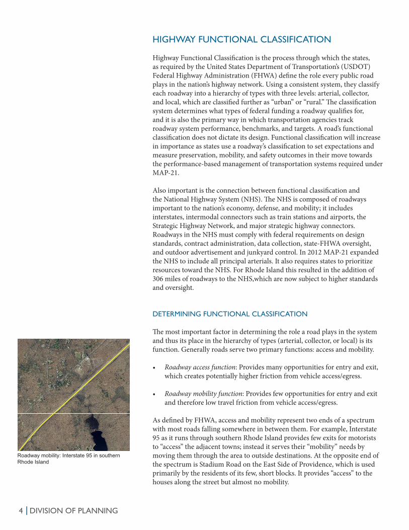
As defined by FHWA, access and mobility represent two ends of a spectrum with most roads falling somewhere in between them. For example, Interstate 95 as it runs through southern Rhode Island provides few exits for motorists to “access” the adjacent towns; instead it serves their “mobility” needs by moving them through the area to outside destinations. At the opposite end of the spectrum is Stadium Road on the East Side of Providence, which is used primarily by the residents of its few, short blocks. It provides “access” to the houses along the street but almost no mobility.
Roadway mobility: Interstate 95 in southern Rhode Island

DIVISION OF PLANNING |5
The three broad highway functional classifications can be positioned along the mobility-access spectrum. Generally, arterials provide better mobility, and local roads provide better access. Collectors offer a combination of both. Figure 1 shows how the classifications serve each function.
Roadway access: Stadium Road in Providence
Functional Classification
Distance Served
Access Points Speed Limit
Route Spacing Usage Significance
Number of Travel Lanes
Arterial Longest Few Highest Longest Highest Statewide More
Collector Medium Medium Medium Medium Medium Medium Medium
Local Shortest Many Lowest Shortest Lowest Local Fewer
FIGURE 1: Mobility - Access Continuum
TABLE 1: Functional Classification Factors
Mobility
Access
ArterialsCollectorsLocals
Mobility and access are not the only factors that determine the role and classification of a roadway. Also important are:
• Distance served: Whether a roadway serves primarily long- or short-distance trips.
• Access points: The amount of direct access a roadway provides to adjacent destinations such as homes and businesses.
• Speed limit: Whether a roadway allows for high-speed or lower-speed travel.
• Route spacing: Arterials, connectors, and local roads should be spaced regularly and logically.
• Usage: The amount travelers use a roadway as measured by annual average daily traffic (AADT) and daily vehicle miles of travel (DVMT).
• Significance: The importance of a roadway to regional and statewide travel.• Number of travel lanes: Whether a road has a greater or fewer number of
travel lanes.
No one factor determines the functional classification of a road; multiple factors should be considered. The goal is to define through functional classification a continuous system in which traffic moves back and forth from arterials to collectors to locals. Table 1 describes the relationship between the functional classification categories and the factors described above.

DIVISION OF PLANNING|6
FUNCTIONAL CLASSES
Arterials, collectors, and locals are the three major categories used in the functional classification of roadways, but FHWA also requires states to stratify roads into a set of sub-categories based on their role and function. A further refinement is the separation of the classified roadways into “urban” and “rural,” based on the area they serve (See the Urban Boundary section on page 8 for more information). Previously FHWA specified different classifications in urban and rural areas, but now the same classifications exist in both. Although the distinctions between the various functional classifications can be ambiguous in some instances, each can be defined by a set of characteristics.
ArterialsArterials are at the highest level of the highway functional classification system. They are roadways that provide a high level of mobility, have high speed limits, carry high traffic volumes, and allow for long-distance, uninterrupted travel. They connect states, regions, and urban centers, and they usually have multiple lanes and offer some access control such as the interchanges on an interstate. FHWA separates arterials into the following sub-categories.
Principal Arterials• Interstates: All parts of the Interstate Highway System are classified as
interstates. In Rhode Island, this includes Interstates 95, 195, and 295.
• Other Freeways and Expressways: These roadways are similar to interstates; they offer high mobility and limited access with high speed limits and physically-divided lanes. Rhode Island examples are Routes 10 and 146.
• Other Principal Arterials: These roadways also offer high levels of mobility, but they provide direct access to adjacent homes and businesses. Examples are North Main Street in Providence and Route 6 west of Interstate 295.
Minor ArterialsMinor arterials connect and support the system of principal arterials, serving trips of moderate length at lower speeds. In rural areas, they link cities and larger towns. Minor arterials in Rhode Island include Atwells Avenue in Providence and Route 101 in Scituate and Foster.
CollectorsCollectors’ primary role is to distribute traffic from local roads onto arterials and from arterials to local roads. They provide more access to adjacent homes and businesses than arterials but more mobility than local roads. Within urban areas they may link neighborhoods and districts, and in rural areas, they link towns and agricultural areas not served by arterials. Typically, collectors have two lanes and pavement markings.
Major CollectorsMajor collectors serve both traffic circulation and access needs. In urban areas they distribute trips between local roads and arterials over greater distances than minor collectors. In rural areas they link larger communities not served by an arterial. Examples of urban and rural major collectors are Eaton Street in Providence and Meetinghouse Lane in Little Compton, respectively.
MAP-21 declared that all principal arterials are part of the National Highway System.
Other Freeway and Expressway:Route 6 and Route 10 Interchange
Major Collector: Easton Street in Providence

DIVISION OF PLANNING |7
Minor CollectorsThe role of minor collectors is similar to major collectors, but they connect arterials and local roads over shorter distances and serve lower density areas. Generally they have lower speed limits than major collectors, and in rural areas they serve smaller communities than major collectors. Third Street in Newport is an example of an urban minor collector, and Plain Meetinghouse Lane in West Greenwich is a rural minor collector.
LocalsLocal roads are at the bottom of the functional classification hierarchy, although they comprise the largest percentage of all roadways in the state . Their role is to provide access to homes and businesses; they have low speed limits and offer limited mobility for through traffic. Examples of local streets include Fairweather Avenue in Cranston and Leonard Terrace in Newport.
National Highway System and Federal Aid EligibilityThe NHS includes interstates, other freeways and expressways, and as of 2010, other principal arterials. All classifications are federal-aid eligible EXCEPT for rural minor collectors and urban and rural local roadways. Table 2 shows each functional classification system category and its relation to the NHS and federal aid eligibility.
Local Road: Leonard Terrace in Newport
URBAN RURAL
Arterial Principal Arterials Principal Arterials
Interstates Interstates
Other Freeways/Expressways Other Freeways/Expressways
Other Principal Arterials Other Principal Arterials
Minor Arterials Minor Arterials
Collector Major Collectors Major Collectors
Minor Collectors Minor Collectors
Local Local Roads Local Roads
TABLE 2: Functional Classifications
NHS
Federal-aid eligible

DIVISION OF PLANNING|8
URBAN BOUNDARY
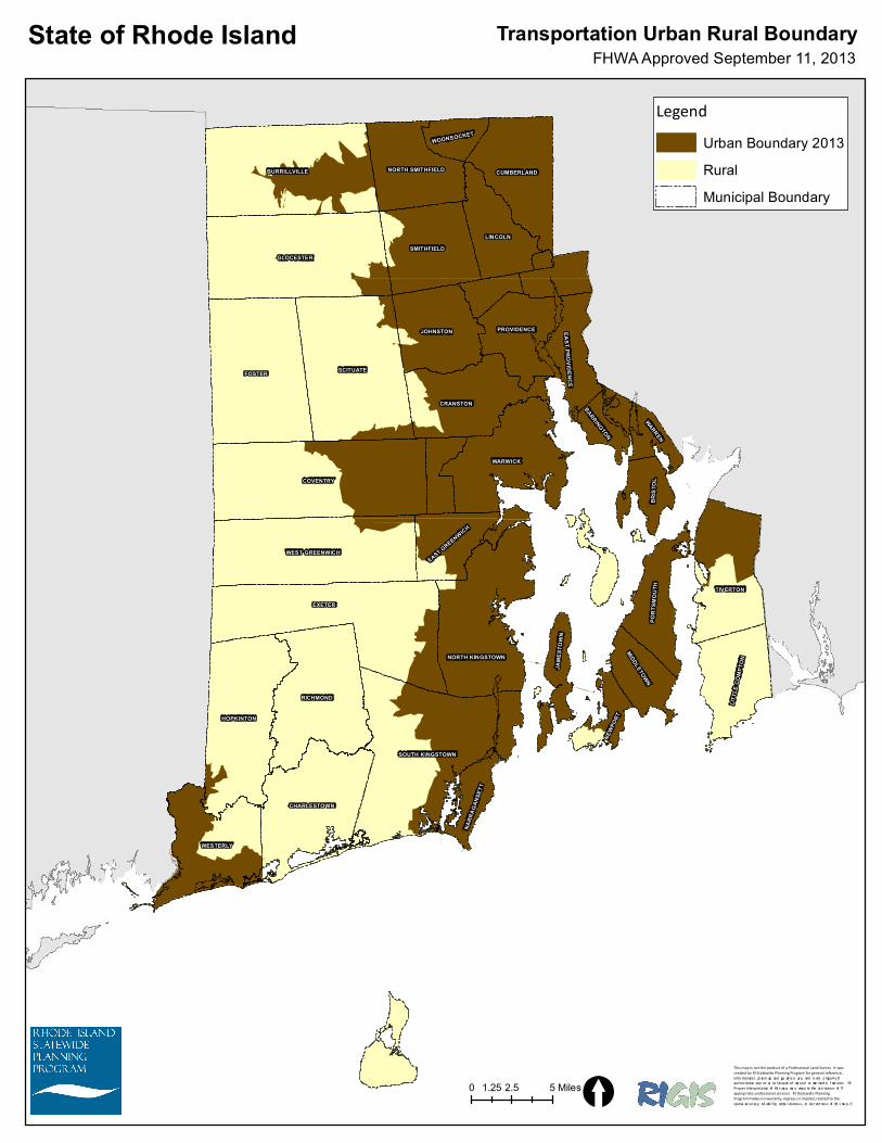
As part of the Highway Functional Classification process, all roadways must be categorized as either “urban” or “rural.” The determination is made using the urban area boundary, a spatial designation that the U.S. Census Bureau develops through the decennial census for every part of the country with a population greater than 50,000. FHWA gives states the option of using the urban boundary area determined by the Census Bureau or adjusting the boundary to account for inconsistencies with the transportation system and to maximize geographic continuity. In 2013 Statewide Planning and RIDOT used the 2010 U.S. Census urban area boundary and adjusted it for transportation purposes only by reducing irregularities to allow the state to make better use of the federal funds allocated to rural roadways. Figure 2 shows Rhode Island’s adjusted transportation urban area boundary.
Urban Boundary 2013
[4 Miles
FIGURE 2: Rhode Island Adjusted Urban Boundary

DIVISION OF PLANNING |9
RHODE ISLAND FUNCTIONAL CLASSIFICATION 2014
Statewide Planning and RIDOT began a review of the functional classification of Rhode Island’s roadways in July 2013. Staff recognized that changes since the previous classification in 2005, the adjusted urban area boundary, and new guidance from FHWA would require a careful look at the state’s roadway system. As a guide they used FHWA’s Highway Functional Classification Concepts, Criteria and Procedures 2013 Edition, which defines and describes a method for classifying roadways as arterials, collectors, and locals. The two agencies organized a team of staff members and worked internally to develop a draft list of roadways proposed for functional re classification. After a period of review and comment by Rhode Island’s municipalities and neighboring states, the agencies finalized the functional classification with the approval by the Transportation Advisory Committee, and they submitted it to FHWA in August 2014 for final approval.
FHWA’s method for the functional classification of roadways relies on three basic steps.
• Identification and connection of traffic generators i.e. important destinations such as shopping centers and hospitals.
• Creation of a coherent network of roadways that facilitates direct, continuous movement among destinations within Rhode Island.
• Establishment of a logical hierarchy of roads based so that there are more local roads than collectors and more collectors than arterials.
FHWA recommends that states start at the top of the highway hierarchy and identify the principal arterials that link the most important destinations and then move down through connectors and locals and lesser destinations so as to create a continuous network, always considering the specific characteristics of each roadway class.
Based on FHWA’s guidance, Planning and RIDOT followed the steps below in the development of the state’s highway functional classification.
Organization and Preparation
• Identify and organize internal team: Statewide Planning and RIDOT assembled an internal team to lead the reclassification; its membership was composed of staff in Statewide Planning’s transportation section and staff from RIDOT. The group met regularly beginning in July 2013 to review progress and make decisions.
• Establish project timeline and define responsibilities: The functional classification team set an aggressive schedule for the completion of Rhode Island’s reclassification. It began the process in September 2013 and completed it in July 2014. The group also agreed on a technical approach to the update and assigned tasks to specific staff members.
• Confirm standards and existing data: The first, important task in the update was to assemble the baseline data for the reclassification. Staff at

DIVISION OF PLANNING|10
Statewide Planning and RIDOT worked together to check the consistency and accuracy of the state’s GIS road layer. They identified and resolved inconsistencies between the state’s GIS roadway layer and the published municipal highway functional classification maps; they made sure that every road segment had a classification, incorporated changes made since the most recent reclassification in 2005; and they revised the GIS file to account for changes made to the state’s urban-rural boundary in 2013. They also incorporated estimates of annual average daily traffic in order to calculate daily VMTs where possible. The result was a single GIS layer that the team could use to begin the reclassification process.
Developing the Functional Classification System
• Identify traffic generators: Statewide Planning identified twenty-one types of generators, including shopping centers, airports, major private and government employers, hospitals, colleges and schools, state-identified growth centers, trains stations and bus hubs, military bases, and industrial areas.
• Rank traffic generators: The team ranked each of the traffic generator types as high, medium, or low based on their impact on traffic. It estimated traffic impact using a combination of factors, including traffic volumes on nearby roads and the size and capacity of the facility or site in question. For instance the team classified hospitals with more than 200 beds, such as Rhode Island Hospital, as “high” and hospitals with 60-200 beds as “medium.”
• Map traffic generators: Statewide Planning and RIDOT mapped the traffic generators, using existing layers from the Rhode Island Geographical Information System as well as some it created specifically for the effort. Figure 3 shows the location of the traffic generators used in the analysis.
• Connect traffic generators: Planning and RIDOT reviewed the resulting map and determined the appropriate functional classification to link the various traffic generators. They also layered the 2005 functional classification on top of the generators to identify mismatches and inconsistencies. For example, they changed the classification of Twin River Road, which provides access to Twin River Casino from major collector to a minor arterial to account for increased traffic to the casino and improvements to the road. As recommended by FHWA they began with the roads at the top of the functional classification hierarchy and moved down until only local roads remained. In determining a roadway’s classification, they used the FHWA criteria described in the Determining Functional Classification section of this report.
• Create coherent network: The team reviewed the result of the functional classification to ensure that the roadways formed a coherent network that would allow for continuous, direct movement among the traffic generators. They revised the system to ensure that travelers could move in, out, and through the state’s urban centers on arterials and that, where possible, arterials and collectors did not have “dead ends” or dangling sections.

DIVISION OF PLANNING |11
• Establish logical hierarchy: At the same time, the team reviewed the proposed road classifications to make sure that the system comprised a hierarchy with roads used primarily for mobility at the top and those providing access at the bottom. It reclassified roads as necessary to ensure the appropriate balance between classifications, so that the state and its municipalities and neighborhoods were served by a logical network which allowed movement among arterials, collectors, and local roads.
• National Highway System: Changes driven by MAP-21 have made whether or not a road is on the NHS more significant than it was previously. Statewide Planning and RIDOT paid special attention to roadways coming on or off the NHS, and they reviewed the entire proposed NHS system carefully to ensure that it formed a logical network that allowed travelers to move among Rhode Island’s major traffic generators and its urban centers.
FIGURE 3: Map of Traffic Generators
[5 Miles
Large Generator
Medium Generator
Small Generator
LEGEND
!!
!
!!
!
!
!
!!
!
!
!
!
!!
!
!
!
!
!
!
!
!!
!
!
!
!! !! !
!! !
!
!!
!!
!
!
!!! !
!
!
!
!
!
!
!
!
! !!
!
!
!!
!
!
!
!
!
!
!
!
!
!!
!
!
!
!!
!
!!
!!! !
!
!
!!
!
!
!
!!!
!
!
!
!!
!
!
!
!!
!!
!
!!
!!
!
!
!!
!
!
!!!
!
!
!!
!
!!
!
!!
!
!!
!
!!!
!!
!
!
!!
!
!
!!!
!!
!
!
!
!
!
!
!
!
!
!
!!
! !
!
!
!
!
!
!
!!!
!
!!
!
!
!
!
!
!
!
!
!
!
!
!
!
!
!
!
!
!
!
!
!
!!
!
!
!
!
!
!
!
!
!
!
!
!
!
!
!
!
!
!
!
!
!
!
!
!!
!
!
!
!
!
!
!
!
!
!
!
!
!
!
!
!
!
!
! !
!
!!
!
!
!
!
!!
!
!
!
!
!
!
!
!
!
!
!
!
!
!
!
!
!
!
!
!
!
!
!
!
!
!
!!
!
!!
!
!
!
!
!!
!!
!
!!
!
!!
!
!
!
!
!
!!
!
!
!
!
!
!
!
!
!
!
!!
!
!
!!
!
!
!
!
!!
!
!
! ! !!
!
!
!
!!
!
!
!
!
!!!
!
!
!
!
!
!
!
!
!!
!
!
!
!
!
!
!
!
!
!
!
!
!
!
!
!
!
!
!
!
!!
!
!
!
!
!
!
!
!
!
!!
!
!
!
!
!
!
!
!
!
!
!
!!
!!
!
!
!
!
!
!
!
!

DIVISION OF PLANNING|12
• Draft functional classification: Planning and RIDOT used an iterative process of map review and meetings to refine and eventually come to a consensus on the functional classification of the state’s roadways. Statewide Planning staff created a table and linked a GIS shapefile that listed the classification and urban/rural designation of every roadway in the state and identified those segments for which the classification changed. It used the data in the table to produce summaries of the functional classification changes for the state as a whole and for each municipality.
Review and Comment
• Municipal communication: Once the Statewide Planning and RIDOT team completed its draft list of functional classification changes, it sent letters to the state’s 39 municipalities informing them of the proposed changes, explaining the reclassification’s significance, and requesting comments. The letter directed municipalities to Statewide Planning’s web site http://www.planning.ri.gov/statewideplanning/transportation/highway.php, where they could view and download tables listing the proposed changes in each municipality as well as maps of the existing and proposed functional classification systems. It highlighted four reclassification scenarios as particularly important:
• Upgrades to Other Principal Arterials and above and therefore part of the NHS
• Downgrades from Other Principal Arterials and above to Minor Arterial and below, therefore removed from the NHS
• Downgrades from Urban - Minor Collector and above to Urban Local and thus not federal-aid eligible
• Downgrades from Rural – Major Collector and above to Rural - Minor Collector or Local and thus not federal-aid eligible
Statewide Planning sent the municipal letters on June 3, 2014 and requested comments from municipalities by June 26, 2014. Appendix 1 contains copies of the materials sent to municipalities.
• Municipal meetings and regional workshops: Statewide Planning and RIDOT also organized four regional workshops throughout the state in June 2014 to provide additional opportunities for municipalities to discuss and learn about the proposed functional classification changes: Kent County (June 17), Washington County (June 24), Newport County (June 25), and Providence Metro and Northern Rhode Island (June 25). At each workshop, Statewide Planning presented on the changes and provided time for municipal representatives to review the maps and tables and comment on the proposed changes. The Statewide Planning and RIDOT team also met individually with the four municipalities with the greatest number of proposed changes: Newport, Pawtucket, Providence, and Woonsocket.
• Municipal comments: Statewide Planning received written comments on the proposed changes from the City of Newport, the Quonset Development Corporation, the Town of Smithfield, and the City of Woonsocket. Statewide Planning and RIDOT reviewed all of the comments submitted

DIVISION OF PLANNING |13
on the proposed classification changes and provided a response for each comment. A list of the comments received and the state’s responses is included as Appendix 2.
• Communication with Massachusetts and Connecticut: FHWA requires roads that cross state lines have the same functional classification on both sides of the border. To ensure that Rhode Island’s reclassification was coordinated with its neighbors, Statewide Planning contacted the Massachusetts and Connecticut Departments of Transportation requesting written comments on the proposed changes. ConnDOT responded that it had no comments; MassDOT did not respond.
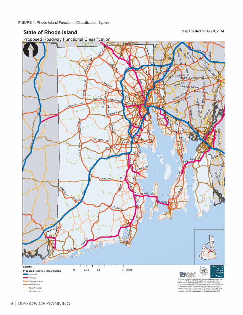
Incorporate changes and refine maps: After the team’s review of the comments, it revised the proposed functional classification system as appropriate to incorporate them. Once the team completed its changes, Statewide Planning produced a new set of maps and tables that describe the final functional classification. Table 3 shows the final mileage total and percentages for each functional classification category for the current (2014) and previous (2005) reclassifications, and Figure 4 shows the statewide functional classification system. A complete list of the changes is included in Appendix 4.
Finalization and Submission
• Transportation Advisory Committee: The Transportation Advisory Committee is the body charged with reviewing and approving the changes to Rhode Island’s highway functional classification system before their submission to FHWA. Statewide Planning presented to the Transportation Advisory Committee twice on the functional classification changes: once at the committee’s June 26, 2014 meeting and again at its July 24, 2014 meeting. At the first meeting, Statewide Planning described the reclassification process and purpose and accepted public comments on the proposed changes; at the second meeting, it presented the final, revised highway functional classification system, and the committee voted to approve the changes.
• FHWA Submission: Statewide Planning and RIDOT submitted the final, approved functional classification changes to the FHWA Rhode Island Division and the NHS changes to FHWA headquarters in Washington D.C. in a geospatial format and as hard copy maps.
DIVISION OF PLANNING|14
CONCLUSION
Tables 3 and 4 summarize the final 2014 Rhode Island Highway Functional Classification System and compares it to the 2013 version. Overall, the changes are minor. The state added a net total of 68.5 miles to the National Highway System, and it made 40.8 new miles of roadway eligible for federal funding. None of the changes has an impact on projects listed in Rhode Island’s FY 2013-2016 Transportation Improvement Program, although functional classification will play a larger role in the determination of project priority in the next TIP. As discussed earlier, MAP-21 requires states to report on the condition and performance of their NHS roads, providing incentives for states to prioritize those roads as they determine the allocation of limited transportation resources. Rhode Island’s updated highway functional classification system will also be useful as the state sets expectations and measures preservation, mobility, and safety outcomes in its move towards performance-based management of its transportation system.

DIVISION OF PLANNING |15
TABLE 3: Functional Classification Changes
TABLE 4: Functional Classification Changes: Urban - Rural Comparison
ChangeMiles % Miles %
RuralInterstate 36.4 2.3% 0.0 36.4 2.3%Other Freeways & Expressways 29.3 1.8% 10.7 40.0 2.5%Other Principal Arterial 60.8 3.8% 27.5 88.3 5.5%Minor Arterial 94.7 5.9% ‐21.7 73.0 4.6%Major Collector 200.7 12.6% ‐10.9 189.7 11.9%Minor Collector 121.2 7.6% 10.3 131.5 8.2%Local 1,050.7 65.9% ‐15.9 1,034.8 64.9%UrbanInterstate 53.6 1.1% 0.0 53.6 1.1%Other Freeways & Expressways 81.7 1.7% 3.3 85.0 1.7%Other Principal Arterial 350.2 7.1% ‐2.6 347.6 7.0%Minor Arterial 332.3 6.7% 16.6 348.9 7.1%Major Collector 556.3 11.3% ‐19.5 536.9 10.9%Minor Collector 2.8 0.2% 34.2 37.0 0.8%Local 3,557.3 72.1% ‐32.1 3,525.2 71.4%SummaryTotal Rural 1,593.8 24.4% 0.0 1,593.8 24.4%Total Urban 4,934.2 75.6% ‐0.1 4,934.1 75.6%Total 6,528.0 ‐0.1 6,527.9Total Federal‐Aid Eligible Rural 421.9 6.5% 5.6 427.5 6.5%Total Federal‐Aid Eligible Urban 1,374.1 21.0% 34.9 1,409.0 21.6%Total Federal Aid 1,796.0 27.5% 40.5 1,836.5 28.1%Total Non Federal Aid 4,732.0 72.5% ‐40.6 4,691.4 71.9%
Existing 2013 Proposed 2014
Miles % Miles % Miles %Interstate 90.0 1.4% 90.0 1.4% 0.0 0.0%Other Freeways & Expressways 111.0 1.7% 125.1 1.9% 14.1 12.7%Other Principal Arterial 411.0 6.3% 435.9 6.7% 24.9 6.0%Minor Arterial 427.0 6.5% 421.9 6.5% ‐5.1 ‐1.2%Major Collector 757.0 11.6% 726.6 11.1% ‐30.4 ‐4.0%Minor Collector 124.0 1.9% 168.5 2.6% 44.5 35.9%Local 4,608.0 70.6% 4,560.0 69.9% ‐48.0 ‐1.0%Total NHS* 612.0 9.4% 650.9 10.0% 38.9 6.4%Total Non‐NHS 5,916.0 90.6% 5,877.0 90.0% ‐39.0 ‐0.7%Total Federal Aid 1,796.0 27.5% 1,836.5 28.1% 40.5 2.3%Total Non‐Federal Aid 4,732.0 72.5% 4,691.4 71.9% ‐40.6 ‐0.9%Total 6,528.0 100.0% 6,528.0 100.0% 0.0
Existing 2013 Proposed 2014 Change
* Includes 1.67 miles of Intermodal connectors, STRAHNET, and ramps
DIVISION OF PLANNING|16
FIGURE 4: Rhode Island Functional Classification System
217
292
160
314
76
313
417
416
S COU NTY TRL
E BEACH R D
COM M ODO RE PER RY HWY SNARR
OW LN
FALCO NE LN
GREE N HILL O CEAN D R
I 95
S
I 95
N
I 295 S
I 295 N
I 195 WI 195 E
STATE HWY 146 S
STATE HW
Y 146 N
STATE HWY 4 N
STATE HW
Y 4 S
POST RD
STATE HWY 24 S
TOW
ER
HILL R
DUS HWY 6 W
STATE HWY 138 W
STAT
E H
WY
78 S
US HW
Y 6 E
STATE HWY 37 W
PELL BRIDGE
WAM
PANO
AG TR
L
US HW
Y 1
N
PUTNAM PIKE
E M
AIN
RD
W M
AIN
RD
S C
OU
NTY
TR
L
TEN ROD RD
DOUGLAS PIKE
EAST R
D
SMITH ST
MAI
N ST
CH
OP
MIS
T H
ILL
RD
HO
PE S
T
FLAT RIVER RD
ME
TAC
OM
AVE
DANIELSON PIKE
US HWY 6W
ARWIC
K AVE
PARK AVE
BRO
NCO
S HW
Y
PAWTUCKET AVE
DOUGLAS AVE
SPRING ST
KINGSTOWN RD
BRO
AD S
T
PLAIN
FIELD P
IKE
MAIN AVE
POIN
T JU
DIT
H R
D
DIAM
ON
D H
ILL RD
MENDON RD
NO
RTH
RD CHILD ST
SMITH
FIELD
AVE
VICT
ORY H
WY
W G
RE
EN
VILL
E R
D
HARTFORD AVE
DAVISVILLE RD
FERR
Y RD
1ST AVE
GREENVILLE AVE
WILLETT AVE
CENTERVILLE RD
HIG
H S
T
POST RD
TIOGUE AVE
POST
RD
POST R
D
DIAMOND HILL RD
POST R
D
VIC
TOR
Y H
WY
SPRING ST
PLAINFIELD PIKE
PAR
K AV
E
BROAD ST
INTERSTATE 195
INTE
RSTA
TE 9
5
INTERSTATE 495
MAI
N R
OAD
RO
UTE
24
BAY
RO
AD
RO
UTE
79
CO
UN
TY S
TREE
T
WINTHROP STREET
BRO
ADW
AY
TREMONT STREET
ELM
STR
EET
HIG
H ST
WIL
LIAM
S S
TREE
T
SOD
OM
RO
AD
BER
KLEY
STR
EET
RIVER ROAD
BLO
SS
OM
RO
AD
BAY
VIEW
AVE
NU
E
PLAIN
STRE
ET
PIKE AVENU
E
SUMMER STREET
FAIRVIEW AVENUE
BUR
T STR
EE
T
LIND
SEY STREET
OAKHILL AVENUE
PINE STREETNORTON AVENUE
BRIGGS ROAD
MA
SO
N S
TREE
T
RO
BESO
N S
TREE
T
OLD
PO
ST R
OA
D
GILBERT STREET
MEN
DO
N R
OAD
PUR
CH
ASE
STR
EET
ASH STREET
MAPLE STREET
OAK STREETELM STREET
ROUTE 24
RO
UTE
24
State of Rhode Island Map Created on July 8, 2014
This map is not the product of a Professional Land Survey. It was created by RI Statewide Planning Program for general reference,informational, planning and guidance use, and is not a legally authoritative source as to location of natural or manmade features. Proper interpretation of this map may require the assistance of appropriate professional services. RI Statewide Planning Program makes no warranty, express or implied, related to the spatial accuracy, reliability, completeness, or currentness of this map.
[
0 5.5 112.75 MilesLegendProposed Roadway Classification
Interstate
Freeway
Principal Arterial
Minor Arterial
Major Collector
Minor Collector
Proposed Roadway Functional Classification
CO
RN
NEC
K RD
WES
T SI
DE R
D

LIST OF APPENDICES1. Municipal Letter and Information
2. Municipal Comments and Responses
3. Transportation Advisory Committee Comments and Responses
4. Highway Functional Classification Changes
5. Highway Functional Classification Map

APPENDIX 1:
Municipal Letter and Information


Arterials
Collectors
Attachment 1 - Highway Functional Classification Definitions
The Highway Functional Classification System defines the role a roadway plays in the overall road network. Each roadway is classified in two ways. First by whether it is ‘urban’ or ‘rural’ as defined by Rhode Island’s Transportation Urban Rural Boundary area (and should not be confused with Land Use 2025’s Future Land Use Map’s Urban Services Boundary), and second by its function within the network. In general the two basic functions of a roadway are access to property and travel mobility. Mobility refers to the actual ability of the road to move traffic, while accessibility refers to the ease of entering or exiting a roadway to or from adjacent priorities. Arterials have high mobility but low land access and are typically used for longer trips. Whereas, local roads have low mobility (travel at slower speeds) but provide the highest level of land access. These are used for shorter trips around town. Collectors are in the middle and often act as the transitional roads from arterials to local roads. To avoid the problem of failure, a classification of roadways, based on function and, the preferred design of each class of road is established so that as opportunities arise, roads can be improved appropriately. Roadways are classified according to the following classifications: I. Interstates
Interstates are the highest classification of Arterials and were designed and constructed with mobility and long-distance travel in mind. Since its inception in the 1950’s, the Interstate System has provided a network of limited access, divided highways offering high levels of mobility while linking the major urban areas of the United States. Roadways in this functional classification category are officially designated as Interstates by U.S. Secretary of Transportation, and all routes that compromise the Dwight D. Eisenhower National System of Interstates and Defense Highways belong to the Interstate functional classification category and are considered Principal Arterials. Rhode Island examples include I-95, I-295, and I-195. II. Other Freeways and Expressways
Roadways in this functional classification category look very similar to Interstates. While there can be regional differences in the use of the terms ‘freeway’ and ‘expressway,’ for the purpose of functional classification the roads in this classification have directional travel lanes usually separated by some type of physical barrier, and their access and egress points are limited to on- and off-ramp locations or a very limited number of at-grade intersections. Like Interstates, these roadways are designed and constructed to maximize their mobility function, and abutting land uses are not directly served by them.
III. Other Principal Arterials
These roadways serve major centers of metropolitan areas, provide a high degree of mobility and can also provide mobility through rural areas. Unlike their access-controlled counterparts, abutting land uses can be served directly. Forms of access for Other Principal Arterial roadways include driveways to specific parcels and at-grade intersections with other roadways. For the most part, roadways that fall into the top three functional classification categories (Interstate, Other Freeways & Expressways and Other Principal Arterials) provide similar service in both urban and rural areas. The primary difference is that there are usually multiple Arterial routes serving a particular urban area, radiating out from the
Locals
urban center to serve the surrounding region. In contrast, an expanse of a rural area of equal size would be served by a single Arterial. IV. Minor Arterials
Minor Arterials provide service for trips of moderate length, serve geographic areas that are smaller than their higher Arterial counterparts and offer connectivity to the higher Arterial system. In an urban context, they interconnect and augment the higher Arterial system, provide intra-community continuity and may carry local bus routes. In rural settings, Minor Arterials should be identified and spaced at intervals consistent with population density, so that all developed areas are within a reasonable distance of a higher level Arterial. Additionally, Minor Arterials in rural areas are typically designed to provide relatively high overall travel speeds, with minimum interference to through movement. The spacing of Minor Arterial streets may typically vary from 1/8- to 1/2-mile in the central business district (CBD) and 2 to 3 miles in the suburban fringes. Normally, the spacing should not exceed 1 mile in fully developed areas. V. Major and Minor Collectors
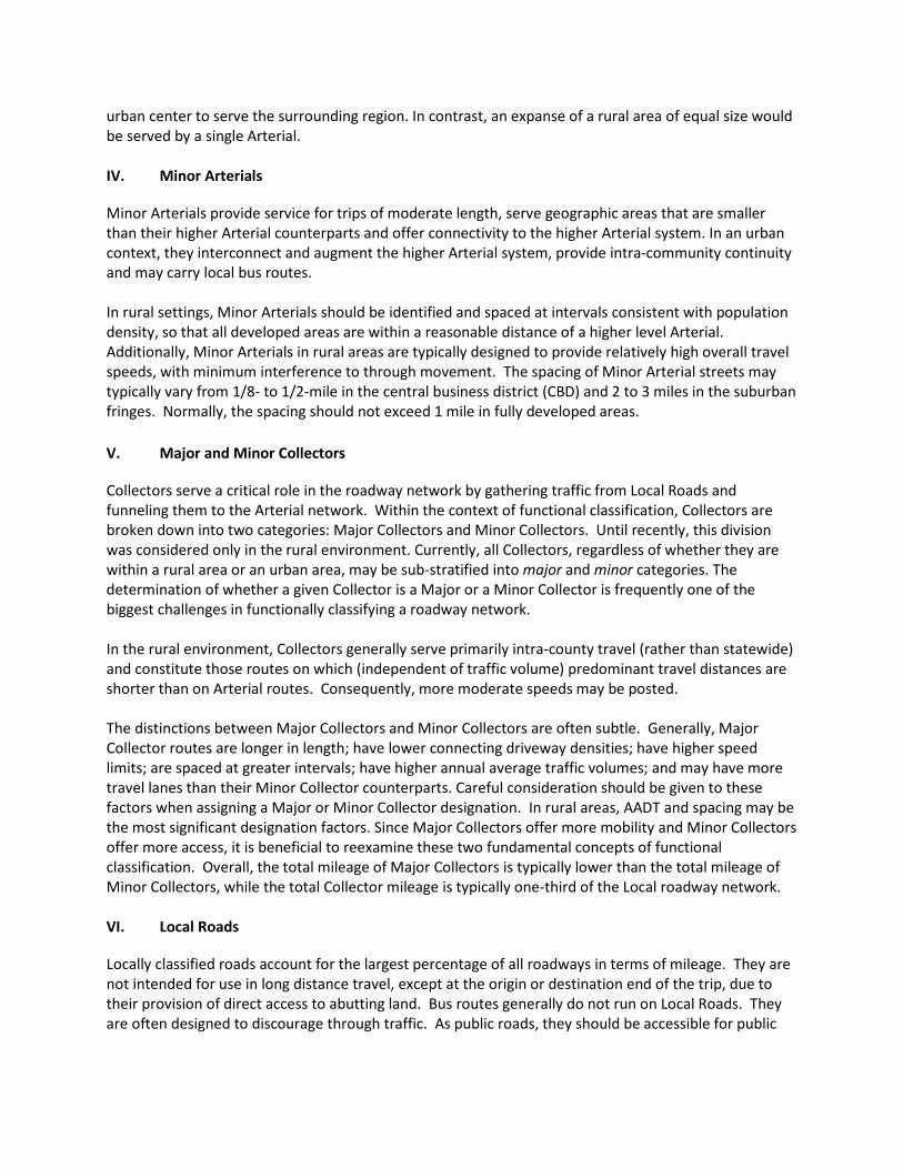
Collectors serve a critical role in the roadway network by gathering traffic from Local Roads and funneling them to the Arterial network. Within the context of functional classification, Collectors are broken down into two categories: Major Collectors and Minor Collectors. Until recently, this division was considered only in the rural environment. Currently, all Collectors, regardless of whether they are within a rural area or an urban area, may be sub-stratified into major and minor categories. The determination of whether a given Collector is a Major or a Minor Collector is frequently one of the biggest challenges in functionally classifying a roadway network. In the rural environment, Collectors generally serve primarily intra-county travel (rather than statewide) and constitute those routes on which (independent of traffic volume) predominant travel distances are shorter than on Arterial routes. Consequently, more moderate speeds may be posted. The distinctions between Major Collectors and Minor Collectors are often subtle. Generally, Major Collector routes are longer in length; have lower connecting driveway densities; have higher speed limits; are spaced at greater intervals; have higher annual average traffic volumes; and may have more travel lanes than their Minor Collector counterparts. Careful consideration should be given to these factors when assigning a Major or Minor Collector designation. In rural areas, AADT and spacing may be the most significant designation factors. Since Major Collectors offer more mobility and Minor Collectors offer more access, it is beneficial to reexamine these two fundamental concepts of functional classification. Overall, the total mileage of Major Collectors is typically lower than the total mileage of Minor Collectors, while the total Collector mileage is typically one-third of the Local roadway network. VI. Local Roads
Locally classified roads account for the largest percentage of all roadways in terms of mileage. They are not intended for use in long distance travel, except at the origin or destination end of the trip, due to their provision of direct access to abutting land. Bus routes generally do not run on Local Roads. They are often designed to discourage through traffic. As public roads, they should be accessible for public

use throughout the year. Local Roads are often classified by default. In other words, once all Arterial and Collector roadways have been identified, all remaining roadways are classified as Local Roads. The functional classification is also used to determine federal funding priority and eligibility for Federal-Aid according to the table below.
Highway Functional Classification System & Federal-Aid Eligibility
Rural
Urban
Principal Arterial Interstate Interstate
Other Freeway & Expressway Other Freeway & Expressway Other Principal Arterial Other Principal Arterial
Minor Arterial Minor Arterial Minor Arterial
Collector Major Collector Major Collector Minor Collector Minor Collector
Local Local
= Federal-Aid Eligible
Additional information on highway functional classification is available in the Federal Highway Administration’s Highway Functional Classification Concepts, Criteria, and Procedures, 2013 Edition.
NHS
EXETER
FOSTER
COVENTRY
SCITUATE
GLOCESTER
BURRILLVILLE
HOPKINTON
RICHMOND
WARWICK
SOUTH KINGSTOWN
TIVERTON
WEST GREENWICH
WESTERLY
CRANSTON
CHARLESTOWN
SMITHFIELD
NORTH KINGSTOWN
JOHNSTON
LINCOLN
CUMBERLAND
PROVIDENCE
LITTL
E CO
MPTO
N
NORTH SMITHFIELD
PORT
SMOU
THBR
ISTO
L
MIDDLETOWN
EAST GREENWICH
NEWPO
RT
EAST PROVIDENCE
JAME
STOW
N
WARREN
WOONSOCKET
NARR
AGAN
SETT
BARRINGTON
[
LegendUrban Boundary 2013RuralMunicipal Boundary
State of Rhode Island
0 2.5 51.25 Miles
Transportation Urban Rural Boundary
This map is not the product of a Professional Land Survey. It was created by RI Statewide Planning Program for general reference,informatonal , pl anni ng and gui danc e use, and is not a legal ly authoritatve sour ce as to locaaon of nat ural or man mad e f eat ures. Proper interpretaton of thi s ma p ma y requi re the assi stance of appropriate professional services. RI Statewide Planning Program makes no warranty, express or implied, related to the spatal accur acy, rel iabi lity, comp l et eness, or cur rent ness of thi s ma p.
FHWA Approved September 11, 2013

REGIONAL WORKSHOPSHighway Functional Classification
For municipal planners, public works directors, and municipal engineers
KENT COUNTYTuesday, June 17, 9:00 a.m.East Greenwich Police Station176 1st AvenueEast Greenwich, RI 02818
WASHINGTON COUNTYTuesday, June 24, 9:00 a.m.URI Coastal Institute, Hazard Room218 South Ferry RoadNarragansett, RI 02874
NEWPORT COUNTYWednesday, June 25, 9:30 a.m.Middletown Police Station123 Valley RoadMiddletown, RI 02908
PROVIDENCE METRO &NORTHERN RIWednesday, June 25, 2:00 p.m.RI Dept. of Administration1 Capitol Hill, Conference Room AProvidence, RI 02908
FOR: Coventry, East Greenwich, WarwickWest Greenwich and West Warwick
FOR: Charlestown, Exeter, Hopkinton,Narragansett, New Shoreham, N.Kingstown, Richmond, S. Kingstown and Westerly
FOR: Bristol, Jamestown, Little Compton,Middletown, Newport, Portsmouth and Tiverton
FOR: Barrington, Burrillville, Central Falls,Cranston, Cumberland, East Providence, Foster, Glocester, Johnston, Lincoln, Pawtucket,Providence, N. Providence, N. Smithfield, Scituate, Smithfield, Warren and Woonsocket
RHODE ISLAND DIVISION OF PLANNING | ONE CAPITOL HILL PROVIDENCE RI 02908401-222-7901 | www.planning.ri.gov
For more information visit:
Join the Rhode Island Statewide Planning Program as it provides anoverview, answers questions, and gathers municipal comments about the Rhode Island Highway Functional Classification. Learn more about how the process affects the future of the state’s roadways and funding for transportation.
www.planning.ri.gov/statewideplanning/transportation/highway.php

APPENDIX 2:
Municipal Comments and Responses

APPENDIX 2: Municipal Comments and Responses
Submitted by Request As Proposed Staff Recommendation Map ID Public Comment AADT Staff Notes
City of Newport Thames Street (local) Minor Arterial
Upgrade Thames Street from Farewell Street to Washington Square from a local to a minor arterial as it connects a principal arterial to a minor arterial.
N/AUpgrade road to minor arterial based on connectivity, continuity, and need to parallel Farewell Street, also a minor arterial.
City of Newport Third Street (local) Minor Collector
Upgrade Third Street from Bridge Street to Van Zandt Avenue from a local to a minor arterial as observed high traffic volumes support its connection between two major collectors.
N/AUpgrade to minor collector for continuity and because of high traffic volumes reported by the City of Newport.
City of Newport Bridge Street (local) Minor Collector
Upgrade Bridge Street from Gladys Carr Bolhouse Boulevard to Third Street from a local to a minor arterial as observed high traffic volumes support its connection between two major collectors.
N/AUpgrade to minor collector to connect Third Street to Gladys Carr Bolhouse Boulevard, both major collectors.
City of Newport Bedlow Avenue (local) Minor Collector
Upgrade Bedlow Avenue from Broadway to Malbone from a local to a minor arterial as observed high traffic volumes support its connection between a principal arterial and a proposed minor arterial.
N/A
Upgrade to minor collector to support its connection between Broadway, a principal arterial, and Malbone Avenue, a proposed minor arterial.
City of Newport Morton Avenue (local road) Minor Arterial
Upgrade Morton Avenue from Thames Street to Spring Street from a local to a minor arterial as observed high traffic volumes support its connection between two minor arterials. This would also keep consistency to maintain the on way couplet as minor arterials.
N/AUpgrade to minor arterial because of traffic volumes and to connect Thames Street and Spring Street, both minor arterials.
City of Newport Spring Street (major collector) Minor Arterial
Upgrade Spring Street from Morton Avenue to Narragansett Avenue from a major collector to a minor arterial as observed high traffic volumes support its connection between two minor arterials. This would also keep consistency to maintain the on way couplet as minor arterials.
N/AUpgrade to minor arterial because the of need to parallel Thames Street, a minor arterial.
Page 1 of 9

APPENDIX 2: Municipal Comments and Responses
Submitted by Request As Proposed Staff Recommendation Map ID Public Comment AADT Staff Notes
City of NewportThames Street (minor collector) (currently a minor arterial)
Major Collector
Upgrade Thames Street from Cotton Court to Mill Street from a minor collector to a major collector as it connects a major collector to a minor collector.
N/ADowngrade to major collector (not to minor collector as proposed originally) to maintain connectivity through downtown Newport.
Quonset Development Corporation (in North Kingstown)
Cross Park Avenue (major collector)
Local Should be downgraded to local N/ADowngrade to local. Road is part of a cul‐de‐sac.
Quonset Development Corporation (in North Kingstown)
Bailey Road (major collector) N/A Road no longer exists and can be deleted. N/A Deleted road from database.
Town of SmithfieldTunmore Road (major collector)
Major Collector 243Upgrade entire length from Cedar Swamp Road to Pleasant View Avenue from local to major collector
N/AUpgrade road to major collector. It connects two principal arterials, Cedar Swamp Road and Pleasant View Avenue.
Town of SmithfieldGreenville Avenue (major collector)
Minor ArterialUpgrade Greenville Avenue from Putnam Pike (US 44) to Sanderson Road from major collector to minor arterial
~2500Upgrade road to minor arterial to improve connectivity between Putnam Pike and Sanderson Road, both principal arterials.
Town of Smithfield Whipple Avenue (local)Minor Collector (Cross St ‐ St. Michaels) / Local (Farnum Pike ‐
St. Michaels)397
Downgrade from major collector to minor collector
N/A
Downgrade Whipple Avenue from Fenwood Ave to St. Michaels to minor collector. Downgrade remaining section, between St. Michaels Avenue and Farnum Pike, to local. Upgrade St. Michaels Avenue to minor collector as it is part of a RIPTA bus route.
Town of SmithfieldWolf Hill Road (major collector)
LocalDowngrade Wolf Hill Road from Farnum Pike to Old County Road from major collector to local
N/ADowngrade road segment to local. It appears to serve local traffic.
City of WoonsocketMorton Avenue (minor arterial)
N/A 155Morton runs from Hamlet Avenue to Park Place. Does not run on the south side of Hamlet Ave. That roadway is Manville Rd. ‐ state‐owned.
N/A Correct roadway name in the GIS database.
Page 2 of 9

APPENDIX 2: Municipal Comments and Responses
Submitted by Request As Proposed Staff Recommendation Map ID Public Comment AADT Staff Notes
City of Woonsocket Front Street (major collector) Major Collector 87This should encompass the southerly approach from Court St onto Front St.
N/AComment noted. Front Street, including the approach from Court Street, is a major collector.
City of WoonsocketBlackstone Street (minor collector)
Minor Collector 19Would like both segments of Blackstone St to have the same classification.
N/ASegment of Blackstone St should remain a minor collector. It is narrower and carries lower volumes than other section.
City of WoonsocketBlackstone Street (major collector)
Major Collector 276Would like both segments of Blackstone St to have the same classification.
8,000Comment noted. Segment of Blackstone St. should remain a major collector because of its width and the connectivity it provides.
City of WoonsocketE School Street (major collector)
Minor Arterial 293
This road should remain as a minor arterial as there are only two local roads that connect to it. The roadway is heavily used to access two different neighborhoods.
6,000
Keep as minor arterial based on the connectivity it provides between N. Main Street, a minor arterial, and Social Street, a principal arterial.
City of WoonsocketJohn A Cummings Way (major collector)
Major Collector 326
This roadway should remain as a minor arterial. It is location in the city's downtown area and runs between two principal arterial roadways (Social St and Clinton St).
N/AComment noted. Road should remain a major collector as it doesn't serve major traffic generators.
City of Woonsocket Pond Street (major collector) Major Collector 362
Pond St runs from Social St to Winter St. The segment between Social St and Clinton St is Veterans' Parkway. It's located in the city's downtown area and runs between two principal arterial roadways (Social St and Clinton St).
N/ARoad should remain a major collector as it doesn't serve major traffic generators.
City of Woonsocket Elm Street (minor collector) Minor Collector 71Segment of Elm St from Gaulin Ave westerly is a one way.
2,000Comment noted. Upgrade Locust St. to minor collector to improve connectivity to Cumberland Street, a principal arterial.
City of Woonsocket Arnold Street (major collector) Major Collector 271 Arnold St from High St to Main St is a one way.Comment noted. Classification as a major collector necessary for circulation through downtown Woonsocket.
City of Woonsocket Greene Street (minor arterial) Minor Arterial 102 One way street N/A Comment noted.
City of Woonsocket 2nd Avenue (major collector) Major Collector 12nd Avenue runs from River Street to Mason Street
N/A Comment noted.
Page 3 of 9

APPENDIX 2: Municipal Comments and Responses
Submitted by Request As Proposed Staff Recommendation Map ID Public Comment AADT Staff Notes
City of Woonsocket Mason Street (major collector) Major Collector 146
This should encompass the southerly approach to South Main St and the northerly direction from South Main St onto Mason St. Both small segments are one ways.
N/AComment noted. Both the north and south approaches are classified as major collectors.
City of Woonsocket Highland Corporate Drive N/A n/aNot listed on state spreadsheet but included on proposed reclassification map for upgrade.
N/A Added road to Woonsocket spreadsheet.
City of Woonsocket River Street (major collector) Major Collector 366
The segment shown is actually from Sayles St to South Main St. What is the remaining portion of River St classified as? This roadway should remain as a major collector as it is highly used by trucks to many different businesses in Woonsocket and a solid waste transfer station in North Smithfield.
N/A
Comment noted. The other portion of River St. is classified as a major collector. The segment between Sayles St. and South Main St. is proposed as a major collector to maintain continuity.
City of Woonsocket Sayles Street (local) N/A 369This is actually from Arnold St to River St and is a one way.
N/A Comment noted and map corrected.
City of Woonsocket Knight Street (local) N/A 330This segment of Knight St does not exist in the field. The are was transformed into a park in order to calm the traffic flow.
N/A GIS database corrected to reflect change.
City of Woonsocket Olo St (Local) Local Upgrade to, at a minimum, minor collector. N/AProvides local access only. Not appropriate for upgrade.
City of Woonsocket Shove St/Avenue A (Local) Minor Collector Upgrade to, at a minimum, minor collector. N/AUpgrade to minor collector to provide access to Globe Park Elementary School.
City of Woonsocket Piedmont St/ Mowry St (Local) Local Upgrade to, at a minimum, minor collector. N/AProvides low connectivity through a residential neighborhood. Not appropriate for upgrade.
City of Woonsocket Mt St Charles Ave (Local) Local Upgrade to, at a minimum, minor collector. N/AProvides low connectivity through a residential neighborhood. Not appropriate for upgrade.
City of WoonsocketOlive St/ Larch St/ Talcott St (Local)
Local Upgrade to, at a minimum, minor collector. N/AProvides low connectivity through a residential neighborhood. Not appropriate for upgrade.
City of WoonsocketNursery Ave/ Campeau St/ Lefrancoise Blvd (Local)
Minor Collector Upgrade to, at a minimum, minor collector. N/AUpgrade Campeau Street to minor collector to improve connectivity with Elder Ballou Meeting House Road, a major collector.
Page 4 of 9

APPENDIX 2: Municipal Comments and Responses
Submitted by Request As Proposed Staff Recommendation Map ID Public Comment AADT Staff Notes
City of Woonsocket Mill St (Local) Local Upgrade to, at a minimum, minor collector. N/AParallels Diamond Hill Road, a minor arterial. Not appropriate for upgrade.
City of Woonsocket Locust St (Local) Minor Collector Upgrade to, at a minimum, minor collector. N/AUpgrade to minor collector to improve connectivity to Cumberland Street, a principal arterial.
City of Woonsocket West School St (Local) Minor Collector Upgrade to, at a minimum, minor collector. N/AUpgrade to minor collector to connect N. Main Street, a minor arterial, and Blackstone Street, a major collector.
City of Woonsocket Arnold St (Local) Local Upgrade to, at a minimum, minor collector. N/AAppears to serve local traffic between Railroad Street and High School Street. Not appropriate for upgrade.
City of Woonsocket Fairmount St (Local) Local Upgrade to, at a minimum, minor collector. N/AThe road is a dead end, not appropriate for upgrade.
City of Woonsocket Mason St (Local) Local Upgrade to, at a minimum, minor collector. N/AAccess road for apartment complex, not appropriate for upgrade to a collector
City of Woonsocket Bourdon Blvd (Local) Local Upgrade to, at a minimum, minor collector. N/AAccess road for apartment complex, not appropriate for upgrade to a collector
City of Woonsocket Asylum St (Local) Local Upgrade to, at a minimum, minor collector. N/AAccess road for apartment complex and is a dead end, not appropriate for upgrade to a collector.
City of Woonsocket Olo St (Local) Local Upgrade to, at a minimum, minor collector. N/AThe road is a dead end, not appropriate for upgrade.
City of Woonsocket Broad St (Local) Local Upgrade to, at a minimum, minor collector. N/ARoad parallels Ballou Street. Not appropriate for upgrade.
City of Woonsocket Lydia Ave (Local) Local Upgrade to, at a minimum, minor collector. N/AThe road is a dead end, not appropriate for upgrade.
City of Woonsocket Grove St (Local) Local Upgrade to, at a minimum, minor collector. N/ARoad parallels Park Avenue, a principal arterial. Not appropriate for upgrade.
City of Woonsocket Carrington Ave (Local) Local 284 Upgrade to, at a minimum, minor collector. N/ADowngrade to local due to parallel route with Hamlet Avenue, a principal arterial.
City of Woonsocket Willow St (Local) Local 399 Upgrade to, at a minimum, minor collector. N/ADowngrade to local due to parallel route with Hamlet Avenue, a principal arterial.
Page 5 of 9

APPENDIX 2: Municipal Comments and Responses
Submitted by Request As Proposed Staff Recommendation Map ID Public Comment AADT Staff Notes
City of Woonsocket CVS Drive (Local) Local Upgrade to, at a minimum, minor collector. N/AThe road is a dead end, not appropriate for upgrade.
City of Woonsocket Century Drive (Local) Local Upgrade to, at a minimum, minor collector. N/AThe road is a dead end, not appropriate for upgrade.
City of Woonsocket Goldstein Ave (Local) Local Upgrade to, at a minimum, minor collector. N/AThe road is a dead end, not appropriate for upgrade.
City of Woonsocket Bound Rd (Local) Local Upgrade to, at a minimum, minor collector. N/AThe road is a dead end, not appropriate for upgrade.
City of Woonsocket Grandview Ave (Local) Local Upgrade to, at a minimum, minor collector. N/ARoad serves local traffic through a residential neighborhood. Not appropriate for upgrade.
City of Woonsocket Halsey Rd (Local) Local Upgrade to, at a minimum, minor collector. N/ARoad serves local traffic through a residential neighborhood. Not appropriate for upgrade.
City of WoonsocketWalnut Hill Rd/ Surrey Ln (Local)
Local Upgrade to, at a minimum, minor collector. N/ARoad serves local traffic through a residential neighborhood. Not appropriate for upgrade.
City of Woonsocket Knollwood Drive (Local) Local Upgrade to, at a minimum, minor collector. N/ARoad serves local traffic through a residential neighborhood. Not appropriate for upgrade.
City of Woonsocket Diamond Hill Rd (Local) Local Upgrade to, at a minimum, minor collector. 600This section of the road has a low AADT and provides low connectivity. Not appropriate for upgrade.
City of Woonsocket Linden Ave (Local) Local Upgrade to, at a minimum, minor collector. N/ANot appropriate for upgrade. Provides limited connectivity through a residential neighborhood.
City of Woonsocket Morin Heights Blvd (Local) Local Upgrade to, at a minimum, minor collector. N/ANot appropriate for upgrade. Provides limited connectivity through a residential neighborhood.
City of Woonsocket Robinson St (Local) Local Upgrade to, at a minimum, minor collector. N/AParallels Elm Street, a minor collector. Not appropriate for upgrade.
City of Woonsocket Federal St (Local) Local Upgrade to, at a minimum, minor collector. N/ARoad serves local traffic and parallels Clinton Street, a principal arterial. Not appropriate for upgrade.
City of Woonsocket Rhodes Ave (Major Collector) Major Collector Upgrade to, at a minimum, minor collector. N/A Road is already a major collector.
City of Woonsocket2nd Ave (Major Collector, Local)
Major Collector Upgrade to, at a minimum, minor collector. N/ARoad already upgraded to major collector. Serves as a north‐south connector.
Page 6 of 9

APPENDIX 2: Municipal Comments and Responses
Submitted by Request As Proposed Staff Recommendation Map ID Public Comment AADT Staff Notes
City of Woonsocket Fairmount St (Major Collector) Major Collector Upgrade to, at a minimum, minor collector. N/A Road remains a major collector.
City of Woonsocket Mason St (Major Collector) Major Collector Upgrade to, at a minimum, minor collector. N/A Road remains a major collector.
City of Woonsocket S Main St (Minor Arterial) Minor Arterial Upgrade to, at a minimum, minor collector. N/A Road remains a minor arterial.
City of Woonsocket Ballou St (Major Collector) Major Collector Upgrade to, at a minimum, minor collector. N/A Road remains a major collector.
City of Woonsocket Providence St (Minor Arterial) Minor Arterial Upgrade to, at a minimum, minor collector. N/A Road remains a minor arterial.
City of Woonsocket Transit St (Major Collector) Major Collector Upgrade to, at a minimum, minor collector. N/A Road remains a major collector.
City of Woonsocket Carnation St (Major Collector) Major Collector Upgrade to, at a minimum, minor collector. N/A Road remains a major collector.
City of WoonsocketKnight St/Cottage St (Major Collector)
Major Collector Upgrade to, at a minimum, minor collector. N/A Road remains a major collector.
City of WoonsocketLogee St/Bertenshaw Rd (Major Collector)
Major Collector Upgrade to, at a minimum, minor collector. 4,200 Road remains a major collector.
City of Woonsocket Park Ave (Principal Arterial) Principal Arterial Upgrade to, at a minimum, minor collector. 14,000 Road remains a principal arterial.
City of Woonsocket Front St (Major Collector) Major Collector Upgrade to, at a minimum, minor collector. 6,000 Road remains a major collector.
City of Woonsocket Bernon St (Minor Arterial) Minor Arterial Upgrade to, at a minimum, minor collector. 8,000 Road remains a minor arterial.
City of Woonsocket Greene St (Minor Arterial) Minor Arterial Upgrade to, at a minimum, minor collector. N/A Road remains a minor arterial.
City of Woonsocket Manville Rd (Minor Arterial) Minor Arterial Upgrade to, at a minimum, minor collector. 7,700 Road remains a minor arterial.
City of Woonsocket Hamlet Ave (Principal Arterial) Principal Arterial Upgrade to, at a minimum, minor collector. 16,200 Road remains a principal arterial.
City of Woonsocket Route 99 (Other Freeway) Other Freeway Upgrade to, at a minimum, minor collector. N/ARoad remains an other freeway or expressway.
City of WoonsocketCumberland St/ Cumberland Hill Rd/ Mendon Rd (Principal Arterial)
Principal Arterial Upgrade to, at a minimum, minor collector. 16,650 Road remains a principal arterial.
City of Woonsocket Bound Rd (Major Collector) Major Collector Upgrade to, at a minimum, minor collector. N/A Road remains a major collector.
City of Woonsocket Cass Ave (Minor Arterial) Minor Arterial Upgrade to, at a minimum, minor collector. 76,300 Road remains a minor arterial.
Page 7 of 9

APPENDIX 2: Municipal Comments and Responses
Submitted by Request As Proposed Staff Recommendation Map ID Public Comment AADT Staff Notes
City of Woonsocket Elm St (Minor Collector) Minor Collector 71 Upgrade to, at a minimum, minor collector. 2,000Proposed for downgrade to minor collector. It parallels Cass Avenue (minor arterial) and Cumberland Street (principal arterial).
City of WoonsocketMendon Rd (Some Portions Minor Arterial, Principal Arterial)
Minor Arterial/Principal Arterial
Upgrade to, at a minimum, minor collector. N/ARoad remains principal arterial and minor arterial.
City of WoonsocketDiamond Hill Rd (Some portions Minor Arterial, Principal Arterial )
Minor Arterial/Principal Arterial
Upgrade to, at a minimum, minor collector. 14,600Road remains principal arterial and minor arterial.
City of Woonsocket Wood Ave (Major Collector) Major Collector 402 Upgrade to, at a minimum, minor collector. N/AProposed for downgrade to major collector. It connects Diamond Hill Road, a principal arterial, and Cass Avenue, a minor arterial.
City of WoonsocketWinthrop St/ St Leon Ave (Minor Collector)
Minor Collector367/ 401
Upgrade to, at a minimum, minor collector. N/A
Proposed for downgrade to minor collector. Provides a connection through a neighborhood to Diamond Hill Road, a principal arterial.
City of Woonsocket Clinton St (Principal Arterial) Principal Arterial Upgrade to, at a minimum, minor collector. N/A Road remains a principal arterial.
City of Woonsocket Social St (Principal Arterial) Principal Arterial Upgrade to, at a minimum, minor collector. 14,100 Road remains a principal arterial.
City of Woonsocket Truman Dr (Minor Arterial) Minor Arterial Upgrade to, at a minimum, minor collector. N/A Road remains a minor arterial.
City of Woonsocket Court St/Sq (Principal Arterial) Principal Arterial Upgrade to, at a minimum, minor collector. 18,000 Road remains a principal arterial.
City of WoonsocketMain St (Some portions Principal Arterial, Minor Arterial)
Minor Arterial/Principal Arterial
Upgrade to, at a minimum, minor collector. N/APortions of road remain principal arterial and minor arterial.
City of WoonsocketJohn A Cummings Way (Major Collector)
Major Collector 326 Upgrade to, at a minimum, minor collector. N/AProposed for downgrade to major collector. It doesn't serve major traffic generators.
City of Woonsocket Rathburn St (Minor Arterial) Minor Arterial Upgrade to, at a minimum, minor collector. N/A Road remains a minor arterial.
City of Woonsocket Privilege St (Minor Arterial) Minor Arterial Upgrade to, at a minimum, minor collector. 5,600 Road remains a minor arterial.
City of Woonsocket Pond St (Major Collector) Major Collector 362 Upgrade to, at a minimum, minor collector. N/AProposed for downgrade to major collector. It doesn't serve major traffic generators.
City of Woonsocket Winter St (Minor Arterial) Minor Arterial Upgrade to, at a minimum, minor collector. 5,600 Road remains a minor arterial.
Page 8 of 9

APPENDIX 2: Municipal Comments and Responses
Submitted by Request As Proposed Staff Recommendation Map ID Public Comment AADT Staff Notes
City of Woonsocket N Main St (Minor Arterial) Minor Arterial Upgrade to, at a minimum, minor collector. 14,900 Road remains a minor arterial.
City of WoonsocketRiver St (Minor Arterial/Major Collector)
Major Collector 366 Upgrade to, at a minimum, minor collector. 6,000Proposed for downgrade to a major collector. It parallels Harris Avenue, a minor arterial.
City of Woonsocket Blackstone St (Minor Collector) Minor Collector 19 Upgrade to, at a minimum, minor collector. N/AProposed for upgrade to minor collector. It serves as an east‐west connector.
City of Woonsocket Blackstone St (Major Collector) Major Collector 276 Upgrade to, at a minimum, minor collector. 8,000Proposed for downgrade to major collector. It parallels Winter Street, a minor arterial.
City of Woonsocket Harris Ave (Minor Arterial) Minor Arterial Upgrade to, at a minimum, minor collector. 9,000 Road remains a minor arterial.
City of Woonsocket Railroad St (Minor Arterial) Minor Arterial Upgrade to, at a minimum, minor collector. 4,000 Road remains a minor arterial.
City of Woonsocket High St (Major Collector) Major Collector Upgrade to, at a minimum, minor collector. 8,000 Road remains a major collector.
City of Woonsocket Arnold St (Major Collector) Major Collector 271 Upgrade to, at a minimum, minor collector. N/AProposed for downgrade to major collector. Road width and function do not justify a higher classification.
Page 9 of 9

APPENDIX 3:
Transportation Advisory CommitteeComments and Responses

APPENDIX 3
Transportation Advisory Committee Comments and Responses
Summary of comments made by members of the Transportation Advisory Committee at its June 26, 2014 meeting and responses from the Statewide Planning Program and the Rhode Island Department of Transportation.
Comment 1Does the Green Book govern roadway design on all projects eligible for federal funding?
Comment 2Do municipalities have to follow the Green Book for the design of projects that are not federally funded?
ResponseThe term “Green Book” refers to the document, A Policy on Geometric Design of Highways and Streets, published by the American Association of State Highway and Transportation Officials (AASHTO); the latest version was released in 2011. The Green Book contains a set of recommendations for safe and efficient roadway design, which are based on extensive research and study; they provide a range of acceptable design criteria based on the type of roadway and the expected amount of traffic the roadway will carry.
FHWA has adopted the 2001 Green Book as the minimum standard for all roadway projects on the National Highway System regardless of funding source (ref: 23 CFR 625.3). The National Highway System (NHS) is the system of roads deemed most important to the economy, defense, and mobility of the nation; it includes all roadways classified as interstates, other freeways and expressways, or other principal arterials. Exceptions to the Green Book standards for NHS roadways may be made when approved by the FHWA Division Administrator and when conditions warrant that exceptions be made, for example when the work is “very minor,” after consideration of cost-benefits, and for compatibility with adjacent sections of roadway.
Projects on roadways that use federal funds but are not on the National Highway System must also follow Green Book design standards, because the State of Rhode Island has adopted them as its minimum roadway design standards. Again exceptions may be made where conditions warrant.
Roadway projects that do not use federal funds and are not on the National Highway System must follow the design standards adopted by the local municipality, which may be contained in a city or town’s zoning, planning, or engineering regulations. In many cases Rhode Island municipalities have also adopted the Green Book standards for safe and efficient practices for the design of roadways.
Comment 3What is the impact of a change in a roadway’s functional classification on its design?
ResponseThe FHWA’s Highway Functional Classification Concepts, Criteria and Procedures, 2013 Edition states that, “functional classification does not dictate design.” Instead functional classification defines and describes the role a roadway plays in the nation’s highway network based on its current use and function. Highway functional classification is not a plan for the future or a prescription for future roadway design changes. A roadway’s functional classification may be considered when considering improvements, but it is just one of many elements considered in the planning and design process, including travel speed, safety, environmental concerns, livability, costs and benefits, traffic volumes, and others. The primary uses of the functional classification system are for determining federal funding eligibility and tracking roadway system performance and condition.

APPENDIX 4:
Highway Functional ClassificationChanges

APPENDIX 4: Highway Functional Classification ChangesUPGRADES
Roadway Name MunicipalityCurrent Functional
ClassificationProposed Functional
ClassificationLimits Miles Map ID
2012 AADT
Urban / Rural
Current Federal Aid Eligible
Proposed Federal Aid Eligible
Currently on NHS
Proposed NHS
Upgrade ‐ Other Principal Arterial to Other Freeway & Expressway 14.62Rt. 1 (Post Rd and Commodore Perry Hwy)
CHARLESTOWN, SOUTH KINGSTOWN
Other Principal ArterialOther Freeway &
ExpresswayWildflower Rd to Post Rd in South Kingstown 10.73 416, 417 17,600 Rural Yes Yes Yes Yes
STATE HWY 37 E CRANSTON Other Principal ArterialOther Freeway &
ExpresswayNatick Ave to I‐295 S 0.31 233 17,700 Urban Yes Yes Yes Yes
State Hwy 138 (Newport Pell Bridge Deck and Approaches)
JAMESTOWN, NEWPORT
Other Principal ArterialOther Freeway &
Expressway
Service Rd (just Northwest of Pell Bridge Toll Plaza in Jamestown) to Pell Bridge Deck Area to Rt. 138 off‐ramp at Newport Grand at Admiral Kalbfus Rd
3.58 232 26,800 Urban Yes Yes Yes Yes
Upgrade ‐ Minor Arterial to Other Principal Arterial 52.78
Rt. 2 (S COUNTY TRL)CHARLESTOWN, SOUTH
KINGSTOWN, RICHMOND
Minor Arterial Other Principal Arterial Kingstown Rd (Rt. 138) to Post Rd (Rt. 1) 9.65 217 7,100 Rural Yes Yes No Yes
Rt. 44 (PUTNAM PIKE) GLOCESTER Minor Arterial Other Principal Arterial Rt. 102 to CT Line 6.82 194 1,900 Rural Yes Yes No Yes
Rt. 116 (EAST RD & W GREENVILLE SCITUATE Minor Arterial Other Principal Arterial Scituate Ave to Danielson Pike 5.36 210 4,300 Rural Yes Yes No Yes
Rt. 102 (VICTORY HWY & TEN ROD RD)
WEST GREENWICH, EXETER, NORTH KINGSTOWN
Minor Arterial Other Principal ArterialI‐95N to Nooseneck Hill Rd (Rt. 3), and Nooseneck Hill Rd to Rt 2. (South County Trail) ‐ note roadway is briefly segmented by Nooseneck Hill Rd (Rt. 3)
8.41 209 8,600 Rural Yes Yes No Yes
Rt. 33 (SANDY BOTTOM RD & WOOD ST)
COVENTRY Minor Arterial Other Principal Arterial Main St to Wood St 0.53 212 N/A Urban Yes Yes No Yes
Rt. 401 (DIVISION ST & 1ST AVE) EAST GREENWICH Minor Arterial Other Principal Arterial Quaker Lane/S County Trail to Main St 2.86 213 13,900 Urban Yes Yes No Yes
Rt. 138A (AQUIDNECK AVE) MIDDLETOWN Minor Arterial Other Principal Arterial East Main Rd (Rt. 138) to Valley Rd (Rt. 214) 2.01 57,100 to 15,300
Urban Yes Yes No Yes
GALILEE CONNECTOR RD NARRAGANSETT Minor Arterial Other Principal Arterial Great Island Rd to Sand Hill Cove Rd 0.37 89 1,400 Urban Yes Yes No Yes
GALILEE ESCAPE RD NARRAGANSETT Minor Arterial Other Principal Arterial Great Island Rd to Point Judith Rd (Rt. 108) 1.12 91 2,400 Urban Yes Yes No Yes
GREAT ISLAND RD NARRAGANSETT Minor Arterial Other Principal Arterial Galilee Escape Rd to Sand Hill Cove Rd 0.30 100 1800* Urban Yes Yes No Yes
SAND HILL COVE RD NARRAGANSETT Minor Arterial Other Principal Arterial Great Island Rd to Galilee Connector Rd 0.16 219 1900* Urban Yes Yes No Yes
MARLBOROUGH ST NEWPORT Minor Arterial Other Principal Arterial Farewell St to Broadway 0.09 143 N/A Urban Yes Yes No Yes
DAVISVILLE RD NORTH KINGSTOWN Minor Arterial Other Principal Arterial Rt. 403 to road terminus at pier 2.59 56 2,700 Urban Yes Yes No Yes
ROGER WILLIAMS WAY NORTH KINGSTOWN Minor Arterial Other Principal Arterial Commerce Park Rd to road terminus at pier 1.20 204 10,600 Urban Yes Yes No Yes
Rt. 114 (EXCHANGE ST) PAWTUCKET Minor Arterial Other Principal Arterial Broad St to Broadway 0.39 74 14300* Urban Yes Yes No Yes
Rt. 15/Rt. 1 (GOFF AVE) PAWTUCKET Minor Arterial Other Principal Arterial Dexter St to Broad St 0.09 97 N/A Urban Yes Yes No Yes
ROOSEVELT AVE PAWTUCKET Minor Arterial Other Principal Arterial Exchange St to Main St 0.22 206 N/A Urban Yes Yes No Yes
Rt. 138 (E MAIN RD) PORTSMOUTH Minor Arterial Other Principal Arterial Boyds Ln to Turnpike Ave 1.87 63 10,100 Urban Yes Yes No Yes
Rt. 1A (EDDY ST) PROVIDENCE Minor Arterial Other Principal Arterial Allens Ave to Thurbers Ave 1.04 69 17,100 Urban Yes Yes No Yes
GANO ST PROVIDENCE Minor Arterial Other Principal Arterial Angell St to I‐195W On‐ramp 0.76 92 19,400 Urban Yes Yes No Yes
Page 1 of 8

APPENDIX 4: Highway Functional Classification ChangesUPGRADES
Roadway Name MunicipalityCurrent Functional
ClassificationProposed Functional
ClassificationLimits Miles Map ID
2012 AADT
Urban / Rural
Current Federal Aid Eligible
Proposed Federal Aid Eligible
Currently on NHS
Proposed NHS
POINT ST PROVIDENCE Minor Arterial Other Principal Arterial Service Road 7 to Eddy St. 0.40 186 25,000 Urban Yes Yes No Yes
THURBERS AVE PROVIDENCE Minor Arterial Other Principal Arterial 0.28 240 N/A Urban Yes Yes No Yes
Rt. 116 (PLEASANT VIEW AVE) SMITHFIELD Minor Arterial Other Principal Arterial Putnam Pike (Rt. 44) to Cedar Swamp Rd (Rt. 5) 0.94 185 6,200 Urban Yes Yes No Yes
TWIN RIVER RD SMITHFIELD, LINCOLN Minor Arterial Other Principal ArterialDouglas Pike to RI‐146 on‐ramp on the east side of RI‐146
2.14 246 9,800 Urban Yes Yes No Yes
BRIDGETOWN RDSOUTH KINGSTOWN, NARRAGANSETT
Minor Arterial Other Principal Arterial Tower Hill Rd to Boston Neck Rd 1.99 26 10,119 Urban Yes Yes No Yes
Rt. 103 (CHILD ST & WILBUR AVE) WARREN Minor Arterial Other Principal Arterial Metacom Ave to Long Ln 1.19 43 14,900 Urban Yes Yes No Yes
NASHUA ST/SMITHFIELD AVE PROVIDENCE Minor Arterial Other Principal Arterial Rebuilt segment from Concord St to N Main St 0.01 161 N/A Urban Yes Yes No Yes
Upgrade ‐ Major Collector to Other Principal Arterial 0.44
Rt. 7 (DOUGLAS TURNPIKE) BURRILLVILLE Major Collector Other Principal Arterial Victory Highway to Rt. 102 0.29 61 N/A Urban Yes Yes No Yes
WILLETT AVE EAST PROVIDENCE Major Collector Other Principal Arterial Turner Ave to Dorr Ave 0.02 262 25,200 Urban Yes Yes No Yes
SMITH ST NORTH PROVIDENCE Major Collector Other Principal Arterial Allen Ave to Dewey Ave 0.01 226 12700 Urban Yes Yes No Yes
NOOSENECK HILL RD WEST GREENWICH Major Collector Other Principal Arterial I‐95 N to Division Rd 0.12 166 5700 Urban Yes Yes No Yes
Upgrade ‐ Minor Collector to Other Principal Arterial 8.00
Rt. 138 (Nooseneck Hill Rd, Spring St, Main St, Kingstown Rd)
RICHMOND, HOPKINTON, EXETER
Minor Collector Other Principal Arterial CT Border to I‐95 at Exit 3B 8.00 2111,900 to 8,200
Rural No Yes No Yes
Upgrade ‐ Local to Other Principal Arterial 0.38
W GREENVILLE RDGLOCESTER/ SMITHFIELD
Local Other Principal Arterial Ramp from W Greenville Rd to Smith Ave 0.07 413 N/A Urban No Yes No Yes
MARLBOROUGH ST NEWPORT Local Other Principal Arterial Thames St to Farewell St 0.09 144 N/A Urban No Yes No Yes
W MARLBOROUGH ST NEWPORT Local Other Principal Arterial America's Cup Ave to Thames St 0.10 253 N/A Urban No Yes No Yes
S MAIN ST PROVIDENCE Local Other Principal Arterial I‐195 W off‐ramp to I‐195‐E on‐ramp 0.12 218 N/A Urban No Yes No Yes
Upgrade ‐ Major Collector to Minor Arterial 42.42HARRISON AVE NEWPORT Major Collector Minor Arterial Fort Adams Dr to Halidon Ave 0.40 106 5,000 Both Yes Yes No NoFLAT RIVER RD COVENTRY Major Collector Minor Arterial Plainfield Pike to Victory Hwy 4.51 78 2,700 Rural Yes Yes No NoALTON BRADFORD RD HOPKINTON Major Collector Minor Arterial Ashaway Rd to Westerly border 0.31 2 N/A Rural Yes Yes No NoCRANDALL RD LITTLE COMPTON Major Collector Minor Arterial Tiverton border to Main St 0.62 53 N/A Rural Yes Yes No NoMAIN ST LITTLE COMPTON Major Collector Minor Arterial Stone Church Rd to Crandall Rd 0.10 139 N/A Rural Yes Yes No NoSTONE CHURCH RD LITTLE COMPTON Major Collector Minor Arterial Tiverton border to Main St 0.63 235 900 Rural Yes Yes No No
W MAIN RD LITTLE COMPTON Major Collector Minor ArterialTiverton border just short of Anthony Way to Meetinghouse Ln
3.12 252 4,600 Rural Yes Yes No No
BEACH AVE NEW SHOREHAM Major Collector Minor Arterial Center Rd to Ocean Rd 0.37 11 1,100 Rural Yes Yes No No
CENTER RD NEW SHOREHAM Major Collector Minor ArterialBeach Ave to Airport entrance 0.2mi past Beacon Hill Rd
0.32 39 1,500 Rural Yes Yes No No
FEDERAL RD BARRINGTON Major Collector Minor ArterialMiddle Hwy to Massasoit Ave Bridge midpoint near the white church
0.73 77 N/A Urban Yes Yes No No
NEW MEADOW RD BARRINGTON Major Collector Minor Arterial Massasoit Ave to County Rd 1.26 165 4,200 Urban Yes Yes No NoBAYVIEW AVE BRISTOL Major Collector Minor Arterial High St to Metacom Ave 0.84 10 5,300 Urban Yes Yes No NoTUPELO ST BRISTOL Major Collector Minor Arterial Hope St to Metacom Ave 0.74 244 4,100 Urban Yes Yes No No
Page 2 of 8

APPENDIX 4: Highway Functional Classification ChangesUPGRADES
Roadway Name MunicipalityCurrent Functional
ClassificationProposed Functional
ClassificationLimits Miles Map ID
2012 AADT
Urban / Rural
Current Federal Aid Eligible
Proposed Federal Aid Eligible
Currently on NHS
Proposed NHS
MAIN STCOVENTRY/
CRANSTON/ WEST WARWICK
Major Collector Minor Arterial Jackson Flat Rd to Fairview Ave 1.08 137 N/A Urban Yes Yes No No
NATICK AVE CRANSTON Major Collector Minor Arterial Phenix Ave to Conley Ave 0.53 162 N/A Urban Yes Yes No NoPHENIX AVE CRANSTON Major Collector Minor Arterial Scituate Ave to Olney Arnold Rd 2.16 181 7,900 Urban Yes Yes No NoWILBUR AVE CRANSTON Major Collector Minor Arterial Natick Ave to Oaklawn Ave 0.55 260 11,500 Urban Yes Yes No NoJACKSON FLAT RD CRANSTON/ SCITUATE Major Collector Minor Arterial Hope View Ave to Main St 0.53 122 N/A Urban Yes Yes No NoANN AND HOPE WAY CUMBERLAND Major Collector Minor Arterial Mendon Rd to Broad St 0.28 3 N/A Urban Yes Yes No NoMIDDLE RD EAST GREENWICH Major Collector Minor Arterial S County Trail to Avenger Dr 0.41 149 5,100 Urban Yes Yes No NoCENTRE ST EAST PROVIDENCE Major Collector Minor Arterial N Broadway to Pawtucket Ave 0.54 41 N/A Urban Yes Yes No NoFORBES ST EAST PROVIDENCE Major Collector Minor Arterial Willet Ave to Wampanoag Trl 1.51 80 3,600 Urban Yes Yes No NoWAMPANOAG TRL EAST PROVIDENCE Major Collector Minor Arterial Pawtucket Ave to E Shore Expwy N 1.05 254 8,830 Urban Yes Yes No NoGREEN END AVE MIDDLETOWN Major Collector Minor Arterial Valley Rd to Indian Ave 2.60 101 N/A Urban Yes Yes No NoPARADISE AVE MIDDLETOWN Major Collector Minor Arterial Purgatory Rd to Hanging Rock Rd 0.11 174 N/A Urban Yes Yes No NoPURGATORY RD MIDDLETOWN Major Collector Minor Arterial Aquidneck Ave to Paradise Ave 0.83 193 3,700 Urban Yes Yes No NoOLD BOSTON NECK RD NARRAGANSETT Major Collector Minor Arterial Middlebridge Rd to Boston Neck Rd 0.39 169 N/A Urban Yes Yes No No
MIDDLEBRIDGE RDNARRAGANSETT/
SOUTH KINGSTOWNMajor Collector Minor Arterial Tory Rd to Old Boston Neck Rd 0.43 152 7,800 Urban Yes Yes No No
BELLEVUE AVE NEWPORT Major Collector Minor Arterial Narragansett Ave to Coggleshall Ave 1.59 14 N/A Urban Yes Yes No NoCARROLL AVE NEWPORT Major Collector Minor Arterial Morton Ave to Harrison Ave 0.14 32 N/A Urban Yes Yes No NoCOGGESHALL AVE NEWPORT Major Collector Minor Arterial Ocean Ave to Bellevue Ave 0.04 46 N/A Urban Yes Yes No NoHALIDON AVE NEWPORT Major Collector Minor Arterial Wickham Rd to Wellington Ave 0.35 104 N/A Urban Yes Yes No NoMALBONE RD NEWPORT Major Collector Minor Arterial Admiral Kalbfus Rd to Broadway 0.71 142 3,400 Urban Yes Yes No NoRUGGLES AVE NEWPORT Major Collector Minor Arterial Harrison Ave to Halidon Ave 0.30 214 5,126 Urban Yes Yes No NoSPRING ST NEWPORT Major Collector Minor Arterial Narragansett Ave to Morton Ave 0.15 295 N/A Urban Yes Yes No NoTHAMES ST NEWPORT Major Collector Minor Arterial Narragansett Ave to Morton Ave 0.15 239 N/A Urban Yes Yes No NoWELLINGTON AVE NEWPORT Major Collector Minor Arterial Haldon Ave to Thames St 0.70 258 N/A Urban Yes Yes No NoMAIN ST NORTH SMITHFIELD Major Collector Minor Arterial N Main St to Railroad St 0.07 140 3,000 Urban Yes Yes No NoBEVERAGE HILL RD PAWTUCKET Major Collector Minor Arterial Pawtucket Ave to Newport Ave 0.71 15 N/A Urban Yes Yes No NoCOMSTOCK ST PAWTUCKET Major Collector Minor Arterial Lonsdale Ave to Main St 0.18 50 N/A Urban Yes Yes No NoPEARL ST PAWTUCKET Major Collector Minor Arterial Main St to Marin St 0.20 177 N/A Urban Yes Yes No NoSUMMIT ST PAWTUCKET Major Collector Minor Arterial Walcott St to Division St 0.23 237 N/A Urban Yes Yes No NoWEEDEN ST PAWTUCKET Major Collector Minor Arterial Power Rd to Smithfield Ave 0.12 257 N/A Urban Yes Yes No NoBARTON ST PROVIDENCE Major Collector Minor Arterial Broadway to Westminster 0.15 9 N/A Urban Yes Yes No NoBLACKSTONE BLVD PROVIDENCE Major Collector Minor Arterial Hope St to Butler Ave 1.68 17 12,000 Urban Yes Yes No NoBUTLER AVE PROVIDENCE Major Collector Minor Arterial Blackstone Blvd to Waterman St 0.40 29 N/A Urban Yes Yes No NoDUXBURY ST PROVIDENCE Major Collector Minor Arterial Killingly St to Plainfield St 0.12 62 N/A Urban Yes Yes No NoEAGLE ST PROVIDENCE Major Collector Minor Arterial Valley St to Killingly Ave 0.09 65 N/A Urban Yes Yes No NoFRANCIS ST PROVIDENCE Major Collector Minor Arterial Smith St to Exchange Terr 0.57 82 8,700 Urban Yes Yes No NoFRIENDSHIP ST PROVIDENCE Major Collector Minor Arterial Plain St to Point St 0.16 84 N/A Urban Yes Yes No NoGASPEE ST PROVIDENCE Major Collector Minor Arterial Smith St to Francis St 0.25 94 7,700 Urban Yes Yes No NoKINSLEY AVE PROVIDENCE Major Collector Minor Arterial Dean St to Park St 0.48 126 8,800 Urban Yes Yes No NoPARK ST PROVIDENCE Major Collector Minor Arterial Hays St to Kinsley Ave 0.12 176 13,300 Urban Yes Yes No NoPINE ST PROVIDENCE Major Collector Minor Arterial Plain St to Lockwood St 0.20 183 N/A Urban Yes Yes No NoPROMENADE ST PROVIDENCE Major Collector Minor Arterial Dean St to Park St 0.49 191 N/A Urban Yes Yes No NoMAIN ST SCITUATE Major Collector Minor Arterial Jackson Flat Rd to North Rd 0.28 138 N/A Urban Yes Yes No No
GREENVILLE AVESMITHFIELD/ JOHNSTON
Major Collector Minor Arterial Putnam Pike to Sanderson Rd 1.41 422 N/A Urban Yes Yes No No
TORRY RD SOUTH KINGSTOWN Major Collector Minor Arterial Tower Hill Rd to Middlebridge Rd 0.55 242 N/A Urban Yes Yes No No
EAST AVEWARWICK/ WEST
WARWICKMajor Collector Minor Arterial River St to Bald Hill Rd 0.32 66 10,500 Urban Yes Yes No No
DIVISION RD WEST GREENWICH Major Collector Minor ArterialNew London Tpk to East Greenwich border, 0.2mi past Carr's Pond Rd
0.43 59 N/A Urban Yes Yes No No
HOPKINS HILL RD WEST GREENWICH Major Collector Minor Arterial I‐95 S to Division Rd 0.26 116 N/A Urban Yes Yes No NoNEW LONDON TPKE WEST GREENWICH Major Collector Minor Arterial I‐95 S to Division Rd 0.53 163 N/A Urban Yes Yes No NoRIVER ST WEST WARWICK Major Collector Minor Arterial Providence St to East Ave 0.27 201 N/A Urban Yes Yes No No
Page 3 of 8

APPENDIX 4: Highway Functional Classification ChangesUPGRADES
Roadway Name MunicipalityCurrent Functional
ClassificationProposed Functional
ClassificationLimits Miles Map ID
2012 AADT
Urban / Rural
Current Federal Aid Eligible
Proposed Federal Aid Eligible
Currently on NHS
Proposed NHS
OAK ST WESTERLY Major Collector Minor Arterial High St to Tower St 0.50 167 7,110 Urban Yes Yes No NoRAILROAD AVE WESTERLY Major Collector Minor Arterial Canal St to Grove Ave 0.33 195 N/A Urban Yes Yes No NoGREENE ST WOONSOCKET Major Collector Minor Arterial Hamlet Ave to Park Ave 0.30 102 N/A Urban Yes Yes No NoUpgrade ‐ Local to Minor Arterial 4.46
ROUTE 117 COVENTRY Local Minor Arterial Ramp from Plainfield Pike to Flat River Rd 0.08 208 N/A Rural No Yes No No
HIGH ST BURRILLVILLE Local Minor Arterial A few yards short of S Main St to Sayelsville Ave 0.02 112 7,500 Urban No Yes No No
WILBUR AVE CRANSTON Local Minor Arterial Ramps between Wilbur Ave and Oaklawn Ave 0.10 261 N/A Urban No Yes No No
CHURCH ST CUMBERLAND Local Minor Arterial Broad St to High St 0.12 44 N/A Urban No Yes No No
CENTRE ST EAST PROVIDENCE Local Minor ArterialRamps from N Broadway and Pawtucket Ave onto Centre St
0.08 42 N/A Urban No Yes No No
DEXTER RD EAST PROVIDENCE Local Minor Arterial Waterfront Dr to Massasoit Ave 0.07 57 N/A Urban No Yes No No
MASSASOIT AVE EAST PROVIDENCE Local Minor ArterialNorthbound portion of Massasoit Ave from Henderson Expy Ramp to end of divided road.
0.17 408 N/A Urban No Yes No No
S BROADWAY EAST PROVIDENCE Local Minor Arterial Veterans Memorial Pkwy to S Broadway 0.03 215 N/A Urban No Yes No No
WARREN AVE EAST PROVIDENCE Local Minor Arterial Waterfront Dr to 1st St 0.04 255 N/A Urban No Yes No No
E SHORE RD JAMESTOWN Local Minor ArterialThrough road from On Ramp 138 W to Conanicus Ave
0.38 64 6,000 Urban No Yes No No
GALILEE CONNECTOR RD NARRAGANSETT Local Minor Arterial Galilee Connector Rd to Sand Hill Cove Rd 0.03 90 N/A Urban No Yes No No
MUMFORD RD NARRAGANSETT Local Minor Arterial South Kingstown border to Kingstown Rd 0.39 156 N/A Urban No Yes No No
MORTON AVE NEWPORT Local Minor Arterial Thames St to Spring St 0.18 409 N/A Urban No Yes No NoTHAMES ST NEWPORT Local Minor Arterial Farewell St to Washington Sq 0.26 381 N/A Urban No Yes No No
EVANS PARK NORTH PROVIDENCE Local Minor Arterial Connector between Smith St to Fruit Hill Ave 0.05 72 N/A Urban No Yes No No
BARTON ST PAWTUCKET Local Minor Arterial Broad St to High St 0.14 8 N/A Urban No Yes No NoMARRIN ST PAWTUCKET Local Minor Arterial Pine St to George St 0.11 145 N/A Urban No Yes No No
PARK PL PAWTUCKET Local Minor Arterial Main St to Park Pl E at NE corner of park 0.06 175 N/A Urban No Yes No No
PEARL ST PAWTUCKET Local Minor Arterial Exit 27 Off Ramp to Pine St 0.08 178 N/A Urban No Yes No NoBLACKSTONE ST PROVIDENCE Local Minor Arterial Broad St to Friendship St 0.01 18 N/A Urban No Yes No NoEDNA ST PROVIDENCE Local Minor Arterial Hartford Ave to Plainfield St 0.07 70 N/A Urban No Yes No NoFRIENDSHIP ST PROVIDENCE Local Minor Arterial Plain St to E Franklin St 0.09 85 N/A Urban No Yes No No
HARRIS AVE PROVIDENCE Local Minor Arterial One way north section under US Hwy 6 On Ramp 0.25 105 N/A Urban No Yes No No
HAYES ST PROVIDENCE Local Minor Arterial Park St to Francis St 0.10 108 N/A Urban No Yes No NoHUNTINGTON AVE PROVIDENCE Local Minor Arterial On Ramp to RI‐1‐10 S to Cranston St 0.37 118 N/A Urban No Yes No NoON RAMP RI‐10 S PROVIDENCE Local Minor Arterial Union Ave to Huntington Ave 0.02 171 N/A Urban No Yes No No
PONTIAC AVE PROVIDENCE Local Minor Arterial Ramp between Reservoir Ave and Pontiac Ave 0.08 187 N/A Urban No Yes No No
PROMENADE ST PROVIDENCE Local Minor Arterial Dean St to Park St 0.03 192 N/A Urban No Yes No NoWASHINGTON ST PROVIDENCE Local Minor Arterial Dean St to I‐95 N 0.09 256 N/A Urban No Yes No No
STATE HWY 123 SMITHFIELD Local Minor Arterial Curved section Albion Rd to Jenkes Hill Rd 0.08 231 6,000 Urban No Yes No No
NARRAGANSETT AVE EAST SOUTH KINGSTOWN Local Minor ArterialOff Ramp at Peckham Ave to Mumford Rd at Narragansett Boundary
0.28 159 N/A Urban No Yes No No
OLD TOWER HILL RD SOUTH KINGSTOWN Local Minor Arterial Tower Hill Rd to Peckham Ave 0.02 170 N/A Urban No Yes No No
PECKHAM AVE SOUTH KINGSTOWN Local Minor Arterial Old Tower Hill Rd to Off Ramp Peckham Ave 0.13 179 N/A Urban No Yes No No
JEFFERSON BLVD WARWICK Local Minor Arterial Exit 15 to I 95 S 0.07 124 N/A Urban No Yes No No
Page 4 of 8

APPENDIX 4: Highway Functional Classification ChangesUPGRADES
Roadway Name MunicipalityCurrent Functional
ClassificationProposed Functional
ClassificationLimits Miles Map ID
2012 AADT
Urban / Rural
Current Federal Aid Eligible
Proposed Federal Aid Eligible
Currently on NHS
Proposed NHS
POST RD WARWICK Local Minor ArterialOne way eastbound section between Post Rd and Narragansett Pkwy
0.12 189 N/A Urban No Yes No No
NEW LONDON TPKE WEST WARWICK Local Minor Arterial Tiogue Ave to Esmond St 0.02 164 N/A Urban No Yes No NoHIGH ST WESTERLY Local Minor Arterial Canal St to Broad St 0.18 111 N/A Urban No Yes No NoMAIN ST WOONSOCKET Local Minor Arterial Blackstone St to Social St 0.04 136 14,900 Urban No Yes No No
MANVILLE RD WOONSOCKET Local Minor Arterial East branch of intersection with Hamlet Ave 0.02 155 N/A Urban No Yes No No
Upgrade ‐ Minor Collector to Major Collector 0.60S COMMONS RD LITTLE COMPTON Minor Collector Major Collector Simmons Rd to Meetinghouse Ln 0.03 216 N/A Rural No Yes No NoCENTRAL AVE SCITUATE Minor Collector Major Collector East Rd to Brandy Brock Rd 0.57 40 N/A Rural No Yes No No
14.42FALCONE LN CHARLESTOWN Local Major Collector Post Rd to Old Post Rd 0.20 76 N/A Rural No Yes No No
NEW LONDON AVE CRANSTON Local Major Collector Ramp from Ridgeway Rd to New London Ave 0.09 419 N/A Rural No Yes No No
CRANDALL RD LITTLE COMPTON Local Major Collector Northbound ramp onto Crandall Rd from Main St 0.05 54 N/A Rural No Yes No No
RICHMOND TOWNHOUSE RD RICHMOND Local Major CollectorSouthern portion of triangle; Kingstown Rd to Richmond Townhouse Rd
0.17 198 N/A Rural No Yes No No
W GREENVILLE RD SMITHFIELD Local Major Collector Ramp from W Greenville Rd to Putnam Pike 0.01 412 N/A Rural No Yes No No
MINISTERIAL RD SOUTH KINGSTOWN Local Major Collector Post Rd to Commodore Perry Hwy 0.39 153 1,500 Rural No Yes No NoCOUNTY RD BARRINGTON Local Major Collector Washington Rd to County Rd 0.09 52 N/A Urban No Yes No NoMIDDLE HWY BARRINGTON Local Major Collector Hazelnut Rd to Primrose Hill Rd 0.36 148 N/A Urban No Yes No No
ORMAND DRBARRINGTON/E PROVIDENCE
Local Major Collector Grassy Plain Rd to Hazelton Rd 0.03 172 N/A Urban No Yes No No
VICTORY HWY BURRILLVILLE Local Major Collector Main St to Sand Hill Rd 0.14 405 N/A Urban No Yes No NoGLENDALE BY‐PASS BURRILLVILLE Local Major Collector Broncos Hwy to Victory Hwy 0.06 96 N/A Urban No Yes No NoEASTWOOD ST CENTRAL FALLS Local Major Collector Fales St to Sacred Heart Ave 0.05 67 N/A Urban No Yes No No
CROMPTON RDCOVENTRY/EAST
GRENWICHLocal Major Collector New London Tpk to Shippee Town Rd 0.16 55 N/A Urban No Yes No No
CAROLINA ST CRANSTON Local Major Collector Cranston St to Carlsbad St 0.08 30 N/A Urban No Yes No NoCOMSTOCK PKWY CRANSTON Local Major Collector Scituate Ave to Wildflower Dr 0.65 49 N/A Urban No Yes No NoGARFIELD AVE CRANSTON Local Major Collector Carlsbad St to classified section 0.46 93 N/A Urban No Yes No NoHIGH ST CUMBERLAND Local Major Collector Abbot St to Mill St 0.27 110 N/A Urban No Yes No No
HIGHLAND CORPORATE DRCUMBERLAND/ WOONSOCKET
Local Major CollectorNorthern, southbound ramp Mendon Rd to Highland Corporate Dr
0.17 113 N/A Urban No Yes No No
MYRTLE ST CUMBERLAND Local Major Collector Prospect St to Mill St 0.17 157 N/A Urban No Yes No NoCEDAR AVE EAST GREENWICH Local Major Collector Middle Rd to Post Rd 0.49 36 N/A Urban No Yes No NoSHIPPEETOWN RD EAST GREENWICH Local Major Collector Crompton Rd to Division Rd 0.33 225 N/A Urban No Yes No NoARGYLE AVE EAST PROVIDENCE Local Major Collector Estrelle Dr to Wampanoag Trl 0.25 6 N/A Urban No Yes No NoBOURNE AVE EAST PROVIDENCE Local Major Collector Wilson Ave to Elm Ave 0.02 22 N/A Urban No Yes No NoLINCOLN AVE EAST PROVIDENCE Local Major Collector Bullocks Point Ave to Pawtucket Ave 0.02 130 N/A Urban No Yes No No
MASSASOIT AVE EAST PROVIDENCE Local Major Collector Wilmarth Ave to Henderson Expy Ramps 0.17 407 N/A Urban No Yes No No
BEACON AVE JAMESTOWN Local Major Collector Frigate St to Beacon Ave Off Ramp 0.64 13 N/A Urban No Yes No NoOFF RAMP BEACON AVE JAMESTOWN Local Major Collector Beacon Ave to State Hwy 138 W 0.22 168 N/A Urban No Yes No No
ATWOOD AVE JOHNSTON Local Major CollectorNortheast Ramp between Atwood Ave to Greenville Ave
0.03 7 N/A Urban No Yes No No
GREENVILLE AVE JOHNSTON Local Major Collector George Waterman Rd to Greenville Rd 0.03 103 N/A Urban No Yes No NoINDIAN AVE MIDDLETOWN Local Major Collector Green End Ave to 3rd Beach Ave 1.09 120 N/A Urban No Yes No NoBONNET POINT RD NARRAGANSETT Local Major Collector Bonnet Shores Rd to Ottawa Trl 0.31 20 N/A Urban No Yes No NoHARRISON AVE NEWPORT Local Major Collector Ruggles Ave to Old Fort Rd 0.91 107 N/A Urban No Yes No NoEVANS PARK (Fruit Hill Connector)
NORTH PROVIDENCE Local Major CollectorRamp between western segment of Fruit Hill Ave and Evans Park
0.01 73 N/A Urban No Yes No No
Upgrade ‐ Local to Major Collector
Page 5 of 8

APPENDIX 4: Highway Functional Classification ChangesUPGRADES
Roadway Name MunicipalityCurrent Functional
ClassificationProposed Functional
ClassificationLimits Miles Map ID
2012 AADT
Urban / Rural
Current Federal Aid Eligible
Proposed Federal Aid Eligible
Currently on NHS
Proposed NHS
FRUIT HILL AVE NORTH PROVIDENCE Local Major Collector Eastbound ramp Fruit Hill Ave to Smithfield Rd 0.02 88 N/A Urban No Yes No No
SAWIN AVE NORTH PROVIDENCE Local Major Collector Waterman Ave to Oakhurst Ave 0.08 221 N/A Urban No Yes No NoWOODHAVEN BLVD NORTH PROVIDENCE Local Major Collector Swain Ave to Elmore Ave 0.08 263 N/A Urban No Yes No NoVICTORY HWY NORTH SMITHFIELD Local Major Collector Ramp from Victory Hwy to School St 0.03 411 N/A Urban No Yes No NoBLACKSTONE AVE PAWTUCKET Local Major Collector Middle St to Broadway 0.09 16 N/A Urban No Yes No NoCEDAR ST PAWTUCKET Local Major Collector Main St to Garden St 0.16 37 N/A Urban No Yes No NoGRACE ST PAWTUCKET Local Major Collector George St S to George St N 0.01 99 N/A Urban No Yes No NoMIDDLE ST PAWTUCKET Local Major Collector Japonica St to Blackstone Ave 0.49 151 N/A Urban No Yes No NoPLEASANT ST PAWTUCKET Local Major Collector East Ave to Exit 27 on‐ramp for I‐95 S 0.18 184 N/A Urban No Yes No NoROOSEVELT AVE PAWTUCKET Local Major Collector East St to Middle St 0.12 207 N/A Urban No Yes No NoSUMMIT ST PAWTUCKET Local Major Collector Division St to Pond St 0.16 238 N/A Urban No Yes No No
ANTHONY RD PORTSMOUTH Local Major Collector Massasoit Ave to Anthony Rd at railroad tracks 0.02 4 5,100 Urban No Yes No No
COLLEGE ST PROVIDENCE Local Major Collector Memorial Blvd to Main St 0.06 48 N/A Urban No Yes No NoDEXTER ST PROVIDENCE Local Major Collector Sherry St to Huntington Ave 0.10 58 N/A Urban No Yes No NoINDIA ST PROVIDENCE Local Major Collector S Main St to Gano St 0.62 119 N/A Urban No Yes No NoIVES ST PROVIDENCE Local Major Collector Angel St to Wickenden St 0.62 121 N/A Urban No Yes No NoMONTGOMERY AVE PROVIDENCE Local Major Collector Broad St to Narragansett Blvd 0.34 154 N/A Urban No Yes No NoOXFORD ST PROVIDENCE Local Major Collector Eddy St to I‐95 N near Poe St 0.15 173 N/A Urban No Yes No NoPOWER ST PROVIDENCE Local Major Collector S Main St to Gano St 0.79 190 N/A Urban No Yes No No
PLAINFIELD ST PROVIDENCE Local Major Collector Ramp from Plainfield St to Pocasset Ave 0.03 414 N/A Urban No Yes No No
W EXCHANGE ST PROVIDENCE Local Major Collector Southern ramp from W Exchange St to Sabin St 0.37 250 3,400 Urban No Yes No No
W EXCHANGE ST PROVIDENCE Local Major Collector Dean St to I‐95 N near Franklin St 0.37 251 3,400 Urban No Yes No NoTUNMORE RD SMITHFIELD Local Major Collector Pleasant View Ave to Cedar Swamp Rd 0.23 243 N/A Urban No Yes No NoBRIDGEPORT RD TIVERTON Local Major Collector Main Rd to Old Main Rd 0.14 25 N/A Urban No Yes No No
HIGHLAND RD TIVERTON Local Major CollectorWestern branch of triangle; Highland Rd to Bridgeport Rd
0.03 114 N/A Urban No Yes No No
BURR AVE WARWICK Local Major Collector Uncas St to Stender Blvd 0.04 28 N/A Urban No Yes No NoSTENDER AVE WARWICK Local Major Collector Oakland Beach Ave to Burr Ave 0.02 234 N/A Urban No Yes No NoSUBURBAN PKWY WARWICK Local Major Collector Oakland Beach Ave to Uncas St 0.05 236 N/A Urban No Yes No NoUNCAS ST WARWICK Local Major Collector Suburban Pkwy to Burr Ave 0.07 247 N/A Urban No Yes No No
FACTORY ST WEST WARWICK Local Major Collector Providence St to end of Factory St classified section 0.03 75 N/A Urban No Yes No No
2ND AVE WOONSOCKET Local Major Collector Rhodes Ave to Mason St 0.58 1 N/A Urban No Yes No NoCOTTAGE ST WOONSOCKET Local Major Collector Logee St to Knight St 0.03 51 N/A Urban No Yes No No
FRONT ST WOONSOCKET Local Major Collector Northbound straight section Hamlet Ave to Front St 0.03 87 N/A Urban No Yes No No
LOGEE ST WOONSOCKET Local Major Collector Front St to Park Ave 0.13 131 N/A Urban No Yes No NoMASON ST WOONSOCKET Local Major Collector Pleasant St to S Main St 0.04 146 N/A Urban No Yes No No
43.49BUCK HILL RD BURRILLVILLE Local Minor Collector Connecticut Border to Wallum Lake Rd 2.75 27 900 Rural No No No No
JACKSON SCHOOLHOUSE RDBURRILLVILLE/ GLOCESTER
Local Minor Collector Wallum Lake Rd to Putnam Pike 3.92 123 N/A Rural No No No No
NARROW LN CHARLESTOWN Local Minor Collector Old Coach Rd to Post Rd 0.54 160 750 Rural No No No NoFRENCHTOWN RD EAST GREENWICH Local Minor Collector Carr's Pond Rd to Shippee Rd 0.53 83 N/A Rural No No No NoSOUTH RD EAST GREENWICH Local Minor Collector Tillighast Rd to S County Trl 0.95 228 N/A Rural No No No No
SUNDERLAND RD EXETER Local Minor Collector Ramps between Sunderland Rd to Ten Rod Rd 0.16 415 N/A Rural No No No No
PINE ORCHARD RD GLOCESTER Local Minor Collector Loop connecting Putnam Pike with Pine Orchard Rd 0.19 259 N/A Rural No No No No
DOUGLAS HOOK RD GLOCESTER Local Minor Collector Money Hill Rd to Cooper Hill Rd 2.71 60 270 Rural No No No No
SOUTH SHORE RD LITTLE COMPTON Local Minor Collector Brownell Rd to beach parking area past Ocean Dr 0.50 229 N/A Rural No No No No
Upgrade ‐ Local to Minor Collector
Page 6 of 8

APPENDIX 4: Highway Functional Classification ChangesUPGRADES
Roadway Name MunicipalityCurrent Functional
ClassificationProposed Functional
ClassificationLimits Miles Map ID
2012 AADT
Urban / Rural
Current Federal Aid Eligible
Proposed Federal Aid Eligible
Currently on NHS
Proposed NHS
PILOT HILL RD NEW SHOREHAM Local Minor Collector Payne Rd to Spring St 0.81 182 N/A Rural No No No No
BRENTON RD NEWPORT Local Minor Collector Northbound ramp onto Brenton Rd from Ocean Ave 0.02 23 N/A Rural No No No No
GLEANER CHAPEL RD SCITUATE Local Minor Collector Hartford Pike to Danielson Pike 0.99 95 N/A Rural No No No NoROBIN HOLLOW RD WEST GREENWICH Local Minor Collector Victory Hwy to Nooseneck Hill Rd 2.47 202 N/A Rural No No No NoPOPPASQUASH RD BRISTOL Local Minor Collector Colt Dr to Hope St 1.22 188 2,600 Urban No Yes No NoBRIDGE WAY BURRILLVILLE Local Minor Collector Sayles Ave to Main St 0.10 24 N/A Urban No Yes No NoRIVER ST BURRILLVILLE Local Minor Collector Callahan School St to Chapel St 0.14 200 N/A Urban No Yes No NoVICTORY HWY BURRILLVILLE Local Minor Collector Broncos Hwy to Old Nasonville Rd 0.06 249 N/A Urban No Yes No NoHUNTERS XING COVENTRY Local Minor Collector Old Main St to Knotty Oak Rd 0.85 418 N/A Urban No Yes No NoCARRS POND RD EAST GREENWICH Local Minor Collector Middle Rd to Bates Trl 1.31 34 N/A Urban No Yes No NoMIDDLE RD EAST GREENWICH Local Minor Collector Carr's Pond Rd to Nooseneck Hill Rd 0.27 150 N/A Urban No No No NoTILLINGHAST RD EAST GREENWICH Local Minor Collector Frenchtown Rd to South Rd 1.15 241 N/A Urban No No No No
LYON AVE EAST PROVIDENCE Local Minor Collector Warren Ave to Veterans Memorial Pkwy 0.79 135 N/A Urban No Yes No No
VALLEY ST EAST PROVIDENCE Local Minor Collector Warren Ave to N Brow St 0.42 248 7,600 Urban No Yes No NoCARR LN JAMESTOWN Local Minor Collector N Main Rd to E Shore Rd 0.47 31 N/A Urban No Yes No NoFRIGATE ST JAMESTOWN Local Minor Collector Seaside Dr to N Main Rd 0.58 86 N/A Urban No Yes No NoHELM ST JAMESTOWN Local Minor Collector Tashtassug RD to Hull St 0.03 109 N/A Urban No Yes No NoHULL ST JAMESTOWN Local Minor Collector Seaside Dr to Helm St 0.28 117 N/A Urban No Yes No NoSEASIDE DR JAMESTOWN Local Minor Collector Frigate St to Hull St 0.89 223 N/A Urban No Yes No NoRESERVOIR AVE JOHNSTON Local Minor Collector Hartford Ave to Central Ave 1.20 196 N/A Urban No Yes No NoLOWER RIVER RD LINCOLN Local Minor Collector Cullen Hill Rd to River Rd 0.34 133 N/A Urban No Yes No NoRIVER RD LINCOLN Local Minor Collector Front St to Great Rd 0.22 199 N/A Urban No Yes No NoTWIN RIVER RD LINCOLN Local Minor Collector 146 N On Ramp to Les Pawson Loop 0.29 245 N/A Urban No Yes No NoJEPSON LN MIDDLETOWN Local Minor Collector Union St to Oliphant St 1.54 125 N/A Urban No Yes No NoWYATT RD MIDDLETOWN Local Minor Collector Berkeley Ave to Mitchell Ln 0.65 264 N/A Urban No Yes No NoBEACH ST NARRAGANSETT Local Minor Collector Ocean Rd to Mathewson St 0.03 12 N/A Urban No Yes No NoCASWELL ST NARRAGANSETT Local Minor Collector Narragansett Ave to Kingstown Rd 0.13 35 N/A Urban No Yes No NoFODDERING FARM RD NARRAGANSETT Local Minor Collector Harbor Island Rd to Point Judith Rd 0.90 79 N/A Urban No Yes No NoMATHEWSON ST NARRAGANSETT Local Minor Collector Ocean Rd to Exchange Pl 0.08 147 N/A Urban No Yes No NoBEDLOW AVE NEWPORT Local Minor Collector Malbone Rd to Broadway 0.34 410 N/A Urban No Yes No NoCARROLL AVE NEWPORT Local Minor Collector Harrison Ave to Ocean Ave 0.35 33 N/A Urban No Yes No NoCOGGESHALL AVE NEWPORT Local Minor Collector Ruggles Ave to Ocean Ave 0.80 47 N/A Urban No Yes No No
3RD ST/BRIDGE ST NEWPORT Local Minor Collector Van Zandt Ave to Goat Island Connector 0.48 427 N/A Urban No Yes No No
PELHAM ST NEWPORT Local Minor Collector Thames St to Bellevue Ave 0.33 180 N/A Urban No Yes No NoLAWNACRE DR NORTH PROVIDENCE Local Minor Collector Locust Ave to Smithfield Rd 0.40 128 N/A Urban No Yes No NoRESERVOIR AVE NORTH PROVIDENCE Local Minor Collector Fruit Hill Ave to Superior View Blvd 0.01 197 N/A Urban No Yes No NoLYMAN ST PAWTUCKET Local Minor Collector East Ave to Pleasant St 0.18 134 N/A Urban No Yes No NoSANDY POINT RD PORTSMOUTH Local Minor Collector Wapping Rd to beach entrance 0.61 220 N/A Urban No Yes No NoSCHOOLHOUSE LN PORTSMOUTH Local Minor Collector Middle Rd to E Main Rd 0.40 222 N/A Urban No Yes No NoCLIFFORD ST PROVIDENCE Local Minor Collector Chestnut St to Ship St 0.01 45 N/A Urban No Yes No NoEDDY ST PROVIDENCE Local Minor Collector Washington St to Weybosset St 0.14 68 N/A Urban No Yes No NoGOVERNOR ST PROVIDENCE Local Minor Collector Angel St to Waterman St 0.10 98 N/A Urban No Yes No NoLEDGE ST PROVIDENCE Local Minor Collector Charles St to Silver Spring Ave 0.42 129 N/A Urban No Yes No NoSHIP ST PROVIDENCE Local Minor Collector Clifford St to Eddy St 0.17 224 N/A Urban No Yes No NoSNOW ST PROVIDENCE Local Minor Collector Washington St to Weybosset St 0.17 227 N/A Urban No Yes No NoROGLER FARM RD SMITHFIELD Local Minor Collector Farnum Pike to Douglas Pike 0.68 205 N/A Urban No Yes No NoST MICHEALS WY SMITHFIELD Local Minor Collector Farnum Pike to Whipple Ave 0.15 423 N/A Urban No Yes No NoSOUZA RD TIVERTON Local Minor Collector Main Rd to Fish Rd 0.80 230 N/A Urban No Yes No NoLONG LN WARREN Local Minor Collector Schoolhouse Rd to Wilbur Ave 0.22 132 N/A Urban No Yes No NoCEDAR ST WARWICK Local Minor Collector Love Ln to Post Rd 0.51 38 N/A Urban No Yes No NoLARCHWOOD DR WARWICK Local Minor Collector Cowesett Rd to Major Potter Rd 0.96 127 N/A Urban No Yes No NoMAJOR POTTER RD WARWICK Local Minor Collector Larchwood Dr to Love Ln 0.64 141 N/A Urban No Yes No NoBOOMBRIDGE RD WESTERLY Local Minor Collector Potter Hill Rd to Ct border 1.32 21 590 Urban No Yes No No
Page 7 of 8
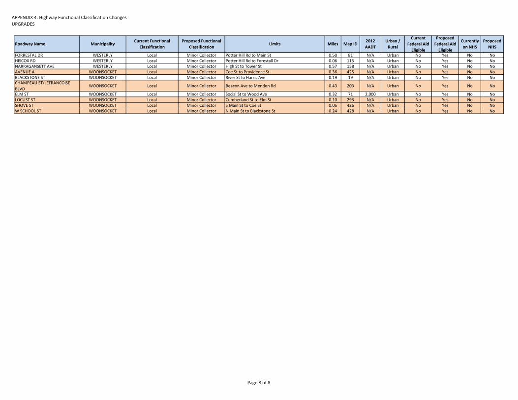
APPENDIX 4: Highway Functional Classification ChangesUPGRADES
Roadway Name MunicipalityCurrent Functional
ClassificationProposed Functional
ClassificationLimits Miles Map ID
2012 AADT
Urban / Rural
Current Federal Aid Eligible
Proposed Federal Aid Eligible
Currently on NHS
Proposed NHS
FORRESTAL DR WESTERLY Local Minor Collector Potter Hill Rd to Main St 0.50 81 N/A Urban No Yes No NoHISCOX RD WESTERLY Local Minor Collector Potter Hill Rd to Forestall Dr 0.06 115 N/A Urban No Yes No NoNARRAGANSETT AVE WESTERLY Local Minor Collector High St to Tower St 0.57 158 N/A Urban No Yes No NoAVENUE A WOONSOCKET Local Minor Collector Coe St to Providence St 0.36 425 N/A Urban No Yes No NoBLACKSTONE ST WOONSOCKET Local Minor Collector River St to Harris Ave 0.19 19 N/A Urban No Yes No NoCHAMPEAU ST/LEFRANCOISE BLVD
WOONSOCKET Local Minor Collector Beacon Ave to Mendon Rd 0.43 203 N/A Urban No Yes No No
ELM ST WOONSOCKET Local Minor Collector Social St to Wood Ave 0.32 71 2,000 Urban No Yes No NoLOCUST ST WOONSOCKET Local Minor Collector Cumberland St to Elm St 0.10 293 N/A Urban No Yes No NoSHOVE ST WOONSOCKET Local Minor Collector S Main St to Coe St 0.06 426 N/A Urban No Yes No NoW SCHOOL ST WOONSOCKET Local Minor Collector N Main St to Blackstone St 0.24 428 N/A Urban No Yes No No
Page 8 of 8

APPENDIX 4: Highway Functional Classification ChangesDOWNGRADES
Roadway Name MunicipalityCurrent Functional Classification
Proposed Functional Classification
Limits MilesMap ID
2012 AADT
Urban / Rural
Current Federal Aid Eligible
Proposed Federal Aid Eligible
Currently on NHS
Proposed NHS
0.54
COUNTY RD N BARRINGTONOther Freeway & Expressway
Other Pricipal Arterial
Wampanoag Trl to before Massasoit Ave 0.54 289 N/A Urban Yes Yes Yes Yes
22.43VETERANS MEMORIAL PKWY EAST PROVIDENCE Other Principal Arterial Minor Arterial I‐195 on‐ramp to Pawtucket Ave 2.74 388 12,700 Urban Yes Yes Yes No
Rt. 14 (PLAINFIELD ST/PIKE)JOHNSTON, CRANSTON, PROVIDENCE
Other Principal Arterial Minor ArterialAtwood Ave (Rt. 5) to Rt. 6E on‐ramp near Pocasset Ave.
2.41 360 18,500 Urban Yes Yes Yes No
Rt. 214 (VALLEY RD) MIDDLETOWN Other Principal Arterial Minor Arterial W Main Rd to Aquidneck Ave. 2.24 386 10,350 Urban Yes Yes Yes NoRt. 108 (POINT JUDITH RD) NARRAGANSETT Other Principal Arterial Minor Arterial Galilee Escape Rd to Ocean Rd 0.42 361 6,100 Urban Yes Yes Yes NoBROADWAY NEWPORT Other Principal Arterial Minor Arterial Farewell St to Marlboro St 0.10 280 N/A Urban Yes Yes Yes NoTHAMES ST NEWPORT Other Principal Arterial Minor Arterial Washington Sq. to America's Cup Ave. 0.17 429 2,700 Urban Yes Yes Yes NoWASHINGTON SQ NEWPORT Other Principal Arterial Minor Arterial Thames St to Farewell St 0.12 391 N/A Urban Yes Yes Yes NoARMISTICE BLVD PAWTUCKET Other Principal Arterial Minor Arterial Grove St to Daggett Ave 2.79 269 7,400 Urban Yes Yes Yes NoBROAD ST PAWTUCKET Other Principal Arterial Minor Arterial Goff Ave To Main St 0.10 279 N/A Urban Yes Yes Yes NoBROADWAY PAWTUCKET Other Principal Arterial Minor Arterial School St. to Exchange St 0.30 281 14,000 Urban Yes Yes Yes NoRt. 15 (CHURCH ST) PAWTUCKET Other Principal Arterial Minor Arterial Mineral Spring Ave to Pine St 0.07 285 N/A Urban Yes Yes Yes NoRt. 114 (COTTAGE ST) PAWTUCKET Other Principal Arterial Minor Arterial Exchange St. to Underwood St 0.10 288 N/A Urban Yes Yes Yes NoRt. 15 (DENVER ST) PAWTUCKET Other Principal Arterial Minor Arterial Spring St to Armistice Blvd 0.05 291 N/A Urban Yes Yes Yes NoRt. 114 (EXCHANGE ST) PAWTUCKET Other Principal Arterial Minor Arterial Broadway to Cottage St 0.06 301 14,300 Urban Yes Yes Yes NoRt. 15 (GROVE ST) PAWTUCKET Other Principal Arterial Minor Arterial Cottage St to Armistice Blvd 0.07 318 2,900 Urban Yes Yes Yes NoKIDS WAY PAWTUCKET Other Principal Arterial Minor Arterial Broadway to Underwood St 0.02 329 N/A Urban Yes Yes Yes NoRt. 122 (LONSDALE AVE) PAWTUCKET Other Principal Arterial Minor Arterial I‐95 on‐ramp to Thurston St 0.23 332 15,800 Urban Yes Yes Yes No
MAIN ST PAWTUCKET Other Principal Arterial Minor Arterial Thurston St./Lonsdale Ave. to Pawtucket Ave 0.71 336 16,200 Urban Yes Yes Yes No
MAIN ST PAWTUCKET Other Principal Arterial Minor Arterial School St to Walcott St. 0.10 337 6,374 Urban Yes Yes Yes No
MAIN ST PAWTUCKET Other Principal Arterial Minor ArterialMineral Spring Ave to Park Place West/Dexter St
0.24 338 N/A Urban Yes Yes Yes No
MAIN ST PAWTUCKET Other Principal Arterial Minor ArterialPark Place West/Dexter St. to East Ave/High St.
0.17 339 N/A Urban Yes Yes Yes No
Rt. 15 (MINERAL SPRING AVE) PAWTUCKET Other Principal Arterial Minor Arterial Lonsdale Ave to Pine St 0.41 343 N/A Urban Yes Yes Yes NoRt. 122 (N MAIN ST) PAWTUCKET Other Principal Arterial Minor Arterial Grenville St/Main St to Pawtucket Ave 0.11 347 6,374 Urban Yes Yes Yes NoRt. 15 (PINE ST) PAWTUCKET Other Principal Arterial Minor Arterial Main St to Church St 0.03 358 N/A Urban Yes Yes Yes NoRt. 15 & Rt. 114 (SPRING ST) PAWTUCKET Other Principal Arterial Minor Arterial Cottage St to Denver St 0.17 375 10,000 Urban Yes Yes Yes NoRt. 114 (UNDERWOOD ST) PAWTUCKET Other Principal Arterial Minor Arterial Broadway to Walcott 0.19 384 N/A Urban Yes Yes Yes NoWALCOTT ST PAWTUCKET Other Principal Arterial Minor Arterial Broadway to Underwood St 0.18 390 8,500 Urban Yes Yes Yes NoS/ ANGELL ST PROVIDENCE Other Principal Arterial Minor Arterial Gano St. to Henderson Bridge 0.53 368 8,000 Urban Yes Yes Yes NoWATERMAN ST PROVIDENCE Other Principal Arterial Minor Arterial Gano St to Henderson Bridge 0.41 394 18,200 Urban Yes Yes Yes No
HENDERSON BRIDGEPROVIDENCE, EAST PROVIDENCE
Other Principal Arterial Minor Arterial Waterman St to N Broadway 1.80 320 19800* Urban Yes Yes Yes No
Rt. 12 (SCITUATE AVE/PHENIX AVE) CRANSTON, SCITUATE Other Principal Arterial Minor Arterial Rt. 116 (North Rd) to Rt. 5 (Atwood Ave) 5.40 367 10,870 Urban /Rural Yes Yes Yes No
0.23
HIGH ST PAWTUCKET Other Principal Arterial Major Collector Summer St to Main St 0.07 321 1,785 Urban Yes Yes Yes NoSUMMER ST PAWTUCKET Other Principal Arterial Major Collector Broad St to High St 0.16 377 N/A Urban Yes Yes Yes No
17.61
RESERVOIR RD BURRILLVILLE Minor Arterial Major Collector S. Main St to Gloucester Border 1.64 365 1100 Rural Yes Yes No No
Downgrade ‐ Other Principal Arterial to Major Collector
Downgrade ‐ Other Freeway & Expressway to Other Principal Arterial
Downgrade ‐ Other Principal Arterial to Minor Arterial
Downgrade ‐ Minor Arterial to Major Collector
Page 1 of 4

APPENDIX 4: Highway Functional Classification ChangesDOWNGRADES
Roadway Name MunicipalityCurrent Functional Classification
Proposed Functional Classification
Limits MilesMap ID
2012 AADT
Urban / Rural
Current Federal Aid Eligible
Proposed Federal Aid Eligible
Currently on NHS
Proposed NHS
SOWAMS RD BARRINGTON Minor Arterial Major Collector New Meadow Rd to Main St 2.17 374 2700 Urban Yes Yes No NoSNAKE HILL RD GLOCESTER Minor Arterial Major Collector Sawmill Rd to W Greenville Rd 1.71 372 N/A Urban Yes Yes No No
W GREENVILLE RDGLOCESTER/ SMITHFIELD
Minor Arterial Major Collector Putnam Pike to Smith Ave 1.11 389 N/A Urban Yes Yes No No
BEAVERTAIL RD JAMESTOWN Minor Arterial Major Collector Fort Getty Rd to Southwest Ave 0.38 274 2400 Urban Yes Yes No NoE SHORE RD JAMESTOWN Minor Arterial Major Collector Middle St to Eldritch Ave 2.67 294 N/A Urban Yes Yes No NoOFF RAMP CONANICUS AVE JAMESTOWN Minor Arterial Major Collector State Highway 138 E to Service Rd 0.55 353 1600 Urban Yes Yes No NoGREENVILLE AVE JOHNSTON Minor Arterial Major Collector Atwood Ave to George Waterman Ave 1.13 317 N/A Urban Yes Yes No NoTHAMES ST NEWPORT Minor Arterial Major Collector Cotton Ct to Mill St 0.08 282 N/A Urban Yes Yes No NoWOONASQUATUCKET AVE NORTH PROVIDENCE Minor Arterial Major Collector Smith St to Fruit Hill Ave 1.71 404 5700 Urban Yes Yes No NoSCHOOL ST NORTH SMITHFIELD Minor Arterial Major Collector Victory Hwy to State Hwy 146 S 0.10 370 N/A Urban Yes Yes No NoACADEMY AVE PROVIDENCE Minor Arterial Major Collector Smith St to Atwells Ave 1.23 266 N/A Urban Yes Yes No NoKENNEDY PLZ PROVIDENCE Minor Arterial Major Collector Dorrance St to Memorial Blvd 0.19 328 N/A Urban Yes Yes No NoMATHEWSON ST PROVIDENCE Minor Arterial Major Collector Fountain St to Waybossett St 0.23 340 N/A Urban Yes Yes No NoWESTMINSTER ST PROVIDENCE Minor Arterial Major Collector Empire St to Memorial Blvd 0.45 396 N/A Urban Yes Yes No NoARNOLD ST WOONSOCKET Minor Arterial Major Collector Railroad St to Main St 0.30 271 N/A Urban Yes Yes No NoBLACKSTONE ST WOONSOCKET Minor Arterial Major Collector Harris Ave to Main St 0.42 276 8000 Urban Yes Yes No NoJOHN A CUMMINGS WAY WOONSOCKET Minor Arterial Major Collector Social St to Clinton St 0.09 326 N/A Urban Yes Yes No NoPOND ST WOONSOCKET Minor Arterial Major Collector Winter St to Clinton St 0.62 362 N/A Urban Yes Yes No NoRIVER ST WOONSOCKET Minor Arterial Major Collector Sayles St to South Main St 0.10 366 N/A Urban Yes Yes No NoWOOD AVE WOONSOCKET Minor Arterial Major Collector Diamond Hill Rd to Cass Ave 0.73 402 N/A Urban Yes Yes No No
2.86
THAMES ST NEWPORT Minor Arterial Minor Collector Parking lot; Mill St to Memorial Blvd 0.18 380 N/A Urban Yes Yes No NoFRUIT HILL AVE NORTH PROVIDENCE Minor Arterial Minor Collector Smithfield Rd to Evans Park 0.73 308 5600 Urban Yes Yes No NoFRICKER ST PROVIDENCE Minor Arterial Minor Collector Cranston St to Broad St 0.15 306 N/A Urban Yes Yes No NoBRIDGE ST WARREN Minor Arterial Minor Collector Water St to Main St 0.16 278 N/A Urban Yes Yes No NoVERNON ST WARREN Minor Arterial Minor Collector Main St to Metacom Ave 0.62 387 2300 Urban Yes Yes No NoWATER ST WARREN Minor Arterial Minor Collector Main St to Bridge St 1.01 393 N/A Urban Yes Yes No No
7.24
WEAVER HILL RDCOVENTRY/WEST GREENWICH
Major Collector Minor Collector Harkney Hill Rd to Fish Hill Rd 1.77 395 500 Rural Yes No No No
BRENTON RD NEWPORT Major Collector Minor Collector Ruggles Ave to Ocean Ave 1.08 277 300 Rural Yes No No NoSAND HILL RD BURRILLVILLE Major Collector Minor Collector Victory Hwy to Main St 0.10 406 N/A Urban Yes Yes No NoKAY ST CUMBERLAND Major Collector Minor Collector Mount Pleasant View Dr to Mendon Ave 0.48 327 N/A Urban Yes Yes No NoMOUNT PLEASANT VIEW AVE CUMBERLAND Major Collector Minor Collector Manville Hill Rd to Kay St 0.40 345 N/A Urban Yes Yes No NoN BROW ST EAST PROVIDENCE Major Collector Minor Collector Waterman Ave to Valley St 0.20 346 N/A Urban Yes Yes No NoBENNETT ST NORTH PROVIDENCE Major Collector Minor Collector Miner St to Lydia Ave 0.19 275 500 Urban Yes Yes No NoLYDIA AVE NORTH PROVIDENCE Major Collector Minor Collector Woodward Rd to Benefit St 0.20 334 500 Urban Yes Yes No NoMINER ST NORTH PROVIDENCE Major Collector Minor Collector Benet St to Charles St 0.06 342 N/A Urban Yes Yes No NoSUPERIOR VIEW BLVD NORTH PROVIDENCE Major Collector Minor Collector Reservoir Ave to High Service Ave 0.37 378 N/A Urban Yes Yes No No
COLLEGE RDNORTH PROVIDENCE/ PROVIDENCE
Major Collector Minor Collector Fruit Hill Ave to Mount Pleasant Ave 0.86 287 N/A Urban Yes Yes No No
EDDY ST PROVIDENCE Major Collector Minor Collector Fountain St to Washington St 0.07 296 N/A Urban Yes Yes No NoUNION ST PROVIDENCE Major Collector Minor Collector Fountain St to Washington St 0.07 385 N/A Urban Yes Yes No NoWHIPPLE AVE SMITHFIELD Major Collector Minor Collector Cross St to ST Michaels Wy 0.23 397 N/A Urban Yes No No NoELM ST WOONSOCKET Major Collector Minor Collector Wood Ave to Cass Ave 0.62 297 N/A Urban Yes Yes No No
Downgrade ‐ Minor Arterial to Minor Collector
Downgrade ‐ Major Collector to Minor Collector
Page 2 of 4
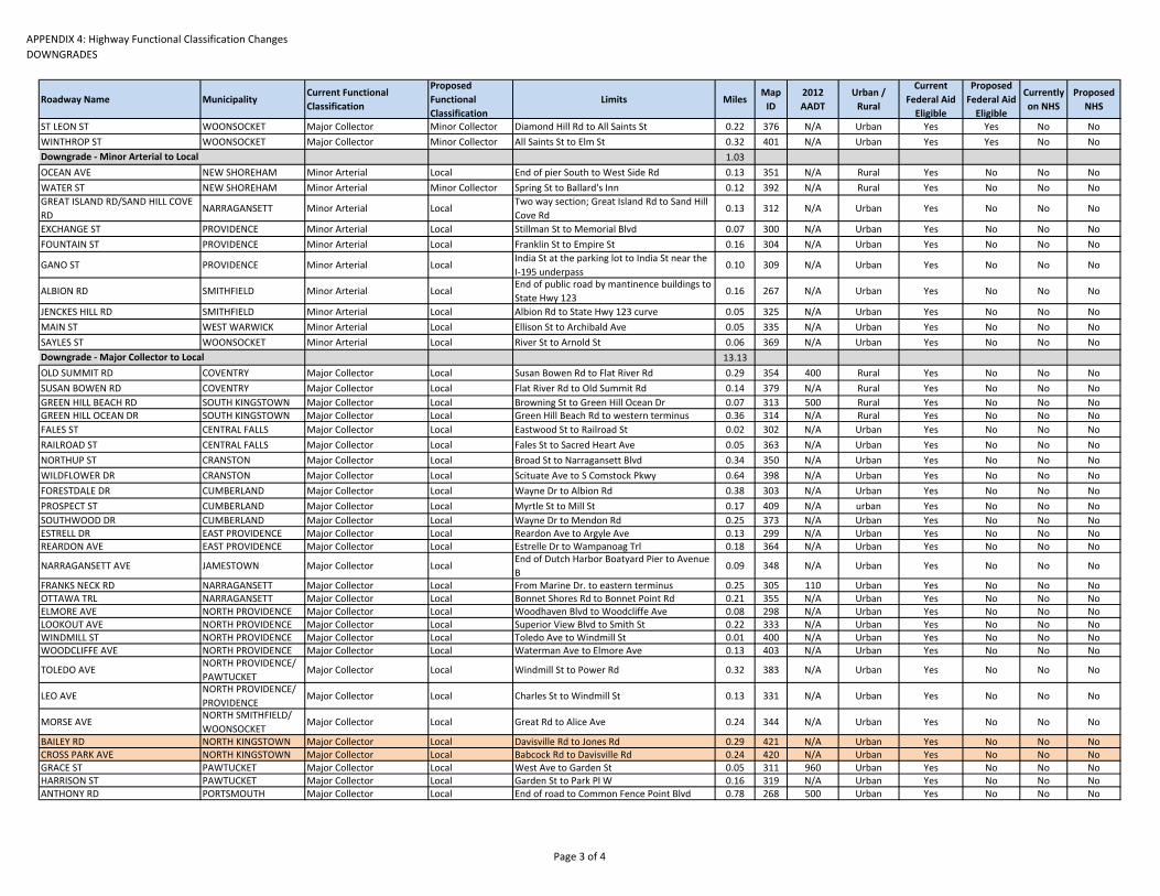
APPENDIX 4: Highway Functional Classification ChangesDOWNGRADES
Roadway Name MunicipalityCurrent Functional Classification
Proposed Functional Classification
Limits MilesMap ID
2012 AADT
Urban / Rural
Current Federal Aid Eligible
Proposed Federal Aid Eligible
Currently on NHS
Proposed NHS
ST LEON ST WOONSOCKET Major Collector Minor Collector Diamond Hill Rd to All Saints St 0.22 376 N/A Urban Yes Yes No NoWINTHROP ST WOONSOCKET Major Collector Minor Collector All Saints St to Elm St 0.32 401 N/A Urban Yes Yes No No
1.03OCEAN AVE NEW SHOREHAM Minor Arterial Local End of pier South to West Side Rd 0.13 351 N/A Rural Yes No No NoWATER ST NEW SHOREHAM Minor Arterial Minor Collector Spring St to Ballard's Inn 0.12 392 N/A Rural Yes No No NoGREAT ISLAND RD/SAND HILL COVE RD
NARRAGANSETT Minor Arterial LocalTwo way section; Great Island Rd to Sand Hill Cove Rd
0.13 312 N/A Urban Yes No No No
EXCHANGE ST PROVIDENCE Minor Arterial Local Stillman St to Memorial Blvd 0.07 300 N/A Urban Yes No No NoFOUNTAIN ST PROVIDENCE Minor Arterial Local Franklin St to Empire St 0.16 304 N/A Urban Yes No No No
GANO ST PROVIDENCE Minor Arterial LocalIndia St at the parking lot to India St near the I‐195 underpass
0.10 309 N/A Urban Yes No No No
ALBION RD SMITHFIELD Minor Arterial LocalEnd of public road by mantinence buildings to State Hwy 123
0.16 267 N/A Urban Yes No No No
JENCKES HILL RD SMITHFIELD Minor Arterial Local Albion Rd to State Hwy 123 curve 0.05 325 N/A Urban Yes No No NoMAIN ST WEST WARWICK Minor Arterial Local Ellison St to Archibald Ave 0.05 335 N/A Urban Yes No No NoSAYLES ST WOONSOCKET Minor Arterial Local River St to Arnold St 0.06 369 N/A Urban Yes No No No
13.13OLD SUMMIT RD COVENTRY Major Collector Local Susan Bowen Rd to Flat River Rd 0.29 354 400 Rural Yes No No NoSUSAN BOWEN RD COVENTRY Major Collector Local Flat River Rd to Old Summit Rd 0.14 379 N/A Rural Yes No No NoGREEN HILL BEACH RD SOUTH KINGSTOWN Major Collector Local Browning St to Green Hill Ocean Dr 0.07 313 500 Rural Yes No No NoGREEN HILL OCEAN DR SOUTH KINGSTOWN Major Collector Local Green Hill Beach Rd to western terminus 0.36 314 N/A Rural Yes No No NoFALES ST CENTRAL FALLS Major Collector Local Eastwood St to Railroad St 0.02 302 N/A Urban Yes No No NoRAILROAD ST CENTRAL FALLS Major Collector Local Fales St to Sacred Heart Ave 0.05 363 N/A Urban Yes No No NoNORTHUP ST CRANSTON Major Collector Local Broad St to Narragansett Blvd 0.34 350 N/A Urban Yes No No NoWILDFLOWER DR CRANSTON Major Collector Local Scituate Ave to S Comstock Pkwy 0.64 398 N/A Urban Yes No No NoFORESTDALE DR CUMBERLAND Major Collector Local Wayne Dr to Albion Rd 0.38 303 N/A Urban Yes No No NoPROSPECT ST CUMBERLAND Major Collector Local Myrtle St to Mill St 0.17 409 N/A urban Yes No No NoSOUTHWOOD DR CUMBERLAND Major Collector Local Wayne Dr to Mendon Rd 0.25 373 N/A Urban Yes No No NoESTRELL DR EAST PROVIDENCE Major Collector Local Reardon Ave to Argyle Ave 0.13 299 N/A Urban Yes No No NoREARDON AVE EAST PROVIDENCE Major Collector Local Estrelle Dr to Wampanoag Trl 0.18 364 N/A Urban Yes No No No
NARRAGANSETT AVE JAMESTOWN Major Collector LocalEnd of Dutch Harbor Boatyard Pier to Avenue B
0.09 348 N/A Urban Yes No No No
FRANKS NECK RD NARRAGANSETT Major Collector Local From Marine Dr. to eastern terminus 0.25 305 110 Urban Yes No No NoOTTAWA TRL NARRAGANSETT Major Collector Local Bonnet Shores Rd to Bonnet Point Rd 0.21 355 N/A Urban Yes No No NoELMORE AVE NORTH PROVIDENCE Major Collector Local Woodhaven Blvd to Woodcliffe Ave 0.08 298 N/A Urban Yes No No NoLOOKOUT AVE NORTH PROVIDENCE Major Collector Local Superior View Blvd to Smith St 0.22 333 N/A Urban Yes No No NoWINDMILL ST NORTH PROVIDENCE Major Collector Local Toledo Ave to Windmill St 0.01 400 N/A Urban Yes No No NoWOODCLIFFE AVE NORTH PROVIDENCE Major Collector Local Waterman Ave to Elmore Ave 0.13 403 N/A Urban Yes No No No
TOLEDO AVENORTH PROVIDENCE/ PAWTUCKET
Major Collector Local Windmill St to Power Rd 0.32 383 N/A Urban Yes No No No
LEO AVENORTH PROVIDENCE/ PROVIDENCE
Major Collector Local Charles St to Windmill St 0.13 331 N/A Urban Yes No No No
MORSE AVENORTH SMITHFIELD/ WOONSOCKET
Major Collector Local Great Rd to Alice Ave 0.24 344 N/A Urban Yes No No No
BAILEY RD NORTH KINGSTOWN Major Collector Local Davisville Rd to Jones Rd 0.29 421 N/A Urban Yes No No NoCROSS PARK AVE NORTH KINGSTOWN Major Collector Local Babcock Rd to Davisville Rd 0.24 420 N/A Urban Yes No No NoGRACE ST PAWTUCKET Major Collector Local West Ave to Garden St 0.05 311 960 Urban Yes No No NoHARRISON ST PAWTUCKET Major Collector Local Garden St to Park Pl W 0.16 319 N/A Urban Yes No No NoANTHONY RD PORTSMOUTH Major Collector Local End of road to Common Fence Point Blvd 0.78 268 500 Urban Yes No No No
Downgrade ‐ Minor Arterial to Local
Downgrade ‐ Major Collector to Local
Page 3 of 4

APPENDIX 4: Highway Functional Classification ChangesDOWNGRADES
Roadway Name MunicipalityCurrent Functional Classification
Proposed Functional Classification
Limits MilesMap ID
2012 AADT
Urban / Rural
Current Federal Aid Eligible
Proposed Federal Aid Eligible
Currently on NHS
Proposed NHS
MCCORRIE LN PORTSMOUTH Major Collector Local William St to eastern beach access terminus 0.02 341 N/A Urban Yes No No No
ARNOLD ST PROVIDENCE Major Collector Local Benefit St to Brook St 0.19 270 N/A Urban Yes No No NoBAKER ST PROVIDENCE Major Collector Local Broad St to Eddy St 0.21 272 N/A Urban Yes No No NoCLAVERICK ST PROVIDENCE Major Collector Local Broad St to Pine St 0.08 286 N/A Urban Yes No No NoFRIENDSHIP ST PROVIDENCE Major Collector Local Plain St to E Franklin St 0.08 307 N/A Urban Yes No No NoGOVERNOR ST PROVIDENCE Major Collector Local Pitman St to Wickenden St 0.43 310 N/A Urban Yes No No NoGREENE ST PROVIDENCE Major Collector Local Fountain St to Broad St 0.22 315 N/A Urban Yes No No NoGREENMAN LN PROVIDENCE Major Collector Local Broadway to Fountain St 0.06 316 N/A Urban Yes No No NoHUXLEY AVE PROVIDENCE Major Collector Local Admiral St to Eaton St 0.37 322 N/A Urban Yes No No NoNASHUA ST PROVIDENCE Major Collector Local Smithfield Ave to Front St 0.14 349 N/A Urban Yes No No NoPITMAN ST PROVIDENCE Major Collector Local Governor St to Ives St 0.06 359 N/A Urban Yes No No NoSHERRY ST PROVIDENCE Major Collector Local Dexter St to Potters Ave 0.09 371 N/A Urban Yes No No NoTHAYER ST PROVIDENCE Major Collector Local Power St to Arnold St 0.13 382 N/A Urban Yes No No No
OCEAN AVE SOUTH KINGSTOWN Major Collector Local Peninsula Rd to eastern shoreline terminus 0.32 352 N/A Urban Yes No No No
PENINSULA RD SOUTH KINGSTOWN Major Collector Local Ocean Ave to Matunuck Beach Rd 0.07 356 N/A Urban Yes No No NoWOLF HILL RD SMITHFIELD Major Collector Local Farnum Pike to Old County Rd 0.19 424 N/A Urban Yes No No NoWHIPPLE AVE SMITHFIELD Major Collector Local Farnum Pike to St. Michael's Way 0.09 430 N/A Urban Yes No No NoBAYVIEW AVE WARWICK Major Collector Local Love Ln to Post Rd 0.51 273 N/A Urban Yes No No No
BUTTONWOODS AVE WARWICK Major Collector LocalAndrew Comstock St to eastern terminus past 15th Ave
0.91 283 N/A Urban Yes No No No
IVES RD WARWICK Major Collector LocalBradford Ave to eastern beach access terminus
0.07 323 N/A Urban Yes No No No
PETTACONSETT AVE WARWICK Major Collector Local Broad St to Post Rd 0.51 357 2000 Urban Yes No No NoJAMES P MURPHY IND RD WEST WARWICK Major Collector Local end of road to Energy Way 0.41 324 5600 Urban Yes No No No3RD AVE WOONSOCKET Major Collector Local Rhodes Ave to Mason St 0.59 265 N/A Urban Yes No No NoCARRINGTON AVE WOONSOCKET Major Collector Local Park Ave to Manville Rd 0.42 284 N/A Urban Yes No No NoDAVISON AVE WOONSOCKET Major Collector Local Hamlet Ave to Manville Rd 0.22 290 5400 Urban Yes No No NoKNIGHT ST WOONSOCKET Major Collector Local Logee St to Cottage St 0.03 330 N/A Urban Yes No No NoWILLOW ST WOONSOCKET Major Collector Local Park Ave to Manville Rd 0.51 399 N/A Urban Yes No No No
0.50
E BEACH RD CHARLESTOWN Minor Collector LocalFrom Blue Shutters beach to the end of the road well past East Beach parking lot
0.50 292 N/A Rural No No No No
Downgrade ‐ Minor Collector to Local
Page 4 of 4

APPENDIX 5:
Highway Functional Classification Map

217
292
160
314
76
313
417
416
S COU NTY TRL
E BEACH R D
COM M ODO RE PER RY HWY SNARR
OW LN
FALCO NE LN
GREE N HILL O CEAN D R
I 95
S
I 95
N
I 295 S
I 295 N
I 195 WI 195 E
STATE HWY 146 S
STATE HW
Y 146 N
STATE HWY 4 N
STATE HW
Y 4 S
POST RD
STATE HWY 24 S
TOW
ER
HILL R
D
US HWY 6 W
STATE HWY 138 W
STAT
E H
WY
78 S
US HW
Y 6 E
STATE HWY 37 W
PELL BRIDGE
WAM
PANO
AG TR
L
US HW
Y 1
N
PUTNAM PIKE
E M
AIN
RD
W M
AIN
RD
S C
OU
NTY
TR
L
TEN ROD RD
DOUGLAS PIKE
EAST R
D
SMITH ST
MAI
N ST
CH
OP
MIS
T H
ILL
RD
HO
PE S
T
FLAT RIVER RD
ME
TAC
OM
AVE
DANIELSON PIKE
US HWY 6
WARW
ICK AVE
PARK AVE
BRO
NCO
S HW
YPAW
TUCKET AVE
DOUGLAS AVE
SPRING ST
KINGSTOWN RD
BRO
AD S
T
PLAIN
FIELD P
IKE
MAIN AVE
POIN
T JU
DIT
H R
D
DIAM
ON
D H
ILL RD
MENDON RD
NO
RTH
RD CHILD ST
SMITH
FIELD
AVE
VICT
ORY H
WY
W G
RE
EN
VILL
E R
D
HARTFORD AVE
DAVISVILLE RD
FERR
Y RD
1ST AVE
GREENVILLE AVEW
ILLETT AVE
CENTERVILLE RD
HIG
H S
T
POST RD
TIOGUE AVEPO
ST R
D
POST R
D
DIAMOND HILL RD
POST R
D
VIC
TOR
Y H
WY
SPRING ST
PLAINFIELD PIKE
PAR
K AV
E
BROAD ST
INTERSTATE 195
INTE
RSTA
TE 9
5
INTERSTATE 495
MAI
N R
OAD
RO
UTE
24
BAY
RO
AD
RO
UTE
79
CO
UN
TY S
TREE
T
WINTHROP STREET
BRO
ADW
AY
TREMONT STREET
ELM
STR
EET
HIG
H ST
WIL
LIAM
S S
TREE
T
SOD
OM
RO
AD
BER
KLEY
STR
EET
RIVER ROAD
BLO
SS
OM
RO
AD
BAY
VIEW
AVE
NU
E
PLAIN
STRE
ET
PIKE AVENU
E
SUMMER STREET
FAIRVIEW AVENUE
BUR
T STR
EE
T
LIND
SEY STREET
OAKHILL AVENUE
PINE STREETNORTON AVENUE
BRIGGS ROAD
MA
SO
N S
TREE
T
RO
BESO
N S
TREE
T
OLD
PO
ST R
OA
D
GILBERT STREET
MEN
DO
N R
OAD
PUR
CH
ASE
STR
EET
ASH STREET
MAPLE STREET
OAK STREET
ELM STREET
ROUTE 24
RO
UTE
24
State of Rhode Island Map Created on July 8, 2014
This map is not the product of a Professional Land Survey. It was created by RI Statewide Planning Program for general reference,informational, planning and guidance use, and is not a legally authoritative source as to location of natural or manmade features. Proper interpretation of this map may require the assistance of appropriate professional services. RI Statewide Planning Program makes no warranty, express or implied, related to the spatial accuracy, reliability, completeness, or currentness of this map.
[
0 5.5 112.75 MilesLegendProposed Roadway Classification
Interstate
Freeway
Principal Arterial
Minor Arterial
Major Collector
Minor Collector
Proposed Roadway Functional ClassificationC
OR
N N
ECK R
D
WES
T SI
DE R
D