

State of GIS in Colorado
28
State of GIS in the State of Colorado Nathan Lowry, GIS Outreach Coordinator GIS Colorado Winter Meeting, Fort Collins, CO January 23, 2015 http://www.buyfortcollinshomes.com/wp-content/uploads/2013/03/Pats-Jan-photos-001.jpg
-
Upload
gis-colorado -
Category
Technology
-
view
84 -
download
0
Transcript of State of GIS in Colorado

State of GIS in theState of Colorado
Nathan Lowry, GIS Outreach CoordinatorGIS Colorado Winter Meeting, Fort Collins, CO
January 23, 2015
http://www.buyfortcollinshomes.com/wp-content/uploads/2013/03/Pats-Jan-photos-001.jpg

Governor's Office of Information Technology (OIT) April 2014 Governor Visit
GIS Data Coordination and Services
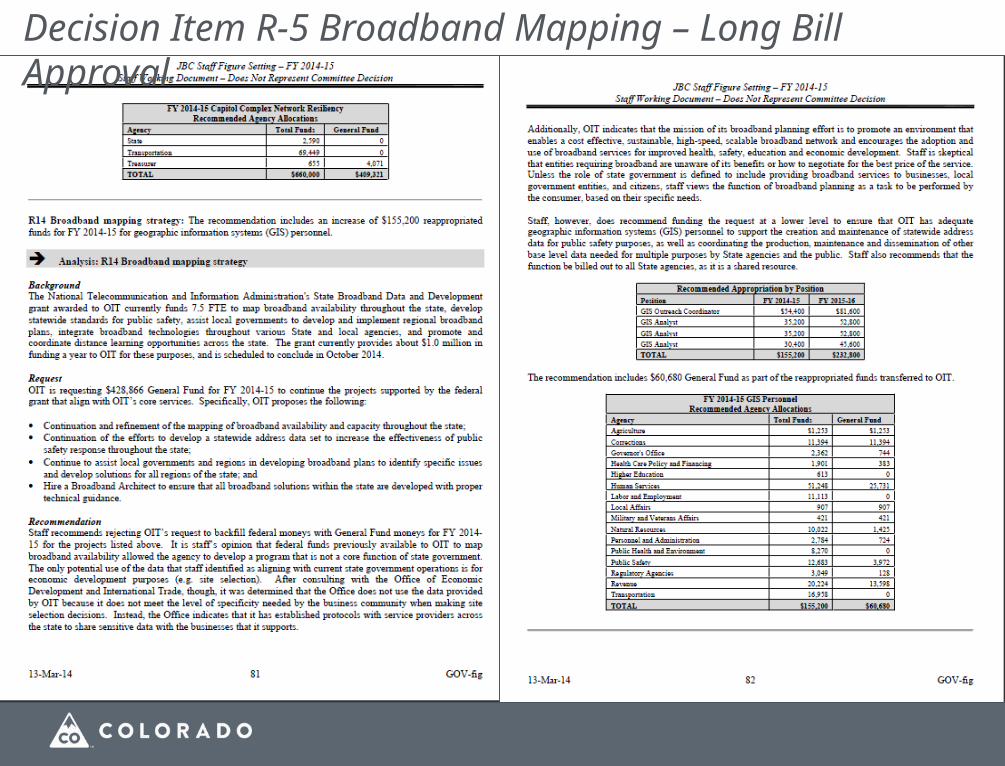
Decision Item R-5 Broadband Mapping – Long Bill Approval

Data Plan
Discovery - Searchable inventory of state GIS data in CIM . Single answer for first question, “Who has what data, and how can I get it?” Foundation of further steps.
Access - Next question, “How can users easily get the data that is available,” and this will produce combination of access modes including using state agencies’ infrastructure.
Data management - Stewardship program producing seamless statewide data sets essential for many tasks. Many of these data aggregate local and other data. Significant work is required to integrate them into standard structure.
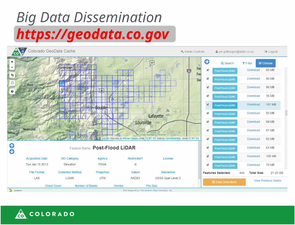
Big Data Disseminationhttps://geodata.co.gov

Colorado Enterprise Web Map Serviceshttp://maps.co.gov/COPubGIS/rest/serviceshttp://gis.co.gov/oitprod10/rest/services

Data Under Active StewardshipHydrography (DNR)
Municipal boundaries (DOLA)
Address Points (OIT)
Community Facilities
Parcels
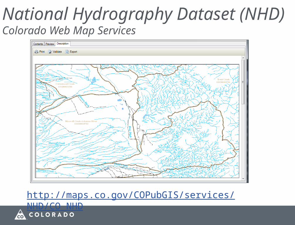
National Hydrography Dataset (NHD)Colorado Web Map Services
http://maps.co.gov/COPubGIS/services/NHD/CO_NHD

Municipal Boundaries

Addresses: Automated Processes
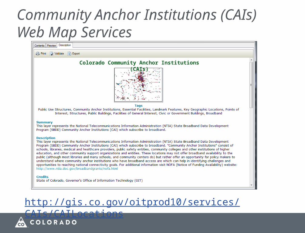
Community Anchor Institutions (CAIs)Web Map Services
Colorado Community Anchor Institutions (CAIs)
http://gis.co.gov/oitprod10/services/CAIs/CAILocations

State GeoShare https://gisftp02.state.co.usSFTP-enabled Managed File Transfer site.
• Secure (encrypted) large-file transfer service - managed by OIT
• User authenticated accounts, files are encrypted in transit
• WEBDAV protocol for communication and transfer

High Level Plan

Google Groups for Communication

Mature Intermediate Struggling/small/starting Interested
CDOT DOLA History CO DoR
CDPHE DMVA DoA CDLE
OIT CDPS CEO CDHS
DNR OEDIT HCPF
(Land Board) DORA DoE
(Water Resources) SoS
(CWCB)
(OGCC)
(DRMS)
(Parks & Wildlife)
Situation - State GIS
More dedicated GIS staff
More use of web map services/robust applications

Statutory Responsibilities:Colorado Revised Statutes 24-37.5-106 (1) The chief information officer shall:(c) Coordinate and direct the formulation and promulgation of policies, standards, specifications, and guidelines for information technology in state agencies including but not limited to those required to support state and local government exchange, acquisition, storage, use, sharing, and distribution of geographic or base map data and related technologies;
24-37.5-111. Geographic information system - coordinator - statewide planOn and after July 1, 2008, all duties and responsibilities for statewide geographic information system coordination shall be transferred from the department of local affairs to the office. The office shall develop a statewide geographic information system plan on or before July 1, 2010, and submit such plan to the governor and to the state, veterans, and military affairs committees of the senate and the house of representatives, or their successor committees.

Who: local governments responsible for county-wide thematic data (counties, regions)
When: Issued by email week of 19 Jan 2015 (next week); 6-8 week response time
Coordinated w/Denver Regional Council of Governments (DRCOG)
● Timing coincident with DRDC data call
● Mostly the same content
Means of data transfer:
Secure:
● State GeoShare Managed File Transfer (MFT) site (SFTP, WEBDAV, etc.)
● DRDC Data Portal, CIM (data.colorado.gov)
Open:
● OpenColorado.org
● Local government websites
● Email, etc.
Winter 2015 Data Call: Schedule
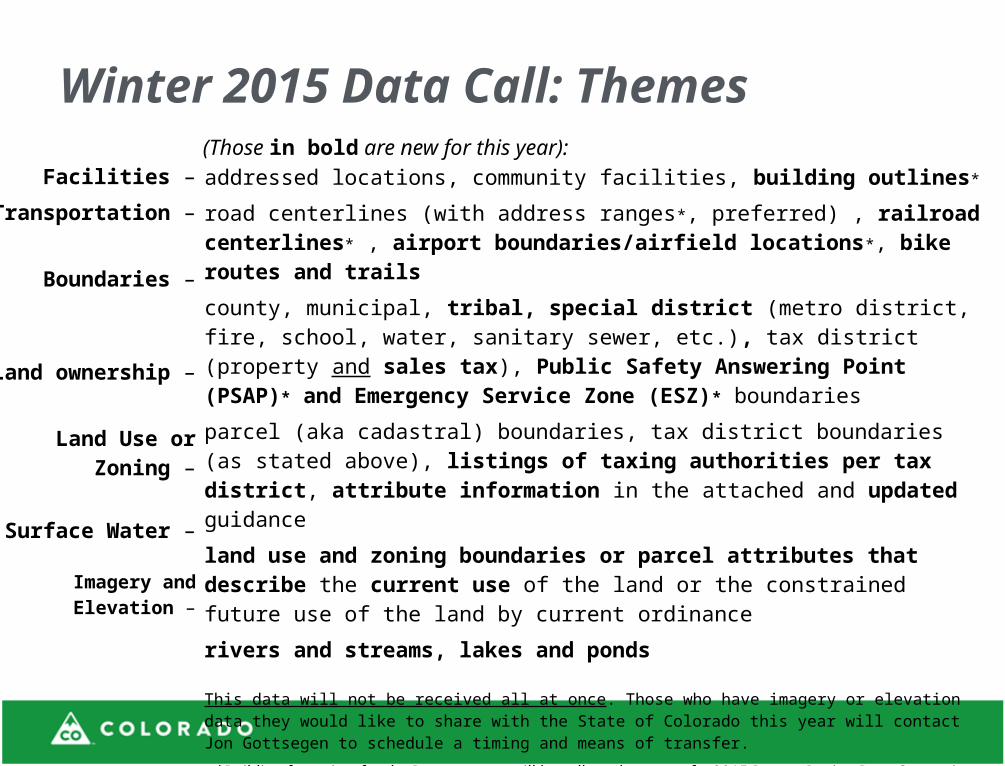
addressed locations, community facilities, building outlines*
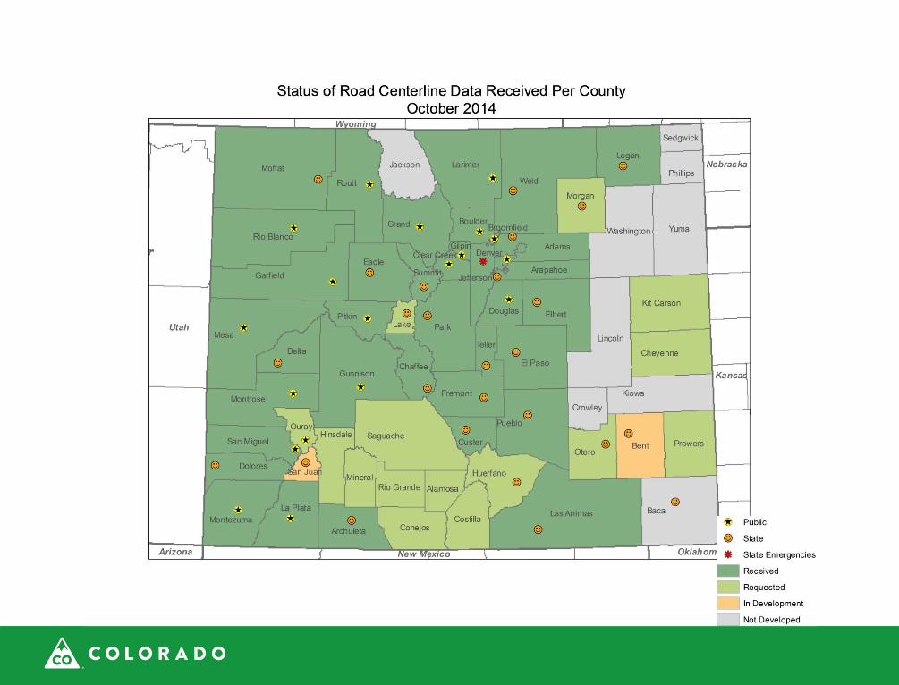
road centerlines (with address ranges*, preferred) , railroad centerlines* , airport boundaries/airfield locations*, bike routes and trails
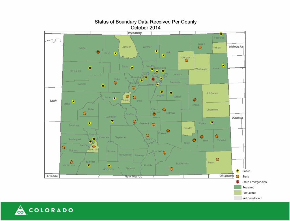
county, municipal, tribal, special district (metro district, fire, school, water, sanitary sewer, etc.), tax district (property and sales tax), Public Safety Answering Point (PSAP)* and Emergency Service Zone (ESZ)* boundaries
parcel (aka cadastral) boundaries, tax district boundaries (as stated above), listings of taxing authorities per tax district, attribute information in the attached and updated guidance
land use and zoning boundaries or parcel attributes that describe the current use of the land or the constrained future use of the land by current ordinance
rivers and streams, lakes and ponds
This data will not be received all at once. Those who have imagery or elevation data they would like to share with the State of Colorado this year will contact Jon Gottsegen to schedule a timing and means of transfer.
*Building footprints for the Denver metro will be collected as part of a 2015 Denver Region Data Consortium (DRDC) region -wide plannimetric project and distributed publically by the Denver Regional Council of Governments (DRCOG). Collection of road and railroad centerlines, airport boundaries/airfield locations, and PSAP and ESZ boundaries for the Denver metro will occur via the North Central All-Hazards Region (NCR) rather than the DRDC. DRCOG will also request Open Space, Building Permits, and Employment/Business Data from local governments for the Denver metro.
Facilities –
Transportation –
Boundaries –
Land ownership –
Land Use or Zoning –
Surface Water –
Imagery and Elevation –
Winter 2015 Data Call: Themes
(Those in bold are new for this year):
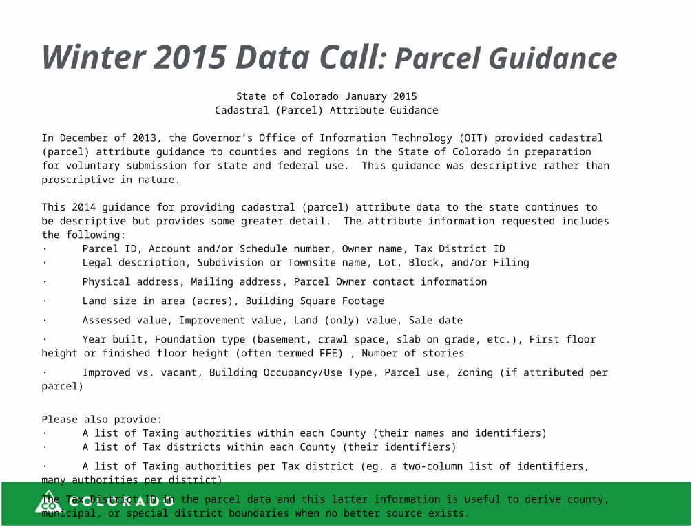
Winter 2015 Data Call: Parcel Guidance State of Colorado January 2015
Cadastral (Parcel) Attribute Guidance
In December of 2013, the Governor’s Office of Information Technology (OIT) provided cadastral (parcel) attribute guidance to counties and regions in the State of Colorado in preparation for voluntary submission for state and federal use. This guidance was descriptive rather than proscriptive in nature. This 2014 guidance for providing cadastral (parcel) attribute data to the state continues to be descriptive but provides some greater detail. The attribute information requested includes the following:· Parcel ID, Account and/or Schedule number, Owner name, Tax District ID· Legal description, Subdivision or Townsite name, Lot, Block, and/or Filing
· Physical address, Mailing address, Parcel Owner contact information
· Land size in area (acres), Building Square Footage
· Assessed value, Improvement value, Land (only) value, Sale date
· Year built, Foundation type (basement, crawl space, slab on grade, etc.), First floor height or finished floor height (often termed FFE) , Number of stories
· Improved vs. vacant, Building Occupancy/Use Type, Parcel use, Zoning (if attributed per parcel)
Please also provide: · A list of Taxing authorities within each County (their names and identifiers)· A list of Tax districts within each County (their identifiers)
· A list of Taxing authorities per Tax district (eg. a two-column list of identifiers, many authorities per district)
The Tax District ID in the parcel data and this latter information is useful to derive county, municipal, or special district boundaries when no better source exists.
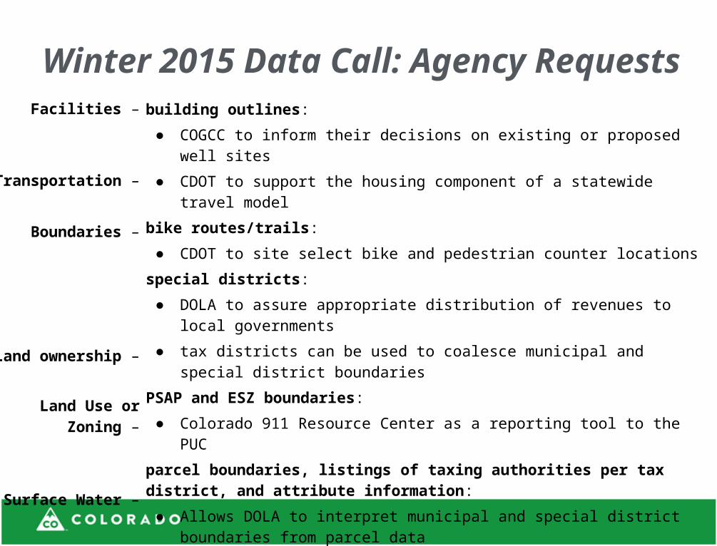
building outlines:
● COGCC to inform their decisions on existing or proposed well sites
● CDOT to support the housing component of a statewide travel model
bike routes/trails :
● CDOT to site select bike and pedestrian counter locations
special districts:
● DOLA to assure appropriate distribution of revenues to local governments
● tax districts can be used to coalesce municipal and special district boundaries
PSAP and ESZ boundaries:
● Colorado 911 Resource Center as a reporting tool to the PUC
parcel boundaries, listings of taxing authorities per tax district, and attribute information:
● Allows DOLA to interpret municipal and special district boundaries from parcel data
zoning:
● Informs COGCC decisions on existing or proposed well sites
● Supports CDOT’s housing component of a statewide travel model
Colorado 811 request; may inform agencies of varying interpretations of waterways
Facilities –
Transportation –
Boundaries –
Land ownership –
Land Use or Zoning –
Surface Water –
Winter 2015 Data Call: Agency Requests


Delivering Results: National Governors Association Chair’s Initiative 2014-2015
“But changing the how is not limited to digital services—it includes a variety of other technologies, notably geographic information systems to improve land use planning and disaster response.”

Jon Gottsegen
303-764-7712
Nathan Lowry
303-764-7801
Thank You

"Fort Collins Historic District" by Wusel007 - Own work. Licensed under CC BY-SA 3.0 via Wikimedia Commons - http://commons.wikimedia.org/wiki/File:Fort_Collins_Historic_District.JPG#mediaviewer/File:Fort_Collins_Historic_District.JPG


