Start on Market St Bridge by the City Island entrances...
26
2017 Half Marathon Course Start on Market St Bridge by the City Island entrances/exits, head towards South Front St in Wormleysburg. Turn right onto South Front St at the end of the bridge (turn one). After making this turn, stay on the shoulder of the road until the sidewalk begins on the other side of the street, near Duke’s restaurant. Please use caution when crossing the road. Rockbass Grill Dockside Willies Turn One Market St Bridge Starting line is located adjacent to the bus shelter
Transcript of Start on Market St Bridge by the City Island entrances...

2017 Half Marathon Course
Start on Market St Bridge by the City Island entrances/exits, head towards South Front St in Wormleysburg.
Turn right onto South Front St at the end of the bridge (turn one). After making this turn, stay on the shoulder of the road until the sidewalk begins on the other side of the street, near Duke’s restaurant. Please use caution when crossing the road.
Rockbass Grill
Dockside Willies
Turn One
Market St Bridge
Starting line is located adjacent to the bus shelter

2017 Half Marathon Course
Follow the sidewalk along South Front St until you turn left on Elm St (turn two) Stay on Elm St until you turn right onto 2nd St (turn three) Stay on 2nd St until you turn right onto the walking lane of the Harvey Taylor Bridge – head towards the city (turn four)
(close-ups on next page)
Turn One
Turn Two Elm St
Turn Three 2nd St
Turn Four Harvey Taylor
Bridge

2017 Half Marathon Course
Turn Two Elm St
Turn Three 2nd St
Turn Four Harvey Taylor
Bridge
Elm St
2nd
St
Harvey Taylor Bridge walking lane

2017 Half Marathon Course
When you get to Front St, bear right (turn five) and follow the coned off lane on Front St until you reach the Walnut St Bridge.
Turn Five
Front St
Greenbelt Path starts here

2017 Half Marathon Course
Continue on the coned off lane on Front St until you reach the Walnut St Bridge area
Walnut St Bridge

2017 Half Marathon Course
When you get to the Walnut St walking bridge, bear to the right (turn six) and follow the ramp down to the lower level path, then continue heading south on the lower level Greenbelt path.
Turn Six

2017 Half Marathon Course
After going down the ramp at the Walnut St Bridge, continue straight on the lower level Greenbelt path until you reach the ramp to South Front St
See close up of turn on next
page for turns seven and eight

2017 Half Marathon Course
Turn left (turn seven) and go up the ramp towards South Front St. Immediately at the top of the ramp make a sharp right (turn eight) and then follow the Greenbelt path (not the road!)
Turn Seven
Turn Eight

2017 Half Marathon Course
Continue following the upper level Greenbelt path until you reach the end of the path. Make a quick left (turn nine) onto the road and then a quick right (turn ten) to head south on Front St towards Penndot.
Turn Nine
Turn Ten

2017 Half Marathon Course
Continue following the South Front St until you turn left (turn eleven) onto Sycamore St.
Turn Eleven
Sycamore St
South Front St

2017 Half Marathon Course
Continue following Sycamore St until you turn right (turn twelve) onto South Cameron St. Continue following South Cameron St until you make a turn onto the Greenbelt Path (this will be approximately .5 miles down the road)
Turn Twelve

2017 Half Marathon Course
Make a sharp right turn (turn thirteen) off South Cameron St and make a “u-turn” onto the Greenbelt Path. Continue following the Greenbelt Path all the way until you come back out at the Penndot building.
Turn Thirteen

2017 Half Marathon Course
Continue following the Greenbelth Path all the way until you come back to Penndot, where you will then bear left and continue onto the Greenbelt Path (see next page)
2017 Half Marathon Course
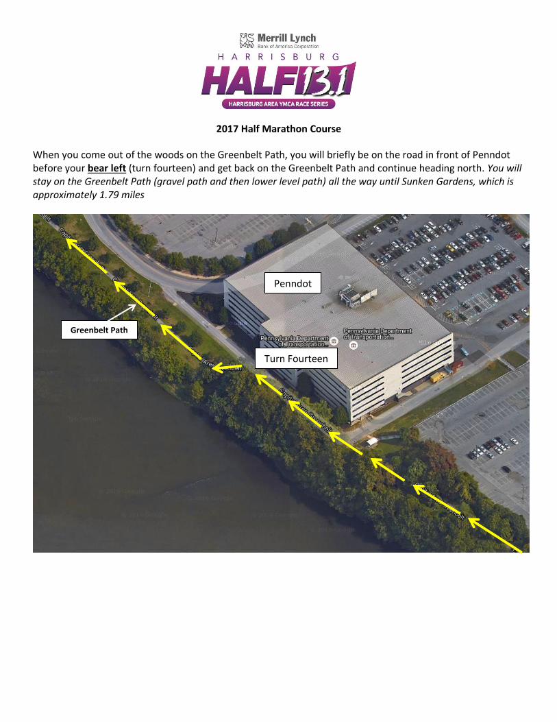
When you come out of the woods on the Greenbelt Path, you will briefly be on the road in front of Penndot before your bear left (turn fourteen) and get back on the Greenbelt Path and continue heading north. You will stay on the Greenbelt Path (gravel path and then lower level path) all the way until Sunken Gardens, which is approximately 1.79 miles
Turn Fourteen
Greenbelt Path
Penndot

2017 Half Marathon Course
Continue following lower level Greenbelt Path all the way to Sunken Gardens….

2017 Half Marathon Course
Continue following lower level Greenbelt Path all the way to Sunken Gardens….

2017 Half Marathon Course
Continue following lower level Greenbelt Path all the way to Sunken Gardens….

2017 Half Marathon Course
Continue following lower level Greenbelt Path all the way to Sunken Gardens….

2017 Half Marathon Course Continue following lower level Greenbelt Path all the way until just past the Harvey Taylor Bridge. You will turn right (turn fifteen) and head up the ramp towards Sunken Gardens, where you will then continue north on the Greenbelt Path and a coned off lane of Front St until you reach the turnaround point.
Turn Fifteen Go up the ramp to Sunken
Gardens. This ramp is just past the Harvey Taylor Bridge!
See Close-up on next page for Sunken Gardens close-up
Sunken Gardens

2017 Half Marathon Course
Sunken Gardens Close-Up
When you get to the top of Sunken Gardens, continue heading north on the Greenbelt Path.
.
North
South

2017 Half Marathon Course
After going up the Sunken Gardens Ramp, you will stay on the Greenbelt Path until you reach Maclay St, which is where you will make the transition to a coned off lane of Front St. The length traveled on the upper level path will be approximately .86 miles until the Maclay St merge onto Front St.

2017 Half Marathon Course
At this point, you will merge slightly to the right (turn sixteen) from the upper level Greenbelt path onto a coned off lane of Front St and continue heading north. You will head north approximately 1.49 miles until the turnaround point just south of Lewis St.
Turn Sixteen At the intersection of the
Greenbelt path and Maclay St, you will make a slight merge to te right
and continue north on Front St

2017 Half Marathon Course
Continue north on the coned off lane of Front St until you reach the turnaround point (turn seventeen) just south of Lewis St. You will then head south on the Greenbelt path until you reach Maclay St, which is where you will go down to the lower level Greenbelt path.
Turn Seventeen You will make a u-turn at the
turnaround point from the coned off lane of Front St onto the
Greenbelth path, where you will then continue heading south

2017 Half Marathon Course
When heading south on the Greenbelt path, you will make a slight right merge (turn eighteen) onto the ramp to the lower level Greenbelt Path where you will then continue heading south until the Walnut St Bridge ramp. You will be on the lower level Greenbelt path for approximately 1.61 miles until you reach the Walnut St Bridge ramp.
Turn Eighteen You will take make a slight right
merge onto the lower level Greenbelt path and continue
heading south

2017 Half Marathon Course
You will use the lower level Greenbelt path to approach the Walnut St Bridge ramp, where you will make a sharp left turn (turn nineteen) to go up the ramp and then make a left turn (turn twenty) to head across the Walnut St Bridge to City Island.
Turn Nineteen Make a sharp left turn from the
lower level Greenbelt Path to head up the ramp towards the
Walnut St Bridge
Turn Twenty Make a left turn onto the Walnut
St Bridge and take the bridge across to the finish line

2017 Half Marathon Course
FINISH After making a left turn onto the Walnut St Bridge, you will follow the bridge to the very end and finish on City Island.
FINISH