STARS —Remote sensing in support of farmer-to-fork for Africa and Asia GEO Institutions and...
19
STARS — Remote sensing in support of farmer-to-fork for Africa and Asia GEO Institutions and Development Implementation Board ITC, September 18 th , 2014
-
Upload
isabel-harrell -
Category
Documents
-
view
212 -
download
0
Transcript of STARS —Remote sensing in support of farmer-to-fork for Africa and Asia GEO Institutions and...

STARS — Remote sensing in support of farmer-to-forkfor Africa and AsiaGEO Institutions and Development Implementation BoardITC, September 18th, 2014

Project synopsis
Spatial information is revolutionizing Agriculture in Global North but not in Global South.Here, important adoption barriers exist: heterogeneity.
STARS: coordinated effort to– learn,– identify opportunities,
constraints & risks,– test hypotheses
around potential exploitation of RS technology in crop-based production systems and livelihoods of smallholders.
Background
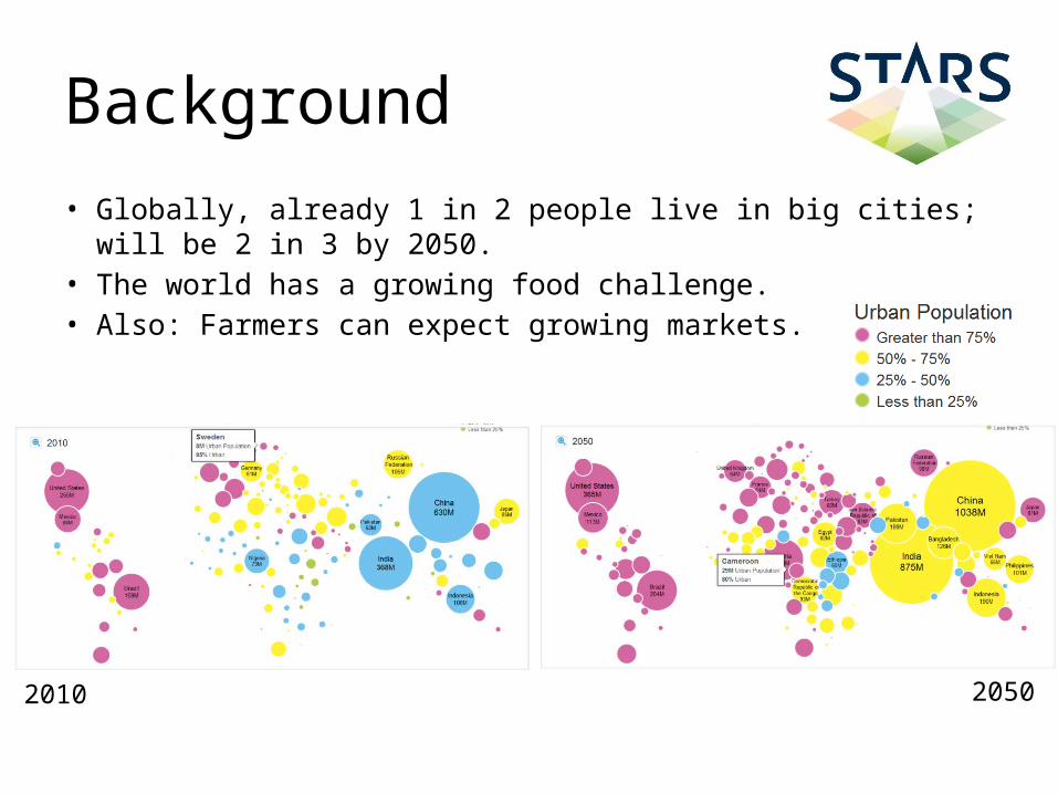
• Globally, already 1 in 2 people live in big cities;will be 2 in 3 by 2050.
• The world has a growing food challenge.• Also: Farmers can expect growing markets.
2010 2050

Background
• Globally, 3 in 4 poor people are rural smallholder farmers.
• Smallholders are not usually included in food production chains, let alone in value chains.
• Africa still has 600 million hectares of unused but arable land; this is 60% of the world’s remaining arable land resources.

STARS characteristics
• Learning grant for five global partners• Demand-driven science: – Which info-products do stakeholders need? – Can we improve the infoconomy around SHA?
• On promise of remote sensing to transform smallholder agriculture
• Intelligent risk taking and making use of the mobile/internet revolution
• Fully equipped with latest technology(cost is not a factor … at first)

Main hypotheses
We think we can • monitor crop growth within the small farms of sub-
Saharan Africa and Southern Asia, using time-series remote sensing.
If achievable, this will • allow better estimates of crop yields throughout the
season, informing policy-makers, and • ensure more effective evidence-based advisory services
at the farm scale, informing farmers and agro-business.

Three facets
Technology
Business
Stakeholder
sustainable modelsof realization
information productsthat inform & transform
agricultural processes
ground-based, airborne,and spaceborne monitoringthroughout the crop season

Where we will work
bottom-up top-down mid-levelStakeholder approaches:

W African value propositions

Potential RS-based info-products
• National yield forecasts• District farm community performance• Comparative farm performance• Crop insurance and farm microfinance• Farm management advisories• Farm risks from climate and market instabilities• Retail value chain advisories• Crop certification for consumers

Project facts• Five partners: ITC, CSIRO, ICRISAT, University of
Maryland, CIMMYT• 20 months = 1 or 2 crop seasons• Budget $ 8.2 million, of which $ 7.5 million as BMGF
grant• Supported by DigitalGlobe & RapidEye data &
knowledge contracts, and Esri sw contract• Started June 1, 2014• Various subgrants/-contracts: Uni Sokoine, ESIPPS,
Manobi, CEGIS, …• Links with other BMGF initiatives: VitalSigns, AfSIS, CIP,
and some health projects

Cutting edge technologygr
ound
air
spac
e

Public good outcomes
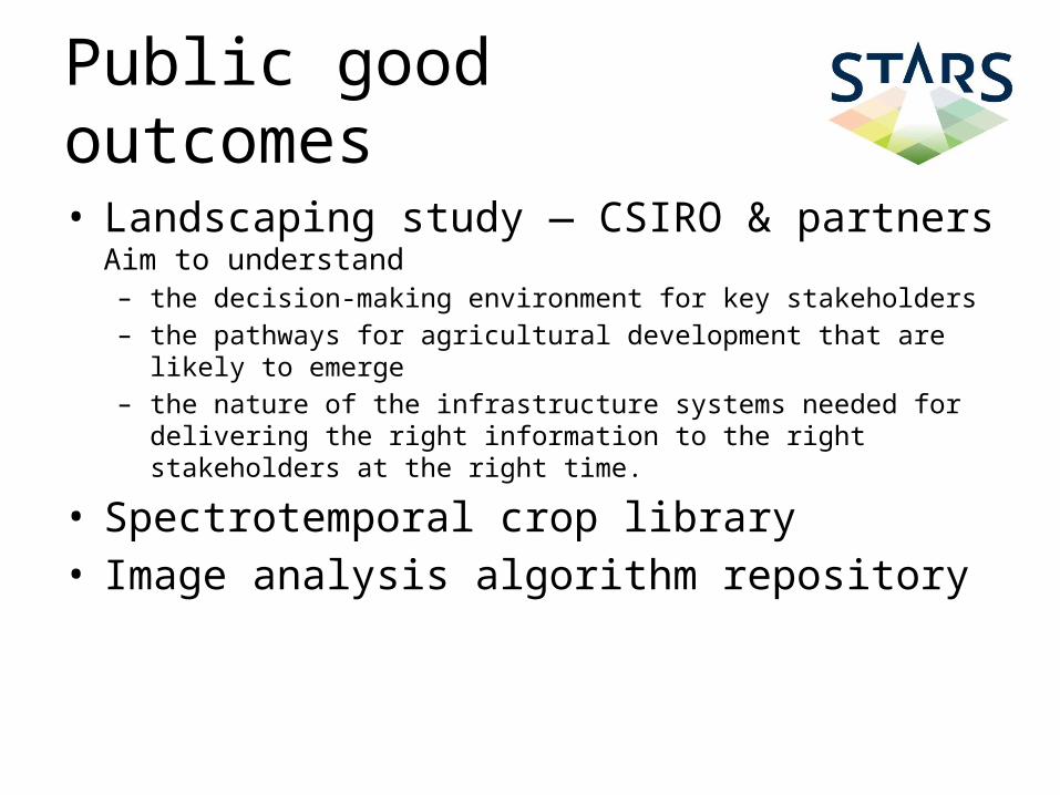
• Landscaping study — CSIRO & partnersAim to understand– the decision-making environment for key stakeholders– the pathways for agricultural development that are likely to emerge– the nature of the infrastructure systems needed for delivering the right
information to the right stakeholders at the right time.
• Spectrotemporal crop library• Image analysis algorithm repository

Outcomes connected with
•
Crop Monitor component for Tanzania developed by UMD (Becker/Dempewolf) under STARS
– STARS field protocols are superset of JECAM’s(UCL/Defourny, UMD/Becker, all teams)
– Sites in Tanzania, Mali, Nigeria will be registered as JECAM sites
• STARS Advocacy efforts– Knowledge portal on RS4SHA


How did we obtain this grant?
• Understanding analogy & differences in mission statements of BMGF and ITC• BMGF-funded project AgCommons 2008-2009• Gradual partnership building with (people at)
– CGIAR: IFPRI, ICRISAT, ILRI, IRRI– SpatialDev
• Going the distance• Advocating ITC strengths & understanding disciplinary complementarity
– Entrepreneurship– African infoconomy & models of information exchange– Understanding Geo-ICT– ITC’s broad expertise base in GIS and RS– Wide alumni base in BMGF target geographies
• Visibility: AfricaGIS, AAGW and Esri UC• Workshop invitations from BMGF• Serendipity• One big learning experience
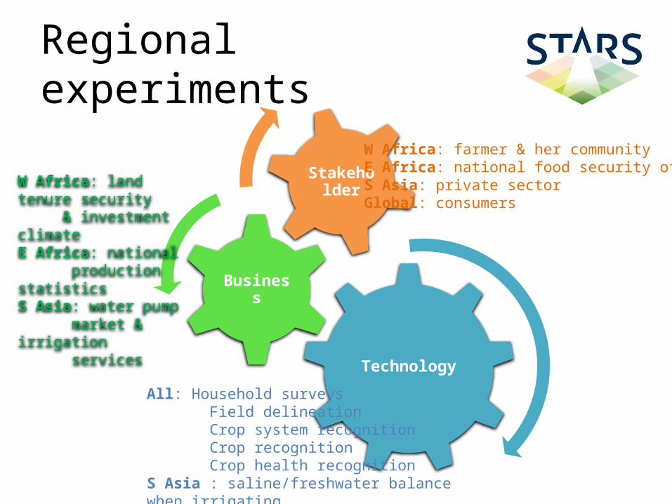
Regional experiments
Technology
Business
StakeholderW Africa: land tenure security & investment climateE Africa: national production statisticsS Asia: water pump market & irrigation services
W Africa: farmer & her communityE Africa: national food security officesS Asia: private sectorGlobal: consumers
All: Household surveys Field delineation Crop system recognition Crop recognition Crop health recognitionS Asia : saline/freshwater balance when irrigating