
Stakeholder Submission Lake Eyre Yacht Club 1. Introduction
25
Lake Eyre Yacht Club Stakeholder Submission - November 2013 1 Stakeholder Submission – Lake Eyre Yacht Club 1. Introduction Boating has been occurring on Lake Eyre for 63 years, perhaps even longer if you consider evidence that the Dieri had boat construction technology. Recent attempts to prevent boating have not been tested in court despite the Club’s efforts to do so. This image could be of people recreating on any seaside beach in Australia. Such activity is a well-recognised part of Australian culture. Yet when it was taken in April 2011, if you believed the then South Australian Premier and Minister for Aboriginal Affairs, these people – swimming, fishing, paddling, building sand castles and boating were breaking the law – simply by recreating within a National Park. The circumstances behind this act of political lunacy would make an interesting book illustrating the political corruption of a government desperate to please a mining company. Particularly when staff of AARD had acknowledged a fortnight before this image was taken that neither Native Title nor Aboriginal Heritage can prevent persons recreating in a National Park. Essentially the Club’s battle has been a political one. In our multicultural society the members of the Lake Eyre Yacht Club have a culture too. Support for our cause is easy to obtain from media, business and ordinary people alike. The members of the Club are willing to continue this battle as it moves into its final stage. Bob Backway, Commodore, Lake Eyre Yacht Club
Transcript of Stakeholder Submission Lake Eyre Yacht Club 1. Introduction

Lake Eyre Yacht Club Stakeholder Submission - November 2013
1
Stakeholder Submission – Lake Eyre Yacht Club
1. Introduction
Boating has been occurring on Lake Eyre for 63 years, perhaps even longer if you
consider evidence that the Dieri had boat construction technology. Recent attempts
to prevent boating have not been tested in court despite the Club’s efforts to do so.
This image could be of people recreating on any seaside beach in Australia. Such
activity is a well-recognised part of Australian culture. Yet when it was taken in April
2011, if you believed the then South Australian Premier and Minister for Aboriginal
Affairs, these people – swimming, fishing, paddling, building sand castles and
boating were breaking the law – simply by recreating within a National Park. The
circumstances behind this act of political lunacy would make an interesting book
illustrating the political corruption of a government desperate to please a mining
company. Particularly when staff of AARD had acknowledged a fortnight before this
image was taken that neither Native Title nor Aboriginal Heritage can prevent
persons recreating in a National Park.
Essentially the Club’s battle has been a political one. In our multicultural society the
members of the Lake Eyre Yacht Club have a culture too. Support for our cause is
easy to obtain from media, business and ordinary people alike. The members of the
Club are willing to continue this battle as it moves into its final stage.
Bob Backway, Commodore, Lake Eyre Yacht Club

Lake Eyre Yacht Club Stakeholder Submission - November 2013
2
2. The Club’s aims from this point on
1. Recognition of the right to boat as a normal recreational activity in Lake Eyre
National Park as it is in all other parks.
2. Agreement that all rules apply to all. No specific boating rules, permits or fees.
3. Any restrictions on boating areas be purely on environmental grounds – such
as bird nesting and feeding sites - but only as observed at that particular flood,
this being a dynamic situation. These restrictions apply to all activities and park
users.
4. The observation that there are no physical aboriginal significant sites within the
Lake but agreement to mutual respect for all stakeholders cultural attachment
to the lake and a guarantee that physical heritage, regardless of culture will be
protected.
5. Restore access to Lake Eyre South as a public access road with camping so
that people may directly access a firm beach and enjoy a sunset over the lake.
The Club is willing to canvas support and funding to facilitate this aim.
6. Formally register our disappointment that native title over the entire Lake and a
substantial area to its south has been given to the Arabunna when there is
substantial evidence that five groups abutted the lake and each group "owned"
its side only. We particularly feel that our friends the Dieri have been unjustly
treated and the area to the south of Lake Eyre should have been designated
“neutral” territory as no existing group can have an exclusive claim to it.
Lake Eyre Yacht Club Stakeholder Submission - November 2013
3
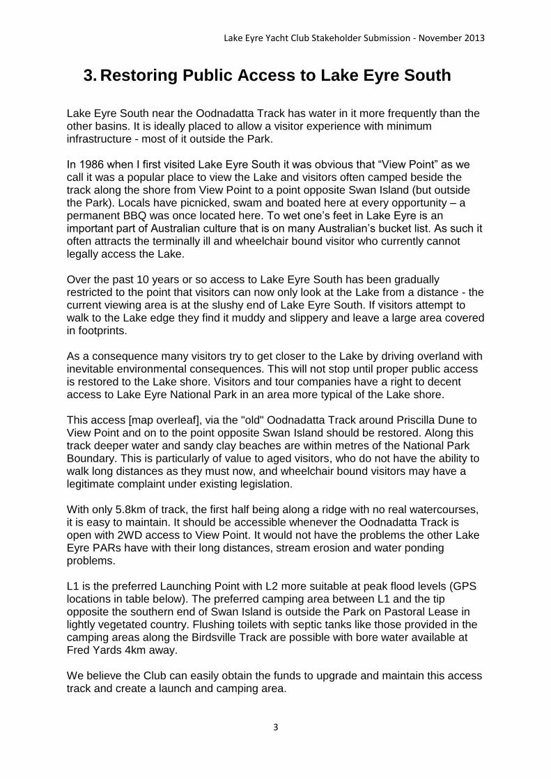
3. Restoring Public Access to Lake Eyre South
Lake Eyre South near the Oodnadatta Track has water in it more frequently than the other basins. It is ideally placed to allow a visitor experience with minimum infrastructure - most of it outside the Park. In 1986 when I first visited Lake Eyre South it was obvious that “View Point” as we call it was a popular place to view the Lake and visitors often camped beside the track along the shore from View Point to a point opposite Swan Island (but outside the Park). Locals have picnicked, swam and boated here at every opportunity – a permanent BBQ was once located here. To wet one’s feet in Lake Eyre is an important part of Australian culture that is on many Australian’s bucket list. As such it often attracts the terminally ill and wheelchair bound visitor who currently cannot legally access the Lake. Over the past 10 years or so access to Lake Eyre South has been gradually restricted to the point that visitors can now only look at the Lake from a distance - the current viewing area is at the slushy end of Lake Eyre South. If visitors attempt to walk to the Lake edge they find it muddy and slippery and leave a large area covered in footprints. As a consequence many visitors try to get closer to the Lake by driving overland with inevitable environmental consequences. This will not stop until proper public access is restored to the Lake shore. Visitors and tour companies have a right to decent access to Lake Eyre National Park in an area more typical of the Lake shore. This access [map overleaf], via the "old" Oodnadatta Track around Priscilla Dune to View Point and on to the point opposite Swan Island should be restored. Along this track deeper water and sandy clay beaches are within metres of the National Park Boundary. This is particularly of value to aged visitors, who do not have the ability to walk long distances as they must now, and wheelchair bound visitors may have a legitimate complaint under existing legislation. With only 5.8km of track, the first half being along a ridge with no real watercourses, it is easy to maintain. It should be accessible whenever the Oodnadatta Track is open with 2WD access to View Point. It would not have the problems the other Lake Eyre PARs have with their long distances, stream erosion and water ponding problems. L1 is the preferred Launching Point with L2 more suitable at peak flood levels (GPS locations in table below). The preferred camping area between L1 and the tip opposite the southern end of Swan Island is outside the Park on Pastoral Lease in lightly vegetated country. Flushing toilets with septic tanks like those provided in the camping areas along the Birdsville Track are possible with bore water available at Fred Yards 4km away. We believe the Club can easily obtain the funds to upgrade and maintain this access track and create a launch and camping area.
Lake Eyre Yacht Club Stakeholder Submission - November 2013
4
Detail of proposed LES viewing and camping area
Lake Eyre Yacht Club Stakeholder Submission - November 2013
5
Further detail for this proposal should wait till agreement in principle is obtained.
However:
We would like to see any infrastructure minimised, low profile and
inconspicuous, including fencing even though it would be outside the National
Park boundary.
The launching “ramp” ideally to be a 6m wide strip from the inland side of the
lake edge dune to the lake floor. It is the only infrastructure within the National
Park.
It will lower environmental impact if the launching ramp was of the chained
timber variety. This would help define the approved area and would have the
dual role of providing wheel chair access.
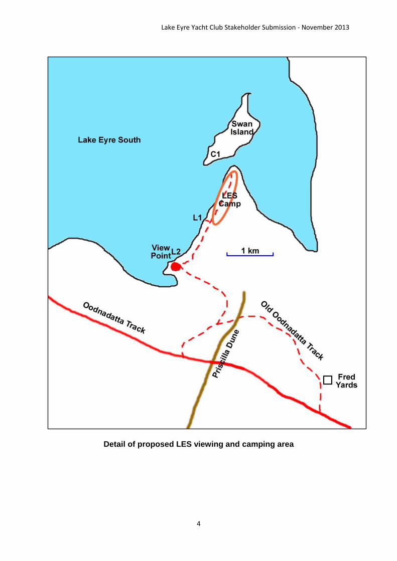
View Point is easily identifiable as the knobby hill close to the edge of the Lake. Hence the best view is obtained from here.
The view from View Point (1997)
The current Launching Area at L1 is
identified by the Stuart Creek “keep out” sign
placed in front of my vehicle in September
2010.
Lake Eyre Yacht Club Stakeholder Submission - November 2013
6
4. Boating on Lake Eyre – Infrequency of Opportunity
When considering the environmental impact of boating on Lake Eyre and associated
dispersed camping on its shores weight must be given to the fact that these
recreational activities are only possible for short periods of time at intervals of years,
sometimes generations, apart. In fact a problem “regular” boating users have is that
whole regime changes occur in park management and adjacent pastoral lease
ownership between flood events. Additionally the short duration of many flood events
makes taking advantage of a boating opportunity difficult for most working people as
leave is rarely available with two weeks’ notice.
From 1974-1978 the Lake was “full”, peaking at 6m and dropping to 2m in 1978,
boating was common place in most areas for this period. This was considered an
exceptional flood event (6m) with floods `almost as high having an interval of 25 – 35
years such as in 1890, 1920 and 1950 (5m). From 1979 when satellite technology
allowed remote depth monitoring more accurate figures are available.
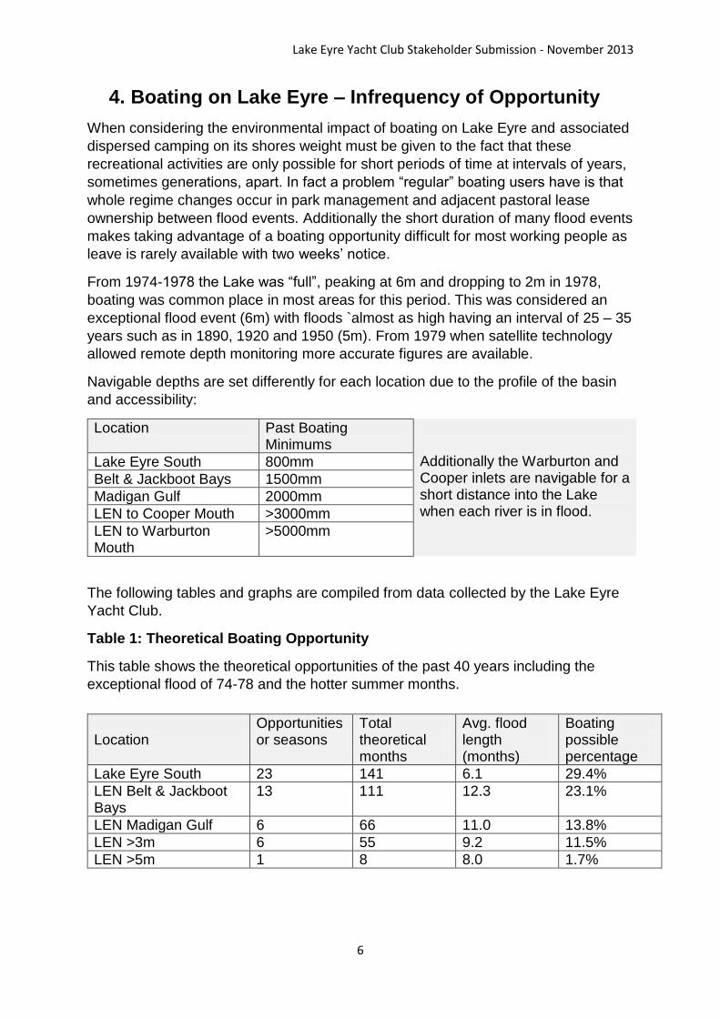
Navigable depths are set differently for each location due to the profile of the basin
and accessibility:
Location
Past Boating Minimums
Additionally the Warburton and Cooper inlets are navigable for a short distance into the Lake when each river is in flood.
Lake Eyre South 800mm
Belt & Jackboot Bays 1500mm
Madigan Gulf 2000mm
LEN to Cooper Mouth >3000mm
LEN to Warburton Mouth
>5000mm
The following tables and graphs are compiled from data collected by the Lake Eyre
Yacht Club.
Table 1: Theoretical Boating Opportunity
This table shows the theoretical opportunities of the past 40 years including the
exceptional flood of 74-78 and the hotter summer months.
Location
Opportunities or seasons
Total theoretical months
Avg. flood length (months)
Boating possible percentage
Lake Eyre South 23 141 6.1 29.4%
LEN Belt & Jackboot Bays
13 111 12.3 23.1%
LEN Madigan Gulf 6 66 11.0 13.8%
LEN >3m 6 55 9.2 11.5%
LEN >5m 1 8 8.0 1.7%
Lake Eyre Yacht Club Stakeholder Submission - November 2013
7
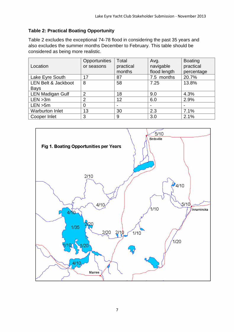
Table 2: Practical Boating Opportunity
Table 2 excludes the exceptional 74-78 flood in considering the past 35 years and
also excludes the summer months December to February. This table should be
considered as being more realistic.
Location
Opportunities or seasons
Total practical months
Avg. navigable flood length
Boating practical percentage
Lake Eyre South 17 87 7.5 months 20.7%
LEN Belt & Jackboot Bays
8 58 7.25 13.8%
LEN Madigan Gulf 2 18 9.0 4.3%
LEN >3m 2 12 6.0 2.9%
LEN >5m 0 - - -
Warburton Inlet 13 30 2.3 7.1%
Cooper Inlet 3 9 3.0 2.1%
Lake Eyre Yacht Club Stakeholder Submission - November 2013
8
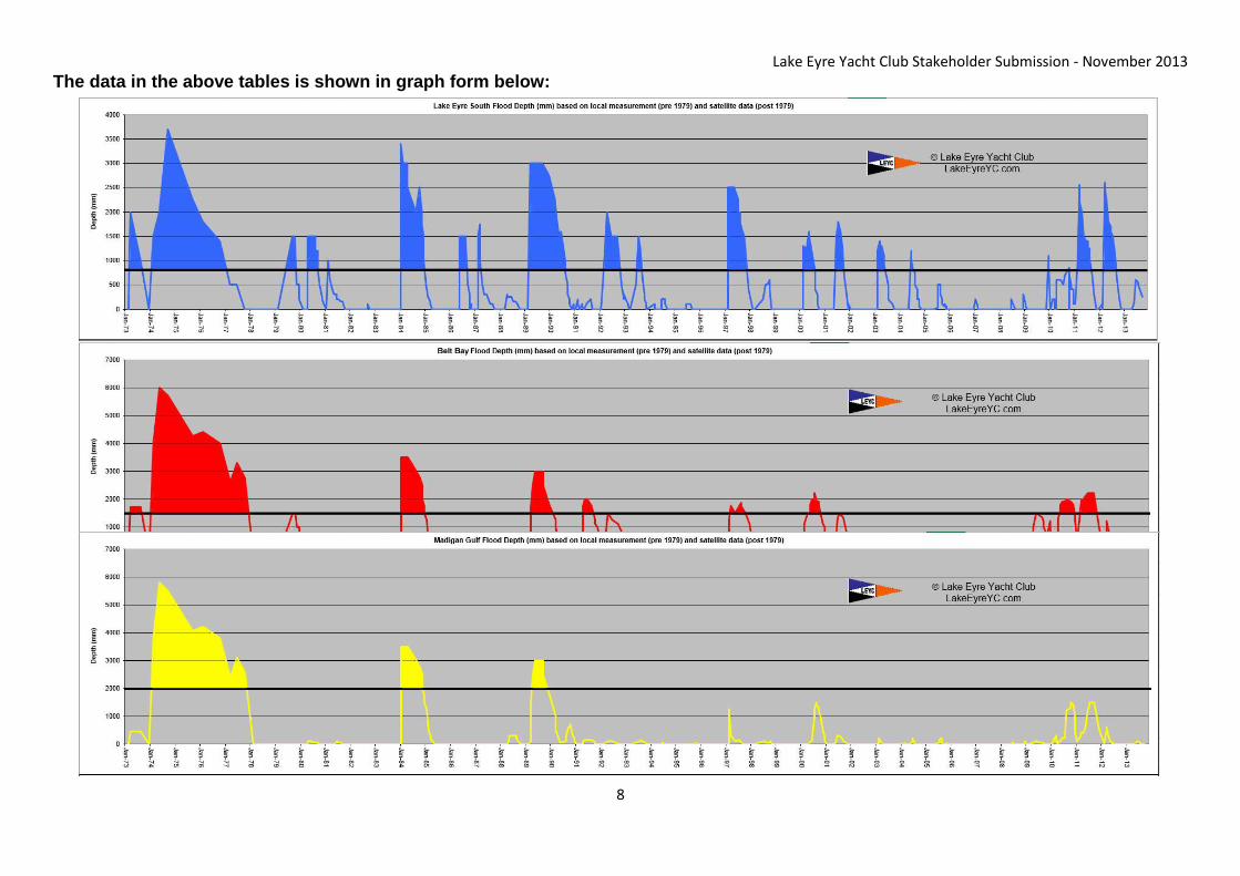
The data in the above tables is shown in graph form below:
Lake Eyre Yacht Club Stakeholder Submission - November 2013
9
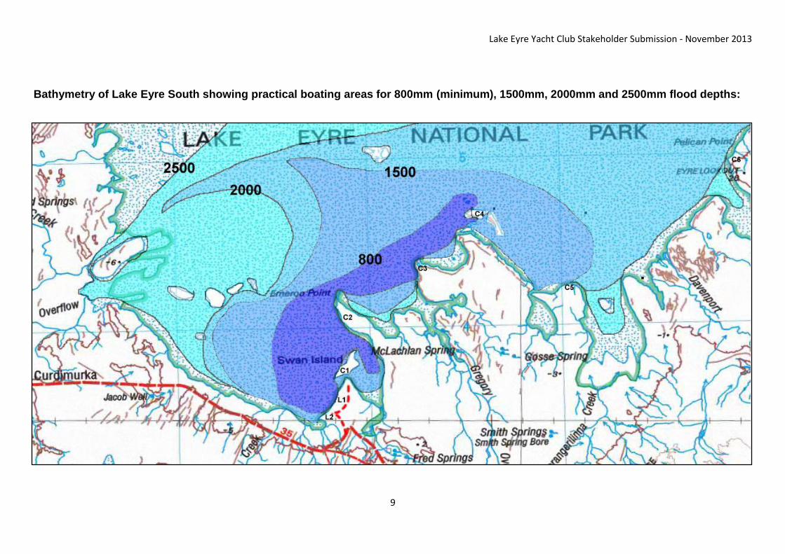
Bathymetry of Lake Eyre South showing practical boating areas for 800mm (minimum), 1500mm, 2000mm and 2500mm flood depths:

Lake Eyre Yacht Club Stakeholder Submission - November 2013
10
Bathymetry of
Belt/Jackboot
Bays showing
practical
boating areas
for 1500mm,
2000mm and
2500mm flood
depths.

Lake Eyre Yacht Club Stakeholder Submission - November 2013
11
5. Known Launch Sites
Lake Eyre North
LENL1 - North West Head (AKA Haligan Point) was used by William Creek Hotel
pilots and others in 1997 and 2000 and the Lake Eyre Yacht Club in 2011. The Lake
has to be over 2m deep to make launching practical here (PAR).
LENL2 - Dingo Soak (via Prominent Hill) was used by LEYC in April and September
2000 and others in 2010. It has a firm sandy clay beach and allows launching if LEN
is above 1.8m. Permission was obtained from Anna Creek Station in 2000 but the
area appears to be now part of Stuart Creek (BHP).
LENL3 - Bonython Headland was used by unknown individuals in 2009 & 2010 by
arrangement with Muloorina Station. It gives good launching at levels down to 1.2m
but is a full day’s drive in. Again this area is now part of Stuart Creek (BHP).
LENL4 - The southern headland of Boundary Bay (the heel of Jackboot Bay) - was
investigated in 2009 by arrangement with Muloorina station as a possible regatta
launch site. The Dulhunty’s launched in the area in 1973 on a 1.8m flood using the
Boundary Bay track. The beach was hard sandy clay and did not leave a footprint.
Unfortunately that year the flood peak was 1.5m and the water there was too
shallow. Also now part of Stuart Creek (BHP).
LENL5 - Level Post Bay (Madigan Gulf) - All boats on the 1950 and 1974 – 77 floods
launched at as this site, including the Hartley 16 Association regatta in 1976, as it
was the only available access to Lake Eyre North at that time. Boats also launched
here in the 1984 and 1989 floods. The current walkway from the car park to the Lake
started life as a launching ramp and features in numerous photographs. Boats have
also been launched towards the mouth of the Goyder Channel from here as the area
from the Goyder Channel mouth to Level Post Bay has been used as a camping
area during every major flood (PAR and Muloorina Station).
Lake Eyre North Launch Sites:
Launch Site Lat/Lon Depth Landing Possible
Attributes
LENL1 North West Head 28 45.905S 136 56.283E
>2000mm Ease of access
LENL2 Dingo Soak 29 00.535S 137 05.365E
>1800mm Low flood access
LENL3 Bonython Headland
28 53.066S 137 06.843E
>1000mm Wide area of choice S from this point
LENL4 Boundary Bay 28 59.498S 137 20.456E
>1500mm Hard Beach
LENL5 Level Post Bay 28 58.999S 137 44.149E
>2000mm Deep water, ease of access
Lake Eyre Yacht Club Stakeholder Submission - November 2013
12
Lake Eyre South
The area from “View Point” to the point opposite Swan Island’s southern tip has been
used in every flood since at least 1974. In 1984 and 1989 a number of people
launched here as it became a popular camping and picnic spot for tourists and locals
alike. A proposal for the return of this area to the public is discussed earlier in this
document (Stuart Creek).
Lake Eyre South Launch Sites:
Launch Site Lat/Lon Depth Launch Possible
Attributes
LESL1 Midway View Point and Swan Island
29 29.334S 137 15.003E
>800mm Deep water 20m from Park Boundary
LESL2 View Point 29 29.834S 137 14.600E
>1000mm Deep water 20m from Park Boundary
Lake Eyre Yacht Club Stakeholder Submission - November 2013
13
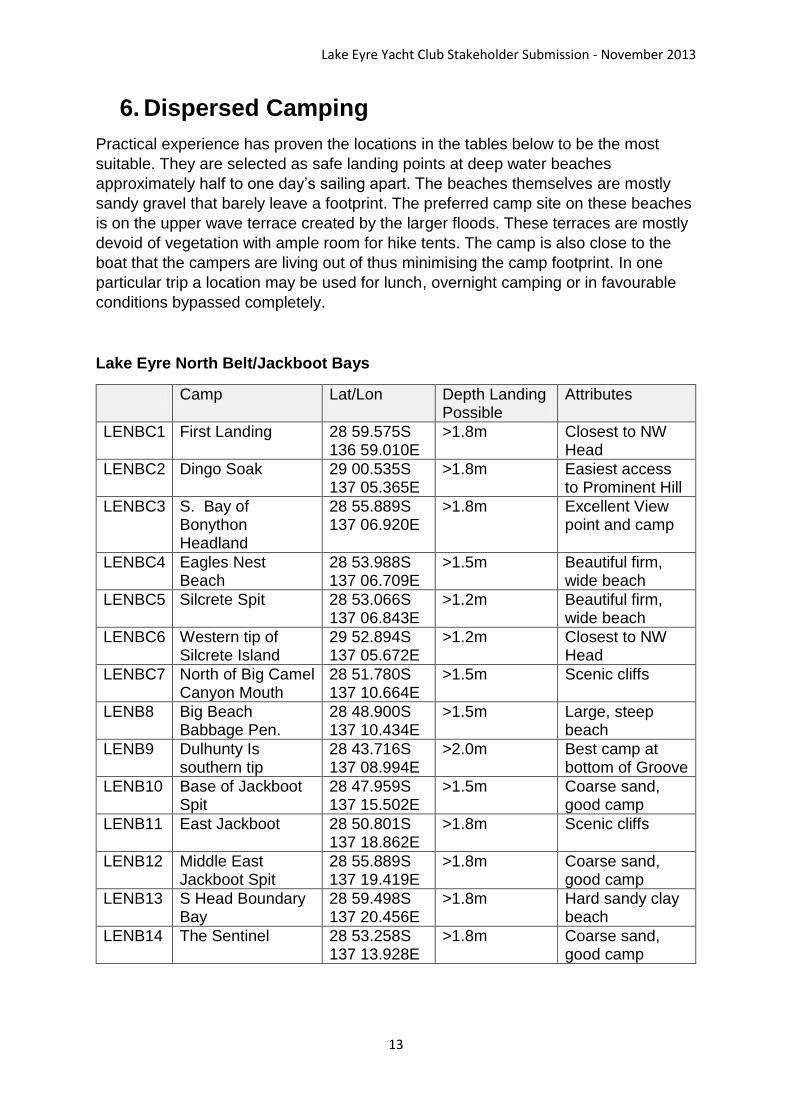
6. Dispersed Camping
Practical experience has proven the locations in the tables below to be the most
suitable. They are selected as safe landing points at deep water beaches
approximately half to one day’s sailing apart. The beaches themselves are mostly
sandy gravel that barely leave a footprint. The preferred camp site on these beaches
is on the upper wave terrace created by the larger floods. These terraces are mostly
devoid of vegetation with ample room for hike tents. The camp is also close to the
boat that the campers are living out of thus minimising the camp footprint. In one
particular trip a location may be used for lunch, overnight camping or in favourable
conditions bypassed completely.
Lake Eyre North Belt/Jackboot Bays
Camp Lat/Lon Depth Landing Possible
Attributes
LENBC1 First Landing 28 59.575S 136 59.010E
>1.8m Closest to NW Head
LENBC2 Dingo Soak 29 00.535S 137 05.365E
>1.8m Easiest access to Prominent Hill
LENBC3 S. Bay of Bonython Headland
28 55.889S 137 06.920E
>1.8m Excellent View point and camp
LENBC4 Eagles Nest Beach
28 53.988S 137 06.709E
>1.5m Beautiful firm, wide beach
LENBC5 Silcrete Spit 28 53.066S 137 06.843E
>1.2m Beautiful firm, wide beach
LENBC6 Western tip of Silcrete Island
29 52.894S 137 05.672E
>1.2m Closest to NW Head
LENBC7 North of Big Camel Canyon Mouth
28 51.780S 137 10.664E
>1.5m Scenic cliffs
LENB8 Big Beach Babbage Pen.
28 48.900S 137 10.434E
>1.5m Large, steep beach
LENB9 Dulhunty Is southern tip
28 43.716S 137 08.994E
>2.0m Best camp at bottom of Groove
LENB10 Base of Jackboot Spit
28 47.959S 137 15.502E
>1.5m Coarse sand, good camp
LENB11 East Jackboot 28 50.801S 137 18.862E
>1.8m Scenic cliffs
LENB12 Middle East Jackboot Spit
28 55.889S 137 19.419E
>1.8m Coarse sand, good camp
LENB13 S Head Boundary Bay
28 59.498S 137 20.456E
>1.8m Hard sandy clay beach
LENB14 The Sentinel 28 53.258S 137 13.928E
>1.8m Coarse sand, good camp
Lake Eyre Yacht Club Stakeholder Submission - November 2013
14
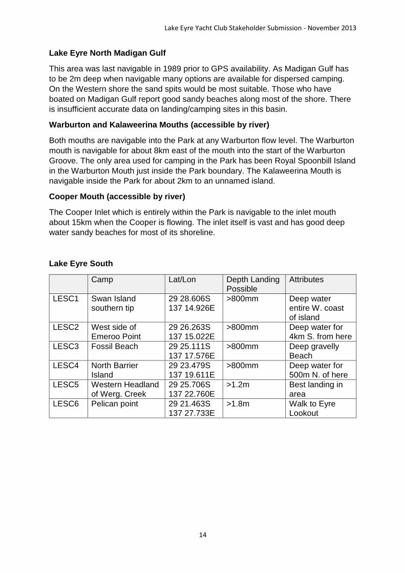
Lake Eyre North Madigan Gulf
This area was last navigable in 1989 prior to GPS availability. As Madigan Gulf has
to be 2m deep when navigable many options are available for dispersed camping.
On the Western shore the sand spits would be most suitable. Those who have
boated on Madigan Gulf report good sandy beaches along most of the shore. There
is insufficient accurate data on landing/camping sites in this basin.
Warburton and Kalaweerina Mouths (accessible by river)
Both mouths are navigable into the Park at any Warburton flow level. The Warburton
mouth is navigable for about 8km east of the mouth into the start of the Warburton
Groove. The only area used for camping in the Park has been Royal Spoonbill Island
in the Warburton Mouth just inside the Park boundary. The Kalaweerina Mouth is
navigable inside the Park for about 2km to an unnamed island.
Cooper Mouth (accessible by river)
The Cooper Inlet which is entirely within the Park is navigable to the inlet mouth
about 15km when the Cooper is flowing. The inlet itself is vast and has good deep
water sandy beaches for most of its shoreline.
Lake Eyre South
Camp Lat/Lon Depth Landing Possible
Attributes
LESC1 Swan Island southern tip
29 28.606S 137 14.926E
>800mm Deep water entire W. coast of island
LESC2 West side of Emeroo Point
29 26.263S 137 15.022E
>800mm Deep water for 4km S. from here
LESC3 Fossil Beach 29 25.111S 137 17.576E
>800mm Deep gravelly Beach
LESC4 North Barrier Island
29 23.479S 137 19.611E
>800mm Deep water for 500m N. of here
LESC5 Western Headland of Werg. Creek
29 25.706S 137 22.760E
>1.2m Best landing in area
LESC6 Pelican point 29 21.463S 137 27.733E
>1.8m Walk to Eyre Lookout

Lake Eyre Yacht Club Stakeholder Submission - November 2013
15
7. Minimum Impact Camping
The publication:
A Handbook for Managers and Recreational Users Department for Environment and Heritage South Australian Association of Four Wheel Drive Clubs
Adequately covers dispersed camping within the Park with reinforcement of the
following points:
Toilet waste and paper to be buried behind lake edge dune where possible
(but not within 100m of fresh water lakes) at least 300mm deep and covered
by compacted sand to minimise possibility of dingos digging waste up. In most
cases this is outside the park boundary.
No burning of toilet paper or burning rubbish to minimise volume as all fires
are prohibited in park.
All rubbish placed in strong bag and removed from park and properly
disposed of in nearby town dumps.
Maximum stay 48 hours at any location unless prevented by bad weather or
stranded by tide.
Small hike tents/swags only and placed on beach terrace. Beach terraces are
usually level, flat and sparsely vegetated gravel surfaces.
All gear to be secularly stowed at all times as southerly busters can arrive at
any time (but mostly in the evening). This prevents accidental littering.
Check site when leaving to ensure no evidence left of occupation.
Fossil Beach LES 1997 – an ideal camp from a boating and a minimum impact
camping perspective.

Lake Eyre Yacht Club Stakeholder Submission - November 2013
16
8. Boating Guidelines
The membership of the Lake Eyre Yacht Club ranges from practical to extreme
conservationist. The recreational activity itself relies heavily on the environment we
sail in and we vigorously encourage the preservation of this environment.
Lake Eyre is vast, the largest inland waterway by far in this country. This inland sea
attracts sea birds, most of which coexist with humans and boats in their alternative
coastal habitats. With the following recommendations the interaction between boats
and birds should be minimal.
Environmental recommendations:
Landing on rookeries prohibited (and this should apply to ALL staff and
visitors to the Park)
Avoid groups of feeding birds on water. If navigation restrictions make it
necessary to approach feeding birds the maximum speed is 2 knots.
Wading birds such as avocets and stilts feed in water too shallow for boating
and so are not disturbed.
Do not feed any wildlife or leave food where wildlife can access it.
Safety
We find it amusing that other players in this battle mention their concern over our
safety. Of the many recreational activities that occur in National parks boating is the
only one that has legislated safety regulations.
For the uninformed, boating safety is legislated as the responsibility of the
Department of Transport under the Marine Harbors and Navigation Act. Lake Eyre is
designated as “Smooth Waters” viz:
Harbors and Navigation Regulations 2009
under the Harbors and Navigation Act 1993
Schedule 1—Smooth and partially smooth waters Part 1—Smooth waters
Area Smooth water limits
[Other areas deleted for brevity]
Lakes and rivers in the Coopers Creek, Lake Eyre, Lakes Frome, Lake Gairdner, Lake Torrens North of South Australia
Other inland areas: All other inland waters except waters designated by this Schedule as partially smooth.
Note that with the “Federalising” of boating safety smooth waters are now referred to
as “Protected Waters” – the word protected meaning “sheltered” and is not used in
the sense that DENWR would use the word.
Lake Eyre Yacht Club Stakeholder Submission - November 2013
17
Minimum Safety Equipment
All vessels operating in South Australian waters are required by law to carry certain
items of safety equipment. Minimum safety equipment requirements for all types of
vessel are shown in Schedule 9 of the Harbors and Navigation Regulations 2009.
The latest version of the Regulations may be viewed by visiting:
www.legislation.sa.gov.au and following the links to ‘Regulations and Rules’ go to
"H', then from the Alphabetical List select Harbors and Navigation Regulations 2009.
Minimum safety equipment requirements vary according to the size and type of boat,
whether it has an engine and where it is being used. Areas where a boat may be
used are defined as protected waters, semi protected waters and unprotected
waters.
Protected Waters – all inland waters, excluding Lakes Albert and Alexandrina ……
Exemptions - The safety equipment requirements apply to the majority of boats.
However, certain types of boat are either partially or totally exempt from these
requirements. Some of the more common exemptions are summarised below. A
surfboard, surf ski or racing shell is exempt from the safety equipment requirements
listed, however, if using a surfboard, surf ski or similar vessel in protected waters,
each occupant must wear a Personal Flotation Device (PFD). Waterskiers (or
persons being towed in any other manner) must wear a PFD Type 2 or 3 at all times
when engaged in waterskiing.
For canoes, kayaks and similar small, unpowered boats the safety equipment
carriage requirements are:
• a PFD that complies with one or more of the appropriate standards for the area of
use (that is: protected, semi-protected, or unprotected waters) and is worn at all
times
• suitable bailer (unless the hull is permanently enclosed)
• a waterproof torch or lantern (while the vessel is being operated during the hours of
darkness).A sailboard rider or kite surfer must at all times wear an approved PFD
that complies with the area of use.
For tender vessels, while being used in conjunction with another vessel, the
requirements are:
• a pair of paddles or oars, or other means of auxiliary propulsion
• a bucket, bailer or bilge pump/s to drain each compartment of the boat
• if the vessel is 1500 metres or more from the shoreline: – before 1 June 2010, a
PFD Type 1, 2 or 3 for each person onboard – on or after 1 June 2010, a PFD Type
1 for each person onboard.
For surf rescue boats propelled by paddles or oars, the vessel must be equipped
with a suitable bailer that is attached to the vessel by a lanyard.
Lake Eyre Yacht Club Stakeholder Submission - November 2013
18
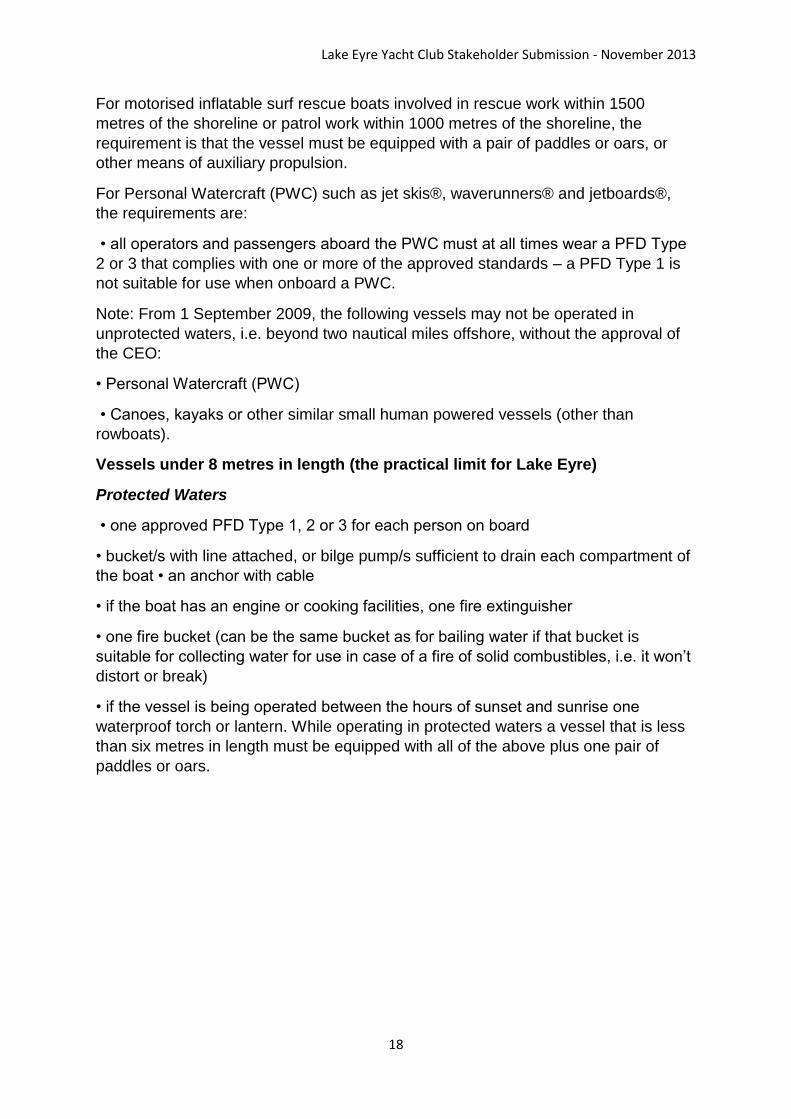
For motorised inflatable surf rescue boats involved in rescue work within 1500
metres of the shoreline or patrol work within 1000 metres of the shoreline, the
requirement is that the vessel must be equipped with a pair of paddles or oars, or
other means of auxiliary propulsion.
For Personal Watercraft (PWC) such as jet skis®, waverunners® and jetboards®,
the requirements are:
• all operators and passengers aboard the PWC must at all times wear a PFD Type
2 or 3 that complies with one or more of the approved standards – a PFD Type 1 is
not suitable for use when onboard a PWC.
Note: From 1 September 2009, the following vessels may not be operated in
unprotected waters, i.e. beyond two nautical miles offshore, without the approval of
the CEO:
• Personal Watercraft (PWC)
• Canoes, kayaks or other similar small human powered vessels (other than
rowboats).
Vessels under 8 metres in length (the practical limit for Lake Eyre)
Protected Waters
• one approved PFD Type 1, 2 or 3 for each person on board
• bucket/s with line attached, or bilge pump/s sufficient to drain each compartment of
the boat • an anchor with cable
• if the boat has an engine or cooking facilities, one fire extinguisher
• one fire bucket (can be the same bucket as for bailing water if that bucket is
suitable for collecting water for use in case of a fire of solid combustibles, i.e. it won’t
distort or break)
• if the vessel is being operated between the hours of sunset and sunrise one
waterproof torch or lantern. While operating in protected waters a vessel that is less
than six metres in length must be equipped with all of the above plus one pair of
paddles or oars.
Lake Eyre Yacht Club Stakeholder Submission - November 2013
19
9. Boating on Lake Eyre - Two Categories
Boating safety is dependent on distance from launch point. This generally falls into
two categories:
Day Boating
Most visitors would probably fit in this category. They don’t have time or the
experience for a long trip and are happy just to have said they have “done it”. Day
boating is generally defined as where the operator remains within site of the
launching point and plans to return before sunset. For example if launching at LESL1
the area would be defined as the bay between the Oodnadatta Track shoreline and
Emeroo Point.
The existing boating safety legislation is adequate for day boating purposes.
However the Lake Eyre Yacht Club suggests a waterproof (or waterproof bagged)
UHF radio could prove a valuable accessory.
Overnight Boating
In this category the operator is navigating in waters that can be described as
“remote” and precautions additional to the marine safety requirements, although
legally not mandatory, should be strongly advised.
When overnight adventure boating the Lake Eyre Yacht Club prefers its members to
be carrying within a group:
1. Satellite Communicator - a hybrid between a GPS, a satphone and an EPIRB
OR a satphone (newer devices have GPS)
OR an EPIRB*(also incorporates a GPS)
2. A GPS
3. Waterproof (or waterproof bagged) UHF radio
4. A map of the area they intend boating in.
5. A compass
We also strongly advise the setting up of a private safety and rescue plan.
The Club has guidelines for water, food, camping equipment, clothing and medical.
*Difficulties with EPIRBs
EPIRBS rely on government agencies to detect and arrange rescue. This takes time.
Authorities are also becoming complacent with requests for help such as heard on
the ABC news in 2011:
“Marine Safety have detected an EPIRB distress signal halfway between Birdsville
and Innamincka. They have contacted the owner’s family who have confirmed that
the owner was well equipped with food and water so they are not looking for him until
tomorrow”.
I hope he survived!
Lake Eyre Yacht Club Stakeholder Submission - November 2013
20
An EPIRB is a device of last resort to be used in a life threatening situation. The
more versatile “communicators” have different levels of communication from position
information only, position with detail of the problem or position with emergency detail.
Adventurers are now turning to these private communication systems using
communicators or satphones which provide direct communication with their
appointed “guardians”. These guardians are provided with a plan that includes
appropriate rescue options, maps and contact details. Guardians are normally
chosen for their familiarity with the area.
Another advantage of private communication, search and rescue is that the media
can be excluded. For example in 2004 Jarvis and Kozel, walking out from the
Warburton Groove, were turned into a media circus by the very person who told
them it was possible to boat it.
Lake Eyre Yacht Club Stakeholder Submission - November 2013
21
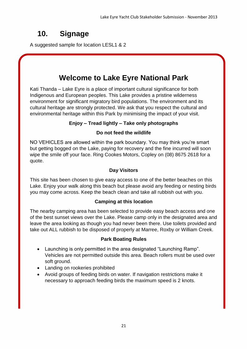
10. Signage
A suggested sample for location LESL1 & 2
Welcome to Lake Eyre National Park
Kati Thanda – Lake Eyre is a place of important cultural significance for both
Indigenous and European peoples. This Lake provides a pristine wilderness
environment for significant migratory bird populations. The environment and its
cultural heritage are strongly protected. We ask that you respect the cultural and
environmental heritage within this Park by minimising the impact of your visit.
Enjoy – Tread lightly – Take only photographs
Do not feed the wildlife
NO VEHICLES are allowed within the park boundary. You may think you’re smart
but getting bogged on the Lake, paying for recovery and the fine incurred will soon
wipe the smile off your face. Ring Cookes Motors, Copley on (08) 8675 2618 for a
quote.
Day Visitors
This site has been chosen to give easy access to one of the better beaches on this
Lake. Enjoy your walk along this beach but please avoid any feeding or nesting birds
you may come across. Keep the beach clean and take all rubbish out with you.
Camping at this location
The nearby camping area has been selected to provide easy beach access and one
of the best sunset views over the Lake. Please camp only in the designated area and
leave the area looking as though you had never been there. Use toilets provided and
take out ALL rubbish to be disposed of properly at Marree, Roxby or William Creek.
Park Boating Rules
Launching is only permitted in the area designated “Launching Ramp”.
Vehicles are not permitted outside this area. Beach rollers must be used over
soft ground.
Landing on rookeries prohibited
Avoid groups of feeding birds on water. If navigation restrictions make it
necessary to approach feeding birds the maximum speed is 2 knots.
Lake Eyre Yacht Club Stakeholder Submission - November 2013
22
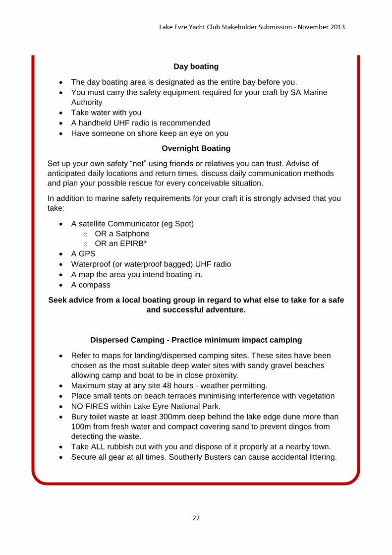
Day boating
The day boating area is designated as the entire bay before you.
You must carry the safety equipment required for your craft by SA Marine
Authority
Take water with you
A handheld UHF radio is recommended
Have someone on shore keep an eye on you
Overnight Boating
Set up your own safety “net” using friends or relatives you can trust. Advise of
anticipated daily locations and return times, discuss daily communication methods
and plan your possible rescue for every conceivable situation.
In addition to marine safety requirements for your craft it is strongly advised that you
take:
A satellite Communicator (eg Spot)
o OR a Satphone
o OR an EPIRB*
A GPS
Waterproof (or waterproof bagged) UHF radio
A map the area you intend boating in.
A compass
Seek advice from a local boating group in regard to what else to take for a safe
and successful adventure.
Dispersed Camping - Practice minimum impact camping
Refer to maps for landing/dispersed camping sites. These sites have been
chosen as the most suitable deep water sites with sandy gravel beaches
allowing camp and boat to be in close proximity.
Maximum stay at any site 48 hours - weather permitting.
Place small tents on beach terraces minimising interference with vegetation
NO FIRES within Lake Eyre National Park.
Bury toilet waste at least 300mm deep behind the lake edge dune more than
100m from fresh water and compact covering sand to prevent dingos from
detecting the waste.
Take ALL rubbish out with you and dispose of it properly at a nearby town.
Secure all gear at all times. Southerly Busters can cause accidental littering.

Lake Eyre Yacht Club Stakeholder Submission - November 2013
23
11. Access through Pastoral Lease
From time to time access has been granted by leaseholders to Lake Eyre National Park for the purpose of boating. For example:
1. In addition to the William Creek - Lake Eyre North PAR Anna Creek gave permission three times in 2000 for access via the Prominent Hill Track to the Dingo Soak launch point.
2. Negotiations commenced in 2009 with Muloorina but unfortunately LEN was not deep enough.
3. Etadunna have suggested we utilize their access to Clayton Inlet.
4. In 2011 BHP gave approval to access Lake Eyre South conditional on Arabunna approval.
We find we have to renegotiate access for each flood event due to management and ownership changes. For example except for the William Creek PAR all the above access points are now on Leases primarily owned by BHP. BHP, unlike family owned leaseholders, tend to have difficulty understanding their tenure over the land – or try to bluff their way through.
The following extract from the Pastoral Act recognizes that Pastoral Leases are only a licence to graze Crown Land in exchange for certain improvements and care of that land. As Crown Land ordinary Australians have a right to enter and recreate within it. Viz:
48—Right to travel across and camp on pastoral land
(1) Subject to this Act, a person may travel (by any means) or camp temporarily
on a public access route.
(2) Subject to this Act and to the terms (if any) of an ILUA relating to public
access and activities on the land in force in relation to the land, a person
may, on giving oral or written notice to the lessee, travel across pastoral
land (otherwise than on a public access route) by any means other than a
motor vehicle, a horse or a camel and, in the course of so travelling, camp
temporarily on the land.
(2a) A term of an ILUA may only limit a right conferred by subsection (2) to the
extent reasonably necessary for the following purposes:
(a) restricting public access to places identified by the native title group
as being places of cultural significance;
(b) preventing injury, damage or loss to any person that may arise from
an activity undertaken under the ILUA or under section 47(1);
(c) protecting an activity of the native title group on pastoral land the
subject of the ILUA.

Lake Eyre Yacht Club Stakeholder Submission - November 2013
24
(3) Subject to this Act, a person may, with the consent of the lessee or the
Minister, travel across pastoral land (otherwise than on a public access
route) by means of a motor vehicle, a horse or a camel and, in the course
of so travelling, camp temporarily on the land.
(4) This section does not give a person the right to camp—
(a) within a radius of one kilometre of any house, shed or other
outbuilding on the land; or
(b) within a radius of 500 metres of a dam or any other constructed stock
watering point on the land.
(5) A person who proposes to travel across or camp on pastoral land in the
manner referred to in subsection (3) must first seek the lessee's consent
to the proposal and the lessee may refuse that consent if of the opinion
that it is necessary to do so for the purposes of the safety of the public,
the management of stock or the carrying out of rehabilitative work on the
land or for any other good and sufficient reason.
(6) If the lessee refuses to consent to a proposal under subsection (5), the
person may seek the Minister's consent to the proposal.
(7) The Minister may, without consulting the lessee, consent to the proposal but,
if the Minister consents to the proposal without consulting the lessee, the
proposal cannot be carried out until the Minister has notified the lessee
that consent has been given.
(8) The Minister incurs no liability by virtue of giving consent to a proposal to
travel across or camp on pastoral land.
(8a) A lessee must not give consent under subsection (5), or the Minister under
subsection (7), to a proposal to travel across or camp on pastoral land in a
manner referred to in subsection (3) if to do so would be inconsistent with
the terms (if any) of an ILUA in force in relation to the land relating to
public access and activities on the land.
(9) For the purposes of this section, camping is temporary if it is for a period not
exceeding two weeks or, if some other greater or lesser period is
prescribed in respect of a particular area, that period in relation to
camping in that area.
(10) An authorised person may give to a person travelling across or camping on
pastoral land the subject of an ILUA such directions as may be reasonably
required for the purpose of giving effect to a term of an ILUA relating to
one or more of the purposes referred to in subsection (2a).
(11) A person who, without lawful authority or reasonable excuse, fails to comply
with a direction under subsection (10) is guilty of an offence.
Maximum penalty: $1 250.

Lake Eyre Yacht Club Stakeholder Submission - November 2013
25
(12) In this section—
authorised person means—
(a) the lessee of pastoral land the subject of the ILUA; or
(b) the native title group in relation to pastoral land the subject of the
ILUA; or
(c) an employee of the lessee or other person acting on the authority of
the lessee.
(13) In proceedings for an offence against this section, an allegation in the
complaint that a person named in the complaint was on a specified date
an authorised person in relation to specified pastoral land will be
accepted, in the absence of proof to the contrary, as proof of the
authorisation.
As an example of the ability of this Act to protect our access over, and our right to
camp on, Pastoral Lease the Australian Wildlife Conservancy, even after the Club’s
arranging with Channel 7 to promote their cause, engaged a solicitor in an attempt to
prevent us from accessing the Rivers through Kalamurina (which is Crown Land –
Pastoral Lease). They failed.
If BHP decided to block a legitimate request for access to a National Park they would
risk the same type of adverse publicity subjected to other players in this battle for
seeking to prevent an activity that the majority of Australians believe is well within
their rights.


![Deborah Eyre[1]](https://static.fdocuments.net/doc/165x107/55254e884a795953498b4af7/deborah-eyre1.jpg)