Staff Report 12 - .NET Framework
22
1 Meeting Date: 02/23/21 Lease Number: A2702 Staff: M.J. Columbus Staff Report 12 APPLICANT: Sutter Butte Flood Control Agency PROPOSED ACTION: Issuance of General Lease – Dredging Use AREA, LAND TYPE, AND LOCATION: Sovereign land in the Feather River, adjacent to 1100 Pennington Road, near Live Oak, Sutter County. AUTHORIZED USE: Maintenance dredge a maximum of 3,400 cubic yards of sediment and 1.5 acres of invasive water primrose. TERM: 5 years, beginning February 23, 2021. CONSIDERATION: Public use and benefit; with the State reserving the right at any time to set a monetary rent if the Commission finds such action to be in the State’s best interests; dredged material may not be sold. SPECIFIC LEASE PROVISIONS: • In performing dredging operations, the Lessee will abide by Best Management Practices to control turbidity and protect aquatic resources and habitats from excessive siltation in the general vicinity of the Project. • Lessee acknowledges that material dredged from the Lease Premises is the property of the State of California and shall not be sold, and that Lessee is not authorized to dredge for purposes of commercial resale, environmental mitigation credits, or other private benefit without Lessor’s prior written consent.
Transcript of Staff Report 12 - .NET Framework

1
Meeting Date: 02/23/21
Lease Number: A2702
Staff: M.J. Columbus
Staff Report 12
APPLICANT:
Sutter Butte Flood Control Agency
PROPOSED ACTION:
Issuance of General Lease – Dredging Use
AREA, LAND TYPE, AND LOCATION: Sovereign land in the Feather River, adjacent to 1100 Pennington Road, near Live
Oak, Sutter County.
AUTHORIZED USE: Maintenance dredge a maximum of 3,400 cubic yards of sediment and 1.5 acres
of invasive water primrose.
TERM: 5 years, beginning February 23, 2021.
CONSIDERATION: Public use and benefit; with the State reserving the right at any time to set a
monetary rent if the Commission finds such action to be in the State’s best interests;
dredged material may not be sold.
SPECIFIC LEASE PROVISIONS: • In performing dredging operations, the Lessee will abide by Best Management
Practices to control turbidity and protect aquatic resources and habitats from
excessive siltation in the general vicinity of the Project.
• Lessee acknowledges that material dredged from the Lease Premises is the
property of the State of California and shall not be sold, and that Lessee is not
authorized to dredge for purposes of commercial resale, environmental
mitigation credits, or other private benefit without Lessor’s prior written consent.

Staff Report 12 (continued)
2
• Lessee shall coordinate with the U.S. Coast Guard in placing and maintaining
navigational buoys as a warning to boaters at all times during dredging
activities.
STAFF ANALYSIS AND RECOMMENDATION:
AUTHORITY: Public Resources Code sections 6005, 6216, 6301, 6303, 6501.1, and 6503; California
Code of Regulations, title 2, sections 2000 and 2003.
PUBLIC TRUST AND STATE’S BEST INTERESTS: On August 11, 2009, the Commission authorized a 25-year General Lease – Public
Agency Use, No. PRC 8835, to the County of Sutter for the removal of an existing
public boat launching ramp, construction of a new public boat launching ramp
and floating dock with gangway, placement of rock slope protection, construction
and maintenance dredging (30 to 60 cubic yards every 3 years), and the
temporary placement of warning buoys during construction (Item C27, August 11,
2009). That lease will expire on July 13, 2029.
The Applicant has applied for a General Lease – Dredging to remove sediment and
invasive water primrose within and outside of the County of Sutter’s lease area
(Project). The Applicant has consulted with the County of Sutter for the use of the
leased premises for the Project and the County supports the dredging by the Sutter
Butte Flood Control Agency. Sediment has accumulated adjacent to the Live Oak
Recreational Park Boat Ramp facility in the Feather River. The Oroville Dam spillway
failures in 2017 caused further substantial accumulation of sediment deposition. This
has created dangerous conditions for recreational users and has made the boat
launch facilities nearly unusable. Recreational users and public safety have been
negatively impacted and emergency vessel launching capabilities at the boat
ramp have been affected. The Project proposes to facilitate access to the existing
boat ramp and navigational safety. The Project has received funding from the
California Natural Resources Agency through Proposition 68 to remove sediment for
safety and to restore recreation access to the Feather River.
The proposed Project will be performed from the boat ramp and adjacent to the
shoreline by a dredging crane with a digging bucket or flat-cut bucket excavator,
dump trucks, and backhoe. The excavator will not penetrate the vegetation or
riparian areas along the shore and will stay within the riverbank. If any area of the
river is entered with the dredging equipment, sedimentation curtains or wattles will
be used. The material will be disposed of at the Gridley Wastewater Treatment

Staff Report 12 (continued)
3
Plant (WWTP) emergency storage ponds, or at the Ostrom Road and Neil Road
landfills.
Dredging is proposed to take place in the summer of 2021. The dredging would be
limited to June 15 – October 15. The boat ramp will be closed for 1 to 2 weeks
during the dredging. Alternate access to the river is located north of the Project at
the Gridley Boat Launch and to the south at the Yuba City or Marysville Boat
Launches.
The Applicant has permission to use the uplands adjoining the lease premises. The
public boat launching ramp is maintained by the County of Sutter. The proposed
dredging will facilitate recreational boating and improve navigation. Recreational
boating is a water-dependent use that is generally consistent with the common law
Public Trust Doctrine. The California Legislature has identified private recreational
boating facilities as an authorized use of Public Trust land (Pub. Resources Code, §
6503.5).
CLIMATE CHANGE: The project area is not tidally influenced and therefore, would not be subject to
sea-level rise. However, as stated in Safeguarding California Plan: 2018 Update
(California Natural Resources Agency 2018), climate change is projected to
increase the frequency and severity of natural disasters related to flooding,
drought, and storms. In rivers, more frequent and powerful storms can result in
increased flooding conditions and damage from storm-created debris. Conversely,
prolonged droughts could dramatically reduce river flow and water levels, leading
to loss of public access and navigability. Climate change will further influence
riverine areas by changing erosion and sedimentation rates, and flooding and
storm flow, as well as runoff, will likely increase scour, decreasing bank stability at a
faster rate. The proposed Project, together with the periodic maintenance
dredging required by Lease No. 8835 to the County of Sutter, will reduce the
likelihood of severe structural degradation of the boat ramp facility and reduce the
establishment of invasive plants in the future.
CONCLUSION: For all the reasons above, staff believes the issuance of this lease will not
substantially interfere with Public Trust needs at this location, at this time, and for the
foreseeable term of the proposed lease; is consistent with the Public Trust Doctrine;
and is in the best interests of the State.

Staff Report 12 (continued)
4
OTHER PERTINENT INFORMATION:
1. Approval or denial of the application is a discretionary action by the
Commission. Each time the Commission approves or rejects a use of sovereign
land, it exercises legislatively delegated authority and responsibility as trustee of
the State’s Public Trust lands as authorized by law. If the Commission denies the
application, the Applicant will not be authorized to perform maintenance
dredging. Upon expiration or prior termination of the lease, the lessee also has
no right to a new lease or to renewal of any previous lease.
2. This action is consistent with Strategy 1.1 of the Commission’s Strategic Plan to
deliver the highest levels of public health and safety in the protection,
preservation, and responsible economic use of the lands and resources under
the Commission’s jurisdiction, and Strategy 1.3 to promote, expand, and
enhance appropriate public use and access to land along the State’s inland
and coastal waterways.
3. A Mitigated Negative Declaration, State Clearinghouse No. 2020100322, and a
Mitigation Monitoring Program (MMP) were prepared by Sutter Butte Flood
Control Agency and adopted on December 9, 2020, for this project.
Commission staff reviewed these documents and prepared an independent
MMP (attached, Exhibit C) incorporating the Sutter Butte Flood Control Agency’s
document and recommends its adoption by the Commission.
4. This activity involves lands identified as possessing significant environmental
values pursuant to Public Resources Code section 6370 et seq., but the activity
will not affect those significant lands. Based upon staff’s consultation with the
persons nominating such lands and through the California Environmental Quality
Act (CEQA) review process, it is staff’s opinion that the project, as proposed, is
consistent with its use classification.
APPROVALS OBTAINED:
U.S. Army Corps of Engineers
Central Valley Flood Protection Board
APPROVALS REQUIRED:
California Department of Fish and Wildlife
California Department of Transportation
Central Valley Regional Water Quality Control Board

Staff Report 12 (continued)
5
National Marine Fisheries Service
State Water Resources Control Board
Feather River Air Quality Management District
U.S. Fish and Wildlife Service
EXHIBITS:
A. Land Description
B. Site and Location Map
C. Mitigation Monitoring Program
RECOMMENDED ACTION:
It is recommended that the Commission:
CEQA FINDING: Find that a Mitigated Negative Declaration, State Clearinghouse No. 2020100322,
and a Mitigation Monitoring Program were prepared by the Sutter Butte Flood
Control Agency and adopted on December 9, 2020, for this project and that the
Commission has reviewed and considered the information contained therein; that
in the Commission’s independent judgment, the scope of activities to be carried
out under the lease to be issued by this authorization have been adequately
analyzed; that none of the events specified in Public Resources Code section 21166
or the State CEQA Guidelines section 15162 resulting in any new or substantially
more severe significant impacts has occurred; and, therefore no additional CEQA
analysis is required.
Adopt the Mitigation Monitoring Program, as contained in the attached Exhibit C.
SIGNIFICANT LANDS INVENTORY FINDING:
Find that this activity is consistent with the use classification designated by the
Commission for the land pursuant to Public Resources Code section 6370 et seq.
PUBLIC TRUST AND STATE’S BEST INTERESTS: Find that the proposed lease will not substantially impair the public rights to
navigation and fishing or substantially interfere with the Public Trust needs and
values at this location, at this time, and for the foreseeable term of the lease; is
consistent with the Public Trust Doctrine; and is in the best interests of the State.
Staff Report 12 (continued)
6
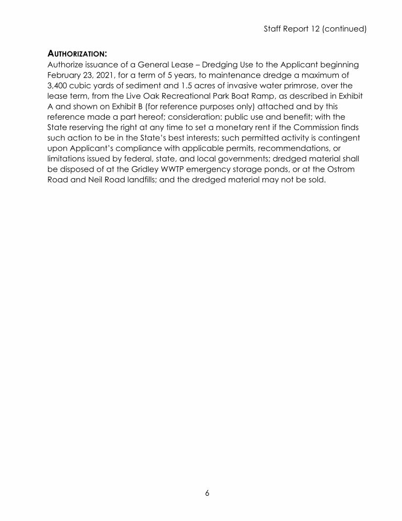
AUTHORIZATION: Authorize issuance of a General Lease – Dredging Use to the Applicant beginning
February 23, 2021, for a term of 5 years, to maintenance dredge a maximum of
3,400 cubic yards of sediment and 1.5 acres of invasive water primrose, over the
lease term, from the Live Oak Recreational Park Boat Ramp, as described in Exhibit
A and shown on Exhibit B (for reference purposes only) attached and by this
reference made a part hereof; consideration: public use and benefit; with the
State reserving the right at any time to set a monetary rent if the Commission finds
such action to be in the State’s best interests; such permitted activity is contingent
upon Applicant’s compliance with applicable permits, recommendations, or
limitations issued by federal, state, and local governments; dredged material shall
be disposed of at the Gridley WWTP emergency storage ponds, or at the Ostrom
Road and Neil Road landfills; and the dredged material may not be sold.

A2702
EXHIBIT A
LAND DESCRIPTION
A portion of sovereign land lying within the bed of the Feather River, adjacent to Section 3,
Township 16 North, Range 3 East, MOM, as projected into the Boga Rancho, also being adjacent
to Lot 171 of "Sunset Colony No. 1" as filed in Bok 1 of Surveys at Page 51, records of the
County of Sutter, State of California, more particularly described as follows:
COMMENCING at a 2" iron pipe marking the southwest corner of Lot 16 of said Sunset Colony
No. 1; thence N 89°23'26" E, 1320.00 feet to a bolt and washer marking the southeast corner
of Lot 17 of said Sunset Colony No. 1; thence N 88°55'38" E, 3088.37 feet to the point of
beginning of the land described in the deed to Sacramento and San Joaquin Drainage District,
Book 735 at Page 148, Official Records of Sutter County; thence N 61 °21'32" E, 623.65 feet to
the POINT OF BEGINNING; thence N 20°23'47" E, 200.00 feet; thence S 69°36'13" E, 650.00
feet; thence S 20°23'47" W, 200.00 feet; thence N 69°36'13" W to the POINT OF BEGINNING.
EXCEPTING THEREFROM any portion lying landward of the low water mark of the Feather
River.
The bearings of Parcel 1 are based on the description stated in the deed to the Sacramento and
San Joaquin Drainage District, recorded in Book 735 at Page 148, Official Records of Sutter
County.
END DESCRIPTION
This description prepared by the Boundary Unit of the California State Lands Commission on
January 29, 2021.
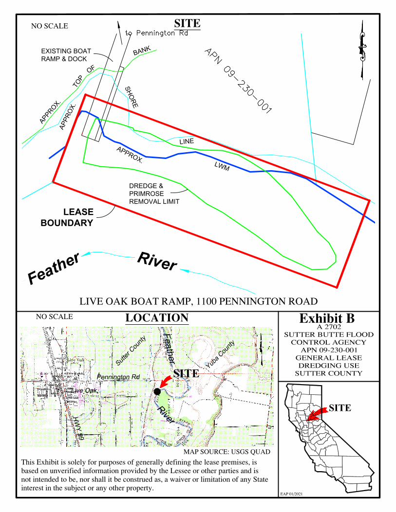
Exhibit B SUTTER A 2702
CONTR~~TIE FLOOD APN GENCY
09-230 00 GENERAL - 1 DREDGIN LEASE
SUTTER CG USE OUNTY
Pen · nington Rd
BANK
Feather
River
TOP
OF
APPROX.
APPR
OX.
SHORE
APPROX.
LINE
LWM
NO SCALE SITE
EXISTING BOAT RAMP & DOCK
DREDGE & PRIMROSE REMOVAL LIMIT
LEASE BOUNDARY
LIVE OAK BOAT RAMP, 1100 PENNINGTON ROAD NO SCALE LOCATION
SITE
SITE
MAP SOURCE: USGS QUAD
This Exhibit is solely for purposes of generally defining the lease premises, is based on unverified information provided by the Lessee or other parties and is not intended to be, nor shall it be construed as, a waiver or limitation of any State interest in the subject or any other property.
EAP 01/2021
AutoCAD SHX Text
.
AutoCAD SHX Text
APN 09-230-001
AutoCAD SHX Text
to Pennington Rd

EXHIBIT C CALIFORNIA STATE LANDS COMMISSION
MITIGATION MONITORING PROGRAM
INITIAL STUDY/MITIGATED NEGATIVE DECLARATION FOR THE LIVE OAK BOAT RAMP SEDIMENT AND INVASIVE VEGETATION REMOVAL PROJECT
(A2702, State Clearinghouse No. 2020100322)
The California State Lands Commission (Commission or CSLC) is a responsible agency under the California Environmental Quality Act (CEQA) for the Live Oak Boat Ramp Sediment and Invasive Vegetation Removal Project (Project). The CEQA lead agency for the Project is the Sutter Butte Flood Control Agency (Agency).
In conjunction with approval of this Project, the Commission adopts this Mitigation Monitoring Program (MMP) for the implementation of mitigation measures for the portion(s) of the Project located on Commission lands. The purpose of a MMP is to impose feasible measures to avoid or substantially reduce the significant environmental impacts from a project identified in an Environmental Impact Report (EIR) or a Mitigated Negative Declaration (MND). State CEQA Guidelines section 15097, subdivision (a), states in part:1
In order to ensure that the mitigation measures and project revisions identified in the EIR or negative declaration are implemented, the public agency shall adopt a program for monitoring or reporting on the revisions which it has required in the project and the measures it has imposed to mitigate or avoid significant environmental effects. A public agency may delegate reporting or monitoring responsibilities to another public agency or to a private entity which accepts the delegation; however, until mitigation measures have been completed the lead agency remains responsible for ensuring that implementation of the mitigation measures occurs in accordance with the program.
The lead agency adopted an MND, State Clearinghouse No. 2020100322, adopted a MMP for the whole of the Project (see Exhibit C, Attachment C-1), and remains responsible for ensuring that implementation of the mitigation measures occurs in accordance with its program. The Commission’s action and authority as a responsible agency apply only to the mitigation measures listed in Table C-1 below. The full text of each mitigation measure, as set forth in the MMP prepared by the CEQA lead agency and provided in Attachment C-1, is incorporated by reference in this Exhibit C. Any mitigation measures adopted by the Commission that differ substantially from those adopted by the lead agency are shown as follows:
• Additions to the text of the mitigation measure are underlined.
1 The State CEQA Guidelines are found at California Code of Regulations, title 14, section 15000 et seq.
February 2021 Page C-1 Live Oak Boat Ramp Sediment and Invasive Vegetation Removal Project

Exhibit C – CSLC Mitigation Monitoring Program
Table C-1. Project Impacts and Applicable Mitigation Measures
Potential Impact Mitigation Measure (MM)2
Difference Between CSLC MMP and Lead Agency MMP
BIO-1: Potential Impacts to Special Status Plants
MM BIO-1: Best Management Practices.
None
BIO-3: Potential Impacts to Special-Status Fish Species, Critical Habitat, and Essential Fish Habitat
MM BIO-3: Special-Status Fish. None
BIO-8: Potential Impacts to Wetlands
MM BIO-8: Waters of the U.S. None
BIO-9: Potential Impacts to Riparian Habitats
MM BIO-9: Riparian Habitat. None
CUL-1: Potential Impacts to Historical or Archaeological Resources
MM CUL-1: Archaeological Monitoring.
None
CUL-2: Potential Impacts to Historical or Archaeological Resources
MM CUL-2: Post-Review Discoveries.
None
CUL-3: Potential Impacts to Human Remains
MM CUL-3: Protocols for Discovery of Human Remains.
See addition below to MM CUL-3
GEO-1: Potential Impacts to Paleontological Resources
MM GEO-1: Discovery of Unknown Paleontological Resources.
None
Additions to existing MM CUL-3: Protocols for Discovery of Human Remains
If it is determined that human remains are found, or remains that are potentially human, then the treatment shall conform to the requirements of State law under California Health and Safety Code Section 7050.5 and PRC Section 5097.98.
For the purposes of this Project, the definitions of remains subject to State law (Section 5097.98) shall apply. This definition states: “(d)(1) Human remains of a Native American may be an inhumation or cremation, and in any state of decomposition or skeletal completeness. (2) Any items associated with the human remains that are placed or buried with the Native American human remains are to be treated in the same manner as the remains, but do not by themselves constitute human remains.” California State Lands Commission staff shall be notified of any human remains discovered on lands under the jurisdiction of the Commission so that the Commission may fulfill its responsibilities as the landowner.
2 See Attachment C-1 for the full text of each MM taken from the MMP prepared by the CEQA lead agency.
February 2021 Page C-2 Live Oak Boat Ramp Sediment and Invasive Vegetation Removal Project

ATTACHMENT C-1
Mitigation Monitoring Program Adopted by the
Sutter Butte Flood Control Agency

MITIGATION MONITORING AND REPORTING PROGRAM
Live Oak Boat Ramp Sediment and Invasive Species Removal Project
Initial Study and Mitigated Negative Declaration December 2020
PREFACE
Section 21081.6 of the California Environmental Quality Act (CEQA) requires a Lead Agency to adopt a Mitigation Monitoring and Reporting Program whenever it approves a project for which measures have been required to mitigate or avoid significant effects on the environment. The purpose of the monitoring and reporting program is to ensure compliance with the mitigation measures during project implementation.
The Initial Study/Mitigated Negative Declaration prepared for the Live Oak Boat Ramp Sediment and Invasive Species Removal Project concluded that the implementation of the project could result in significant effects on the environment and mitigation measures were incorporated into the proposed project or are required as a condition of project approval. This Mitigation Monitoring and Reporting Program addresses those measures in terms of how and when they will be implemented.
This document does not discuss those subjects for which the Initial Study/Mitigated Negative Declaration concluded that the impacts from implementation of the project would be less than significant.

Sutter Butte Flood Control Agency Live Oak Boat Ramp Sediment and Invasive Species Removal Project
MITIGATIONS
MONITORING AND REPORTING PROGRAM Documentation of Compliance
[Project Applicant/Proponent Responsibility] Documentation of Compliance [Lead Agency Responsibility]
Method of Compliance Or Mitigation Action
Timing of Compliance
Oversight Responsibility Actions/Reports
Monitoring Timing or Schedule
Biological Resources Potential Impacts to Special Status Plants
BIO-1: Best Management Practices. The Project shall implement erosion control measures and best management practices (BMPs) to reduce the potential for sediment or pollutants at the Project site. Measures may include: Erosion control measures shall be placed between Waters of
the U.S., and the outer edge of the staging and dewatering areas, within an area identified with highly visible markers (e.g., construction fencing, flagging, silt barriers) prior to commencement of construction activities. Such identification and erosion control measures shall be properly maintained until construction is completed and the soils have been stabilized.
Fiber rolls used for erosion control shall be certified by the California Department of Food and Agriculture as weed free.
Seed mixtures applied for erosion control shall not contain California Invasive Plant Council designated invasive species (http://cal-ipc.org/) and will be composed of native species appropriate for the site.
Trash generated onsite shall be promptly and properly removed from the site.
Any fueling in the upland portion of the Project site shall use appropriate secondary containment techniques to prevent spills.
A qualified biologist shall conduct a mandatory Worker Environmental Awareness Program for all contractors, work crews, and any onsite personnel on the potential for special-status species to occur on the Project site. The training shall provide an overview of habitat and characteristics of the species, the need to avoid certain areas, and the possible penalties for non-compliance.
A qualified biologist/biological monitor shall be onsite during daily construction activities to ensure compliance with the anticipated terms and conditions of the Project regulatory
Project shall implement BMPS prior to and during all project activities.
A qualified biologist shall conduct a mandatory Worker Environmental Awareness Program for all onsite personnel.
A qualified biologist/biological monitor shall be onsite during daily construction activities.
Prior to and during construction.
SBFCA and Project construction lead
Implementation of BMPs, worker training, biological monitoring
Prior to and during construction.
Page 1 of 9

permits and CEQA compliance document. If appropriate, the approved biologist shall train an individual to act as the onsite construction monitor for periods when there is a low risk of effect to special-status species.
BIO-2: Preconstruction Floristic Surveys. Preconstruction floristic surveys shall be conducted for any areas of proposed ground disturbance (i.e., grading or earth work) in the Project site with the potential to support special-status plants. The area of ground disturbance and a 25-foot buffer would be surveyed by a qualified botanist during the appropriate blooming period prior to the start of Project activity. If no special-status plants are found during the preconstruction surveys, no further measures are necessary. If surveys identify any special-status plants, the Project construction manager shall identify them with flagging and avoid them with a 25-foot no-disturbance buffer during Project activities. If this avoidance is not feasible, the Project proponent shall consult with CDFW to determine whether alternative avoidance measures that are equally protective are possible.
Preconstruction floristic surveys Prior to and during construction activities.
SBFCA and Project construction lead
Floristic surveys Prior to and during construction activities.
Potential Impacts to Special-Status Fish Species, Critical Habitat, and Essential Fish Habitat BIO-3: Special-Status Fish. To avoid and minimize potential adverse effects to listed and special-status fish species, designated critical habitat, and essential fish habitat implement the following:
Implement dredging operations during a limited work window (likely June 15 through October 15) to avoid the most sensitive life stages of ESA-listed anadromous fish species.
Deploy measures, as practicable, to reduce sediment resuspension such as a turbidity curtain, if feasible, given the flow volume and velocity in the Project site.
Employ a fish biologist to be onsite as needed to monitor dredging and check spoils (i.e., sediment and vegetation).
Where mechanical dredging is used, attempt to exclude fish and other aquatic organisms from the area using block nets, to the extent feasible for the Project site.
Through the CWA Section 404 process, request the USACE initiate ESA Section 7 Consultation with NMFS on the project effects to ESA-listed anadromous fish species, designated critical habitat, and essential fish habitat.
Consult with CDFW and if necessary, secure an Incidental Take Permit 2081, pursuant to Section 2080 of the California Fish and Game Code.
Implement measures to protect special status fish. Consult with USACE and CDFW for permitting compliance
Prior to and during construction.
SBFCA and Project construction lead
Implement measures to protect special status fish.
Prior to and during construction
Potential Impacts to Special-Status Birds BIO-4: Nesting Birds. To protect nesting birds, no Project Separate preconstruction surveys Prior to and during SBFCA and Project Implement measures to Prior to and during activity shall begin from February 1 through August 31 unless the for nesting birds, raptors, including construction. construction lead protect special status construction following surveys are completed by a qualified wildlife biologist. bald eagle, burrowing owl, and birds. Separate surveys and avoidance requirements are listed below for Swainson's hawk.
Page 2 of 9
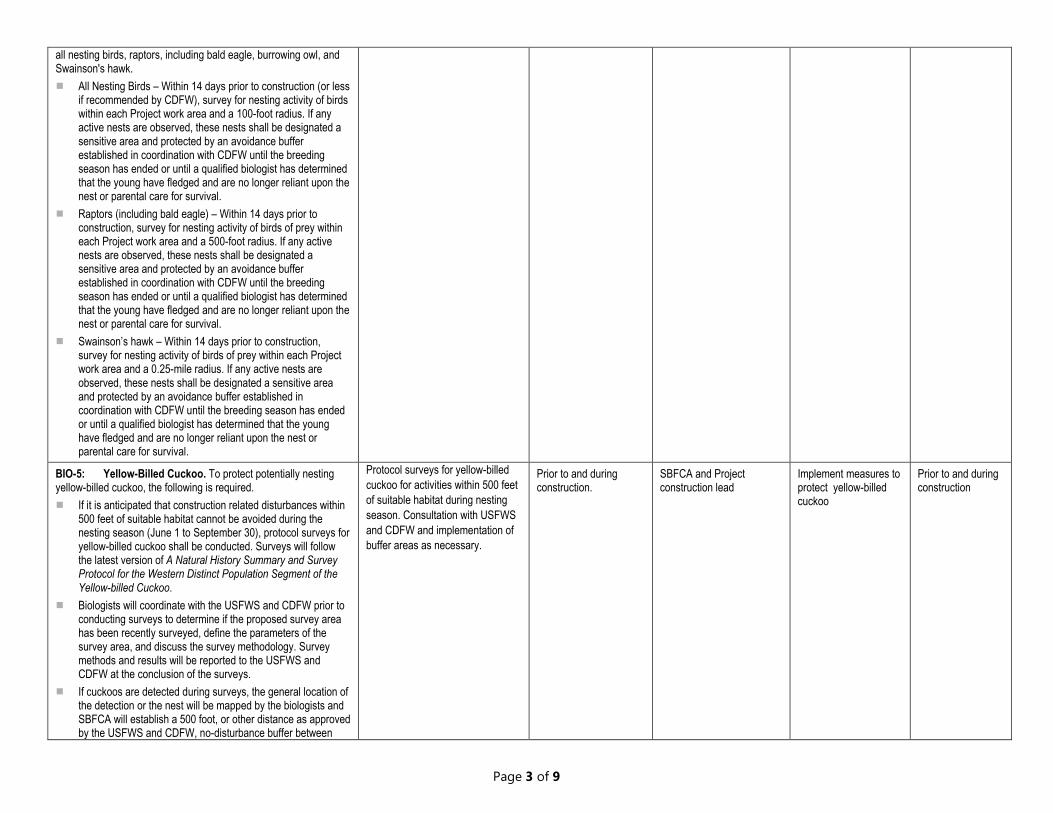
all nesting birds, raptors, including bald eagle, burrowing owl, and Swainson's hawk. All Nesting Birds – Within 14 days prior to construction (or less
if recommended by CDFW), survey for nesting activity of birds within each Project work area and a 100-foot radius. If any active nests are observed, these nests shall be designated a sensitive area and protected by an avoidance buffer established in coordination with CDFW until the breeding season has ended or until a qualified biologist has determined that the young have fledged and are no longer reliant upon the nest or parental care for survival.
Raptors (including bald eagle) – Within 14 days prior to construction, survey for nesting activity of birds of prey within each Project work area and a 500-foot radius. If any active nests are observed, these nests shall be designated a sensitive area and protected by an avoidance buffer established in coordination with CDFW until the breeding season has ended or until a qualified biologist has determined that the young have fledged and are no longer reliant upon the nest or parental care for survival.
Swainson’s hawk – Within 14 days prior to construction, survey for nesting activity of birds of prey within each Project work area and a 0.25-mile radius. If any active nests are observed, these nests shall be designated a sensitive area and protected by an avoidance buffer established in coordination with CDFW until the breeding season has ended or until a qualified biologist has determined that the young have fledged and are no longer reliant upon the nest or parental care for survival.
BIO-5: Yellow-Billed Cuckoo. To protect potentially nesting yellow-billed cuckoo, the following is required. If it is anticipated that construction related disturbances within
500 feet of suitable habitat cannot be avoided during the nesting season (June 1 to September 30), protocol surveys for yellow-billed cuckoo shall be conducted. Surveys will follow the latest version of A Natural History Summary and Survey Protocol for the Western Distinct Population Segment of the Yellow-billed Cuckoo.
Biologists will coordinate with the USFWS and CDFW prior to conducting surveys to determine if the proposed survey area has been recently surveyed, define the parameters of the survey area, and discuss the survey methodology. Survey methods and results will be reported to the USFWS and CDFW at the conclusion of the surveys.
If cuckoos are detected during surveys, the general location of the detection or the nest will be mapped by the biologists and SBFCA will establish a 500 foot, or other distance as approved by the USFWS and CDFW, no-disturbance buffer between
Protocol surveys for yellow-billed cuckoo for activities within 500 feet of suitable habitat during nesting season. Consultation with USFWS and CDFW and implementation of buffer areas as necessary.
Prior to and during construction.
SBFCA and Project construction lead
Implement measures to protect yellow-billed cuckoo
Prior to and during construction
Page 3 of 9

construction activities and the area identified. The no-disturbance buffer will be maintained until it has been determined by a qualified biologist that young have fledged or the nest is no longer active.
Potential Impacts to Special-Status Mammals BIO-6: Ringtail Nest Survey. If the Project requires the removal of upland trees, a qualified biologist shall survey all trees proposed for removal to determine their potential to provide suitable ringtail nest sites (e.g., trees with cavities). If potential nest trees are found, an avoidance area, determined by the survey biologist, shall be fenced and/or flagged around the tree as close to construction limits as possible.
Ringtail nest survey as necessary, implement avoidance area as necessary.
Prior to the removal of trees during construction.
SBFCA and Project construction lead
Implement measures to protect the ringtail
Prior to and during construction
BIO-7: Roosting Bat Survey. If the Project requires the removal of upland trees, a qualified biologist shall conduct a preconstruction roosting bat survey for all suitable roosting habitat (e.g., manmade structures, trees) prior to construction activities. If suitable roosting habitat is identified, a qualified biologist shall conduct an evening bat emergence survey that may include acoustic monitoring to determine whether or not bats are present. If roosting bats are found, consultation with CDFW prior to initiation of construction activities shall be required and implementation of CDFW recommendations shall be required. If bats are not found during the preconstruction surveys, no further measures are necessary.
Roosting bat survey as necessary. Prior to the removal of trees during construction.
SBFCA and Project construction lead
Implement measures to protect roosting bats
Prior to and during construction
Potential Impacts to Wetlands
BIO-8: Waters of the U.S. To avoid or minimize anticipated short-term adverse effects to Waters of the U.S., the Project shall implement the following: If backwater from dewatered dredged spoils has potential to
discharge to wetlands or Waters of the U.S., then a Nationwide Permit 16 (Backwater) under Section 404 of the federal CWA shall be obtained from USACE. The impacts from such actions are expected to be temporary and solely associated with the dewatering activities. Therefore, no net loss of aquatic resources is likely to occur as a result of the Project and no mitigation is required.
A Water Quality Certification or waiver pursuant to Section 401 of the CWA, as issued by RWQCB, shall be obtained for Section 404 permit actions.
If backwater from dewatered dredged spoils has potential to discharge to wetlands or Waters of the U.S., then a Nationwide Permit 16 (Backwater) under Section 404 shall be obtained from USACE.
A Water Quality Certification or waiver pursuant to Section 401 shall be obtained from RWQCB.
A Waste Discharge Requirement shall be obtained from RWQCB.
Prior to and during construction.
SBFCA and Project construction lead
Implement measures to protect Waters of the U.S.
Prior to and during construction
A Waste Discharge Requirement for dredge and fill in Waters of the State under the Porter-Cologne Water Quality Control Act as issued by RWQCB shall be obtained for impacts to waters of the State.
Page 4 of 9

Potential Impacts to Riparian Habitats
BIO 9: Riparian Habitat. Riparian habitat is protected under the California Fish and Game Code. The Project does not expect to require vegetation clearing. Nevertheless, to minimize the potential for impacts to riparian habitat, the following measures are recommended: The river channels shall be accessed via areas where no
permanent impacts to riparian vegetation will be required. A Streambed Alteration Agreement (SAA), pursuant to Section
1602 of the California Fish and Game Code, must be obtained for any activity that will impact the Feather River and riparian habitats. Minimization measures will be developed during consultation with CDFW as part of the SAA agreement process to ensure protections for affected fish and wildlife resources.
Access river channels via areas where no permanent impacts to riparian vegetation will occur.
Obtain a Streambed Alteration Agreement.
Prior to and during construction.
SBFCA and Project construction lead.
Implement measures to protect riparian habitat.
Prior to and during construction.
Page 5 of 9
Sutter Butte Flood Control Agency Live Oak Boat Ramp Sediment and Invasive Species Removal Project
MITIGATIONS
MONITORING AND REPORTING PROGRAM Documentation of Compliance
[Project Applicant/Proponent Responsibility] Documentation of Compliance
[Project Applicant/Proponent Responsibility] Method of Compliance
Or Mitigation Action Timing of
Compliance Oversight
Responsibility Actions/Reports Monitoring Timing or Schedule
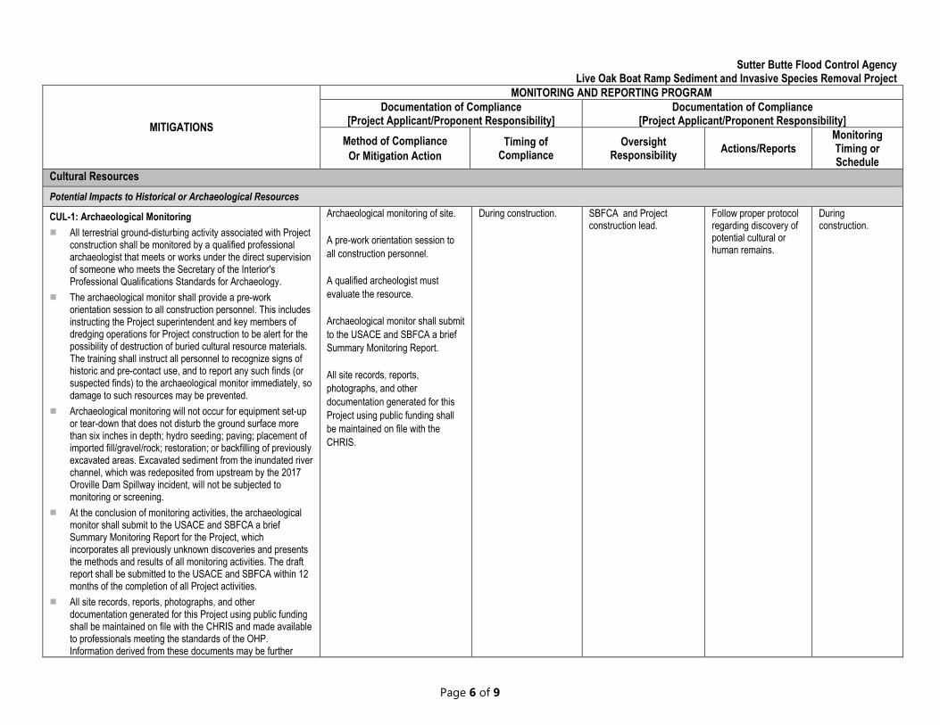
Cultural Resources Potential Impacts to Historical or Archaeological Resources
CUL-1: Archaeological Monitoring Archaeological monitoring of site. During construction. SBFCA and Project Follow proper protocol During
All terrestrial ground-disturbing activity associated with Project construction shall be monitored by a qualified professional archaeologist that meets or works under the direct supervision
A pre-work orientation session to all construction personnel.
construction lead. regarding discovery of potential cultural or human remains.
construction.
of someone who meets the Secretary of the Interior's Professional Qualifications Standards for Archaeology.
The archaeological monitor shall provide a pre-work orientation session to all construction personnel. This includes instructing the Project superintendent and key members of dredging operations for Project construction to be alert for the possibility of destruction of buried cultural resource materials. The training shall instruct all personnel to recognize signs of historic and pre-contact use, and to report any such finds (or suspected finds) to the archaeological monitor immediately, so damage to such resources may be prevented.
A qualified archeologist must evaluate the resource.
Archaeological monitor shall submit to the USACE and SBFCA a brief Summary Monitoring Report.
All site records, reports, photographs, and other documentation generated for this
Archaeological monitoring will not occur for equipment set-up or tear-down that does not disturb the ground surface more than six inches in depth; hydro seeding; paving; placement of imported fill/gravel/rock; restoration; or backfilling of previously
Project using public funding shall be maintained on file with the CHRIS.
excavated areas. Excavated sediment from the inundated river channel, which was redeposited from upstream by the 2017 Oroville Dam Spillway incident, will not be subjected to monitoring or screening.
At the conclusion of monitoring activities, the archaeological monitor shall submit to the USACE and SBFCA a brief Summary Monitoring Report for the Project, which incorporates all previously unknown discoveries and presents the methods and results of all monitoring activities. The draft report shall be submitted to the USACE and SBFCA within 12 months of the completion of all Project activities.
All site records, reports, photographs, and other documentation generated for this Project using public funding shall be maintained on file with the CHRIS and made available to professionals meeting the standards of the OHP. Information derived from these documents may be further
Page 6 of 9

disseminated at professional archaeological conferences or meetings, or to the interested public (with confidentiality maintained).
CUL-2: Post-Review Discoveries For any potential finds, if it is During construction. SBFCA and Project Follow proper protocol During
If the monitoring archaeologist determines that the find is not a cultural resource (such as water-worn cobbles or accumulations of natural materials), then no additional action
determined by the archaeologist that the find does not represent a cultural resource from any time
construction lead. in the event of a cultural or human remains discovery.
construction.
is necessary. Should tribal representatives desire to take possession of those materials, they may do so as long as the possession is documented by the archaeological monitor and as long as removal has been approved in writing by the property owner; however, taking possession does not obligate SBFCA or the USACE to provide fiduciary support for storing, processing, or reburying materials that are not cultural resources. Until a determination is made by the monitoring archaeologist about whether or not the find is subject to further consideration under CEQA, tribal representatives shall not
period or cultural affiliation then no action is required.
If it is determined that the find does represent a cultural resource from any time period or cultural affiliation, SBFCA, USACE and the State Lands Commission shall be notified.
remove or take possession of materials or objects observed. The final disposition of archaeological and historical resources recovered on state lands under the jurisdiction of the California State Lands Commission must be approved by the Commission.
If the find is determined by the monitoring archaeologist to be redeposited material that lacks primary context, is discovered only in the dredged soils, spoil piles, or stockpiles, or is otherwise not in its original context or place of deposition and does not contain human remains, then this discovery is not potentially eligible for the NRHP or California Register of Historical Resources CRHR. The archaeological monitor will assign a temporary field number, take a photograph, record its location with a Global Positioning System receiver, and
The agency shall consult on a finding of eligibility and implement appropriate treatment measures.
If the find includes human remains, or remains that are potentially human, the archaeologist shall ensure reasonable protection measures are taken to protect the discovery from disturbance and notify the proper authorities including Sutter County Coroner
describe the constituents in field notes. If the redeposited find is associated with European or non-Native American culture, the find may be left in place or discarded in order to not interfere with Project activities. If the find is associated with Native American culture, following consultation with the lead agencies, should tribal representatives desire to take possession of those materials or act in any manner consistent with the tribal cultural resources treatment plan, they may do so as long as the possession is documented by the archaeological monitor and as long as permission has been granted in writing by the property owner. However, taking possession does not obligate SBFCA or the USACE to provide fiduciary support for storing, processing, or reburying materials that are not eligible for the NRHP or CRHR. If the find was made in spoil piles and stockpiles, the material may be reused by the Project and will not be subject to screening; however, tribal representatives may take possession of any items found
USACE and/or the THPO.
Page 7 of 9
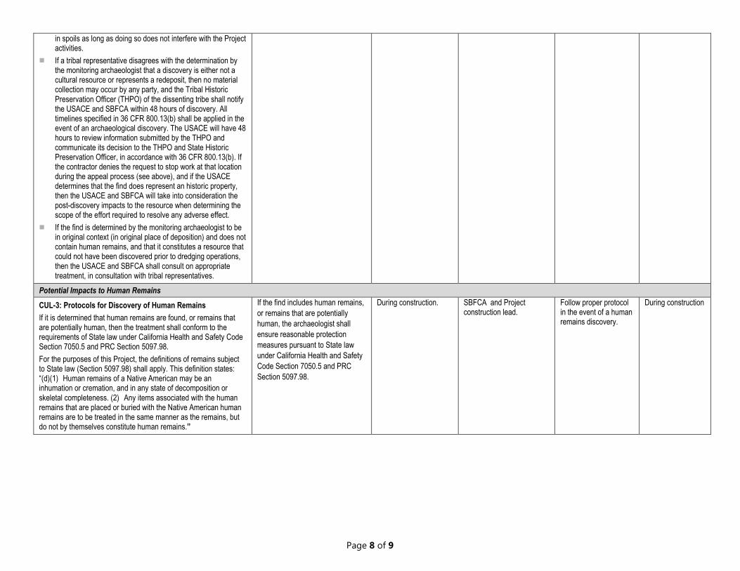
in spoils as long as doing so does not interfere with the Project activities.
If a tribal representative disagrees with the determination by the monitoring archaeologist that a discovery is either not a cultural resource or represents a redeposit, then no material collection may occur by any party, and the Tribal Historic Preservation Officer (THPO) of the dissenting tribe shall notify the USACE and SBFCA within 48 hours of discovery. All timelines specified in 36 CFR 800.13(b) shall be applied in the event of an archaeological discovery. The USACE will have 48 hours to review information submitted by the THPO and communicate its decision to the THPO and State Historic Preservation Officer, in accordance with 36 CFR 800.13(b). If the contractor denies the request to stop work at that location during the appeal process (see above), and if the USACE determines that the find does represent an historic property, then the USACE and SBFCA will take into consideration the post-discovery impacts to the resource when determining the scope of the effort required to resolve any adverse effect.
If the find is determined by the monitoring archaeologist to be in original context (in original place of deposition) and does not contain human remains, and that it constitutes a resource that could not have been discovered prior to dredging operations, then the USACE and SBFCA shall consult on appropriate treatment, in consultation with tribal representatives.
Potential Impacts to Human Remains CUL-3: Protocols for Discovery of Human Remains If it is determined that human remains are found, or remains that are potentially human, then the treatment shall conform to the requirements of State law under California Health and Safety Code Section 7050.5 and PRC Section 5097.98. For the purposes of this Project, the definitions of remains subject to State law (Section 5097.98) shall apply. This definition states: “(d)(1) Human remains of a Native American may be an inhumation or cremation, and in any state of decomposition or skeletal completeness. (2) Any items associated with the human remains that are placed or buried with the Native American human remains are to be treated in the same manner as the remains, but do not by themselves constitute human remains.”
If the find includes human remains, or remains that are potentially human, the archaeologist shall ensure reasonable protection measures pursuant to State law under California Health and Safety Code Section 7050.5 and PRC Section 5097.98.
During construction. SBFCA and Project construction lead.
Follow proper protocol in the event of a human remains discovery.
During construction
Page 8 of 9
Sutter Butte Flood Control Agency Live Oak Boat Ramp Sediment and Invasive Species Removal Project
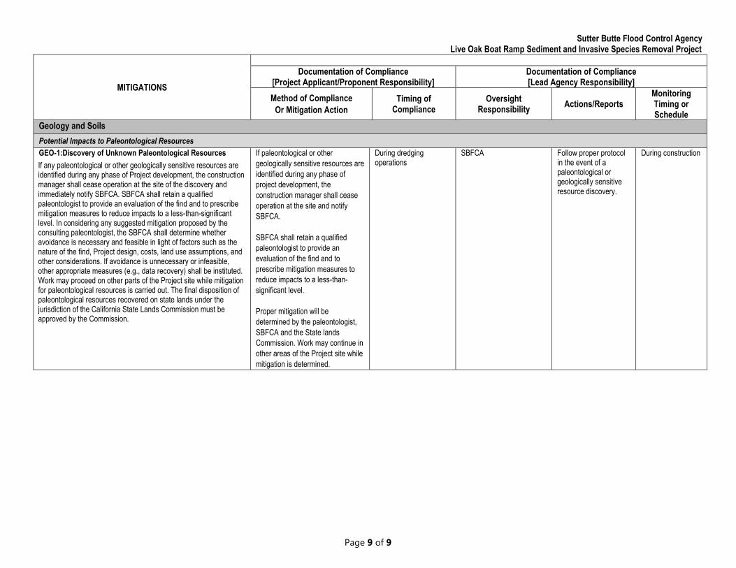
MITIGATIONS Documentation of Compliance
[Project Applicant/Proponent Responsibility] Documentation of Compliance [Lead Agency Responsibility]
Method of Compliance Or Mitigation Action
Timing of Compliance
Oversight Responsibility Actions/Reports
Monitoring Timing or Schedule
Geology and Soils Potential Impacts to Paleontological Resources GEO-1:Discovery of Unknown Paleontological Resources If paleontological or other During dredging SBFCA Follow proper protocol During construction If any paleontological or other geologically sensitive resources are geologically sensitive resources are operations in the event of a identified during any phase of Project development, the construction identified during any phase of paleontological or manager shall cease operation at the site of the discovery and project development, the geologically sensitive immediately notify SBFCA. SBFCA shall retain a qualified construction manager shall cease resource discovery. paleontologist to provide an evaluation of the find and to prescribe operation at the site and notify mitigation measures to reduce impacts to a less-than-significant SBFCA. level. In considering any suggested mitigation proposed by the consulting paleontologist, the SBFCA shall determine whether avoidance is necessary and feasible in light of factors such as the nature of the find, Project design, costs, land use assumptions, and
SBFCA shall retain a qualified paleontologist to provide an
other considerations. If avoidance is unnecessary or infeasible, evaluation of the find and to other appropriate measures (e.g., data recovery) shall be instituted. prescribe mitigation measures to Work may proceed on other parts of the Project site while mitigation reduce impacts to a less-than-for paleontological resources is carried out. The final disposition of significant level. paleontological resources recovered on state lands under the jurisdiction of the California State Lands Commission must be Proper mitigation will be approved by the Commission. determined by the paleontologist,
SBFCA and the State lands Commission. Work may continue in other areas of the Project site while mitigation is determined.
Page 9 of 9