St. Rose, Louisiana 70087 PRODUCER SERVICES LLC
10
DISCOVERY PRODUCER SERVICES LLC 120 Mallard Street, Suite 300, St. Rose, Louisiana 70087 (504) 712-5600 November 2, 1998 Mr. Donald C. Howard, Regional Supervisor United States Department of the Interior Minerals Management Service Gulf of Mexico OCS Region 1201 Elmwood Park Boulevard Harahan, Louisiana 70123-2394 Attention: Mr. David Izon Subject: Completion of the Modification of a 12-inch O.D. Natural Gas and Condensate Pipeline for Discovery Producer Services LLC, Right-of-Way OCS-G 16054, Segment No. 11919, in and/or through Federal Waters, Gulf of Mexico, Offshore Louisiana. Dear Mr. Izon: On behalf of Discovery Producer Services LLC, this correspondence serves as written notification of the completion of work associated with the above subject project. The pipeline modification work was performed as detailed in the Right-of-Way Permit Application dated and submitted to the Minerals Management Service on May 13, 1998, supplemented July 1, 1998, and approved by same on July 10, 1998. The sector of pipeline removed from service from Block 209, Lease OCS-G15324 to Block 207, Lease OCS-G12025, all in the South Timbalier Area designated as Segment No. 11044, was placed in a Temporarily Out of Service condition as detailed on the Right-of-Way Permit Application dated and submitted to the Minerals Management Service last week. Construction was completed on August 25, 1998. Attached you will find three copies of the As-Built drawings for the modifications to the pipeline at the Grand Isle Area Block 104 Platform A, Lease OCS-G-14560 and at the 30-inch SSTI Block 209 South Timbalier Area, Lease OCS-G15324, Segment No. 11161, Right-of-Way OCS-G- 16093. Also attached are three copies each of the hydrostatic test results and the instrument cafibration reports.
Transcript of St. Rose, Louisiana 70087 PRODUCER SERVICES LLC

DISCOVERYPRODUCER SERVICES LLC
120 Mallard Street, Suite 300, St. Rose, Louisiana 70087
(504) 712-5600
November 2, 1998
Mr. Donald C. Howard, Regional Supervisor United States Department of the Interior Minerals Management Service Gulf of Mexico OCS Region 1201 Elmwood Park Boulevard Harahan, Louisiana 70123-2394
Attention: Mr. David Izon
Subject: Completion of the Modification of a 12-inch O.D. Natural Gas andCondensate Pipeline for Discovery Producer Services LLC, Right-of-Way OCS-G 16054, Segment No. 11919, in and/or through Federal Waters, Gulf of Mexico, Offshore Louisiana.
Dear Mr. Izon:
On behalf of Discovery Producer Services LLC, this correspondence serves as written notification of the completion of work associated with the above subject project. The pipeline modification work was performed as detailed in the Right-of-Way Permit Application dated and submitted to the Minerals Management Service on May 13, 1998, supplemented July 1, 1998, and approved by same on July 10, 1998. The sector of pipeline removed from service from Block 209, Lease OCS-G15324 to Block 207, Lease OCS-G12025, all in the South Timbalier Area designated as Segment No. 11044, was placed in a Temporarily Out of Service condition as detailed on the Right-of-Way Permit Application dated and submitted to the Minerals Management Service last week.
Construction was completed on August 25, 1998. Attached you will find three copies of the As-Built drawings for the modifications to the pipeline at the Grand Isle Area Block 104 Platform A, Lease OCS-G-14560 and at the 30-inch SSTI Block 209 South Timbalier Area, Lease OCS-G15324, Segment No. 11161, Right-of-Way OCS-G- 16093.
Also attached are three copies each of the hydrostatic test results and the instrument cafibration reports.

November 2, 1998 Mr. David Izon Page 2
Should you have any questions or require further information, please contact Mr. Leigh Larson, Project Director, at Project Consulting Services, Inc. (504) 833-5321.
Sincerely,
Discovery Producer Services LLC
Cst*) 7li-Project Manager
LL/jm
Enclosures
cc: Larry Johnson, Bridgeline Gas Distribution LLC - w/oLeigh Larson, Project Consulting Services, Inc. - w/o PCS File 97172

DownHole
Pressure, Inc.INSTRUMENT RENTALS & REPAIRS
1036-A South Cruse Ave. Broussard, LA 70518
Phone (318) 837-2755Fax (318)837-2756
Surface Gauges Dead Weight Testers
Barton Recorders Vaetrix Gauge 1
5, 10 & 20.000 PSI
Sub Surface Gauges Electronic & Mechanical
0-25.000 PSI Ranges Temperature Gauges
0-450 Degrees F.
CALIBRATION CERTIFICATE
VAETRIX GAUGE 1
SERIAL NUMBERicmi^
PRESSURE RANGE/0J Q-fiO PS,
r>
Calibrated in Vertical Position Temperature F.
This is to certify that this instrument has been inspected and tested against Pressure Standard Chandler Engineering Dead Weight Tester Model # 58-200H, Serial # 16210 traceable to the National Institute of Standards and Technology, NIST Reference ft 105, Procedure # MTP-132. Calibration Certification No. 031798-01. The calibration system conforms to the requirements of MIL-STD. 45662A as ISO-9000 procedures. Date Calibrated (03/23/1998).
Special Conditions:
DATE OF CALIBRATION TECHNICIAN

DownHole
Pressure, Inc.INSTRUMENT RENTALS & REPAIRS
1036-A South Cruse Ave. Broussard, LA 70518
Phone (318) 837-2755Fax (318) 837-2756
Surface Gauges Dead Weight Testers
Barton Recorders Vaetrix Gauge 1
5, 10 & 20,000 PSI
Sub Surface Gauges Electronic & Mechanical
0-25,000 PSI Ranges Temperature Gauges
0-450 Degrees F.
CALIBRATION CERTIFICATE
BARTON METER
SERIAL NUMBERcJ'/j-E' S'IJOS'PRESSURE RANGE So 00 psi
Calibrated in Vertical Position Temperature F.
This is to certify that this instrument has been inspected and tested against Pressure Standard Chandler Engineering Dead Weight Tester Model # 58-200H, Serial # 16210 traceable to the National Institute of Standards and Technology, NIST Reference # 105, Procedure # MTP-132. Calibration Certification No. 031798-01. Date calibrated (03/23/1998). The calibration systems conforms to the requirements of MIL-STD. 45662A as ISO-9000 procedures.
Special Conditions:

DownHole
Pressure, Inc.INSTRUMENT RENTALS & REPAIRS
1036-A South Cruse Ave. Broussard. LA 70518
Phone (318)837-2755Fax (318)837-2756
Surface Gauges Dead Weight Testers
Barton Recorders Vaetrix Gauge I
5, 10 & 20,000 PS1
Sub Surface Gauges Electronic & Mechanical
0-25,000 PSI Ranges Temperature Gauges
0-450 Degrees F.
TEMPERATURECALIBRATION CERTIFICATE
BARTON METER
SERIAL NUMBER RANGE_ DEG. F
Calibrated in Vertical Position
This is to certify that this instrument has been inspected and tested against Digital Thermometer No. 301800, Calibrated (05/08/1998). Traceable to the National Institute of Standards & Technology (NIST). Lab Accurate Digital Thermometer Mobil TM 99 (Post Thermometer). Serial No. 188320.
Special Conditions:
DATE OF CALIBRATION 7- 7- f / TECHNICIA


02-Jun-0 TIMS.PPL MASTERS03 Data Entry/Change Sheet
Screen 1
Segment Number: 11919 — Comes From —
ROW Number: G16054 Id Name: A
Operator Code: 02273 Lease Number: G14560aggaMPiscoveiv Producer Services LLC
Area Code: GI
ROW Permittee: 02273 Block Number: 104^^^BOisco.eiv Producer Services LLC
— Goes To —
Approval Code: R Id Name: 30 SSTI
Authority Code: TLease Number: G15324
Size Code:
Product Code:
12
G/CArea Code: ST
Alt Product Code: Block Number: 209
Screen 2
Segment Length: 68514 Buried Designator Flag: Y
Fed + State Length: 68514 Recv MAOP: 1850
Pipeline Approval Date: 7/10/1998 Recv Segment Number: 11161
ROW Issue Date: 7/12/1996 MAOP Type: O
Init HTP Date: 9/29/1996MAOP (Pressure): 1850
Recent HTP Date:Departure Flag:
Anode Inst Date:Pipeline Status Code: PROP
ROW Status Code: ACTCathodic Code: A
Leak Detection Flag: NCath Life Time: 20
Map OPD Number:Bidirectional Flag: N
Board PL SDV Flag:Liquid Sys Dcsig Code:
Board PL FSV Flag: N
Gas Sys Desig Code: Abandon Apr Date:
Minimum Water Depth: 177 Abandon Date:
Maximum Water Depth: 200 Abandon Type:

813 Pipeline Permit Tracking Screen|j 016054 11919 12 GC Gl 104 A SI 209 30 SSI PTffili rtlFftlj
Record! Nj
Permit Type Date on DateApplication Received ROW Ho. Operator ^ Engineer
>««»»
ms>f ,,To Date
Signature: Approved:
j{;n 3.-1996 /l 996 pi 605 4 pscovery Producer S
Description of Pipeline:
I??* ni •,«■ “&e* iso,.
HEPA Review (MS 5440} MHazards Review (MS 622?> M FWS JM
HMJS m
ADJUDICATION (MS 6421i ^Platform Verification j|Wstrict
Application Fee (Denver)
Print Trans Memos
On Shore Base:
Comments Requested bjR
Engineering ok Hd
General Remarks;
Verbal Approval? Completion Report
Report Report ReportDate Received To Type
llAwlSwl 1 JiuJn^yd I 11 R&n333
Report Report To Accepted
Address
Avrwai i
'■ : ■ w v
■4%■ss;IIiiv'
■••••'•••
m■

a;
3I
£o!>>
oo
too
oo>
oo>rO
(NJI!X
Oo
CDO
bOi
x:
£aQ
GI100OCS-G-08732
Block Lino Crossing
X= 2,398,627.73’Y= —80,372.21'
Y=-80,0000-0- 0 ---^o
ST2I0
-0-0 oo o o o• O 0-0-0-1 BO 170
-O' O-O-O-O—o-o-o-o—<
160
ooobo
(NII
X
&=cOo
o
bO)
oooo'X—
<NIIX
GI99
ui
1O<2
o Oo o-oo- O O O O O 00^0 00 o
150 ——FLOW 140
488 + 39.31Are a Line Cro ssing
X= 2,385,227.73'Y= -80,219.33'Lat. 28“ 26’ 25.994”N Lon. 90° 08’ 06.158"Vf
GI101OCS—G—05661
o-o—o-o- —o---0—0120
MO 100o—o O-O-I o o
n:o
F—<
GI102OCS-G-05662
oo
c\?o
oO)
oooo'
'T(i
IIX
GI98
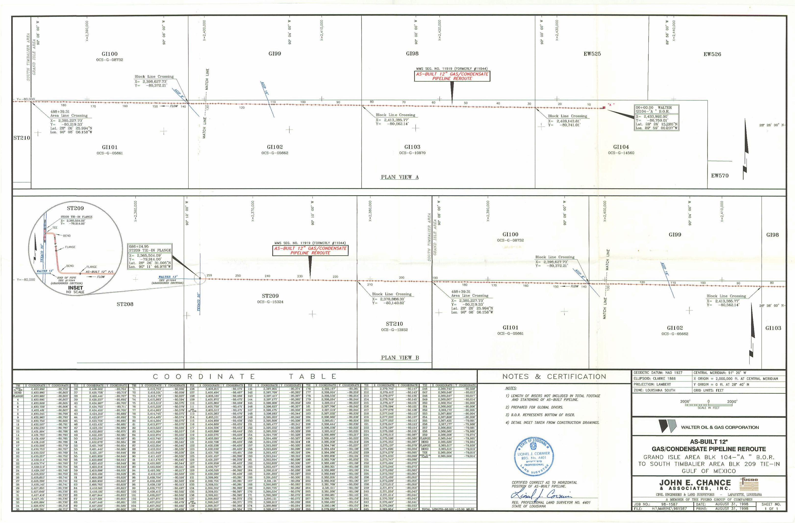
MMS SEG. HO. 11919 (FORMERLY #11044)
AS-BUILT 12" GAS/CONDENSATE PIPELINE REROUTE
70-B O O o <0 O o o >
60 ! 50, o--- O 0 0-0-0-0 o O OOo-O o-o—o o
40
Block Lin.e Crossing
X= 2,413ll385.77’Y= -80',562.14’
GI103OCS—G—10870
PLAN VIEW A
Oo
oo
oOl
oo
o"IO
bIIX
EW525
i*
oo
co<n
bto
ooos'
'i-cnT
IIX
EW526
Block Line Crossing
X= 2,428,143.81'Y = -80,741.01'
00+00.00 WALTERGI104-"A ■■ B.O.R.
X= 2,433,992.00’Y= -80,759.01’Lat. 28° 26' 1 5j285”NLon. 89° 59’ 00.K07’’W
GI104OCS-G—14560
28° 26 00 N-
EW570
- Y=-80,000
686 + 24.95ST209 TIE-IN FLANGE
X= 2,365,504.09'Y= -79,914.00’LaL. 28" 26' 31.005”NLon. 90“ 11' 46.978"W
WALTERSEG H11044
(ABANDONED SECTION)
ST208
*
oo
CO
bo
s<DCDPnro<N
IIX
too
oOJ
MMS SEG. NO. 11919 (FORMERLY #11044)
AS-BUILT 12" GAS/CONDENSATEPIPELINE REROUTE
\ 259 250 240-0-0 0 O O O 0 0 0-0-0-0—o -o—©<
230 220O O—-0-0 - o—o-o- o-o--0-0-
ST209OCS-G—15324
ooqbcotob
‘-Y
*-•1NT1
£OCo
2000-0-0210
0 o -O-o- Ol o
Block l.ine Crossing
X= 2,378,806.3O'Y= -80,140.82'
ST210OCS—G—13932
PLAN VIEW B
Oo
COo
ST oO04 ^
I-.-,
oooo'Oltoc-i
X
soo
fDO
oOl
GI100OCS-G —08732
9-1'
Block Line Crossing
X= 2,398,627.73’Y= -80,372.21'
190
180
488+39.31 Area Line
170-0 -0 O 0 0-0
160
Crossing
X= 2,385,227.73'Y= -80,219.33’Lat. 28“ 26’ 25.994’’N Lon. 90° OB' 06.158”W
150
GI101OCS-G-05661
qCDCD•4-CN
IIX
IS
oo
+o
o01
qo'
bIIx
GI99
lu2
120 100 90o o
XoK<
Block Line Crossing
X= 2,413,385.77’Y = -80,562.14’
GI102OCS-G-05662
GI98
80o o-o—o o-
20" 26' 00" N-
GI103
COORD N A
TIE«ltBEND
M.AM>
10
II12
13U151617IB19202122232425262720293031323334
X COORDINATE2,433,992'2,433,990'2,433,982'2,433,8952,433,8092,433,7292.433,4812,433,2452,432,9632,432,760 2,432,507* 2,432,230' 2,431,994 2,431,703’ 2,431,499’ 2,431,240’ 2.430,990’ 2.430,753' 2,430,520'
Y COORDINATE00.750'00.003'00.003'00,007'80,005’80,000'
-00,007-00,799-00,793-80,000-80,791-80,787-80.786-80,793-80,786
2,430,2572,430,0142,429,7742,429,5192,429,190’2,420.032;2,420,653'2,4211,390'2,42(1,142'2.427,855' 2,427,649' 2.427,410' 2,427,161T
2,426,8842,426,670
91
00,78660,779'00,767'00.769'00,752’00,760'80.760'
-00,754-00,746-00,750-00,741-00,741-00.741
00,736•00,739’00,733'00.730'00,730’-00.710'
TIE363738 39^ 40 43 42_4344454f5474044)50515253 54_ 55 50 5^ 5859
JK)
J1Ji2m6465qE676fJ_69^A
X COORDINATE Y COORDINATE2,436,022'2,485,728’2,425,441’2,425,237’
2,424,9972.424,703'2,424,450’
-00,704’-00,718'-00,707'-00,692'-00,705'
-00.711-00,700
2.424.219’ -80,6892,423.977’2,423,7262,423,4322,423.104’2,422,000'2.422.4952,422,240'2.422.070'2,421.760'2,421,442’
2,421,1072,420,9392,420,6963,420,4532,420,216'2,419,8902,419,494'2,419,266'2,418.930'2,418,763'2,418.516'2,418.192'2,417,944’
2,417,6912,417,4462,417,200
-80.692-00,692-80,685-00,609’-00,675-00.601
00,667 00,664' 00.654' 00,665" 00,646’
-00,645-00,043-00,640-00,040-00,636-00,620-00,626
00.62600.620’00.623’00,622'80,633'-80,600’
-80,601-80,589
Mim -80.602
TIE7172737475 7077707900810203048586
0700099091
X COORDINATE2,410,7032.41 6,5012.418,175'2,415.0(13’2.415.510’2,415,220’2.414,963’2,414.745'2,414,4652,414,2642.413.9772.413.5232,413,2042,412,9742,412,7402,412,490
9293949596979899100 101 102 103104105
2,412,2542,412,014'2,411,649'2,411,'HQ' 2,411,170’2,410,9252,410,6042,410,3612,410,1102.409,7942,409,4602,4 09,139 2,408.773' 2.400,415’ 2.400.207' 2,407.871’ 2,407.552'2,407,302
Y COORDINATE-80,602'-80,609’-80,607-80,594’
80,57500.579'00,579'00,573
-00,574-80,572-80,570-00,566-00,557'-00,555'
-00,550-00.542'-00.540 00.539 00.539 00.532' 80.545'
-80,644-80,541-80,617-80,633-80,516-00,503
00,51300,497'00,502'00,503’
-00,506-00,479'-00,400
TIE10610710810911011
113114115
X COORDINATE2,400,81 52,406,4942,406,1802.405,9722,405,8692,405,739’
116117110110120
121
122123124125126 127120
129130131132133134135136137
130
m
8,405,513 2,405,263' 2,405,101'2,404,9392,404,609'2,404,3362,403,8992,403,5752,403,2102,402,7262,402,2382,402,0322,401,7052,401,467’2,401,207'2,400,959'2,400,717'2,400.5102,400,2002.399.9012,390,7562,399,551 2,390,302’ 2,399,051 ’ 2,390,921 2.390.003’ 2.390.54 5’2,390,357
Y COORDINATE-00,473'
-00,467-00,488-80,473-00,409-00,471-00,471-00,470-00,462
00.450-00.456'-00,453'-00,440-00,420-00,440-00.433-00.420-00.420-00,401-00,396-00,370
00,40300,391’
-00,392-00,409-00,391-80,301-80,391-80,393-80,397'-00,393
00,37300.371'00,360
TIE141142143144145146147140149160151162153154155150157150159160161162163164165
167160169170171172173174A
X COORDINATE2,397.955'2,397,709'2,397,417'2,397,177'2,396,926'2,396.637'2,396,4752,396,1632,395,9332,395.000’2,396.477’2.396,232'2,395,036’2.394,730’2.304.400'2,394,230’2.393.990’2,393,690’2.393.463'2.393.2442,392,994'2,392.660'2,392,467’2,392.216'2,391.090'2.391,562’2,391,191’2,390,905'2.390,735'2,390,5342,390,369'2.390,121'2.309,913'2.309.660’
COORDINATE-00.374'-00.363'-00,367'-00.365’-00,350’-80.357'-80.356’-80,344’-80.342’-80.326’-80.341-80,329'-00,329'-00,320'-00,327'-00,324’-80,320'-80,290'-80,316'-80,310'-80,298’-00,306-80,300'-00,200'
-00,297'-00,305-00,201-00,203'-80,202'-80,276-00,272'-00,273-00,260-00,264
TIE
B L EX COORDINATE
176177170179100181102
183184185106107100109190191192193194195196197198199200201202203204205206207200
209
2,309.167'2.300,924’2.300,556'2.300.264'2,300.014'2,387,766'2.387.519'2,387,232'2,306,982’2,300.611’2,306.444'2,306,230’2,305,912’2,305,669’2,305,450’2,305,200'2,304,746'2,304,464'2,304,266'2,303,936'2,303,709'2,383,490’2,303,301'2,302,960'2,302,6492,302,2052,302,0022,301,769'2,381,6112,301,2662,300,9012,300,7212,300,4032,300,196
Y COORDINATE-80,261-00,259'-00,254-00,244-00,223-00,242-00,244’-80,239-80,236-80,224'-80,230'-00,222-00.226-00,217-00,223-00,219-00,207-00,190-00,202-00,194-00,202-80,186-00,106'-00,190-00,192-00,100-00,190-00,200-00,100-00,199-00,145-00,150-00.154’-00,150
TIE211212213214215216217218219220
221222223224225220227220229230231232233234235236237230239240241242243244
x coordinate:2,379,7402,379.4132,379,077'2,370,7492.370,417'2,370,0942,377,0702,377.5482.377,3032.377,0532.370,047'2.376.5972.370.2662.370.0132.375,5902.375.3532,375.1072.374,6962.374,2792,374,0332,373,7472,373.4942,373.240'2,373,002’2,372,760’2,373,4602,372,2992,372,0122,371,6742,371,2592,371,0142,370.7292,370,447’2,370,240’
"COORDINATE
-00,147’-00,143’-00,135'-00,145'-60,131'
-00,121'-00,126'-00,112'-00,107’-00,113'-80,113'-00,114-00,105'-00,007’-00.000'-00,007'-00.079’-00,004’-00,005'-00,069’
-00,000’-00,070'-00,073'-00,003'-00,064'-00,050'-80.056'-00.059’-00,056'-00,043'-80,044’-80,043'-00,041'-80,033'
—
246247240249260251262253254266266267260269
FLANGEBEND
FLANGEBENDTEE
mjiyj te—isll/HGE
X COORDINATE2.369,743’2.369.546’2,369,247’2,369.007'2,360,754'2,360.502’2.360,173’2,367,920’2.367.620’2,367.425'2,367,177’2,366,0552,306,5602,366,3062,365,5442,305,6202,365,5172,365,5152,365,6042,365,604'
Y COORDINATE-00,020'-00,013'-00,017'-00,014'-00,009'-80,006'-00,005'-00,004-00,006’-79,991'-79,900'-79,901’-79,900'
-79,974’-79,965*-79.064'-79,939’-79,919’-79,919'-79,914’
NOTES & CER CATION
NOTE'S:
1) LENGTH OF RISERS NOT INCLUDED IN TOTAL FOOTAGE
AND STATIONING 0E AS-BUILT PIPELINE.
2) PREPARED FOR GLOBAL DIVERS.
3) B.O.R. REPRESENTS BOTTOM OF RISER.
4) DETAIL INSET TAKEN FROM CONSTRUCTION DRAWINGS
CERTIFIED CORRECT AS TO HORIZONTAL POSITION OF AS-BUILT PIPELINE.
REG. PROFESSIONAL LAND SURVEYOR NO. 4401 STATE OF LOUISIANA
GEODETIC DATUM: NAD 1927
ELLIPSOID: CLARKE 1866
PROJECTION: LAMBERT
ZONE: LOUISIANA SOUTH
CENTRAL MERIDIAN: 91* 20’ W
X ORIGIN = 2,000,000 ft. AT CENTRAL MERIDIAN
Y ORIGIN = 0 ft. AT 28* 40’ N
GRID UNITS: FEET
2000’bzE
2000’
SCALE FEET
WALTER OIL & GAS CORPORATION
AS-BUILT 12"GAS/CONDENSATE PIPELINE REROUTE
GRAND ISLE AREA BLK 104-”A ” B.O.R. 0 SOUTH TIMBALIER AREA BLK 209
GULF OF MEXICON
IS5B20JOHN E. CHANCE& ASSOCIATES, INC.
CIVIL ENGINEERS k LAND SURVEYORS - LAFAYETTE, LOUISIANA
A MEMBER OF THE FUGRO GROUP OF COMPANIES
JOB NO.: 98-1587
FILE: H:\1MARINE\i'981587DATE: AUGUST 31, 1998
PRINT: AUGUST 31, 1998SHEET NO.
1 OF 1