SPHERICAL BOULDERS IN NORTH-CENTRAL ARKANSAS 22 Prim Boulders.pdf · state of arkansas arkansas...
24
STATE OF ARKANSAS A RKANSAS G EOLOGICAL C OMMISSION Bekki White, State Geologist MISCELLANEOUS PUBLICATION 22 SPHERICAL BOULDERS IN NORTH-CENTRAL ARKANSAS by William D. Hanson and J. Michael Howard Little Rock, Arkansas 2005 MP-22
-
Upload
truonghuong -
Category
Documents
-
view
219 -
download
4
Transcript of SPHERICAL BOULDERS IN NORTH-CENTRAL ARKANSAS 22 Prim Boulders.pdf · state of arkansas arkansas...
STATE OF ARKANSAS
ARKANSAS GEOLOGICAL COMMISSION
Bekki White, State Geologist
MISCELLANEOUS PUBLICATION 22
SPHERICAL BOULDERS IN NORTH-CENTRAL ARKANSAS
by
William D. Hanson and J. Michael Howard
Little Rock, Arkansas
2005
MP-22
1
Are
as w
ith sp
heric
al b
ould
ers p
rese
nt
Figu
re 1
- G
ener
al lo
catio
n m
ap o
f sph
eric
al b
ould
ers
in n
or
th-c
entra
l Ark
ansa
s.M
odifi
ed fr
om th
e Ark
ansa
s Sta
te B
ase
Map
, Sca
le 1
:500
,000
.
SCA
LE:
1:72
0,00
0
Are
a of
stud
y
1
STATE OF ARKANSAS
Arkansas Geological Commission
Bekki White, State Geologist
MISCELLANEOUS PUBLICATION 22
SPHERICAL BOULDERS IN NORTH-CENTRAL ARKANSAS
by
William D. Hanson and J. Michael Howard
Little Rock, Arkansas
2005
1
STATE OF ARKANSAS
Mike Huckabee, Governor
Arkansas Geological Commission
Bekki White, Director and State Geologist
Commissioners Dr. Richard Cohoon, Chairman …………………………………………….…Russellville Brad DeVazier ………………………………………………………………...Forrest City David J. Baumgardner …………………………………………………………Little Rock John Blake …..……………………………………………………………..Siloam Springs David Lumbert …………………………………………………………………Little Rock James W. Parham ……………………………………………………………..…Magnolia William Willis ………………………………………………………………....Hot Springs
Little Rock, Arkansas
2005
ii

1
Table of Contents Introduction . . . . . . . . . . . . . . . . . . . . . . . . . . . . . . . . . . . . . . . . . . . . . . . . . . . . . . 1 Previous Work . . . . . . . . . . . . . . . . . . . . . . . . . . . . . . . . . . . . . . . . . . . . . . . . . . . . . . 1 Field Methods . . . . . . . . . . . . . . . . . . . . . . . . . . . . . . . . . . . . . . . . . . . . . . . . . . . . . . 2 Topography . . . . . . . . . . . . . . . . . . . . . . . . . . . . . . . . . . . . . . . . . . . . . . . . . . . . . . 2 Geology . . . . . . . . . . . . . . . . . . . . . . . . . . . . . . . . . . . . . . . . . . . . . . . . . . . . . . 2 Location of Spherical Boulders . . . . . . . . . . . . . . . . . . . . . . . . . . . . . . . . . . . . . . . . . . . 4
Cleburne County . . . . . . . . . . . . . . . . . . . . . . . . . . . . . . . . . . . . . . . . . . . . . . . . 4
Newton County . . . . . . . . . . . . . . . . . . . . . . . . . . . . . . . . . . . . . . . . . . . . . . . . 10
White County . . . . . . . . . . . . . . . . . . . . . . . . . . . . . . . . . . . . . . . . . . . . . . . . 13 Origin of Spherical Boulder . . . . . . . . . . . . . . . . . . . . . . . . . . . . . . . . . . . . . . . . . . . . 14 Economic Geology . . . . . . . . . . . . . . . . . . . . . . . . . . . . . . . . . . . . . . . . . . . . . . . . . . . . 15 Summary . . . . . . . . . . . . . . . . . . . . . . . . . . . . . . . . . . . . . . . . . . . . . . . . . . . . . . . 16 References . . . . . . . . . . . . . . . . . . . . . . . . . . . . . . . . . . . . . . . . . . . . . . . . . . . . . . . 16
________________________________________________________________________
Figures 1. General location map of spherical boulders in north-central Arkansas . . . . . Inside Cover 2. General stratigraphic chart for north-central Arkansas . . . . . . . . . . . . . . . . . . . . . . . . 3 3. Collection of spherical boulders next to the Prim, Arkansas Post Office. . . . . . . . . . . 4 4. A common agricultural practice is to remove boulders from pastures and to place them in an out-of-the-way site . . . . . . . . . . . . . . . . . . . . . . . . . . . . . . . . . . . . 5 5. A highly spherical boulder in the corner of a pasture . . . . . . . . . . . . . . . . . . . . . . . . . . 5
iii

1
6. Full decorative potential recognized with this boulder . . . . . . . . . . . . . . . . . . . . . . . . . 6 7. Numerous boulders occur at this site down slope from sandstone outcrop . . . . . . . . . . 7 8. Breached boulder showing interior. Note the thin iron-enriched zone on boulder to the left. . . . . . . . . . . . . . . . . . . . . . . . . . . . . . . . . . . . . . . . . . . . . . . . . . . . 7 9. Top of boulder just being exposed. Note the iron-enriched zone on left side of
boulder . . . . . . . . . . . . . . . . . . . . . . . . . . . . . . . . . . . . . . . . . . . . . . . . . . . . . 8 10. Large spherical boulders weathering from outcrop . . . . . . . . . . . . . . . . . . . . . . . . . . 9 11. Peanut-shaped boulder is the result of two concretions growing together during
cementation . . . . . . . . . . . . . . . . . . . . . . . . . . . . . . . . . . . . . . . . . . . . . . . . . 9 12. This boulder in Murphy Hollow is approximately 12 feet in diameter and well removed from the host formation . . . . . . . . . . . . . . . . . . . . . . . . . . . . . . . . 10 13. Boulders in large detrital block. Note the well developed iron-enriched zone on the boulder to the right . . . . . . . . . . . . . . . . . . . . . . . . . . . . . . . . . . . . . . 11 14. Spherical concretions weathering from host sandstone at nearly the same rate as the host rock at Alum Cove Natural Bridge . . . . . . . . . . . . . . . . . . . . . . 12 15. Honeycomb weathering and large spherical erosion markings in Prairie Grove
Formation at Farmer Cove Bluff . . . . . . . . . . . . . . . . . . . . . . . . . . . . . . . . . 12 16. Calcite-cemented broken boulder measures 5 feet by 7 feet. Note that at this
fresh outcrop that the boulder displays no iron enriched zone . . . . . . . . . . 13 17. Calcite-cemented boulder measures 2.5 feet in diameter in quarry face. This
boulder will be used for the local decorative stone market . . . . . . . . . . . . . 14
Table 1. Location and Ownership Table . . . . . . . . . . . . . . . . . . . . . . . . . . . . . . . . . . . .Fold-out page
iv
1
SPHERICAL BOULDERS IN NORTH-CENTRAL ARKANSAS
by
William D. Hanson and J. Michael Howard Introduction
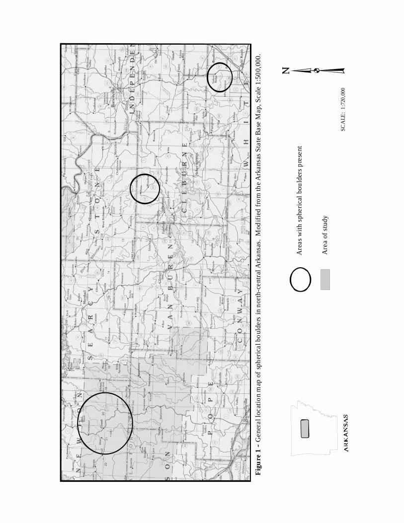
For many years, the region around Prim, Arkansas has been known for its large round sandstone boulders, commonly ranging in diameter from 1 foot (0.3 m) to 4 feet (1.3 m). These boulders are not restricted to the Prim, Cleburne County area, however, similar boulders have been seen in situ at Alum Cove Natural Bridge and vicinity in southern Newton County to the west and in the Peacock Road quarry in northern White County to the east.
This is a distance of some 100 miles (161 km) on a trend of S 71o E. (fig. 1 – General location map-inside front cover). The Prim occurrences are just north of this general trend and are notable because of the large number of completely released free-standing spherical boulders. The boulders are present in certain sandstone beds of Morrowan age rocks.
These occurrences of spherical boulders were studied to provide a better understanding of their formation, distribution, and economic potential as decorative stones. A primary purpose of the study was to document specific boulder localities in and around Prim and to extend the known locations to the east and west. This was done with the assistance of local individuals and incorporated field data from other Arkansas Geological Commission (AGC) staff geologists.
Previous Work
Local farmers and ranchers knew about the spherical boulders in the vicinity of Prim, northern Cleburne County, long before they were brought to the attention of geologists, because they were a nuisance to normal agricultural practices. Many of the boulders were moved from their original locations to the edges of fields or into piles and were also distributed along driveways, home entrances, or into front yards as decorative items.
Tom Freeman (1964), AGC staff geologist, was the first scientist to write about the Prim boulders in an AGC Open-file report. His report, although very preliminary, gave documentation as to the land owners and general distribution of the Prim boulders. He speculated that they originated as iron-cemented concretions because he saw iron oxide banding on the exterior of many of the stones. No additional scientific studies were published, although several newspaper articles have been written about their curious nature.
Worldwide, spherical boulders are not unique. They are well documented in geological literature and on the Internet. McBride, Picard, and Milliken (2003) studied the formation of large spherical sandstone concretions in Cretaceous deposits of Wyoming and Utah. They concluded that calcite cement was locally derived, most likely from original carbonate shell material contained within individual sandstone units. Fossil Beach on Kodiak
2
Island, Alaska, is known for its spherical boulders, which formed in siltstone as calcite cement grew radially around fossils. Near Tafraoute in Morocco, spherical boulders as large as small houses are present along the roadside. Researchers have attributed their formation to calcite cement derived from adjacent units rich in carbonate shell fragments. All of these documented sited have one thing in common: the boulders did not form by movement of water, wave action, or abrasion due to rolling down a slope. The spericity is due to chemical, not mechanical, processes; carbonate formation internally is later expressed as an external spherical shape when released from the host rock by weathering. Field Methods
While conducting field investigations, digital images of the boulders and GPS coordinates (latitude and longitude) of the locations were collected. Collecting this data was facilitated greatly by the willingness of the property owners to grant access and provide transportation to isolated locations. Site information was supplied by AGC geologists from their north Arkansas field studies, and all sites were visited by the authors. Table 1 (Pocket foldout) lists locations where the spherical boulders are known to occur. Digital images of selected boulders encountered during our investigations are presented. Geologic field work has documented and expanded the known range of the spherical boulders in Arkansas. Topography
The Boston Mountain Region of Arkansas is characterized by bench and bluff topography typical of flat lying dissected interior plateau highlands. Resistant units of sandstone cap hills and are bluff formers. Shale units, when thick, form flat-floored
open valleys and gentle slopes. Skree slopes and colluvium cover much of the plateau surface and hillsides, except where vertical bluffs are present. In the vicinity of Prim, first and second order streams are incised with rates of fall from 180 to 350 feet/mile (34-66 m/km) whereas major drainages, generally considered third and fourth order, range from 20 to 30 feet/mile (3.8-5.7 m/km). Many small valleys are V-shaped and devoid of flat floors, making for very rugged terrain. Outcrops are discontinuous and principally along valley edges as capping units, along steep-sided valley walls, and in the floors of drainages. Geology
The rock units in and around Prim, Arkansas are part of the Bloyd/Hale Formations of Morrowan age in the Pennsylvanian System (fig. 2). The units of sandstone and shale of the Bloyd/Hale were deposited in a delta-like environment some 300 million years ago (Ma). These sediments were deposited on a relatively flat plain that sloped gently to the south. Rivers built deltas out into the shallow ocean and deposited their sediments in a system of different deposits, typical of what is now observed at the mouth of the present day Mississippi River. The sediments were later buried by overlying materials and eventually compressed and cemented to become the rock units now observed. Since the end of the Paleozoic Era, around 245 Ma, the region has been exposed to weathering and erosion. These processes, along with the relative resistance of certain rock units, resulted in the present-day topography of the region.
The spherical boulders are now known
to be present in a packet of sandstone units in the geologic section underlying Prim and to the south. Three sandstone horizons with spherical boulders in various states of exhumation are present in the east walls of Sugar Camp Creek drainage. These

3
horizons are presently thought to be within the “Middle Bloyd Sandstone” portion of the Bloyd Formation (fig. 2). The Sugar Camp Creek sandstones may be the same sequence of sandstones that are up dip and to the north in the Prim community.
The spherical boulders in Newton
County are in the Prairie Grove Member (fig. 2), upper Hale Formation (Braden and
Ausbrooks, 2003). Accurate placement of the sandstone unit mined at the Peacock Road quarry is beyond the scope of this report, however stratigraphic restraints indicate that the sandstone unit is in Morrowan-age rocks as depicted on the Geologic Map of Arkansas (1993).
Figure 2-- General Stratigraphic Chart for north-central Arkansas….. Source: Angela Braden, Arkansas Geological Commission, 2005.

4
Location of Spherical Boulders Cleburne County
In the Prim community in northern Cleburne County, many spherical boulders have been removed from the surrounding fields and placed around homes and businesses for decorative purposes (figs. 3, 4, 5, 6). Some of the shapes of the boulders are round, mushroom, and peanut (when two spheres grew together), and they may occur as whole spheres, halves, thirds, quarters and sometimes less. They range in size from about 1 foot to more than 4 feet (0.3 – 1.2 m) in diameter. Exact locations of where
these boulders came from is not available, but several spherical boulders were exposed during excavation for a new church site at Prim (SW1/4, SE1/4, section 1, T12N, R11W). At this site the case-hardened boulders were completely surrounded by unconsolidated, tan to orange, medium- to fine-grained sand. Along State Highway 263 going south from Prim, several property owners display some unique spherical boulders.
Figure 3 – Collection of spherical boulders next to the Prim, Arkansas Post Office.
5
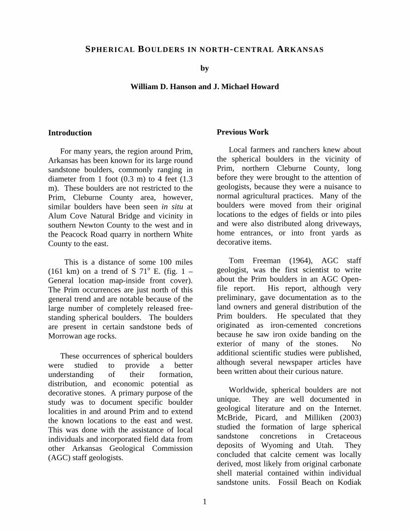
Figure 4 – A common agricultural practice is to remove boulders from pastures and to
place them in an out-of-the-way site.
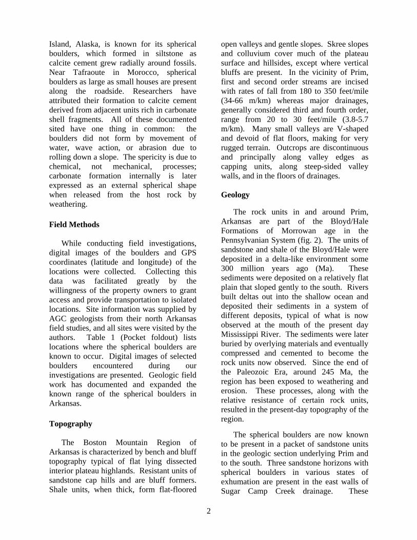
Figure 5 – A highly spherical boulder in the corner of a pasture.

6
Figure 6 – Full decorative potential recognized with this boulder.
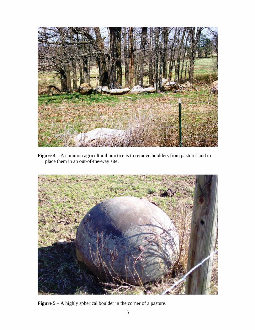
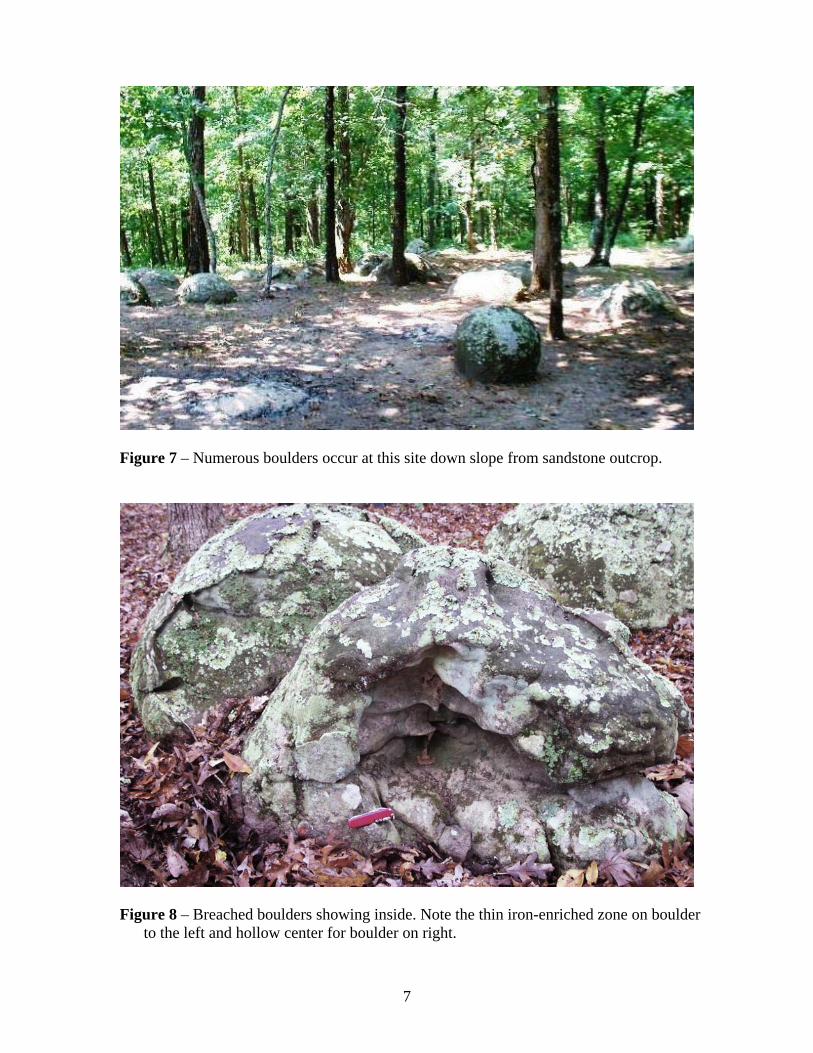
South of Prim in the NE ¼, section 13, T12N, R11W, tens to hundreds of spherical boulders are known to occur (fig. 7). A natural outcrop occurring on a gentle eroding slope has allowed numerous boulders to be readily seen. Boulders here are 1 to 3 feet (0.3 – 1.0 m) in diameter, with many of them in parts or in the process of cracking open due to weathering. The boulders which have degraded the most show more than one zone of iron enrichment and voids in areas where there is little or no cementing agent (fig. 8). This location is the
best for viewing the spherical boulders because of the numbers present, ease of access to the site, and cooperation of the land owner. In the SE ¼, section 18, T12N, R10W, several 1 to 2 foot (0.3 – 0.6 m) diameter boulders serve as yard décor. These boulders were collected from nearby fields during land clearing. When we examined this location with the landowner, we found no boulders above ground, although several did appear exposed at the ground surface (fig. 9).
7
Figure 7 – Numerous boulders occur at this site down slope from sandstone outcrop.
Figure 8 – Breached boulders showing inside. Note the thin iron-enriched zone on boulder to the left and hollow center for boulder on right.

8
Figure 9 – Top of boulder just being exposed. Note the iron-enriched zone on the left side of the boulder.
In the NE ¼, section 19, T12N, R10W, numerous spherical boulders occur in a wooded lot. This outcrop is in a natural undisturbed setting. Boulders here are 2 to 5 feet (0.6 – 1.5 m) in diameter and are sometimes found in sections or other various parts and pieces.
The southernmost known occurrence in the Prim area is along Sugar Camp Creek in sections 24 & 25, T12N, R11W along Sugar Camp Creek. Here numerous boulders occur within alluvial fans or they are in the process of weathering from the outcrop (fig. 10), all on the east side of the ravine. The boulders range in size from 1 to 7 feet (0.3 – 2.1 m) in diameter. In this area, one peanut-shaped boulder was observed among the
numerous spherical boulders (fig. 11). The boulders occur in several different intervals of sandstone along an approximately one half mile long portion of Sugar Camp Creek. In each case where spherical boulders were found on outcrop, they showed high energy sand-rich deposits above and below a lower energy sand-rich deposit. The west side of the ravine was examined and found to contain 10- to 25-foot massive sandstone beds and no thinner beds as on the eastern side. Questions remain as to why no spherical boulders have been observed on the west side of Sugar Camp Creek, but we speculate that a facies change from thinner to more massive sand units across the drainage may be responsible.

9
Figure 10 – Large spherical boulders weathering from the outcrop.
Figure 11 – Peanut-shaped boulder is the result of two concretions growing together during cementation.
10
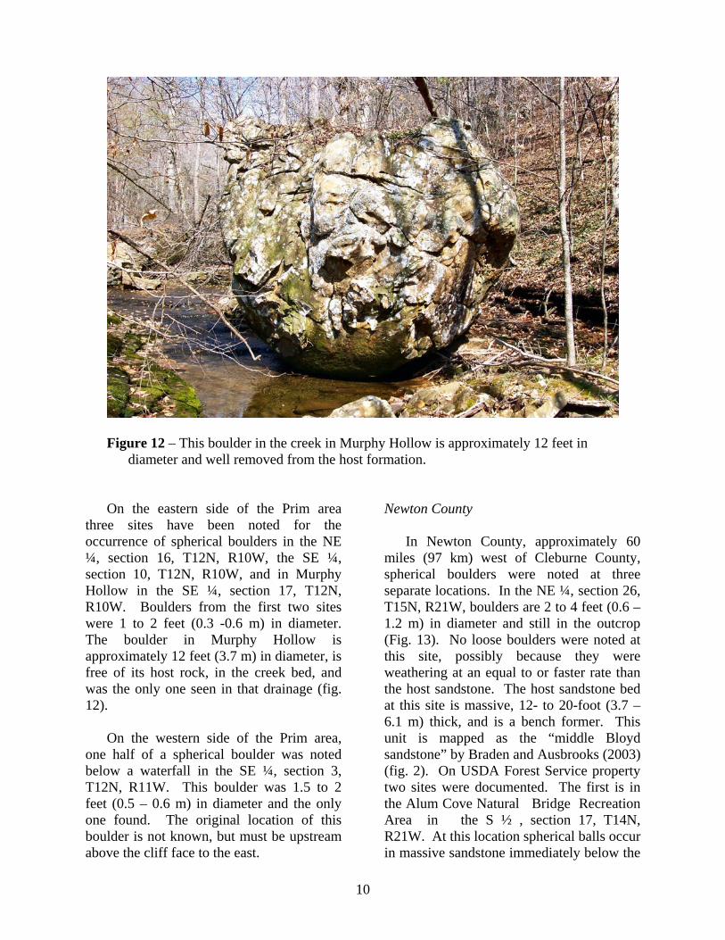
Figure 12 – This boulder in the creek in Murphy Hollow is approximately 12 feet in
diameter and well removed from the host formation.
On the eastern side of the Prim area three sites have been noted for the occurrence of spherical boulders in the NE ¼, section 16, T12N, R10W, the SE ¼, section 10, T12N, R10W, and in Murphy Hollow in the SE ¼, section 17, T12N, R10W. Boulders from the first two sites were 1 to 2 feet (0.3 -0.6 m) in diameter. The boulder in Murphy Hollow is approximately 12 feet (3.7 m) in diameter, is free of its host rock, in the creek bed, and was the only one seen in that drainage (fig. 12).
On the western side of the Prim area, one half of a spherical boulder was noted below a waterfall in the SE ¼, section 3, T12N, R11W. This boulder was 1.5 to 2 feet (0.5 – 0.6 m) in diameter and the only one found. The original location of this boulder is not known, but must be upstream above the cliff face to the east.
Newton County
In Newton County, approximately 60 miles (97 km) west of Cleburne County, spherical boulders were noted at three separate locations. In the NE ¼, section 26, T15N, R21W, boulders are 2 to 4 feet (0.6 – 1.2 m) in diameter and still in the outcrop (Fig. 13). No loose boulders were noted at this site, possibly because they were weathering at an equal to or faster rate than the host sandstone. The host sandstone bed at this site is massive, 12- to 20-foot (3.7 – 6.1 m) thick, and is a bench former. This unit is mapped as the “middle Bloyd sandstone” by Braden and Ausbrooks (2003) (fig. 2). On USDA Forest Service property two sites were documented. The first is in the Alum Cove Natural Bridge Recreation Area in the S ½ , section 17, T14N, R21W. At this location spherical balls occur in massive sandstone immediately below the

11
natural bridge (Fig. 14). No boulders were noted freed from the outcrop. The spherical masses at this location are also in the “middle Bloyd sandstone” (fig. 2). The second location is in the Farmer Cove Bluff area in the SW ¼, section 2, T14N, R21W. Here spherical balls occur in massive
sandstone beds that also contain zones of exsolved shell casts and honeycomb weathering. This is indicative of the presence of carbonate during deposition and lithification (fig. 15). This massive sandstone is the Prairie Grove Member of the Hale Formation (fig. 2).
Figure 13 – Boulders in large detrital block. Note the well developed iron-enriched zone on the boulder to the right.

12
Figure 14 – Spherical concretions weathering from host sandstone at nearly the same rate as the host rock at Alum Cove Natural Bridge.
Figure 15 – Honeycomb weathering and large spherical erosion markings in Prairie Grove
Formation at Farmer Cove Bluff.

13
White County
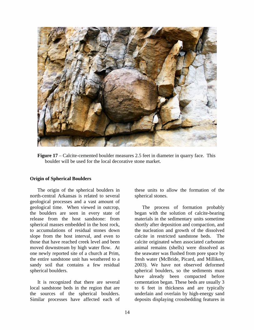
In White County, approximately 40 miles (64 km) east of Cleburne County, spherical boulders occur in an active quarry owned by Vulcan Materials Company in the SE ¼, section 27, T10N, R6W. Boulders here are spherical to elliptical in shape and range in size from 2 feet to more than 7 feet (0.6 – 2.1 m) in diameter (figs. 16, 17). They are calcite-cemented and lack the heavy iron-enrichment zone on the outer edge of the boulders as seen on the boulders
in the Prim area. The quarry operator found these boulders hard to crush and they were considered a nuisance until it was realized the more spherical boulders were sellable as decorative stones. At the time of our visit to this quarry, no loose spherical boulders were seen on site, but many complete and halves were present in the quarry walls, readily visible because of their darker coloration (light brown) when compared to the massive gray sandstone they were contained within.
Figure 16 – Calcite-cemented broken boulder measures 5 feet by 7 feet. Note that at this fresh outcrop that the boulder displays no iron-enriched zone.
14
Figure 17 – Calcite-cemented boulder measures 2.5 feet in diameter in quarry face. This boulder will be used for the local decorative stone market.
Origin of Spherical Boulders
The origin of the spherical boulders in north-central Arkansas is related to several geological processes and a vast amount of geological time. When viewed in outcrop, the boulders are seen in every state of release from the host sandstone: from spherical masses embedded in the host rock, to accumulations of residual stones down slope from the host interval, and even to those that have reached creek level and been moved downstream by high water flow. At one newly reported site of a church at Prim, the entire sandstone unit has weathered to a sandy soil that contains a few residual spherical boulders.
It is recognized that there are several local sandstone beds in the region that are the sources of the spherical boulders. Similar processes have affected each of
these units to allow the formation of the spherical stones.
The process of formation probably began with the solution of calcite-bearing materials in the sedimentary units sometime shortly after deposition and compaction, and the nucleation and growth of the dissolved calcite in restricted sandstone beds. The calcite originated when associated carbonate animal remains (shells) were dissolved as the seawater was flushed from pore space by fresh water (McBride, Picard, and Milliken, 2003). We have not observed deformed spherical boulders, so the sediments must have already been compacted before cementation began. These beds are usually 3 to 6 feet in thickness and are typically underlain and overlain by high-energy sand deposits displaying crossbedding features in

15
the vicinity of Prim. The host sandstone is generally featureless on exposure, but portions of the unit, when thicker, may display honeycombed solution-related texture. Cross-bedded spherical boulders are seen, but they are not common.
After the initial growth of the carbonate cementation, the movement of groundwater carrying dissolved iron through the host rock started an additional cementation that resulted in some iron-oxide bands and often limonite-goethite case hardening of many of the released boulders. It is notable that in the Peacock Road quarry, none of the boulders have iron-oxide banding and all are calcite-cemented. The leaching of the carbonate and formation of case-hardened iron oxide banding are due to natural processes during weathering and erosion of the enclosing sandstone unit. As groundwater in the zone of oxidation slowly moved through the host rock, it encountered differing chemical and pH conditions associated with the carbonate-cemented boulders, when compared with the host rock. The iron oxide was deposited and the carbonate removed during this chemical exchange, leaving behind the boulders we see formed in natural outcrops.
Erosion of the host sandstone slowly removes the rock face on outcrop, and the cemented boulders are left as positive features. They survive the loss of host rock due to their superior cementation, and when released, they move down slope from the outcrop face, finally reaching creek level. This type of gravity-driven system of down slope movement is a form of mass wasting and is generally more active in drier climates than presently exist in Arkansas. Greater vegetation cover holds underlying soil and loose material in place, slowing the run off of water. It is probable that many of the boulders reached their present positions some 10 thousand years ago when much of
Arkansas experienced a drier climate than today. Economic Geology
Two possibilities exist for these boulders to have some economic impact on the local region: tourism and commercial use as decorator items.
Popular tourist stops with large spherical boulders include Moreraki Beach in New Zealand and Rock City, Kansas. Large nearly spherical septarian concretions of Moeraki beach on the South Island of New Zealand eroded from mudstone cliffs along the receding beach. Rock City, southwest of Minneapolis, Kansas is a site where large spherical boulders of the early Cretaceous Dakota Sandstone exhibit cross-bedding typical of fluvial sand deposits. With proper promotion, the area around Prim may become known to tourists as a destination.
Several features of the Prim boulders are
aesthetically pleasing and, therefore, make them marketable as decorator stones: • Their overall uniform spherical shape. • Their size, most ranging from 2.5 to 3.5
feet (0.8 – 1.1 m) in diameter. • Their compactness. This property
prevents them from being broken during transport.
• Their uniqueness to the building and yard decoration trades. Only small concrete spheres and glass globes to about 15 inches (0.4 m) in diameter are available to the general public.
There appears to be as many as a
thousand or more spherical boulders in the area near Prim and a short distance to the south into Cleburne County. However, only a small percentage may be recoverable for decorator stones, simply due to the roughness of the local terrain.

16
Concentrations may be available for machine extraction at some sites, but many are presently scattered on steep slopes off the crests of local hillsides. These boulders would require more “old time” skills, like use of mules and skidders, similar to early logging efforts in the region. For such boulders, the cost of recovery would result in a higher price than those machine extracted.
Over the past 20 years, in the Prim area,
the boulders have been purchased for prices ranging from a few tens to a few hundreds of dollars, depending upon how spherical and uniform the individual boulder was. Recently, a few boulders have sold for between $400 and $800 each.
Summary
Field investigations have expanded the known area where the spherical boulders occur. This investigation extended the known range of the boulders from Newton County eastward into White County.
Although the Prim, Cleburne County, Arkansas area has the highest concentration of boulders and has the best for viewing, we now know that the spherical boulders can occur along a 100+ mile east-west trend of Morrowan-aged rocks in the northern Boston Mountains. The authors suspect at locations where no released boulders are known to occur that they are weathering as fast as or faster than the host sandstone unit. Therefore, they simply end up as part of the soil profile as loose sand grains. Only impressions of where they once were or portions left of them in the host sandstone are seen. Formation of the spherical boulders can be attributed to localized cementation of sandstone after burial, but before lithification of the unit. Investigations of the internet and in literature show that the spherical boulders found in Arkansas are not uncommon, as these types of concretions are known to occur worldwide, but they are unique in size and local abundance. The decorative stone business is taking notice of these odd natural spheres.
References Braden, A.K., 2005, Generalized
stratigraphic chart for north-central Arkansas, Arkansas Geological Commission, Open-file Report.
Braden, A.K., and Ausbrooks, S.M., 2003,
Geologic map of the Parthenon quadrangle, Newton County, Arkansas: Arkansas Geological Commission Digital Geologic Map DGM-AR-00680, scale 1:24,000, 1 sheet.
Freeman, Tom, 1964, Source and origin of spheroidal boulders, eastern Boston Mountain area, Arkansas, Arkansas Geological Commission Open-file Report, 12p.
McBride, E.F., Picard, M.D., and Milliken,
K.L., 2003, Calcite-cemented concretions in Cretaceous sandstone, Wyoming and Utah, U.S.A., Journal of Sedimentary Research, Vol. 73, No. 3, p. 462 – 483.
ii
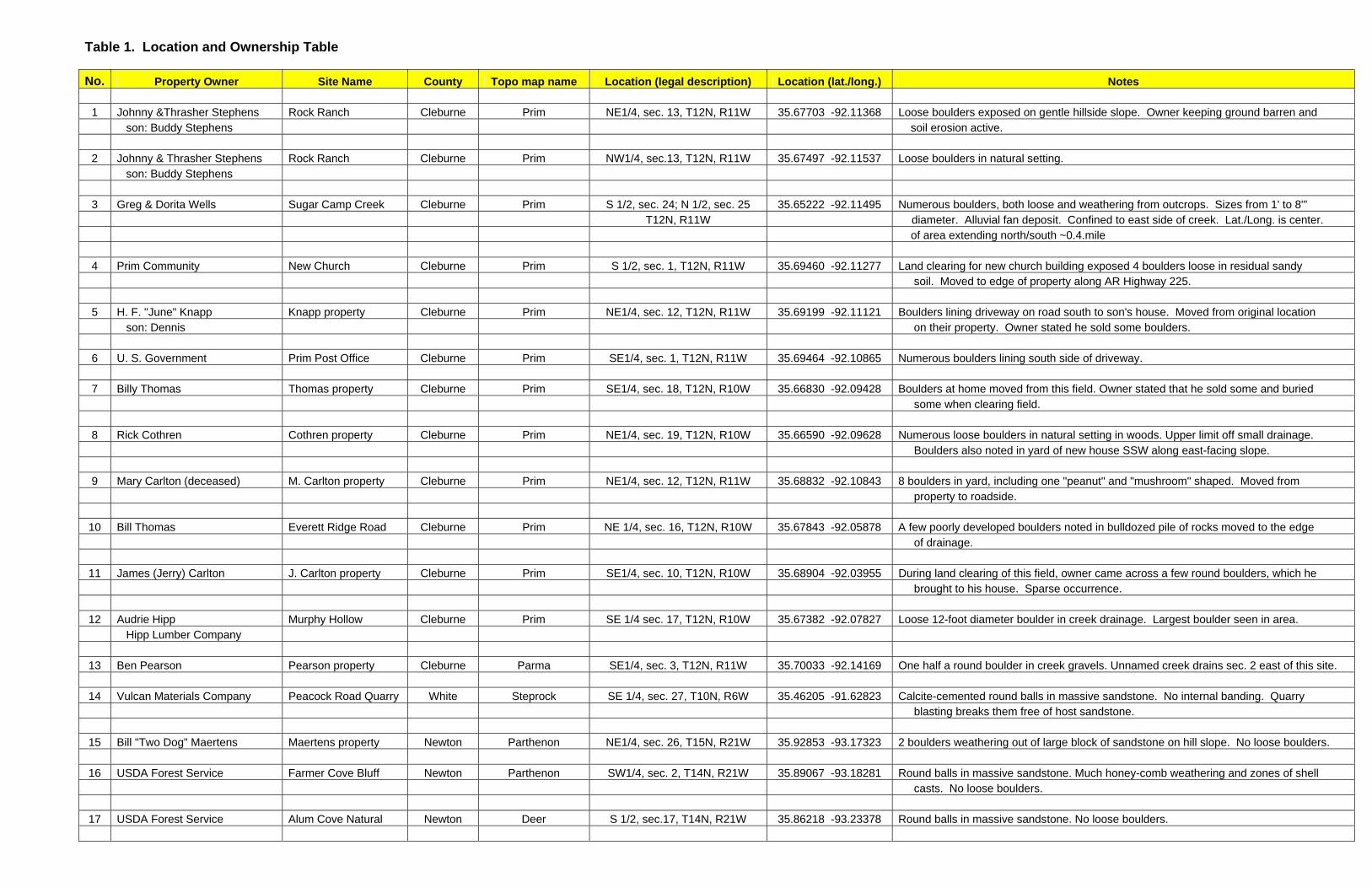
Table 1. Location and Ownership Table
No. Property Owner Site Name County Topo map name Location (legal description) Location (lat./long.) Notes 1 Johnny &Thrasher Stephens Rock Ranch Cleburne Prim NE1/4, sec. 13, T12N, R11W 35.67703 -92.11368 Loose boulders exposed on gentle hillside slope. Owner keeping ground barren and son: Buddy Stephens soil erosion active. 2 Johnny & Thrasher Stephens Rock Ranch Cleburne Prim NW1/4, sec.13, T12N, R11W 35.67497 -92.11537 Loose boulders in natural setting. son: Buddy Stephens 3 Greg & Dorita Wells Sugar Camp Creek Cleburne Prim S 1/2, sec. 24; N 1/2, sec. 25 35.65222 -92.11495 Numerous boulders, both loose and weathering from outcrops. Sizes from 1' to 8"' T12N, R11W diameter. Alluvial fan deposit. Confined to east side of creek. Lat./Long. is center. of area extending north/south ~0.4.mile 4 Prim Community New Church Cleburne Prim S 1/2, sec. 1, T12N, R11W 35.69460 -92.11277 Land clearing for new church building exposed 4 boulders loose in residual sandy soil. Moved to edge of property along AR Highway 225. 5 H. F. "June" Knapp Knapp property Cleburne Prim NE1/4, sec. 12, T12N, R11W 35.69199 -92.11121 Boulders lining driveway on road south to son's house. Moved from original location son: Dennis on their property. Owner stated he sold some boulders. 6 U. S. Government Prim Post Office Cleburne Prim SE1/4, sec. 1, T12N, R11W 35.69464 -92.10865 Numerous boulders lining south side of driveway. 7 Billy Thomas Thomas property Cleburne Prim SE1/4, sec. 18, T12N, R10W 35.66830 -92.09428 Boulders at home moved from this field. Owner stated that he sold some and buried some when clearing field. 8 Rick Cothren Cothren property Cleburne Prim NE1/4, sec. 19, T12N, R10W 35.66590 -92.09628 Numerous loose boulders in natural setting in woods. Upper limit off small drainage. Boulders also noted in yard of new house SSW along east-facing slope. 9 Mary Carlton (deceased) M. Carlton property Cleburne Prim NE1/4, sec. 12, T12N, R11W 35.68832 -92.10843 8 boulders in yard, including one "peanut" and "mushroom" shaped. Moved from property to roadside.
10 Bill Thomas Everett Ridge Road Cleburne Prim NE 1/4, sec. 16, T12N, R10W 35.67843 -92.05878 A few poorly developed boulders noted in bulldozed pile of rocks moved to the edge of drainage.
11 James (Jerry) Carlton J. Carlton property Cleburne Prim SE1/4, sec. 10, T12N, R10W 35.68904 -92.03955 During land clearing of this field, owner came across a few round boulders, which he brought to his house. Sparse occurrence.
12 Audrie Hipp Murphy Hollow Cleburne Prim SE 1/4 sec. 17, T12N, R10W 35.67382 -92.07827 Loose 12-foot diameter boulder in creek drainage. Largest boulder seen in area. Hipp Lumber Company
13 Ben Pearson Pearson property Cleburne Parma SE1/4, sec. 3, T12N, R11W 35.70033 -92.14169 One half a round boulder in creek gravels. Unnamed creek drains sec. 2 east of this site.
14 Vulcan Materials Company Peacock Road Quarry White Steprock SE 1/4, sec. 27, T10N, R6W 35.46205 -91.62823 Calcite-cemented round balls in massive sandstone. No internal banding. Quarry blasting breaks them free of host sandstone.
15 Bill "Two Dog" Maertens Maertens property Newton Parthenon NE1/4, sec. 26, T15N, R21W 35.92853 -93.17323 2 boulders weathering out of large block of sandstone on hill slope. No loose boulders.
16 USDA Forest Service Farmer Cove Bluff Newton Parthenon SW1/4, sec. 2, T14N, R21W 35.89067 -93.18281 Round balls in massive sandstone. Much honey-comb weathering and zones of shell casts. No loose boulders.
17 USDA Forest Service Alum Cove Natural Newton Deer S 1/2, sec.17, T14N, R21W 35.86218 -93.23378 Round balls in massive sandstone. No loose boulders.

ii