Speed Camera Locations - Roads and Maritime Services · Current Speed Camera Locations April 2014...
28
Current Speed Camera Locations April 2014 Fixed Speed Camera Locations Road Comment Suburb/Town www.transport.nsw.gov.au Disclaimer While all care is taken in producing this work, no responsibility is taken or warranty made with respect to the accuracy of any information, data or representation. The authors (including copyright owners) expressly disclaim all liability in respect of anything done or omitted to be done and the consequences upon reliance of the contents of this information. TfNSW M152 14.04.14 Alstonville Camera Removed Bruxner Highway, between Gap Road and Teven Road Major road works undertaken at site (Alstonville Bypass) Angledale Camera Removed Princes Highway, between Hergenhans Lane and Stony Creek Road safety works proposed. See RMS website for details. Auburn Parramatta Road, between Harbord Street and Duck Street Banora Point Camera Removed Pacific Highway, between Laura Street and Darlington Drive Major road works undertaken at site (Pacific Highway Upgrade) Bar Point F3 Freeway, between Jolls Bridge and Mt White Exit Ramp Bardwell Park / Arncliffe M5 Tunnel, between Bexley Road and Marsh Street Ben Lomond New England Highway, between Ross Road and Ben Lomond Road Berkshire Park Richmond Road, between Llandilo Road and Sanctuary Drive Berry Princes Highway, between Kangaroo Valley Road and Victoria Street Bexley North Bexley Road, between Kingsland Road North and Miller Avenue Blandford New England Highway, between Hayles Street and Mills Street Bomaderry Bolong Road, between Beinda Street and Coomea Street Bonnyrigg Elizabeth Drive, between Brown Road and Humphries Road Bonville Pacific Highway, between Bonville Creek and Bonville Station Road Brogo Princes Highway, between Pioneer Close and Brogo River Broughton Auditor-General Deactivated Princes Highway, between Austral Park Road and Gembrook Lane Road safety works proposed. See RMS website for details. Bulli Princes Highway, between Grevillea Park Road and Black Diamond Place Bundagen Camera Removed Pacific Highway, between Pine Creek and Perrys Road Major road works undertaken at site (Pacific Highway Upgrade) Burringbar Tweed Valley Way, between Blakeneys Road and Cooradilla Road Burwood Auditor-General Deactivated Hume Highway, between Willee Street and Emu Street Road safety works proposed. See RMS website for details. Burwood Heights Hume Highway, between Kelso Street and Appian Way Camellia James Ruse Drive, between Victoria Road and Grand Avenue North Canterbury Canterbury Road, between Gould Street and Jeffrey Street Caringbah Captain Cook Drive, between Cawarra Road and Gannons Road Carlingford Pennant Hills Road, between Evans Road and Coleman Avenue Charmhaven Pacific Highway, between Wallarah Creek and Lowana Avenue Clunes Warning Mode Bangalow Road, between Flatley Drive and Johnston Road Camera in warning mode and safety works proposed. See RMS website for details. Concord West Concord Road, between Nirranda Street and Mepunga Street
Transcript of Speed Camera Locations - Roads and Maritime Services · Current Speed Camera Locations April 2014...

CurrentSpeed Camera Locations
April 2014
Fixed Speed Camera Locations
Road CommentSuburb/Town
www.transport.nsw.gov.au DisclaimerWhile all care is taken in producing this work, no responsibility is taken or warranty made with respect to the accuracy of any information, data or representation. The authors (including copyright owners) expressly disclaim all liability in respect of anything done or omitted to be done and the consequences upon reliance of the contents of this information.TfNSW M152 14.04.14
Alstonville Camera Removed
Bruxner Highway, between Gap Road and Teven Road Major road works undertaken at site (Alstonville Bypass)
AngledaleCamera Removed
Princes Highway, between Hergenhans Lane and Stony Creek Road safety works proposed. See RMS website for details.
Auburn Parramatta Road, between Harbord Street and Duck Street
Banora PointCamera Removed
Pacific Highway, between Laura Street and Darlington Drive Major road works undertaken at site (Pacific Highway Upgrade)
Bar Point F3 Freeway, between Jolls Bridge and Mt White Exit Ramp
Bardwell Park / Arncliffe M5 Tunnel, between Bexley Road and Marsh Street
Ben Lomond New England Highway, between Ross Road and Ben Lomond Road
Berkshire Park Richmond Road, between Llandilo Road and Sanctuary Drive
Berry Princes Highway, between Kangaroo Valley Road and Victoria Street
Bexley North Bexley Road, between Kingsland Road North and Miller Avenue
Blandford New England Highway, between Hayles Street and Mills Street
Bomaderry Bolong Road, between Beinda Street and Coomea Street
Bonnyrigg Elizabeth Drive, between Brown Road and Humphries Road
Bonville Pacific Highway, between Bonville Creek and Bonville Station Road
Brogo Princes Highway, between Pioneer Close and Brogo River
BroughtonAuditor-General Deactivated
Princes Highway, between Austral Park Road and Gembrook Lane
Road safety works proposed. See RMS website for details.
Bulli Princes Highway, between Grevillea Park Road and Black Diamond Place
Bundagen Camera Removed
Pacific Highway, between Pine Creek and Perrys Road Major road works undertaken at site (Pacific Highway Upgrade)
Burringbar Tweed Valley Way, between Blakeneys Road and Cooradilla Road
BurwoodAuditor-General Deactivated
Hume Highway, between Willee Street and Emu Street Road safety works proposed. See RMS website for details.
Burwood Heights Hume Highway, between Kelso Street and Appian Way
Camellia James Ruse Drive, between Victoria Road and Grand Avenue North
Canterbury Canterbury Road, between Gould Street and Jeffrey Street
Caringbah Captain Cook Drive, between Cawarra Road and Gannons Road
Carlingford Pennant Hills Road, between Evans Road and Coleman Avenue
Charmhaven Pacific Highway, between Wallarah Creek and Lowana Avenue
ClunesWarning Mode
Bangalow Road, between Flatley Drive and Johnston Road Camera in warning mode and safety works proposed. See RMS website for details.
Concord West Concord Road, between Nirranda Street and Mepunga Street

CurrentSpeed Camera Locations
April 2014
Fixed Speed Camera Locations
Road CommentSuburb/Town
www.transport.nsw.gov.au DisclaimerWhile all care is taken in producing this work, no responsibility is taken or warranty made with respect to the accuracy of any information, data or representation. The authors (including copyright owners) expressly disclaim all liability in respect of anything done or omitted to be done and the consequences upon reliance of the contents of this information.TfNSW M152 14.04.14
CoolacCamera Removed
Hume Highway, between Gobarralong Road and Coggans Road
Major road works undertaken at site (Coolac Bypass & Hume Highway Duplication)
Corrimal Northern Distributor, between Towradgi Road and Railway Street
Darlinghurst Eastern Distributor , between Oxford Street and William Street
Edgecliff New South Head Road, between Waratah Street and New Beach Road
Ewingsdale Pacific Highway, between St Helena Road and Ewingsdale Road.
Fairfield East Fairfield Street, between Scott Street and Mandarin Street
Foxground Princes Highway, between Foxground Road and Broughton Creek
Frenchs Forest Auditor-General Deactivated
Warringah Road, between Hilmer Street and Fitzpatrick Avenue East
Road safety works proposed. See RMS website for details.
GordonWarning Mode
Eastern Arterial Road, between Koola Avenue and Nicholson Avenue
Camera in warning mode and safety works proposed. See RMS website for details.
Green ValleyCamera Removed
Cowpasture Road, between Seventeenth Avenue and Green Valley Road
Deactivated following 2012 Annual Speed Camera Performance review and safety review.
Greystanes Greystanes Road, between Merrylands Road and Old Prospect Road
Gwynneville Southern Freeway, between Northern Distrbutor Overpass and Gipps Road Overpass
Hartley Great Western Highway, between Mid Hartley Road and Blackmans Creek Road
Herons CreekCamera Removed
Pacific Highway, between Bobs Creek Road and Herons Creek Major road works undertaken at site (Pacific Highway Upgrade)
Hungry Head Pacific Highway, between Boundary Road and Ballards Road
Kariong Auditor-General Deactivated
Woy Woy Road, between Staples Lookout and Woy Woy Bay Road
Road safety works proposed. See RMS website for details.
KootingalCamera Removed
New England Highway, between Gill Street and Yarrol Road Deactivated following 2012 Annual Speed Camera Performance review and safety review.
Korora Pacific Highway, between Bruxner Park Road and Korora Basin Road
KundabungAuditor-General Deactivated
Pacific Highway, between Ravenswood Road and Franks Lane Road safety works proposed. See RMS website for details.
Kurrajong Bells Line of Road, between Queen Street and Bellbird Avenue
LambtonAuditor-General Deactivated
Newcastle Road, between Steel Street and Robinson Avenue Road safety works proposed. See RMS website for details.
Lane Cove Centennial Avenue, between Gentle Street and Figtree Street
Lane Cove Tunnel Lane Cove Tunnel, between Mowbray Road and Pacific Highway
Lansvale Hume Highway, between Henry Lawson Drive and Knight Street

CurrentSpeed Camera Locations
April 2014
Fixed Speed Camera Locations
Road CommentSuburb/Town
www.transport.nsw.gov.au DisclaimerWhile all care is taken in producing this work, no responsibility is taken or warranty made with respect to the accuracy of any information, data or representation. The authors (including copyright owners) expressly disclaim all liability in respect of anything done or omitted to be done and the consequences upon reliance of the contents of this information.TfNSW M152 14.04.14
Llangothlin Camera Removed
New England Highway, between Ben Lomond Road and Everetts Road
Road safety works proposed. See RMS website for details.
M2 Tunnel M2 Motorway, between Terry Creek and Norfolk Road
Macksville Pacific Highway, between Florence Wilmont Drive and Watt Creek
Macquarie ParkAuditor-General Deactivated
Delhi Road, between Julius Avenue and River Avenue Road safety works proposed. See RMS website for details.
Mascot/BotanyAuditor-General Deactivated
General Holmes Drive, between Foreshore Road and M5 East Motorway
Road safety works proposed. See RMS website for details.
Mayfield West Pacific Highway, between Werribie Street and Tourle Street
Murrurundi Auditor-General Deactivated
New England Highway, between Bernard Street and Adelaide Street
Road safety works proposed. See RMS website for details.
New Italy Pacific Highway, between New Italy Road and Turners Road
Nords Wharf Pacific Highway, between Nords Wharf Road and Flowers Drive
North Parramatta Pennant Hills Road, between Castle Street and Bellevue Street
North WilloughbyWarning Mode
Eastern Valley Way, between Megalong Avenue and McClelland Street
Camera in warning mode and safety works proposed. See RMS website for details.
North Wollongong Princes Highway, between Ajax Avenue and Exeter Avenue
NowraAuditor-General Deactivated
Princes Highway, between Moss Street and Pleasant Way Road safety works proposed. See RMS website for details.
Ocean ShoresAuditor-General Deactivated
Pacific Highway, between Banana Road and Rajah Road Road safety works proposed. See RMS website for details.
Ourimbah F3 Freeway, between Dogtrap Road Overpass and Ourimbah Creek Road
Padstow Gibson Avenue, between Turvey Street and Bryant Street
Peakhurst Henry Lawson Drive, between Belmore Road and Ogilvy Street
Picnic Point Henry Lawson Drive, between Carinya Road and The River Road
Queanbeyan Lanyon Drive, between Tompsitt Drive and Hoover Road
QuirindiCamera Removed
New England Highway, between Gaspard Road and Lowestoft Road
Road safety works proposed. See RMS website for details.
Rankin Park McCaffrey Drive, between Duval Street and Orara Street
Ryde Blaxland Road, between Reservoir Lane and North Road
Sandgate Pacific Highway, between Wallsend Road and Ironbark Creek
Scone Auditor-General Deactivated
New England Highway, between Eveleigh Circuit and Forbes Street
Road safety works proposed. See RMS website for details.
Shoalhaven HeadsAuditor-General Deactivated
Bolong Road, between Shoalhaven Heads Road and Coolangatta Road
Road safety works proposed. See RMS website for details.
South Windsor George Street, between Rickaby Street and Yarrawonga Street
Sydney Sydney Harbour Tunnel, between Cahill Expressway and Warringah Freeway

CurrentSpeed Camera Locations
April 2014
Fixed Speed Camera Locations
Road CommentSuburb/Town
www.transport.nsw.gov.au DisclaimerWhile all care is taken in producing this work, no responsibility is taken or warranty made with respect to the accuracy of any information, data or representation. The authors (including copyright owners) expressly disclaim all liability in respect of anything done or omitted to be done and the consequences upon reliance of the contents of this information.TfNSW M152 14.04.14
TarcuttaCamera Removed
Hume Highway, between Tonja Settlement Road and Dellateroi Creek
Major road works undertaken at site (Hume Highway Duplication)
Tenterfield New England Highway, between Duncan Street and George Street
The Spit/Beauty Point Warning Mode
Spit Road, between Parriwi Road and Upper Spit Road and between Central Avenue and Medusa Street
Camera in warning mode and safety works proposed. See RMS website for details.
TilbusterCamera Removed
New England Highway, between Sunnyside Road and Tilbuster Ponds Bridge
Road safety works proposed. See RMS website for details.
UrungaWarning Mode
Pacific Highway, between Ranger Street and Hillside Drive Camera in warning mode and safety works proposed. See RMS website for details.
Valla Beach Pacific Highway, between Valla Beach Road and Oyster Creek
Valley Heights Great Western Highway, between The Valley Road and Sun Valley Road
Wardell Pacific Highway, between Riverside Drive and Carlisle Street
Warrawong Northcliffe Drive, between Griffin Street and Kully Street
Wentworthville / Greystanes Auditor-General Deactivated
M4 Motorway, between Coleman Street Overpass and Cumberland Highway Overpass
Road safety works proposed. See RMS website for details.
West Gosford Auditor-General Deactivated
Manns Road, between Stockyard Place and Carnarvon Road Road safety works proposed. See RMS website for details.
West Pennant Hills Castle Hill Road, between Pennant Hills Road and Coonara Avenue
Wollongbar Bruxner Highway, between Convernys Lane and McLeans Ridges Road
Woodburn Pacific Highway, between Wagner Street and Norman Street
Woolloomooloo / East Sydney Cross City Tunnel, between McLachlan Avenue and Harbour Street
Yagoona Hume Highway, between Smith Street and Brennan Avenue

CurrentSpeed Camera Locations
April 2014
Fixed Speed Camera Locations – School Zones
Road Schools near camera/CommentSuburb/Town
www.transport.nsw.gov.au DisclaimerWhile all care is taken in producing this work, no responsibility is taken or warranty made with respect to the accuracy of any information, data or representation. The authors (including copyright owners) expressly disclaim all liability in respect of anything done or omitted to be done and the consequences upon reliance of the contents of this information.TfNSW M152 14.04.14
Ashfield Hume Highway, between Murrell Street and Queen Street
Ashfield Public School
Bankstown Hume Highway, between Rookwood Road and Stacey Street
Bankstown North Public School, La Salle Catholic School
Bateau BayAuditor-General Deactivated
The Entrance Road, between Yakalla Street and Wyong Road
Tuggerah Lakes Secondary College — The Entrance Campus Road safety works proposed. See RMS website for details.
Beverly Hills King Georges Road, between Stoney Creek Road and Edgbaston Road
Beverly Hills Girls High School
Bonnyrigg Cabramatta Road, between Katinka Street and Tarlington Parade
Bonnyrigg High School and Our Lady of Mt Carmel Primary School
Castle Hill Old Northern Road, between Telfer Road and Brisbane Road
St Bernadette’s Primary School
Condell Park Edgar Street, between Augusta Street and Upper Railway Parade
Condell Park Primary School
Eastgardens/Maroubra Bunnerong Road, between Fitzgerald Avenue and Smith Street
Marist College Pagewood
EppingWarning Mode
Carlingford Road, between Midson Road and Duntroon Ave
Epping West Public School Camera in warning mode and safety works proposed. See RMS website for details.
Fairy MeadowAuditor-General Deactivated
Balgownie Road, between Alexander Street and Princes Highway
Fairy Meadow Public School Road safety works proposed. See RMS website for details.
Gateshead Pacific Highway, between Sydney Street and Macquarie Avenue
Hunter Sports High School, Gateshead Public School, St Mary’s High School
Guildford Woodville Road, between Kenelda Avenue and Osgood Street
Granville South Public School
GymeaWarning Mode
President Avenue, between Koorabell Road and Gymea Bay South Road
St Catherine Labore Primary SchoolCamera in warning mode and safety works proposed. See RMS website for details.
Hurstville Forest Road, between Lily Street and Cronulla Street
Bethany College, Sydney Technical High School, Hurstville Boys High School and Hurstville Primary School
Kingswood Parker Street, between Copeland Street and Gascoigne Street
St Dominics College
Kogarah Princes Highway, between Gray Street and President Avenue
St Patricks Primary School, Bethany College, James Cook Boys High School, Moorefield Girls High School, Kogarah Public School
Lindfield Pacific Highway, between Eton Road and Gladstone Parade
Lindfield Primary School
Liverpool Bigge Street, between Elizabeth Drive and Campbell Street
All Saints Catholic Primary School, All Saints Catholic Girls College and All Saints Catholic Boys College
Lochinvar New England Highway, between Robert Road and Station Lane
Lochinvar Public School, St Patrick's Primary School, All Saints College — St Joseph’s Campus
Maroubra Malabar Road, between Mons Avenue and Duncan Street
St Mary & St Joseph’s Primary, Maroubra Bay
Merrylands Merrylands Road, between Chetwynd Road and Davies Street
St. Margaret Mary’s Primary School
Merrylands WestAuditor-General Deactivated
Sherwood Road, between Kenyons Road and Bristol Street
Cerdon College & Merrylands High School Road safety works proposed. See RMS website for details.

CurrentSpeed Camera Locations
April 2014
Fixed Speed Camera Locations – School Zones
Road Schools near camera/CommentSuburb/Town
www.transport.nsw.gov.au DisclaimerWhile all care is taken in producing this work, no responsibility is taken or warranty made with respect to the accuracy of any information, data or representation. The authors (including copyright owners) expressly disclaim all liability in respect of anything done or omitted to be done and the consequences upon reliance of the contents of this information.TfNSW M152 14.04.14
Miranda Kingsway, between Sylva Avenue and University Road
Port Hacking High School and Miranda Public School
Moore Park Cleveland Street, between Anzac Parade and South Dowling Street
Sydney Boys High School and Sydney Girls High School
Mosman Macpherson Street, between Ourimbah Road and Montague Road
Middle Harbour Primary School
Narrabeen Pittwater Road, between Ocean Street and Devitt Street
Narrabeen Lakes Primary School
North Curl Curl Harbord Road, between Abbott Road and Brighton Street
Freshwater Senior High School and Manly Selective Campus
North Narrabeen Pittwater Road, between Garden Street and Namona Street
Narrabeen North Public School, Narrabeen Sports High School
North Parramatta / Oatlands Pennant Hills Road, between Masons Drive and Suttor Avenue
Burnside Public School, The Kings School, Redeemer Baptist School, Garfield Barwick School, American International School, Cumberland High School
Old Guilford Woodville Road, between Orchardleigh Street and Middleton Road
Old Guildford Public School
Ourimbah Pacific Highway, between Yates Road and Dog Trap Road
Ourimbah Primary School
ParramattaAuditor-General Deactivated
Great Western Highway, between Pitt Street and Steele Street
Parramatta High School Road safety works proposed. See RMS website for details.
Penshurst Forest Road, between Penshurst Street and St Georges Street
Penshurst Girls campus – Georges River College, Penshurst Public school and St Declan’s Primary School
Randwick Avoca Street, between Howard Street and Barker Road
Randwick Boys High School, Randwick Girls High School
Rosebery/Alexandria Botany Road, between Gardeners Road and Gillespie Street
Gardeners Road Public School
Rydalmere Victoria Road, between Park Road and John Street
Rydalmere Public School
Ryde Victoria Road, between Margaret Street and Cressy Road
Holy Cross College Ryde and St Charles School Ryde
Strathfield The Boulevarde, between Torrington Parade and Russell Street
Trinity Grammar Preparatory School, Santa Sabina College, Santa Maria Del Monte, Meriden Senior and Junior
Terrigal Terrigal Drive, between Brunswick Road and Bellbird Avenue
Terrigal High School
Toongabbie Fitzwilliam Road, between Reynolds Street and Binalong Road
Toongabbie Public School
Wahroonga Pacific Highway, between Gilda Avenue and Woodville Avenue
Warrawee Public School, Knox Grammar, Abbotsleigh Senior Campus
Wollongong Princes Highway, between Mount Keira Road and Highway Avenue
Illawarra Grammar School, Wollongong Public School, St Theresa Primary School
Woy Woy NorthAuditor-General Deactivated
Blackwall Road, between Park Road and Bowden Road
Woy Woy Public School Road safety works proposed. See RMS website for details.
Woy Woy Auditor-General Deactivated
Ocean Beach Road, between Waterloo Avenue and Balaclava Ave
Woy Woy South Public School oad safety works proposed. See RMS website for details.
Wyoming Henry Parry Drive, between Glennie Street and Dwyer Street
Our Lady of the Rosary Primary School

CurrentSpeed Camera Locations
April 2014
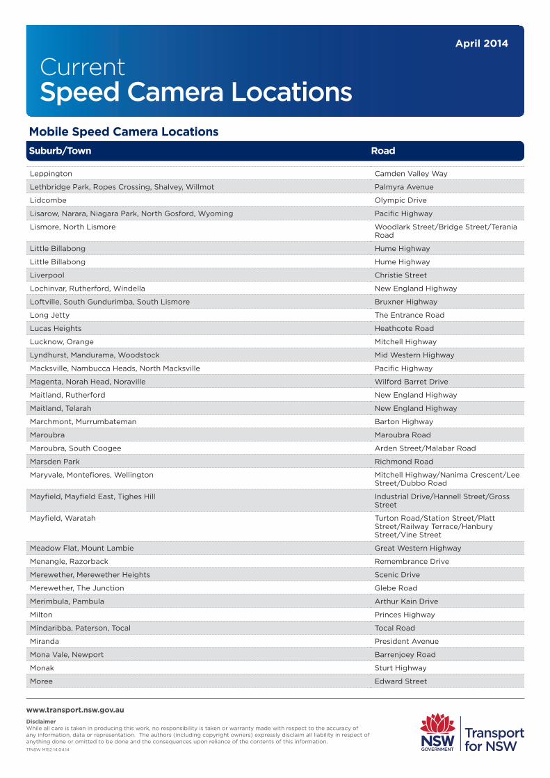
Mobile Speed Camera Locations
www.transport.nsw.gov.au DisclaimerWhile all care is taken in producing this work, no responsibility is taken or warranty made with respect to the accuracy of any information, data or representation. The authors (including copyright owners) expressly disclaim all liability in respect of anything done or omitted to be done and the consequences upon reliance of the contents of this information.TfNSW M152 14.04.14
RoadSuburb/Town
Aarons Pass, Apple Tree Flat, Cudgegong, Ilford Mid Western Highway
Aberdare, Cessnock, Neath Cessnock Road
Aberdeen, Muswellbrook New England Highway
Aberdeen, Scone, Segenhoe New England Highway
Acacia Gardens, Glenwood, Kings Langley, Kings Park Sunnyholt Road
Adamstown Heights, Merewether City Road (Pacific Highway)
Adamstown, Hamilton South Glebe Road
Albion Park Rail, Croom Princes Highway
Albion Park, Albion Park Rail, Macquarie Pass, North Macquarie, Tongarra, Tullimbar Illawarra Highway
Albion Park, Croom Terry Street/Jamberoo Road
Alectown Newell Highway
Alexandria, Beaconsfield, Chippendale, Haymarket, Redfern, Rosebery, Waterloo, Zetland Botany Road/Gibbons Street/Regent Street/Henderson Road
Alexandria, Eastlakes, Mascot, Rosebery Gardeners Road
Alfords Point, Menai Alfords Point Road
Alfredtown, East Wagga Wagga, Forest Hill, Gumly Gumly Sturt Highway
Allambie Heights, Balgowlah, Brookvale, Manly Vale, North Balgowlah, North Manly Condamine Road
Allandale, Greta, Harpers Hill, Lochinvar New England Highway
Alleena, Ariah Park, Beckom, Mirrool Newell Highway
Alleena, West Wyalong Newell Highway
Alstonville, Uralba, Wollongbar Bruxner Highway
Ambarvale, Bradbury, Campbelltown, Rosemeadow, St Helens Park Appin Road
Anna Bay, Salamander Bay, Taylors Beach Port Stephens Drive
Annandale, Camperdown, Leichhardt, Petersham, Stanmore Parramatta Road
Appin, Cataract Appin Road
Appin, Wilton Wilton Road
Apsley, Clergate, Dripstone, Euchareena, Kerrs Creek, March, Mullion Creek, Mumbil, Orange, Stuart Town
Burrendong Way
Apsley, Wellington Mitchell Highway/Molong Road/Arthur Street/Maughan Street
Ardlethan, Barellan, Kamarah, Moombooldool Temora-Yenda Road
Argenton Lake Road
Argyle, Armidale, Hillgrove Waterfall Way
Armatree, Coonamble, Curban, Gilgandra, Gulargambone Castlereagh Highway
Armidale Waterfall Way
Armidale, Black Mountain, Tilbuster New England Highway
Armidale, Saumarez New England Road
Arncliffe, Banksia, Rockdale Princes Highway

CurrentSpeed Camera Locations
April 2014
Mobile Speed Camera Locations
www.transport.nsw.gov.au DisclaimerWhile all care is taken in producing this work, no responsibility is taken or warranty made with respect to the accuracy of any information, data or representation. The authors (including copyright owners) expressly disclaim all liability in respect of anything done or omitted to be done and the consequences upon reliance of the contents of this information.TfNSW M152 14.04.14
RoadSuburb/Town
Arncliffe, Bexley Forest Road
Arndell Park, Blacktown, Doonside, Eastern Creek, Huntingwood Great Western Highway
Arndell Park, Doonside Knox Road
Arrawarra Headland, Mullaway, Safety Beach, Sandy Beach, Woolgoolga Pacific Highway
Ashfield, Dulwich Hill, Lewisham, Summer Hill Old Canterbury Road
Ashfield, Haberfield, Summer Hill Parramatta Road
Ashmont, Glenfield Park, Mount Austin Fernleigh Road
Ashtonfield, East Maitland New England Highway
Ashtonfield, Thornton New England Highway
Auburn Park Road
Auburn, Berala, Chester Hill, Regents Park, Sefton Waldron Road/Carlingford Road/Park Road
Auburn, Clyde, Granville, Harris Park M4 Motorway
Austinmer, Coledale, Wombarra Lawrence Hargrave Drive
Austinmer, Thirroul Lawrence Hargrave Drive
Austral Eden, Hampden Hall, Pola Creek South West Rocks Road
Austral, Kemps Creek, Middleton Grange, Rossmore, West Hoxton Fifteenth Avenue
Avonside, Berridale Kosciuszko Road
Awaba, Ryhope Cessnock Road
Baan Baa, Boggabri Kamilaroi Highway
Baan Baa, Narrabri, Turrawan Kamilaroi Highway
Back Forest, Coolangatta Bolong Road
Bagnoo, Doyles River, Ellenborough, Hartys Plains, Hyndmans Creek, Long Flat, Mount Seaview, Walcha, Yarras, Yarrowitch
Oxley Highway
Bald Hills, Millingandi, Pambula Millingandi Bypass
Bald Nob, Cangai, Eatonsville, Gibraltar Range, Glen Elgin, Glen Innes, Jackadgery, Moogem, Ramornie, Shannon Vale, South Grafton, Waterview, Waterview Heights
Gwydir Highway/Ryan Street
Balgowlah Sydney Road
Balgownie, Cataract, Keiraville, Mount Keira, Mount Ousley, Mount Pleasant, Tarrawanna Mount Ousley Road
Balickera, Eagleton, Ferodale, Karuah, Twelve Mile Creek Pacific Highway
Ballimore, Barbigal, Beni, Dubbo, Dunedoo, Elong Elong, Gollan, Medway, Mugga Downs, Muronbung
Golden Highway
Ballina, Cumbalum, Tintenbar, West Ballina Tamarind Drive
Ballina, Pimlico, Uralba, West Ballina Pacific Highway / River Street / Kerr Street / Tamarind Drive
Bandon, Cowra, Cumbijowa, Forbes, Gooloogong Lachlan Valley Way
Bangalow, Coorabell, Ewingsdale, McLeods Shoot, Newrybar, Tyagarah Pacific Highway
Bangor, Menai, Sutherland, Woronora Bangor Bypass/River Road/Linden Street
Banksmeadow, Botany Foreshore Road

CurrentSpeed Camera Locations
April 2014
Mobile Speed Camera Locations
www.transport.nsw.gov.au DisclaimerWhile all care is taken in producing this work, no responsibility is taken or warranty made with respect to the accuracy of any information, data or representation. The authors (including copyright owners) expressly disclaim all liability in respect of anything done or omitted to be done and the consequences upon reliance of the contents of this information.TfNSW M152 14.04.14
RoadSuburb/Town
Bankstown, Condell Park, Yagoona Edgar Street
Banora Point Darlington Drive
Banora Point, Terranora Terranora Road
Banyabba, Clifden, Dilkoon, Gurranang, Mountain View, Warragai Creek Summerland Way
Bar Beach, Merewether Scenic Drive/Memorial Drive
Bar Point, Calga, Cheero Point, Mooney Mooney, Mooney Mooney Creek, Mount White Pacific Highway
Baradine, Bugaldie, Coonabarabran, Coonamble, Nebea, Pine Grove, Teridgerie Baradine-Coonamble-Coonabarabran Road
Barellan, Bilbul, Binya, Yenda, Yoogali Temora-Yenda Road
Bargo Remembrance Drive
Barmedman, Gidginbung, Reefton, Temora Temora-Barmedman Road
Barmedman, Wyalong Barmedman-West Wyalong Road
Barrack Heights, Blackbutt, Flinders, Shellharbour, Shellharbour City Wattle Road
Barrack Heights, Dunmore, Flinders, Shell Cove, Shellharbour Shellharbour Road
Barrack Heights, Lake Illawarra, Warilla Shellharbour Road
Barrack Heights, Mount Warrigal, Oak Flats, Shellharbour City, Warilla Lake Entrance Road
Barraganyatti, Clybucca, Eungai Rail Pacific Highway
Barrengarry Mona Vale Road
Barrengarry, Fitzroy Falls Mona Vale Road
Barrington, Baxters Ridge, Bowman, Bretti, Giro, Gloucester, Mares Run, Nowendoc, Rookhurst, Tibbuc, Walcha
Thunderbolts Road
Basin View, Falls Creek, Tomerong Princes Highway
Bass Hill, Lansdowne, Villawood Hume Highway
Bateau Bay, Berkeley Vale, Glenning Valley, Killarney Vale, Long Jetty, Tumbi Umbi Wyong Road
Batemans Bay, Mogo Princes Highway
Bathurst, Dunkeld, Evans Plains, Mitchell, Robin Hill, Stewarts Mount, West Bathurst, Windradyne
Mitchell Highway
Bathurst, Kelso Great Western Highway
Baulkham Hiils, Seven Hills, Winston Hills Old Windsor Road
Baulkham Hills, Castle Hill Old Northern Road
Beaumont Hills, Kellyville, Kellyville Ridge, Stanhope Gardens Windsor Road
Beemunnel, Collie, Gilgandra, Nevertire, Ravenswood, Red Hill, Snakes Plain, Tenandra, Warren
Kamilaroi Highway
Bega Princes Highway/Carp Street/Gipps Street/Newtown Road
Belfield, Belmore, South Strathfield, Strathfield Homebush Road/Burwood Road
Belford, Branxton, East Branxton, Lower Belford New England Highway
Belford, Singleton, Whittingham New England Highway
Bell, Blue Mountains National Park Bells Point of Road
Bellambi Bellambi Lane
Bellambi, Corrimal Rothery Street

CurrentSpeed Camera Locations
April 2014
Mobile Speed Camera Locations
www.transport.nsw.gov.au DisclaimerWhile all care is taken in producing this work, no responsibility is taken or warranty made with respect to the accuracy of any information, data or representation. The authors (including copyright owners) expressly disclaim all liability in respect of anything done or omitted to be done and the consequences upon reliance of the contents of this information.TfNSW M152 14.04.14
RoadSuburb/Town
Bellbird, Greta Main, Millfield, Pelton Wollombi Road
Bellimbopinni, Clybucca, Frederickton, Kempsey, Seven Oaks Pacific Highway
Bellingen, Fernmount, Raleigh Waterfall Road
Bellingen, Thora Waterfall Way
Belmont Croundace Bay Road/Ross Street/Brooks Parade
Belmont South, Blacksmiths, Little Pelican, Marks Point, Pelican Pacific Highway
Belrose, Ku-Ring-Gai Chase, St Ives, Terrey Hills Mona Vale Road
Ben Bullen, Cullen Bullen Castlereagh Highway
Ben Lomond, Glencoe, Glen Innes, Llangothlin, Stonehenge New England Highway
Benandarah, East Lynne Princes Highway
Benandarah, North Batemans Bay Princes Highway
Bendemeer, Kentucky, Uralla New England Highway
Bendemeer, Moonbi New England Highway
Bendick Murrell, Cowra, Crowther, Koorawatha, Wattamondara, Young Olympic Highway
Bennetts Green, Windale Pacific Highway
Berambing, Bilpin Bells Line of Road
Beresfield John Renshaw Drive
Beresfield, Black Hill John Renshaw Drive
Beresfield, Thornton New England Highway
Bergalia, Moruya Princes Highway
Berkeley, Brownsville, Dapto, Kanahooka, Kembla Grange, Unanderra, Yallah F6 Freeway
Berkeley, Kembla Grange, Lake Heights Northcliffe Drive
Berkeley, Unanderra Nolan Street
Berremangra, Bookham, Coolac, Jugiong Hume Highway
Berry, Gerroa Crooked River Road
Bethungra, Illabo, Junee, Marinna, Wantiool Olympic Highway
Beverley Park, Blakehurst, Carlton, Carss Park, Kogarah Bay Princes Highway
Beverley Park, Kogarah, Ramsgate, Sans Souci Rocky Point Road
Beverly Hills, Earlwood, Kingsgrove, Roselands Moorefields Road/Kingsgrove Road/William Street/
Bexhill, Howards Grass, Lagoon Grass, Richmond Hill Lismore - Bangalow Road
Bidwill, Hassall Grove, Lethbridge Park, Oakhurst, Shalvey Luxford Road
Billinudgel, Brunswick Heads, Ocean Shores, Tyagarah Pacific Highway
Binalong, Galong, Harden Burley Grifin Way
Biraganbil, Galambine, Goolma, Gulgong, Mebul Guntawang Road/Goolma Road
Black Mountain, Guyra New England Highway
Blackheath Great Western Highway
Blackheath, Medlow Bath Great Western Highway

CurrentSpeed Camera Locations
April 2014
Mobile Speed Camera Locations
www.transport.nsw.gov.au DisclaimerWhile all care is taken in producing this work, no responsibility is taken or warranty made with respect to the accuracy of any information, data or representation. The authors (including copyright owners) expressly disclaim all liability in respect of anything done or omitted to be done and the consequences upon reliance of the contents of this information.TfNSW M152 14.04.14
RoadSuburb/Town
Blacktown Main St
Blacktown, Prospect Great Western Highway
Blacktown, Prospect Reservoir Road
Blakebrook, Booerie Creek, Goolmangar, Koonorigan Nimbin Road
Blakehurst, South Hurstville King Georges Road
Blaxland, Glenbrook, Warrimoo Great Western Highway
Blayney Mid Western Highway
Blue Haven, Charmhaven, Doyalson, Lake Haven, San Remo Pacific Highway
Blue Knob, Mount Burrell Lismore-Murwillumbah Road
Blue Vale, Boggabri, Emerald Hill, Gunnedah Kamilaroi Highway
Boambee, Boambee East, Bonville, Coffs Harbour, North Boambee Valley Pacific Highway
Bodalla Princes Highway
Bogan Gate, Condobolin, Derriwong, Ootha, Yarrabandai Henry Parkes Way
Boggabilla, Moree, Tulloona Newell Highway
Bohena Creek, Coonabarabran, Dandry, Jacks Creek, Narrabri, The Pilliga Newell Highway
Bohena Creek, Narrabri Newell Highway
Bolong, Bomaderry Bolong Road
Bom Bom, Braunstone, Lanitza Orara Way
Bomaderry Princes Highway
Bomaderry, Cambewarra Cambewarra Road
Bombira, Buckaroo, Eurunderee, Milroy, Mudgee, Putta Bucca Ulan Road/Short Street/Douro Street
Bomen, Brucedale, Cartwrights Hill, Downside, Old Junee, Wallacetown, Yathella Olympic Highway
Bondi Junction, Kingsford, Queens Park, Randwick, Waverley Avoca Road
Bonnells Bay, Brightwaters, Morisset Fishery Point Road
Bonny Hills, Grants Beach, Lake Cathie, Lake Innes, North Haven, Port Macquarie Ocean Drive
Bonny Hills, Jolly Nose, Lake Cathie, Lake Innes Houston Mitchell Drive
Bonville, Bundagen, Raleigh, Repton, Valery Pacific Highway
Bookham, Bowning Hume Highway
Boorowa, Godfreys Creek Lachlan Valley Way
Boree, Manildra, Parkes Henry Parkes Way
Bourkelands, Glenfield Park, Lloyd, Tatton Red Hill Road
Bourkelands, Mount Austin, Tolland, Turvey Park Bourke Street
Bowenfels, Marrangaroo Great Western Highway
Bowenfels, South Bowenfels, South Littleton Great Western Highway
Bowral, Burradoo, Mittagong Mona Vale Road
Boxers Creek, Brisbane Grove, Goulburn Hume Highway
Boxers Creek, Carrick, Marulan Hume Highway
Braemar, Mittagong Old Hume Highway

CurrentSpeed Camera Locations
April 2014
Mobile Speed Camera Locations
www.transport.nsw.gov.au DisclaimerWhile all care is taken in producing this work, no responsibility is taken or warranty made with respect to the accuracy of any information, data or representation. The authors (including copyright owners) expressly disclaim all liability in respect of anything done or omitted to be done and the consequences upon reliance of the contents of this information.TfNSW M152 14.04.14
RoadSuburb/Town
Braidwood Kings Highway/Lascelles Street/Wallace Street/Solus Street
Branxton, Greta New England Highway
Bredbo, Colinton Monaro Highway
Brighton Le Sands, Rockdale Bay Street
Brisbane Grove, Goulburn Clinton Street/Sloane Street/Braidwood Road
Broadmeadow, Hamilton North, Lambton Griffiths Road
Broadmeadow, New Lambton Lambton Road
Broadwater, East Wardell, Wardell Pacific Highway
Broadwater, Rileys Hill, Woodburn Pacific Highway
Brocklehurst, Dubbo Newell Highway
Brogo Princes Highway
Broken Head, Byron Bay, Suffolk Park Broken Head Road
Broken Head, Lennox Head Broken Head Road
Brookfield, Clarence Town Clarence Town Road
Brookfield, Wirragulla Clarence Town Road
Brookvale, Curl Curl, Dee Why, Freshwater, North Curl Curl, North Manly Harbord Road
Broughton Village, Gerringong, Toolijooa, Willow Vale Princes Highway
Brundee, Pyree, Worrigee Greenwell Point Road
Buckenbowra, Currowan Kings Highway
Budgewoi, Budgewoi Peninsula, Lake Munmorah Elizabeth Bay Drive
Budgewoi, Buff Point, Colongra, Halekulani, San Remo Budgewoi Road
Bulahdelah, Nerong Pacific Highway
Bullaburra, Lawson, Wentworth Falls Great Western Highway
Bullarah, Collarenebri, Moree Kamilaroi Highway
Bulli, Cataract Mount Ousley Road
Bulli, Cataract, Maddens Plains, Thittoul Princes Highway
Bumbaldry, Cowra, Grenfell Mid Western Highway
Bungendore Kings Highway
Buronga, Curlwaa, Dareton, Wentworth Silver City Highway
Buronga, Gol Gol, Monak Sturt Highway
Burrabadine, Dubbo, Whylandra Mitchell Highway
Burradoo, Moss Vale Moss Vale Road/Argyle Street
Burrill Lake Princes Highway
Burrill Lake, Ulladulla Murramerrang Street/Princes Highway
Burrundulla, Menah, Mudgee Castlereagh Highway/Market Street/Douro Street/Horatio Street
Burwood Burwood Road
Burwood, Concord, Croydon, Five Dock Parramatta Road

CurrentSpeed Camera Locations
April 2014
Mobile Speed Camera Locations
www.transport.nsw.gov.au DisclaimerWhile all care is taken in producing this work, no responsibility is taken or warranty made with respect to the accuracy of any information, data or representation. The authors (including copyright owners) expressly disclaim all liability in respect of anything done or omitted to be done and the consequences upon reliance of the contents of this information.TfNSW M152 14.04.14
RoadSuburb/Town
Burwood, Concord, Homebush, North Strathfield, Strathfield Parramatta Road
Bushells Ridge, Jilliby, Kiar, Wallarah F3 - Sh10 Connection Road
Byron Bay Bangalow Road
Cabramatta, Cabramatta West, Canley Heights, Fairfield West Cumberland Highway
Cabramatta, Cabramatta West, Mount Pritchard Cabramatta Road
Calala, Hillvue, Kingswood, South Tamworth, Timbumburi Goonoo Goonoo Road
Calala, South Tamworth Calala Lane
Calga, Peats Ridge Peats Ridge Road
Camden, Elderslie, Kirkham, Narellan Cambden Valley Way
Cameron Park, Edgeworth Mimmi Road
Cameron Park, Edgeworth, Holmesville, West Wallsend Main Road
Cammeray, Crows Nest, Neutral Bay, North Sydney Falcon Street
Campbelltown, Glen Alpine, Menangle Park Menangle Road/Tindall Street/Kellicar Road
Campbelltown, Leumeah, Minto, Woodbine Campbelltown Road
Camperdown, Chippendale, Forest Lodge, Glebe, Ultimo Parramatta Road
Campvale, Ferodale, Raymond Terrace, Salt Ash Richardson Road
Canada Bay, Concord, Concord West Lyons Road/Crane Street/Majors Bay Road/Norman Street/Nullawarra Avenue/Hospital Road
Canada Bay, Concord, Five Dock Gipps Street
Canowindra Grenfell-Orange Road/Rodd Street/Ferguson Street/Tilga Street/Lynn Street/Cowra-Canowindra Road
Canterbury, Hurlstone Park Canterbury Road
Capertree, Round Swamp Castlereagh Highway
Cardiff, Cardiff Heights, New Lambton Heights Main Road
Cardiff, Cardiff South, Macquarie Hills Macquarie Road
Cardiff, Garden Suburb Myall Road
Carlingford, Epping Carlingford Road
Carrathool, Darlington Point, Hay South Sturt Highway
Carrs Creek, Grafton, Junction Hill Richmond Road/Casino Road
Cartwright, Hinchinbrook, Hoxton Park, Miller, Prestons Hoxton Park Road
Cartwright, Liverpool, Lurnea, Prestons Hoxton Park Road
Casino, Clovass, Irvington, McKees Hill, South Gundurimba Bruxner Highway
Casino, Naughtons Gap Naughtons Gap Road
Cassilis, Uarbry Golden Highway
Castle Hill Showground Rd
Casula Hume Highway
Casula, Liverpool Hume Highway
Cataract, Darkes Forest, Maddens Plains F6 Freeway

CurrentSpeed Camera Locations
April 2014
Mobile Speed Camera Locations
www.transport.nsw.gov.au DisclaimerWhile all care is taken in producing this work, no responsibility is taken or warranty made with respect to the accuracy of any information, data or representation. The authors (including copyright owners) expressly disclaim all liability in respect of anything done or omitted to be done and the consequences upon reliance of the contents of this information.TfNSW M152 14.04.14
RoadSuburb/Town
Catherine Field, Currans Hill, Harrington Park, Narellan, Oran Park, Smeaton Grange Camden Valley Road
Cattai, South Maroota Wisemans Ferry Road
Centennial Park, Woollahra Oxford Street
Cessnock Cessnock Road/Maitland Road
Charlestown, Hillsborough, Warners Bay Hillsborough Road
Charmhaven, Hamlyn Terrace, Kanwal, Lake Haven, Woongarrah Pacific Highway
Chatsworth, Harwood, James Creek, Maclean Pacific Highway
Cherrybrook, Dural New Line Rd
Chinderah, Cudgen, Stotts Creek Pacific Highway
Chipping Norton, Milperra, Moorebank Newbridge Rd
Chisholm, East Maitland, Thornton Raymond Terrace Road
Claremont Meadow, Kingswood, St Marys Great Western Highway
Clarence, Corney Town, Vale of Clwydd Bell-Bowenfells Road
Clarenza, Swan Creek, Ulmarra Pacific Highway
Clothiers Creek, Cudgera Creek, Round Mountain, Tanglewood Pacific Highway
Clothiers Creek, Duranbah, Eviron, Stotts Creek Pacific Highway
Coffs Harbour, Korora, Moonee Beach, Sapphire Beach Pacific Highway
Coffs Harbour, Toormina Hogbin Drive
Collaroy Pittwater Road
Colo Vale, Hill Top Wilson Drive
Colyton, Eastern Creek, Minchinbury, Mount Druitt, Oxley Park, Rooty Hill Great Western Highway
Colyton, Oxley Park, St Marys Great Western Highway
Comberton, Falls Creek, Nowra Hill Princes Highway
Comberton, Wollumboola Forest Road
Concord West, Rhodes Concord Road
Condong, Eviron, South Murwillumbah Tweed Valley Way
Coniston, Cringila, Port Kembla, Spring Hill, Wollongong Springhill Road
Coniston, Mount Saint Thomas, Wollongong Gladstone Avenue
Conjola, Mondayong, Twelve Mile Peg Princes Highway
Coolgardie, Pimlico, Wardell Pacific Highway
Coolongolook Pacific Highway
Coonabarabran Newell Highway, John Street, Chappell Avenue
Coonamble, Walgett, Wingadee Castlereagh Highway
Cooranbong Freemans Drive
Cooranbong, Morisset Freemans Drive
Cootamundra Adams Street
Cootamundra Mackay Street
Cootamundra Thompson Street

CurrentSpeed Camera Locations
April 2014
Mobile Speed Camera Locations
www.transport.nsw.gov.au DisclaimerWhile all care is taken in producing this work, no responsibility is taken or warranty made with respect to the accuracy of any information, data or representation. The authors (including copyright owners) expressly disclaim all liability in respect of anything done or omitted to be done and the consequences upon reliance of the contents of this information.TfNSW M152 14.04.14
RoadSuburb/Town
Cootamundra, Wallendbeen Burley Griffin Way
Cordeaux Heights, Figtree, Kembla Heights, Mount Kembla, Unanderra Cordeaux Road
Cordeaux Heights, Figtree, Unanderra Central Road
Corindi Beach, Dirty Creek, Halfway Creek Pacific Highway
Corowa Redlands Road
Corrimal, Fairy Meadow, Fernhill, Russell Vale, Towradgi Princes Highway
Corrimal, Towradgi Towradgi Road
Cowper, Ulmarra Pacific Highway
Cowra Mid Western Highway/Bahurst Road/Lynch Street/Kendall Street
Cowra Mid Western Highway/Kendall Street/Grenfell Road
Crabbes Creek, Mooball, Sleepy Hollow, Wooyung Pacific Highway
Crackenback, Kosciuszko National Park Alpine Way
Cranebrook, Llandilo The Northern Road
Crangan Bay, Frazer Park, Freemans, Lake Munmorah, Moonee, Wybung Pacific Highway
Cremorne, Mosman, Neutral Bay Military Road
Crestwood, Queanbeyan, Queanbeyan West Ross Road
Cringila, Port Kembla, Spring Hill Five Islands Road
Cringila, Spring Hill, Unanderra Five Islands Road
Cromer, Ingleside, Oxford Falls Wakehurst Parkway
Cronulla, Woolooware The Kingsway
Croom, Curramore, Jamberoo Jamberoo Road
Crosslands, Wauchope, Yippin Creek Pembrooke Road
Culcairn Olympic Highway
Culcairn, Henty Olympic Highway
Dalwood, Meerschaum Vale, Wardell Wardell Road
Dapto Princes Highway
Dapto, Horsley Bong Bong Road
Dapto, Koonawarra Fowlers Road
Darawank, Hallidays Point, Rainbow Flat, Tuncurry The Lakes Way
Darawank, Tuncurry, Wallis Lake The Lakes Way
Darkes Forest, Helensburgh, Maddens Plains, Stanwell Tops, Waterfall, Woronora Dam F6 Freeway
Darlington, Dunolly, Gowrie, McDougalls Hill, Rixs Creek, Singleton Heights New England Highway
Dean Park, Doonside, Glendenning, Oakhurst, Quakers Hill Richmond Road
Deep Creek, Skillion Flat Kempsey-Wollombi Road
Denham Court, Glenfield, Ingleburn, Varroville Hume Highway
Denistone, Denistone East, Ryde Blaxland Road
Denman Golden Highway

CurrentSpeed Camera Locations
April 2014
Mobile Speed Camera Locations
www.transport.nsw.gov.au DisclaimerWhile all care is taken in producing this work, no responsibility is taken or warranty made with respect to the accuracy of any information, data or representation. The authors (including copyright owners) expressly disclaim all liability in respect of anything done or omitted to be done and the consequences upon reliance of the contents of this information.TfNSW M152 14.04.14
RoadSuburb/Town
Dirty Creek, Halfway Creek, Wells Crossing Pacific Highway
Donnellyville, Macksville, Warrell Creek, Way Way Pacific Highway
Doonbah, Evans Head, Woodburn Alfred Road
Doonside Knox Road
Douglas Park, Menangle Menangle Road
Doyalson North, Mannering Park Ruttleys Road
Doyalson, Doyalson North, Lake Munmorah Pacific Highway
Drummoyne Lyons Road
Drummoyne, Five Dock, Russel Lea Lyons Road
Dubbo Brisbane Street
Dubbo Cobbora Road/Dunedoo Road
Dubbo Macquarie Street
Dubbo Wingewarra Street
Dumaresq Island, Glenthorne, Pampoolah Pacific Highway
Dundas, Oatlands, Parramatta, Rydalmere, Telopea Kissing Point Road
Dunedoo Golden Highway
Dunedoo, Mendooran, Merrygoen Castlereagh Highway
Dungay, Kynnumboon, Murwillumbah Queensland Border Road
Dungowan, Piallamore Nundle Road
Dunkeld, The Rocks Mitchell Highway
Dunmore, Jamberoo, Kiama Downs Princes Highway
Dunolly, Singleton, Whittingham New England Highway
Dural, Glenorie, Middle Dural Old Northern Road
E. Lismore, Girards Hill, Goonellabah, Lindendale, Lismore, Richmond Hill, S. Lismore, Wollongbar
Bruxner Highway
Earlwood Homer Street
East Coraki, Green Forest, Tucki Tucki, Tuckurimba Wyrallah Road
East Gosford, Point Frederick York Street
East Hills, Milperra, Panania Henry Lawson Drive
East Jindabyne, Jindabyne Kosciuszko Road
East Kempsey, Kempsey, Kundabung, South Kempsey Pacific Highway
East Kurrajong, Wilberforce The Putty Road
East Lismore, Girards Hill, Monaltrie, Wyrallah Wyrallah Road
East Maitland, Maitland, South Maitland New England Highway
East Tamworth, Nemingha, Tintinhull New England Highway
East Tamworth, Tamworth Armidale Road
East Wagga Wagga, Kooringal, Lake Albert Kooringal Road
East Wagga Wagga, Kooringal, Lake Albert Lake Albert Road
Eastgardens, Maroubra, Pagewood Bunnerong Rd

CurrentSpeed Camera Locations
April 2014
Mobile Speed Camera Locations
www.transport.nsw.gov.au DisclaimerWhile all care is taken in producing this work, no responsibility is taken or warranty made with respect to the accuracy of any information, data or representation. The authors (including copyright owners) expressly disclaim all liability in respect of anything done or omitted to be done and the consequences upon reliance of the contents of this information.TfNSW M152 14.04.14
RoadSuburb/Town
Eastwood Rutledge Street/Lawson Street/Brush Road
Eden Imlay Street/Mitchell Street/Boyd Street
Edensor Park, Greenfield Park Edensor Road
Edgeworth, Glendale Main Road
Elderslie, Narellan Camden Road
Elermore Vale, Glendale, Wallsend Lake Road
Enmore, Marrickville Victoria Road
Erina, Erina Heights, Forresters Beach, Holgate, Wamberal The Entrance Road
Eugowra, Forbes The Escort Way
Evans Plains, Robin Hill Mid Western Highway
Failford, Glenthorne, Kiwarrak, Koorainghat, Nabiac, Possum Brush, Rainbow Flat Pacific Highway
Fairfield West, Prairiewood, Wakeley Smithfield Road
Fairy Meadow Princes Highway
Fairy Meadow, Mount Pleasant Cabbage Tree Lane
Fairy Meadow, North Wollongong Squires Way
Fairy Meadow, North Wollongong, Wollongong Princes Highway
Falls Creek, Huskisson, Tomerong, Woollamia Jervis Bay Road
Faulconbridge, Linden, Woodford Great Western Highway
Fern Bay, Fullerton Cove, Williamtown Nelson Bay Road
Fernbank Creek, Port Macquarie Hastings River Drive
Figtree, Mangerton, Mount Saint Thomas, Spring Hill, West Wollongong Southern Freeway
Finlet, Jerilderie, Mairjimmy Newell Highway
Finley, Tocumwal Newell Highway
Forbes Newell Highway/West Wyalong Road/Sherriff Street/Dowling Street
Forbes, Garema Back Marsden Road
Forestville, Frenchs Forest, Killarney Heights, Middle Harbour, Roseville, Roseville Chase Warringah Road
Forster The Lakes Way
Forster The Lakes Way
Freemans Waterhole Palmers Road
Frenchs Forest, Killarney Heights, Seaforth Wakehurst Parkway
Galambine, Gulgong Castlereagh Highway
Gateshead Pacific Highway
Georges Hall, Lansdowne Henry Lawson Drive
Geurie, Wongarbon Mitchell Highway
Gilgandra Castlereagh Street
Gilgandra Newell Highway
Gillieston Heights, Mailtand Cessnock Road

CurrentSpeed Camera Locations
April 2014
Mobile Speed Camera Locations
www.transport.nsw.gov.au DisclaimerWhile all care is taken in producing this work, no responsibility is taken or warranty made with respect to the accuracy of any information, data or representation. The authors (including copyright owners) expressly disclaim all liability in respect of anything done or omitted to be done and the consequences upon reliance of the contents of this information.TfNSW M152 14.04.14
RoadSuburb/Town
Girraween, Greystanes, Pendle Hill Great Western Highway
Glenmore Park, Orchard Hills, South Penrith The Northern Road
Glenmore, Mount Hunter, The Oaks Burragorang Road
Glenroy, Lavington, North Albury Union Road
Glenugie, Sandy Crossing Eight Mile Lane
Gordon, Pymble Pacific Highway
Gorokan Wallarah Road
Gosford, North Gosford, West Gosford Racecourse Road
Goulburn Faithfull Street
Grafton Turf Street
Green Point, Kincumber Avoca Drive
Greenacre Liverpool Road
Greenacre, Strathfield South Roberts Road
Greenhill, West Kempsey, Yarravel Armidale Road
Gungal Golden Highway
Gwynneville, Keiraville, West Wollongong Southern Freeway
Gymea, Kirrawee, Sutherland Princes Highway
Gymea, Miranda The Kingsway
Halloran, Jilliby, Wallarah, Warnervale, Woongarrah Sparks Road
Hallsville, Moore Creek, North Tamworth, Oxley Vale, Tamworth Manilla Road
Hamilton East, Hamilton South Stewart Avenue (Pacific Hwy)
Hamlyn Terrace, Kanwal, Wadalba, Wyong Pacific Highway
Hammondville, Holsworthy Heathcote Road
Hammondville, Holsworthy, Moorebank, Wattle Grove Heathcote Road
Hampton, Lowther Jenolan Caves Road
Hartley, Little Hartley Great Western Highway
Hartley, South Bowenfels Great Western Highway
Heathcote, Waterfall Princes Highway
Heatherbrae Pacific Highway
Heatherbrae, Tomago Pacific Highway
Helensburgh, Stanwell Tops Lawrence Hargrave Drive
Henty, The Rock, Yerong Creek Olympic Highway
Herons Creek, Kew Pacific Highway
Hexham, Sandgate Maitland Road
Hillvue, South Tamworth Werris Creek Road
Homebush West, Lidcombe, Rookwood, Strathfield Railway Street
Homestead, Jennings, Sunnyside, Tarban, Tenterfield New England Highway
Hopefield Hope Field Rand Road
Hornsby, Wahroonga, Waitara Pacific Highway

CurrentSpeed Camera Locations
April 2014
Mobile Speed Camera Locations
www.transport.nsw.gov.au DisclaimerWhile all care is taken in producing this work, no responsibility is taken or warranty made with respect to the accuracy of any information, data or representation. The authors (including copyright owners) expressly disclaim all liability in respect of anything done or omitted to be done and the consequences upon reliance of the contents of this information.TfNSW M152 14.04.14
RoadSuburb/Town
Ilford, Razorback, Round Swamp, Running Stream Castlereagh Highway
Ingleside Mona Vale Road
Jacky Bulbin Flat Pacific Highway
James Creek, Micalo Island, Palmers Channel, Palmers Island Lawrence-Yamba Road
Jellat Jellat, Kalaru Tathra Road
Jerrabomberra, Karabar, Queanbeyan West Southbar Road
Jesmond, Lambton, Wallsend Newcastle Road
Junee, Marinna Olympic Highway/Main Street/Seignior Street
Karuah, North Arm Cove, Tea Gardens Pacific Highway
Keiraville, West Wollongong Robsons Road
Kellyville Ridge, Rouse Hill Windsor Road
Kelso Gilmour Street
Kembla Grange, Unanderra Princes Highway
Kempsey, West Kempsey Belgrave Street
Kew, Lakewood, Laurieton, West Haven Ocean Drive
Kianga, Narooma, North Narooma Princes Highway
King Creek, Lake Innes, Port Macquarie, Rosewood, Sancrox, Thrumster, Wauchope Oxley Highway
Kingsford, Maroubra Anzac Parade
Kingsvale, Wombat, Young Back Creek Road
Kirkconnell, Meadow Flat Great Western Highway
Kirrawee, Loftus, Sutherland Princes Highway
Knockrow, Tintenbar Pacific Highway
Koolewong, Point Clare, Tascott, West Gosford, Woy Woy Brisbane Water Drive
Kotara, New Lambton Carnley Avenue
Kurrajong, Kurrajong Hills Bells Line of Road
Kurri Kurri, Pelaw Main, Stanford Merthyr Victoria Street/Tarro Street/John Renshaw Drive
Lake Innes, Sancrox Pacific Highway
Lambton, New Lambton Lambton Road/Durham Road/Karoola Road/Lloyd Road
Lambton, New Lambton, Waratah Turton Road
Larbert Kings Highway
Lavington Hague Street
Lavington Hume Highway
Lavington, Springdale Heights Kaitlers Road
Lavington, Thurgoona Corrys Road
Lavington, Thurgoona Thurgoona Drive
Lemon Tree Passage, Mallabula, Tanilba Bay Lemon Tree Passage Road
Leppington Camden Valley Way
CurrentSpeed Camera Locations
April 2014
Mobile Speed Camera Locations
www.transport.nsw.gov.au DisclaimerWhile all care is taken in producing this work, no responsibility is taken or warranty made with respect to the accuracy of any information, data or representation. The authors (including copyright owners) expressly disclaim all liability in respect of anything done or omitted to be done and the consequences upon reliance of the contents of this information.TfNSW M152 14.04.14
RoadSuburb/Town
Leppington Camden Valley Way
Lethbridge Park, Ropes Crossing, Shalvey, Willmot Palmyra Avenue
Lidcombe Olympic Drive
Lisarow, Narara, Niagara Park, North Gosford, Wyoming Pacific Highway
Lismore, North Lismore Woodlark Street/Bridge Street/Terania Road
Little Billabong Hume Highway
Little Billabong Hume Highway
Liverpool Christie Street
Lochinvar, Rutherford, Windella New England Highway
Loftville, South Gundurimba, South Lismore Bruxner Highway
Long Jetty The Entrance Road
Lucas Heights Heathcote Road
Lucknow, Orange Mitchell Highway
Lyndhurst, Mandurama, Woodstock Mid Western Highway
Macksville, Nambucca Heads, North Macksville Pacific Highway
Magenta, Norah Head, Noraville Wilford Barret Drive
Maitland, Rutherford New England Highway
Maitland, Telarah New England Highway
Marchmont, Murrumbateman Barton Highway
Maroubra Maroubra Road
Maroubra, South Coogee Arden Street/Malabar Road
Marsden Park Richmond Road
Maryvale, Montefiores, Wellington Mitchell Highway/Nanima Crescent/Lee Street/Dubbo Road
Mayfield, Mayfield East, Tighes Hill Industrial Drive/Hannell Street/Gross Street
Mayfield, Waratah Turton Road/Station Street/Platt Street/Railway Terrace/Hanbury Street/Vine Street
Meadow Flat, Mount Lambie Great Western Highway
Menangle, Razorback Remembrance Drive
Merewether, Merewether Heights Scenic Drive
Merewether, The Junction Glebe Road
Merimbula, Pambula Arthur Kain Drive
Milton Princes Highway
Mindaribba, Paterson, Tocal Tocal Road
Miranda President Avenue
Mona Vale, Newport Barrenjoey Road
Monak Sturt Highway
Moree Edward Street

CurrentSpeed Camera Locations
April 2014
Mobile Speed Camera Locations
www.transport.nsw.gov.au DisclaimerWhile all care is taken in producing this work, no responsibility is taken or warranty made with respect to the accuracy of any information, data or representation. The authors (including copyright owners) expressly disclaim all liability in respect of anything done or omitted to be done and the consequences upon reliance of the contents of this information.TfNSW M152 14.04.14
RoadSuburb/Town
Moree Gwydir Road
Moree Newell Highway
Moree Newell Highway/Balo St
Morisset, Wyee Wyee Road
Mororo, Woombah Pacific Highway
Moss Vale, New Berrima Berrima Road/Waite Street
Mount Keira, West Wollongong Mount Keira Road
Mount Vincent, Mulbring Leggetts Drive/Toronto-Branxton Road
Mt Druitt Carlisle Avenue
Mulgoa Mulgoa Road
Mullengandra, Woomargama Hume Highway
Mundamia, Nowra, Nowra Hill, South Nowra, West Nowra Albatross Road
Murrumburrah, Nubba, Wallendbeen Burley Grifin Way
Murwillumbah, Tygalgah Tumbulgum Road
Muswellbrook New England Highway
Muswellbrook New England Highway
Narara, West Gosford, Wyoming Manns Road
Narrabri, Wee Waa Kamilaroi Highway
Narromine Mitchell Highway
Narromine Mitchell Highway/Bourke Road/Dandaloo Street/Burraway Street/Dubbo Road
Nelligen Kings Highway
Nerong, Tea Gardens Pacific Highway
New Lambton, New Lambton Heights Lookout Road
North Albury Mate Street
North Lismore, South Lismore, Tuncester Union Street/Casino Street/Bentley Road
North Macksville, Wirrimbi Rodeo Drive
North Nowra Illaroo Road
North Ryde, Ryde Lane Cove Road
North Yalgogrin, Weethalle, West Wyalong Mid Western Highway
Northmead, Winston Hills Windsor Road
Nowra Berry Street
Nowra Junction Street
Nowra Worrigee Street
Nowra Hill, South Nowra Princes Highway
Nowra, South Nowra Kinghorne Street
Nymboida Armidale Road/Ebor-Grafton Road
Oakhurst, Plumpton Rooty Hill Road North

CurrentSpeed Camera Locations
April 2014
Mobile Speed Camera Locations
www.transport.nsw.gov.au DisclaimerWhile all care is taken in producing this work, no responsibility is taken or warranty made with respect to the accuracy of any information, data or representation. The authors (including copyright owners) expressly disclaim all liability in respect of anything done or omitted to be done and the consequences upon reliance of the contents of this information.TfNSW M152 14.04.14
RoadSuburb/Town
O'Connell, Oberon Jenolan Caves Road
Old Erowal Bay, Sanctuary Point, Worrowing Heights Sanctuary Point Road
Old Junee Goldfields Way/Bolton Street
Orange Kite Street
Orange March Street
Orange Spring Street
Orange Woodward Street
Paddys River Hume Highway
Padstow Heights, Revesby Heights Henry Lawson Drive
Parkes Dalton Street/Condobolin Road
Parkes Newell Highway/Dubbo Rd/Currajong St/Clarinda St/Bogan St/Hartigan Av/Forbes St
Peak Hill Parkes Road/Caswell Street
Pembrooke, Sancrox Pacific Highway
Pendle Hill, Toongabbie, Wentworthville Wentworth Avenue
Penrith Richmond Road
Picton, Razorback Remembrance Drive
Picton, Thirlmere West Parade
Port Kembla, Warrawong King Street
Port Macquarie Lake Road
Port Macquarie Lake Road
Port Macquarie Lord Street
Port Macquarie Pacific Drive
Punchbowl, Wiley Park Punchbowl Road
Pymble, St Ives Mona Vale Road
Pyree, Wollumboola Culburra Road
Queanbeyan Stornaway Road
Queanbeyan East High Street
Queanbeyan East Yass Road
Raleigh, Urunga Pacific Highway
Ravensworth New England Highway
Rose Bay, Vaucluse New South Head Road
Rouse Hill Annangrove Road
Royal National Park Farnell Avenue
Royal National Park Sir Bertram Stevens Drive
Salisbury Plains, Uralla, Walcha Thunderbolts Way
Sandgate, Shortland Sandgate Road/Wallsend Road
Silverdale, Wallacia Silverdale Road

CurrentSpeed Camera Locations
April 2014
Mobile Speed Camera Locations
www.transport.nsw.gov.au DisclaimerWhile all care is taken in producing this work, no responsibility is taken or warranty made with respect to the accuracy of any information, data or representation. The authors (including copyright owners) expressly disclaim all liability in respect of anything done or omitted to be done and the consequences upon reliance of the contents of this information.TfNSW M152 14.04.14
RoadSuburb/Town
South Gundagai, Tumblong Hume Highway
South Nowra Flinders Road
South Tamworth, Tamworth Murray Street/Scott Road
South Tamworth, West Tamworth Goonoo Goonoo Road
South West Rocks South West Rocks Road
Stanwell Park, Stanwell Tops Lawrence Hargrave Drive
Sylvania Port Hacking Road
Sylvania Princes Highway
Tabbimoble, The Gap Pacific Highway
Table Top Hume Highway
Tahmoor, Thirlmere Thirlmere Way
Taminda, Westdale Oxley Road
Taree, Wingham Wingham Road
Teven, Tintenbar, Tuckombil Tintenbar Road
The Oaks Burragorang Road
Tomago Tomago Road
Toukley Main Road
Tuggerah, Watanobbi, Wyong Pacific Highway
Tumbulgum Tweed Valley Way
Turvey Park Urana Street
Tweed Heads Ducat Street
Tweeds Heads West Kennedy Drive
Twelve Mile Creek The Bucketts Way
Ulladulla Princes Highway
Ulladulla St Vincent Street
Umina Beach, Woy Woy Ocean Beach Road
Uralla New England Highway
Wagga Wagga Docker Street
Wagga Wagga Edward Street
Wagga Wagga Kincaid Street
Wagga Wagga Tarcutta Street
Wagga Wagga Travers Street
Walcha Main Rd 73
Wallacia Silverdale Road
Wallsend Thomas St
Warners Bay King Street
Waterfall Princes Highway
Wentworth Falls Great Western Highway
West Kempsey North Street

CurrentSpeed Camera Locations
April 2014
Mobile Speed Camera Locations
www.transport.nsw.gov.au DisclaimerWhile all care is taken in producing this work, no responsibility is taken or warranty made with respect to the accuracy of any information, data or representation. The authors (including copyright owners) expressly disclaim all liability in respect of anything done or omitted to be done and the consequences upon reliance of the contents of this information.TfNSW M152 14.04.14
RoadSuburb/Town
West Kempsey Sea Street
West Wyalong, Wyalong Newell Highway
Widgelli, Yoogali Main Road 80
Wilberforce Wilberforce Road
Williamtown Cabbage Tree Road
Willow Tree New England Highway
Wollogorang, Yarra Federal Highway
Wollongong Corrimal Street
Woodstock Mid Western Highway
Wyee Wyee Road
Yass Yass Valley Way / Laidlaw Street / Comur Street
Yetholme Great Western Highway

CurrentSpeed Camera Locations
April 2014
Red-light Speed (Safety) Camera location at Intersections
Alexandria McEvoy Street Botany Road
Alexandria Bourke Street Botany Road
Allawah Princes Highway Park Rd
Ashfield Hume Highway Frederick Street
Auburn Chisholm Road Mona Street
Auburn Rawson Street Station Road
Bankstown Meredith Street Hume Highway
Bankstown Stacey Street Hume Highway
Baulkham Hills Windsor Road Seven Hills Road
Beaconsfield Collins Street O'Riordan Street
Belfield Burwood Road Punchbowl Road
Belmore Kingsgrove Road Forsyth Street
Bexley Forest Road Bexley Road
Bexley Harrow Road Watkin Street
Blacktown Great Western Highway Reservoir Road
Blacktown Bungarribee Road Reservoir Road
Blacktown Newton Road Flushcombe Road
Blacktown Sunnyholt Road Newton Road
Blacktown Kildare Street Lancaster Street
Blacktown Third Avenue Prince Street
Bondi Junction Old South Head Road Bondi Road
Burwood Parramatta Road Burwood Road
Burwood Railway Parade Burwood Road
Cabramatta West Cumberland Highway Cabramatta Road West
Campbelltown Moore-Oxley Bypass Broughton Street
Campbelltown Kellicar Rd New Narellan Road
Campbelltown Moore-Oxley Bypass (Appin Road) The Parkway
Campsie Canterbury Road Bexley Road
Campsie Canterbury Road Thorncraft Parade
Canley Heights Cumberland Highway St Johns Road
Canley Vale Canley Vale Road Sackville Street
Caringbah The Kingsway Gannons Road
Castle Hill Showground Road Victoria Avenue
Castle Hill Pennant St Castle Street
Chester Hill Waldron Road Hector Street
Concord Broughton Street Crane Street
Condell Park Edgar Street Marion Street
Coniston Springhill Road Masters Road
www.transport.nsw.gov.au DisclaimerWhile all care is taken in producing this work, no responsibility is taken or warranty made with respect to the accuracy of any information, data or representation. The authors (including copyright owners) expressly disclaim all liability in respect of anything done or omitted to be done and the consequences upon reliance of the contents of this information.TfNSW M152 14.04.14
RoadRoadSuburb/Town

CurrentSpeed Camera Locations
April 2014
Red-light Speed (Safety) Camera location at Intersections
Crows Nest Pacific Highway Hume Street
Croydon Park Georges River Road Croydon Avenue
Darlinghurst Oxford Street Crown Street
Dee Why Pittwater Road Harbord Road
Earlwood Bexley Road William Street
Eastwood Blaxland Road May Street
Eastwood Rutledge Street Shaftsbury Road
Epping Carlingford Road Rawson Street
Ermington Victoria Road Spurway Street
Fairfield The Horsley Drive Polding Street
Fairfield Heights Hamilton Road The Boulevarde
Figtree Princes Highway O'Briens Rd
Five Dock Ramsay Road Fairlight Street
Five Dock Parramatta Road Arlington Street
Gladesville Ryde Road Pittwater Road
Granville Woodville Road M4 On Ramp
Granville Parramatta Road Good Street
Guildford Woodville Road Guildford Road
Haberfield Dobroyd Pde Timbrell Drive
Haberfield Parramatta Road Sloane Street
Haberfield Ramsay Street Wattle Street
Hamilton Tudor Street Beaumont Street
Haymarket George Street Pitt Street
Homebush West Arthur Street Centenary Drive
Kensington Anzac Parade Todman Avenue
Kirrawee President Avenue Acacia Road
Kotara Park Avenue Northcott Drive
Lakemba Canterbury Road King Georges Road
Lakemba Punchbowl Road Wangee Road
Lambton Griffiths Road Turton Road
Lane Cove North Epping Road Centennial Avenue
Lansdowne Woodville Road Hume Highway
Leichhardt Parramatta Road West Street
Lidcombe Olympic Drive Vaughan Street
Lilyfield City West Link Road James Street
Liverpool Copeland Street Elizabeth Drive
Liverpool Memorial Avenue Bathurst Street
Maroubra Junction Anzac Parade Boyce Road
www.transport.nsw.gov.au DisclaimerWhile all care is taken in producing this work, no responsibility is taken or warranty made with respect to the accuracy of any information, data or representation. The authors (including copyright owners) expressly disclaim all liability in respect of anything done or omitted to be done and the consequences upon reliance of the contents of this information.TfNSW M152 14.04.14
RoadRoadSuburb/Town

CurrentSpeed Camera Locations
April 2014
Red-light Speed (Safety) Camera location at Intersections
Marrickville Sydenham Road Victoria Road
Mascot O'Riordan Street Gardeners Road
Mascot O'Riordan Street Coward Street
Mayfield West Maitland Road Maud Street
Mays Hill Great Western Highway Hawkesbury Road
Merrylands West Merrylands Road Sherwood Road
Milperra Milperra Road Henry Lawson Drive
Miranda The Kingsway Port Hacking Road
Moore Park Anzac Parade Moore Park Rd
Moore Park Anzac Parade Cleveland Street
Moorebank Newbridge Road Stockton Avenue
Mosman Military Road Cowles Road
Mount Druitt Great Western Highway Carlisle Avenue
Naremburn Willoughby Road Chandos Street
Newcastle West Stewart Avenue King Street
North Ryde Epping Road Wicks Road
North Ryde Lane Cove Road Coxs Road
North Sydney Falcon Street Merlin Street
Northmead Briens Road Redbank Road
Oakhurst Richmond Road M7 Southbound On ramp
Old Toongabbie Old Windsor Road Cumberland Highway
Paddington Moore Park Road Oxford Street
Parklea Old Windsor Road Sunnyholt Road
Parramatta Victoria Road Church Street
Parramatta Marsden Street Macquarie Street
Parramatta O'Connell Street Argyle Street
Pennant Hills Pennant Hills Road Beecroft Road (W)
Penrith Parker Street Jamison Street
Petersham Gordon Street New Canterbury Road
Ramsgate Rocky Point Road Ramsgate Road
Randwick Darley Road Avoca Street / York Road
Randwick Alison Road Avoca Street
Redfern Cleveland Street South Dowling Street
Richmond March Street East Market Street
Rockdale Princes Highway Bay Street
Rockdale West Botany Street Bestic Street
Roselands King Georges Road Moorefields Road
Rozelle Victoria Road Wellington Street
www.transport.nsw.gov.au DisclaimerWhile all care is taken in producing this work, no responsibility is taken or warranty made with respect to the accuracy of any information, data or representation. The authors (including copyright owners) expressly disclaim all liability in respect of anything done or omitted to be done and the consequences upon reliance of the contents of this information.TfNSW M152 14.04.14
RoadRoadSuburb/Town

CurrentSpeed Camera Locations
April 2014
Red-light Speed (Safety) Camera location at Intersections
Rozelle Victoria Road Evans Street
Rushcutters Bay Craigend Street McLachlan Avenue
Ryde Victoria Road Devlin Street
Seven Hills Abbott Road Prospect Highway
Silverwater M4 E/B Off Ramp Silverwater Road
Silverwater Silverwater Road M4 E/B On Ramp
Smithfield Victoria Street Hassall Street
Smithfield Cumberland Highway The Horsley Drive
Smithfield The Horsley Drive Gipps Street
South Wentworthville Cumberland Highway Old Prospect Road
St Marys Great Western Highway Charles Hackett Drive
St Marys Mamre Road Saddington Street
Surry Hills South Dowling Street Fitzroy Street
Surry Hills Cleveland Street Chalmers Street
Sydney Elizabeth Street Park Street
Thornleigh Pennant Hills Road The Comenarra Parkway
Ultimo Wattle Street William Henry Street
Unanderra Princes Highway Five Islands Road
Waitara Pacific Highway Romsey Street
Wallsend Thomas Street Metcalfe Street
Warrawong Cowper Street King Street (Grand Pacific Drive)
Warwick Farm Hume Highway Bigge Street
Wentworthville Great Western Highway Station Street
West Pennant Hills Pennant Hills Road Eaton Road
West Pymble Ryde Road Lady Game Drive
Wiley Park The Boulevarde King Georges Road
Windang Windang Road Boronia Avenue
Wollongong Princes Highway Gladstone Avenue
Wollongong Corrimal Street Burelli Street
Woollahra Queen Street Ocean Street
Woolloomooloo William Street Crown Street
Yagoona Rookwood Road Brunker Road
www.transport.nsw.gov.au DisclaimerWhile all care is taken in producing this work, no responsibility is taken or warranty made with respect to the accuracy of any information, data or representation. The authors (including copyright owners) expressly disclaim all liability in respect of anything done or omitted to be done and the consequences upon reliance of the contents of this information.TfNSW M152 14.04.14
RoadRoadSuburb/Town