SPECIAL SECTION ON ATHENS EARTHQUAKE - …ecpfe.oasp.gr/sites/default/files/NEWSLETTERNo3.pdfspecial...
52
ISSUE No3 DECEMBER 1999 ATHENS ISSUE No3 DECEMBER 1999 ATHENS SPECIAL SECTION ON ATHENS EARTHQUAKE OF SEPTEMBER 7, 1999 SPECIAL SECTION ON ATHENS EARTHQUAKE OF SEPTEMBER 7, 1999 ñ RESEARCH PROJECTS ñ NEOTECTONIC MAPS ñ TECHNICAL HANDBOOKS ñ RESEARCH PROJECTS ñ NEOTECTONIC MAPS ñ TECHNICAL HANDBOOKS Council of Europe Conseil de l’ Europe
Transcript of SPECIAL SECTION ON ATHENS EARTHQUAKE - …ecpfe.oasp.gr/sites/default/files/NEWSLETTERNo3.pdfspecial...

I S S U E N o 3
DECEMBER 1999
AT H E N S
I S S U E N o 3
DECEMBER 1999
AT H E N S
SPECIAL SECTION ON
ATHENSEARTHQUAKE
OF SEPTEMBER 7, 1999
SPECIAL SECTION ON
ATHENSEARTHQUAKE
OF SEPTEMBER 7, 1999
ñ RESEARCH PROJECTSñ NEOTECTONIC MAPSñ TECHNICAL HANDBOOKS
ñ RESEARCH PROJECTSñ NEOTECTONIC MAPSñ TECHNICAL HANDBOOKS
Council of EuropeConseil de l’ Europe

Cover Sheet Photo:After-shocks distribution for the period Sept. 8 - Oct. 3, 1999

ISSUE No3 ñ DECEMBER 1999 ñ ATHENS
E U R O P E A N C E N T R EO N P R E V E N T I O N A N D F O R E C A S T I N G
O F E A R T H Q U A K E S( E . C . P . F . E . )

2
EU
RO
PE
AN
CE
NT
RE
O
N
PR
EV
EN
TI
ON
A
ND
F
OR
EC
AS
TI
NG
O
F
EA
RT
HQ
UA
KE
S
ñ
CO
UN
CI
L
OF
E
UR
OP
E
3
C O N T E N T SC O N T E N T S
EUR-OPA MAJOR HAZARDS AGREEMENT OF THE COUNCIL OF EUROPE 4
THE EUROPEAN CENTRE ON PREVENTION AND FORECASTING OF EARTHQUAKES 5
A. OBJECTIVES 5
B. ORGANISATION 5
C. PRIORITY AREAS OF ACTIVITY FOR THE YEARS 2000-2001 7
D. SCIENTIFIC ACTIVITY
D1. RESEARCH PROJECTS
1. Surveillance of Nisyros Volcano: Geophysical and geodetic measurements 1999 10
2. Detection of submarine volcanoes in Kos-Nisyros area 12
3. Seismic behaviour of historical and traditional structures:
The case of construction in the Aegean Sea 15
4. STRIM pilot project: Space technologies and G.I.S. for risk monitoring on active
tectonic structures. 18
D2. NEOTECTONIC MAPS
1. Neotectonic Map of Greece, scale 1:100.000. Sheet “Filiatra” 21
D3. TECHNICAL HANDBOOKS - TRAINING
1. Issuing of Technical Handbook “Post-earthquake rapid usability assessment of buildings” 24
2. Contribution of E.C.P.F.E. to a PACT 19 Workshop in Nisyros island 25
THE ATHENS EARTHQUAKE OF SEPTEMBER 7th, 1999
1. Some seismological aspects of the Athens earthquake of Sept. 7, 1999 26
2. Geology and tectonics of Western Attica in relation to the 7-9-1999 earthquake 30
3. Active tectonic structures of Attica and geodynamic situation related to Athens earthquake 35
4. Damage distribution in the Western part of Athens after the 7-9-99 earthquake 37
5. Disaster response and reconstruction measures after the Athens earthquake
of September 7, 1999 (M=5.9) 40
6. Psychological consequences of earthquakes in Greece 45
7. A comment on school protection 47
8. Earthquake disasters bringing countries closer 48

OF E.C.P.F.E.ASTING OF EARTHQUAKESñ COUNCIL OF EUROPE ñ EUROPEAN CENTRE
ON
P
RE
VE
NT
IO
N
AN
D
FO
RE
CA
ST
IN
G
OF
E
AR
TH
QU
AK
ES
ñ
C
OU
NC
IL
O
F
EU
RO
PE
NE
WS
LE
TT
ER C O U N C I L O F E U R O P E ñ E U R O P E A N C E N T R E O N P R E V E N T I O N
4
The Committee of Ministers of the Council of Europeadopted Resolution (87) 2 in March 1987 establishing anintergovernmental Open Partial, Agreement. This Open Partial Agreement has to date 23 member States: Albania,Algeria, Armenia, Azerbaijan, Belgium, Bulgaria, France, Georgia,Greece, Italy, Lebanon, Luxembourg, Malta, Republic of Moldova,Monaco, Morocco, The Former Yugoslav Republic of Macedonia,Portugal, Russia, San Marino, Spain, Turkey, Ukraine. Japan has thestatus of observer. The European Commission, UNESCO, WHO andthe Office for Co-ordination of Humanitarian Affairs (OCHA) of theUnited Nations, participate in the Agreement. The InternationalFederation of Red Cross and Red Crescent Societies is associated inits work.The EUR-OPA Major Hazards Agreement main objectives are:
on the one hand, to reinforce and promote co-operation betweenmember States in a multi-disciplinary context to ensure betterprevention, protection and organisation of relief in the event ofmajor natural or technological disasters by calling upon presentday resources and knowledge to ensure an efficient andinterdependent management of major disasters;
on the other hand, to use the Agreement as a suitable platform for co-operation between Eastern Europe, theSouth of the Mediterranean and Western Europe in the field of major natural and technological disasters.
The activities carried out within the Agreement are situated at three levels:the political level with the periodical meetings of the Ministers of the Agreement and of the Committee ofPermanent Correspondents;the scientific and technical level with:● the ‘’European Network of 21 Specialised Centres’’● the ‘’European Warning System’’ ● the ‘’European Advisory Evaluation Committee for Earthquake Prediction’’specific programmes:● Use of space technology to assist risk management: the STRIM Programme● The European programme on training in the field of risk sciences: the FORM-OSE programme;● The ‘’Communication and Information’’ Programme EDRIM: Electronic discussion group for Risk
ManagementOne of the main points of this Agreement is to have sought to ensure a direct interest and participation of themember States by fostering the creation of European Centres. These structures facilitate a concrete contributionfrom the different partners, with common objectives, through the implementation of European information, trainingand research programmes.
EUR-OPA MAJOR HAZARDSAGREEMENT OF THE COUNCILOF EUROPE(This text is part of the paper presented by Mrs. F.Tondre in the Conference “Advances on Natural Hazards Mitigation- Experiences from Europe and Japan”, held inAthens, 3-7 November 1999).

A N D F O R E C A S T I N G O F E A R T H Q U A K E S ñ C O U N C I L O F E U R O P E ñ E U R O P E A NC
EN
TR
E
ON
P
RE
VE
NT
IO
N
AN
D
FO
RE
CA
ST
IN
G
OF
E
AR
TH
QU
AK
ES
ñ
C
OU
NC
IL
O
F
EU
RO
PE
ñ
E
UR
OP
EA
N
5
COUNCIL OF EUROPE ñ EUROPEAN CENTRE ON PREVENTION AND FOREC
A. OBJECTIVESThe European Centre on Prevention and Forecasting of Earthquakes is involved in all aspects of earthquake
prevention and forecasting. The Centre fosters research on various issues with a view to earthquake mitigation, it isinterested in exploring the use of new technologies for prevention, it promotes education and training on earthquakeprotection.The Centre operates within the framework of EUR-OPA Major Hazards Agreement which was ratified by the GreekLaw in 1992. It belongs to the European Network of Specialised Centres and it is based in Athens, Greece.
B. ORGANISATIONThe Organisation of E.C.P.F.E. is based upon the Administration and the Scientific Committee which are
appointed by the Greek Government of the basis of the proposals put forward by the Council of Europe. For the timebeing the Centre is accommodated and run at Earthquake Planning & Protection Organisation’s (EPPO)headquarters.
CHANGES IN THE ADMINISTRATION AND THE SCIENTIFIC COMMITTEEThe new administration of the Centre have been announced by the Greek Minister of Environment, Planning andPublic Works in July 1999 (Ministerial Act ¢16/216/9/236/5/7.7.199) as follows:
Administration CommitteePresident
George SRAVRAKAKIS, Researcher, Director of the Institute of Geodynamics in National Observatory of Athens, Vice President of the Administration Board of Earthquake Planning and ProtectionOrganisation
Vice PresigentProkopis SIVENAS, Dr.Geologist, member of the Administration Board of Earthquake Planning andProtection Organisation
MembersStavros THEODORAKIS, Civil Engineer, member of the Administration Board of Earthquake Planning andProtection OrganisationCristos KOSTIKAS, Civil Engineer, member of the Administration Board of Earthquake Planning andProtection OrganisationKonstantinos SPIRAKOS, Civil Engineer, Assistant Professor in NTUA , member of the AdministrationBoard of Earthquake Planning and Protection OrganisationNikitas PAPADOPOULOS, Civil Engineer, Director of Earthquake Planning and Protection OrganisationMaria KAYAMANIDOU, Commission European, DG XII Science Research and DevelopmentJean-Pierre MASSUE, Dr. Nuclear Physics, Executive Secretary of EUR-OPA Major Hazards AgreementJean DUSSOURD, Director of Defense and Civil Protection, French Ministry of Interior Affairs
THE EUROPEAN CENTRE ON PREVENTION AND FORECASTING OF EARTHQUAKES
OF E.C.P.F.E.ASTING OF EARTHQUAKESñ COUNCIL OF EUROPE ñ EUROPEAN CENTRE
ON
P
RE
VE
NT
IO
N
AN
D
FO
RE
CA
ST
IN
G
OF
E
AR
TH
QU
AK
ES
ñ
C
OU
NC
IL
O
F
EU
RO
PE
NE
WS
LE
TT
ER C O U N C I L O F E U R O P E ñ E U R O P E A N C E N T R E O N P R E V E N T I O N
6
Alternate membersPeter SUAHADOLC, General Secretary of the European Seismological CommitteeEric BANDA, Director of the European Institute of Sciences
Scientific CommitteePresident
Dimitrios PAPANIKOLAOU, Geologist, Professor in National and Kapodistrian Univeristy of Athens(NKUA), President of the National Centre for Marine Research
Vice PresidentDimosthenis MOYNTRAKIS, Geologist, Professor in Aristotle University of Thessaloniki (AUT)
MembersSokratis AGGELIDIS, Civil Engineer, Professor Emeritus in National Technical University of Athens (NTUA)Kyriakos ANASTASIADIS, Civil Engineer, Professor in AUTOlymbia VAGELATOU, Civil Engineer, General Secterary of Technical Chamber of GreeceGeorge GAZETTAS, Civil Engineer, Professor in NTUAPavlos DELLADETSIMAS, Architect-Planner, Assistant Professor in Aegean UniversityAnastasios ZISIADIS, Civil EngineerNikolaos KALOGERAS, Architect, Professor in NTUAPanayotis KARYDIS, Prof. of Earthquake Engineering in NTUAElias MARIOLAKOS, Geologist, Professor in NKUAJ.D. BERGIANNAKI, Phsycatrist, Associate Professor in NKUATaxiarchis PAPADOPOULOS, Geologist, Associate Professor in NKUAVassilios PAPAZACHOS, Seismologist, Emeritus Professor in Aristotle University of Thessaloniki, Presidentof Institute of Technical Seismology and Earthquake EngineeringA. TSELENTIS, Seismologist, Professor in University of PatrasM.FARDIS, Civil Engineer, Professor in University of PatrasApostolos CHRYSSOCHOIDIS, Electronic Engineer
Alternate membersJ. BONNIN, Seismologist, European Centre for Seismic and Geomorpholofical HazardsK.P. KOLEV, Director of Associate European Centre for School Level Training on Risk PreventionLuis A. MENDES-VICTOR, Director of Associate European Centre for Urban RisksHulya ILGEN, Director of the European Natural Disasters Training Centre Igor VESSELOV, Director of the European Centre for New Technologies in Management of MajorNatural and Technological DisastersA. VILLEVIEUILLE, President of Inter-Group UATI/FMOI, International Union of Technical Associationsand Organisations, UNESCOFabrizio FERRUCCI, Prof. of Seismology and VolcanologyMyrna GANNACE, Dr.Phycologist, Director of Euro-Mediterranean Centre for the Medical-PhycologicalSupport of Disaster Victims
DirectorC. Mr. Nikitas Papadopoulos, Director of EPPO, was appointed as the Director of E.C.P.F.E. and Ms. MirandaDandoulaki, Civil Engineer-Regional Planner, as the Alternate Director of E.C.P.F.E.

A N D F O R E C A S T I N G O F E A R T H Q U A K E S ñ C O U N C I L O F E U R O P E ñ E U R O P E A NC
EN
TR
E
ON
P
RE
VE
NT
IO
N
AN
D
FO
RE
CA
ST
IN
G
OF
E
AR
TH
QU
AK
ES
ñ
C
OU
NC
IL
O
F
EU
RO
PE
ñ
E
UR
OP
EA
N
7
COUNCIL OF EUROPE ñ EUROPEAN CENTRE ON PREVENTION AND FOREC
C. PRIORITY AREAS OF ACTIVITY FOR THE YEARS 2000-2001The first meeting of the new Administration Commitee took place at EPPO’s headquarters in Athens in
Decenber 14th, 1999. Dr.J-P.Massue, Executive Secretary of the EUR-OPA, participated in the meeting. Mrs.S.Hadjiandreou, on behalf of the Greek representitive in EUR-OPA Mr.D.Katrivanos, General Secretary for CivilProtection, also took part in the meeting. The Administration Committee come to the following resolutions regardingthe proposed axis for the future activity of the Centre.
RESOLUTIONSAfter the recent earthquake disaster in Greece that has affected a large urban area in Athens, the earthquakeprotection policies and measures were re-examined in order to take into consideration the new data and lessonslearned. Future seismic protection activities need to integrate the experience from the disaster of September 7th,1999 and efforts should be focused on the following issues.
Seismic safety at schoolsThe earthquake has confirmed that seismic safety in schools is a priority, not only because schools house the youthof the country, but also because damage or disruption of function of a school has chain-effects to the families and tothe community. Because of the earthquake, several schools suffered serious structural damage. Nevertheless, the main issue was thenon-structural damage in more then a 150 schools in the seismic area. It was this non-structural damage that causedthe loss of functionality of schools and thus the disorder in the normal life of thousands of households.On the other hand, a possitive lesson learned during the seismic period was that earthquake protection education inschools pays back, since the attitude of children during the aftershocks was in most cases better than their parents.Concerning seismic safety at schools the following issues of priopity are proposed:● The pre-seismic vulnerability assessment of school buildings is of great importance. The vulnerability should be
addressed at both structural and non-structural elements of the building. Guidelines on the prioritisation ofbuilding inspection and on the level and time of retroffiting and seismic upgrading, should be issued. Standardsregarding seismic safety design of schools should be drafted.
● Evacuation procedures and emergency plans are a non-costly immediate measure for seismic safety and shouldbe drawn up in every school. Yet, only through regular exercises these plans are improved and preparedness isachieved. More effort is needed for the improvement of emergency plans of schools in order to integrade theexperiences from the recent earthquake.
● Education and training at all school levels, as well as at the teacher and decision-maker level, are needed. Newtechnologies are applicable for this aim and make seismic protection training more appealing for children andteenagers, yet more effort needs to be made on this.
● Education and training regarding earthquake protection of children with disabilities, must be addressed andspecific measures must be taken in their schools in order to facilitate safe and fast evacuation.
Steps to tackle the problem of school safety in all the above issues are urgent and of primary importance. Greecewithin EUR-OPA is eager to collaborate in order to promote research regarding school safety, as well as to set uptraining programs for all parties involved in seismic protection of schools. Moreover, establishing European networksof collaboration among schools and institutions dealing with safety, can promote awarness and evolve preventionculture.

OF E.C.P.F.E.ASTING OF EARTHQUAKESñ COUNCIL OF EUROPE ñ EUROPEAN CENTRE
ON
P
RE
VE
NT
IO
N
AN
D
FO
RE
CA
ST
IN
G
OF
E
AR
TH
QU
AK
ES
ñ
C
OU
NC
IL
O
F
EU
RO
PE
NE
WS
LE
TT
ER C O U N C I L O F E U R O P E ñ E U R O P E A N C E N T R E O N P R E V E N T I O N
8
Risk mappingSeismic risk assessment and mapping as a main input for decision making on risk management, is a significant stepto earthquake protection. Nevertheless, seismic hazard and risk monitoring through the application of well established traditional technics,can be expensive and time-consuming. Remote sensing techniques can offer an alternative way to Seismic HazardMonitoring as less money and time consuming. These technics are especially effective in detecting, delineating and describing active faults and theircharacteristics because of recognizing in satellite images certain morphostructures caused by faulting. Informationon active tectonic structures and monitoring results integrated into G.I.S. could be well utilized by earthquakeengineers while designing infrastructures, as well as by seismic risk managers at all the levels of administration(Central Government, Local and Regional Authorities) while decision making. Moreover, the application of spacetechnics enables complete fault systems to be analyzed and monitored without travel and boundary Limits, whichhold the operational possibilities of ground monitoring networks on national frontiers.E.C.P.F.E. is the co-ordinator of a STRIM 1999 project addressing the problem of the application of SpaceTechnologies and G.I.S. on Active Tectonic Structures, in order to demonstrate the possibility to input processedspace imagery to EDRIM Network. Having the oppinion that the use of space technics could significally promote riskmapping, E.C.P.F.E. has proposed whithin the STRIM 2000 program a project tackling the monitoring of seismicsurface deformations using SAR-Interferometry. SAR (Synthetic Aperture Radar) can provide high resolution imagery of earthquake-prone areas, high-resolutiontopographic data, and high-resolution map of deformation (in the scale of few mm), either pre-seismic deformationgenerated by active tectonic stress in the stages of earthquake preparing, co-seismic deformation which isgenerated by an earthquake or post-seismic deformation caused by an earthquake. Information on surface seismicdeformation as a result of monitoring, integrated into G.I.S., could be well utilised by earthquake engineers, whileestimating risk and designing infrastructure, as well as by seismic risk managers of all the interested parts and at alllevels of administration in decision-making. The proposal reefers to the application of SAR Interferometry technicwhich will be carried out in two areas, one in Greece (the area affected by the recent Athens earthquake) and onein Azerbaijan also affected recently by strong earthquakes.The use of space technics in risk assessment and mapping should be continiously explored, as well as the technics tointegrate this information into multi-sources systems in order to support decision-making.
Earthquake damage simulation and earthquake scenariosEmergency planning and management, as well as earthquake mitigation can be much benefited by earthquakedamage simulation and earthquake scenarios. Damage simulation though is based on the fragility curves derivingfrom damage data from various earthquakes and it is highly localised. Although there are several advanced GISsystems in Europe for damage simulation, some of which are tested in real situations and performed well, damagesimulation needs to take very much into account the local building types and construction technics. Therefore, aneffort must be made for developing realistic damage scenarios adopted to the specific characteristics of the builtenvironment in each European country. The recent earthquake disaster in Greece offers an opportunity to use vast damage data regarding the urban builtenvironment, for earthquake damage simulation. A meeting (training seminar or symposium) would offer the opportunity to present and compere the various methodsfor damage simulation used in the European countries, and to discuss the validity and appropriation of each methodfor treating data from Athens earthquake.

A N D F O R E C A S T I N G O F E A R T H Q U A K E S ñ C O U N C I L O F E U R O P E ñ E U R O P E A NC
EN
TR
E
ON
P
RE
VE
NT
IO
N
AN
D
FO
RE
CA
ST
IN
G
OF
E
AR
TH
QU
AK
ES
ñ
C
OU
NC
IL
O
F
EU
RO
PE
ñ
E
UR
OP
EA
N
9
COUNCIL OF EUROPE ñ EUROPEAN CENTRE ON PREVENTION AND FOREC
As a next step, damage simulation for Greek/Southern European cities, will be performed and the outcome will beintegrated into EDRIM to support decision-making. Patra city (NW Peloponese) where a GIS was created forearthquake emergency management purposes, can be the suitable case-study for damage simulation anddevelopment of damage scenario.
Seismic Performance of Historical BuildingsMost people living in the Eastern Mediterranean have experienced with seismic disasters and have observed itsconsequences to the built environment and in society.It is generally noticed that the most affected of all structures are the “old, traditionally-built” ones, such as theMonuments and traditional buildings. These buildings are mainly constructed before the ample use of reinforcedconcrete, with elements and technology based on the experience of the builders alone, without any structuralseismic design. Nevertheless, interesting constructional technics can be detected in Greece and other Europeancountries, throughout the prehistoric period up to the first half of the twentieth century. In addition, the aging of thesestructures and their wearing out due to various causes, such as humidity, ground-settlements, pollution, earthquakes,etc., as well as the lack of maintenance, make these structures much more vulnerable to earthquake action than themodern ones. This fact was confirmed, once more, during the latest earthquakes in the regions of Perachora, Loutraki, Kiato (1981),in Kalamata (1986), in Aigio (1995), in Konitsa (1996) and in Nisyros Island (1996-1998), and also in the recentAthens earthquake, causing significant damage in the “traditionally built” buildings. Therefore, the organisation of research on the seismic performance of traditional-historical buildings in countriesmenaced by earthquakes, is considered necessary. Moreover, the uniqueness of many historical buildings calls forthe development of specific technics and methods of repair and retrofitting. Since construction technics and buildingcharacteristics of the traditional/historical buildings are much related to culture transfer and movement ofcivilizations once existing in Europe, both the above must be the outcome of cooperation between scientists andinstitutions from different European countries.
Promoting the co-operation with the Balkan countriesMost of the above issues are of a great interest to the Balkan countries suffering from earthquake disasters. Moreeffort should be made on networking among the European Centres in the Balkan area as well as among variousinstitutions working on earthquake protection. This will facilitate experience transfer and complementary activity,thus contributing to saving resources.

OF E.C.P.F.E.ASTING OF EARTHQUAKESñ COUNCIL OF EUROPE ñ EUROPEAN CENTRE
ON
P
RE
VE
NT
IO
N
AN
D
FO
RE
CA
ST
IN
G
OF
E
AR
TH
QU
AK
ES
ñ
C
OU
NC
IL
O
F
EU
RO
PE
NE
WS
LE
TT
ER C O U N C I L O F E U R O P E ñ E U R O P E A N C E N T R E O N P R E V E N T I O N
10
D. SCIENTIFIC ACTIVITIES of E.C.P.F.E. for the year 1999
D1. RESEARCH PROJECTS
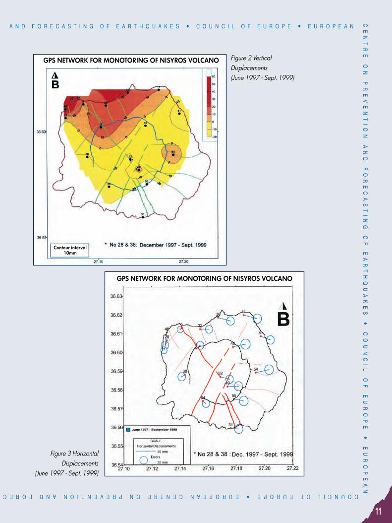
Surveillance of Nisyros Volcano: Geophysical and geodetic measurements 1999By: Prof. E. Lagios
National and Kapodistrian University of Athens, Faculty of Geology
GPS and Radon networks were established on Nisyros Island in June 1997, for the surveillance of its active volcano.Repeated measurements of the GPS network can provide a picture of the crustal deformation of the area due to theprobable upward magma motion or/and the breakout of an intense seismic activity. Parallel to the remeasurementsof the GPS network for the determination of vertical and horizontal crustal deformation of the area, the Radonnetwork was also re-measured. The radon level variations were therefore determined, and a correlation to theobserved seismic activity is aimed, especially by using the continuous time-series radon values provided by apermanently established multi-parameter radon-measuring station in Mandrakion (Nissyros), transmitting the datato Athens via satellite in real-time.It has been shown that no significant horizontal deformation has generally taken place in Nissyros for the last twoyears 1998 and 1999. The presently therefore observed deformation is the one remained in Nissyros since the endof 1997, after the earthquake crisis of 1996/97, being basically controlled by two major faulting zones of theisland. The previously (1997) registered uplift at all GPS stations of the network (20-40 mm) presenting a picture ofa “bulge”, seems to have been adjusted to previous normal levels, with the exception of the stations at the westernand northern part of the island, where their uplifted character (about 20 mm) still prevails.The radon level variation over Nisyros has not increased; on the contrary, some stations having systematicallylarger radon values compared to the others exhibit now half-level values than usual.The above observations seem to be compatible with the seismicity of the area, which seems to be at a lowadmittedly level.
1
Figure 1 Radon emission measurements (02/02-20/04/1999)
A N D F O R E C A S T I N G O F E A R T H Q U A K E S ñ C O U N C I L O F E U R O P E ñ E U R O P E A NC
EN
TR
E
ON
P
RE
VE
NT
IO
N
AN
D
FO
RE
CA
ST
IN
G
OF
E
AR
TH
QU
AK
ES
ñ
C
OU
NC
IL
O
F
EU
RO
PE
ñ
E
UR
OP
EA
N
11
COUNCIL OF EUROPE ñ EUROPEAN CENTRE ON PREVENTION AND FOREC
Figure 3 HorizontalDisplacements
(June 1997 - Sept. 1999)
Figure 2 VerticalDisplacements (June 1997 - Sept. 1999)
GPS NETWORK FOR MONOTORING OF NISYROS VOLCANO
GPS NETWORK FOR MONOTORING OF NISYROS VOLCANO
Contour interval10mm

OF E.C.P.F.E.ASTING OF EARTHQUAKESñ COUNCIL OF EUROPE ñ EUROPEAN CENTRE
ON
P
RE
VE
NT
IO
N
AN
D
FO
RE
CA
ST
IN
G
OF
E
AR
TH
QU
AK
ES
ñ
C
OU
NC
IL
O
F
EU
RO
PE
NE
WS
LE
TT
ER C O U N C I L O F E U R O P E ñ E U R O P E A N C E N T R E O N P R E V E N T I O N
12
Detection of submarine volcanoes in the Kos-Nisyros area By: P. Nomikou and D. Papanikolaou
National Centre for Marine Research
Nisyros is an active volcano at the eastern edge of the modern Aegean Volcanic Arc, composed exclusively ofQuaternary volcanic rocks. A systematic survey, especially in the submarine area between the islands of Nisyrosand Kos was undertaken, aiming at defining the relations between tectonism, seismicity and volcanism. The surveycomprised two cruises, one with the research vessel “ISKATEL” in October 1997, and the second in April 1998 withthe research vessel “AEGAEO”. A single channel seismic-reflection profiling system with air-gun as energy sourcewas used. A representative lithoseismic profile through a submarine volcanic outcrop is shown in Fig.1.The main results of this study are included in the two submarine maps given in Fig.2 and Fig.3 after reduction fromtheir original scale at 1/100.000: a) The bathymetric map and b) the map of the submarine volcanic outcrops. Thesubmarine area can be distinguished in several basins which are separated by the volcanic outcrops. The totalextension of the submarine volcanoes is 3-4 times more than the known outcrops on the islands. The overall neotectonic structure of the area is a tectonic graben of approximately E-W direction between thealpine basements of Kos island to the north and Tilos island to the south. In between, there is a mean sea-bottomlevel at about 600-700 m depth which is interrupted by several volcanic intrusions whose summits locally appearas small volcanic islands in the area around Nisyros and Yali. The lack of sediments overlying the volcanic domesindicates their very young age ranging between Upper Pleistocene and Holocene.
2
Fig. 1 Representative lithoseismic profile of a submarine volcanic outcrop, using air-gun on R/S “Aegaeo” in thearea west of Nisyros Island.

A N D F O R E C A S T I N G O F E A R T H Q U A K E S ñ C O U N C I L O F E U R O P E ñ E U R O P E A NC
EN
TR
E
ON
P
RE
VE
NT
IO
N
AN
D
FO
RE
CA
ST
IN
G
OF
E
AR
TH
QU
AK
ES
ñ
C
OU
NC
IL
O
F
EU
RO
PE
ñ
E
UR
OP
EA
N
13
COUNCIL OF EUROPE ñ EUROPEAN CENTRE ON PREVENTION AND FOREC
Figure 2

OF E.C.P.F.E.ASTING OF EARTHQUAKESñ COUNCIL OF EUROPE ñ EUROPEAN CENTRE
ON
P
RE
VE
NT
IO
N
AN
D
FO
RE
CA
ST
IN
G
OF
E
AR
TH
QU
AK
ES
ñ
C
OU
NC
IL
O
F
EU
RO
PE
NE
WS
LE
TT
ER C O U N C I L O F E U R O P E ñ E U R O P E A N C E N T R E O N P R E V E N T I O N
14
Figure 3

A N D F O R E C A S T I N G O F E A R T H Q U A K E S ñ C O U N C I L O F E U R O P E ñ E U R O P E A NC
EN
TR
E
ON
P
RE
VE
NT
IO
N
AN
D
FO
RE
CA
ST
IN
G
OF
E
AR
TH
QU
AK
ES
ñ
C
OU
NC
IL
O
F
EU
RO
PE
ñ
E
UR
OP
EA
N
15
COUNCIL OF EUROPE ñ EUROPEAN CENTRE ON PREVENTION AND FOREC
Seismic behaviour of historical and traditional structures. The case of construction in areas in the Aegean Sea
By: P. Touliatos, A. Milioti, E. TsakanikaNational Technical University of Athens, Faculty of Architecture
A. Historical and traditional aseismic construction technics in GreeceAll people living in Eastern Mediterranean have at a certain point and in some degree felt the phenomenon of anearthquake and have observed its consequences.From ancient times, Greek philosophers, such as Aristoteles, Pythagoras, Hepicouros have dealt with theearthquake phenomenon and tried to interpret it.It’s estimated that today, a 50% of the annual seismic energy of Europe and a 2% of the annual world seismicenergy, is released in Greece.In this country, people live developing civilizations and construct their monuments and buildings for manythousands of years. Surviving frequent and disastrous earthquakes they got familiar with the act of observation ofthe damages on their structures and so understood, more or less, their behaviour during seismic action. Rebuildingthem in better ways, trying to improve their resistance against the dynamic loading, the ancient constructorsexperimented with different materials, constructional systems, and sometimes, sophisticated detailing. Followinglong and hard paths of observation, experiments, failures and inventions they created local or more spread aroundaseismic technics, concerning basic members of a building (masonry, roof, e.t.c.), or even a complete buildingsystem.It is a fact that it is impossible to protect completely a construction against the, sometimes out of the humancapabilities limits, seismic force. In Greece, monuments, buildings, cities or even whole civilizations have been lostdue to seismic or/and volcano activities, since prehistoric times to our days (i.e. Thira volcano eruption 1600 B. C.,City of Argostoli complete destruction in 1953, Kalamata severe damages in 1986 e.t.c.).
On the other hand manyarchitectural monuments stand stillafter more then thousand years(i.e. Parthenon in Athens 438 B.C.,Hagia Sofia in Istanbul(Constantinople) 537 a.d., HosiosLoukas Monastery, 955 A.D. e.t.c.)in areas with, some times highseismic risk. Traditionallyconstructed buildings andsettlements all over Greece, existand are used for hundreds ofyears surviving, repeatedly,seismic action.In older times and despite the factthat the structural and dynamic
3
Fig. 1 “Akrotiri” settlement on Santorini island (Thira) 1650 B.C.(C. Palyvou 1988)

OF E.C.P.F.E.ASTING OF EARTHQUAKESñ COUNCIL OF EUROPE ñ EUROPEAN CENTRE
ON
P
RE
VE
NT
IO
N
AN
D
FO
RE
CA
ST
IN
G
OF
E
AR
TH
QU
AK
ES
ñ
C
OU
NC
IL
O
F
EU
RO
PE
NE
WS
LE
TT
ER C O U N C I L O F E U R O P E ñ E U R O P E A N C E N T R E O N P R E V E N T I O N
16
analysis methods were totally unknown, some veryefficient aseismic methods and technics weredeveloped by local, craftsmen. Nevertheless theseskilled workmen had a very deep knowledge of thematerials and the building systems of that time,which stayed the same and kept developing forcenturies, passing on from one generation to theother. They also had a very good conception ofevery small detail as well as of the whole of theconstruction. This deep knowledge accompanied bythe observation of the behaviour of structures duringearthquakes and the examination and repairs of thedamages led to the invention of very interesting andefficient aseismic construction systems.It is a well established principle, that today we muststrive to preserve the aseismic behaviour of thoseold buildings without changing their initialarchitectural, statical and dynamic conception in anyrestoration or conservation project, because thecorrectness of the chosen solutions has been provedseveral times during their existence all those years.Our goal should be the reestablishment of theirinitial (at least) strength and resistance toearthquakes in the most compatible and simple way.In this procedure the best possible knowledge of therelevant aseismic technic which has been used andthe aseismic design principles, is necessary.The modern educational, social and administrativesystems world-wide, don’t help very much neither theunderstanding of the traditional local aseismictechnic and design princinples, nor the developmentof special for each case repair and strengtheningmethods.Today the specialist who desings or realizes therepair or strengthening projects of an HistoricalBuilding frequently have been educated and/or areliving in different places, even countries, far awayfrom the subject of their study and its material,loading conditions and constructional originalities.The building regulations, on the other hand, usuallydon’t contribute very much during the procedure ofunderstanding an old structure and deciding theproper interventions. The modern buildingregulations usually have been issued by reinforced
Fig. 2 Wooden reinforcements of the masonry of the “Doheiarion” Monastery’s defensive tower
of Mount Athos (10th-11th century).(N.T.U.A. research work, P. Touliatos, K.Kouthias,
Perrakis Ph. and Voutsaras S.)

A N D F O R E C A S T I N G O F E A R T H Q U A K E S ñ C O U N C I L O F E U R O P E ñ E U R O P E A NC
EN
TR
E
ON
P
RE
VE
NT
IO
N
AN
D
FO
RE
CA
ST
IN
G
OF
E
AR
TH
QU
AK
ES
ñ
C
OU
NC
IL
O
F
EU
RO
PE
ñ
E
UR
OP
EA
N
17
COUNCIL OF EUROPE ñ EUROPEAN CENTRE ON PREVENTION AND FOREC
concrete specialists, and ignore anyspecific local environmental orconstructional originality. Mostly, they aretrying to protect an historical buildingmorphologically only. And of course thecontrol systems of the proper applicationeven of those non sufficient regulations areusually very weak.The only way, for the specialists, thedesigners, the constructors, the producersof special materials and the authorities ofa territory rich in traditional construction, tounderstand and get familiar with theproblems of local historical buildings, is todevelop an organised and analytical,local constructional data bank.Using the proper information of such adata bank the designers will be able tobecome aware of any originality andvulnerability of the traditional structureand to decide correct and compatibleintervention methods. The constructors will succeed in organizing theproper specialists for the use of local materials and buildings systems.The authorities will be able to create local regulations, so that therespect, the preservation, the development and the correct exploitationof the cultural, constructional heritage will be a fact.
B. Brief description of the research project in progressUnder this framework of thinking, a research project is in progressaiming at:ñ Proposing a methodology for the recording of historical structural
systems. Pilot application of the method for the documentation of localstructural systems of various historical periods and in both islands andcoastal areas in the Aegean Sea. Special emphasis will be given inthe attributes and features regarding seismic response and behaviourof the structure.
ñ Identifying and documentation of construction technics used in historical and traditional buildings from ancienttimes till today in respect to the seismic safety. Comparative study of these with construction technics used in otherareas in Greece.
Fig. 3 Typical example of masonry’s wooden reinforcementsduring last centuries in Greece from the island of Thassos.
Fig. 4 Wooden masonry’sreinforcements.
OF E.C.P.F.E.ASTING OF EARTHQUAKESñ COUNCIL OF EUROPE ñ EUROPEAN CENTRE
ON
P
RE
VE
NT
IO
N
AN
D
FO
RE
CA
ST
IN
G
OF
E
AR
TH
QU
AK
ES
ñ
C
OU
NC
IL
O
F
EU
RO
PE
NE
WS
LE
TT
ER C O U N C I L O F E U R O P E ñ E U R O P E A N C E N T R E O N P R E V E N T I O N
18
STRIM pilot project: Space technologies and G.I.S. for seismic risk monitoring on active tectonic structures. Synergy in application of space technics and G.I.S.
to aid seismic risk managers in decision making By: Prof. D. Papanikolaou, Dr. Ch. Metaxas, Dr. I. Parcharidis, Dr. S. Vassilopulou, Msc E. Basilakis
National Marine Center
a. BRIEF DESCRIPTION OF THE PROJECTActive tectonic structures and their elements, such as active seismic faults, are the main causes of seismic disastersin urban areas and is significant infrastructure (High Dams, Refineries etc). Seismic Hazard and Risk monitoring onthese active structures requires operation of dense seismological geodetic (i.e. GPS) and other networks, which arevery expensive and time-consuming in the context of emergency situations management. Remote sensingtechniques can offer an alternative in Seismic Hazard Monitoring as less money and time consuming and havingmultiple use. These technics are very effective in detecting, delineating and describing active faults and theircharacteristics because of recognizing in satellite images through certain morphostructures caused by faulting.Information on active tectonic structures and monitoring results integrated into G.I.S. could be well utilized byearthquake engineers while designing infrastructures, as well as by seismic risk managers of all interested partsand at all levels of administration while decision making. Moreover, the application of space techniques enablescomplete fault systems to be analyzed and monitored without travel and boundary issues, which hold theoperational possibilities of ground monitoring networks on States frontiers.The aim of this pilot project is to organize a practical exercise aiming at testing the cooperating capabilities of fiveEuropean Centers on tackling a specific problem that is applying Space Technologies and G.I.S. to monitoreseismic risk on Active Tectonic Structures with the purpose to demonstrate the possibility of inputting processedspace imagery to EDRIM Network in order to aid decision-making.The European Centers involved are:ñ European Center on Prevention and Forecasting of Earthquakes (Athens, Greece),ñ European Center of New Technologies for the Management of Natural and Technological Major Hazards
(Moscow, Russia),ñ European Center for Seismic and Geomorphological Hazards (Strasbourg, France),ñ European Center on Geodynamical Risks of High Dams (Tbilisi, Georgia),ñ Assosiated European Center of Training and Information of Local and Regional Autorities (Baku, Azerbaijan).The main objectives of the project are:1. To define and describe the parameters of active tectonic structures and associated seismic faults for two
seismically active areas with developed infrastructure and characterized by different geological history, for wellunderstanding the difference or similarity of related seismic hazard and risk parameters.
2. To assess the seismic hazard parameters which could be recognized and monitored on the basis of spaceimages processing and interpretation by using all the available remote sensing data, optical and radar, orcombined images from different sensors .
3. To integrate into G.I.S. the results of space imagery interpretation as specific informative layers with scope to aidseismic risk monitoring in given region.
4

A N D F O R E C A S T I N G O F E A R T H Q U A K E S ñ C O U N C I L O F E U R O P E ñ E U R O P E A NC
EN
TR
E
ON
P
RE
VE
NT
IO
N
AN
D
FO
RE
CA
ST
IN
G
OF
E
AR
TH
QU
AK
ES
ñ
C
OU
NC
IL
O
F
EU
RO
PE
ñ
E
UR
OP
EA
N
19
COUNCIL OF EUROPE ñ EUROPEAN CENTRE ON PREVENTION AND FOREC
4. To exchange knowledge and to transfer technologies and skill-sets in the field of space imagery processing andinterpretation and G.I.S. on the problem of Seismic Risk Monitoring on an international basis, among theCenters involved.
5. To prepare in a friendly for the non-specialist end-user form the processed space imagery which on thedetaction of active tectonic structures, seismic faults and seismic hazard parameters for input into the EDRIMnetwork in order to aid decision making of seismic risk managers.
WORK CONTENT Characteristics of main active faults, constituting active tectonic structures, have been recognized in satelliteimages through the related topographic and other features. To verify the results of image interpretation and to havethe additional information about active faults parameters, field observations on these faults was conducted.Informative layer on characteristics of active tectonic structures and associated seismic faults, as well as of seismichazard parameters derived from space images, have been prepared and integrated into G.I.S. for assessment ofpossibilities of seismic risk monitoring on these structures using space technics.For the purpose of the project, two test areas were selected: one in Greece and one in Azerbaijan. For the Greektest-site, the area of Heraklion prefecture, Central Crete was selected. In order to carry out the project the following space earth observation and other ancillary data were used: ñ SPOT XI, 4 bands (from visible to infrared), 20 m/pixelñ Digital Elevation Model (DEM), created from satellite SPOT PAN data, 20m/pixelñ Shaded relief map of the area, created from DEM, 20m/pixelñ Topographic maps scale 1:50,000ñ Sismological datañ Tectonic information capture from already existing tectonic and neotectonic mapsñ Results of field observations on neotectonic structures and their eventual affect on human infrastructures.The space data and the thematic maps were georeferenced in the same projection system EGSA’87 (HellenicGeodetic System). The combination and manipulation of the data were made in a G.I.S.
RESULTS AND CONCLUSIONSThe prospect results of this project could be summarized as following:ñ The satellite imagery may be used in a fully understandable way in a system made for decision making by non-
specialists on space technics matters.ñ The best synergy of Earth Observation data and other related thematic maps as well as databases that
describe the objects of the thematic maps was the main task we tried to achieve. In the project we used the bestoffered (spatial and spectral resolution) satellite multispectral data. An important progress should be achievedusing the new very high-resolution data (IKONOS) which will expand the applications and the quantity andquality of the capture information. Regarding the descriptive information as databases, they should beanalytical and often updated.
ñ Final products are displayed in a way that could be ‘’readable’’ also by non-specialists, using the GeographicInformation Systems, in this case ARC- VIEW s/w. Further effort should be on the technic of image processingand displaying the results, because the most simple image for the specialist is very difficult to be interpreted bythe non-specialist. The problem becomes more difficult when not optical but radar data are to be used. Moresteps must be done on this matter.

OF E.C.P.F.E.ASTING OF EARTHQUAKESñ COUNCIL OF EUROPE ñ EUROPEAN CENTRE
ON
P
RE
VE
NT
IO
N
AN
D
FO
RE
CA
ST
IN
G
OF
E
AR
TH
QU
AK
ES
ñ
C
OU
NC
IL
O
F
EU
RO
PE
NE
WS
LE
TT
ER C O U N C I L O F E U R O P E ñ E U R O P E A N C E N T R E O N P R E V E N T I O N
20
ñ New commercial satellites are getting into orbit in the near future and the new space images are going to havebetter characteristics for processing and interpretation and finally to become more palpable. It is more maturenowadays to use new remote sensing technics such as SAR Interferometry, as they are getting more and moreinto operational projects.
ñ It is significant to overcome an endogenous, but very important obstacle of the project regarding thepartnership between the involved European Centers that is the communication difficulties. Our experience onthis matter points out that communication between the Centers needs improvement.
The results of the project are presented in the multimedia CD available in E.C.P.F.E.

A N D F O R E C A S T I N G O F E A R T H Q U A K E S ñ C O U N C I L O F E U R O P E ñ E U R O P E A NC
EN
TR
E
ON
P
RE
VE
NT
IO
N
AN
D
FO
RE
CA
ST
IN
G
OF
E
AR
TH
QU
AK
ES
ñ
C
OU
NC
IL
O
F
EU
RO
PE
ñ
E
UR
OP
EA
N
21
COUNCIL OF EUROPE ñ EUROPEAN CENTRE ON PREVENTION AND FOREC
D2. NEOTECTONIC MAPS
Neotectonic Map of Greece, scale 1:100.000Sheet “Filiatra”
By: I. Mariolakos, I. Fountoulis, V. Sabot, A. Markopoulou-Diakantoni, R. Mirkou National and Kapodistrian University of Athens, Faculty of Geology
Campilation procedureThe compilation of the neotectonic map involved:ñ Collection of all available data on the geology, seismology, engineering geology, and hydrogeological
conditions of the area. The data included research papers and publicantions, geological maps, air-photos andsatellite images.
ñ Initial evaluation of the available data.ñ Study of air-photos (1:33,000 scale) and compilation of photogeological map.ñ Compilation of 1/50,000 tectonic map.ñ Compilation of 1/100,000 geomorphological - morphotectonic map.ñ Field work.
General Geological - Neotectonic characteristicsThe study area lies at the south-western part of Peloponnessos, which is located at the south-western extremity ofthe Hellenic arc, adjacent to the Ionian trough, between 21Æ30’-22Æ00’ E and 37Æ30’ N. It is bounded to the northby Mt. Lapithas, to the east by Mt. Lykeo and Ano and Kato Messinia basins, to the south by the morphologicaldepression of Pylos - Velika. The Ionian Sea forms the western boundary of the area.The neotectonics of Peloponnessos includes large-scale fault blocks (horsts and grabens) of mean E-W (in westernand northern Peloponnessos) and NNW-SSE trends (in central and eastern Peloponnessos). The study area islocated at the junction point between these two prevailing trends.
ConclusionsThe following can be said on the area covered by “Filiatra” 1/100,000 sheetåñ Both Alpine and post-Alpine formations crop out.ñ The post-Alpine formations occur in six main basins, bounded by large fault zones, each of which has its own
neotectonic evolution. These areå- Neda and Filiatra grabens are filled exclusively with marine deposits. Age: Lower - Middle Pleistocene for the
former and Lower Pleistocene the latter.- Kyparissia - Kalo Nero and Filiatra grabens, are filled with terrestrial, lacustrine and marine deposits, the age of
which spans from Miocene until the Holocene. In both grabens, marine deposits represent the Early Pleistocene.- Dorio and Ano Messinia grabens are filled with Plio-Pleistocene terrestrial deposits.
ñ Unconformities, lateral transitions and facie interchanges are frequent phenomena in the palaeographicevolution of the basins.
ñ The alpine rocks of Pindos Unit form the main mountain masses of the area.
1

OF E.C.P.F.E.ASTING OF EARTHQUAKESñ COUNCIL OF EUROPE ñ EUROPEAN CENTRE
ON
P
RE
VE
NT
IO
N
AN
D
FO
RE
CA
ST
IN
G
OF
E
AR
TH
QU
AK
ES
ñ
C
OU
NC
IL
O
F
EU
RO
PE
NE
WS
LE
TT
ER C O U N C I L O F E U R O P E ñ E U R O P E A N C E N T R E O N P R E V E N T I O N
22
ñ The faults and fault zones in the area can be grouped according to their offset in (i) faults and fault zones withoffset >100m. and (ii) secondary faults with an offset of a few tens of metres.According to their activity the faults can be classified inå
Seismic faultsActive faultsPossibly active faultsInactive faults
ñ The neotectonic setting of the area is characterised by the occurrence of large multifaulted blocks (horsts andgrabens) bounded by large fault zones, each of which displays particular seismotectonic features.
ñ Minthi, Tetrazio and Kyparissia horsts are the most relatively “stable” locations in the study area. They are crossedby numerous faults, however, do not appear to be active. Only their margins show signs of activity.
ñ Lepreo - N. Figalia fault zone, which forms the margin between Neda graben and Minthi horst, is active.ñ Neda fault zone, the margin between Neda graben and Tetrazio horst has an active segment, the one that lies
within the graben and a possibly active one, at the east.ñ Kyparissia - Aetos fault zone, the margin between Kyparissia - Kalo Nero graben and Kyparissia horst is possibly
active throughout its western part, from Kyparissia to Aetos, and inactive further to the east.ñ The kinematic analysis of the fault zones, faults and the large-scale open folding (“warping”) of the area, in
combination with a multitude of tectonic and geomorphologic features, shows the deformation type during theneotectonic period that is of brittle-ductile character. The stress field associated with this deformation is that of arotational couple.
ñ The vertical (uplift and subsidence) movements, deduced from the study of shoreline displacement duringQuaternary, coupled with geodetic data, confirm the above-mentioned view and prove that kinematically anddynamically the same condition is valid for the current deformation regime.
ñ The morphotectonic features (drainage networks, stream incision, planation surfaces, topographic discontinuities)are characteristic indicators for the determination of the long-term kinematic regime in tectonically active regions.
ñ The areas with pronounced tectonic features have dispalyed high seismicity since the historical times.ñ The prevailing engineering geological conditions, in combination with the expected mechanical behaviour of
each geological formation during earthquake events and quiescence periods, can indicate the possibility ofoccurrence of destructive subsidiary effects (landslides, rock falls, etc.) and determine the expected seismicityrating for each type or rock that outcrops in the area.

A N D F O R E C A S T I N G O F E A R T H Q U A K E S ñ C O U N C I L O F E U R O P E ñ E U R O P E A NC
EN
TR
E
ON
P
RE
VE
NT
IO
N
AN
D
FO
RE
CA
ST
IN
G
OF
E
AR
TH
QU
AK
ES
ñ
C
OU
NC
IL
O
F
EU
RO
PE
ñ
E
UR
OP
EA
N
23
COUNCIL OF EUROPE ñ EUROPEAN CENTRE ON PREVENTION AND FOREC

OF E.C.P.F.E.ASTING OF EARTHQUAKESñ COUNCIL OF EUROPE ñ EUROPEAN CENTRE
ON
P
RE
VE
NT
IO
N
AN
D
FO
RE
CA
ST
IN
G
OF
E
AR
TH
QU
AK
ES
ñ
C
OU
NC
IL
O
F
EU
RO
PE
NE
WS
LE
TT
ER C O U N C I L O F E U R O P E ñ E U R O P E A N C E N T R E O N P R E V E N T I O N
24
D3. TECHNICAL HANDBOOKS-TRAINING
Issuing of Technical Handbook: “Post-earthquake rapid usability assessment of buildings”
ObjectivesDuring the last decades several disasterous earthquakes have struck many regions around the world. The gainedexperience and the technological progress made on this field, are yet to be transformed into useful information, inthe form of practical, step-by-step, instructions to the experts who are involved in the post-earthquake response. The
Technical Handbooks are basic tools for the education process ofdisciplines and agencies involved in the earthquake relief phase and inemergency operations.The programme for Technical Handbooks issuing is:ñ “Search and Rescue Operations in Earthquakes” (1997 activity of ECPFE)ñ “Temporal Propping, Structural Supporting and Withdrawal of Risk
Elements” (1998 activity of ECPFE)ñ “Post-earthquake Rapid Usability Assessment of Buildings” (1999
activity of ECPFE)ñ “Post-earthquake Building Evacuation and Emergency Shelter Provision
for the Population” (2000 activity of ECPFE)The Technical Handbook “Post-earthquake rapid usability assessment of buildings”, now in process of issuing,reffers to the first degree inspection of buildings which is conducted immediately after an earthquake. The existingconditions and the often shortage of human resources, as well as the lack of the specific experience and the exactknowledge of on the spot engineers, make these operations especially difficult. Considering all the above, soundand step--by-step instructions should be given, in the form of a Technical Handbook, regarding the organisationaland technical aspects of the inspection process produced in 1999.The proceedings of an International Seminar on “Post earthquake emergency damage and usability assessment ofbuildings”, held in Athens in Sept. 22-24, 1993, will provide useful input for this Handbook. Moreover, the Greekexperience of about 250.000 inspections carried out after the Athens earthquake of Sept. 7th, 1999 and thelessons learnt, are still to be integrated into the final outcome.
Program contentsThe content of the Technical Handbook are:ñ Categories of buildings usability and an indicative description of damages for each category,ñ The Inspection Form and instructions on “how to fill it in”,ñ Guidelines on emergency safety measures after building inspection,ñ Posting on buildings,ñ Setting up the inspection teams (personnel, equipment, duties list),ñ Organisational aspects and procedures of the post-earthquake rapid buildings usability assessment,ñ Legal and administrative issues,ñ Appendix with photographs showing buildings correspondently to usability category.
1

A N D F O R E C A S T I N G O F E A R T H Q U A K E S ñ C O U N C I L O F E U R O P E ñ E U R O P E A NC
EN
TR
E
ON
P
RE
VE
NT
IO
N
AN
D
FO
RE
CA
ST
IN
G
OF
E
AR
TH
QU
AK
ES
ñ
C
OU
NC
IL
O
F
EU
RO
PE
ñ
E
UR
OP
EA
N
25
COUNCIL OF EUROPE ñ EUROPEAN CENTRE ON PREVENTION AND FOREC
Contribution of E.C.P.F.E. to a PACT 19 Workshop in Nisyros island
E.C.P.F.E. participated in the 6th scientific –training workshop on “Historical buildings in seismic areas” organizedby PACT 19 in Nisyros island on July 14-21, 1999. Nisyros is one of the islands of Dodecanese in the South-Eastern Aegean Sea. It is a part of the Aegean volcanicarc and it is considered as one of the most active areas in terms of volcanic reactivation. In 1996 seismic activitystarted causing damage of historical buildings in Mandraki. More than 40 people (students, academics, researchers and practitioners) from five European institutions from Italy,Spain, France, Belgium and Greece, took part in the workshop. They attended lectures on seismic response oftraditional and historical buildings and most important, worked on documentation and evaluation of the localstructural system taking into consideration seismic safety. Three multi-national working groups examined buildingsin the three villages of the island (Mandraki, Emporio and Nikia). It was a remarkable outcome of the work the identification of various structural systems on the small island. Thiscould be explained by the long seismic history of the island, as well as the existence of the volcano on Nisyros,
forcing changes into construction technics and structural system. The outcome of the field work and of the seminar was gathered in a volumecontaining drawings, photographs and texts with all the documentation on theidentification and analysis of local structural systems of Nisyros. It was exposedto the local authorities and the people of Nisyros in an open presentation onTuesday July 20th, 1999. A CD with the findings on Nisyros local structuralsystem will be produced shortly.
2
Nikia
Emporio
Group of participants in the volcano.

OF E.C.P.F.E.ASTING OF EARTHQUAKESñ COUNCIL OF EUROPE ñ EUROPEAN CENTRE
ON
P
RE
VE
NT
IO
N
AN
D
FO
RE
CA
ST
IN
G
OF
E
AR
TH
QU
AK
ES
ñ
C
OU
NC
IL
O
F
EU
RO
PE
NE
WS
LE
TT
ER C O U N C I L O F E U R O P E ñ E U R O P E A N C E N T R E O N P R E V E N T I O N
26
THE ATHENS EARTHQUAKE OF SEPTEMBER 7TH 1999
Some seismological aspects of the Athens earthquake of Sept. 7, 1999By: George N. Stavrakakis
Director of the Institute of Geodynamics, National Observatory of Athens
On September 7, 1999 at 11:56 GMT (14:56 local time) a moderate earthquake of moment magnitude MW =5.9 (MS = 5.9, ML = 5.4) occurred at a distance of about 18 km north of the city of Athens.The earthquake caused 143 fatalities, 700 injuries, and more than 70.000 people become homeless. Themostly damaged area was located in the northwestern suburbs of the city. Thirty buildings collapsed andthousands suffered major or minor damage.The mainshock was preceded by some foreshocks starting at 11:38 GMT with a small event of local magnitudeML = 3.2 followed by two other smaller shocks at 11:40 and 11:43 GMT both of ML = 2.5. It followed by intenseaftershock activity.The fault plane solution proposed by Harvard University (strike = 114Æ, dip = 45Æ, rake = -73Æ) sugests a WNW -ESE trending, almost south-dipping normal fault.The Institute of Geodynamics of the National Observatory of Athens installed a seismic network of eight analogseismographs to monitor the aftershock activity. In addition to that a digital network of 20 stations was alsoinstalled in collaboration with the Institute of Geophysics, University of Hamburg. In the following, somepreliminary results based on the analogue portable network are shown. More information aboutseismotectonics, focal process, source parameters and strong ground motion are given by Pavlides et al., 1999;Papadopoulos et al., 1999; Papanastassiou et al., 1999; Stavrakakis et al., 1999; Kalogeras and Stavrakakis,1999; Margaris et al., 1999.
ReferencesKalogeras, I. and G. Stavrakakis (1999). Strong motion observation from the destructive earthquake of Sept. 7th, 1999, inAthens, Greece. Proc. of 1st Conference on Advances on Natural Hazards Mitigation: Experience from Europe and Japan,Athens, 3-4 Nov. (extended abstract, 34-35pp).Margaris, B.N., Papaioannou, Ch.A., Papazachos, C.B., Theodoulidis, N.P., Karakostas, V.G., Karakaisis, G.F., and C. Skourtis(1999). Seismological and engineering seismological aspects of the Athens Sept. 7, 1999, earthquake (reference, some asabove, extended abstract, 42-43pp).Papadopoulos, G.A., Baskoutas, I., Chouliaras, G., Drakkatos, G., Kalogeras, I., Karastathis, V., Kourouzidis, M., Latoussakis, I.,Makaris, D., Melis, N., Panopoulou, G., Papanastassiou, D., Pappis, I., Tassos, S., Plessa, A., and G. Stavrakakis (1999).Seismological aspects of the Athens earthquake of 7th September 1999: Preliiminary results (reference some as above, 73-79pp).Papanastassiou, D., Stavrakakis, G., Drakatos, G., and G.A. Papadopoulos, (1999). The Athens, September 7, 1999, Ms=5.9mearthquake: First results on the focal properties of the main shock and the aftershock sequence (sub. for publication).Pavlides, S.B., Papadopoulos, G.A., Ganas, A., (1999). The 7th September 1999 unexpected earthquake of Athens:Preliminary results on the seismotectonic environment (see first reference, 80-85pp).Stavrakakis, G., Chouliaras, G. and G. Panopoulou (1999). Seismic source parameters for the Athens earthquake of Sept. 7,1999, from a new telemetric broad band seismological network in Greece (sub. for publication, Pageoph).
1

A N D F O R E C A S T I N G O F E A R T H Q U A K E S ñ C O U N C I L O F E U R O P E ñ E U R O P E A NC
EN
TR
E
ON
P
RE
VE
NT
IO
N
AN
D
FO
RE
CA
ST
IN
G
OF
E
AR
TH
QU
AK
ES
ñ
C
OU
NC
IL
O
F
EU
RO
PE
ñ
E
UR
OP
EA
N
27
COUNCIL OF EUROPE ñ EUROPEAN CENTRE ON PREVENTION AND FOREC
Figure 1. Aftershocks distribution of the well locate aftershocks forthe time period Sep. 08 - Oct. 03, 1999,indicating a trending WNW - ESE in consistency withthe proposed fault planesolution.
Figures 2 and 3. The cross sections (E-W and N-S) that verifythe south-dipping of the fault plane. The cross symbol depicts
the focal depth of the mainshock.

OF E.C.P.F.E.ASTING OF EARTHQUAKESñ COUNCIL OF EUROPE ñ EUROPEAN CENTRE
ON
P
RE
VE
NT
IO
N
AN
D
FO
RE
CA
ST
IN
G
OF
E
AR
TH
QU
AK
ES
ñ
C
OU
NC
IL
O
F
EU
RO
PE
NE
WS
LE
TT
ER C O U N C I L O F E U R O P E ñ E U R O P E A N C E N T R E O N P R E V E N T I O N
28
Figure 5. The b-valuedistribution with the
aftershocks. The value b= 1 is obtained for the
focal region, which is acommon value for
aftershock sequences inthe area of Greece.
Figure 4. The 3-D distribution of theaftershocks. It is evident that the majorityof the aftershocks occurred at a depthrange between 5 and 15 km. Some ofthem took place deeper up to 25 km.
A N D F O R E C A S T I N G O F E A R T H Q U A K E S ñ C O U N C I L O F E U R O P E ñ E U R O P E A NC
EN
TR
E
ON
P
RE
VE
NT
IO
N
AN
D
FO
RE
CA
ST
IN
G
OF
E
AR
TH
QU
AK
ES
ñ
C
OU
NC
IL
O
F
EU
RO
PE
ñ
E
UR
OP
EA
N
29
COUNCIL OF EUROPE ñ EUROPEAN CENTRE ON PREVENTION AND FOREC
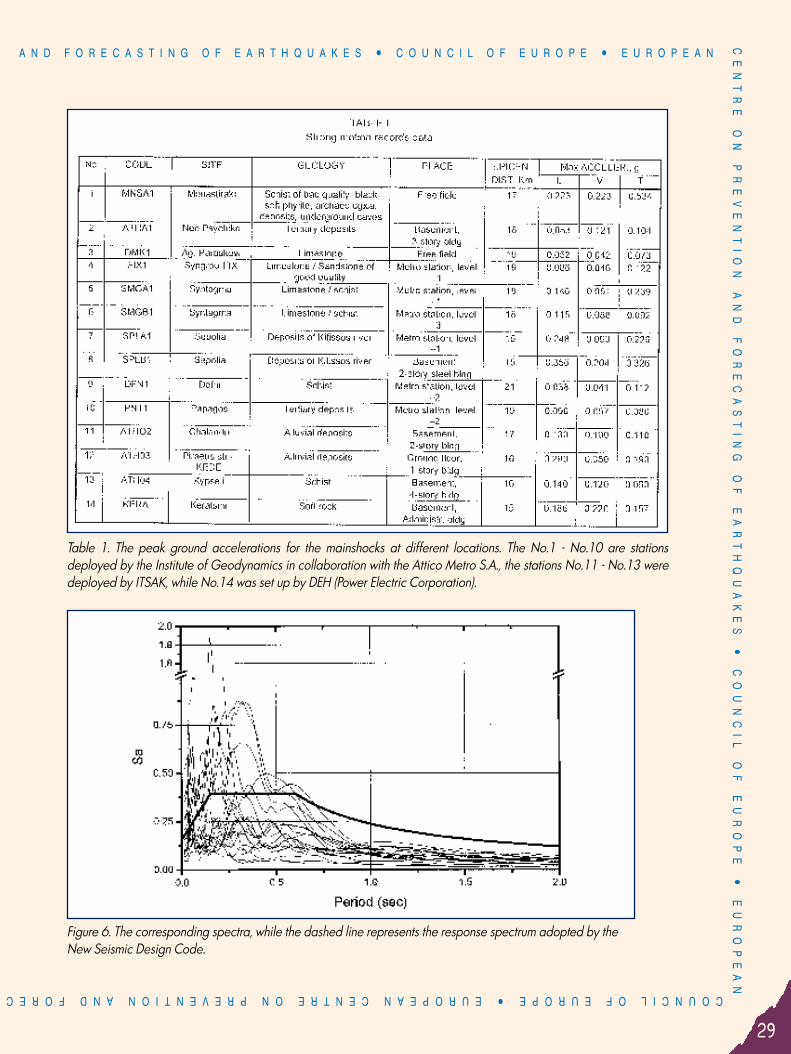
Table 1. The peak ground accelerations for the mainshocks at different locations. The No.1 - No.10 are stationsdeployed by the Institute of Geodynamics in collaboration with the Attico Metro S.A., the stations No.11 - No.13 weredeployed by ITSAK, while No.14 was set up by DEH (Power Electric Corporation).
Figure 6. The corresponding spectra, while the dashed line represents the response spectrum adopted by theNew Seismic Design Code.

OF E.C.P.F.E.ASTING OF EARTHQUAKESñ COUNCIL OF EUROPE ñ EUROPEAN CENTRE
ON
P
RE
VE
NT
IO
N
AN
D
FO
RE
CA
ST
IN
G
OF
E
AR
TH
QU
AK
ES
ñ
C
OU
NC
IL
O
F
EU
RO
PE
NE
WS
LE
TT
ER C O U N C I L O F E U R O P E ñ E U R O P E A N C E N T R E O N P R E V E N T I O N
30
Geology and tectonics of Western Attica in relation to the 7-9-99 earthquakeBy: Professor D.I. Papanikolaou
in collaboration with: Dr. E. Lekkas, Dr. Ch. Sideris, Dr. I. Fountoulis, Dr. G. Danamos, Dr. Ch. Kranis, Dr. L. Lozios and at the contribution of: I. Antoniou, E. Vassilakis, S. Vasilopoulou,
P.Nomikou, I. Papanikolaou, E. Skourtsos and K. Soukis Department of Dynamic, Tectonic and Applied Geology, University of Athens
1. Introduction Immediately after the 5,9 magnitude earthquake of Sept.7 1999 which stroke the NW area of the Athenian basin, acoordinated investigation on the geology and tectonics of the area was set up. The research was focused to apreliminary assessment of the geologic-tectonic-geomorphologic conditions of the area in correlation with thespecific characteristics of this earthquake and its effect on the structures. This study was accomplished incollaboration with Professor P.Marinos and co-workers of the Technical University of Athens, according to theinstructions of the Minister of Environment, Planning and Public Works.Past of this work was based on studies and research previously undertaken by members of the scientific team, mainlyduring the elaboration of the Neotectonic Map of Eastern Attica since 1993.Since the very beginning of the earthquake event, the scientific team checked several areas of the northwestern partof the Athenian basin from the Aegaleo Mt. up to the southern slopes of Parnitha Mt., through systematic fieldsurveying. The field work was complemented by laboratory data including areal photographs and satellite imagesat various scales. The presentation of the preliminary conclusions of this research was made on maps at scale1/25.000, which are given at reduced scale in this report.
2.Geology and Tectonics of AtticaThe geological structure of Attica comprises two groups of alpine basement rocks and post-alpine sediments (Fig.1):a) The upper group is made mainly of Mesozoic carbonate rocks (limestones and dolomites of Triassic and Jurassic
age) overlying a clastic formation of shales and sandstones including olistholites of Permian limestones. Someophiolitic rocks are locally preserved over the carbonate platform which were tectonically emplaced during thepalaeoalpine orogeny of Late Jurassic-Early Cretaceous. Upper Cretaceous shallow water carbonates and earlyTertiary flysch cover the previous formations, which belong to the geotectonic unit of Eastern Greece (composedof the Sub-Pelagonian palaeotectonised Unit, the ophiolite nappe of the Axios-Vardar oceanic basin and theUpper Cretaceous transgressive platform). This upper unit extends only to the northwestern part of Attica, formingthe major mountain range of Parnitha and other minor mountains like Aegaleo in the western side of the Athenianbasin.
b) The lower group is made mainly of metamorphic rocks, including marbles, micaschists e.t.c cropping out in thearea of Penteli mountain to the east and Imittos mountain to the south of the Athenian basin.
The tectonic contact between the two groups of the alpine basement strikes in the NE-SW direction and dips towardsthe NW. Although this tectonic contact is usually covered by post-alpine sediments its position is markedapproximately by Kifisos River which is outfloating in the area of Pireaus. The post alpine sediments comprise mainly neogene lacustrive lignite bearing deposits and continental quaternaryformations.
2

A N D F O R E C A S T I N G O F E A R T H Q U A K E S ñ C O U N C I L O F E U R O P E ñ E U R O P E A NC
EN
TR
E
ON
P
RE
VE
NT
IO
N
AN
D
FO
RE
CA
ST
IN
G
OF
E
AR
TH
QU
AK
ES
ñ
C
OU
NC
IL
O
F
EU
RO
PE
ñ
E
UR
OP
EA
N
31
COUNCIL OF EUROPE ñ EUROPEAN CENTRE ON PREVENTION AND FOREC
Figure
1

OF E.C.P.F.E.ASTING OF EARTHQUAKESñ COUNCIL OF EUROPE ñ EUROPEAN CENTRE
ON
P
RE
VE
NT
IO
N
AN
D
FO
RE
CA
ST
IN
G
OF
E
AR
TH
QU
AK
ES
ñ
C
OU
NC
IL
O
F
EU
RO
PE
NE
WS
LE
TT
ER C O U N C I L O F E U R O P E ñ E U R O P E A N C E N T R E O N P R E V E N T I O N
32
The neotectonic structure of Attica comprises a numberof major faults striking in the E-W and NW-SE direction.The simplified map of Fig.1 includes only the most activeneotectonic faults whose length is exceeding 7-8 Kmwith a seismic potential of magnitude >5. The ENE-WSWto E-W neotectonic trend in western Attica betweenKorinthiakos and Saronikos gulfs is related to largeearthquakes of magnitude 6,5 to 7, like those of 1981.On the contrary, the NW-SE neotectonic trend in easternAttica, extending also along the western coast of theSouthern Evoikos gulf is related to smaller earthquakes ofM ∼− 6.0 about 6, like the Oropos earthquake in 1938.The tectonic profiles of Fig.2 show the above alpine andneotectonic structure on both sides of the Athenian basin.
3.The Earthquake of September 7, 1999.The systematic survey of the area after the earthquake of September 7, 1999 and especially along the neotectonicfaults together with the available seismological data from the Geodynamic Institute of the National Observatorylead to several conclusions which can be summarized as following:1. The seismic rupture of the main shock had a WNW-ESE direction with a dip of about 40 degrees towards SSW.
The movement of the fault was normal, with subsidence of the SW block, which is located beneath the SaronikosBay area. The above general fault geometry of the main shock was confirmed also by the distribution of theepicentres of the aftershocks, which delineate a rectangular frame shown on Fig.1 and Fig.4, below westernParnitha Mt.
2. The seismic fault was generated at a depth of about 15-20 Km, without surface rupture. The only minor seismicrupture was observed in the SW area of Parnitha Mt. to the NW of Phyli within the alpine basement, along severalhundreds metres with occurrence of linear significant rock falls in the adjacent areas. It is remarkable that thisseismic rupture has a WNW-ESE orientation, similar to that of the seismic fault at depth but an opposite diptowards NNE. All the rest ruptures that have been observed in the wide region did not correspond to seismicruptures but to local fissures due to unstable soil slopes or cracks opened along previous rock discontinuities.
3. The large neotectonic faults of the wide area were not activated even though precisely in the area of theepicentral zone a neotectonic fault of the same geometry as the seismic fault occurs. This fault runs parallel to theeastern boundary of Thriasio basin and is almost parallel to the seismic fault at depth with approximately 15 Kmdifference in elevation (Fig.3 and 4).
4.The damage distribution in relation to the geology and tectonics The damage distribution shows a general NE-SW trend , which is almost perpendicular to the direction of the WNW-ESE seismic zone of the 7.9.99 earthquake (Fig. 1,4 and also map of Marinos and co-workers). This particular trendfollows the tectonic boundary between the metamorphic and non metamorphic rocks of the alpine basement ofAttica, which runs along and beneath Kifisos River. This tectonic boundary together with the sub-parallel marginalfaults of the Athenian basin running along the eastern slopes of Aegaleo and Parnitha Mts. have shaped the zones ofmajor damage.The neogene marginal faults of the Athenian basin controlled the linear distribution of damage even in areas wherethey are covered by Quaternary slope breccias as in the area of Thrakomakedones, where young well constructedstructures were severely affected by the earthquakes.
Figure 2

A N D F O R E C A S T I N G O F E A R T H Q U A K E S ñ C O U N C I L O F E U R O P E ñ E U R O P E A NC
EN
TR
E
ON
P
RE
VE
NT
IO
N
AN
D
FO
RE
CA
ST
IN
G
OF
E
AR
TH
QU
AK
ES
ñ
C
OU
NC
IL
O
F
EU
RO
PE
ñ
E
UR
OP
EA
N
33
COUNCIL OF EUROPE ñ EUROPEAN CENTRE ON PREVENTION AND FOREC
In general, the damage zones were mainly shapedpassively by the NE-SW tectonic structures cutting throughthe Athenian basin from the area of Pireas up to the passbetween Penteli and Parnitha Mts. and only secondarily bythe energetic action of the WNW-ESE seismic fault that wasactivated at depth. It is remarkable that the seismic zoneappears to end towards the ESE along the Kifisos River(Fig.1,4). Thus, it seems that the seismic energy was reflectedfrom the seismic zone along the NE-SW major alpinetectonic contact up to the surface in the area of Liossia,Menidi and Thrakomakedones.The role of the geological basement as foundation soil isimportant but not determinative, since in soils of similarquality we observe extreme differentiations of the degree ofdamage over constructions of similar quality. Nevertheless, itseems that only slight damage is observed in constructionsbuilt on alpine basement rocks. Significant differentiation ofdamage is observed also in areas with important changes inmorphological slope.The general conclusion is thatthe damage distribution is acombination of several factors,besides the foundation soil,including the older tectonicstructures and the geomor-phological discontinuities.
ReferencesLepsius, R.1893. Geologie von Attica. Berlin.Papanikolaou D. 1986. Geology of Greece (in Greek). 240p.Papanikolaou, D., Mariolakos, I., Lekkas, E. & Lozios, S. 1988. Morphotectonic observations of the Asopos Basin and the coastalzone of Oropos. Contribution to the neotectonics of Northern Attica. Bull. Geol. Soc. Greece, XX/1, 251-267.Papanikolaou, D. & Lozios, S. 1990. Comparative neotectonic structure of high (Korinthia-Beotia) and low rate (Attica-Cyclades)activity. Bull. Geol. Soc. Greece, XXVI, 47-65.
Figure 3
Figure 4

OF E.C.P.F.E.ASTING OF EARTHQUAKESñ COUNCIL OF EUROPE ñ EUROPEAN CENTRE
ON
P
RE
VE
NT
IO
N
AN
D
FO
RE
CA
ST
IN
G
OF
E
AR
TH
QU
AK
ES
ñ
C
OU
NC
IL
O
F
EU
RO
PE
NE
WS
LE
TT
ER C O U N C I L O F E U R O P E ñ E U R O P E A N C E N T R E O N P R E V E N T I O N
34
Figure 5

A N D F O R E C A S T I N G O F E A R T H Q U A K E S ñ C O U N C I L O F E U R O P E ñ E U R O P E A NC
EN
TR
E
ON
P
RE
VE
NT
IO
N
AN
D
FO
RE
CA
ST
IN
G
OF
E
AR
TH
QU
AK
ES
ñ
C
OU
NC
IL
O
F
EU
RO
PE
ñ
E
UR
OP
EA
N
35
COUNCIL OF EUROPE ñ EUROPEAN CENTRE ON PREVENTION AND FOREC
Active tectonic structures of Attica and geodynamicsituation related to Athens earthquake
By: Dr. D. Foundoulis, Dr. Ch. Metaxas, Dr. S. Lalechos, Dr. A. KourouEarthquake Planning & Protection Organisation (E.P.P.O.)
On September 7 1999 at 14:56 local time, a moderate (MS =5.9) but devastating earthquake struck the districts ofAthens in Western Attica and was followed by an aftershock sequence with magnitude range of MS≤4.7.Most of research seismological institutions locate the main shock within the Thriasio neotectonic basin on SW slope ofParnitha mountain ridge with coordinate Lat.: 38.08ÆN, Lon.: 23.61ÆE and at depth interval 9-20 km. The focalmechanism solution, determined by USGS and HARVARD, suggested a NW-SE trending normal fault (114Æ-123Æ)with left-lateral horizontal component, dipping to SW about 45Æ-55Æ, with subhorizontal extensional axis orientedNNE (about 208Æ). The greatest observed intensity was IX of MM-Scale according to G. Protonotarios, N.T.U.A.. A scientific team from E.P.P.O. carried out the field microtectonic observations in the mesoseismal area starting thenext day of Athens earthquake. Earthquake induced phenomena (ground fissures, rock falls) were recorded at 46points in total all over the affected area. Some of the observed characteristics of the earthquake, which could be considered as unusual, are: ñ relative high macroseismic intensity with respect to event magnitude and depth, ñ absence of sufficient surface expression of seismogenic fault along with intense rock falls and serious road
damages in the Parnitha mountain, ñ discordance between the geometry and kinematics of ground fissures and seismogenic fault. The geological, remote-sensing (Landsat-5 TM images) and gravity data, as well as the results of field microtectonicobservations were analysed in order to understand the active tectonic structure of Attica and the correspondinggeodynamic situation during the main shock. Considering the distribution of main shock stress tensor and principal stress tensor of concomitant geodynamicphenomena together (Fig.1) as well as some peculiarities of surface faulting, derived from Landsat-5 TM satelliteimage, and deep faulting, determined on the Gravity Anomaly Map of Greece published by Lagios et al., 1994, inBouguer reduction (Fig.2), the following conclusion can be drawn.
There is a number of blocks of relatively small (up to 10-15 km) cross-sizes in Attica, which have beenaccommodated by successive alpine and post-alpine deformations (compressive and tensional) of the area. Horizontal axes Û2 and Û3 of observed stress tensor of Athens earthquake concomitant ground fissures are bothtensional and more of less equal in absolute value, whilst the axis Û2 coincides with the axis T of the main shocksource mechanism but not the axis Û3 as could be expected. During the main shock of Athens earthquake sequence several microblocks have moved each in its own way,along the activated by earthquake pro-existed bordering faults, in accordance with one of tensional axes, Û2 orÛ3. This geodinamic situation, in association with blocks geometry, testifies the existence of spread tension andsuggests the prevailing of vertical movements in the under study area during the main shock of Athensearthquake sequence.Some of fault zones, due to their lengths, can cause serious events. Therefore, these faults, most of them withunknown behavior, have to be studied further in order to assess seismic hazard and corresponding riskparameters for Athens Metropolitan Area and the adjacent areas.
3

OF E.C.P.F.E.ASTING OF EARTHQUAKESñ COUNCIL OF EUROPE ñ EUROPEAN CENTRE
ON
P
RE
VE
NT
IO
N
AN
D
FO
RE
CA
ST
IN
G
OF
E
AR
TH
QU
AK
ES
ñ
C
OU
NC
IL
O
F
EU
RO
PE
NE
WS
LE
TT
ER C O U N C I L O F E U R O P E ñ E U R O P E A N C E N T R E O N P R E V E N T I O N
36
Fig. 1 Kinematic analysis of seismic ground fissuresA) Spatial distribution of planes with measured(s) and predicted (Ù) slip vectors (Wulff stereonet, lower hemisphere),B) Histogram of deviations between measuredand predicted slip vectors for each plane
Quaternanry deposits
Neogene formations
Alpine units: 3-Pelagonian zone
Attico-cycladic zone
Magmatic rocks
Upthrust
Main surface faults derived from IANDSAT-5 TM satellite image; Deep faultsdetermined in gravity field;
Major deep faults of couple, bordering the Parnitha tectonic structureand constituting the framework of Athens earthquake sequence,Other major deep faults,
Minor faults
Fault mechanism of the main shock
Tensional direction associated with fault mechanism of the main shock
Spatial distribution of seismic rupture planes
Tensional directions associated with seismic surface ruptures.
Fig. 2 Model of active tectonic structure of Attica and geodynamic model related to Athens earthquake. Post-alpine units:

A N D F O R E C A S T I N G O F E A R T H Q U A K E S ñ C O U N C I L O F E U R O P E ñ E U R O P E A NC
EN
TR
E
ON
P
RE
VE
NT
IO
N
AN
D
FO
RE
CA
ST
IN
G
OF
E
AR
TH
QU
AK
ES
ñ
C
OU
NC
IL
O
F
EU
RO
PE
ñ
E
UR
OP
EA
N
37
COUNCIL OF EUROPE ñ EUROPEAN CENTRE ON PREVENTION AND FOREC
Damage distribution in the western part of Athens after the 7-9-99 earthquakeThe text and maps are taken from Part B. “Soil classification due to earthquakes, of Western Athens area”
of the study “Preliminary geological - geotechnical study of the disaster area (of Athens earthquake
of Sept 7th, 1999) in NW Athens Basin” conducted for the Ministry of Environment, Planning and Public Works.
Part B. of the study was carried out by P.Marinos, G. Boukovalas, G. Tsiambaos, G. Protonotarios, N. Sabatakakis and
collaborators (N.T.U.A., Faculty of Civil Engineering, Dpt. of Geotechnical Engineering)
Figure 1 presents the map of damage distribution in the area of the western Attica Basin between Kifisos river andthe mountains Parnitha and Aegaleo. Table I gives a brief description of the four categories of damage used for thepreparation of the map.The mapping of damages is not finished yet, and in many cases was basedonly on the external inspection of the building and on the results of the firstdegree, rapid, post-earthquake inspection. Thus it gives a rough picture ofdamage in western Attica Basin. This image allows us to get to someconclusions on the seismic wave propagation, the possible site effect or ofother mechanisms due to local characteristics that must be considered in thereconstruction and the future construction. A more accurate picture will beobtained when the mapping of damage will be completed and the results fromthe second degree damage assessment of buildings will be taken into account.In the following the principal conclusions that came out of the damagedistribution map are presented. It should be noticed that the soil conditions inthe examined areas, as well as the epicentre position of the main earthquakeas it was published by the National Geodynamic Institude of Athens(38.10ÆN, 23.56ÆE, depth 19km), were taken into account.a) The severe and heavy damage (orange and red color on the map) were
concertrated in the areas of Ano Liosia, Axarnes and Thrakomakedones,at a distance of 6 to 12 km from the epicentre.The accelerations in these areas are not known, since there werenot any recordings of accelerations there. Nevertheless, it is obvious that these should have been high because ofthe small distance from the epicentre.
b) Severe and in some cases heavy damage (orange and red color on the map) was observed in scaterred areasfar away from the epicentre, such as Adames, N. Liosia, Western Metamorfosi, Anthoupoli, Dasos Xaidariou,Lioumi and Prosfygika of Aigaleo. In these areas damages cannot be associated only with the close distancefrom the epicentre. On the contrary, damage in these areas indicates that there are also other factors that causedlocal amplification of the earthquake groundmotion. These factors could have been the soil conditions, thetopography, the direction of the rupture and the particularities of a significant underground geological structureof the bedrock in the broader area. (More details about the last factor are given in the Report of Prof.D.Papanikolaou and his team, of the Geological Department of the University of Athens).
c) The indications for local amplification of the earthquake groundmotion in recent deposits, reculting from thecomparative examination of the geological and damage distribution maps are many, in the epicentric zone aswell as out of it. Some of these are mentioned as follows:- In the Acharnes area there is a clear seperation between the north area where the damage was heavy and the
south area where there was moderate damage.The limit between these two areas is more or less in accordancewith the limit between the recent, more loose, soil deposits in the north area and the rock structure in the south.
4
TABLE I CATEGORIES OF DAMAGE*
* This classification was made with the purpose of intensitydistribution and not of the building usability assessment.
Color DescriptionLight blue Slight damageYellow Moderate damage (e.g. fine
cracks to the walls)Orange Severe damage (e.g. large
cracks or diagonal crackson the masonry walls, finecracks in structural members)
Red Heavy damage (e.g. largecracks in structural members,collapse)

OF E.C.P.F.E.ASTING OF EARTHQUAKESñ COUNCIL OF EUROPE ñ EUROPEAN CENTRE
ON
P
RE
VE
NT
IO
N
AN
D
FO
RE
CA
ST
IN
G
OF
E
AR
TH
QU
AK
ES
ñ
C
OU
NC
IL
O
F
EU
RO
PE
NE
WS
LE
TT
ER C O U N C I L O F E U R O P E ñ E U R O P E A N C E N T R E O N P R E V E N T I O N
38
- In Ano Liosia heavy damage and the collapses are found in the broader area of Zone 2 of Limni and of thecentral Ano Liosia, where the alluvium deposits prevail.
- In Nea Liosia the severe and heavy damage is concetrated in areas where the soils are cohesive and thick andthey are bounded perimetrically by indications of rock structure on the surface of Zone 1.
d) In several cases there are strong indications of the influence of topography on local amplification ofgroundmotion and therefore on the damage. It is characteristic that heavy damage occurred in buildings,especially industrial buildings, on Tatoiou Avenue, which were built on the top of West slope of Xelidonous stream(between the Stream and Tatoiou Avenue). The same factor could have affected the occurrence of severedamage in the areas Adames, between the National Road and Helidonous stream.
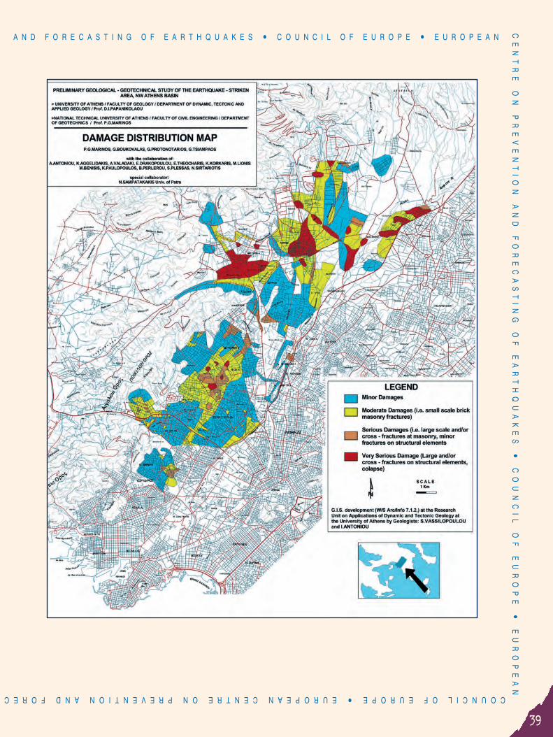
A N D F O R E C A S T I N G O F E A R T H Q U A K E S ñ C O U N C I L O F E U R O P E ñ E U R O P E A NC
EN
TR
E
ON
P
RE
VE
NT
IO
N
AN
D
FO
RE
CA
ST
IN
G
OF
E
AR
TH
QU
AK
ES
ñ
C
OU
NC
IL
O
F
EU
RO
PE
ñ
E
UR
OP
EA
N
39
COUNCIL OF EUROPE ñ EUROPEAN CENTRE ON PREVENTION AND FOREC

OF E.C.P.F.E.ASTING OF EARTHQUAKESñ COUNCIL OF EUROPE ñ EUROPEAN CENTRE
ON
P
RE
VE
NT
IO
N
AN
D
FO
RE
CA
ST
IN
G
OF
E
AR
TH
QU
AK
ES
ñ
C
OU
NC
IL
O
F
EU
RO
PE
NE
WS
LE
TT
ER C O U N C I L O F E U R O P E ñ E U R O P E A N C E N T R E O N P R E V E N T I O N
40
Disaster response and reconstruction measures after the Athens Earthquake of September 7, 1999 (M=5.9)
By: V. Andrianakis, President of E.P.P.O.
M. Dandoulaki, Alternate Director of E.C.P.F.E.
N. Papadopoulos, Director of E.P.P.O.
The main characteristics and primary effects of the earthquake At 14:57 on September 7th, 1999 there was a severe earthquake of Ms=5,9, 18 km NW of Athens. The earthquakeaffected a large area, part of which is Athens Metropolitan Area, causing intensities up to X-MM Scale in someareas. Tens of buildings collapsed, among them six factories. Since the earthquake took place during working hours,
hundreds of people were trapped in the ruins. A number of 143 people died either indamaged buildings or by falling objects or of heart attacks. About 7,000 people wereinjured and more than 70.000 households became homeless. The power went off inmany areas, this contributing to huge traffic jams. The telephone communicationsystem was blocked by overuse (telephone panic) for several hours. The population inall Attica was alarmed and emergency evacuation of buildings took place.
Emergency response Immediately after the event all human and material resources of the key responseservices were mobilized. The National Emergency Operations Centre at GeneralSecretariat for Civil Protection was activated, as well as the Operational Centres ofcritical Services, i.e. Fire Services, Earthquake Planning and Protection Organisation,National Centre for Emergency Health Care (EKAB).Of great significance was to obtain information on the situation as soon as possible.Given that all phones including the cellular ones, were blocked, initial information
came from police and fire departments through theirradiocommunication network. Disaster assessment teams were sentall over Attica. Helicopters were used for aerial survey. The mediaalso communicated a rough picture of the situation.Communications between disaster assessment teams and theOperation Centres were established soon after, through handradios. Volunteers were used to facilitate radiocommunications. Search and rescue was the first priority. Rescue operations took
place in 32 collapsed buildings. The Greek rescue team, FireBrigade, volunteers, engineers from EPPO and medical personel
from the National Centre for Emergency Hearth Care, took part in search and rescue operations. Rescue teams fromCyprus, France, Germany, Hungary, Israel, Russian Federation, Switzerland and Turkey, arrived the next day in orderto assist in search and rescue.Informing the population was also vital and urgent. The media were very helpful at informing people, on the otherhand they put pressure on decision makers and disaster managers requesting constantly information. In less than anhour after the earthquake official instructions were disseminated through the media on what people should do andnot do during the emergency situation.
5

A N D F O R E C A S T I N G O F E A R T H Q U A K E S ñ C O U N C I L O F E U R O P E ñ E U R O P E A NC
EN
TR
E
ON
P
RE
VE
NT
IO
N
AN
D
FO
RE
CA
ST
IN
G
OF
E
AR
TH
QU
AK
ES
ñ
C
OU
NC
IL
O
F
EU
RO
PE
ñ
E
UR
OP
EA
N
41
COUNCIL OF EUROPE ñ EUROPEAN CENTRE ON PREVENTION AND FOREC
At the same time, a series of emergency operations took place.Some of these were: ñ Safety inspection of buildings housing critical facilities
(hospitals, police stations, fire departments, emergencyoperation centres, specific public functions e.t.c.). Temporaryaccomodation of critical facilities, if nessecary.
ñ Traffic control. ñ Damage inspection and re-operation of life-lines. ñ First aid and medical care ñ Safety inspection of public buildings ñ Distribution of drinkable water, food and other items of
immediate need. ñ Installation of portable toilettes ñ Shelter provision
Rapid safety evaluation and damage assessment ofbuildingsThe next day the first degree, rapid safety assessment of buildingsstarted, aiming at warning the occupants about the unsafebuildings. The standard method for rapid inspection of buildingsissued by Earthquake Planning and Protection Organization in1998, was used. Buildings were categorized in three categoriesand posted accordingly as:
Red: Unusable - Dangerous. No entry.Yellow: Temporarily unusable. Limited entry at own risk.Green: Possibly damaged but usable.
The operation was coordinated by the Ministry of Environment,Regional Planning and Public Works and it was carried out bygroups of engineers either public servants or volunteers. More than250.000 inspections were carried out in the wider area of Athens,were inspected. Approximately 50% of the buildings were deemednot safe to be occupied.A few weeks later the second degree damage assessment ofbuildings was carried out at approximately 220.000 apartmentsand business premises in about 65.000 buildings. Damage wasfound in approximately 94.000 of them, 7% of which have beencharacterized as “Dangerous – Beyond repair”.Industrial buildings in the hardest hit areas also suffered seriousdamage and several collapsed (RICOMEX, FOURLIS, FARAN, etc.).Serious damage resulting in the interruption of operations wassuffered in several hospitals. Serious damage occurred in thehospitals of Voula, Nikea, and Sotiria. Lesser damage occurred in27 other hospitals.About 150 school buildings in Attica suffered non-structuraldamage resulting in the interruption of their operation. Serious

OF E.C.P.F.E.ASTING OF EARTHQUAKESñ COUNCIL OF EUROPE ñ EUROPEAN CENTRE
ON
P
RE
VE
NT
IO
N
AN
D
FO
RE
CA
ST
IN
G
OF
E
AR
TH
QU
AK
ES
ñ
C
OU
NC
IL
O
F
EU
RO
PE
NE
WS
LE
TT
ER C O U N C I L O F E U R O P E ñ E U R O P E A N C E N T R E O N P R E V E N T I O N
42
damage that could be repaired however, occurred in severalschools in Attica.In addition, serious damage occurred in 80 day-nurseries under theresponsibility of the Ministry of Health and Welfare, while anadditional 18 were jadged to be demolished.Monuments also suffered from the earthquake. Serious damageoccurred in the Dafni Monastery (11th century), the Fortress of Fili(5th century B.C.), the wall of Elefsina (5th century B.C.). A largenumber of engineered buildings housing cultural activities or objectsof cultural value, including the National Theatre, the National Operaand the Archaeological Museum, was seriously damaged.
MEASURES FOR IMMEDIATE SUPPORT AND AIDPROVISION
A series of measures were taken for the support of the populationsuffered by the earthquake, the most important of which are:a: Accomodation in tents and in hotels
For the immediate accommodation of the earthquake victimsthe Ministries of Health and Welfare and National Defense offered20.000 tents and those made homeless were accommodated Inhotels belonging to the National Tourism Organisation (EOT) andthe Union of Greek Hotel Owners.b. Special financial aid to earthquake victimsEarthquake victims categorized as homeless by the first rapidsafety inspection of buildings, were given special financial aid ofGRD 200.000. Up to day, this aid has been given to more than120.000 families.c. Special aid to pensioners, workers and the unemployed
Pensioners, workers and the unemployed in areas hit by theearthquake, were given special financial aid ranging from GRD100.000 to 120.000. d. Special regulations for dues to the State and to Health Funds
Earthquake victims owing to the State had their current duespostponed for a time period of six months to two years.e. Contribution of the Public Institutions responsible for utilities andlife-lines
The Public Power Corporation (DEI) is paying for the necessary works (network, sub-stations and supply) for thesupply of electricity to the organized tent camps and to the organized settlements of prefabricated houses.Electricity bills issued after 7 September 1999 for buildings hit by the earthquake will not be delivered. TheHellenic Telecommunications Organisation (OTE) has offered at its own expense free local and long distancetelephone calls via card phones throughout the earthquake-stricken areas for a whole month, as well as theimmediate and free transfer and reconnection of telephone networks and the suspension of collection of bills inearthquake-stricken areas. The Urban Transport Organisation (OAS) and the Athens-Piraeus trolley-buses areextending their routes to serve the organized settlements of prefabricated houses.

A N D F O R E C A S T I N G O F E A R T H Q U A K E S ñ C O U N C I L O F E U R O P E ñ E U R O P E A NC
EN
TR
E
ON
P
RE
VE
NT
IO
N
AN
D
FO
RE
CA
ST
IN
G
OF
E
AR
TH
QU
AK
ES
ñ
C
OU
NC
IL
O
F
EU
RO
PE
ñ
E
UR
OP
EA
N
43
COUNCIL OF EUROPE ñ EUROPEAN CENTRE ON PREVENTION AND FOREC
f. Indemnification for the families of earthquake victimsThe families of dead or seriously injured victim of the earthquake are given special aid of GRD 2.000.000.
g. Compensation for loss of householdFamilies whose houses collapsed on the day of the earthquake are given compensation for replacement of theirhousehold up to the amount of GRD 2.000.000.
TEMPORARY HOUSING PROVISION
For the temporary accommodation of homeless until their housesare repaired or rebuilt, the Ministry of Environment, Planning andPublic Works has introduced the following measures:a. Rent or shared lodgings subsidyThis measure provides a rent subsidy for all homeless households
renting a house, or a subsidy for shared lodgings to everyoneput up in a house with friends or relatives, with sums rangingfrom GRD 60.000 to 120.000 per month.
b. Creation of organized settlements with prefabricated or mobilehomesAbout 7.500 prefabricated or mobile homes for the temporary accommodation of families made homeless bythe earthquake are established in organized settlements. The homes comprise approximately 100 settlementsallocated to the region hit by the earthquake, and all the necessary infrastructure such as flood controls, watersupply, sewerage, electricity networks and telecommunications is constructed for these settlements.
MEASURES FOR THE REPAIR OF DAMAGED BUILDINGS
Measures for the repair or reconstruction of damaged buildingsprovide for the granting of a Housing Assistance to the owners ofbuildings. Out of the replacement or repair cost, a 33% is a freestate relief bonus and the rest is an interest free loan (with a rate ofInterest subsidized 100% by the Greek State). The main points of the measures regarding homes provide for:a. For the reconstruction of houses that have collapsed or are
deemed beyond repair, there is granted Housing Assistance ofGRD 130.000 per square meter of the demolished house. Theupper limit of the area eligible for loan is 120 square meters.
b. For the repair of houses that have been damaged but have beencharacterized as repairable, there is granted Housing Assistance up to amount of GRD 65.000 per square meterof the house to be repaired, on the above terms.
Similar measures are also foreseen for business premises, churches, etc.
MEASURES FOR LAND USE PLANNING AND INDUSTRIAL REGENERATION
In the areas hit by the earthquake, land use planning and industrial regeneration programmes are in progress, withthe creation of special industrial areas to which industrial and manufacturing companies will be relocated. Inaddition, land use planning studies are drawn up for areas where it seems that there are problems of earthquakesafety or where there is a large number of illegal buildings.

OF E.C.P.F.E.ASTING OF EARTHQUAKESñ COUNCIL OF EUROPE ñ EUROPEAN CENTRE
ON
P
RE
VE
NT
IO
N
AN
D
FO
RE
CA
ST
IN
G
OF
E
AR
TH
QU
AK
ES
ñ
C
OU
NC
IL
O
F
EU
RO
PE
NE
WS
LE
TT
ER C O U N C I L O F E U R O P E ñ E U R O P E A N C E N T R E O N P R E V E N T I O N
44
MEASURES FOR RISK MITIGATION AND EARTHQUAKE PROTECTION
The earthquake protection policy, falling under the responsibility of the Earthquake Planning and ProtectionOrganisation (E.P.P.O.) and of the Ministry of the Environment, Planning and Public Works, has three main targets:a. To improve the seismic safety of buildings and infrastructure by accelerating the enactment of seismic
design code and building regulations as well as by the creation of the necessary statutory framework safeguardthe quality of public works, and to standardize the specifications for control of building materials.
b. To ensure the preparedness of the state and of local authorities to manage an earthquake disasterand to provide aid, with the elaboration of the emergency plan, known as the ‘’Xenocrates-Earthquakes’’ plan.
c. To inform the public on earthquake protection at home, at school and at work, and especially to train theschool community in ways of protection, in order to develop earthquake awareness.
The main actions regarding the above mentioned issues are analysed in brief as follows :A) The drawing up and enactment of updated building regulations, principaly of the New Greek Earthquake Design
Code. The Code was established in 1995 and is being revised in 1999. In parallel, the Reinforced ConcreteRegulation is also being elaborated by a special committee. Eurocodes comprise the third intrvention regardingissues of technical regulations.In additional, the Concrete Technology Regulation and the regulation on Steel Reinforced Concrete Technologyare being worked on, as are special regulations, from the official scientific committees of E.P.P.O..
B) Significant interventions have been made during recent years regarding the issue of vulnerability assessmentand safety of public buildings and infrastructure works in a pre-seismic stage.Special E.P.P.O. Programmes aim at the drawing up of technical guidelines for vulnerability assessment of existingpublic buildings, as well as of bridges.
C) Other programmes that are in progress are the drafting of an Earthquake Building Design Regulation, the NewGeneral Building Code with special antiseismic provisions, the elaboration of specifications for themicrozonation studies, the elaboration and edition of neotectonic maps recording the active faults in Greece, theinstallation and operation of the National Seismograph Network and of the National Accelerograph Network.
D) Regarding earthquake education, training programmes for the directors of elementary schools and high schoolsare in progress, organized by E.P.P.O. in collaboration with the Ministry of Education. Also, information pamphletsthat address the general public and the pupils, are edited and educational material is created withcontemporary audiovisual methods for the information mainly of the pupils in issues of seismic protection.
The above programmes will be continued and added to with issues such as the evaluation and investigation of theeffect of the earthquake on the buildings of Athens and its impact of the social and financial life of the areas thathave been struck.

A N D F O R E C A S T I N G O F E A R T H Q U A K E S ñ C O U N C I L O F E U R O P E ñ E U R O P E A NC
EN
TR
E
ON
P
RE
VE
NT
IO
N
AN
D
FO
RE
CA
ST
IN
G
OF
E
AR
TH
QU
AK
ES
ñ
C
OU
NC
IL
O
F
EU
RO
PE
ñ
E
UR
OP
EA
N
45
COUNCIL OF EUROPE ñ EUROPEAN CENTRE ON PREVENTION AND FOREC
Psychosocial consequences of earthquakes in GreeceBy: J.D. Bergiannaki, C. Psarros, T. Paparrigopoulos and C. Soldatos
University Mental Health Research Institute and Department of Psychiatry, University of Athens, Athens - Greece
Earthquakes are not infrequent and together with fires consist the principal type of disasters that hit Greece.Nowadays, it is well known that apart from the material damage and the life losses or physical health problems,destructive earthquakes cause serious psychological reactions that have considerable impact on society as a whole(1).Based on the results of various international studies the intensity and the quality of the psychological reactions aredetermined by factors that relate to the seismic event itself (extent, duration, degree of material and human losses), tothe characteristics of the individual (personality traits, previous experiences), and to the social environment(organization of the afflicted group, level of readiness and efficacy of action taken by local authorities, expectedsupport and outside help actually provided) (2).Regarding the advent of a disaster there are distinct periods that are characterized by specific psychologicalreactions. Especially for earthquakes, the phases of psychological reactions exhibit some particular features,because the immediate post-disaster period coincides with the pre-disaster period of a potentially intense after-shock, as well as because the late post-impact period may be considered as a pre-disaster period whenever thearea that was hit is characterized by high earthquake activity. The adaptation of individuals to the different phasesof a disaster is followed by behaviours that can be differentiated to effective or ineffective. To these behaviours, thepsychosocial consequences from the catastrophic event should be added, such as grief, social pathology and thesecondary psychosocial stress (2).The earthquake that hit Athens on the 7th of September 1999 was the second stronger earthquake over the lasttwenty years and in certain areas it caused exceptionally large material and human losses. Almost the third of thetotal population is located in the capital, a fact that manifold increases any eventual psychosocial consequencescaused by such a grave seismic event. In the heavier affected areas, immediately after the disaster most of thepsychological support agencies of the public, university or other sector, were on the spot. At the time of preparationof this manuscript, only 4 months after the catastrophic event, the city population is still in the late phase of theimmediate post-impact period. For this reason there is a lack of definitive evaluation of data pertaining to thepsychosocial consequences of this disaster. However, there is a prevailing feeling (mostly recorded during the firstdays through the mass media) that the affected population had an increased need for psychological support.As reported in the scientific literature, similar disastrous events are followed by comparable reactions and this seemsto be a universal phenomenon. Thus, one could appraise previous studies conducted in Greece after priorcatastrophic earthquakes and extract correlations between their psychosocial consequences and these expected tobe due to the recent earthquake in Athens. Immediately after intense seismic events, three quarters of the populationis expected to develop some psychologic reactions and will notably change their daily habits as well as their livingpractices. The after-shocks, that last several days after the principal earthquake, are the source of severeapprehension and a large portion of the population prefer to remain in safe places outdoors for a variable timeperiod. This is a phenomenon observed both abroad (3) and after the 1978 earthquake in Salonika (4) and the 1981earthquake that hit the wider metroipolitan area of Athens and caused considerable damage. In 1981, most peoplehit by the earthquake in Athens and living outdoors, returned to their homes after the intense after-shocks had ended.Some individuals, however, reported a protracted period of apprehension and remained in the tents for more thantwo months. This fear was named “seismophobia” and has been regarded as a specific syndrome that develops after
6

OF E.C.P.F.E.ASTING OF EARTHQUAKESñ COUNCIL OF EUROPE ñ EUROPEAN CENTRE
ON
P
RE
VE
NT
IO
N
AN
D
FO
RE
CA
ST
IN
G
OF
E
AR
TH
QU
AK
ES
ñ
C
OU
NC
IL
O
F
EU
RO
PE
NE
WS
LE
TT
ER C O U N C I L O F E U R O P E ñ E U R O P E A N C E N T R E O N P R E V E N T I O N
46
the immediate post-disaster period in individuals who experienced severe psychopathological andpsychophysiological reactions during the earthquake that lasted over a protracted period (5). Several predictivefactors for the development of the above syndrome have been identified such a low level of education, pre-existinghigh levels of anxiety and concomitant use of psychotropic medication for minor psychiatric causes. Furthermore,these individuals exhibited a particular profile in the development of psychophysiological reactions during andimmediately after the event with increased tremor and urgency to urinate rather than tachycardia (5). During the firsttwo weeks of the post-disaster period in Athens, a decrease of the number of hospital admissions for suicide attemptswas recorded. On the other hand, the number of traffic accidents of all kinds did increase during that period (6).During an earthquake in Egion (1995, 6.1R) a significant increase in anxiety levels was observed in nearly the totalpopulation hit by the earthquake in the form of reactions of the psychosomatic type such as startle reaction,difficulties in concentrating, continuous irritability, and problems in initiation of sleep; also 50% reported an intensefear of dying. Nearly 60% developed a mild to severe acute stress reaction that positively related to the intensity ofthe fear of dying that the individuals had experienced during the earthquake (7). During the late phase of theimmediate post-disaster period an increase of anger and family, financial and social problems was also observed.Clear-cut psychopathology of the type of post-traumatic stress disorder was detected in 25% of the subjects (7).In the 1986 Kalamata earthquake, besides the development of the well-known psychhophysiological reactions, thequantity and quality of sleep was reduced in a part of the population. Subjects who tended to have sleepdisturbances that lasted for over two months had experienced intense psychhophysiological reactions during thedisaster i.e. tachycardia, excessive sweating, shortness of breath, dizziness, and faintness. Moreover, they exhibitedincreased obsessivity-compulsiivity, depression and anxiety, a fact that wasn’t necessarily related to the pre-existinganxiety levels. Poor sleep quality in predisposed individuals among the disaster victims was not related to thepresence of long-standing anxiety but presumably its development was a direct consequence of the disaster (8).
During the late post-impact period an overalldecrease of psychosomatic reactions andconcomitant anxiety is observed, althoughanxiety is still higher than that during the pre-disaster period (7,9). In the Egion earthquakethe post-traumatic stress reaction slightlysubsider but was detected in 20% of theindividuals assessed. This reaction was foundto positively relate to the feelings of anger andwrath that an individual develops after adisaster and the level of pre-existing anxietyas a personality trait (7). Post-traumatic stressdisorder appears to be protracted for severalmonths or even years after the traumatic event,although it usually fades over time.
The extent and the impact of a serious and permanent psychopathology in the victims of an extensive disaster on thelong run have not been yet sufficiently studied either in Greece or elsewhere.
References1. Karakos A., Papadimitriou J., Pavlides S.: A preliminary investigation of socio-economic problems following the 1978
Thessaloniki (Greece) earthquake. Disaster 7/3/83, pp 210-214, 1983.2. Soldatos C.R., Bergiannaki I.D.: Psychosocial consequences of mass disasters. Arch Hellen Med 4:1, pp 19-21, 1987.3. James W.: In: Memories and studies pp 221-227, Longmans, Green and Co, London, Bombay and Calcutta 1911.4. Papadimitriou J., Pavlides S.: Personal Communication 1980.

A N D F O R E C A S T I N G O F E A R T H Q U A K E S ñ C O U N C I L O F E U R O P E ñ E U R O P E A NC
EN
TR
E
ON
P
RE
VE
NT
IO
N
AN
D
FO
RE
CA
ST
IN
G
OF
E
AR
TH
QU
AK
ES
ñ
C
OU
NC
IL
O
F
EU
RO
PE
ñ
E
UR
OP
EA
N
47
COUNCIL OF EUROPE ñ EUROPEAN CENTRE ON PREVENTION AND FOREC
5. Bergiannaki J.D., Soldatos C.R., Markides M., Kontaxakis V., Sofia C., Voskidou S., Lioudakis C., Koutra H. Seismophobia:predisposing factors and biopsychobehavioural correlates, in Psychiatry: A World Perspective-Volume 4 C.N. Stefanis et al EdsElsevier Science Publishers B.V. pp 421-427, 1990.
6. Mantonakis J., Jemos J., Soldatos C.R., Bergiannaki J.D., Syrengelas M and Stefanis C.N.: Suicide attempts following a near missdisaster. In Psychiatry: A World Perspective-Volume 4 C.N. Stefanis et al Eds Elsevier Science Publishers B.V. pp 428-434, 1990.
7. Psarros C.: Thesis on the “Study of psychologic reactions after a destructive earthquake in a urban population” University ofAthens, Department of Psychiatry 1999.
8. Soldatos C.R., Bergiannaki J.D., Syrengelas M., Botsis A., Economou M., Theodorou C., Hatjitaskos P., Xyromeritis C., Kounti K.:The effects of a destructive earthquake on sleep: The early post-impact period. Sleep pp. 298-300, 1989.
9. Soldatos C.R.: Psychosocial consequences of the 1986 earthquake in Kalamata: Study report, OASP, Athens, 1987.
A comment on school protectionBy: S. Theodorakis, Structural Engineer,
member of the Administration Committee of E.C.P.F.E.
According to the Greek Earthquake Design Code, school buildings are not considered as buildings of primarysignificance, as the hospitals or the power plants or the museums. Out of the four grades of significance of buildingsaccording to their use (S1 to S4, S4 representing the higher significance) school buildings belong in the S3 grade.Nevertheless on the one hand they do shelter a large number of people and on the other hand their function is arequisition for the normality of everyday life in the city.Right after the earthquake the Organisation for School Buildings started a thorough inspection of all school buildingsin the broader Athens area. The outcome of the inspection was that only a small percentage of school buildingssuffered structural damage. A large number of buildings though, suffered non-structural damage mainly in infill walls,pipelines, glass etc. Therefore, had the earthquake happened in school hours, a large number of students might havebeen injured.By observing the type of damages it became clear that much of the damage would be expected if specializedengineers had inspected the building prior to the earthquake to perform vulnerability assessment.In fact, the necessity for vulnerability assessment of buildings housing large numbers of people, was confirmed bythe earthquake. This was encouraging to the group of engineers already working on setting together a methodologyand procedure for vulnerability assessment of public buildings.A first and relatively easy step is the assessment of vulnerability resulting from building content and some non-structural elements. A step-by-step procedure to perform this task is already elaborated and taught to the directors ofschools though an ongoing train-the trainers program now in progress. The program aims at the training of the vastmajority of the directors of elementary schools and highschool in the country in earthquake protection at schools,and it is conducted by Earthquake Planning and Protection Organisation in collaboration with the Ministry ofEducation.
7

OF E.C.P.F.E.ASTING OF EARTHQUAKESñ COUNCIL OF EUROPE ñ EUROPEAN CENTRE
ON
P
RE
VE
NT
IO
N
AN
D
FO
RE
CA
ST
IN
G
OF
E
AR
TH
QU
AK
ES
ñ
C
OU
NC
IL
O
F
EU
RO
PE
NE
WS
LE
TT
ER C O U N C I L O F E U R O P E ñ E U R O P E A N C E N T R E O N P R E V E N T I O N
48
Earthquake disasters bringing countries closerBy: Miranda Dandoulaki
Alternate Director of E.C.P.F.E.
In August 17th, 1999 at 3:01 local time, a magnitude7.4 earthquake struck NW Turkey leading to a major disaster.The scale of the disaster called for international support in response to the immediate and urgent needs. Thus, theGreek rescue team composed by rescuers from the Fire Services, engineers and geologists, doctors andparamedics, arrived in Istanbul the disaster day in the afternoon. The rescue team took part in rescue operations inAvcilar, area in Istambul, for two days and then moved to the epicentre area in Golcuk. Turkish volunteers (AKUT)assisted and orientated the Greek rescue team in the disaster area.
At night on Friday August 20th, after 13 hours of efforts, theGreek rescuers together with Turkish volunteers (TOFAS)rescued a 9 years old boy trapped in a collapsed building inDegirmendere.During the stay of the Greek rescue team, feelings offriendship and gratitude were expressed by Turkish peoplestruggling with the tragic disaster in every opportunity and invarious ways. At the same time the response of Greek peopleto aid request was overwhelming and there was anoutpouring of towns, institutions, clubs, that kept sendingdonations.
In least than a month later in September 7th, 1999 at 14:54,Attica suffered a strong earthquake of 5.7 magnitude whichcaused extensive damage and the collapse of tens ofbuildings. Search and rescue operations started immediately.This time it was the Turkish rescuers (AKUT) who joined theintense efforts to save trapped people and it was the Greekpeople who responded with their gratitude and friendship.
And again after the main aftershock (M=7,2) on November12, 1999 near Duzce in Turkey, the Greek rescue team wentback to Turkey to assist in search and rescue. The same day, adelegate from the Technical Chamber of Greece that wasworking with Turkish engineers on engineering aspects of theearthquake of August 17th, went to the disaster area to helpthe emergency response operations.
Thus, out of an acute disaster context, experienced by the twocountries, “a window of opportunity” was opened leading tothe strengthening of humanitarian and friendship relationswhich under normal conditions have found limited chanels tobe expressed.
8
Turkey August, 1999.
RICOMEX factory, Greece September, 1999.

Published by E.C.P.F.E., Athens, 2000Edition by: V. Zoi, M. Dandoulaki (E.C.P.F.E.)
Printed by: ACCESS, tel. (+00301) 3804460

MINISTRY OF ENVIRONMENT PLANNING AND PUBLIC WORKSñ
EARTHQUAKE PLANNING AND PROTECTION ORGANISATIONñ
EUROPEAN CENTRE ON PREVENTION AND FORECASTING OF EARTHQUAKES
32 Xanthou, 154 51 Athens, Greece ñ Tel. ++301 6725233, 6728000, Fax: ++301 6779561
e-mail: [email protected] ñ [email protected]
ACCE
SS,, 3
8044
60