Spatial Data Infrastructures in Turkey: State of play 2010 - Inspire
29
Spatial Data Infrastructures in Turkey: State of play 2010 SPATIAL APPLICATIONS DIVISION K.U.LEUVEN RESEARCH & DEVELOPMENT Celestijnenlaan 200 E, B-3001 LEUVEN TEL.: 32 16 32 97 32 FAX: 32 16 32 97 60 URL: http://www.sadl.kuleuven.ac.be
Transcript of Spatial Data Infrastructures in Turkey: State of play 2010 - Inspire

Spatial Data Infrastructures in Turkey: State of play 2010
SPATIAL APPLICATIONS DIVISION K.U.LEUVEN RESEARCH & DEVELOPMENT
Celestijnenlaan 200 E, B-3001 LEUVEN TEL.: 32 16 32 97 32 FAX: 32 16 32 97 60 URL: http://www.sadl.kuleuven.ac.be
Report meta-information
Title Spatial Data Infrastructures in Turkey: State of Play 2010
Creator Danny Vandenbroucke & Dimitrios Biliouris (SADL)
Date Issued 2010-09-01
Subject INSPIRE State of Play
Publisher K.U.Leuven (SADL + ICRI)
Description This report is summarizing the review of SDI in Turkey
Contributor Danny Vandenbroucke & Dimitrios Biliouris (SADL), Katleen Janssen (ICRI), Joep Crompvoets (OE)
Previous Contributor Jos Van Orshoven, Danny Vandenbroucke (SADL); Peter Beusen, Katleen Janssen (ICRI); Prof. Coskun (Istanbul Technical University)
Format MS Word 97/2000
Audience INSPIRE stakeholders
Identifier rcr09TRv81.doc
Language EN
Coverage Autumn 2009 – Spring 2010
Version number Date Modified by Comments 1.0 2002-12-03 Jos Van Orshoven
(SADL) & Peter Beusen (ICRI)
First version
2.0 2002-12-20 Jos Van Orshoven (SADL)
Harmonization with 31 other country reports
3.0 2003-08-25 Jos Van Orshoven (SADL)
Addition of: - Report meta-information - Abbreviations and acronyms
4.0 2004-07-08 Katleen Janssen (ICRI) General review, correction and update of legal framework
5.0 2004-07-12 Jos Van Orshoven (SADL)
Integration of information derived from the GISEE-study, obtained from Prof. Coskun (Istanbul Technical University) and from a limited review of web sites General review, correction and update Addition of table pointing to
changes with regard to Version 3
6.0 2005-07-29 Katleen Janssen (ICRI) General review, correction and update of legal framework
6.1 2005-08-08 Danny Vandenbroucke Review of the 2005 update and consolidation
7.0 2006-12-22 Katleen Janssen (ICRI) General review, correction and update of legal framework
7.1 2006-12-30 Danny Vandenbroucke Review of the 2006 update and consolidation
8.0 2010-07-26 Katleen Janssen (ICRI) 2009 review of the legal framework
8.1 2010-08-25 Dimitrios Biliouris (SADL)
Review of the 2009 update
EC-INSPIRE: Spatial Data Infrastructures in Europe: State of play Spring 2010 Turkey
K.U.Leuven (SADL) 1
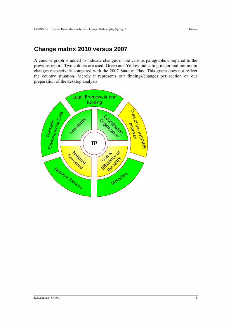
Change matrix 2010 versus 2007
A concise graph is added to indicate changes of the various paragraphs compared to the previous report. Two colours are used: Green and Yellow indicating major and minimum changes respectively compared with the 2007 State of Play. This graph does not reflect the country situation. Merely it represents our findings/changes per section on our preparation of the desktop analysis
Them
atic
En
viro
nmen
tal D
ata Coordination
Organization
National
GeoportalUse
&
Efficien
cy of
the N
SDI
Network Sevices
Data of the IN
SPIRE
annexes
Metadata
Standa
rds
EC-INSPIRE: Spatial Data Infrastructures in Europe: State of play Spring 2010 Turkey
K.U.Leuven (SADL) 2
Executive summary
Based on the website of the Turkish Military Mapping Agency, the GISEE-study and information provided by Prof. Coskun of the Istanbul Technical University, it can be stated that at in Turkey a coherent vision is being developed and related legal initiatives are being prepared to better coordinate production of GI with a view to better satisfy public user needs at all administrative levels. The term SDI is frequently used in the mentioned information sources.
Currently, the Military Mapping Agency is the main data producer, has the most visible internet presence offering limited metadata for its own products. The military character of the agency remains visible in the permits required for using the GI it produces.
Cadastral and other large scale geodata are produced by the (civil) General Directorate of Land Registry and Cadastre. Details on products and services of this Directorate could however not be found. Moreover, GDLRC have created the TAKBIS portal where cadastral solutions and applications are provided (http://takbisbilgi.tkgm.gov.tr/takbis.portal) and a. “Land Register and Cadastre Information System” throughout the country is being available.
There are several persisting problems in the field of GI: lack of coordination between institutions; no standardization with regard to the reference system, the data quality or exchange of data; data duplication; the majority of large scale data not in digital format; interoperability does not (yet) exist; lack of expert personnel and budget; and a lot of difficulties to share data.
Recently the GDLRC and Turksat A.S. have established a project "National Geographic Information Infrastructure" for the use of common purpose of collection and presentation of geographic information by relevant institutions and organizations in Turkey
The act for National Spatial Data Infrastructure (NSDI) is designed in Act Plans for 2006-2010 which is attached to Strategy for National Information Society. NSDI in Turkey is named as “Act 75” under “Modernization in Public Administration”. In this concept two big subprojects are executed.
One of them is Metadata Portal Project where metadata can be register coming from all map related institutions and organizations using ISO 19115 standards http://hbb.tkgm.gov.tr/metadata/.
The other project is CORS-TR (Continuously Operating Reference Stations) Project.
At the same time The Ministry of Environment and Forests provides a number of network services with thematic environmental data.
EC-INSPIRE: Spatial Data Infrastructures in Europe: State of play Spring 2010 Turkey
K.U.Leuven (SADL) 3
Table of Contents CHANGE MATRIX 2010 VERSUS 2007 .................................................................................................. 1 EXECUTIVE SUMMARY .......................................................................................................................... 2 TABLE OF CONTENTS ............................................................................................................................. 3 ABBREVIATIONS AND ACRONYMS..................................................................................................... 4 GENERAL INFORMATION...................................................................................................................... 6
1.1 METHOD ...................................................................................................................................... 6 1.2 THE GI- AND SDI-SCENE IN TURKEY ........................................................................................... 6
2 DETAILS OF THE GI-SECTOR IN TURKEY .................................................................. 7 2.1 GENERAL INFORMATION .............................................................................................................. 7 2.2 COMPONENT 1: COORDINATION AND ORGANIZATIONAL ISSUES ................................................... 8 2.3 COMPONENT 2: LEGAL FRAMEWORK AND FUNDING..................................................................... 9 2.4 COMPONENT 3: DATA FOR THEMES OF THE INSPIRE ANNEXES..................................................13 2.5 COMPONENT 4: METADATA ........................................................................................................18 2.6 COMPONENT 5: NETWORK SERVICES ..........................................................................................20 2.7 COMPONENT 6: THEMATIC ENVIRONMENTAL DATA ....................................................................21 2.8 STANDARDS ................................................................................................................................22 2.9 USE AND EFFICIENCY OF SDI ......................................................................................................22
3 ANNEXES ..............................................................................................................................23 3.1 LIST OF SDI ADDRESSES / CONTACTS FOR TURKEY .....................................................................23 3.2 LIST OF REFERENCES FOR TURKEY..............................................................................................24
EC-INSPIRE: Spatial Data Infrastructures in Europe: State of play Spring 2010 Turkey
K.U.Leuven (SADL) 4
Abbreviations and acronyms ARIP Agricultural Reform Implementation Project CBC Cross Border Collaboration CGM Computer Graphics Metafile CORS Continuously Operating Reference Stations CT Core Thematic Data DSI General Directorate of Hydraulic Works GCM General Command of Mapping GCP Ground Control Points GDLRC General Directorate of Land Registry and Cadastre GDRS General Directorate of Rural Services GI Geographical Information GIS Geographical Information System GISEE GIS Technology and Market in South Eastern Europe GPS Global Positioning System HBB Map Information Bank ICT Information and Communication Technologies ICU Istanbul Culture University INSPIRE INfrastructure for SPatial InfoRmation in Europe IPA Instrument for Pre-Accession Assistance ISO International Organization for Standardization LIS Land Information Systems LRCD Land Registry and Cadastre Directorate (or GDLRC) LSMMIPR Large Scale Maps and Map Information Production Regulation MoEF Ministry of Environment and Forest MPMC Map Production Monitoring Centre MPWS Ministry of Public Works and Settlement MTA General Directorate of Mineral Research and Exploration NSDI National Spatial Data Infrastructures NTGIS National Transit Geographic Information System PSI Policy and legislation on access to public sector information PPP Public-private partnerships REF Reference data RTK Stationary Real-Time Kinematic SDI Spatial Data Infrastructures SIS State Institute of Statistics TABIS Disaster Information System of Turkey
EC-INSPIRE: Spatial Data Infrastructures in Europe: State of play Spring 2010 Turkey
K.U.Leuven (SADL) 5
TABKIS Turkey’s Land Registry and Cadastre Information system TÜBİTAK Scientific and Technological Research Council of Turkey TUTGA National Primary GPS Network of Turkey UVDF National Spatial data Exchange Standard
EC-INSPIRE: Spatial Data Infrastructures in Europe: State of play Spring 2010 Turkey
K.U.Leuven (SADL) 6
GENERAL INFORMATION
1.1 Method
This report is summarizing the SDI review for Turkey, and aims at reflecting the degree to which the SDI situation in Turkey is similar to the ideas set out in the INSPIRE position papers1 and in the more recent INSPIRE scoping documents.
The 2002 report provided general information only which was retrieved from the limited English portion of a number of websites and readily available documents (see Section 3.2 for the list of references). The technical issues have been elaborated to a very limited extent due to lack of accessible information. Some feedback from a Turkish expert was received for the 2004 version of the report. Also the GISEE-final report on the SDI in Turkey was consulted. Both sources of information are rather confusing however. The update of 2005 was based on screening of new information on the legal issues only. The update for 2006 was based on information obtained from presentations at the workshop “Preparing the National INSPIRE Information Days” (organized by JRC for the new and candidate Member States).
For the 2009 update the various web sources and publications were used. In this version obsolete information was removed, while a conclusion paragraph regarding the status of each indicator was added for each component.
1.2 The GI- and SDI-scene in Turkey
SDI-like activities at the national level are mainly with the General Command of Mapping, depending of the Ministry of National Defence (GCM). A condensed version in English of the GCM web site is available at http://www.hgk.mil.tr/english/english.htm . GCM produces a variety of topographic map products at scales 1:25.000 and smaller, aerial and orthophotographs. It is in the process of converting them to digital form with already a number of series being available as raster and vector data. GCM have changed its website to http://www.hgk.msb.gov.tr/index.asp and has turned into a civil national mapping agency. GCM is the Turkish member of Eurogeographics.
For scales 1:25.000 and larger scaled mapping, an important role is played by the General Directorate of Land Registry and Cadastre (GDLRC) (http://www.tkgm.gov.tr) and by the General Directorate of Provinces (http://www.ilbank.gov.tr/). GDLRC has developed Turkey’s Land Registry and Cadastre Information system TABKIS together with an accompanying portal (http://takbisbilgi.tkgm.gov.tr/takbis.portal).
All provinces and many municipalities have a presence on the internet. They are users and producers of GI.
1 INSPIRE position papers, final versions: RDM, ETC, DPLI, ASF, IST, IAS (latest version).
EC-INSPIRE: Spatial Data Infrastructures in Europe: State of play Spring 2010 Turkey
K.U.Leuven (SADL) 7
The private sector is mainly active in contracting work for municipalities for large scale mapping
An important actor in the research/service sector includes the Istanbul Technical University (http://www.itu.edu.tr) which provides Satellite data as SPOT and RADARSAT and operates a Satellite Ground Receiving Station.
NTGIS, is the recent national association for GI. It will cover the whole GI community. It will adopt the role to open up a discussion forum for various national and international GI topics and to promote SDI.
A variety of projects supporting Land Information Systems (LIS) were taken into effect by LRCD, such as Land Registry and Cadastre Information System (TAKBIS), The Continuously Operating Reference Stations -Turkey (CORS-TR), Map Information Bank (HBB), Land Registry Archive Information System (TARBİS), and Agriculture Reform Implementation Project (ARIP). As one aspect of SDI, LRCD collects and manages land registry and cadastre data with all sub-directorates in Turkey, including 22 of Regional Directorates, 1018 of Land Registry Directorates, 325 of Cadastre Directorates, and 122 of Cadastre offices (Mataraci et al., 2009).
2 Details of the GI-sector in Turkey
2.1 General information
In 1999 a governmental commission presented a vision paper for the National Geographic Information Infrastructure of Turkey, and there have been further updates of this document. The Prime Ministry State Institute of Statistics is in the process to develop an NSDI project plan. The purpose of the plan will be to identify the basic geographic datasets and to formally coordinate the production of these datasets to ensure their availability. GCM has a crucial role in this plan (Coskun, 2003).
Currently the GDLRC and Turksat A.S. have established a project "National Geographic Information Infrastructure" for the use of common purpose of collection and presentation of geographic information by relevant institutions and organizations in Turkey. With the protocol signed on December 16, 2009, the project's feasibility study has been initiated. Under the Project, by establishing geographic information systems infrastructure at the national level and appropriate technological developments, responsible public institutions and organizations will submit their geographic information and specified content and exchange standards to respond to the needs of institutions and sector users.
At the same time, Turkey's Geographic Information Infrastructure is predicted to be prepared in accordance with the International standards of the European Union's INSPIRE Directive. It is further envisaged that copyright and access rights, such as pricing issues will be resolved, and that e-government applications will be completed in spatial component (http://www.turksat.com.tr/english/v2/news-room/2010/february/18/id/48).

EC-INSPIRE: Spatial Data Infrastructures in Europe: State of play Spring 2010 Turkey
K.U.Leuven (SADL) 8
Turksat is a private firm, though government-owned – operator of Turkey’s communication satellite system and distributor of satellite-based remote sensing data (via an on-line portal). The company’s ICT Division also has the mandate to coordinate implementation of Turkey’s e- Government programme, under which more than 110 projects are now being developed as part of the Turkish government’s Information Society plans. The Turkish NSDI programme falls under this e-Government umbrella.
Information of the project along with the future geoportal structure can be found (in Turkish) at: http://www.turksatglobe.com/Views/Geoportal/CBSATanim.aspx?ContentId=0.
2.2 Component 1: coordination and organizational issues
There are two primary governmental organizations working on the Turkish NSDI at the national level: the Coordination and Planning Committee for Map Works among Ministries and the Prime Ministry State Planning Organization – Information Society Department.
The lack of coordination between institutions is one of the problems for the development of the SDI.
The act for National Spatial Data Infrastructure (NSDI) is designed in Act Plans for 2006-2010 which is attached to Strategy for National Information Society. NSDI in Turkey is named as “Act 75” under “Modernization in Public Administration”. In this concept two big subprojects are executed.
One of them is Metadata Portal Project. Currently the system design and software studies are completed. The portal can register their metadata from all map related institutions and organizations using ISO 19115 standards and to search to all people on http://hbb.tkgm.gov.tr/metadata/.
The other project is CORS-TR (Continuously Operating Reference Stations) Project. Within the scope of this project, Istanbul Culture University (ICU), jointly with the General Command of Mapping (GCM) and the General Directorate of Land Registry and Cadastre (GDLRC), has proposed an extremely crucial project for Turkey to TÜBİTAK (The Scientific and Technological Research Council of Turkey).
TÜBİTAK is also preparing the “Project of Research and Implementation Related to the Establishment of Network based Stationary Real-Time Kinematic (RTK) GPS Terminals and Determination of Cellular Transformation Parameters”. The aim is to establish one station in each province, in order to provide a system that will cover the whole country, functioning 24 hours/day, and able to provide the capability of accurate position determination (Bakiki and Erkek, 2009).
2.2.1 Conclusions of Component 1

EC-INSPIRE: Spatial Data Infrastructures in Europe: State of play Spring 2010 Turkey
K.U.Leuven (SADL) 9
The Turkish SDI approach is truly national. SDI building blocks though have not yet reached a significant level of operationality. The act for National Spatial Data Infrastructure is designed in Act Plans for 2006-2010 which is attached to Strategy for National Information Society. NSDI in Turkey is named as “Act 75” under “Modernization in Public Administration”. Currently the GDLRC and Turksat A.S. have established a project "National Geographic Information Infrastructure" for the use of common purpose of collection and presentation of geographic information by relevant institutions and organizations in Turkey. With the protocol signed on December 16, 2009, the project's feasibility study has been initiated. Turksat is a private firm, though government-owned.
Based on these conclusions we score the indicators as follows:
• The approach and territorial coverage of the SDI is truly national
• One or more components of the SDI have reached a significant level of operationality (No)
• The officially recognised or de facto coordinating body of the SDI is a NDP, i.e. a
NMA or a comparable organisation (Not so clear)
• The officially recognised or de facto coordinating body for the SDI is an organisation controlled by data users (Not so clear)
• An organisation of the type ‘national GI-association’ is involved in the
coordination of the SDI (No)
• Producers and users of spatial data are participating in the SDI (Not so clear)
• Only public sector actors are participating in the SDI
2.3 Component 2: Legal framework and funding
2.3.1 Legal framework
Turkey is currently working on implementing a strategy for the NSDI and preparing a proposal for a law on the spatial data infrastructure.
The Prime Ministry for State Planning and Organization proposed a number of Action Items in the course of the e-Transformation Turkey Initiative during 2005 and 2006, to prepare the set-up of the NSDI:
EC-INSPIRE: Spatial Data Infrastructures in Europe: State of play Spring 2010 Turkey
K.U.Leuven (SADL) 10
Action Item 47 (A Preliminary Work to setup the National GIS / NSDI) (Dec 4, 2003 –Feb 2005): this action item included a survey of stakeholders, the identification of problems and recommendations. The study was executed by the General Directorate of Land Registry and Cadastre, in cooperation with public bodies, universities, the private sector and the municipalities (G. Yalcin, B. Erkek, S. Bakici and N. Ahn, Through Spatial Data Infrastructure in Turkey, http://www.fig.net/pub/fig2009/papers/ts01b/ts01b_yalcin_etal_3460.pdf).
Action Item 36 (Policy& Strategy Document of the National GIS/NSDI) (May 2005 –Feb 2006). The goals of this item were to determine standards for classification data, metadata, producing, storing and sharing data; to prepare a strategy document, and to determine the requirements for the legal framework.
This action item led to the following SDI vision: “to allow geospatial data users in our country on-line access to quality and up-to-ate geospatial information they need for their geo-related decision support processes, projects and applications”. It identified responsibilities for the different data categories, and gave recommendations on standards and metadata.
It proposed an independent national Committee for NSDI, and a special SDI unit within the National Mapping and Cadastral Agency. A strategy in 6 stages was proposed:
o STAGE 1: Realize legal regulation covering Policy, data content and organizational responsibilities for the NSDI.
o STAGE 2: Develop the National Spatial data Exchange Standard (UVDF) in compliance with ISO standards.
o STAGE 3: Let the institutions prepare geospatial metadata for their area of responsibility and present at their metadata portals.
o STAGE 4: Let the NSDI Organizational Infrastructure (e.g. Committee or Unit) prepare geospatial data standards according to the NSDI policy and strategy document (i.e. Action Item 36 –Report)
o STAGE 5: Let the institutions prepare geospatial data for their area of responsibility.
o STAGE 6: Let the institutions present their data their data portals according to the legal framework defined at Stage 1.
Action Item 75 (Creating National GIS Infrastructure/ NSDI) - (Jul 2006 –Dec 2007) was the result of the National Information Society Strategy and its Action Plan for 2006-2010. Its objective was the establishment of the Geographic Information Infrastructure.
Next to these Action items, the following instruments are also important:

EC-INSPIRE: Spatial Data Infrastructures in Europe: State of play Spring 2010 Turkey
K.U.Leuven (SADL) 11
Municipality Law 5216 and Metropolitan Law 5272 oblige municipalities to build GIS and urban GIS
Interoperability circular 2005: this contains standards to build information systems in all central and local public institutions (A. Aydinoglu, W. Quak, T. Yomralioglu, Some Spatial Data Management Issues towards Building SDI, http://www.i3mainz.fh-mainz.de/FIG-Workshop/programme2-Dateien/TS%206.2_Aydinoglu,etc._Some%20Spatial%20Data%20Management%20Issues%20towards%20Building%20SDI.pdf)
2005 Cadastre law: this law gives a mandate to create the Turkish NSDI.
2.3.2 Public-private partnerships (PPPs)
PPPs between the public and the private sector for the operation of the cadastre are accepted in theory, but are not fully operational yet. The government is working together with the company Turksat to develop the Turkish SDI.
2.3.3 Policy and legislation on access to public sector information (PSI)
The Turkish law on the right to information dates from October 9, 2003. The object of the law is to regulate the procedure of the right to information according to the principles of equality, impartiality and openness that are the necessities of a democratic and transparent government. Next to the Act, a circular on 'The exercise of the right of petition and access to information' was issued by The Prime Ministry in 2004 (see http://www.epractice.eu/en/document/288415).
The law on the right to information gives natural and legal persons the right to obtain information from public institutions and private organisations that qualify as public institutions.
2.3.4 Legal protection of GI by intellectual property rights
Turkey has had a modern copyright law since 1951. It was amended in 1995 in order to harmonize it with European Union copyright principles. The amended Copyright Law contains a number of significant improvements: expanding the term of protection to 70 years, broadening coverage to include software, and sharply increasing penalties for infringement. However, further amendments are needed to bring the law into compliance with TRIPs, Berne. In 2001, the Copyright law was amended in order to make it more compliant with international conventions.
2.3.5 Restricted access to GI further to the legal protection of privacy
Section Five of the 1982 Turkish Constitution is entitled “Privacy and Protection of Private Life”. Article 20 of the Turkish Constitution deals with the “Privacy of the Individual’s Life”, whilst article 22 deals with the “Secrecy of communication”.
EC-INSPIRE: Spatial Data Infrastructures in Europe: State of play Spring 2010 Turkey
K.U.Leuven (SADL) 12
The Turkish Ministry of Justice has been working on data protection legislation for several years without success. In mid 2003, a draft law on the protection of personal data (Kisisel Verilerin Korunmasi Kanunu Taslagi) was completed. It is based on the 1981 Council of Europe Convention and Directive 95/46 on the protection of personal data. The draft was sent to the National Assembly in 2008, and it is still pending (http://www.epractice.eu/en/document/288415). The By-law on privacy in the telecommunications sector was adopted in 2004 and the By-law on electronic communication security in 2008.
2.3.6 Licensing framework
GISEE (2004, p.30) states that the use of small and medium scale data (presumably the data provided by the GCM) requires permission from the military. No more recent information has been found.
2.3.7 Funding model for the SDI and pricing policy
Funding of data production and related services is mainly by the central government and, to a limited extent, by international donors (GISEE, 2004). No more recent information has been found.
2.3.8 Conclusions of Component 2 Turkey is currently working on implementing a strategy for the NSDI and preparing a proposal for a law on the spatial data infrastructure. The government is working together with the company Turksat to develop the Turkish SDI. Funding of data production and related services is mainly by the central government and, to a limited extent, by international donors. Based on these conclusions we score the indicators as follows:
• There is a legal instrument or framework determining the SDI-strategy or –development (In Preparation)
• There are true PPP’s or other co-financing mechanisms between public and
private sector bodies with respect to the development and operation of the SDI-related projects (No Information found)
• There is a freedom of information (FOI) act which contains specific FOI
legislation for the GI-sector (No Information found)
• GI can specifically be protected by copyright (No Information found)
• Privacy laws are actively being taken into account by the holders of GI (No Information found)

EC-INSPIRE: Spatial Data Infrastructures in Europe: State of play Spring 2010 Turkey
K.U.Leuven (SADL) 13
• There is a framework or policy for sharing GI between public institutions (No
Information found)
• There are simplified and standardised licences for personal use (No Information found)
• The long-term financial security of the SDI-initiative is secured (No)
• There is a pricing framework for trading, using and/or commercialising GI (No
Information found)
2.4 Component 3: Data for themes of the INSPIRE annexes
2.4.1 Scale and Resolution
GCM produces topographic maps and related digital raster and vector products at scales 1:25.000, 1:50.000, 1:100.000, 1:250.000, 1:500.000 and 1:1.000.000.
Large Scaled Maps, 1/5000 and larger, are produced by (LRCD) and State Provincial Bank. Other public institutions and municipalities also produce maps serving their own needs, depending on their responsibilities and rights legalized by the laws.
The current situation of cadastre works are presented in number of units (districts in urban areas and villages in rural areas) and their percentages. Figure 1 shows the distribution of units where cadastre works are completed, continuing or remaining.
Completed and continuing works indicate 98% of cadastre coverage (Mataraci et al., 2009).
Table 1. Realization of the Turkish cadastral works (LRCD, 2009)
2.4.2 Data by resolution or scale range for the INSPIRE themes
The GCM website announces following digital geodatasets:
EC-INSPIRE: Spatial Data Infrastructures in Europe: State of play Spring 2010 Turkey
K.U.Leuven (SADL) 14
1 : 25 000 Scale Digital Elevation Maps (YUKPAF25)
1 : 250 000 Scale Digital Elevation Maps (YUKPAF250)
1 : 25 000 Scale Raster Maps (RHEG25)
1 : 50 000 Scale Raster Maps (RHEG50)
1 : 100 000 Scale Raster Maps (RHEG100)
1 : 250 000 Scale Raster Maps (RHEG250)
1 : 500 000 Scale Raster Maps (RHEG500)
1 : 1 000 000 Scale Raster Maps (RHEG1000)
3" x 3" Digital Terrain Data (DTED1)
1" x 1" Digital Terrain Data (DTED2
The 1:25.000 scale digital elevation maps contain the contour lines (5 meter interval), elevation points and their heights as derived from the 1:25.000 topographic maps. The spatial coverage is not clear (populating database about to start).
The 1" x 1" Digital Terrain Dataset comprises the terrain elevations defined by points in intervals of 1" latitude and 1" longitude, as derived from the contour lines and elevation spots at the 1:25.000 topographic map. Again spatial coverage is not specified.
According to GISEE (2004), few geodatasets have complete national coverage.
Topographic Database at scale 1:25.000 (CGM): vector data collection, seem to be completed and available for sale among other products at: http://www.hgk.msb.gov.tr/urunler/satis.asp. Topographic Database at scale 1:250.000 (CGM): vector data collection completed. Derived from VMAP-1. Data dissemination at map sheet level; e-commerce started in 2006. National feature attribute catalogue for both products. A gazetteer and place names database is completed for the whole of Turkey.
Work is going on in the following fields, of which several are themes of the annexes of the INSPIRE Directive:
Land Registry & Cadastre Information System (TAKBIS) by General Directorate of Land Registry and Cadastre: http://takbisbilgi.tkgm.gov.tr/takbis.portal;
Agricultural Reform Implementation Project (ARIP) by General Directorate of Land Registry and Cadastre: http://www.tkgm.gov.tr/turkce/dosyalar/diger/proje12.doc;
National Topographic Databases (vector, raster, gazetteer) by General Command of Mapping): http://www.hgk.mil.tr/english/english.htm;
e-Commerce of Geospatial Information by General Command of Mapping: http://www.hgk.mil.tr/english/english.htm;

EC-INSPIRE: Spatial Data Infrastructures in Europe: State of play Spring 2010 Turkey
K.U.Leuven (SADL) 15
International e-Roads, Trans European South-North Motorway Project, Trans Turkey Highway Project by General Directorate of Highways: http://www.kgm.gov.tr/Sayfalar/KGM/SiteEng/Root/MainPageEnglish.aspx;
Geologic Data Bases (vector) by General Directorate of Mineral Research & Exploration: http://www.mta.gov.tr/v1.0/english/index.php /;
Biological Diversity & Natural Resource Management Project by General Directorate of Environmental Protection & National Parks: http://www.gef-2.org/tr/index.asp;
Forest Resource Information System by General Directorate of Forestry: http://www.ogm.gov.tr/birim12_2.htm;
National Information System and Statistical Development Project by Turkish Statistical Institute: http://www.die.gov.tr/PROJECTS/NIS/nis.html;
Soil & Water Resources National Information Centre by General Directorate of Rural Services: http://www.khgm.gov.tr/nic.htm;
Turkey Flood and Earthquake Recovery Project by General Directorate of State Water Works: http://www.dsi.gov.tr/english/service/cevree.htm;
Disaster Information System of Turkey (TABIS) by General Directorate of Disaster Affairs: http://www.deprem.gov.tr/Sarbis/Shared/Anasayfa.aspx.
The majority of the large scale maps (=< 1:5.000) are not in digital format.
Regarding the three INSPIRE annexes addressing the 34 spatial data themes, a complete list will be presented in the updated report including the information provided by the country in 2010.
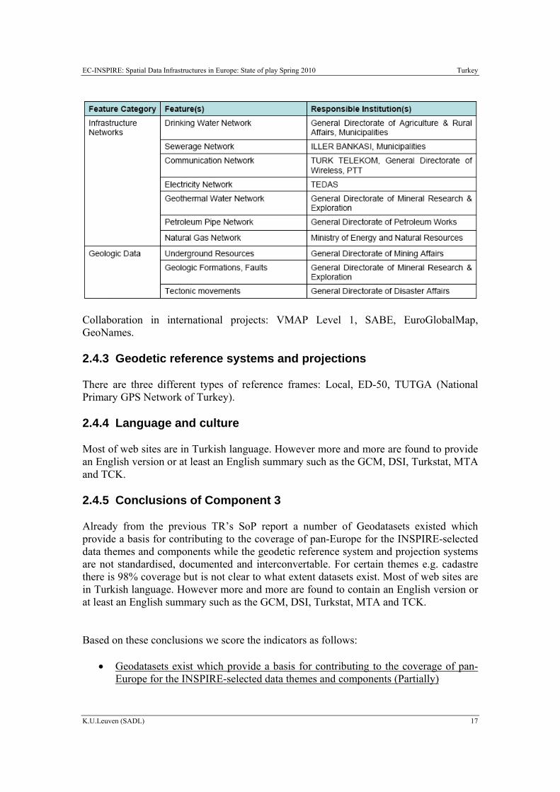
Responsibilities for the different data themes:

EC-INSPIRE: Spatial Data Infrastructures in Europe: State of play Spring 2010 Turkey
K.U.Leuven (SADL) 16
EC-INSPIRE: Spatial Data Infrastructures in Europe: State of play Spring 2010 Turkey
K.U.Leuven (SADL) 17
Collaboration in international projects: VMAP Level 1, SABE, EuroGlobalMap, GeoNames.
2.4.3 Geodetic reference systems and projections
There are three different types of reference frames: Local, ED-50, TUTGA (National Primary GPS Network of Turkey).
2.4.4 Language and culture
Most of web sites are in Turkish language. However more and more are found to provide an English version or at least an English summary such as the GCM, DSI, Turkstat, MTA and TCK.
2.4.5 Conclusions of Component 3
Already from the previous TR’s SoP report a number of Geodatasets existed which provide a basis for contributing to the coverage of pan-Europe for the INSPIRE-selected data themes and components while the geodetic reference system and projection systems are not standardised, documented and interconvertable. For certain themes e.g. cadastre there is 98% coverage but is not clear to what extent datasets exist. Most of web sites are in Turkish language. However more and more are found to contain an English version or at least an English summary such as the GCM, DSI, Turkstat, MTA and TCK.
Based on these conclusions we score the indicators as follows:
• Geodatasets exist which provide a basis for contributing to the coverage of pan-Europe for the INSPIRE-selected data themes and components (Partially)

EC-INSPIRE: Spatial Data Infrastructures in Europe: State of play Spring 2010 Turkey
K.U.Leuven (SADL) 18
• The geodetic reference system and projection systems are standardised,
documented and interconvertable (No)
• There is a documented data quality control procedure applied at the level of the SDI (No Information found)
• Concern for interoperability goes beyond conversion between different data
formats (No Information found)
• The national language is the operational language of the SDI
• English is used as secondary language (Partially)
2.5 Component 4: Metadata
The GCM website http://www.hgk.msb.gov.tr/urunler/satis.asp provides a description of the offered analogue and digital products.
According to GISEE (2004), metadata are available for a significant part of the major geodatasets. These are however mostly not according to some standard. Few are available on-line.
“Metadata Portal for Maps” that is named as “Map Information Bank” is established by General Directorate of Land Registry and Cadastre (GDLRC). The aim is to Monitor Map Production in Turkey in one way and to prevent duplicate mapping activities. Metadata Portal in Map Production Monitoring Centre (MPMC) is based on Articles 103, 104 and 105 in Large Scale Maps and Map Information Production Regulation (LSMMIPR) legally and the duty to establish this metadata portal is referred to GDLRC. Technically MPMC is embedded in Information System for Land Registry and Cadastre (TAKBIS). In this scope a web based prototype has been developed. All institutions that are dealing with map production in Turkey are members of this study.
The web interface is designed accordance to the ISO 19115/TC 211 Digital Geographic Information System Standards. MPMC data sets and web services are saved in GIS PORTAL TOOLKIT of ESRI.
Users can directly connect ArcIMS Web Service to present geographic data and ArcSDE/SQL Server is used as database.
The general options of the Metadata User Interface is register, publish, query and access to the spatial information. At the same time the type of functions on Metadata User Interface are: Administration functions, online metadata registration functions, query
EC-INSPIRE: Spatial Data Infrastructures in Europe: State of play Spring 2010 Turkey
K.U.Leuven (SADL) 19
metadata functions. In addition to these Ground Control Points (GCP) Function is developed to search information related to GCP. Metadata and GCPS are integrated with Google Earth to provide broad visual capabilities (Yalçın and Bakıcı, 2008).
The portal website is http://hbb.tkgm.gov.tr/metadata/MetadataSearch.aspx?Deger=1 (only in Turkish). As stated by Mataraci et al., 2009 the current condition of the project is:
The education is provided to the other map related public institutions and entry of metadata has started.
Entry of metadata of 1/5000 scale Standard Topographic Map is completed.
The updating of the Sheet Registration System and then the integration to MPFC are aimed for metadata of cadastral sheets.
Searching Ground Control Points (with Datum ED50 and ITRF) is possible.
Metadata areas and Ground Control Points are integrated with Google Maps.
Currently, organizations producing large scale map have been continuing submission of their data by using web based Map Information Bank Interface.
2.5.1 Conclusions of Component 4 Turkey is currently running projects to intensify and unify the metadata production. For example, the “Metadata Portal for Maps” that is named as “Map Information Bank” is established by General Directorate of Land Registry and Cadastre (GDLRC). The aim is to Monitor Map Production in Turkey in one way and to prevent duplicate mapping activities. Metadata Portal in Map Production Monitoring Centre (MPMC) is based on Articles 103, 104 and 105 in Large Scale Maps and Map Information Production Regulation (LSMMIPR) legally and the duty to establish this metadata portal is referred to GDLRC. Technically MPMC is embedded in Information System for Land Registry and Cadastre (TAKBIS). In this scope a web based prototype has been developed. All institutions that are dealing with map production in Turkey are members of this study. On test phase at the moment and only in Turkish the portal http://hbb.tkgm.gov.tr/metadata/MetadataSearch.aspx?Deger=1. Based on these conclusions we score the indicators as follows:
• Metadata are produced for a significant fraction of geodatasets of the themes of the INSPIRE annexes (Partially)
• One or more standardised metadata catalogues are available covering more than
one data producing agency (No)
• There is a coordinating authority for metadata implementation at the level of the SDI (No)
EC-INSPIRE: Spatial Data Infrastructures in Europe: State of play Spring 2010 Turkey
K.U.Leuven (SADL) 20
2.6 Component 5: Network Services
The GCM website http://www.hgk.mil.tr/english/english.htm provides a description of the offered analogue and digital products. GISEE mentions this web site as the most comprehensive geo-portal in Turkey.
A number of portals exist, mainly dispersed to its institutions while most of them deal with environmental data. The Ministry of Environment and Forests and its department of Information Technology, provide a GIS geodata services (in Turkish) at http://gis.cevreorman.gov.tr/sayfalar/ana_sayfa.html. A number of data layers are available as well as the GIS map functionalities such as zoom in/out, info, crop, take a snapshot etc.
The ministry also provides the:
http://www.yildizdagiprojesi.cevreorman.gov.tr/cob2/denemetestpage.aspx portal and the http://agmcas.cevreorman.gov.tr/COB/MainPageFW/index2.aspx?HideMenus=1.
The portal requires Microsoft silverlight to be installed.
Moreover, GDLRC have created the Takbis portal where cadastral solutions and applications are provided (http://takbisbilgi.tkgm.gov.tr/takbis.portal). TARBİS project collects all land registry titles on digital format and indexes all titles since Ottoman Empire. The project is creating a “Land Register and Cadastre Information System” throughout the country.
Main objectives of TAKBİS are providing accurate, valid and reliable land information required for land and land – related activities of decision markers, transforming land register and cadastral survey works and associated information into a multi – purpose land information system. So far, 370 land registry offices and 32 cadastre offices have been integrated with the TAKBİS. In these land registry offices, information on 25 million real estates and 45 million active right holders (owners) has been integrated with the TAKBİS (Mataraci et al., 2009).
2.6.1 Conclusions of Component 5 A number of portals exist, mainly dispersed to its institutions while most of them deal with environmental data. .The Ministry of Environment and Forests and its department of Information Technology, provide a GIS geodata services (in Turkish) at http://gis.cevreorman.gov.tr/sayfalar/ana_sayfa.html. A number of data layers are available Based on these conclusions we score the indicators as follows:
EC-INSPIRE: Spatial Data Infrastructures in Europe: State of play Spring 2010 Turkey
K.U.Leuven (SADL) 21
• There are one or more discovery services making it possible to search for data and services through metadata (Not so clear)
• There are one or more view services available for to visualise data from the
themes of the INSPIRE annexes (Not so clear)
• There are one ore more on-line download services enabling (parts of) copies of datasets (No)
• There are one or more transformation services enabling spatial datasets to be
transformed to achieve interoperability (No information found)
• There are middleware services allowing data services to be invoked (No information found)
2.7 Component 6: Thematic environmental data
MTA (Mineral Research & Exploration General Directorate), established in 1935 with the aim of conducting scientific and technological research on mineral exploration. It provides a number of Geology, Geophysics, and Mineral maps (http://www.mta.gov.tr/v1.0/english/maps.php).
The Ministry of Environment and Forests has the responsibility for co-ordinating the studies conducted related to the Environment Chapter of EU legislation. The Law on Establishment and Duties of Ministry of Environment and Forestry No. 4856 (Official Gazette: 08 May 2003, No. 25102) defines the mandate of the MoEF as identifying appropriate technologies for environmental protection and pollution prevention; setting the environmental standards and develop waste management policies among other duties (http://www.cevreorman.gov.tr/COB/Bakanlik/bakanlikGorevleri.aspx?sflang=en).
The ministry regulates its own GIS department (http://gis.cevreorman.gov.tr/sayfalar/ana_sayfa.html).
A number of web map services and datasets are available in the ministry website (http://gis.cevreorman.gov.tr/cob/index.aspx) providing Water data, Meteorological data, Forest and Preserved Areas.
2.7.1 Conclusions of Component 6 A number of web map services and datasets are available in the ministry website (http://gis.cevreorman.gov.tr/cob/index.aspx) providing Water data, Meteorological data, Forest and Preserved Areas..

EC-INSPIRE: Spatial Data Infrastructures in Europe: State of play Spring 2010 Turkey
K.U.Leuven (SADL) 22
Based on the information provided on the previous paragraph we score the indicator as follows:
• Thematic environmental data are covered by the described SDI-initiative or there is an independent thematic environmental SDI (Partially)
2.8 Standards
Metadata portal web interface is designed accordance to the ISO 19115/TC 211 Standards. MPMC data sets and web services are saved in GIS PORTAL TOOLKIT of ESRI. (Yalçin et al., 2010).
2.8.1 Conclusions of Component 7 Based on the information provided on the previous paragraph we score the indicator as follows:
• The SDI-initiative is devoting significant attention to standardisation issues (Partially)
2.9 Use and efficiency of SDI
Since Turkey has not yet an established SDI is not easy to pinpoint areas of usage and efficiency on the different sectors. Apart from obvious data/maps availability a major efficiency example would be the Cross Border Collaborations established such as the Bulgaria - Turkey IPA Cross-border Programme which is financed by the European Union through the IPA (Instrument for Pre-Accession Assistance) Fund and co-financed by Bulgaria and Turkey through contributions from state budgets.
Furthermore, Turkey participates in the ENCI CBC (Cross Border Collaboration) Sea-Basin Programme 2007-2013 Black Sea (http://www.ipacbc-bgtr.eu/eng/page/programme/strategic_goals).
EC-INSPIRE: Spatial Data Infrastructures in Europe: State of play Spring 2010 Turkey
K.U.Leuven (SADL) 23
3 Annexes
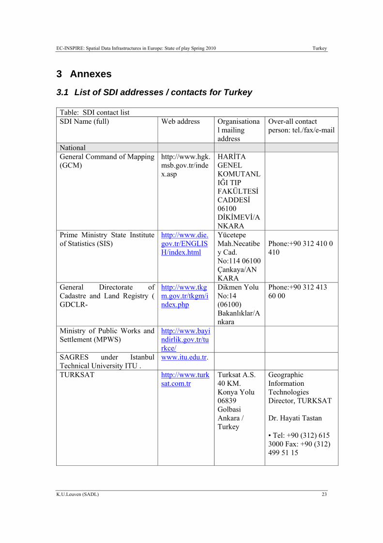
3.1 List of SDI addresses / contacts for Turkey Table: SDI contact list SDI Name (full) Web address Organisationa
l mailing address
Over-all contact person: tel./fax/e-mail
National General Command of Mapping (GCM)
http://www.hgk.msb.gov.tr/index.asp
HARİTA GENEL KOMUTANLIĞI TIP FAKÜLTESİ CADDESİ 06100 DİKİMEVİ/ANKARA
Prime Ministry State Institute of Statistics (SIS)
http://www.die.gov.tr/ENGLISH/index.html
Yücetepe Mah.Necatibey Cad. No:114 06100 Çankaya/ANKARA
Phone:+90 312 410 0 410
General Directorate of Cadastre and Land Registry ( GDCLR-
http://www.tkgm.gov.tr/tkgm/index.php
Dikmen Yolu No:14 (06100) Bakanlıklar/Ankara
Phone:+90 312 413 60 00
Ministry of Public Works and Settlement (MPWS)
http://www.bayindirlik.gov.tr/turkce/
SAGRES under Istanbul Technical University ITU .
www.itu.edu.tr.
TURKSAT http://www.turksat.com.tr
Turksat A.S. 40 KM. Konya Yolu 06839 Golbasi Ankara / Turkey
Geographic Information Technologies Director, TURKSAT Dr. Hayati Tastan • Tel: +90 (312) 615 3000 Fax: +90 (312) 499 51 15
EC-INSPIRE: Spatial Data Infrastructures in Europe: State of play Spring 2010 Turkey
K.U.Leuven (SADL) 24
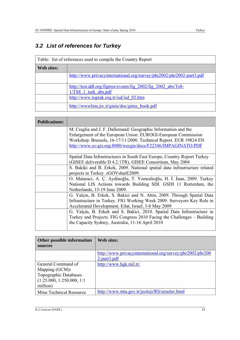
3.2 List of references for Turkey Table: list of references used to compile the Country Report
Web sites:
http://www.privacyinternational.org/survey/phr2002/phr2002-part3.pdf
http://test.ddl.org/figtree/events/fig_2002/fig_2002_abs/Ts8-1/TS8_1_turk_abs.pdf
http://www.toprak.org.tr/isd/isd_02.htm
http://wwwlmu.jrc.it/ginie/doc/ginie_book.pdf
Publications:
M. Craglia and J. F. Dallemand: Geographic Information and the Enlargement of the European Union. EUROGI-European Commission Workshop. Brussels, 16-17/11/2000. Technical Report. EUR 19824 EN http://www.ec-gis.org:8080/wecgis/docs/F22346/IMPAGINATO.PDF
Spatial Data Infrastructures in South East Europe, Country Report Turkey (GISEE deliverable D 4.2.1TR), GISEE Consortium, May 2004
S. Bakiki and B. Erkek, 2009. National spatial data infrastructure related projects in Turkey. eGOVsharE2009.
O. Mataraci, A. Ç. Aydinoğlu, T. Yomralioğlu, H. İ. İnan, 2009. Turkey National LIS Actions towards Building SDI. GSDI 11 Rotterdam, the Netherlands, 15-19 June 2009.
G. Yalçin, B. Erkek, S. Bakici and N. Ahin, 2009. Through Spatial Data Infrastructure in Turkey. FIG Working Week 2009. Surveyors Key Role in Accelerated Development. Eilat, Israel, 3-8 May 2009
G. Yalçin, B. Erkek and S. Bakici, 2010. Spatial Data Infrastructure in Turkey and Projects. FIG Congress 2010 Facing the Challenges – Building the Capacity Sydney, Australia, 11-16 April 2010
Other possible information sources
Web sites:
http://www.privacyinternational.org/survey/phr2002/phr2002-part3.pdf
General Command of Mapping (GCM): Topographic Databases (1:25.000, 1:250.000, 1:1 million)
http://www.hgk.mil.tr/
Mine Technical Resource http://www.mta.gov.tr/jeoloji/RS/urunler.html
EC-INSPIRE: Spatial Data Infrastructures in Europe: State of play Spring 2010 Turkey
K.U.Leuven (SADL) 25
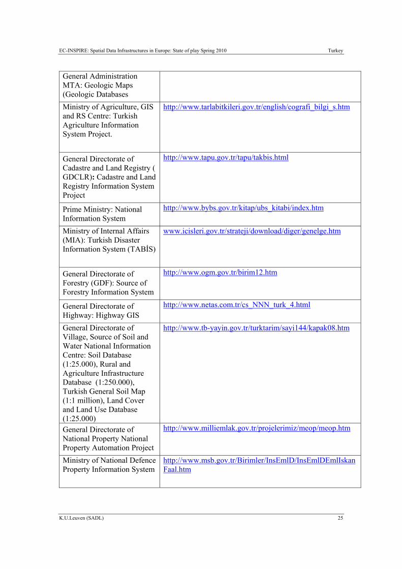
General Administration MTA: Geologic Maps (Geologic Databases Ministry of Agriculture, GIS and RS Centre: Turkish Agriculture Information System Project.
http://www.tarlabitkileri.gov.tr/english/cografi_bilgi_s.htm
General Directorate of Cadastre and Land Registry ( GDCLR): Cadastre and Land Registry Information System Project
http://www.tapu.gov.tr/tapu/takbis.html
Prime Ministry: National Information System
http://www.bybs.gov.tr/kitap/ubs_kitabi/index.htm
Ministry of Internal Affairs (MIA): Turkish Disaster Information System (TABİS)
www.icisleri.gov.tr/strateji/download/diger/genelge.htm
General Directorate of Forestry (GDF): Source of Forestry Information System
http://www.ogm.gov.tr/birim12.htm
General Directorate of Highway: Highway GIS
http://www.netas.com.tr/cs_NNN_turk_4.html
General Directorate of Village, Source of Soil and Water National Information Centre: Soil Database (1:25.000), Rural and Agriculture Infrastructure Database (1:250.000), Turkish General Soil Map (1:1 million), Land Cover and Land Use Database (1:25.000)
http://www.tb-yayin.gov.tr/turktarim/sayi144/kapak08.htm
General Directorate of National Property National Property Automation Project
http://www.milliemlak.gov.tr/projelerimiz/meop/meop.htm
Ministry of National Defence Property Information System
http://www.msb.gov.tr/Birimler/InsEmlD/InsEmlDEmlIskanFaal.htm
EC-INSPIRE: Spatial Data Infrastructures in Europe: State of play Spring 2010 Turkey
K.U.Leuven (SADL) 26
Ministry of Environment (ME) National Environment Database
http://www.tai.com.tr/homepage.swf
http://test.ddl.org/figtree/events/fig_2002/fig_2002_abs/Ts8-1/TS8_1_turk_abs.pdf
http://www.toprak.org.tr/isd/isd_02.htm