Spatial Data Infrastructures in Norway State of play...
50
Spatial Data Infrastructures in Norway : State of play Autumn 2006 Country report on SDI elaborated in the context of a study commissioned by the EC (EUROSTAT) in the framework of the INSPIRE initiative (Under Framework Contract REGIO/G4-2002-02-Lot 2) December 2006 SPATIAL APPLICATIONS DIVISION K.U.LEUVEN RESEARCH & DEVELOPMENT Celestijnenlaan 200 E, BE-3001 LEUVEN TEL.: 32 16 32 97 32 FAX: 32 16 32 97 24 URL: http://www.sadl.kuleuven.be
Transcript of Spatial Data Infrastructures in Norway State of play...

Spatial Data Infrastructures in Norway: State of play Autumn 2006
Country repor t on SDI e laborated in the context of a s tudy commiss ioned by the EC (EUROSTAT) in the f ramework of the INSPIRE in i t ia t ive
(Under Framework Contract REGIO/G4-2002-02-Lot 2) December 2006
SPATIAL APPLICATIONS DIVISION K.U.LEUVEN RESEARCH & DEVELOPMENT
Celestijnenlaan 200 E, BE-3001 LEUVEN TEL.: 32 16 32 97 32 FAX: 32 16 32 97 24 URL: http://www.sadl.kuleuven.be

Report meta-information
Title Spatial Data Infrastructures in Norway: State of Play Autumn 2006
Creator Margaret Hall & Peter Beusen (ICRI)
Date Issued 2003-07-25
Subject INSPIRE State of Play
Publisher K.U.Leuven (SADL + ICRI) + Margaret Hall consultant
Description This report is summarizing the review of SDI in Norway
Contributor Margaret Hall (ind.), Jos Van Orshoven, Catharina Bamps (SADL); Peter Beusen, Katleen Janssen (ICRI); Kari Strande, Mortine Borrebaek, Laila Aslesen (NO-NMA)
Format MS Word 97/2000
Audience INSPIRE stakeholders
Identifier rcr06NOv91.doc
Language EN
Coverage Snapshot at 2006-12-31
Version number Date Modified by Comments
1.0 2002-12-17 Margaret Hall & Peter Beusen (ICRI)
First version
2.0 2002-12-20 Jos Van Orshoven (SADL)
Completion & harmonization with 31 other country reports
3.0 2003-07-25 Margaret Hall Consolidation of completing and correcting remarks received from Kari Strande (National Mapping Authority in cooperation with Morten Borrebaek).; Addition of Executive Summary and abbreviations and acronyms; Reorganisation according to new template

4.0 2003-08-06 Jos Van Orshoven (SADL)
Harmonisation with 31 other country reports
5.0 2004-06-13 Catharina Bamps (SADL)
Integration of information from limited review of web sites
General review, correction and update
Addition of table pointing to changes with regard to version 4.
6.0 2004-06-29 Katleen Janssen (ICRI) General review, correction and update of legal framework
7.0 2004-07-02 Jos Van Orshoven (SADL)
Consolidation
8.0 2005-06-01 Laila Aslesen (NO) Update status 2005
8.1 2005-07-26 Katleen Janssen (ICRI) General review, correction and update of legal framework
8.2 2005-08-05 Danny Vandenbroucke Review of the 2005 update and consolidation
8.3 2005-09-26 Danny Vandenbroucke Final report based on comments from the EU
9.0 2006-12-22 Katleen Janssen (ICRI) General review, correction and update of legal framework
9.1 2006-12-30 Danny Vandenbroucke Review of the 2006 update and consolidation
EC-INSPIRE: Spatial Data Infrastructures in Europe: State of play Autumn 2006 Norway
K.U.Leuven (SADL-ICRI) – REGIO/G4-2002-02-Lot2 1
Change matrix 2006 versus 2005 Paragraphs in which information is reported which deviates in a significant way from what was reported in the Spring 2005 version of this country report are listed in the below table. They are indicated in red.
Paragraph Type of change All Restructure and reword to bring the report more in line with
INSPIRE 1.1 Modify to reflect the 2006 update 2.2 New section on coordination and organizational issues 2.4.1 Modify to reflect the 2006 update 2.4.3 Modify to reflect the 2006 update 2.4.4 Modify to reflect the 2006 update 2.4.5 Modify to reflect the 2006 update 2.5 Modify to reflect the 2006 update

EC-INSPIRE: Spatial Data Infrastructures in Europe: State of play Autumn 2006 Norway
K.U.Leuven (SADL-ICRI) – REGIO/G4-2002-02-Lot2 2
Executive summary Norway is on its way towards having an extensive public NSDI known as “Norway Digital”. Many building blocks and issues are being knit together through a co-ordinated national SDI strategy for which however, no formal dedicated legislation exists. Although many data producers and users are involved, especially at the lower administrative levels a general lack of awareness about NSDI and related policy aspects still prevails.
The NSDI approach in Norway is extensively based on core and agreed standards and specifications (SOSI and ISO). Co-operation on co-financing, and jointly executed projects for establishing, improving and maintaining large scale and environmental digital geographic data are crucial.
Cooperation and coordination are essential features. To this end the Norwegian NSDI is providing for the collection and co-ordination of key elements built around a core of geographic information and services. These elements are policy and guidelines, standards, competence and education, partnership and co-operation and core data.
The NSDI is building upon various national level programmes including eNorge (which is the eGovernment programme), Geovekst (a cooperation programme for establishing digital geographic data) and AREALIS (the environmental programme that aims to make environmental data and land use information available).
The National Mapping Agency is the major executive and coordinating body within the NSDI.
The NSDI is also receiving political support including backing by the Norwegian Parliament which has stated that “Geographic data must be easily accessed and be used efficiently across sectors and management level.”
An additional driving force for the NSDI in Norway, as in a number of other countries, are the e-Government and eEurope programmes which serve to play an active role for encouraging Internet access to information and services, and for promoting the development of strategy documents from the central and/or regional levels.
In the update of 2005, besides some changes in legislation activities, there is additional information on the maritime infrastructure.

EC-INSPIRE: Spatial Data Infrastructures in Europe: State of play Autumn 2006 Norway
K.U.Leuven (SADL-ICRI) – REGIO/G4-2002-02-Lot2 3
Table of Contents CHANGE MATRIX 2006 VERSUS 2005 ...................................................................................................1
EXECUTIVE SUMMARY ...........................................................................................................................2
TABLE OF CONTENTS ..............................................................................................................................3
ABBREVIATIONS AND ACRONYMS......................................................................................................4
1 GENERAL INFORMATION.....................................................................................................6 1.1 METHOD.........................................................................................................................................6 1.2 THE NORWEGIAN SDI-SCENE.........................................................................................................6
2 DETAILS OF THE NORWEGIAN NSDI ..............................................................................13 2.1 GENERAL INFORMATION ..............................................................................................................13 2.2 COMPONENT 1: COORDINATION AND ORGANISATIONAL ISSUES ...................................................13 2.3 COMPONENT 2: LEGAL FRAMEWORK AND FUNDING .....................................................................14 2.4 COMPONENT 3: DATA FOR THEMES OF THE INSPIRE ANNEXES ...................................................20 2.5 COMPONENT 4: METADATA..........................................................................................................29 2.6 COMPONENT 5: NETWORK SERVICES ...........................................................................................30 2.7 STANDARDS .................................................................................................................................35 2.8 COMPONENT 6: THEMATIC ENVIRONMENTAL DATA .....................................................................40 2.9 USE AND EFFICIENCY OF SDI........................................................................................................42
3 ANNEXES ..................................................................................................................................44 3.1 LIST OF SDI ADDRESSES / CONTACTS FOR NORWAY.....................................................................44 3.2 LIST OF REFERENCES FOR NORWAY..............................................................................................45

EC-INSPIRE: Spatial Data Infrastructures in Europe: State of play Autumn 2006 Norway
K.U.Leuven (SADL-ICRI) – REGIO/G4-2002-02-Lot2 4
Abbreviations and acronyms ACE-GIS Adaptable and Composable E-commerce and Geographic Information
Services CDS Catalogue of Data Servers CHRIS Committee on Hydrographic Requirements for Information Systems CT Core Thematic Data DEM Digital Elevation Model ECDIS Electronic Chart Display and Information System EEA European Economic Area ENC Electronic Navigational Charts EUROGI European Umbrella organisation for geographical information FIR Further Investigation Required FKB Primary data (FKB data) GBL Association of Enterprises in Geomatics GEMET General multi-lingual Environmental Thesaurus GI Geographical Information GINIE Geographic Information Network in Europe GIS Geographical Information System GIT Geographic Information Technology GPS Global Positioning System IALA International Association Lighthouse Authorities IHO International Hydrographic Organisation IMO International Maritime Organisation INSPIRE INfrastructure for SPatial InfoRmation in Europe NGIS National Geographic InfraStructure (is also National Geographical
Information Centre) MAREANO Marine area database NGU Geologic Survey of Norway NHS Norwegian Hydrographic Service NMA National Mapping Agency NORSOK norsk sokkels konkuranseposisjon or “the competitive standing of the Norwegian offshore sector NS-EN Norwegian Standards – EuropeaN standards NSA Norwegian Standards Association NSD Norwegian Social Science Data Services NSDI National Spatial Data Infrastructures NTS Norwegian Technology Centre

EC-INSPIRE: Spatial Data Infrastructures in Europe: State of play Autumn 2006 Norway
K.U.Leuven (SADL-ICRI) – REGIO/G4-2002-02-Lot2 5
PPP Public-Private Partnerships PSI Policy and legislation on access to public sector information REF Reference data RINGG reference gruppe for Innforing av Nytt Geodetisk Grunnlag SDI Spatial Data Infrastructures SOLAS Safety Of Life At Sea SOSI Norwegian standards UTM Universal Transversal Mercator WFS WebFeatureService WMS WebMapServer

EC-INSPIRE: Spatial Data Infrastructures in Europe: State of play Autumn 2006 Norway
K.U.Leuven (SADL-ICRI) – REGIO/G4-2002-02-Lot2 6
1 GENERAL INFORMATION
1.1 Method This report is summarizing the review of SDI in Norway, and reflects the degree to which the SDI situation is similar to the ideas set out in the INSPIRE position papers1 and in the more recent INSPIRE scoping documents.
The report is based mainly on the analysis of web sites and other documents readily accessible2 including:
http://www.statkart.no
http://www.statkart.no/geovekst
http://www.geonorge.no/IPS/geonorge.no
http://www.statkart.no/AREALIS/hvaerAREALIS/AREALISenglish.html
and has been completed by integration and consolidation of comments received from representatives of the NSDI initiatives. Those comments were provided in written form in Spring 2003. The update of 2005 is based on the input from the Norwegian Authorities in Spring 2005. The update for 2006 is based on input from various sources including a presentation during the EC GI&GIS workshop in Innsbruck, June 2006.
1.2 The Norwegian SDI-scene
1.2.1 General Norway is on its way towards having an extensive NSDI known as “Norway Digital.” Many topics and issues are in the process of being knitted together through a co-ordinated NSDI strategy. Nevertheless there is still a general lack of awareness about NSDI and related policy aspects. Presently the Norwegian Mapping Authority (NMA) manages the NSDI in Norway. The NMA is an agency reporting to the Ministry of the Environment.
[NMA] May 9, 2003 the Ministry of the Environment presented a policy document to the Parliament. This document states the present policy on Norway Digital as a core fundament to value for Society. This policy is an important part of the Governments general IT- policy. Hydrographic survey and production of electronic charts is Priority 1 to secure safe transport along the Norwegian coast. The Norwegian development,
1 INSPIRE position papers, final versions: RDM, ETC, DPLI, ASF, IST, IAS (latest version). 2 Including the analysis of various documents, project references and web sites readily accessible. Most resources were gathered from the Internet. Throughout the report a distinction is made between actual SDI initiatives and GI and GIS based projects. Key elements that should be in place for an SDI to exist are: Status - strategy (or mandate) for SDI to be developed and not a one-off effort; Co-ordination - who will administer and organise the SDI; Scope - broad based interest and stakeholder involvement; Promoting - awareness, documentation, access; Funding - dedicated resources, a clear plan to pay for it; Partnerships - getting players on-board.

EC-INSPIRE: Spatial Data Infrastructures in Europe: State of play Autumn 2006 Norway
K.U.Leuven (SADL-ICRI) – REGIO/G4-2002-02-Lot2 7
management and distribution of Electronic Charts are internationally acknowledged as a tool to reduce environment disaster along the coasts.
Next focused task is the work with modern land registry, which is being transferred from the courts to the NMA, and core map data. The focus here will be on co-operation and co-financing from many stakeholders, both producers and users, of Geographic Information. The co-operation is based on agreements and will cover establishment, updating and distribution of core data.
Today the NSDI approach in Norway is based on core and agreed standards and specifications, co-operation on co-financing and jointly executed projects for establishing, improving and maintaining large scale digital geographic data (Geovekst)
A general agreement on the Geovekst program includes the State Road Department, the Board of Electricity Companies, the Norwegian Association of Local Authorities, Norwegian Mapping Authority, the Telecommunication Department and the Ministry of Agriculture. Other services may participate in the program in specific regions. The Norwegian Mapping Authority undertakes the co-ordination role both on national and regional level. The practical execution is organised as individual projects through which digital data is established and administrated in specific, limited geographic areas. The projects are based on an agreed set of standard rules and manuals, which facilitate the exchange and sharing of date across administrative boundaries.
An important initiative in relation to the NSDI is AREALIS. AREALIS is a national initiative to establish a nation-wide Geographical Information System (GIS) making environmental data and land use information available. The program is a unique co-operation where governmental agencies, together with all counties and municipalities, are to specify and make accessible a variety of environmental datasets. Information is shared by all parties, and is also distributed for external use. AREALIS data presents the value and interest of different sectors. Such information is essential for land users if we are to move towards sustainable land use. Other important aspects of AREALIS are the focused specifications, a high diversity of topics, a wide range of partners and users, joint management and the use of the National Spatial Data Infrastructure (NSDI).
One programme that has supported the development of geographic information via the Internet, is eNorway3. The eNorway action plan explicitly addressed geographic information in a limited number of action points, all of which were tasked to the Ministry of Environment4:
Increase of access to local information through binding co-operation agreements with local authorities. Including collaboration being established
3 This is the e-government initiative as described in the document “eNorway Action Plan 2.0” (2000) , “eNorway Action Plan 3.0” (2001) - (http://www.dep.no/nhd/english/doc/plans/bn.html). A new version of the Action Plan is being developed in 2005 – eNorway 2005 Plan.
4 All tasks were planned for completion in 2001.

EC-INSPIRE: Spatial Data Infrastructures in Europe: State of play Autumn 2006 Norway
K.U.Leuven (SADL-ICRI) – REGIO/G4-2002-02-Lot2 8
between local authorities, the state and other users of geodata on a common map database;
Establishment of a first version of Net portal for national geographic data;
Development of Net-based learning in the field of Geographic Information Technology (GIT);
Implementation of pilot project for co-ordinated administration of geographic information.
Some important stakeholders related to SDI activities in Norway:
The Ministry of the Environment: Policy framework, legal issues, instructions, budget
Norwegian Mapping Authority: Implementing agency, management, standardisation and co-ordination of NSDI, Norwegian member of EuroGeographics
GeoForum; (www.geoforum.no): Norwegian umbrella organisation for GI. It is the Norwegian member of EUROGI
Geovekst Forum: See 1.2.2.4 below.
AREALIS reference group: See � below.
PRIMAR:
GBL: Association of Enterprises in Geomatics
1.2.2 GEOVEKST [NMA] Geovekst is a nation-wide program for co-operation on establishing digital geographic data in Norway. The basic concept is pooling of money and other resources in jointly executed projects for establishing, improving and maintaining large-scale digital geographic data.
The main stakeholders have signed a general agreement. Other services may participate in the program in specific regions.
The Norwegian Mapping Authority undertakes the co-ordination role both on national and regional level. The practical execution is organised as individual projects through which digital data is established and administrated in specific, limited geographic areas. The projects are based on an agreed set of standard rules and manuals, which facilitate the exchange and sharing of date across administrative boundaries.
1.2.2.1 The participants in Geovekst
Norwegian Mapping Authority, working nation-wide. Most of the central functions are located in the main office. In addition there is one office situated in each of the 18 counties in Norway. The County Mapping Offices have traditionally been responsible for large scale topographic mapping, the so

EC-INSPIRE: Spatial Data Infrastructures in Europe: State of play Autumn 2006 Norway
K.U.Leuven (SADL-ICRI) – REGIO/G4-2002-02-Lot2 9
called Economic Map Series, in scales 1:5 000 and 1:10 000. They are also the main contact to the municipalities regarding GI related topics and co-ordination.
The Road Department is also organised with one head office and one office in each county. They need digital data for planning and for making as-built maps when a road construction is completed.
The electricity companies have different owners and ways of being organised throughout the country. Usually you find one electricity board in one specific region. But you can also find areas where one company is responsible for the network, while another company distributes energy to the users. The electricity companies use digital data in their continuous operation, as well as for planning.
The Local Authorities differ a lot in size and capacity. In Norway there are about 434 Local Authorities (municipalities) at the moment. Their area differs from 6 to 9 700 km2 and the number of inhabitants varies from 200 to more than 500 000. Their tasks vary widely, and so do the use of digital geographic data. Traditionally they cover urban areas by maps at the scales 1:500, 1:1 000 and 1:2 000.
The national Telecommunication Department is divided into different units/companies, which take care of distinct operations. The unit that is responsible for the network is the one that participates in Geovekst. The Telecommunication Department has designated one person in each region to take care of their local interests in Geovekst.
The State Agriculture Administration is a department under the Chief Administrative Officer of the county. As the name says, they are situated in each county.
1.2.2.2 The national agreement on Geovekst
The Geovekst program is based on a shared responsibility concerning mapping and cost of mapping. The National Agreement commits each main participant to do their best to take part in all projects. The parties may however consider if they want and have the possibility to take part in the actual projects.
Up to now all parties to the national agreement have taken part in almost all projects. The data production is generally outsourced to private companies. There are two contracts made for each project, one for the participants in the co-operation and one between the co-operation and the private company. These contracts are based on standard contract formulas with the possibility for local adjustment.
1.2.2.3 Private Companies role in Geovekst
The data production is generally put out on tender to private companies. In Norway there are many private companies working in surveying and mapping. They have recently

EC-INSPIRE: Spatial Data Infrastructures in Europe: State of play Autumn 2006 Norway
K.U.Leuven (SADL-ICRI) – REGIO/G4-2002-02-Lot2 10
formed the Association of Enterprises in Geomatics (GBL) to join forces in communication with public sector, parliament, ministries and other stakeholders.
1.2.2.4 Geovekst Forum
Geovekst Forum is a national forum with representatives from each of the participants. They meet regularly to discuss questions and problems that come up during the practical work throughout the country. The forum works out guidelines for co-operation amongst all the stakeholders.
Core large-scale datasets are updated and maintained through this process of cooperation (Geovekst forum) among different key players including the government authorities, municipalities, the utilities, the road and railways administrations and the NMA. Within Geovekst (www.statkart.no/geovekst), annual geodata plans to implement projects of common interest are agreed upon. Local projects are hence carried out according to these annual geodata plans. Each partner contributes to the projects with funding and personnel and the resulting databases are accessible to all participants for joint use. For 1998 the total amount used on these projects were NOK 65 millions (nearly 8 million EURO).
The Geovekst Forum appoints Working Groups on actual problems. These groups and the Forum work out guidelines, documents, manuals and implements.
The work done in the Forum and the Working Groups constitute an efficient support, which is of vital importance for the execution of the Geovekst projects.
Each county has a co-ordination group with representatives from the local participants. Their mandate is to help the County Mapping Office in co-ordinating and planning in the particular county.
Leading stakeholders and their budget contributions to Geovekst projects include the following:
Municipalities 34% NMA 24% Public road administration 14% Energy companies 9% Telecom company (Telenor) 8% Agriculture 8% Railways (and other) <3%
1.2.3 AREALIS AREALIS is a national program initiated by the Ministry of the Environment. Its main objective is to make environmental data and land use information available at national, regional and local level.
With respect to the AREALIS programme and its role in the NSDI, it is relevant to note that the role of the central government includes the setting of objectives for sustainable

EC-INSPIRE: Spatial Data Infrastructures in Europe: State of play Autumn 2006 Norway
K.U.Leuven (SADL-ICRI) – REGIO/G4-2002-02-Lot2 11
development and providing the different tools or mechanisms to achieve these objectives. But the reality is that these objectives were not being met because the measures in place proved inappropriate to cope with the problems faced at the local and regional levels. For example, cases of severe land use conflict, irreversible land use change, land allocation and development practices that were not environmentally sound (http://www.statkart.no/AREALIS/hvaerAREALIS/AREALISenglish.html). Thus the AREALIS has been designed with these issues in mind, and as such it is very user-oriented. Key elements include:
To bring together many sectors and data suppliers and users (central level);
To encourage regional collaboration in all 18 counties and to include the local 435 municipalities in this collaboration;
Project funding is from the central level with contributions from the local and regional levels;
The NMA is coordinating the AREALIS activities;
Global aim is to stimulate cooperation between the players.
[NMA] One of the important elements in AREALIS is co-operation. Several activities has been carried out to stimulate increased co-operation between sectors, making their efforts known to each other, which in turn often stimulates further co-operation,. Today more than 10 Norwegian ministries and 20 of their agencies are involved in AREALIS, either as data suppliers or as potential users of the information accessible through AREALIS. In addition a number of county agencies and municipalities take part.
Based on the national strategy on geographic information and the work in several projects, AREALIS will focus on developing a new GI gateway – The AREALIS Portal. By mid 2004, this portal does not seem to be on-line yet. All major national AREALIS participants will in some way also participate in this development.
The Norwegian Mapping Authority is co-ordinating the project on behalf of the Norwegian Ministry of Environment.
1.2.4 NGIS – National Geographical Information Centre [NMA] The main objective for NGIS is the development of a modern, efficient technology for storing, managing and distributing geospatial information based upon existing and upcoming standards, and establish this technology as a national infrastructure in co-operation with public and private sector.
The three main components of the infrastructure are
A national portal: geoNorge.no;
A metadata service: The Geospatial Catalogue for Norway; and

EC-INSPIRE: Spatial Data Infrastructures in Europe: State of play Autumn 2006 Norway
K.U.Leuven (SADL-ICRI) – REGIO/G4-2002-02-Lot2 12
Standardised access services.
The content of Norway digital and its relation to thematic data is illustrated in the figure:
Delivery-service
Data Catalogue
Resource data
Plan data
Nav
. dat
a fo
r the
te
rrito
rial w
ater
s
Digital and analog basemaps land/sea
Positioning data, geodetic and geophysic network
Prim
ary
Dat
aset
s:
Land
scap
e da
taM
ap d
ata
for t
hela
nd te
rrito
ry
Dat
a fo
r par
cels-
addr
esse
s bui
ldin
gs,
and
trans
port
netw
orks
Basis geodata
Norway digital
Data outData in
Environmentaldata
Standards, rules, regulations, procedures, cooperating agreements
Thematic data
Diagram provided by the NMA.5
1.2.5 Other initiatives include the atlases from the Norwegian Water and Energy Resources Directorate (http://www.nve.no) and MAREANO, the Marine area database (http://www.mareano.no).
5 “Nav. data for the territorial waters” should be replaced with “Hydrographic data in the territorial waters”.
EC-INSPIRE: Spatial Data Infrastructures in Europe: State of play Autumn 2006 Norway
K.U.Leuven (SADL-ICRI) – REGIO/G4-2002-02-Lot2 13
2 Details of the Norwegian NSDI
2.1 General Information The Norwegian Parliament has stated that “Geographic data must be easily accessed and be used efficiently across sectors and management level.”
[NMA] A key driver for the NSDI is the contribution to value for society. There is a growing interest in having the ability to use GI for tasks that include search, entry, analysis, decision making, communication, presentation, storing, and more specifically in municipal management, land based transportation, water transportation, fisheries, agriculture, forestry, defence, emergency planning, environment and resource management, etc.
2.2 Component 1: Coordination and organisational issues The Norwegian NSDI has been described as a collection and co-ordination of key elements built around a core of geographic information and services. These elements are
Policy and guidelines;
Standards;
Competence and education;
Partnership and co-operation;
Core data.
Today the NSDI approach in Norway (NGIS) is based on core and agreed standards and specifications, co-operation on co-financing and jointly executed projects for establishing, improving and maintaining large scale digital geographic data (Geovekst) and an environmental information system AREALIS.
Geovekst is a nation-wide program for co-operation on establishing digital geographic data in Norway. The basic concept is pooling of money and other resources in jointly executed projects for establishing, improving and maintaining large-scale digital geographic data.
The main stakeholders have signed a general agreement. Other services may participate in the program in specific regions.
The Norwegian Mapping Authority undertakes the co-ordination role both on national and regional level. The practical execution is organised as individual projects through which digital data is established and administrated in specific, limited geographic areas.

EC-INSPIRE: Spatial Data Infrastructures in Europe: State of play Autumn 2006 Norway
K.U.Leuven (SADL-ICRI) – REGIO/G4-2002-02-Lot2 14
The projects are based on an agreed set of standard rules and manuals, which facilitate the exchange and sharing of date across administrative boundaries.
The Norway digital public authorities cooperate on data establishment, maintenance and flow of geographic information.
2.3 Component 2: Legal framework and funding
2.3.1 Legal framework The legal framework for the Norwegian NSDI is based around the Land Division Act 1995, supplemented by the land Land Registration Act of July 2005. They are complemented by:
The Freedom of Information Act (see 2.2.3) and the Public Administration Act are of particular importance.
A law on cadastral issues (Delingsloven), and a new law is under preparation. There is also a law on planning and buildings (Plan- og bygningsloven) in which there are reporting obligations for which geographic information on buildings and constructions is required.
A proposal in the Parliament for some changes in the law, which will make it an obligation for the municipalities to keep an updated map according to the

EC-INSPIRE: Spatial Data Infrastructures in Europe: State of play Autumn 2006 Norway
K.U.Leuven (SADL-ICRI) – REGIO/G4-2002-02-Lot2 15
planning issues mentioned in the law. The government will be obliged to make national map data available to all the municipalities. The municipalities can demand new maps from anyone who proposes an impact assessment, a plan or a construction permit.
International conventions and agreements also have an impact on the arrangements of the SDI work in Norway. As a member of organisations like IMO, IHO and IALA, Norway has obligations towards the international maritime community.
Safety of life at sea:
Under the IMO Convention of the Safety Of Life At Sea (SOLAS), Chapter V, Regulation 9, all Contracting Governments undertake to arrange for the collection and compilation of hydrographic data and the publication, dissemination and updating of all nautical information necessary for safe navigation. To fulfil this obligation it is necessary that all Coastal States establish a body, e.g. a national hydrographic service that is made accountable in relation to SOLAS V. This is further emphasised in IMO Resolution A.958(23) “Provision of Hydrographic Services”.
International maritime organisations have strongly focused the need for, and the importance of strengthening the maritime infrastructure. The strategy plan adopted by IHO in 2000, defines the main strategic issues currently facing the IHO and its member hydrographic offices to be:
Transition to the digital era. Successful transition to provision of digital services, including production, distribution and updating.
Achievement of an adequate global hydrographic data coverage. Ensuring that good quality hydrographic data is available throughout the world where needed.
Responding to the external environment. Providing an appropriate and timely response to developments in government policy, technology, distribution, etc.
Achievement of adequate funding. Ensuring that sufficient funding is available for the provision of required services.
Capacity building. Building effective national organisations, with appropriate numbers of skilled staff and equipment [with special reference to the developing world].
Providing services other than for navigation. Ensuring that the national hydrographic data are available for GIS applications to satisfy the needs of scientists, administrators and other institutions with interests in marine issues, and that the data are fully and conveniently available to them.
It is vital for a maritime state to have a hydrographic organisation to undertake management and responsibility in maritime issues such as:

EC-INSPIRE: Spatial Data Infrastructures in Europe: State of play Autumn 2006 Norway
K.U.Leuven (SADL-ICRI) – REGIO/G4-2002-02-Lot2 16
Correct and update maps, Electronic Navigational Charts and maritime infrastructure
Increase maritime efficiency and reduce international and coastal transport costs
Increase maritime safety and reduce pollution
Coastal Zone Management and planning, and the need to protect the marine environment
Planning and utilisation of ocean resources (fish, minerals, oil and gas)
Map oceans limits according to The United Nations Law of the Sea; UNCLOS 82
Mitigate or eliminate border conflicts in continental shelf claims
International co-operation and bilateral agreements between coastal states, together with membership in international organisations such as IHO, ensures that the work being done is according to international standards.
A Parliamentary White Paper of 18 June 2003 determined the concept of a Norwegian SDI. One of the main elements in this was Norway Digital, a portal for geographic information, developed in cooperation between a large number of public authorities, both on the national and regional level (counties and municipalities). The portal offers view services free of charge, while download services are provided via commercial distributors and value-added resellers.
2.3.2 Public-private partnerships The sharing of risks and profits and participation through shareholdings are in principle possible for the NMA. Currently discussions are taking place about the establishment of PPPs, but no large projects have yet been initiated.
Several companies are working with the NMA via collaboration agreements. The Norway Mapping Group, for example, is an alliance of seven major Norwegian companies offering mapping systems and services regarding GI technology that concluded such a collaboration agreement with the NMA.
More specifically, surveying and establishing large-scale databases for the whole country has for more than 10 years been conducted by GEOVEKST. The production is put out on tender to private companies. They have recently formed the Association of Enterprises in Geomatics (GBL) to join forces in communication with public sector, parliament, ministries and other stakeholders.
EC-INSPIRE: Spatial Data Infrastructures in Europe: State of play Autumn 2006 Norway
K.U.Leuven (SADL-ICRI) – REGIO/G4-2002-02-Lot2 17
In the standardisation field there is a broad co-operation between both public and private stakeholders that has lead to a core national standard SOSI that is accepted by all stakeholders in Norway for more than 15 years.
There is public-private partnerships established in the development and test of technology in dissemination of geographic information and web-mapping applications. A development project was carried out in 2001 – 2002 called Geodata on the Web.
2.3.3 Policy and legislation on access to public sector information Norway has a Freedom of Information Act. This act is giving any member of the public a right to access public files. (Act no. 69 of 19 June 1970 relating to public access to documents in the public administration, as amended by Act no. 47 of 11 June 1982, Act no. 86 of 17 December 1982 and Act no. 7 of 10 January 1997). In 1985 this right was extended to computerised files.
The national plan eNorge 2005 -published in May 2002- includes a strategy to increase access to PSI and exploit electronic content (Strategi for Elektronisk Innhold).
Since May 2003, a law relating to environmental information transposed the rules of the Aarhus Convention: Act of 9 May 2003 No.31 relating to the right to environmental information and public participation in decision-making processes relating to the environment. The act entered into force on 1 January 2004. Directive 2003/98 has not been transposed into Norwegian law yet. The directive will in all likelihood be implemented in the freedom of information act.
2.3.4 Legal protection of GI by intellectual property rights Norway is a member of the Bern Convention. The Norwegian Copyright Act (Act no. 2 of 12 May 1961 relating to copyright in literary, scientific and artistic works) was last amended by Law no. 52 of 23 June 2000.
Under the obligations of the EEA (European Economic Area) Treaty, EEA states (Norway, Iceland and Liechtenstein) must also comply with European legislation in the field of intellectual property, such as the Database Directive 96/9/EC. Norway, like the rest of the Nordic countries, had enacted provisions for the protection of non-original and comprehensive databases before this Directive was even discussed: in article 43 of the Copyright Act. In 1999 article 43 was somewhat modified to correspond with the Directive. This includes protecting “investments” as well as “large compilations” and prolonging the protection period from 10 to 15 years.
Article 43a of the Copyright Act stipulates that a person who produces a photographic picture shall have the exclusive right to make copies thereof and to make it available to the public. This exclusive right to a photographic picture shall subsist during the lifetime of the photographer and for 15 years after the expiry of the year in which he died, but for not less than 50 years from the expiry of the year in which the picture was produced. This protection is for photographs that are not copyright protected, and therefore particularly interesting for aerial photography.

EC-INSPIRE: Spatial Data Infrastructures in Europe: State of play Autumn 2006 Norway
K.U.Leuven (SADL-ICRI) – REGIO/G4-2002-02-Lot2 18
The EU Directive on harmonisation of certain aspects of copyright and related rights in the information society was implemented by the Act of 9 January 2005 amending the Copyright Act.
2.3.5 Restricted access to GI further to the legal protection of privacy The 1814 Constitution does not explicitly recognize the right to privacy, although a provision concerning the freedom from searches of private homes in section 102 implies certain privacy rights. The Supreme Court ruled in 1952 that the law recognizes the legal protection of "personality," a concept which contains a right to privacy.
The Personal Data Registers Act of 2000 (Lov no. 31 om behandling av personopplysninger) was approved on 14 April 2000. It is designed to follow Directive 95/46/EC. It mainly restricts access to spatial information containing detailed information on ownership to properties.
Directive 2002/58 on privacy and electronic communications was implemented in Norway by the Electronic Communications Act of 4 July 2003 and the Regulations on Electronic Communications Networks and Services.
2.3.6 Licensing framework External access to the NMA databases is regulated through a pricing policy for customers and value-added resellers.
[NMA] The pricing policy has two main categories:
1. Usage rights
2. Marketing rights (including electronic publishing)
Usage right (no: disposisjonsrett):
RIGHT TO USE THE PRODUCT FOR PRIVATE OR INTERNAL PURPOSES (NO LIMITATIONS IN TIME). LIMITED ACCORDING TO NUMBER OF LICENSES BOUGHT.
Internal use is when the product is bought by a company/institution. Each legal unit needs a separate usage right.
Private use is if it is bought by a natural person, and includes use by family and close friends.
A customer can acquire limited usage rights, as a subscription (time-limited) or communication licenses (functional limitation).
Licences: Usage rights and communication licenses are priced according to the number of licenses you acquire. Each user needs a license, whether the product is being installed on a network or on a PC.

EC-INSPIRE: Spatial Data Infrastructures in Europe: State of play Autumn 2006 Norway
K.U.Leuven (SADL-ICRI) – REGIO/G4-2002-02-Lot2 19
Marketing rights (no: markedsrett):
The right to make the product, or a value-added copy of it, available to the public. This can be distributing usage rights to copies to end users or make the product available in an interactive context like Internet
Interactive marketing rights (i.e. use of interactive networks and services such as Internet services and handheld devices) are separated from the others and given a specially adapted pricing structure.
Re-licensing will only be allowed for special types of customers on certain conditions.
All products based on digital products, shall have a copyright notice referring the NMA as the source data provider.
2.3.7 Funding of SDI and pricing policy Financing comes from government funds, user payment, and joint ventures with public authorities and public owned organisations. Discussions are also taking place about the establishment of PPPs.
Within the Geovekst forum, each partner contributes to the projects with funding and personnel. For 2002 the total amount used on these projects were NOK 100 million (about 13 million EURO). The resulting databases are accessible to all participants for joint use.
As an example, a government owned company called Norsk Eiendomsinformasjon, which is distributing all information about land registration on behalf of the government, is supposed to have full user payment for its products (www.eiendomsinfo.no)
The Freedom of Information Act only says there is free access to PSI but does not regulate to what extent it can be charged for. In reality, charging for even such basic information as laws and regulations has always been common. It is however under constant discussion to what extent PSI can and should be user paid.
A government White Paper from 1994 ‘Til informasjonens pris’ identified instances in which information could be charged for, namely when free access to information results in irrational use of resources, or when the information could be made available to the private sector for further re-use and distribution. The pricing should mainly be used as a means to secure the most effective use of resources, secondly for cost recovery for the operation, and most definitely not as a general contribution for the financing of the public sector. The pricing should be cost-related with marginal cost as the basis and normal upper limit for the pricing. However, if the information was to be used for commercial purposes within private or public activities, market price could be claimed. The report has not been discussed within the Government or the Parliament and little effort has been made to start the implementation of the recommended policy in the report.
For GI held within the government institutions, there is therefore no general pricing policy. The Ministry of Finance is in principle in charge of the pricing policy for PSI. The

EC-INSPIRE: Spatial Data Infrastructures in Europe: State of play Autumn 2006 Norway
K.U.Leuven (SADL-ICRI) – REGIO/G4-2002-02-Lot2 20
various Ministries have various pricing policies, and there is a need to develop more general pricing models. The guidelines for Norwegian Mapping Authority is that core data shall be partly financed by the end user and some of the production cost is to be paid for by sale income.
Within ‘Digital Norway’ and based on the Parliamentary White Paper in June 2003, a pricing mechanism has been put in place based on following principles:
• A distributed infrastructure
• Unifying reference and thematic data
• Partnership and joint venture funding
• Covering local, regional and national authorities
• Establishing a public limited company to provide delivery services to non-partners (commercial and non-commercial)
A system of partnership fees has been elaborated called the “Digital Norway-calculator” which is flexible pricing mechanism based on type of datasets needed (and related interest factor), base value and other parameters. This mechanism has been agreed upon between the partners of the SDI.
Statistics Norway (www.ssb.no) distributes its information largely free of charge or at most at marginal cost. The same is the case for Norwegian Geologic Survey, Directorate of Nature Protection and Norwegian Soil and Forestry Survey. They have a policy not to charge for the information, only for the cost to distribute it. Pricing for cadastral information is based on statutory requirements.
2.4 Component 3: Data for themes of the INSPIRE annexes
2.4.1 Scale and resolution: European, National, Regional, Local, Other There is a clear policy in favour of continuously updating content from administrative resources and to support information flow from large scale to small scale through aggregation and generalisation that are combined with periodic updates (GINIE).
Thus most all scales are supported from this policy of generalising from larger to smaller scales.
2.4.2 Data by resolution or scale range for the INSPIRE themes The NSDI core data at the high resolution are updated and maintained in the Geovekst.
The content of digital geographic information covers a number of data themes, namely: meteorological, geological, traffic – land and sea, planning, environment, statistics and other spatial data.

EC-INSPIRE: Spatial Data Infrastructures in Europe: State of play Autumn 2006 Norway
K.U.Leuven (SADL-ICRI) – REGIO/G4-2002-02-Lot2 21
Reference and core thematic data sets include:
Geodetic networks, including survey control stations;
SATREF, a broadcasted GPS correction service with 100% geographic coverage;
Communication and navigation;
Small and medium scale topographic data with 100% coverage;
Elevation;
Sea bed;
Hydrographic information that will be complete in 2006;
Place names;
Administrative boundaries;(Administrative and statistic areas);
Real property register that is complete and continuously updated;
Map coverage of the real property register (in 2002 was 50% completed);
Building and construction, which are continuously updated with coordinates;
Addresses, which are continuously updated with coordinates;
Archaeological and architectural monuments and sites, cultural environments;
Road data for all public and private roads longer than 50m; continuously updated (accuracy of 1-2 m);
Land cover and land use.
There are four classes of primary data or FKB data (FKB-A, FKB-B, FKB-C, FKB-D):
FKB - A is the highest resolution origin to scale 1:500 – 1:1000;
FKB – B is resolution origin to scale 1:1000 – 1:2000;
FKB – C is resolution origin to scale 1:2000 – 1:20.000;
FKB – D is resolution origin to scale 1:50.000.
Other datasets are also available from NMA:
Digital cartographic model:

EC-INSPIRE: Spatial Data Infrastructures in Europe: State of play Autumn 2006 Norway
K.U.Leuven (SADL-ICRI) – REGIO/G4-2002-02-Lot2 22
N50 kartdata, useable for scale range 1:30 000 – 1:75 000;
N250 kartdata version 1997 1:150 000 – 1:300 000;
N1000 kartdata, useable for scale range 1:750 000 – 1:1 500 000;
N2000 kartdata, useable for scale range smaller than 1:1 500 000;
N5000 kartdata, useable for scale range smaller than 1:1 500 000.
Digital Elevation Model (DEM):
Digital terrain elevation data 1:150 000 – 1:300 000;
Digital geographic model (primary datasets).
Vbase national road database, 1:5 000 – 1:75 000.
Gazetteer:
National place name register 1:30 000 – 1:75 000.
Scanned maps:
N50 raster data 1:30 000 – 1:75 000;
N250 raster data 1:150 000 – 1:300 000;
N1000 raster data 1:750 000 – 1:1 500 000.
The use of grid squares is also very well introduced in Norway, as in the other Nordic countries. It is considered as perhaps one of the most flexible statistical basic geographic data units. Due to the availability of geo-coded register based data, the opportunities for exploring socio-economic geographic data are exceptionally good throughout the Nordic countries. The most frequently used grid size is 1km x 1km.
Geo-coded grid data as used by Statistics Norway, for example, are presented in Universal Transversal Mercator projection, using the WGS84 datum. The maps (e.g. population by 1km x 1km grid) can be ordered from Statistics Norway or directly downloaded from the Internet as PDF.

EC-INSPIRE: Spatial Data Infrastructures in Europe: State of play Autumn 2006 Norway
K.U.Leuven (SADL-ICRI) – REGIO/G4-2002-02-Lot2 23
Components Type Inspire
priority Organisat. responsible
European National Regional Local Other: indicate scale
Comments
Geographical location
Geodetic reference system REF H NMA H H H Euroef 89
Geographical names REF H NMA H H H + 2 m
Geographical grid CT H NMA H M L 100m (20 m)
Administrative units
Official administrative units REF H NMA H H H Varies Several institutions to specific
adm. Tasks
Blocks and census districts REF M SSB H H H
Properties, buildings and addresses
Properties REF L NMA/M H M H 0,12 – 2 m Municipalities reporting
Buildings REF L NMA/M H M H 0,22 – 2 m Municipalities reporting
Addresses REF H NMA/M H H H Varies Municipalities reporting
Elevation
Elevation REF H NMA M
Bathymetry REF H NMA H S 57

EC-INSPIRE: Spatial Data Infrastructures in Europe: State of play Autumn 2006 Norway
K.U.Leuven (SADL-ICRI) – REGIO/G4-2002-02-Lot2 24
Coastline REF H NMA H M 0,33 – 2 m
Hydrography
Hydrography, river, lake…. REF H NMA H H H 0,33 – 2 m
Land surface
Ortho-images REF H M M – H 0,2 – 0,4 1:15.000
Unclassified satellite images CT M NMA Core Archive
Natural resource
Water catchments CT H NVE Hydrologic Authority
Groundwater bodies CT H NGU/M Geological Survey /Municipalities
Soil CT H NIJOS H H H Land and Forestry Survey
Bedrock geology CT L NGU H H Geological Survey
Climatic regions/data CT L NMI Meteorolical Survey
Bio-ecological regions CT M DN Directorate of Nature Protection
Vegetation CT L DN Directorate of Nature Protection
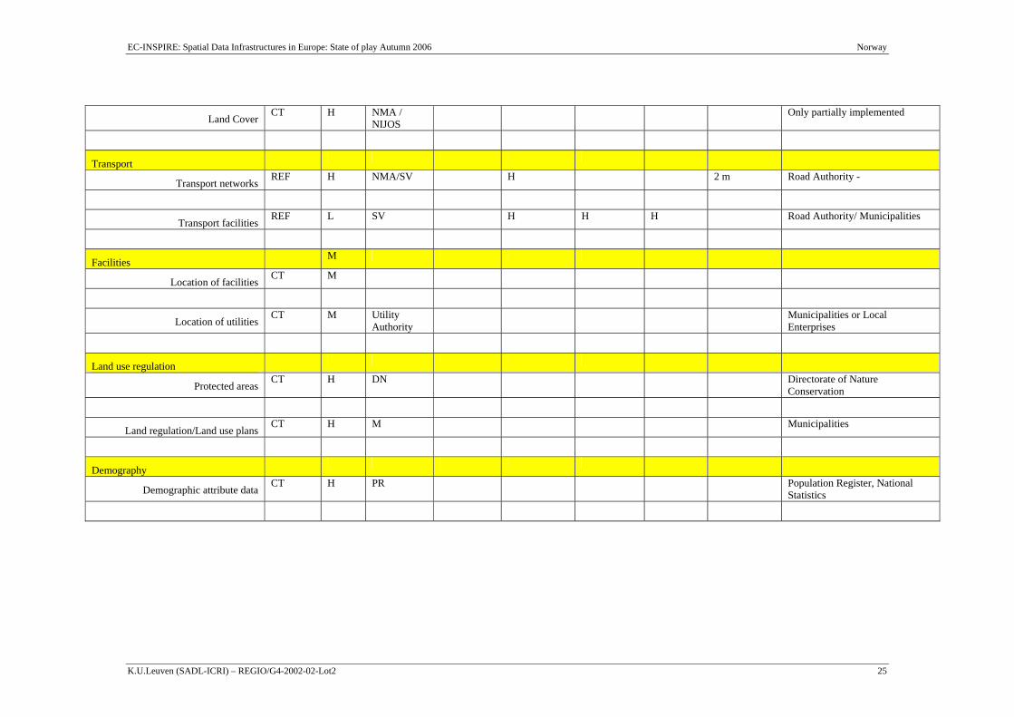
EC-INSPIRE: Spatial Data Infrastructures in Europe: State of play Autumn 2006 Norway
K.U.Leuven (SADL-ICRI) – REGIO/G4-2002-02-Lot2 25
Land Cover CT H NMA /
NIJOS Only partially implemented
Transport
Transport networks REF H NMA/SV H 2 m Road Authority -
Transport facilities REF L SV H H H Road Authority/ Municipalities
Facilities M
Location of facilities CT M
Location of utilities CT M Utility
Authority Municipalities or Local
Enterprises
Land use regulation
Protected areas CT H DN Directorate of Nature
Conservation
Land regulation/Land use plans CT H M Municipalities
Demography
Demographic attribute data CT H PR Population Register, National
Statistics

EC-INSPIRE: Spatial Data Infrastructures in Europe: State of play Autumn 2006 Norway
K.U.Leuven (SADL-ICRI) – REGIO/G4-2002-02-Lot2 26
2.4.3 Geodetic reference systems and projections The co-ordinate system is UTM (EUREF89) with three zones (32, 33, 35).
EUREF 89 is the datum used in most mapping. The EUREF89 is based on the ellipsoid GR80 and this is nearly the same as WGS84.
Until 1993 either NGO1948 or ED50 were used as the official geodetic datum in Norway. The decision to change was based on the NMA working group RINGG (Reference group for Implementing of New Geodetic Reference) which prepared the strategy document for geodetic referencing in Norway.
The projection generally used for display and mapping is the Universal Transversal Mercator projection. This also applies to the geo-coded grid data as used by Statistics Norway.
To support converting co-ordinates there is a transformation library available and this assists in the storing and providing of transformation programmes such as WSK TRANS, FYKOD, VG-Trans, etc.
2.4.4 Quality of the data Overall the NSDI is being based on users’ needs analysis. Both Geovekst and AREALIS are examples of GI and SDI elements built from this user driven approach.
Updating of much of the data is continuous in nature, for example the Geovekst data are continuously updated for properties, addresses, buildings, roads, railways and other data related to construction.
In Geovekst there are standard contracts, technical manuals and guidelines. The program has developed standard bidding procedures and standard contracts describing both legal and technical matters. These documents are available on Internet, which means that all parties have access to the latest versions. In addition newsletters from the Geovekst Forum are distributed regularly.
Key documentation developed and made available under the Geovekst program are;
General agreement
Guidelines for national and local co-operation
Standard contracts
Standard for regional geodata production and maintenance
Standard model for cost sharing

EC-INSPIRE: Spatial Data Infrastructures in Europe: State of play Autumn 2006 Norway
K.U.Leuven (SADL-ICRI) – REGIO/G4-2002-02-Lot2 27
Manual for production of data in standardised form, including collection, structure, storage and exchange
Software for data production
Control procedures, including software, for checking data quality according to fixed specifications including content, accuracy, completeness and data homogeneity, data structure and data delivery
Developing of standard software for data production and quality control is done in close collaboration with Geovekst, however these activities belong mainly outside the scope of Geovekst. Manuals to be used by contracted private companies are developed in close collaboration with the private sector.
The main objective for Geovekst is mapping in the scales 1:500 to 1:5 000. The digital data are however also used for deriving maps in smaller scales.
2.4.5 Interoperability Various GIS software products are used throughout the different organisations and offices involved in GI/GIS projects as well as the NSDI. Examples include:
ArcGIS
ArcView
GIS/Line
VG-Systemene
Gemini-systemene
PS/WinMap
MapInfo
Fysak
SOSI-VIS (Browser of SOSI files free of charge)
[NMA] Data are mostly distributed according to the SOSI standards. Most software dealers in Norway have developed converter between SOSI and their software. There is an ongoing approach towards ISO/OGC standards6 to secure interoperability of data and products.
6 ISO standards employed are 19115, 19109, 19118, 19119 for Metadata, Schema and encoding and definition of services, and the OpenGIS specifications governing WMS, WFS, GML and Catalog and registry services.

EC-INSPIRE: Spatial Data Infrastructures in Europe: State of play Autumn 2006 Norway
K.U.Leuven (SADL-ICRI) – REGIO/G4-2002-02-Lot2 28
Establishing of digital data follows a nation wide standard for content, structure and exchange called SOSI. This common standard is necessary to make it possible to combine data established in different areas. Particularly the parties with data needs across community borders require that data are in accordance with standard. The standard operates with different classes relevant to the different levels of mapping. Which class to apply for the individual project, is negotiated by the parties to project. SOSI will be further developed according to ISO/CEN standards.
2.4.6 Language and culture Metadata and distributed data are available on platforms and systems that support multilingual and multicultural aspects. Most descriptions and accompanying documents are only available in Norwegian. Some new products and services are available in the two variants of Norwegian (Bokmal and Nynorsk), Sami and English.
2.4.7 Data Content No information has been found nor provided.
2.4.8 Geographical names In Norway the situation regarding place names is somewhat complicated. Different spellings of a name may be in official use at the same time, and the goal of establishing a single standardised form for each name is still a long way off.
The names are decided according to the Place Names Act of 1990. The main provisions are the following:
The public body which uses a place name should authorise the spelling;
Place names which have been determined by law should be used by the other public bodies;
Written form should be based on the traditional, local pronunciation, while keeping the current spelling rules.
All names recognised by Law must be reported to a central computerised register administered by the NMA. There could be several names on the same object. There is a code in the register for the status of the various names used.
The names in the NSDI are prepared based on the document “Toponymic guidelines for cartography – Norway”.
There are two official forms of written Norwegian, Bokmal (used by 85% of the population) and Nynorsk (used by 15% of the population). In the municipalities, 36% are using Bokmal as the official language, 28% have Nynorsk as the official language, while the remaining 36% of municipalities have made no final decision regarding official language.

EC-INSPIRE: Spatial Data Infrastructures in Europe: State of play Autumn 2006 Norway
K.U.Leuven (SADL-ICRI) – REGIO/G4-2002-02-Lot2 29
Other names will come from Sami, which is also an officially used language in the local administrations, and Kven (Finnish) place names are used in two Norwegian counties (Troms and Finnmark).
2.4.9 Character sets [NMA] Hydrographic presentation use the international standards specified in S 57.
For Topographic and thematic land mapping there is developed symbol fonts for carthographic presentations. There is some initiatives to compare the national symbols to international standards.
ISO 8859 –1 cover Norwegian language and ISO 8859-10 gives adaptation for Sami language.
ISO 10646 UNICODE is used for new web versions of information products like Norgesglasset.
Requirements for support of Sami languages in data processing.
The ministers and the president of the Sami Parliament in Finland, Norway and Sweden agree that the document adopted by the Sami Parliamentary Council entitled "Requirements for support of Sami languages in IT" constitutes a basic document where the issue of support for Sami languages in data processing is concerned. National standardisation projects in this area should be conducted in consultation with the Sami Parliaments.
2.5 Component 4: Metadata
2.5.1 Availability [NMA] Metadata are produced and managed for a very significant part of the mentioned reference and core thematic data.
The Norwegian standard SOSI requires some metadata elements, like geographic extent, coordinate reference system, quality (positional accuracy and lineage), owner, etc. This kind of metadata is available for most data in the Norwegian Infrastructure. However, there is a considerable effort going on to complement these with metadata elements required for a catalogue services according to IS 19115.
2.5.2 Metadata catalogues availability + standard NGIS (www.statkart.no/ngis) is normally referred to as the National Geographic InfraStructure. In fact it is the technological tool for data management and the

EC-INSPIRE: Spatial Data Infrastructures in Europe: State of play Autumn 2006 Norway
K.U.Leuven (SADL-ICRI) – REGIO/G4-2002-02-Lot2 30
distribution of GI of the Norwegian Mapping Authority. One of its key elements is a metadata catalogue. By mid 2004, the catalogue was not accessible while the new ISO19115-compliant catalogue was still announced (on 10-july-2000) for 2002. The overall web pages are out of date.
2.5.3 Dublin core metadata standards for GI-discovery Currently not applicable.
2.5.4 Metadata implementation SOSI provides the standardised format and Norwegian feature catalogue, metadata and data exchange, and it is widely used.
[NMA] The Norwegian metadata standard is a profile of ISO 19115, now being updated to reflect IS 19115, is just finalised (2003). The Norwegian metadata standard is just a translation of parts of the international standard, not a subset of metadata elements, and is 100% conformant to IS 19115.
Update procedures will depend on the dataset being considered. Some such as land cover are not frequently updated while others such as property are continuously updated.
2.6 Component 5: Network Services The main geoportal in Norway is at http://www.geonorge.no/ which is maintained by the national mapping agency. The data is documented based on the national standard SOSI. The databases and information are presented to the visitor via searchable maps and a clearinghouse for metadata. There are a number of new initiatives underway to implement the ISO 19100 family of standards (GINIE, Ostensen).
Standards used throughout Norway come from the SOSI, and are implemented 100% by both public and private users. There is virtually no proprietary data in Norway. ISO standards are planned to eventually replace the SOSI, beginning with metadata and other data documents and access. OGC specifications are selected for specific geo-spatial services (WFS, WMS).
The catalogue service Geodatakatalogen for Norge is now in its second version and is fully compliant with ISO 19115 Metadata standard. The catalogue is fully searchable and can be developed to be a node in a clearing house concept. On-line access will be secured at three levels using OGC specifications (GINIE):
WebMapServer (WMS ISO19128) serving map layers in image format;
WebFeatureService (WFS) serves geospatial objects in GML/XML formats;

EC-INSPIRE: Spatial Data Infrastructures in Europe: State of play Autumn 2006 Norway
K.U.Leuven (SADL-ICRI) – REGIO/G4-2002-02-Lot2 31
NGIS api is a functional interface for distributed cross-organisational data management based on ISO 19109, 19107, 19108, etc.
Via Internet connections the public user has access to a “user specific database”. Information and data may include the users own data and also data on the economy, demography, geodata, addresses, etc. The data can be processed and maps created. The user receives the maps via electronic distribution.
Most on-line access is available in Norwegian only. Translations into English are available in some places.
Following services are available: WS Address, WS property, WS building and property, WS municipality, WS place names and WS coordinate transformations.
2.6.1 On-line access service for metadata: discovery services See 2.5
2.6.2 On-line access service for data: download services See 2.5
2.6.3 Inter-linkages of on-line access services for metadata data See 2.5
2.6.4 OpenSource software [NMA] Norway is supporting the concept of model based approach (MDA) for geographic information, and is participating in projects like ACE-GIS (Adaptable and Composable E-commerce and Geographic Information Services).
The goal of the MDA is to provide the basic concepts for doing platform-independent architecture modelling and provide the means for transforming these models to platform-specific models or implementation code. The MDA will have impact on how we think about different model abstraction levels. It will also influence the tool support for the model-driven way of thinking.
More information is available on http://www.modelbased.net/umt, where software based upon the OpenSource is available for downloading.

EC-INSPIRE: Spatial Data Infrastructures in Europe: State of play Autumn 2006 Norway
K.U.Leuven (SADL-ICRI) – REGIO/G4-2002-02-Lot2 32
2.6.5 Availability of viewing services 2.6.5.1 Geographic Information in eNorge/eNorway
One programme that has supported the development of geographic information via the Internet, is eNorway7. The eNorway action plan explicitly addressed geographic information in a limited number of action points, all of which were tasked to the Ministry of Environment8:
Increase of access to local information through binding co-operation agreements with local authorities. Includes collaboration being established between local authorities, the government and other users of geodata on a common map database;
Establishment of a first version of Net portal for national geographic data;
Development of Net-based learning in the field of Geographic Information Technology (GIT). (Some E-learning already implemented on the standards-section (SOSI));
Implement pilot project for co-ordinated administration of geographic information.
Public sector information and services on the Internet (http://english.norge.no/) are provided as part of the overall e-Government service established by the Government of Norway in order to provide easy access to public sector information and services on the web supplied by public bodies at state, county and municipal level.
The Internet service www.norge.no presents, for example, each commune and county with an assessment and a graded evaluation of the availability of PSI, contact information, web pages and interactive Web mapping.
7 This is the e-government initiative as described in the document “eNorway Action Plan 2.0” (http://odin.dep.no/nhd/norsk/enorge/p10001876/024101-220008/index-dok000-b-n-a.html) 8 All tasks were planned for completion in 2001.

EC-INSPIRE: Spatial Data Infrastructures in Europe: State of play Autumn 2006 Norway
K.U.Leuven (SADL-ICRI) – REGIO/G4-2002-02-Lot2 33
Overview map (example for Oslo):
Detailed map (example for Oslo):
The portal GeoNORGE is a nation wide gateway for geographic information. The gateway is established and run by GeoForum and Statens Kartverk (Norwegian Mapping Authority) together. Here interested institutions and individuals can apply to get and give

EC-INSPIRE: Spatial Data Infrastructures in Europe: State of play Autumn 2006 Norway
K.U.Leuven (SADL-ICRI) – REGIO/G4-2002-02-Lot2 34
updated information on geomatics. The gateway is a shortcut to information about official institutions and private companies and their products and services.
Other interactive Web mapping applications by the NMA: Norgesglasset and Visveg.
2.6.6 Availability of catalogue services to regulate access No information has been found.
2.6.7 Availability of catalogue services that perform payment operations No information has been found.
2.6.8 Availability of catalogue services to extract and send data to a user application
No information has been found.
2.6.9 SDI user applications No information has been found.
2.6.10 Availability of geo-processing services No information has been found.
EC-INSPIRE: Spatial Data Infrastructures in Europe: State of play Autumn 2006 Norway
K.U.Leuven (SADL-ICRI) – REGIO/G4-2002-02-Lot2 35
2.7 Standards [NMA] The Ministry of the Environment has given NMA the responsibility for standards and guidelines within Geomatics (mapping, surveying, positioning and Geographic Information). Since 1990 NMA has accomplished a comprehensive program to establish a series of national branch standards. NMA has as a strategy to go in for international standardization and take international standards into use when they are available.
The standards series are released (yearly the last four years) at a CD-ROM, "Standarder Geografisk informasjon". The standards cover a wide range of topics:
Avtale for geodataarbeider (Contract for Geodata works)
Fastmerkenummerering og fastmerkeregister (Numbering and register for Survey control stations)
Grafisk utforming av kart i M 1:500 – 1:20000 (Graphical symbols/ Map symbols at Maps in the scales 1:500 – 1:20000)
Grunnlagsnett (Fundamental Networks)
Integrasjon av sak/gis/gab-systemer i lokal forvaltning (Geolok) (Integration of systems in Local administration)
Kontroll av geodata (Control of geodata)
Kontroll og kalibrering av elektrooptiske avstandsmålere (Control and calibration of Electro-optical distance meters)
Koordinatbasert referansesystem (Coordinate-based Reference systems)
Kvalitetssikring av oppmåling, kartverk og geodata ("Geodatastandarden") (Quality Assurance of Surveying, mapping and geodata)
Ledningskart (Facility Maps)
Norges offisielle høydesystem og referansenivåer (Norways official Vertical control system and Vertical datum)
Ordbok for kart og oppmåling (Dictionary for Mapping and surveying)
Plassering og beliggenhetskontroll (Control of Position and "As built")
Satellittbasert posisjonsbestemmelse (Satellite-based positioning)
SOSI Et standardformat for digitale geodata (SOSI A Standard Format for Digital geodata)
EC-INSPIRE: Spatial Data Infrastructures in Europe: State of play Autumn 2006 Norway
K.U.Leuven (SADL-ICRI) – REGIO/G4-2002-02-Lot2 36
Stedfesting av eiendoms- og råderettsgrenser (Positional Referencing of Property- and Easement Boundaries)
Stedfesting av natur- og samfunnsgeografisk informasjon (Positional referencing of Information about nature and society)
Symboler og forkortelser i norske sjøkart (Symbols and abbreviations used on Norwegian Charts)
Symbolfonter for friluftsliv og sport (Symbol fonts for outdoor life and sports)
VA-ledningskartverk (Facility maps, Water and Sewerage)
The Norwegians claims that no format in the world is so well known and widely used within a country as SOSI is in Norway. Hence, data are mostly distributed according to the SOSI standards. Most software dealers in Norway have developed converter between SOSI and their software.
As a spin-off of the heavy engagement in standards works Norway is at the head of the international standards work carried out by ISO. Norway has the chair and secretariat of ISO /TC 211 Geographic Information/ Geomatics, has one of four chairs of the working groups, and 5 of 21 project team leaders engaged by the TC.
Together with the standards comes supporting software for quality assurance and visualisation of data in the SOSI format, and TrueType fonts with symbols. Terminology is taken care of by the database "Termer for geografisk informasjon" (http://decentius.hit.uib.no/kartverket/search.html (Username:gjest, password:gjest)
The CD "Standarder Geografisk informasjon" also contains guidelines from the Ministry of the Environment:
Digitale planer etter plan- og bygningsloven (Digital plans according to the law of Planning and building
Kartgrunnlag for plan-og byggesaksbehandlingen (Maps for the handling of Planning and building cases)
Kommunplanens arealdel (The area part of the Municipality plans)
Reguleringsplan. Bebyggelsesplan. (Regulation and settlement plans)
Further information can be obtained at http://www.statkart.no under "Standardisering" (Norwegian only).
There is a clearly expressed strategy within the national geographic infrastructure to converge the national standards to be conformant to international standards. The Norwegian metadata standard (part of SOSI) is just a translation of parts of the international standard, not a subset of metadata elements, and will in short time be 100%

EC-INSPIRE: Spatial Data Infrastructures in Europe: State of play Autumn 2006 Norway
K.U.Leuven (SADL-ICRI) – REGIO/G4-2002-02-Lot2 37
conformant to the just published ISO 19115. There is a general ongoing approach towards ISO/OGC standards9 to secure interoperability of data and products.
Other standards in the process of being employed is (some of these are not yet finalized)
ISO 19101 - Reference model
ISO/TS 19103 - Conceptual schema language
ISO 19104 - Terminology
ISO 19106 - Profiles
ISO 19107 - Spatial schema
ISO 19108 - Temporal schema
ISO 19109 - Rules for application schema
ISO 19110 - Feature cataloguing methodology
ISO 19111 - Spatial referencing by coordinates
ISO 19113 - Quality principles
ISO 19114 - Quality evaluation procedures
ISO 19115 - Metadata
ISO 19118 - Encoding
ISO 19119 - Services
ISO 19127 - Geodetic codes and parameters
ISO 19128 / OGC-WMS - Web Map Server Interface and gridded data
ISO 19131 - Data product specification
The Norwegian Feature Catalogue (SOSI part 2) covers 44 application domains;
Survey Control Stations
Terrain
9 ISO standards employed are 19115, 19109, 19118, 19119 for Metadata, Schema and encoding and definition of services, and the OpenGIS specifications governing WMS, WFS, GML and Catalog and registry services.

EC-INSPIRE: Spatial Data Infrastructures in Europe: State of play Autumn 2006 Norway
K.U.Leuven (SADL-ICRI) – REGIO/G4-2002-02-Lot2 38
Coast and sea (S57)
Inland sea, rivers
Fishery
Oil
Land property
Land restrictions / easements
Administrativ and statistic areas
Land types
Agricultural Property Register
Land inventory
Soil-data
Introduction - geology
Mineral resources
Bedrock geology
Surficial deposits
Geochemical mapping
Geophysical mapping
Geological conservation areas
Cave mapping (speleologi)
Reindeer management
Natural resources, wildlife, etc
Other land use
Buldings
Other building constructions
Archaeological and architectural monuments and sites and cultural environments
EC-INSPIRE: Spatial Data Infrastructures in Europe: State of play Autumn 2006 Norway
K.U.Leuven (SADL-ICRI) – REGIO/G4-2002-02-Lot2 39
Road data
Road situation
Railway
General transport
Adresses
Airport
Utility
Location names
Planning
Projecting
Forestry
Grazing land
Landscape
Preservation of natural resources
Biological diversity
Land Consolidation Planning
Landslide
There is work ongoing to model these application domains in UML according to ISO 191xx standards. As a fundament for this work, a document has been established, called "Modeling in UML - Static structure diagram". This document embeds the principles of ISO/TS 19103 - Conceptual schema language and ISO 19109 - Rules for application schema, also including practical examples from the GI field and finally guidelines for how to enable exporting models by XMI. All information (in Norwegian language only) about SOSI is available at http://www.statkart.no/standard/sosi/html/welcome.htm.
S-44 IHO Standards for Hydrographic Surveys
States the standards recommended for the scale of survey and the density of soundings; accuracy of horizontal position; accuracy of depth and other measurements. This includes classification criteria for deep-sea soundings and procedures for eliminating doubtful data.
S-52 Specifications for Chart Content and Display Aspects of ECDIS
EC-INSPIRE: Spatial Data Infrastructures in Europe: State of play Autumn 2006 Norway
K.U.Leuven (SADL-ICRI) – REGIO/G4-2002-02-Lot2 40
Prepared by the IHO Committee on Hydrographic Requirements for Information Systems (CHRIS), provides specifications and guidance regarding the issuing of Electronic Navigational Charts (ENC), their display in an Electronic Chart Display and Information System (ECDIS) and their updating. S-52 was developed in conjunction with the IMO Performance Standards for ECDIS.
S-57 IHO Transfer Standard for Digital Hydrographic Data
Standard prepared by the IHO Committee on Hydrographic Requirements for Information Systems (CHRIS), for the coding and exchange of hydrographic digital data, including that intended for ECDIS purposes.
S-58 IHO Recommended ENC Validation Checks
Specifies the minimal checks that producers of ENC validation tools should include in their validation software.
S-63 IHO Data Protection Scheme
Describes the IHO ENC security scheme, as well as test data and a software kernel. It is intended for use by all those ECDIS manufacturers and data distributors participating in an ENC service with data encrypted.
2.8 Component 6: Thematic environmental data With respect to the environmental thematic data component of the NSDI, AREALIS is important. AREALIS is coordinated by the NMA as well which makes it close to the environmental side of the NSDI.
AREALIS aims to structure the collaboration amongst the players and to facilitate the flow of data and information. AREALIS includes land cover data, environmental data, planning information, and other data.
The aim of the AREALIS is to achieve better area and resource planning by bringing together the environmental/natural resource data, basic geographic information, property data, positioning data and existing area plans and environmental preservation measures.
2.8.1 Application of the legal framework and funding principles (for reference & core thematic data) to thematic environmental data
The AREALIS programme was originally a pilot project funded by the Ministry of Environment with contributions from other national Ministries and regional and local planning bodies. Regarding how the funding continues now that the project has moved into a long-term operational component of the NSDI, the following can be noted:
Most environmental data will be free of charge except distribution costs;
Reference data will be subject to ordinary costs;
EC-INSPIRE: Spatial Data Infrastructures in Europe: State of play Autumn 2006 Norway
K.U.Leuven (SADL-ICRI) – REGIO/G4-2002-02-Lot2 41
Formal agreements will be used to co-ordinate data sharing.
2.8.2 Application of reference data & core thematic data characteristics to thematic environmental data
The Norwegian standards (SOSI) are being applied for the definitions of features and attributes in the AREALIS.
The thematic information in AREALIS includes more than 150 datasets organised into 12 main topics or themes. The themes are based on local and regional users needs.
Nature – including geology, biodiversity, conservation of nature, hydrology
Agriculture and forestry – including suitability for crops, soil erosion susceptibility, etc.
Cultural heritage – including landscapes, archaeological sites, historical buildings, etc.
Recreation – such as important areas and tracks
Landscape classification
Polluted sites and sources of pollution
Coastal aspects and fisheries
Land use plans and other planning elements
Public safety issues – including crucial issues for built-up areas and other human activities, presenting areas prone to landslides, etc.
Water supply – ground water quality and availability issues
Demography
General topographic map data
2.8.3 Application of metadata issues to thematic environmental data The feature catalogue will be ISO compliant. The ISO/TC 211 Feature Catalogue methodology will be applied.
The Catalogue of Data Sources (CDS) tools (WinCDS 2001, data cataloguing system as made available from the European Environment Agency) are also used within the Norwegian context. The CDS tools make use of the GEMET (General multi-lingual Environmental Thesaurus, version 2001), which has a core terminology consisting of more than 5.400 terms and definitions. It is available in 19 languages including

EC-INSPIRE: Spatial Data Infrastructures in Europe: State of play Autumn 2006 Norway
K.U.Leuven (SADL-ICRI) – REGIO/G4-2002-02-Lot2 42
Norwegian and all other Nordic languages (exception is Icelandic). GEMET 2001 is made available in different formats.
2.8.4 Application of access services issues to thematic environmental data AREALIS is in effect the environmental branch of the NSDI, and is available over the Internet.
The Norwegian Water and Energy Resources Directorate developed several atlases for viewing water and energy resources data together with reference data through the web (http://arcus.nve.no/nyatlas).
2.8.5 Application of standards issues to thematic environmental data The SOSI standards used for the NSDI are also applied within AEALIS.
2.8.6 Application of update procedures issues to thematic environmental data
No information has been found about the update procedures of thematic environmental data.
2.9 Use and efficiency of SDI In a recent report on the state of the NSDI (Lillethun, 2002), one issue of importance is that local level needs are not being met regarding availability of information, services and procedures.
This is important as there has been a recent shift towards more local management with greater responsibilities in sustainable land use and environmental soundness. This shift has increased the need for local information about national interests, regulations, etc. It is known that useful information exists but very often remains inaccessible – digital information is residing in internal databases and analogue information is stored away in files and drawers, etc.
Also access to information has so far proved difficult to achieve as the players (mainly the public bodies) are diverse and include: municipalities, counties, regional authorities for environment and fishing, the NMA, state county representatives and both national data suppliers and users.
Regarding the impact of the NSDI onto the business sector estimates have been presented for the benefit to business by the use of standards amounting to a total of about

EC-INSPIRE: Spatial Data Infrastructures in Europe: State of play Autumn 2006 Norway
K.U.Leuven (SADL-ICRI) – REGIO/G4-2002-02-Lot2 43
2 200 million NOK10 (just under 268 million EURO). The benefits realised are due to increased efficiency, better security and better service (Strande).
A number of critical factors and observations have been made regarding the NSDI situation in Norway. These are a set of problem issues facing Norway and provide a critical review of what needs to be addressed in order to ensure a greater NSDI success (Strande):
For the general situation, if an infrastructure does not develop at the speed of the users and the technological changes;
For data capture which is based on administrative routines, if reporting is not functioning or quality checked;
If Quality secure work is not very good, if data is not reliable;
If data is too hard for users to access, if it is not convenient enough;
If integration between the different datasets is poor or not sufficient;
If data does not match the demands from each user;
If data production is not efficient and the costs remain too high;
For data users – if they feel the price of data is too high.
One driving force for the NSDI in Norway, as in a number of other countries, are the eGovernment and eEurope programmes which serve to play an active role for encouraging Internet access to information and services, and for promoting the development of strategy documents from the central and/or regional levels. The eNorge initiative is one such example (Ostensen).
The development of the NSDI in Norway has been in accordance with existing IT strategies. The NSDI makes specific reference to the IT Policy of the Association of Municipalities, which states that municipalities and counties ought to take part in the development of national geographic information systems that can contribute to increased value for society. The establishment of such information systems must be based on agreements between municipalities and the national government where there are equal partners and equal rights to use the data (Strande).
10 Figures are probably relevant for the year 1999 or 2000.

EC-INSPIRE: Spatial Data Infrastructures in Europe: State of play Autumn 2006 Norway
K.U.Leuven (SADL-ICRI) – REGIO/G4-2002-02-Lot2 44
3 Annexes
3.1 List of SDI addresses / contacts for Norway Table: SDI contact list Web address Organisational
mailing address Over-all contact person: tel./fax/e-mail
National Norwegian Mapping Authority / Statens kartverk
www.statkart.no Statens kartverk Service box 15 N-3504 Honefoss Norway
Kari Strande International Director Statens kartverk Tel.: +47 32 11 81 37 Fax: +47 32 11 81 01 (& 84 61) [email protected]
GeoForum www.geoforum.no GeoForum Storgt. 11 N-3510 Hønefoss Norway
Tel.: +47 32 12 31 66 Fax: +47 32 12 06 16 E-mail: [email protected]
Statens kartverk Service box 15 N-3504 Honefoss Norway
John Naustdal, Director Land division [email protected] Tel.: +47 32 11 81 56
Statens kartverk Service box 15 N-3504 Honefoss, Norway
Erik Perstuen, Deputy director Land division [email protected] Tel +47 32 11 84 49
Statens kartverk Oslo og Akershus Storgt 33 Postboks 8120 Dep N-0032 Oslo, Norway
Einar Jensen, Technical director Geovekst [email protected] Tel +47 22 99 10 20
Statens kartverk Service box 15 N-3504 Honefoss, Norway
Nils Flakstad Technical director maps and map data [email protected] +47 32 11 82 58
Statens kartverk Hedmark Vangsv 73 N-2326 Hamar,
Kåre Kyrkjeeide, Technical director environment (AREALIS) kaare.kyrkjeeide@statkart.

EC-INSPIRE: Spatial Data Infrastructures in Europe: State of play Autumn 2006 Norway
K.U.Leuven (SADL-ICRI) – REGIO/G4-2002-02-Lot2 45
Norway no Tel +47 62 53 66 22
Statens kartverk Service box 15 N-3504 Honefoss, Norway
Karsten Lien, Technical director [email protected] +47 32 11 83 57
Statens kartverk Service box 15 N-3504 Honefoss, Norway
Tone Irene Kristiansen Technical director technology management [email protected] Tel +47 32 11 83 50
3.2 List of references for Norway Table: list of references used to compile the Country Report
Web sites:
NMA / Statens kartverk http://www.statkart.no
Ministry of the Environment http://odin.dep.no/md/engelsk/index-b-n-a.html
GeoNorge (part of the NSDI) http://www.geonorge.no/IPS/geonorge.no/
AREALIS (part of the NSDI) http://www.statkart.no/AREALIS/hvaerAREALIS/AREALISenglish.html
ACE-GIS project description http://www.ec-gis.org:8080/wecgis/ECGIS.DYN_PROJECT.show?nome='369'
Homepage for the ACE-GIS project
http://www.acegis.net/
National Road database (interactive Web Map available for free use) “Visveg”
http://www.visveg.no/norguide/
NORGESGLASSET (interactive Web Map available for free use)
http://ngis2.statkart.no/norgesglasset/default.html
Rescue and Emergency Operations
http://www.statkart.no/cerco
Directorate for Nature Management (DN)
http://english.dirnat.no/
Geovekst http://www.statkart.no/geovekst

EC-INSPIRE: Spatial Data Infrastructures in Europe: State of play Autumn 2006 Norway
K.U.Leuven (SADL-ICRI) – REGIO/G4-2002-02-Lot2 46
GeoForum – organization for GI http://www.geoforum.no
Geodata http://www.geodata.no/
eNorway Action Plan 2.0 and 3.0
http://www.dep.no/nhd/english/doc/plans/bn.html
Public sector information and services on the Internet
http://english.norge.no/
Geologic Survey of Norway (NGU)
http://www.ngu.no/
Research and Innovation Web Site: Oslo
http://www.cordis.lu/oslo/home.html
The Norwegian Social Science Data Services (NSD)
http://www.nsd.uib.no/english/
Ministry of Transport and Communication
http://odin.dep.no/sd/engelsk/index-b-n-a.html
Norwegian Geotechnical Institute
http://www.ngi.no/
Research Council of Norway http://www.forskningsradet.no/english/
Norwegian Water and Energy Resources Directorate
http://www.nve.no/
Marine geology and resources http://www.mareano.no
Publications:
Craglia, M. (2000). Geographic Information Policies in Europe: Naional and Regional Perspectives – Report of the EUROGI-EC Data Policy Workshop, Amersfoort, 15 November 1999.
Clark, Mike (2002). Briefing notes to the INSPIRE DPLI Working Group, Appendix A – EU Member States (brief1.doc).
Geovesk forum (2002a). “Overgang til EUREF89 - trinn for trinn” (Users guide for EUREF89 – step by step). Text is in Norwegian, and was prepared by Lillan Jensen..
Geovesk forum (2002b) “Retningslinjer for innføring av EUREF89” Text is in Norwegian, and was prepared by Lillan Jordbru.
GINIE: Geographic Information Network in Europe. Spatial data infrastructures: Country Reports FINAL D 5.3.2(b). September 2002.
Helleland, Botov (2000). “Toponymic guidelines for cartography – Norway”

EC-INSPIRE: Spatial Data Infrastructures in Europe: State of play Autumn 2006 Norway
K.U.Leuven (SADL-ICRI) – REGIO/G4-2002-02-Lot2 47
Lillethun, Arvid (2002). “AREALIS the Norwegian Environmental NSDI”, presented at the 6th GSDI meeting in Budapest, Hungary, 16-19 September 2002.
Masser, Ian (1999) “All shapes and sizes: the first generation of national spatialdata infrastructures”, International Journal of Geographic Information Science, vol. 13(1), pp. 67-84
Onsrud, H., Department of Spatial Information Science and Engineering, University of Maine, Orono, Maine. GSDI - Survey of National and Regional Spatial Data Infrastructure Activities Around the Globe, Part I – National Spatial Data Infrastructure Initiatives. http://www.spatial.maine.edu/~onsrud/GSDI.htm
Ostensen, Olaf (2002). NSDI: Norway. Presentation linked to the GINIE project. Rogstad, Lars (2001). “GIS Projects in Statistics Norway 2000/2001”, publication
number 2001/16, published by Statistics Norway Division for Information Technologies.
Statistics Finland, Statistics Sweden, and Statistics Norway (2000). UN/ECE Work Session on Methodological Issues Involving the Integration of Statistics and Geography (10-12 April 2000). Working Paper No. 24, “GRID data and area delimitation by definition – towards a better European territorial statistical system”
Strande, Kari (2000). “Norway Digital” – a core fundament for value adding. A White paper about a public infrastructure for geographic information.
When de Montalvo, Uta (2001). “Strategies for SDI implementation: A survey of national experiences. Paper presented at the 5th Global Spatial Data Infrastructure Conference, 21-25 May 2001
GINIE - GI in the Wider Europe Complete Book, October 2003
http://wwwlmu.jrc.it/ginie/doc/ginie_book.pdf