Spatial analysis and spatiotemporal modelling methods · PDF fileGeoinformation and Earth...
10
Spatial analysis and spatiotemporal modelling methods Geoinformation and Earth Observation for environment and territories 16 © Cemagref S Unfragmented terrestrial natural areas in France classified according to size (50 km² and over) in 2000.
Transcript of Spatial analysis and spatiotemporal modelling methods · PDF fileGeoinformation and Earth...

Spatial analysis and spatiotemporal modelling methods
Geo
info
rmat
ion
an
d E
arth
Ob
serv
atio
n fo
r en
viro
nm
ent a
nd
terr
itor
ies
16
© C
emag
ref
Unfragmented terrestrial natural areas in France classified according to size (50 km² and over) in 2000.
Cabantous
Zone de texte
From Agropolis International thematic directory n° 9 - "Geoinformation and Earth Observation for environment and territories" (February 2010 - 68 p.)

Geo
info
rmat
ion
an
d E
arth
Ob
serv
atio
n fo
r en
viro
nm
ent a
nd
terr
itor
ies
17
patial analysis and spatiotemporal modelling are geared towards formalizing the spatial characteristics and spatiotemporal dynamics of
systems (ecosystems, agricultural systems, territories, etc.) on the basis of often incomplete and imprecise data and more-or-less indepth knowledge on the underlying processes. Once mapped and modelled in this way, researchers can gain insight into these systems to enhance their management.
It is essential to determine the spatial dimension of systems and take the presence of several partially interlinked levels of internal organization into account in order to understand their functioning. This may include environmental and socioeconomic dynamics and their interactions within territories. Spatial analysis and modelling are thus guided by both the space and the investigated issues, for which some structures and processes may turn out to be more relevant than others. The space is thus a ‘support’ and a ‘revealer’ of processes that have biophysical (disseminations, flows, ecological processes, etc.), technical (agricultural practices, management practices), human and social (stakeholders’ strategies, collective actions, exchanges, etc.) features.
Spatial analysis may be carried out to characterize the properties of different features (urban clusters, river systems, natural habitats, etc.) or ranges of variables (rainfall, population density, etc.). Each feature or range can be described by its position, footprint, morphology, topology, structure and internal variability. Spatial analysis is also aimed at determining the spatial organization of a group of features (e.g. individuals in a population) or the limits and interactions between different groups. Spatial analysis research encompasses a very broad range of methods adapted to different issues and types of system: sampling methods (in situ metrology, surveys, etc.), system description methods (geography, cognitive sciences, etc.), spatial and/or temporal field reconstruction methods (geostatistics, oversampling), environmental indicator construction, spatialization and mapping methods, and construction of spatial metrics and indicators.
Spatiotemporal modelling is aimed at drawing up representations of systems while taking their spatial and temporal dimensions into account.
There are two separate but complementary aspects to this modelling: first the structural aspects with the representation of spatial structures and associated information and indicators and, secondly, the dynamic aspect with the representation of temporal sequences of spatialized information and even of the underlying processes. The dynamics can be portrayed by a series of system states or by a continuous spatiotemporal formalization of the processes–via these simulations, hypotheses can be tested by taking the spatial dimension into account, and scenarios can also be studied. Spatiotemporal modelling research also involves a broad range of methods, including procedures for analysing correlations between spatial fields, pressure-state-response models, different spatiotemporal modelling approaches (deterministic to conceptual, distributed to aggregated, cellular automatons, agent based models, etc.), parametering of distributed models and analysis of uncertainty propagation in these models.
When a variety of stakeholders or topics have to be managed within the same territory, it is essential to consistently overlap the different spatial structures relevant to each of them, which may each present a different spatial and temporal aspect. Spatiotemporal modelling can thus contribute to the modelling of complex systems.
The research carried out by Agropolis teams showcased in this chapter illustrates the methodological spatial analysis research conducted on the basis of remote sensing data or cartographic data derived from surveys or local observations. Reconstructing spatial fields by spatial interpolation methods, and taking the data quality into account from both spatiotemporal and semantic standpoints, are major challenges for all teams. Spatiotemporal modelling studies are focused mainly on coupling different models integrating spatial descriptions, and on the assimilation of geographical or remote sensing data. The modelling types also differ, ranging from mechanistic models designed to gain insight into processes, to indicator-based models that provide decision support in management processes.
Flavie Cernesson (UMR TETIS)& Jean-Pierre Müller (UR GREEN)
S

Geo
info
rmat
ion
an
d E
arth
Ob
serv
atio
n fo
r en
viro
nm
ent a
nd
terr
itor
ies
18
Spatial analysis and spatiotemporalmodelling methods
distribution patterns, ecological descriptor maps, topologies of plants or habitat networks, and remote sensing images (optical, laser, radar). The methodological research is thus focused on geoinformation analysis and modelling via the application of mathematics or applied statistics (Markov chains, graph theory, point processes, geostatistics, wavelet and Fourier based image analysis, etc.) in botany or plant ecology studies. Remote sensing information is used in spatial analysis and modelling in three main thematic areas:
spatial organization of species communities and plant biodiversity
structure and dynamics of plant populations, especially mixed multistrata forests
plant and landscape mosaics.
These three research themes respectively emphasize the diversity of groups of species and emerging structural properties on population and population-mosaic scales.
Considerable methodological debate is currently under way on remote sensing measures (optical, radar, laser) with respect to the two latter research themes. The focus is on interfacing dynamic models of the 3D structure of forests and physical measures produced by spatial sensors. The aim is to develop innovative approaches for large-scale assessment and monitoring of mixed forest resources and biomass. •••
Geoinformation and modelling applied to botany and plant ecology
The joint research unit (UMR) Botany and Computational Plant Architecture (UMR AMAP, CIRAD, INRA, CNRS, IRD, UM2) conducts research on the characterization and analysis of diversity, and the organization and structure of plants and plant populations. Original methods are used such as the analysis of plant architecture and development, computer-assisted identification, mathematical and computer representation of organs, plants, populations and landscapes, and modelling of their growth and production. The UMR works in close collaboration with researchers specialized in various disciplines to assist in its cognitive (botany and ecology), methodological (applied mathematics) and targeted (agronomy, forestry, conservation) research projects. The team has substantial expertise in systematics and plant architecture, supported by several taxonomic platforms (herbarium collections based in Cayenne, Montpellier, Nouméa). It conducts field research in Europe, Africa, South America, Asia and Oceania.
Georeferenced or spatially explicit information is used in much of this research, e.g. plant organ distributions in 3D space, species
Main teamsUMR AMAP – Botany
and Computational Plant Architecture(CIRAD, INRA, CNRS, IRD, UM2)Director: Daniel Barthémély, [email protected]
http://amap.cirad.fr
UMR HydroSciences Montpellier(CNRS, IRD, UM1, UM2)
75 scientists, with 20 involved in the research topicDirector: Eric Servat,
UMR LISAH - Laboratoire d’étude des Interactions Sol - Agrosystème –
Hydrosystème(INRA, IRD, Montpellier SupAgro)
30 scientists, with 12 involved in the research topicDirector: Marc Voltz, [email protected]
www.umr-lisah.fr
UMR TETIS - Geoinformation and Earth Observation for Environment
and Land Management(see page 8)
UPR Dynamics of Natural Forests(see page 44)
UPR GREEN - Management of Renewable Resources and Environment
(CIRAD)14 scientists, with 5 involved in the research topic
Director: Martine Antona, [email protected]
www.cirad.fr/ur/green_en/page_d_accueil
US ESPACE - Expertise et SPatialisation des Connaissances en Environnement
(see page 8)
...continued on page 20

Geo
info
rmat
ion
an
d E
arth
Ob
serv
atio
n fo
r en
viro
nm
ent a
nd
terr
itor
iesVegetation structure relates to the layout of constituent plants
and organs in 3D space. This organization can be quantified on the basis of variables (density, tree height, biomass, profile, etc.) that are estimated by field procedures. Space observations are required for large-scale analysis of vegetation structures and for monitoring the underlying functional processes (exchanges with the atmosphere) or associated dynamics. This is a substantial challenge when attempting to assess forest stands with high biomass and a complex multistrata structure, such as natural forests in humid tropical regions. For such environments, the remote sensing techniques used over the last two decades have often been hampered by the problem of saturation of optical or radar signals from forests with intermediate to high biomass levels.
Recent studies based on metric resolution optical data have shown that the results of the analysis of spatial signal variations by texture and feature identification procedures (in partnership with EPI ARIANA of INRIA-Méditerranée) can be correlated
with the field-based findings on structure variables with no saturation effect. Moreover, 3D characterization of forest cover structures can be further enhanced by the use of signals that are able to penetrate through the cover (lidar, radar). Multiscale coupling of forest structure models with physical models that can simulate electromagnetic signal diffusion (from optical to microwave) is necessary for the ‘inversion’ of remote sensing data into relevant thematic information. Concerning tropical forests, this coupling is dependent on the capacity to build ecologically realistic models of 3D structures in forest stands in order to simulate their electromagnetic signatures. Through this modelling, the aim is, for instance, to formally relate texture indices to a distribution of structural features (tree crowns, gaps), or to relate signal penetration to the vertical vegetation stratification. In turn, forest dynamics models could be enhanced by gaining greater insight into electromagnetic signatures of tropical forests.
Contact: Pierre Couteron, [email protected]
Multiscale coupling of 3D models of forest/vegetation stands using space observation based methods
Principle of multiscale coupling of remote sensing data (Box A) and forest dynamics models generating 3D models of stand structure (Box B) for the characterization of tropical forest environments (Box C).
A. Top: IKONOS image extract.
Bottom: 3D reconstruction of a forest structure by point-cloud interpolation (‘voxels’).
B. Extracts of forest dynamics simulations from the CAPSIS/AMAP library.
C. Top: Photograph of a mixed tropical forest.
Bottom: Forest biomass chart produced by inversion of a model based on canopy textures.
© S
pace
Imag
ing
Ltd.
© UMR AMAP
© U
MR
AM
AP
© Remote Sensing of Environnement
19
Geo
info
rmat
ion
an
d E
arth
Ob
serv
atio
n fo
r en
viro
nm
ent a
nd
terr
itor
ies
20
mechanisms and impacts on water resources’, is devoted to climatic and/or human induced hydrological changes in tropical and semiarid regions. Spatiotemporal data analysis is necessary for characterizing and understanding the structures and dynamics that prevail, for instance, in Sahelian regions where the environmental balance is weakened by drought, desertification and ever-increasing human pressure. Moreover, these approaches are essential for monitoring the evolution of tropical glaciers, which is a major water resource issue.
The second research area, i.e. ‘Hydrological risks associated with extreme hazards’, introduces the concept of risk, irrespective of whether it is associated with extreme hydroclimatic events or concomitant pollution flows. Substantial spatiotemporal data must be available and managed to be able to gain insight into and monitor parameters as divergent as spatial variability in rainfall, territorial organization, plant cover modifications, types of land use and associated water level variations.
Through collaborations with many partners, HydroSciences Montpellier
Climatic and human impacts on water resources in Mediterranean and tropical environments
The joint research unit (UMR) HydroSciences Montpellier (CNRS, IRD, UM1, UM2) studies climatic and human impacts on water resources in Mediterranean and tropical environments. This research involves the analysis and modelling of underlying processes, the characterization of regional phenomena and the development of conceptual modelling approaches. The research activities of HydroSciences Montpellier encompass: (1) water in the environment, (2) water resources, and (3) links between hydroclimatic variability and water resources.
Two of the laboratory’s main research areas are concerned about addressing the ‘impact of climate change’ issue and implementing methods for the management, analysis and processing of spatiotemporal data through flow simulation models.
The first research area, i.e. ‘Hydrological variability: analysis,
Spatial analysis and spatiotemporal modelling methods
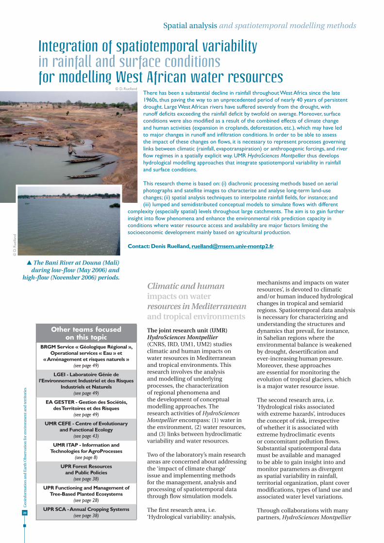
There has been a substantial decline in rainfall throughout West Africa since the late 1960s, thus paving the way to an unprecedented period of nearly 40 years of persistent drought. Large West African rivers have suffered severely from the drought, with runoff deficits exceeding the rainfall deficit by twofold on average. Moreover, surface conditions were also modified as a result of the combined effects of climate change and human activities (expansion in croplands, deforestation, etc.), which may have led to major changes in runoff and infiltration conditions. In order to be able to assess the impact of these changes on flows, it is necessary to represent processes governing links between climatic (rainfall, evapotranspiration) or anthropogenic forcings, and river flow regimes in a spatially explicit way. UMR HydroSciences Montpellier thus develops hydrological modelling approaches that integrate spatiotemporal variability in rainfall and surface conditions.
This research theme is based on: (i) diachronic processing methods based on aerial photographs and satellite images to characterize and analyse long-term land-use changes; (ii) spatial analysis techniques to interpolate rainfall fields, for instance; and (iii) lumped and semidistributed conceptual models to simulate flows with different
complexity (especially spatial) levels throughout large catchments. The aim is to gain further insight into flow phenomena and enhance the environmental risk prediction capacity in conditions where water resource access and availability are major factors limiting the socioeconomic development mainly based on agricultural production.
Contact: Denis Ruelland, [email protected]
Integration of spatiotemporal variabilityin rainfall and surface conditionsfor modelling West African water resources
The Bani River at Douna (Mali) during low-flow (May 2006) and
high-flow (November 2006) periods.
© D
. Rue
lland
© D. Ruelland
Other teams focusedon this topic
BRGM Service « Géologique Régional », Operational services « Eau » et
« Aménagement et risques naturels »(see page 49)
LGEI - Laboratoire Génie de l’Environnement Industriel et des Risques
Industriels et Naturels(see page 49)
EA GESTER - Gestion des Sociétés, des Territoires et des Risques
(see page 49)
UMR CEFE - Centre of Evolutionaryand Functional Ecology
(see page 43)
UMR ITAP - Information andTechnologies for AgroProcesses
(see page 8)
UPR Forest Resources and Public Policies
(see page 38)
UPR Functioning and Management of Tree-Based Planted Ecosystems
(see page 28)
UPR SCA - Annual Cropping Systems(see page 38)

Geo
info
rmat
ion
an
d E
arth
Ob
serv
atio
n fo
r en
viro
nm
ent a
nd
terr
itor
ies
also wants to strengthen its expertise in geoinformation management and develop a set of specialized databases in order to be able to achieve its research goals in these areas.
Supporting collective resource management processes
The main goal of the Management of Renewable Resources and Environment research unit (UPR GREEN, CIRAD) is to develop and provide access to knowledge, methods and tools to: (i) gain insight into interactions between natural resource use and ecosystem sustainability, and (ii) support collective management processes. Sustainable environmental management depends on the conditions of interaction and tradeoffs between ecosystem conservation and development. The issues are significant in
and their many uses. Pixelized or vectorial cartographic data is also used for simulations to delineate initial spatial configurations and to visualize temporal patterns. Spatial visualization of simulations is an essential tool for discussions with stakeholders with respect to appropriating the model or investigating scenarios.
Applications are developed within the research unit and in collaboration with other teams in the Agropolis network, as well as with partner universities in developing countries. The fields of application include land use management in the African Sahel and Réunion (see the DOMINO thematic research project, page 22), integrated management of coastal areas in Réunion (‘Integrated Coastal Management Support’ project), biodiversity in Brazil and Madagascar, agrobiodiversity in West Africa and Latin America, and catchment management in Asia. •••
developing countries because the inhabitants are highly dependent on renewable resources. This situation also applies in developed countries due to the dispersal of decisionmaking centres pushed by globalization and decentralization. Research is focused on these issues so as to gain insight into and boost awareness on complex social and ecological processes. The aim is to enhance sustainability, provide support for management processes that integrate the environmental dimension over the long term, to take information asymmetry into account and promote the participation of concerned stakeholders.
The unit conducts broad-scope research on modelling spatialized biophysical and social dynamics. In the first phases of information acquisition and stakeholder collaboration, cartography, role playing games and surveys are essential for spatializing resources
Terrestrial Mediterranean ecosystem dynamics and functioning are overwhelmingly controlled by the highly unpredictable rainfall regime. Water stress hampers transpiration, carbon assimilation, volatile organic compound emission and organic matter decomposition. This stress determines the extent of plant species’ survival or replacement and impacts the wildfire intensity and frequency. On landscape and regional scales, topoedaphic (soil and relief), climatic and biotic (species distribution) variability induces marked spatial heterogeneity in the water stress. Moreover, due to temporal irregularities in the water cycle, a daily resolution must be adopted to map these water stress dynamics.
The Centre of Evolutionary and Functional Ecology develops tools for modelling the functioning of soil-plant systems based on geostatistics and landscape ecology modelling methods. Daily water stress maps can thus be produced on different scales. The initial data are essentially derived from digital elevation models and soil maps from which a continuous spatial map of the soil water retention properties can be plotted. Vegetation maps, combined with remote sensing products, NDVI or percentage tree cover, are used to model plant system functioning according to rooting depths, species’ maximum potentials for water extraction and leaf areas. Finally an automatic method for spatial interpolation of daily climatic data, using data from weather stations and digital elevation models, was developed. This takes the fine scale topography into account to draw up continuous maps of climatic variables.
This method can be applied to actual meteorological data or that simulated by general circulation meteorological models based on increases in atmospheric CO2 predicted by the
Intergovernmental Panel on Climate Change (IPCC). The findings of this research have many different applications, especially to support wildfire hazard management, to gain insight into biosphere-atmosphere interactions (water and carbon fluxes, air quality) and to assess ecosystem vulnerability.
Contacts: Florent Mouillot, [email protected] Serge Rambal, [email protected] & Jean-Pierre Ratte, [email protected]
Development of models and indicators of water stress in the Mediterranean region using geostatistical methods and topoedaphic indices
21
Drought duration in Languedoc-Roussillon region, France (Percentage moisture level in the root zone <0.7)
From
A.V
. Lav
oir
2008

Geo
info
rmat
ion
an
d E
arth
Ob
serv
atio
n fo
r en
viro
nm
ent a
nd
terr
itor
ies
22
Spatial analysis and spatiotemporal modelling methods
For further information on the open modelling platforms developed by GREEN, see http://cormas.cirad.fr and http://sourceforge.net/projects/mimosa and the ComMod companion modelling network website: www.commod.org.
Developing research and tools on the hydrology of cultivated environments
The Laboratoire d’étude des Interactions Sol - Agrosystème - Hydrosystème (UMR LISAH, INRA, IRD, Montpellier SupAgro) conducts research on the hydrology of cultivated environments, focused specifically on:
enhancing knowledge on erosion, water and material transfers and the fate of pollutants (pesticides and metals) in soils and rural catchments as a function of their spatial organization and temporal variation patterns
developing tools to assess and prevent risks induced by human activities (cultivated environments) and
their impacts on hydrological systems and the evolution of water and soil resources
contributing to the development of new sustainable management strategies for rural areas
training students on analysis and modelling concepts and tools for hydrology and cultivated environments.
LISAH’s scientific approach is based on hydrological field studies and experiments, methodological research for the acquisition and processing of spatial data on soils and landscape and on the development of ‘distributed hydrological modelling’ approaches geared towards mapping the specific heterogenous features of rural landscapes. LISAH manages an environmental research observatory (Observatoire Méditerranéen de l’Environnement Rural et de l’Eau, OMERE, see p. 32), which was set up to analyse the impact of human activities on the physical and chemical erosion of Mediterranean soils and on water quality. In terms of geoinformation for environment and territories,
LISAH is currently focusing research on digital soil mapping, including the use of hyperspectral images, spatialization of linear elements in rural landscapes (see p. 11), spatialization of soil maintenance practices in vineyards in Languedoc region (France, see p. 39), digital mapping of agricultural landscapes for hydrological modelling (see p. 24), and spatialization of the water status of vine crops on the basis of thermal infrared images.
UMR LISAH is based at the Gaillarde agricultural research campus in Montpellier (France), and also in several Mediterranean countries (Morocco, Tunisia), within the framework of collaborations with agricultural research and higher educational institutions in these countries, including the Institut agronomique et vétérinaire Hassan II in Rabat (Morocco), the Institut national de recherche du génie rural et des eaux et forêts and the Institut national agronomique in Tunis (Tunisia).
Participatory territorial management involves interactions among different stakeholders with various views on social and ecological systems and their underlying processes. The DOMINO project was developed by UPR GREEN with the aim of enabling stakeholders to explain and share their views so as to facilitate the coordination of land allocation processes. The ‘companion modelling’ approach (as defined by the ComMod charter, www.commod.org) was tested in two different socio-institutional settings, in Réunion and in Senegal, thus providing an opportunity to assess its adaptability to different contexts.
In Réunion, the territorial planning documents of the Region, of the inter-communal bodies and of the municipalities were all under revision. The issue was to build a dynamic information system based on a consistent set of geographical data provided by different institutions. Development agents and researchers designed, hand-in-hand, an integrated simulation model that was used to illustrate the long-term impact on land-use patterns of the various prospective scenarios of the regional development scheme.
In Senegal, the emerging Guiers Lake management plan was on hold. Information on land is scarce, there is no coordination among stakeholders, and the local institutions struggle in carrying out their assigned tasks. An ad hoc users’ committee was therefore set up to work with the project, and trained on interpreting and producing cartographic data. Researchers developed dynamic tools ranging from role-playing games to economic models to address various land issues at different scales. Some tools were tested and validated by the user’s committee.
The DOMINO project showed that a ComMod approach can take into account a range of management levels and essential data to facilitate management of land allocation processes. It led to their effective integration in the tools, and to the implication of stakeholders at different levels of territorial management, from the tool design stage to the implementation phase.
Contacts: Grégoire Leclerc, [email protected] William’s Daré, [email protected]& Aurélie Botta, [email protected]
DOMINO project: companion modelling to debate land allocation
Geo
info
rmat
ion
an
d E
arth
Ob
serv
atio
n fo
r en
viro
nm
ent a
nd
terr
itor
ies
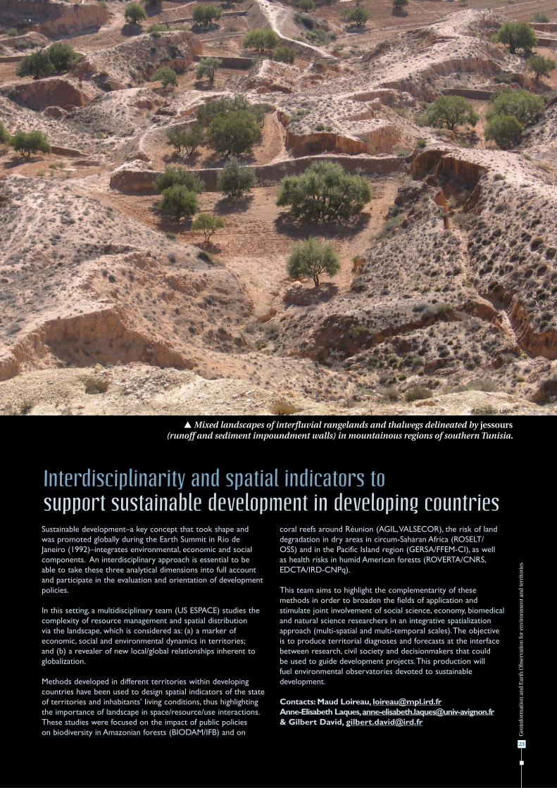
Sustainable development–a key concept that took shape and was promoted globally during the Earth Summit in Rio de Janeiro (1992)–integrates environmental, economic and social components. An interdisciplinary approach is essential to be able to take these three analytical dimensions into full account and participate in the evaluation and orientation of development policies.
In this setting, a multidisciplinary team (US ESPACE) studies the complexity of resource management and spatial distribution via the landscape, which is considered as: (a) a marker of economic, social and environmental dynamics in territories; and (b) a revealer of new local/global relationships inherent to globalization.
Methods developed in different territories within developing countries have been used to design spatial indicators of the state of territories and inhabitants’ living conditions, thus highlighting the importance of landscape in space/resource/use interactions. These studies were focused on the impact of public policies on biodiversity in Amazonian forests (BIODAM/IFB) and on
coral reefs around Réunion (AGIL, VALSECOR), the risk of land degradation in dry areas in circum-Saharan Africa (ROSELT/OSS) and in the Pacific Island region (GERSA/FFEM-CI), as well as health risks in humid American forests (ROVERTA/CNRS, EDCTA/IRD-CNPq).
This team aims to highlight the complementarity of these methods in order to broaden the fields of application and stimulate joint involvement of social science, economy, biomedical and natural science researchers in an integrative spatialization approach (multi-spatial and multi-temporal scales). The objective is to produce territorial diagnoses and forecasts at the interface between research, civil society and decisionmakers that could be used to guide development projects. This production will fuel environmental observatories devoted to sustainable development.
Contacts: Maud Loireau, [email protected] Anne-Elisabeth Laques, [email protected]& Gilbert David, [email protected]
Interdisciplinarity and spatial indicators to support sustainable development in developing countries
23
Mixed landscapes of interfluvial rangelands and thalwegs delineated by jessours (runoff and sediment impoundment walls) in mountainous regions of southern Tunisia.
P. Dérioz © UAPV

Geo
info
rmat
ion
an
d E
arth
Ob
serv
atio
n fo
r en
viro
nm
ent a
nd
terr
itor
ies
24
Controlling floods and water erosion, assessing, preserving and restoring the quality of water and soil resources, and evaluating environmental risks associated with land use are key environmental and agricultural challenges in the current setting of high population growth and cropping intensification. Distributed hydrological models are essential tools for gaining insight into hydrological processes in catchments and for predicting the impact of changes on the response of these catchments.
To represent the transfer of water and waterborne substances in agricultural catchments, digital landscape maps are required that take all elements in the landscape that may have an impact on these transfers into account. Different sources of geoinformation (topography, soil maps, presence of water bodies, plot patterns, crop species, plot management strategies) must be combined in such representations, as well as natural (streams) and human-induced (earth banks, ditches, edges of crop fields) discontinuities that could have a major impact on water transfers.
As part of its research on modelling the hydrology of small cultivated catchments, UMR LISAH has developed Géo-MHYDAS, which is an original three-step procedure for agricultural landscape delimitation and characterization. In the first step, geographical features of potentially different natures and sizes (soil units, subcatchments, farming plots, ditch networks, etc.) are imported. In the second step, all of this geoinformation is combined to create uniform hydrological units, while preserving the initial features but remaining compatible with the water transfer functions of the hydrological model, and with the user maintaining control over the hierarchical order so as to be able to combine the features according to his/her specific objectives. In the third step, an application-oriented topology is created to be able to simulate water flows through the landscape during the actual hydrological modelling phase. The original feature of Géo-MHYDAS is that it can take a broad range of different agricultural landscape characteristics into account while not classifying them only on a topographical basis.
Contacts: Philippe Lagacherie, [email protected] Michael Rabotin, [email protected]çois Colin, [email protected] Roger Moussa, [email protected]& Marc Voltz, [email protected]
Digital mapping of agricultural landscapesfor hydrological modelling
Spatial analysis and spatiotemporal modelling methods
Example of a digital chart of a vineyard landscape for hydrological modelling obtained with Geo-MHYDAS.
© L
ISA
H

Geo
info
rmat
ion
an
d E
arth
Ob
serv
atio
n fo
r en
viro
nm
ent a
nd
terr
itor
ies
25
Studies of many important issues that society faces today are based on a modelling approach. Insight is required prior to action–whether it concerns the emergence and spread of diseases associated with new environmental conditions, rapid transformations in urban areas, or the degradation of natural ecosystems and biodiversity loss. For a given issue: What are the key elements that make up the landscape? How do they interact? How does the landscape function and evolve as a system? As such systems can usually not be experimentally investigated in the field, studies often rely on computerized modelling, despite the inherent problems of spatial representation, time management and multiple spatial and temporal scales.
New tools are sought to solve these problems, such as a language specifically developed for modelling landscapes and for simulating their dynamics. The language elements should help scientists to accurately describe the composition of landscapes, to express the relations between their components, to specify how they evolve in time and to generate simulations according
to different experimental scenarios (e.g. a change in land-use legislation). In addition to the language, by this approach landscape elements, called ‘primitives’, can be compiled in libraries. Users have access to these libraries and are able to assemble the primitives required for modelling a given landscape.
This research is being conducted within the framework of the Spatial, Temporal and Multi-scale Primitives for Modelling Dynamic Landscapes (STAMP) project (2008-2010) supported by the French Research Agency’s Programme Blanc (i.e. open to all disciplines). Researchers from UMR TETIS and AMAP, the Institut National de Recherche en Informatique et en Automatique (INRIA) and the University of Marne-la-Vallée, along with scientists from a range of disciplines (epidemiology, agronomy, ecology, etc.) are jointly involved in this project.
Contacts: Pascal Degenne, [email protected]& Danny Lo Seen [email protected]
Modelling to gain insight into landscapeswhose changes affect society
A rural landscape and its different models.P. Degenne © CIRAD