Spate Irrigation Systems in Raya Valley...
47
13 Spate Irrigation Systems in Raya Valley (Ethiopia) Overview Paper Spate Irrigation
Transcript of Spate Irrigation Systems in Raya Valley...

13Spate Irrigation Systems in Raya Valley (Ethiopia)
Ov
erv
iew P
ap
er S
pa
te Irrig
atio
n

Ove
rvie
w P
ap
er
#1
3
ABSTRACT
The overall objective of this research was to evaluate the social, institutional, economic and technical performance of traditional spate irrigation systems in the Raya Valley and come up with recommendations that could improve their efficiency and sustainability. In view of this, impact of traditional spate irrigation on income of farmers; evaluation of field water management of traditional spate irrigation; evaluation of the performance of diversion structures; and social, institutional and management aspects of traditional spate irrigation were addressed in the study. Questionnaire, focused group discussion and field observation and monitoring approaches were employed for the collection of the required data and analysed using relevant techniques. The average yield of spate irrigation was always higher than rainfed as a result of the better moisture availability. The average annual household net income from both spate irrigation and rainfed production has increased during 2009 – 2011 as a result of increased market price of crops. The market price has shown an increase ranging from 29% for Sorghum to 138% for Onion. The amount of average annual household net income was generally small due to the relatively high production cost and dominant cereal cultivation characterized by low yield and market price. The contribution of spate irrigation to the total annual household net income was found to be 62% indicating its importance. However, the average household annual net income from spate irrigation of farmers in the top Tabias was 22% higher than those in the middle while the farmers in the middle Tabias generate 25.5% more annual net income than the top farmers. The moisture monitoring in selected field has revealed a poor water allocation among plots located at the top, middle and bottom of a water course. For instance, while the water demand of shallow rooted Teff in the top plot at any time was not more than 25 mm, the corresponding moisture available within its root zone was in excess of 200 mm. On the other hand, even if deep rooted Sorghum was sown in the middle plot, the available moisture in the top plot has been almost three times of the middle plot during the monitoring period. This clearly shows the unfair distribution of water among plots located at the top, middle and bottom of a scheme. The fact that the Maize planted in the bottom plot has failed during its initial growth stage further explains the situation. The study also found out that, with a failure of 13 of the 17 modern diversion systems constructed in Raya Valley, traditional spate diversions were performing better. Last but not least, traditional Sirit law led by water management committee consisting of Abo-Gerebs and Abo-Mais is used for operation and maintenance of spate irrigation. However, the fee collected from fines is usually used for purchase of drinks during social events of the community than for the maintenance of the traditional diversion structures. Efforts need to be made to strengthen the potentials and amend the challenges of traditional spate irrigation in the Raya Valley.
Key words: Performance, spate irrigation, rainfed production, yield, income, moisture monitoring, Sirit.
agricultural technologies (Daily Ethiopia News, 2010). However, the regional and national trend generally indicates that rainfed farming will still remain to play the major role in the agricultural production. Improving the productivity of rainfed agriculture by enhancing traditional water harvesting practices is, therefore, of equally important for the success of the plan.
Spate irrigation is one of the traditional practices employed by farmers in Tigray in general and the Raya Valley in particular to supplement rainfed agriculture. The Raya Valley, located in the Southern Zone of Tigray, is an agriculturally potential area for crop production, livestock grazing and browsing. The low land areas of the valley are surrounded by mountains and characterized by deep and fertile soil suitable for agriculture as a result of ages old alluvial deposition (COTWRD, 2005).
According to Haile (2009), the Valley is characterized by bimodal and unreliable rainfall ranging from 486 mm to 693 mm per annum. On the other hand, the Raya Valley has considerable surface water potential. In addition to the limited rainfall, the Valley benefits from seasonal flow of more than 15 streams and rivers. These streams and rivers come from the western and eastern highlands and produce about 170 million m3 annual surface runoff that drains to the Denakil Basin if not utilized (REST, 1996 quoted in Haile, 2009).
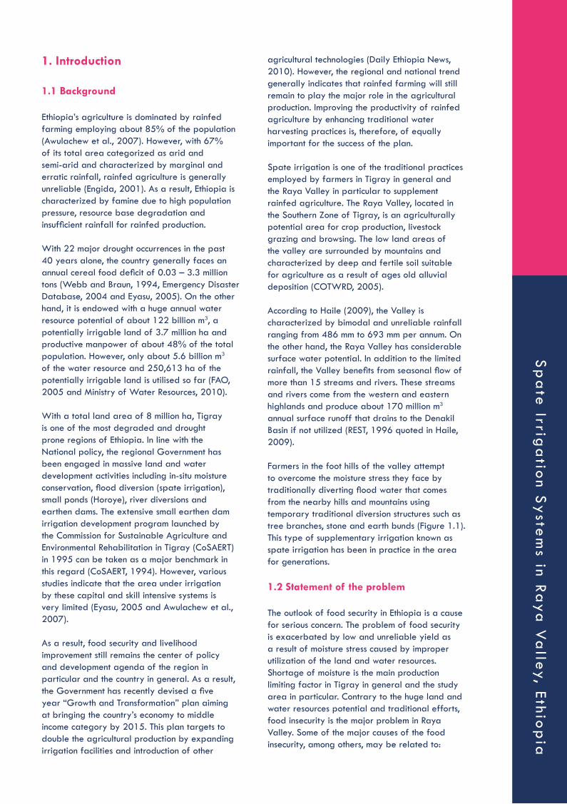
Farmers in the foot hills of the valley attempt to overcome the moisture stress they face by traditionally diverting flood water that comes from the nearby hills and mountains using temporary traditional diversion structures such as tree branches, stone and earth bunds (Figure 1.1). This type of supplementary irrigation known as spate irrigation has been in practice in the area for generations. 1.2 Statement of the problem
The outlook of food security in Ethiopia is a cause for serious concern. The problem of food security is exacerbated by low and unreliable yield as a result of moisture stress caused by improper utilization of the land and water resources. Shortage of moisture is the main production limiting factor in Tigray in general and the study area in particular. Contrary to the huge land and water resources potential and traditional efforts, food insecurity is the major problem in Raya Valley. Some of the major causes of the food insecurity, among others, may be related to:
1. Introduction
1.1 Background
Ethiopia’s agriculture is dominated by rainfed farming employing about 85% of the population (Awulachew et al., 2007). However, with 67% of its total area categorized as arid and semi-arid and characterized by marginal and erratic rainfall, rainfed agriculture is generally unreliable (Engida, 2001). As a result, Ethiopia is characterized by famine due to high population pressure, resource base degradation and insufficient rainfall for rainfed production.
With 22 major drought occurrences in the past 40 years alone, the country generally faces an annual cereal food deficit of 0.03 – 3.3 million tons (Webb and Braun, 1994, Emergency Disaster Database, 2004 and Eyasu, 2005). On the other hand, it is endowed with a huge annual water resource potential of about 122 billion m3, a potentially irrigable land of 3.7 million ha and productive manpower of about 48% of the total population. However, only about 5.6 billion m3 of the water resource and 250,613 ha of the potentially irrigable land is utilised so far (FAO, 2005 and Ministry of Water Resources, 2010).
With a total land area of 8 million ha, Tigray is one of the most degraded and drought prone regions of Ethiopia. In line with the National policy, the regional Government has been engaged in massive land and water development activities including in-situ moisture conservation, flood diversion (spate irrigation), small ponds (Horoye), river diversions and earthen dams. The extensive small earthen dam irrigation development program launched by the Commission for Sustainable Agriculture and Environmental Rehabilitation in Tigray (CoSAERT) in 1995 can be taken as a major benchmark in this regard (CoSAERT, 1994). However, various studies indicate that the area under irrigation by these capital and skill intensive systems is very limited (Eyasu, 2005 and Awulachew et al., 2007).
As a result, food security and livelihood improvement still remains the center of policy and development agenda of the region in particular and the country in general. As a result, the Government has recently devised a five year “Growth and Transformation” plan aiming at bringing the country’s economy to middle income category by 2015. This plan targets to double the agricultural production by expanding irrigation facilities and introduction of other
Sp
ate
Irriga
tion S
yste
ms in Ra
ya V
alley, Ethio
pia
• Poor field water management practices;• Poor performance of spate diversion
structures;• Poor performance of water management
institutions;• Poor return of production costs.
However, no comprehensive and integrated study has so far been carried out to investigate these aspects in detail and present the important issues that need due attention in the proper development and management of spate irrigation. This particular research was, therefore, initiated to fill this gap by trying to answer the following research questions:
• What is the impact of traditional spate irrigation scheme on yield and income of households compared to purely rainfed land?
• What is the status of field water management of the traditional spate irrigation systems?
• What is the technical performance of the traditional spate diversion structures in terms of durability, sedimentation and delivering water to farms?
• How is the social and institutional situation of traditional spate irrigation schemes in the Valley?
• How can the performance of the traditional spate irrigation systems be improved?
1.3 Objective of the study
1.3.1 General objectivesThe overall objective of this research was to evaluate the social, institutional, economic and technical performance of traditional spate irrigation systems in the Raya Valley and come up with recommendations that could improve their efficiency and sustainability.
1.3.2 Specific objectivesThis research has tried to address the following major specific objectives:• Assess the impact of traditional spate
irrigation systems on income of households;• Evaluate the field water management
performance of traditional spate irrigation practices;
• Comparative evaluation of the technical performance of traditional and modern spate diversion structures in terms of durability, sedimentation, water diversion efficiency, etc;
• Evaluate the social and institutional performance of traditional spate irrigation schemes in relation to participation of users, equity, operation and maintenance of the schemes, conflict and its resolution, and role of women in the entire process; and
• Propose recommendations that could improve the efficiency and sustainability of the traditional spate irrigation systems in the Raya Valley.
2. Literature Review
2.1 Introduction
Spate irrigation is a unique form of water resource management that has been practised in arid and semi-arid regions where evapotranspiration greatly exceeds rainfall.
In the report of an Expert Consultation on the subject, UNDP and FAO (1987) have defined spate irrigation as “an ancient irrigation practice that involves the diversion of flashy spate floods running off from mountainous catchments where flood flows, usually flowing for only a few hours with appreciable discharges and with recession flows lasting for only one to a few days, are channelled through short steep canals to bunded basins, which are flooded to a certain depth”.
Figure 1.1 Temporary traditional diversion structures used in the study area
Ove
rvie
w P
ap
er
#1
3

irrigation also remains at the heart of places like the bread basket of Yemen the Tihama and it is on the rise in several countries, for instance in the Horn of Africa (Van Steenbergen, 2010).
2.1.2 History of spate irrigationSpate irrigation has evolved and developed over a very long time period. The remains of diversion dams in ephemeral rivers dating from 3,000 BC can be seen in Iran and Balochistan, Pakistan (Nawaz, 2002).
It is thought that spate irrigation started in present-day Yemen, when the wet climate of the Neolithic period became more arid, and has been practised there for around five thousand years. The famous Mar’ib dam in Yemen, which irrigated 9,600 ha with spate flows diverted from the Wadi Dhana, was first constructed during the Sabian period in the third millennium BC (Hehmyer, 2000). It is reported that large volumes of sediment were scoured out of the dam when it was breached. Hehmyer (2000) suggests that the dam builders could have constructed a permanent masonry dam but chose an earthen impounding structure that would fail when overtopped by historic floods, to prevent very large flows from damaging the irrigated area.
In Yemen, large traditional spate systems consisting of numerous individual intakes and canals irrigating areas of up to 30,000 ha were developed in individual wadis. Sophisticated water sharing arrangements were formalized, with rules relating to water rights that exist in written records dating back at least 600 years.
In Pakistan, spate irrigation has been practised for a long period and it was the basis of important agricultural production systems until the end of the nineteenth century, when the development of perennial irrigation received an important impetus under the British colonial administration essentially by a reorganization of the water management arrangements (Nawa, 2003).
Spate water from about 26 wadis in the northwest coastal region of Egypt has been used for irrigation since Roman times (Moustafa and Allam, 1987) while spate irrigation has been practised in Morocco over a similar period. In central Tunisia, farmers have irrigated their fields with diverted spate water since the second half of the nineteenth century (Van Mazijk, 1988). In Iran, spate irrigation has a history of many millennia and can be seen in many forms, often combined with groundwater drainage galleries, so-called qanats.
Subsistence crops, often sorghum, are typically planted only after irrigation has occurred. Crops are grown from one or more irrigations using residual moisture stored in the deep alluvial soils formed from the sediments deposited in previous irrigations (Van Steenbergen et. al., 2010).
2.1.1 Definition and conceptsA simpler definition of spate irrigation was given by Mehari et al. (2007) as “a resource system, whereby flood water is emitted through normally dry wadis and conveyed to irrigable fields”. ICID (2010) distinguishes floodwater harvesting within streambeds, where channel flow is collected and spread through the wadi where the crops are planted, from floodwater diversion, where the floods or spates from the seasonal rivers are diverted into adjacent embanked fields for direct application.
In all these cases, spate irrigation is characterized by the arid environment in which it takes place, the unpredictable nature of flood water to be harnessed, high sediment loads and a complex social organization.
Sedimentation is a major factor in spate irrigation. Spate systems grow their own soils, and rely on nutrients transported with sediments from upstream catchments to maintain soil fertility. High sediment loads causes command areas to rise and block intakes and channels, but sedimentation processes can be manipulated for the benefit of farming. Spate irrigation is as much about sediment management as it is about water management (Lawrence, 2009).
Spate irrigation is the main source of livelihood for large numbers of economically marginal people in areas as varied as the Near East, Africa, South and Central Asia and Latin America, and is mostly practised outside the formal state-managed irrigation sector.
Generally, it is a subsistence activity, with low returns, generating highly variable incomes between good and bad years. It requires high inputs of labour to maintain intakes, canals and field systems and, in places where more reliable and rewarding livelihood opportunities are available, farmers tend to abandon their schemes, local management structures are undermined, and spate irrigation systems tend to decline and disappear.
This has been the case in some richer countries such as Saudi Arabia. On the other hand, spate
Sp
ate
Irriga
tion S
yste
ms in Ra
ya V
alley, Ethio
pia

2.1.3 Classification of spate irrigationThere are several variants of spate irrigation and several terms are used to describe similar practices. Spate irrigation has some similarities with flood inundation and flood recession systems found along alluvial plains, where crops are grown from the residual moisture following floods (Oudra, 2008).
The term water harvesting is also used to describe the practice in which the flow discharged from a small catchment area after a storm is directed through channels to a nearby field enclosed by bunds, and soil moisture is increased by subsequent infiltration, while runoff farming usually refers to in situ collection of rainwater in the field to increase moisture in the root zone. In all cases, the crops take up the supply of water in the soil during the dry periods that follow rainfall and they can survive longer periods without yield losses in places with deeper and heavier soils (Haile, et al., 2007).
There are two important features that distinguish spate irrigation from these other forms of flood irrigation. The first is that, in spate irrigation, flood water is physically diverted from wadi channels using canals to bunded fields that may be located at some distance from the water course. The second is that spate irrigation is carried out on a large scale, by groups of farmers rather than individuals, who need to work closely together to divert and distribute flood waters and maintain their intakes and canals.
Spate irrigation is also distinct from semi-perennial irrigation, as it depends on short duration floods, whereas semi-perennial irrigation makes use of flows lasting weeks, even months. In all cases, however, the dividing line is thin (Van Steenbergen et al., 2010). Common features of most spate irrigation schemes are:
• ingenious diversion systems, built to capture short floods but also designed to keep out the larger and most destructive water flows;
• sediment management, as the flood water has high sediment loads that would otherwise fill reservoirs and clog intake structures and distribution canals; these sediments are used to build up soil and level the land but can also result in excessive rising of land and loss of command;
• the importance of soil moisture conservation, especially as floods often come ahead of the sowing season;
• a sophisticated social organization to manage the sometimes complex system, ensure timely maintenance of the structures and channels and oversee the fair distribution of the flood water, even though it comes in unknown quantities at unpredictable times.
Schemes are usually designed for a given purpose and several classifications of the various types are possible. Table 2.1 (see other page) presents classifications based on size, infrastructure, management or hydrological regime and source of water.
Some pictures of spate diversion systems around the globe are presented below. A spur-type intake constructed from wadi bed material and pushed up by bulldozer at the outside of a river bend in a spate river in Pakistan (Figure 2.1).
The wide, shallow cross section of the diversion channel, typical of canals in spate systems, and the fine sediment deposits that have settled in the intake channel are well recognized. The photo also illustrates the intention of the farmers to take only a proportion of the peak wadi flood flow, at the same time abstracting as much of the lower and medium flows as possible. Although the examples shown above encompass intakes constructed in different ways, in wadis of differing sizes, catchment areas and flow characteristicsand at widely separated geographical locations, they share many common features (Nawaz, 2002).
Traditional spate irrigation in Yemen is a typical intake constructed from cobbles and gravel, reinforced with brushwood, located at the outside (left bank) of the wadi bend (Figure 2.2). The permanent diversion weir was constructed a few kilometers upstream from this intake but, as the intake capacity was insufficient to meet all of their water needs, farmers continued to use this and other traditional intakes to utilize excess flood flows from the larger floods that pass over the new diversion weir. This weir was one of the first in the programmed of donor support to improving spate irrigation systems in the area
Figure 2.1: Traditional spate irrigation intakes in Pakistan
Ove
rvie
w P
ap
er
#1
3

Characteristics Class Description
Size of scheme Small Range from a few hectares, usually located on tributary wadis in mountain regions, or in plains supplied by small wadis, with areas not exceeding 1000 ha.
Medium Schemes located mostly in plains supplied from small/medium wadis. Command areas ranging from a few hundred up to 5000 ha. Often a single tribe or social group manages these schemes.
Large Substantial systems that may have numerous off takes irrigating land areas of up to 20000-30000 ha. Complex water sharing rules have developed in some cases to control the distribution of flows between intakes operated by different tribes, villages or social groups
Infrastructure Traditional intakes and canals
Traditional diversions consisting of deflecting spurs or, in flatter plains areas, bunds that are constructed right across the flood channel. Canals are usually short and rarely include a secondary distribution system. Water is usually passed from field to field by breaking field bunds when the ponded water reaches a predetermined depth. In Pakistan, spate-system fields often have their own supply channels.
Improved traditional systems
Farmer implemented improvements could include flow throttling structures and rejection spillways near canal heads and drop structures and flow division structures in main canals. In some areas farmers may hire bulldozers to construct diversion bunds. When outside agencies support improvements, bulldozers may be provided at subsidized rates, and simple gabion or rubble masonry structures may be used at diversions. Improved water control structures may also be incorporated in the canal and field systems.
Modernized and new systems
In large systems, numerous traditional intakes are replaced with concrete diversion weirs, with sediment sluices. Owing to the high costs of permanent structures a single permanent weir often replaces many traditional intakes. In newer schemes, steep canals and sediment management structures are provided to minimize sedimentation.In new schemes, where farmers may not have the traditional skills needed to manage spate flows, a range of diversion types, including large semi-permanent soil bunds and small, simple diversion weirs, are used.
Operation andmaintenance
Traditionally managed
Farmers manage systems without assistance from outside agencies.
Managed by farmers withsupport from outside agencies
In some schemes varying levels of support from government or NGOs is provided to assist in construction and maintenance of intakes, although operation is usually left in the hands of the farmers.
Agency-managed
In some large, formally farmer-managed systems that have been modernized, the intakes and main canal systems are operated and maintained by irrigation agencies. In Yemen some of these systems are now being handed back to the farmers as part of irrigation management transfer efforts.
Sp
ate
Irriga
tion S
yste
ms in Ra
ya V
alley, Ethio
pia
Characteristics Class Description
Wadi flow regimes anduse of groundwater
Schemes that have access onlyto spate flows
At locations where only spates occur, it is necessary to divert water at high discharges if a reasonable proportion of the annual runoff is to be diverted.
Schemes that have access tosignificant base flows
High water diversion efficiency can be obtained in wadis where (a) there are small base flows for some months during and following the rainy season; (b) there are large numbers of small and medium floods; or (c) the off takes are located in flat plains areas where the floods have lost momentum and may last for long periods. In these cases, irrigation of areas located at the head of systems is reasonably assured, and irrigation practices resemble perennial irrigation. Spate irrigation from flood flows is carried out in the middle and lower reaches of the wadi.
Conjunctive use of spate and shallow round water
Where possible, access to groundwater substantially reduces the uncertainty inherent in spate irrigation and allows cropping of cash crops that cannot survive for long periods between watering. Spates are still diverted for irrigation, albeit at unpredictable intervals and volumes. Spate flows enhance the recharge of the shallow aquifers.
Table 2.1 Possible classifications of spate irrigation schemes
and subsequent designers could have learned many lessons from these experiences (Ward et al., 2000).
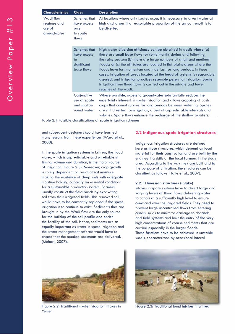
In the spate irrigation systems in Eritrea, the flood water, which is unpredictable and unreliable in timing, volume and duration, is the major source of irrigation (Figure 2.3). Moreover, crop growth is solely dependent on residual soil moisture making the existence of deep soils with adequate moisture holding capacity an essential condition for a sustainable production system. Farmers usually construct the field bunds by excavating soil from their irrigated fields. This removed soil would have to be constantly replaced if the spate irrigation is to continue to exist. Sediments that are brought in by the Wadi flow are the only source for the buildup of the soil profile and enrich the fertility of the soil. Hence, sediments are as equally important as water in spate irrigation and the water management reforms would have to ensure that the needed sediments are delivered. (Mehari, 2007).
2.2 Indigenous spate irrigation structures
Indigenous irrigation structures are defined here as those structures, which depend on local material for their construction and are built by the engineering skills of the local farmers in the study area. According to the way they are built and to the purpose of utilisation, the structures can be classified as follows (Haile et al., 2007).
2.2.1 Diversion structures (intake)Intakes in spate systems have to divert large and varying levels of flood flows, delivering water to canals at a sufficiently high level to ensure command over the irrigated fields. They need to prevent large uncontrolled flows from entering canals, so as to minimize damage to channels and field systems and limit the entry of the very high concentrations of coarse sediments that are carried especially in the larger floods.These functions have to be achieved in unstable wadis, characterized by occasional lateral
Figure 2.3: Traditional bund intakes in EritreaFigure 2.2: Traditional spate irrigation intakes in Yemen
Ove
rvie
w P
ap
er
#1
3
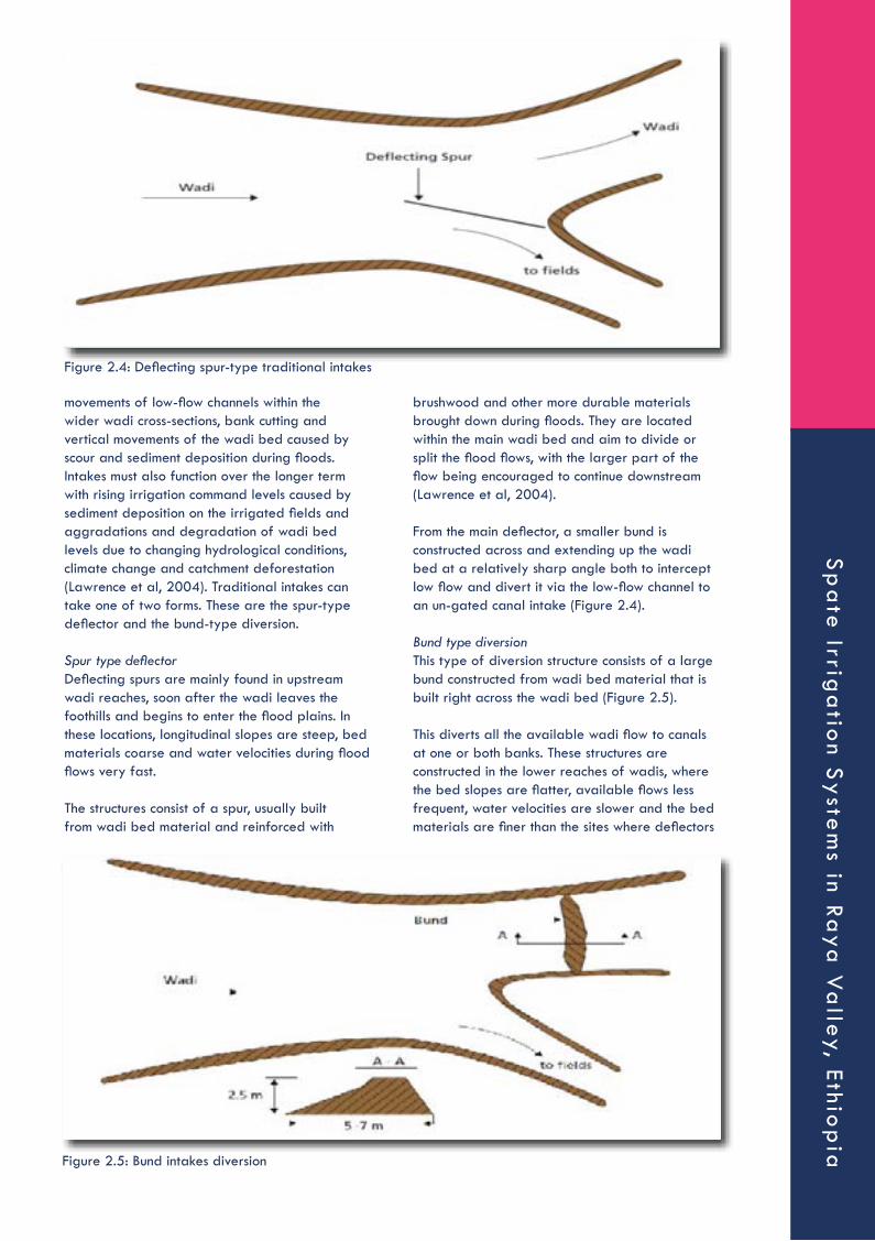
movements of low-flow channels within the wider wadi cross-sections, bank cutting and vertical movements of the wadi bed caused by scour and sediment deposition during floods. Intakes must also function over the longer term with rising irrigation command levels caused by sediment deposition on the irrigated fields and aggradations and degradation of wadi bed levels due to changing hydrological conditions, climate change and catchment deforestation (Lawrence et al, 2004). Traditional intakes can take one of two forms. These are the spur-type deflector and the bund-type diversion.
Spur type deflectorDeflecting spurs are mainly found in upstream wadi reaches, soon after the wadi leaves the foothills and begins to enter the flood plains. In these locations, longitudinal slopes are steep, bed materials coarse and water velocities during flood flows very fast.
The structures consist of a spur, usually built from wadi bed material and reinforced with
brushwood and other more durable materials brought down during floods. They are located within the main wadi bed and aim to divide or split the flood flows, with the larger part of the flow being encouraged to continue downstream (Lawrence et al, 2004).
From the main deflector, a smaller bund is constructed across and extending up the wadi bed at a relatively sharp angle both to intercept low flow and divert it via the low-flow channel to an un-gated canal intake (Figure 2.4).
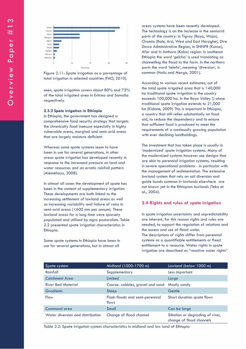
Bund type diversionThis type of diversion structure consists of a large bund constructed from wadi bed material that is built right across the wadi bed (Figure 2.5).
This diverts all the available wadi flow to canals at one or both banks. These structures are constructed in the lower reaches of wadis, where the bed slopes are flatter, available flows less frequent, water velocities are slower and the bed materials are finer than the sites where deflectors
Figure 2.4: Deflecting spur-type traditional intakes
Figure 2.5: Bund intakes diversion
Sp
ate
Irriga
tion S
yste
ms in Ra
ya V
alley, Ethio
pia

are used. All the wadi flow is diverted until the bund is overtopped and scoured out by a large flood or is deliberately cut by farmers (Lawrence et al, 2004).
2.2.2 Distributary canalsThese are generally permanent canals that convey water from the intake to the different zones of the spate irrigation scheme. Generally they have been sized to accommodate the maximum flood flow that can enter the intake and will deliver this flow proportionally between the lower level order channels.
2.2.3 Field channels (Bajur)The bajur is the channel leading water to the fields within a particular zone. The word is also used for the subsections (zones) in the command area. The purpose of the field channel is to deliver water to the agricultural lands in quantities proportional to the irrigated areas independent of the size of the flood in the wadi. Where distributary canals do not exist and water is delivered traditionally from field-to-field, the bajur conveys water directly from the diversion structure or agim to the first fields.
2.2.4 Spillway (Khala)These khala control the amount of water entering the fields. The structure is constructed on the side of the embankments of the field canals. The crest length of the spillways varies between 1.2 and 3.5 m with a free board that varies between 40 and 75 cm. They act as side or lateral spillways discharging flows that exceed the capacity of the field canals (bajur) back into the main canal. Khala are usually built on the earth embankments of the bajur. The crest of the khala is covered by grass or riprap to control erosion.
2.2.5 Drop structure (Mefjar)Mefjar structures are built in spate canals either when a canal has a steep longitudinal gradient; when water is transferred from a higher canal to a lower one; or when water is diverted from one field to another. The purpose is to dissipate flow
energy to minimize scouring. The structures are usually made from interlocked stones with gaps filled with smaller stones. In some cases the drop structure is covered only by grass. The width of these drop structures varies according to the size of the canals; the height typically varies between 40 to 60 cm.
2.2.6 Diversion structure (Agim)Agim is the Tigre terms for a structure that blocks and guides water. Agim is used to divert water from the wadis to the Musgha. It is a temporary structure and is susceptible to damage by floods. When it is submerged in water, it generates strong turbulence that makes it subject to being washed away. This structure is made from local materials available near the site, such as stones, soil and brushwood. It is usually constructed across the wadi bed and extends parallel to the current flow along the main canal. The common types of Agims are stone, soil, brushwood and mixed Agims. Pure brushwood Agims are rarely constructed as there is scarcity of brushwood and trees in the nearby vicinity.
Stone AgimsStone Agims are constructed from stones of varying size (Figure 2.6), which are collected from the banks of the wadi. Large stones and/or boulders are laid on the selected section of the wadi or main canal. The gaps between the large stones and/or boulders are filled with smaller size stones, which in turn are pressed from above with larger stones.
Soil AgimsSoil Agims are constructed from homogeneous wadi bed material, mostly sandy soil. They are common in places where other materials such as stones, boulders and brushwood are scarce and only found far away from the diversion site. To prevent frequent scouring, boulders or brushwood are placed on the upstream end (Figure 2.7).
Figure 2.6: Stone Agims Figure 2.7: Soil Agims
Ove
rvie
w P
ap
er
#1
3

of Africa (Ethiopia, Eritrea, Sudan, Somalia) and more sporadically in other parts of Africa, South America and Central Asia The development of spate irrigation in Eritrea is for instance traced back to the arrival of Yemeni migrants 80-100 years ago (Van Steenbergen et al., 2010). In several other parts of Africa, such as Ethiopia, spate irrigation is now just emerging, in response to increased population pressure in the highlands.
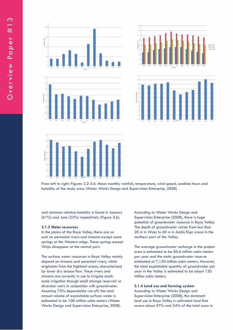
The most comprehensive information on the current extent of spate irrigation comes from data compiled by the Food and Agriculture Organization of the United Nations (FAO-AQUASTAT, 2010). FAO Aquastat has collected data obtained from governments and estimated there is a total area of 3.15 million ha of spate irrigation over 10 countries representing 13% of their irrigated area (Figure 2.10).
However, it is believed that “more informal” areas of small-farm spate irrigation can be found in other countries such as Sudan, Ethiopia, Egypt, Kenya, Mauritania and Senegal as well as Chile and Bolivia (FAO, 2010).
Figure 2.11 presents the percentage of area under spate irrigation compared to the total irrigated area of various countries. As it can be
Brushwood AgimsBrushwood Agims are constructed in the middle or at the bank of the wadi and are used to divert part of the stream. The brushwood is placed in such a way that the leaves face the upstream and the sticks downstream. Wooden piles (pieces of trunk) make up their core. Holes are excavated and the piles are put to a depth of 0.5 to 0.75 m into the ground. The holes are then compacted with wadi bed material and the piles are cushioned by brushwood (Figure 2.8).
Mixed AgimMixed Agim is constructed from earthen, stone and brushwood materials. The core of the structure is made of strong pieces of trunk; the outer part, which faces the floods, is reinforced with wooden piles and boulders; the bottom part is covered with earthen (sandy) materials. This Agim, as informed by the farmers, is the most resilient to flood damage. The boulders increase the stability of the Agim owing to their gravity, the brushwood trap some sediment and debris brought by the floods thereby filling the spaces between the inter-locking boulders further cementing the structure. Testimony to their resilience is the fact that mixed Agims are mainly constructed to divert flood water from a wadi to main canals. The (Figure 2.9) is one such mixed Agim.
2.3 Extent and distribution of spate irrigation schemes
2.3.1 Spate irrigation in the worldOne can only speculate as to how the practice spread across the world. However, the intense development of trade after the Islamic period may have helped to spread innovations from the Yemen area. spate irrigation is found in areas West Asia (Pakistan, Iran, and Afghanistan), the Middle East (Yemen, Saudi Arabia), North Africa (Morocco, Algeria, Tunisia) and the Horn
Figure 2.8: Brushwood Agim Figure 2.9: Indigenous diversion structure using mixed Agim
Figure 2.10 Estimated areas under spate irrigation (FAO, 2010)
Sp
ate
Irriga
tion S
yste
ms in Ra
ya V
alley, Ethio
pia
seen, spate irrigation covers about 80% and 75% of the total irrigated area in Eritrea and Somalia respectively.
2.3.2 Spate irrigation in EthiopiaIn Ethiopia, the government has designed a comprehensive food security strategy that targets the chronically food insecure especially in highly vulnerable areas, marginal and semi-arid areas that are largely moisture deficient.
Whereas some spate systems seem to have been in use for several generations, in other areas spate irrigation has developed recently in response to the increased pressure on land and water resources and an erratic rainfall pattern (Alemehayu, 2008).
In almost all cases the development of spate has been in the context of supplementary irrigation. These developments are both linked to the increasing settlement of lowland areas as well as increasing variability and failure of rains in semi-arid areas (<600 mm per annum). These lowland areas for a long time were sparsely populated and utilised by agro pastoralists. Table 2.2 presented spate irrigation characteristics in Ethiopia.
Some spate systems in Ethiopia have been in use for several generations, but in almost all
areas systems have been recently developed. The technology is on the increase in the semiarid parts of the country: in Tigray (Raya, Waja), Oromia (Bale, Arsi, West and East Haraghe), Dire Dawa Administrative Region, in SNNPR (Konso), Afar and in Amhara (Kobo) region. In southeast Ethiopia the word ‘gelcha’ is used translating as channelling the flood to the farm. In the northern parts the word ‘telefa’, meaning ‘diversion’, is common (Hailu and Merga, 2001).
According to various recent estimates, out of the total spate irrigated area that is 140,000 ha traditional spate irrigation in the country exceeds 100,000 ha. In the Raya Valley () alone traditional spate irrigation extends to 21,000 ha (Kidane, 2009) This is important in Ethiopia, a country that still relies substantially on food aid, to reduce the dependency and to ensure that sufficient food is produced to meet the requirements of a continually growing population with ever declining landholdings.
The investment that has taken place is usually in ‘modernized’ spate irrigation systems. Many of the modernized systems however use designs that are akin to perennial irrigation systems, resulting in severe operational problems - in particular with the management of sedimentation. The extensive lowland system that rely on soil diversion and guide bunds common in lowlands elsewhere are not known yet in the Ethiopian lowlands (Teka et al., 2004).
2.4 Rights and rules of spate irrigation
In spate irrigation uncertainty and unpredictability are inherent, for this reason rights and rules are needed, to support the regulation of relations and the access and use of flood water. The descriptions of rights differ from perennial systems as a quantifiable entitlements or fixed entitlement to a resource. Water rights in spate irrigation are described as “reactive water rights”
Figure 2.11: Spate irrigation as a percentage of total irrigation in selected countries (FAO, 2010).
Table 2.2: Spate irrigation system characteristics in midland and low land of Ethiopia
Spate system Midland (1000-1700 m) Lowland (below 1000 m)Rainfall Supplementary Less importantCatchment Area Limited LargeRiver Bed Material Course- cobbles, gravel and sand Mostly sandyGradients Steep GentleFlow Flash floods and semi-perennial
flowsShort duration spate flows
Command area Small Can be largeWater diversion and distribution Change of flood channel Siltation or degrading of river,
change of flood channels
Ove
rvie
w P
ap
er
#1
3

since they describe agreed claims and acceptable practices in a changing and variable environment (Lawrence et al., 2004).
The rules for water distribution enable farmers to be surer of irrigated land, which can even be prepared before cultivation with pre-flooding. In most (traditional) spate irrigation systems maintenance requires much labour for (re)constructing of the diversion works and flood channels. Willingness to contribute is also based on sharing the benefits, which is established by giving rights. The likelihood of irrigation enables people to work together and collectively contribute to the required maintenance and operation. Rights and rules are also important to adapt to changes in the wadi morphology on the medium and long term. Spate irrigation systems have to deal with increased land levels, and changed wadi courses and flood canals. The most common and widely applied rights and rules (Van Steenbergen et al., 2010) relate to the following:
2.4.1 Demarcation of land entitled to irrigationThis rule precedes all other rules and defines the area entitled to be irrigated. It protects the prior right of water users against changes of river courses and flood breaches. It prohibits new land development upstream and thus new diversions of flood water in order to not affect the downstream users. This can be a serious issue especially for areas with relatively new irrigation development. With the demarcation of outer boundaries overspill from breaches can be settled to avoid drainage losses.
2.4.2 Rules on breaking diversion bunds The breaking of bunds interrupts the inundation impounded between bunds. Water is released when a certain depth has been reached or a certain time has elapsed. These time-slots are based on agreements between farmers. Not everybody is allowed to breach bunds. So also the terms on when breaching is allowed and by who are considered.
2.4.3 Proportion of the flow going to different flood channels and fieldsThe distribution of water between different channels and the allocation is arranged within this settlement. Agreement can be made about the proportional division and or rotational distribution of water. In traditional systems crude hydraulic structures are mostly used. Discharges of flows can be adjusted by adjusting the width or blocking certain structures.
2.4.4 Sequence in which the different fields along a flood channels are wateredRights and rules about the sequence of the flood ensure entitled irrigation to certain plots, priority is given to certain main and branch canals. Also the order in which irrigation will take place can be considered. Based on the size of the flood the sequence can be adapted which allows priority to either upstream, midstream or downstream users. In this way priority channels can flow if a flood is small.
Figure 2.12: Traditional spate irrigation in the Raya Valley
Sp
ate
Irriga
tion S
yste
ms in Ra
ya V
alley, Ethio
pia

2.4.5 The depth of irrigation that each field is to receiveIn many spate irrigation systems with field to field water distribution, the depth is used to assure a certain amount of water is impounded. The depth for irrigation can vary and is based on the height of the field bund and the levelling of the fields. The irrigation depth is according to the size of the fields and the amount of flood events in order to impound a certain amount of flood water.
2.4.6 Practice regarding second and third water turnsThis rule allows fields to be irrigated more than once. The amount of irrigation terms can have a significant impact on the yields. Regarding the location of the water users within the scheme, repeat applications can be a dilemma and rules vary. Difference in priority of irrigation can be made for certain special crops. Another aspect is the size of the floods, which can make it hard to reach downstream users. Finally the size of the command area significantly influences the likelihood to receive a second turn.
2.4.7 Rules on small and big floodsDifferent priorities on the distribution of varying floods to water user’s upstream, midstream and downstream can be established. This allows the floods to be used efficiently like for small floods, which cannot even reach downstream.
2.5 Operation and maintenance
Spate Irrigation systems have diverse management arrangements. The management can be completely controlled by the farmers. Another possibility is joint management, where the farmers are assisted by outside agencies, like government agencies or NGO’s. Finally, schemes can be agency managed, which is sometimes used in schemes after large public investments.The government is becoming more important to mediate in disputes and oversee operation and management for larger systems. Spate irrigation goes along with extremes of either zero or the maximum discharge, this is different from perennial irrigation schemes, which operates within a fairly narrow range (Haile and van Steenbergen 2007).
In many spate systems the area prepared for irrigation, is larger than can be irrigated in an average year. Van Steenbergen (1997) has shown how in some cases many diversion structures are extended along a wadi to divert all available water, but the probability for land to receive water depends on the location and the level of the fields.
3 MATERIALS AND METHODS
3.1 Description of the study area
3.1.1 Location and populationThe Raya Valley is administratively located in the Raya Azebo and Alamata Weredas, Southern Zone of the Tigray National Regional State. It is geographically situated between 12o16’ and 12o55’ N latitudes and 39o22’ and 39o53’ E longitudes.
The proposed project area is located about 600 Kilometers north of Addis Ababa and 180 Kilometers South of Mekelle (the Regional capital). It is bordered by the Afar National Regional State to the East; the Amhara National Regional State to the South; part of Ofla and Enda Mehoni Weredas to the West and Alaje and Hintalo Weredas of Tigray region to the North (Figure 3.1).
The total population of the Alamata and Raya Azebo Weredas in 2006 was 97,576 and 129,438 respectively (Table 2) (Water Works Design and Supervision Enterprise, 2008).
As it can be seen, only 8.7% and 7.7% of the total population of Alamata and Raya Azebo Wereda lives in urban areas respectively, while female accounts about 51% of the total population of both Weredas. The 2013 projected population of Alamata and Raya Azebo Wereda is 118,002 and 152,628 (Water Works Design and Supervision Enterprise, 2008).
Figure 3.1: Location of the Raya Valley (Water Works Design and Supervision Enterprise, 2008)
Ove
rvie
w P
ap
er
#1
3

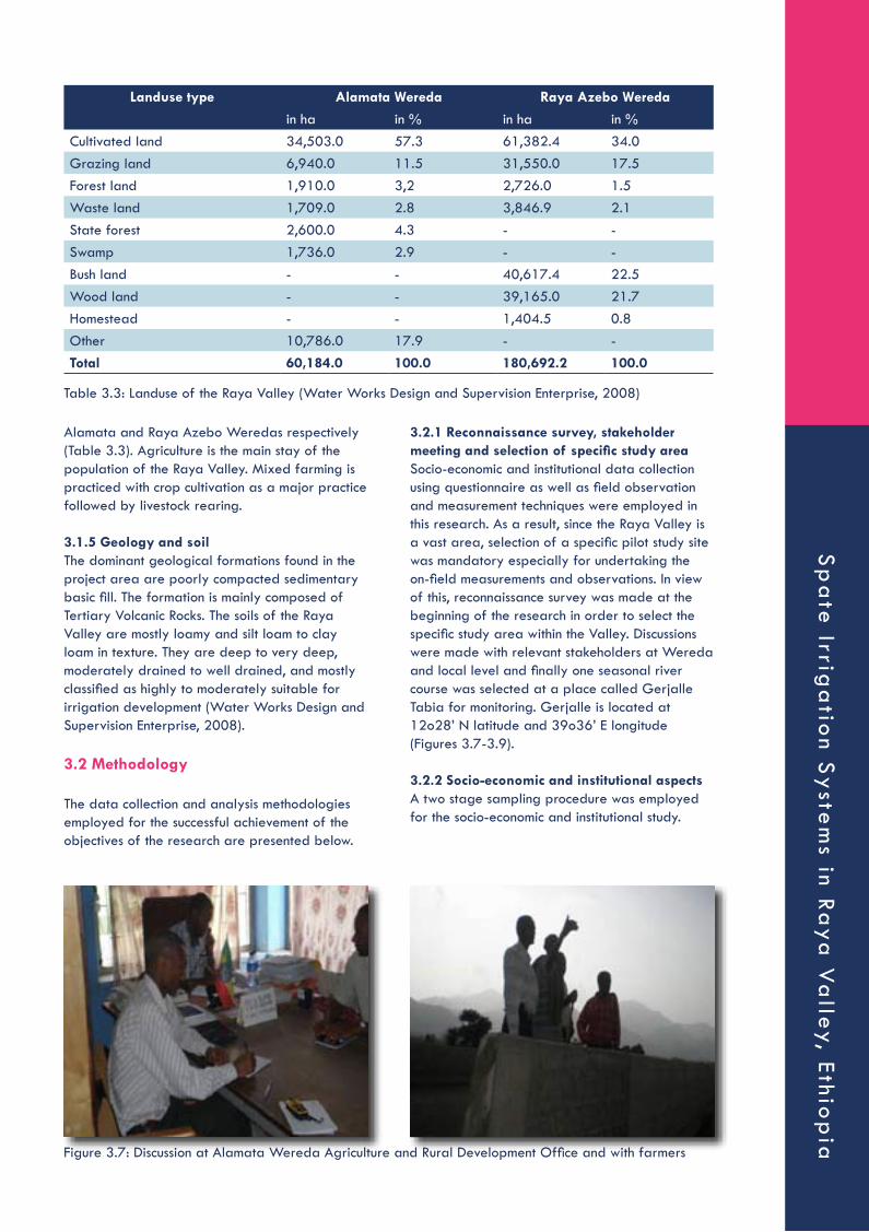
TemperatureThe maximum air temperature occurs in June (33.9 degrees), the minimum air temperature is occurs in December (11.5 degrees) and the mean annual temperature of the study area is 23.33 degrees (Figure 3.3).
Wind speedLike other hydrological elements wind speed has also a strong influence on the principal hydrologic cycle. The maximum and minimum wind speed is obtained in January (3.34 m/s) and November (1.11 m/s) respectively (Figure 3.4).
Solar radiationThe radiant energy from the sun is the main source of energy at the earth’s surface which drives the hydrologic cycle such as evaporation and is largely affected by sunshine duration. The maximum sunshine hour is recorded in November (9.1 hrs) and the minimum one is in July (5.7 hrs) (Figure 3.5).
Relative humidityRelative humidity indicates the amount of moisture stored in the air. The higher the relative humidity means lower evapotranspiration. The maximum
3.1.2 ClimateThe seasonal distribution of rainfall in the area is associated with the annual progression of the Inter Tropical Convergence Zone (ITCZ). This low pressure area of convergence between tropical Easterlies and equatorial Easterlies causes equatorial disturbance. The area is characterized by a bimodal rainfall pattern with a short rainy season “Belg” from February to March and a long rainy season “Kiremt” from June to September with a peak in August. The other months of the year are generally dry and there may be little rain in any month of the year. The Valley is generally characterized by semi-arid climate and the rainfall pattern is relatively erratic and unpredictable (Water Works Design and Supervision Enterprise, 2008). The monthly data of most important climatic variables of the study area are given in Table 3.2.
RainfallRainfall is a major factor controlling the hydrology of the area. It is the main input of water to the earth’s surface and for surface water potential analysis. The maximum and minimum monthly rainfall is obtained in August (192 mm) and November (20.6 mm) respectively (Figure 3.2).
Alamata Wereda Raya Azebo Wereda
Gender Urban Rural Total Urban Rural TotalMale 4,181 43,631 47,812 4,204 59,669 63873Female 4,353 45,411 49,764 5,760 59,805 65,565
Total 8,534 89,042 97,576 9,964 119,474 129,438
Table 3.1: Population of the Raya Valley in 2006 (Water Works Design and Supervision Enterprise, 2008)
Month Rainfall (mm) T m i n (OC)
T m a x (OC)
T a v g (OC)
RH (%) Windspeed (m/s)
S u n s h i n e duration (hr)
Total 75% (dep.) Jan 38.3 0.0 12.3 27.2 19.7 61.0 2.89 7.9Feb 37.4 0.0 12.7 28.1 20.4 57.0 2.06 7.7Mar 62.6 22.0 14.6 29.2 21.9 50.0 2.11 8.1Apr 81.5 34.0 15.7 29.9 22.8 51.0 1.90 8.1May 62.8 9.0 16.4 32.3 24.3 42.0 1.68 8.4Jun 18.0 1.0 17.7 33.9 25.8 33.0 1.94 6.6Jul 114.2 49.0 17.8 31.9 24.9 46.0 1.92 5.7Aug 192.0 89.0 17.8 30.8 24.3 58.0 1.60 6.2Sept 65.4 28.0 15.7 30.8 23.2 61.0 1.20 6.7Oct 28.2 2.0 13.9 29.8 21.9 53.0 1.30 8.6Nov 20.6 0.0 12.8 28.8 20.8 47.0 1.46 9.1Dec 22.2 17.0 11.5 27.8 19.6 56.0 1.61 8.3Average 61.9 20.9 14.9 30.0 22.5 51.3 1.8 7.6
Table 3.2: Climatic data of the study area (Water Works Design and Supervision Enterprise, 2008)
Sp
ate
Irriga
tion S
yste
ms in Ra
ya V
alley, Ethio
pia
and minimum relative humidity is found in January (61%) and June (33%) respectively (Figure 3.6).
3.1.3 Water resourcesIn the plains of the Raya Valley, there are as such no perennial rivers and streams except some springs at the Western edge. These springs except Waja disappear at the central part.
The surface water resources in Raya Valley mainly depend on streams and perennial rivers, which originates from the highland areas, characterized by lower dry season flow. These rivers and streams are currently in use to irrigate small-scale irrigation through small storage reservoir or diversion weirs in conjunction with groundwater. Assuming 75% dependable run-off, the total annual volume of exploitable surface water is estimated to be 100 million cubic meters (Water Works Design and Supervision Enterprise, 2008).
According to Water Works Design and Supervision Enterprise (2008), there is huge potential of groundwater resource in Raya Valley. The depth of groundwater varies from less than 20 m in Waja to 60 m in Addis Kign areas in the northern part of the Valley.
The average groundwater recharge in the project area is estimated to be 85.6 million cubic meters per year and the static groundwater reserve estimated at 7,150 million cubic meters. However, the total exploitable quantity of groundwater per year in the Valley is estimated to be about 130 million cubic meters.
3.1.4 Land use and farming systemAccording to Water Works Design and Supervision Enterprise (2008), the dominant land use in Raya Valley is cultivated land that covers about 57% and 34% of the total area in
From left to right: Figures 3.2-3.6: Mean monthly rainfall, temperature, wind speed, sunshine hours and humidity of the study area (Water Works Design and Supervision Enterprise, 2008)
Ove
rvie
w P
ap
er
#1
3
3.2.1 Reconnaissance survey, stakeholder meeting and selection of specific study areaSocio-economic and institutional data collection using questionnaire as well as field observation and measurement techniques were employed in this research. As a result, since the Raya Valley is a vast area, selection of a specific pilot study site was mandatory especially for undertaking the on-field measurements and observations. In view of this, reconnaissance survey was made at the beginning of the research in order to select the specific study area within the Valley. Discussions were made with relevant stakeholders at Wereda and local level and finally one seasonal river course was selected at a place called Gerjalle Tabia for monitoring. Gerjalle is located at 12o28’ N latitude and 39o36’ E longitude (Figures 3.7-3.9).
3.2.2 Socio-economic and institutional aspectsA two stage sampling procedure was employed for the socio-economic and institutional study.
Alamata and Raya Azebo Weredas respectively (Table 3.3). Agriculture is the main stay of the population of the Raya Valley. Mixed farming is practiced with crop cultivation as a major practice followed by livestock rearing. 3.1.5 Geology and soilThe dominant geological formations found in the project area are poorly compacted sedimentary basic fill. The formation is mainly composed of Tertiary Volcanic Rocks. The soils of the Raya Valley are mostly loamy and silt loam to clay loam in texture. They are deep to very deep, moderately drained to well drained, and mostly classified as highly to moderately suitable for irrigation development (Water Works Design and Supervision Enterprise, 2008).
3.2 Methodology
The data collection and analysis methodologies employed for the successful achievement of the objectives of the research are presented below.
Landuse type Alamata Wereda Raya Azebo Wereda
in ha in % in ha in %Cultivated land 34,503.0 57.3 61,382.4 34.0Grazing land 6,940.0 11.5 31,550.0 17.5Forest land 1,910.0 3,2 2,726.0 1.5Waste land 1,709.0 2.8 3,846.9 2.1State forest 2,600.0 4.3 - -Swamp 1,736.0 2.9 - -Bush land - - 40,617.4 22.5Wood land - - 39,165.0 21.7Homestead - - 1,404.5 0.8Other 10,786.0 17.9 - -Total 60,184.0 100.0 180,692.2 100.0
Table 3.3: Landuse of the Raya Valley (Water Works Design and Supervision Enterprise, 2008)
Figure 3.7: Discussion at Alamata Wereda Agriculture and Rural Development Office and with farmers
Sp
ate
Irriga
tion S
yste
ms in Ra
ya V
alley, Ethio
pia

The first stage involved the selection of the representative Tabias to be included in the survey. Purposive sampling technique in consultation with the project Wereda Agricultural and Rural Development Offices was used to determine the Tabias. Alamata Wereda constitutes 18 Tabias one of which is the specific study site – Garjalle Tabia. In additional to Garjalle, four more Tabias were included in the study. The four additional Tabias were purposely selected based on the following criteria:
• Relative location from Alamata town: Two Tabias on each side of the Alamata town; and
• Relative location in a river course: Two of the Tabias located at the top of a river course while the remaining two are located at lower reach.
The second stage involved a systematic random sampling for the selection of respondents from each Tabia in view of acquiring an average representative data. Primarily, the household head lists of the selected Tabias were obtained from the Administration and Development Agent offices. The Tabia household heads were then categorized into two age groups, namely, below and above 45 years.
These households were further categorized into three performance groups, namely, best, medium and poor in consultation with Development agents and elders. Two respondents were randomly selected from each category resulting in 12 household heads per Tabia. In addition, 3 female headed households were included. The total respondents per Tabia were, therefore, 15 resulting in a total of 75 farm households (Table 3.4).
Social, institutional and management aspects of traditional spate irrigationData related to the social and institutional aspects of the traditional spate irrigation schemes such as participation of users, equity, operation and maintenance of the schemes, conflict and its resolution, and role of women in the entire process were collected from selected households using questionnaire (Annex I). The household data collection was carried out after the questionnaire was prepared and tested.
Impact of traditional spate irrigation on income of farmersThe impact of the traditional spate irrigation systems on income of households was compared with rainfed agriculture in the area. Questionnaire was used for the collection of income and expenses of the selected households (Annex II and III).
Primary and secondary data related to price of agricultural inputs and yields, and amount of inputs applied and yield earned by household for both rainfed and spate systems were collected. Consideration was also given to the number of cultivations per year of the two systems. In addition, the extra annual investment on traditional spate irrigation systems was taken into account. Efforts were also made to assess the situation in a multilayer perspective, i.e, the yield of the past few years were collected and the water supply and yield situation of those years compared to the current season. Finally, the net income per a unit of area of both systems was calculated, compared and conclusion produced.
3.2.3 Evaluation of field water management of traditional spate irrigationThe methods and procedures followed in the assessment of the field water management of traditional spate irrigation are presented below.
Figure 3.8: Location of the study Tabia (Gerjalle) and plots selected for field monitoring and data collection
Figure 3.9: The seasonal river course selected at Gerjalle for monitoring the study
Ove
rvie
w P
ap
er
#1
3

in changes in electrical resistance between the electrodes in the sensor. The electrical resistance can then be converted to soil water potential (Centibars) (Thomson, S. J. and Armstrong C. F., 1987).
The soil acts as a reservoir to store water between irrigations or rainfall events, so that it is available to the crop or plants as needed for healthy growth. The purpose of using sensors to measure soil water is to give a better understanding of how fast water is being depleted in the different areas of a field, so that irrigations can be better scheduled and the effectiveness of any rainfall can be correctly evaluated (Thomson, S. J. and Armstrong C. F., 1987).
It is important to install several stations of Watermark sensors in a field to get a good moisture reading accuracy, especially if the field includes several soil types. A station should have sensors placed at multiple depths depending on the crop grown (and effective root zone depth). This is to evaluate moisture movement and depletion within the root zone over time and with crop water use.
Selection of plotsThree farm plots were selected for this purpose based on:
• Location: top, middle and downstream of the selected seasonal river course;
• Major crop type: teff, sorghum and maize.
Determination of daily water supply and demandA) Determination of actual daily available soil moisture in the plots.The daily actual soil moisture available within the root zone of the crops in the plots was recorded using Watermark digital data logger from cables buried in the soil profile (Figure 3.10 and Figure 3.11).
Watermark is a granular matrix sensor similar to a gypsum block, while the Watermark sensor differs in that it is more durable in the soil and may be more responsive to changes in soil moisture. It consists of two concentric electrodes embedded in a reference matrix material, which is surrounded by a synthetic membrane for protection against deterioration. A stainless steel mesh and rubber outer jacket make the sensor more durable than a gypsum block. Movement of water between the soil and the sensor results
Performance group Numbers of household randomly selected
From the general population Female headedBelow 45 years age Above 45 years age
Best performing 2 2 1Medium performing 2 2 1Low performing 2 2 1Total 6 6 3
Table 3.4: Number and category of farm household heads included in the survey
Figure 3.10: Moisture reading using Watermark digital data logger from buried monitoring electrodes
Sp
ate
Irriga
tion S
yste
ms in Ra
ya V
alley, Ethio
pia

In view of the aforementioned guidelines, the cables were installed at the top, middle and bottom of each plot in order to monitor the horizontal distribution of the flood supplied to the farms. Similarly, three cables were buried at each location (0 – 30 cm, 30 – 60 cm and 60 – 90 cm) to monitor the vertical distribution (Figure 3.12).
The electrodes were first soaked before installation to ensure the accuracy of the sensor response. At saturation, the Watermark digital data logger should give a zero centibar pressure reading. Afterwards, the electrodes were wrapped by a saturated soil paste and pushed into a hole drilled by auger in the soil to the desired depth at the various locations of the plots. The pressure reading was then made at 8:00 am daily and recorded.
Since the calibration curve of the Watermark was missing, the soil moisture characteristics curve developed based on laboratory analysis results determined at Mekelle University was used to convert the Watermark soil water potential reading to the corresponding soil moisture content. The soil moisture characteristics curve represents the relationship between the soil water tension and its volumetric water content. It is constructed by determining the water content of the soil at a number of soil moisture tensions, namely, saturation, field capacity (FC) and permanent wilting point (PWP).
Infiltration test was also carried out for use in explaining the water movement in the soil profile when necessary. Double ring infiltrometer was used for determining the infiltration characteristics of the soil of the study area. The double ring infiltrometer consists of an inner and outer ring. The rings were driven into the soil, filled with water and infiltration in the inner ring recorded. The water between the outer and the inner ring forms a clear and distinct boundary condition for the water infiltrating within the inner ring (Figure 3.13).
B) Determination of daily water demand of the crops.The daily water demand of the crops was determined using the CROPWAT 8 computer software developed by FAO (FAO, 2009). CROPWAT 8 is a computer program that can calculate crop water and irrigation requirements/scheduling from climatic, soil and crop data. The program is interactive in nature. In addition, the program allows the development of irrigation schedules for different management conditions and the estimation of scheme water supply for varying cropping patterns. The program is based on a water balance model where the soil moisture status is determined on a daily basis from calculated evapotranspiration and inputs of rainfall and irrigation.
The climatic data required by the CROPWAT 8 include rainfall, temperature, humidity, wind speed and sunshine hours. These data were acquired from a hydrological study report of the area produced by Water Works Design and Supervision Enterprise (2008) of the Ministry of Water Resources (Table 3.2).The most important soil data required by the CROPWAT 8 software are the soil moisture holding capacity at Field Capacity (FC) and Permanent Wilting Point (PWP). For this purpose, disturbed and undisturbed soil samples were collected from three locations within each farm (top, middle and bottom) and three depths (0 – 30 cm, 30 – 60 cm and 60 – 90 cm) at each location.
Figure 3.11: The Watermark. Figure 3.12: Installation of soil moisture monitoring electrodes in the plots
Figure 3.13: Double ring infiltrometer
Ove
rvie
w P
ap
er
#1
3
Comparative evaluation of the performance of the traditional and modern spate systems such durability, sedimentation and water diversion efficiency was then carried out based on field observation, individual and focused group discussion with farmers and stakeholder workshop.
A preliminary report was first prepared based on secondary document review, field observation and discussion and presented to a workshop attended by a wide range of stakeholders. The preliminary findings were deliberated and further improved in the workshop. The participants of the workshop include:
• Researchers from Mekelle University;• Representatives of relevant regional offices
such as Bureau of Water Resources and IFAD;• Administrator, head of the Office of
Agriculture and Rural Development and head of the Office of Water Resources and Energy of Alamata Wereda;
• Relevant experts from the Alamata Wereda Offices of Agriculture and Rural Development and Water Resources and Energy;
• Development agent, Tabia administrator, Chairman of the traditional Water Users Association (Abo Mai) and male and female farmer representatives of the specific study site (Gerjalle Tabia); and
• Development agent, Chairman of the traditional Water Users Association (Abo Mai) and male and female farmer representatives of the additional 4 Tabias included in the socio-economics and institutional study.
4. RESULTS AND DISCUSSION
4.1 Impact of traditional spate irrigation on income of farmers
4.1.1 Data consistency analysisAs indicated in the methodology, five Tabias were included in the survey and respondents were asked to provide best estimate of yield of crops they harvested from spate irrigation and rainfed agriculture for the research year (2011) and two preceding years and relate the yields with corresponding relative moisture situation.
Table 4.2 presents the rating by respondents of the moisture situation of rainfed production and spate irrigation of the surveyed Tabias during 2009 – 2011 while Table 4.3 presents the corresponding average yield. However, the outcome of the survey depends on the consistency of the data provided by the respondent households for the different years.
The disturbed and undisturbed soil samples soil samples were used to determine the moisture content of the soil at permanent wilting point and field capacity respectively at Mekelle University soil laboratory. The soil samples were saturated, a state where all pore spaces are filled with water, and a pressure of 0.33 bars and 15 bars were applied for field capacity and permanent wilting point respectively. Then, the samples were placed in oven at 105 oC for 24 hours to determine the gravimetric moisture content held in the soil at FC and PWP. The gravimetric soil moisture was finally multiplied by its bulk density to get the corresponding volumetric value.
The undisturbed soil samples taken by core-samplers were used for the determination of bulk density by core method.
• Gravimetric Moisture Content (%) = (Weight of water/Weight of dry soil) * 100
• Volumetric Moisture Content (%) = Gravimetric Moisture Content (%) * Bulk density
Evaluation of the field water management practiceAs presented earlier, crop production using rainfall alone is not a viable option in Raya Valley. However, the use of seasonal flood that comes from adjacent highlands as supplementary spate irrigation along with the fertile alluvial deposition has made the Valley one of the leading agriculturally potential areas of crop production in Tigray. Unfortunately, flood is a rare occurrence in low land dry lands such as Raya Valley. The efficient and effective use of this flood, therefore, becomes very vital in order to minimize unnecessary losses and maximize the area that can be irrigated. In view of this:
• The actual daily soil moisture available within the root zone of the plots was compared with the corresponding daily water demand of the crops; and
• The water utilization efficiency of the plots evaluated.
3.2.4 Evaluation of the performance of diversion structuresThere are two types of spate diversion systems in Raya Valley, namely, modern and traditional spate diversion. Detailed descriptions of the two systems including construction materials, site selection, design, construction and diversion concepts and principles were recorded based on field observation and review of secondary documents.
Sp
ate
Irriga
tion S
yste
ms in Ra
ya V
alley, Ethio
pia

As a result, linear correlation analysis between average yield and moisture situation data among the three survey years (2009 – 2011) was carried out for each Tabia. In addition, correlation analysis between the average yield and moisture situation of the entire surveyed Tabias was also made (Table 4.1).
The result shows a high coefficient of correlation between the yield and moisture situation of the survey years. This clearly indicates that the data provided by the interviewees is consistent and can be used for describing the situation of the study area.
4.1.2 Moisture situation, average yield and price of major crops under rainfed and spate irrigationThe major crops of rainfed agriculture are Sorghum and Teff while Maize and Onion are additional crops cultivated in traditional spate irrigation in the study area (Table 4.3).
Table 4.3 clearly indicates that the average yield of spate production is always higher than rainfed as a result of the better moisture availability in spate irrigation. According to the feedback from the respondents, the overall average moisture situation of spate during 2009 – 2011 was categorized as high while it was rated as normal for rainfed production. As a result, the average yield of Sorghum from spate irrigation was 25% higher than the rainfed while the corresponding increase in Teff yield is 36%. In addition, the moisture situation in spate irrigation encourages farmers to diversify the cultivated crops to a high yielding and high market price vegetables such as Onion and high water demanding cereals such as Maize that are better sources of feed.
Figure 4.1 presents photos taken from rainfed and spate fields at the same time during 2011 for visual comparison of growth performance of crops. As it can be seen, the performance of Sorghum commensurate to the moisture situation rating of 2011 which was 4.0 and 2.9 for spate and rainfed production respectively (Table 4.3). It has also to be noted that annual yield within
Correlation between yield and moisture (R2)
Tabia Rainfed production
Spate Irrigation
Kulugeze Lemlem 0.990 0.999Gerjalle 0.953 0.982
Laelay Dayu 0.994 0.884Limat 0.777 0.960Selam Bekalsi 0.675 0.710Average 0.989 0.742
Table 4.1: Correlation between average yield and moisture situation in the surveyed Tabias during 2009 - 2011
2009 2010 2011
Tabia Location Rainfed Spate Rainfed Spate Rainfed SpateKulugeze Lemlem Middle 3.4 3.3 3.1 3.2 3.2 4.1
Gerjalle Top 2.5 4.0 2.7 4.1 2.9 4.0Laelay Dayu Top 2.7 4.3 2.8 4.3 2.6 4.2
Limat Top 2.4 4.1 2.7 4.0 2.8 4.4Selam Bekalsi Middle 2.7 3.2 2.5 3.1 2.9 3.3
Average1 2.7 3.8 2.7 3.7 2.9 4.0
Table 4.2: Location and moisture situation rating of the surveyed Tabias during 2009 – 2011
Table 4.3: Average yield of major crops and moisture situation in the study area during 2009 – 2011
Average yield (Qt/ha)
Spate Irrigation Rainfed productionCrop type 2009 2010 2011 Average 2009 2010 2011 Average
Maize 21.3 17.3 22.0 20.2 - - - -Onion 27.7 29.3 33.9 30.3 - - - -
Sorghum 19.5 20.3 20.5 20.1 16.3 15.8 16.2 16.1Teff 9.9 10.3 11.6 10.6 7.8 8.1 7.4 7.8
Moisture1 3.8 3.7 4.0 3.8 2.7 2.7 2.9 2.8
1) Note: Very high = 5, High = 4, Normal = 3, Low = 2 and Very low = 1
Ove
rvie
w P
ap
er
#1
3

The results have shown a strong relationship between Tabia location, moisture situation and yield. The feedback from the household survey has clearly indicated that moisture (flood) availability to farms decreases along a seasonal stream. Accordingly, Tabias located at the top of a river course (Laelay Dayu, Gerjalle and Limat) have received better moisture than those located at a lower reach (Kulugize Lemlem and Selam Bekalsi) in all years (Table 4.2 and Figure 4.4).
As a result, a higher average yield has been recorded in the Tabias located at the top of a seasonal stream in all years (Figure 4.4). The average annual yield within the same Tabia also generally varies based on the annual moisture situation. For example, the average yield harvested in Laelay Dayu Tabia was 22.1 quintal/ha and 20.7 quintal/ha in 2009 and 2011 respectively while the moisture availability was rated as 4.3 and 4.2.
Table 4.5 gives the average annual production cost and income of households of the study area from spate irrigation. The average annual household production cost and income of each surveyed Tabia is given in Annex IV. The average spate land holding per household in the study area is 0.6 ha. Average annual household net income from spate irrigation has increased with
the same production system varies as a result of variation in moisture availability. For instance, the 2011 average yield of all crops under spate irrigation was higher than the preceding years due to the better moisture availability (Table 4.3 and Figure 4.2). In addition, a high variation in yield has been witnessed among various crops within the same production season. Onion and Teff have resulted in the highest and lowest average yield respectively during the three survey years.
The average market price of the major crops in the study area is given in Table 4.4 and Figure 4.3 The result indicates that the market price of all crops has shown an increasing trend of varying degree over the years. The increase in market price between 2009 and 2011 range from 29% for Sorghum to 138% for Onion.
4.1.3 Yield, production cost and income from traditional spate irrigationThe average family size of the study area was found to be 6. The average yield of spate irrigation per Tabia and the corresponding moisture situation of the surveyed Tabias during 2009 – 2011 is presented in Figure 4.4.
Figure 4.1: Appearance of Sorghum in the study area during 2011
Figure 4.2 Average yield and moisture situation of spate irrigation in the study area during 2009 – 2011
Figure 4.3 Trend of market price of major crops in the study area during 2009 – 2011
Price increased compared to
2009 (%)Average price (Birr/Qt)
Crop type 2009 2010 2011 2010 2011
Maize 320 350 420 9.4 31.3
Onion 210 330 500 57.1 138.1
Sorghum 380 410 490 7.9 28.9
Teff 800 965 1170 20.6 46.3
Table 4.4 Average market prices of major crops in the study area during 2009 – 2011
Sp
ate
Irriga
tion S
yste
ms in Ra
ya V
alley, Ethio
pia

year as a result of increase in market price of crops (Table 4.5). The annual net income per household has increased by 2.6 fold between 2009 and 2011. However, the increase in net income has been affected by the reverse relationship between yield and market price.
As it can be seen in Figure 4.2, the highest and lowest yield was harvested from Onion and Teff respectively in all year. On the contrary, the actual market value of Onion has been very low compared to Teff during the same period (Figure 30). For example, the average yield of Onion (33.9 Qt/ha) was 192% higher than Teff (11.6 Qt/ha) in 2011 while the market price of Onion (500 Birr/qt) was only 43% of the Teff (1,170 Birr/qt) (Table 4.3 and Table 4.4).
The amount of average annual household net income was also affected by the relatively high production cost and selection of crops. As it can be seen in Table 4.5, the average gross income per household has increased from 3,887 Birr in 2009 to 6,294 Birr in 2011. Unfortunately, production cost accounted about 63% and
41% of the gross income in 2009 and 2011 respectively. The crops grown are also dominantly cereals characterized by low yield and low market price.
It has, however, to be noted that there is variation of annual net income per household among the various surveyed Tabias (Figure 4.5). The average annual household net income is generally higher in the Tabias located at the top than at the middle. For instance, the average household net income during 2009 – 2011 of two Tabias at the top (Laelay Dayu and Gerjalle) was 2,978 and 2,533 Birr respectively while the corresponding net income of middle Tabias (Kulugize Lemlem and Selam Bekalsi) was 2,238 and 2,284 Birr. Considering the total average household income, the farmers in the top Tabias generate about 22% more annual net income than middle farmers. The slightly higher net household income of the middle Tabias during 2011 is due to increased Onion and/or Teff yield as a result of better moisture distribution and the corresponding jump in market price (Annex IV and Table 4.4).
Figure 4.4 Average yield and moisture situation of spate irrigation in the surveyed Tabias during 2009 – 2011.
Figure 4.5 Average annual net income per household in the surveyed Tabias from spate irrigation during 2009 – 2011.
Yield, production cost and income
No. Item Unit 2009 2010 20111. Average land holding per household Ha 0.6 0.6 0.62. Average crop yield per household Quintal 8.6 8.6 8.53. Average crop market price Birr / Quintal 510.5 623.4 797.64. Average income from crop
production (2*3)Birr 3702.4 4536.5 6056.0
5. Average income from hay / straw Birr 185.0 210.7 238.76. Average gross farm income (4+5) Birr 3887.4 4747.1 6294.77. Average production cost per holding Birr 2472.7 2534.6 2576.98. Average net income per holding
(6-7)Birr 1414.7 2212.5 3717.7
Table 4.5 Average annual production cost and income of farmers from spate irrigation per land holding in the study area
Ove
rvie
w P
ap
er
#1
3

The average rainfed land holding per household in the study area is 0.5 ha. Like in spate irrigation, average annual household net income from rainfed agriculture has increased with year as a result of increase in market price of crops (Table 4.6). However, the increase in net income has been very small due to the low level of productivity. The high production cost has also played a major role in reducing the average annual household net income than in spate irrigation. Unlike in spate irrigation, the production cost in rainfed production accounted about 75% and 58% of the gross income in 2009 and 2011 respectively (Table 4.6). This clearly indicates that purely rainfed agriculture is not a very cost effective practice in the study area.
However, the result has revealed a variation of annual net income per household among the various surveyed Tabias (Figure 4.7). In contrast to spate irrigation, the average annual household net income from rainfed production is higher in the Tabias located at the middle than at the top. For instance, the average household net income during 2009 – 2011 of two Tabias at the middle (Kulugize Lemlem and Selam Bekalsi) was 1,149 and 1,609 Birr respectively while the corresponding net income of top Tabias (Laelay Dayu and Gerjalle) was 1,229 and 969 Birr. Considering the total average household income, the farmers in the middle Tabias generate about 25.5% more annual net income than the top farmers.
4.1.5 Comparative income of households from spate and rainfed productionAs indicated above, the average household annual net income from spate irrigation of farmers in the top Tabias is 22% higher than
4.1.4 Yield, production cost and income from rainfed agricultureThe average rainfed yield per Tabia and the corresponding moisture situation of the surveyed Tabias during 2009 – 2011 is presented in Figure 4.6.
While Tabia location has little to do with yield, the results have revealed a strong relationship between moisture situation and yield. Better moisture and corresponding highest yield has been recorded at Kulugize Lemlem Tabia in all years. The average annual yield within the same Tabia also generally varies based on the annual moisture situation (Figure 4.6).
Table 4.6 presents the average annual production cost and income of households of the study area from rainfed production. The average annual household production cost and income of each surveyed Tabia is given in Annex IV.
Figure 4.6 Average yield and moisture situation of rainfed production in the surveyed Tabias during 2009 – 2011
Yield, production cost and income
No. Item Unit 2009 2010 20111. Average land holding per household Ha 0.5 0.5 0.52. Average crop yield per household Quintal 5.6 5.7 5.53. Average crop market price Birr / Quintal 601.7 696.7 805.64. Average income from crop
production (2*3)Birr 2872.0 3331.8 3817.1
5. Average income from hay / straw Birr 202.0 245.0 314.36. Average gross farm income (4+5) Birr 3074.0 3576.8 4131.37. Average production cost per holding Birr 2323.4 2371.1 2389.18. Average net income per holding
(6-7)Birr 750.6 1205.7 1742.2
Table 4.6 Average annual production cost and income of farmers from rainfed production per land holding in the study area
Sp
ate
Irriga
tion S
yste
ms in Ra
ya V
alley, Ethio
pia
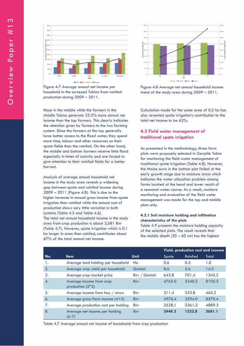
those in the middle while the farmers in the middle Tabias generate 25.5% more annual net income than the top farmers. This clearly indicates the attention given by farmers to the two farming system. Since the farmers at the top generally have better access to the flood water, they spend more time, labour and other resources on their spate fields than the rainfed. On the other hand, the middle and bottom farmers receive little flood especially in times of scarcity and are forced to give attention to their rainfed fields for a better harvest.
Analysis of average annual household net income in the study area reveals a widening gap between spate and rainfed income during 2009 – 2011 (Figure 4.8). This is due to the higher increase in annual gross income from spate irrigation than rainfed while the annual cost of production shows very little variation in both systems (Table 4.5 and Table 4.6). The total net annual household income in the study area from crop production is about 3,681 Birr (Table 4.7). However, spate irrigation which is 0.1 ha larger in area than rainfed, contributes about 67% of the total annual net income.
Calculation made for the same area of 0.5 ha has also revealed spate irrigation’s contribution to the total net income to be 62%.
4.2 Field water management of traditional spate irrigation
As presented in the methodology, three farm plots were purposely selected in Gerjalle Tabia for monitoring the field water management of traditional spate irrigation (Table 4.8). However, the Maize sown in the bottom plot failed at the early growth stage due to moisture stress which indicates the water allocation problem among farms located at the head and lower reach of a seasonal water course. As a result, moisture monitoring and evaluation of the field water management was made for the top and middle plots only.
4.2.1 Soil moisture holding and infiltration characteristics of the plotsTable 4.9 presents the moisture holding capacity of the selected plots. The result reveals that the middle depth (30 – 60 cm) has the highest
Figure 4.7 Average annual net income per household in the surveyed Tabias from rainfed production during 2009 – 2011.
Figure 4.8 Average net annual household income trend of the study area during 2009 – 2011.
Yield, production cost and income
No. Item Unit Spate Rainfed Total1. Average land holding per household Ha 0.6 0.5 1.02. Average crop yield per household Quintal 8.6 5.6 14.23. Average crop market price Birr / Quintal 643.8 701.4 1345.24. Average income from crop
production (2*3)Birr 4765.0 3340.3 8105.2
5. Average income from hay / straw Birr 211.4 253.8 465.26. Average gross farm income (4+5) Birr 4976.4 3594.0 8570.47. Average production cost per holding Birr 2528.1 2361.2 4889.38. Average net income per holding
(6-7)Birr 2448.3 1232.8 3681.1
Table 4.7 Average annual net income of households from crop production
Ove
rvie
w P
ap
er
#1
3

available moisture (RAM) would have been 142 mm. At a daily withdrawal of 4.64 mm, this RAM could have supplied the Sorghum sufficient moisture for 31 days.
The infiltration rate of the soil is very high and can have a positive role in facilitating the storage of the flood water in the soil profile. Figure 4.9 presents the infiltration rate and cumulative infiltration of the study area based on double ring infiltrometer test. The final infiltration rate, usually known as basic infiltration rate, was found to be 1.2 mm/min (72 mm/hr).
The infiltration equation of the soil developed based on the Kostiakov (1932) relationship is presented below.
moisture holding capacity in all plots. The total available moisture (TAM) of all the plots is very high and commensurate with the soil nature of the Raya Valley, which is Alluvial deposition. As indicated in Chapter 1, flood in Raya Valley does not occur frequently and the effective use of this scarce resource whenever it occurs is key for improved crop production.
The moisture holding capacity of the soil of the area provides an ideal opportunity to realize this target through spate irrigation. The moisture stored in the root zone of crops from a single flood could satisfy the water demand of crops for a long period. For example, the daily crop water requirement of Sorghum in the middle plot in 2011 during mid season stage was 4.64 mm/d (Table 4.14). Let’s assume that the total available moisture of 283.9 mm (Table 4.9) was stored in this plot from a single flood at the beginning of this growth stage. Since the depletion level allowed for Sorghum during this stage is 50%, the readily
Location Size (ha) Crop type Planting date H a r v e s t i n g date
Yield
Qt/plot
Qt / ha
Top 0.25 Teff 15/06/2011 17/10/2011 4.5 18.0Middle 0.50 Sorghum 25/05/2011 05/11/2011 14.0 28.0Bottom2 0.05 Maize 17/07/2011 - - -
Table 4.8 Description of the selected plots in Gerjalle Tabia
2) Note: The crop failed at early growth stage due to shortage of moisture
Plot location Moisture Content
Depth (cm)
Saturation (wt)
FC (wt) PWP (wt) BD (gm/cc)
TAM (% vol)
TAM (mm/m)
Top 0-30 0.364 0.316 0.077 1.13 27.05 81.130-60 0.344 0.312 0.086 1.23 27.78 83.460-100 0.342 0.303 0.116 1.33 24.73 98.9
Total 263.4
Middle 0-30 0.352 0.315 0.063 1.13 28.49 85.530-60 0.332 0.313 0.065 1.23 30.55 91.760-100 0.337 0.313 0.112 1.33 26.68 106.7
Total 283.9
Bottom 0-30 0.343 0.320 0.088 1.13 26.08 78.230-60 0.330 0.316 0.097 1.24 27.05 81.160-100 0.330 0.302 0.120 1.33 24.35 97.4
Total 256.8
Table 4.9 Moisture holding characteristics of the selected plots determined in laboratory
Sp
ate
Irriga
tion S
yste
ms in Ra
ya V
alley, Ethio
pia

F = 6.35*T00.678
Where:• F = Cumulative infiltration during opportunity
time (mm)• TO = Intake opportunity time (min)• 6.35 and 0.678 = Empirical constants
The constants were determined directly from the graph of the cumulative infiltration (F) and intake opportunity time (TO) plotted on a log-log scale (R2 = 0.996) (Figure 4.10).
4.2.2 Evaluation of field water management in the plotsField water management in the top plotAs it can be seen in Table 4.8, Teff was sown on 15 June 2011 in the top plot.
The crop water requirement of Teff calculated using the CROPWAT 8 software is given in Table 4.10. The actual daily soil moisture available at various depths and locations of the plot was determined based on the pressure readings of the Watermark (Annex V). Table 4.11 presents a general guideline about what Watermark readings mean in terms of soil moisture availability and irrigation (Thomson, S. J. and Armstrong C. F., 1987).
Soil moisture potential monitoring using the Watermark was carried out between 06 September 2011 and 12 October 2011. The pressure monitoring was terminated on 12 October 2011, because the Watermark reading in the plot reached 199 Centibar, which is the maximum limit.
Figure 4.9 Infiltration rate and cumulative infiltration of the study area.
Figure 4.10 Cumulative infiltration of the test over time on log-log scale.
Month Decade Stage Kc ETc (mm/day)
ETc (mm/dec)
Eff. Rain (mm/dec)
Irr. Req. (mm/dec)
Jun. 2 Init 0.30 1.73 10.4 0 10.4Jun. 3 Init 0.30 1.67 16.7 0 16.7Jul. 1 Dev 0.36 1.90 19.0 0 19.0Jul. 2 Dev 0.60 3.10 31.0 0 31.0Jul. 3 Dev 0.88 4.39 48.3 0 48.3Aug. 1 Mid 1.08 5.24 52.4 0 52.4Aug. 2 Mid 1.09 5.11 51.1 0 51.1Aug. 3 Mid 1.09 5.01 55.2 0 55.2Sep. 1 Mid 1.09 4.91 49.1 0 49.1Sep. 2 Mid 1.09 4.81 48.1 0 48.1Sep. 3 Mid 1.09 4.87 48.7 0 48.7Oct. 1 Late 1.02 4.61 46.1 0 46.1Oct. 2 Late 0.82 3.76 37.6 0 37.6Oct. 3 Late 0.62 2.78 30.6 0 30.6Nov. 1 Late 0.41 1.83 18.3 0 18.3Nov. 2 Late 0.30 1.32 1.3 0 1.3Total 564.0 0 564.0
Table 4.10 Crop water requirement of teff during the 2011 production season
Ove
rvie
w P
ap
er
#1
3

Referring to Table 4.11, it can be concluded that the top 30 cm soil was moisture deficient for most of the observation period than the lower depths. Since the root zone depth of Teff ranges between 30 and 60 cm during its growing period, this will definitely have a negative implication on moisture availability and ultimately yield.
On the other hand, the soil moisture tension of the bottom 60 – 100 cm soil was below 20 Centibar for 23 days within the observation period implying an adequately wet soil. Unfortunately, this water is stored beyond the depth Teff is capable of extracting.
Figure 4.11 and Annex V give only the tension at which the water is held within the soil. This has, however, to be converted to the corresponding available soil moisture depth so that whether water requirement of crops is satisfied or not can be easily determined (Table 4.10). The soil moisture characteristics curve developed based on laboratory analysis showed a high correlation (R2 = 0.995) between the soil moisture tension and available soil moisture content (Figure 4.12).
This correlation equation presented below was used to convert the daily Watermark pressure reading to actual daily moisture depth.
Figure 4.11 presents the average soil pressure reading of the Watermark at the three depths during the observation period while the daily readings are given in Annex V. Since some time is required for the Watermark to properly interact with the soil moisture movement around it and provide correct data, readings of the first few days were excluded from the analysis.
The result clearly reveals an inverse relationship between soil depth and soil moisture tension. The soil moisture tension decreases with depth at any given date during the entire observation period indicating better moisture availability at lower depths. This could be attributed to the high infiltration rate of the soil (72 mm/hr) that encourages the quick downward movement of the water in the soil profile. On the other hand, the soil moisture tension has shown an increase over the observation period in all depth profiles indicating the decrease in the amount of moisture available to crops.
Out of the total 33 days of observation period, the average soil moisture tension reading of 18, 1 and 0 days were in the range of 50 – 200 Centibar at 0 – 30 cm, 30 – 60 cm and 60 – 100 cm soil depths of the top plot respectively (Table 4.12).
Soil Moisture Tension (Centibar)
Implication
0-10 Saturated soil10-20 Soil is adequately wet, except coarse sands which begin to lose water20-50 Irrigation advised for most soils, except for heavy clay soil50-100 Irrigation advised for heavy clay soil100-200 Soil dangerously dry for a good production
Table 4.11 Relationship between Watermark pressure reading and soil moisture.
Figure 4.11 Average soil moisture tension reading by the Watermark at various depths of the top plot
Table 4.12 Average soil moisture tension distribution of the various depths in the top plot.
Number of occurrence during the observation period (Days)
Soil Moisture Tension (Centibar)
0-30 cm
30-60 cm
60-100cm
0-10 0 0 210-20 4 13 2120-50 11 19 1050-100 11 1 0100-200 7 0 0Total 33 33 33
Sp
ate
Irriga
tion S
yste
ms in Ra
ya V
alley, Ethio
pia

VSMT = 0.41 * e-Eqn. 4.1
where:• VSMT = Volumetric soil moisture content in the
top plot• P = Soil moisture tension (Bar)
The actual average daily available soil moisture of the top plot at various depths calculated using the above equation is presented in Annex VI while Figure 4.13 and Figure 4.14 give the daily available moisture for the depths of 0 – 60 cm and 60 – 100 cm respectively.
The water held in the soil at tensions lower than 0.33 Bar (FC) is termed as freely draining or gravitational water. The pressure is not high enough to hold the water within the soil and drains downward by gravitational force. As a result, the soil moisture stored in the root zone of Teff during 10 – 24 September 2011 was not as such beneficial (Figure 4.13).
On the other hand, the water held in the soil between tensions of 0.33 and 15 Bar is termed as total available moisture for plants (TAM). However, the soil moisture available between 0.33 and 1Bar pressure accounts about 50% of the total available moisture and is the part that
can easily be extracted by crops. The soil moisture situation in the root zone of Teff during 24 September – 12 October 2011 was, therefore, ideal for proper growth and development.
Figure 4.14 presents the soil moisture content of the top plot between the depths of 60 cm and 100 cm. However, this water is available beyond the root zone of Teff and will have no contribution to its productivity. It rather indicates the unnecessary loss of the scarce water in the top plot which could have been used to supply the moisture need of downstream farms.
Table 4.13 presents a summary of the water demand of Teff at 5 days interval and the corresponding moisture available in its root zone over the observation period. In addition, it also provides the actual soil moisture available beyond the root zone to indicate the inefficient water utilization.
The moisture available in the 60 – 100 cm soil profile is simply a loss as it cannot be extracted by Teff. This clearly indicates the unwise utilization of the scarce water resource. While crops in farms at the lower reach are failing due to insufficient moisture, a huge amount of non-productive water is stored in the top plots.
Considering the root zone of Teff (0 – 60 cm), the data shows that there was more than required available soil moisture during the observation period. As a result, the yield of Teff from the 0.25 ha plot was 4.5 quintal which would mean 18 quintal/ha (Table 4.8). This yield is by far higher than the average yield recorded in the study area (Table 4.3).
Last but not least, Table 4.13 has clearly revealed the inefficient use of flood water in the top plots. While the water demand of Teff at any given time is not more than 25 mm, the corresponding moisture available within its root zone is in excess of 200 mm. It has to be noted that this monitoring
Figure 4.12 Soil moisture characteristics curve of the top plot.
Figure 4.13 Actual average daily available soil moisture of the top plot between 0 – 60 cm depth
Figure 4.14 Actual average daily available soil moisture of the top plot between 0 – 60 cm depth
Ove
rvie
w P
ap
er
#1
3

Soil moisture potential monitoring using the Watermark was carried out between 06 September 2011 and 09 November 2011 (Annex VII). The pressure monitoring was terminated on 09 November 2011 because the Watermark reading in the plot reached 199 Centibar, which is the maximum limit.
Figure 4.15 presents the average soil pressure reading of the Watermark at the three depths during the observation period. The soil pressure reading trend of the middle plot is similar to the situation in the top plot, i.e., the soil moisture tension decreases with depth at any given date during the entire observation period and the soil moisture tension has shown an increase over the observation period in all depth profiles.
Figure 4.15 and Annex VII give only the tension at which the water is held within the soil. This was converted to the corresponding available soil moisture depth using the soil moisture characteristics curve developed for the plot. The curve of the middle plot showed a little higher correlation (R2 = 0.999) between the soil moisture tension and available soil moisture content than the top plot (Figure 4.16). This correlation equation presented below was used to convert the daily Watermark pressure reading to actual daily moisture depth. The equations of both plots were comparable indicating the relative uniformity of the soil types in the Raya Valley.
result was obtained during the mid season and late season stage of Teff which corresponds to a higher water demand. The water use efficiency would even be much worse if this situation occurs during initial and crop development stages where the root zone is shallow and the crop factor (Kc) is small. This demands the need for revising the flood water supply with respect to the crop type and growth stage.
Field water management of the middle plotSorghum was sown on 25 May 2011 in the middle plot (Table 4.8). The crop water requirement of Sorghum calculated using the CROPWAT 8 software is given in Table 4.14.
Date Water Demand
Actual available moisture (mm/depth)
0-60 cm 60-100 cm12-sept 24.4 243.0 162.617-sept 24.1 242.0 161.822-sept 24.2 240.2 162.027-sept 24.4 238.1 161.72-oct 23.8 235.5 161.47-oct 23.0 231.2 161.112-oct 21.3 226.6 160.6
Table 4.13 Water demand and supply of Teff at 5 days interval during the moisture monitoring period in 2011
Month Decade Stage Kc ETc (mm/day)
ETc (mm/dec)
Eff. Rain (mm/dec)
Irr. Req. (mm/dec)
May 3 Init 0.30 1.69 11.8 0 11.8Jun 1 Init 0.30 1.71 17.1 0 17.1Jun. 2 Dev 0.34 1.97 19.7 0 19.7Jun. 3 Dev 0.49 2.73 27.3 0 27.3Jul. 1 Dev 0.36 3.44 34.4 0 34.4Jul. 2 Mid 0.60 4.10 41.0 0 41.0Jul. 3 Mid 0.88 4.74 52.1 0 52.1Aug. 1 Mid 1.08 4.78 47.8 0 47.8Aug. 2 Mid 1.09 4.64 46.4 0 46.4Aug. 3 Mid 1.09 4.55 50.2 0 50.2Sep. 1 Mid 1.09 4.46 44.6 0 44.6Sep. 2 Late 1.09 4.31 43.1 0 43.1Sep. 3 Late 1.09 3.88 38.8 0 38.8Oct. 1 Late 1.02 3.35 33.5 0 33.5Oct. 2 Late 0.82 2.82 28.2 0 28.2Oct. 3 Late 0.62 2.47 2.5 0 2,5Total 538.2 0 538.2
Table 4.14 Crop water requirement of Sorghum during the 2011 production season
Sp
ate
Irriga
tion S
yste
ms in Ra
ya V
alley, Ethio
pia

VSMM = 0.411 * e Eqn. 4.2
where:• VSMM = Volumetric soil moisture content in the
middle plot• P = Soil moisture tension (Bar)
The actual average daily available soil moisture of the middle plot at various depths calculated using the above equation is presented in Annex VIII. Unlike in case of the top plot Teff, Figure 4.17 shows the daily available moisture of Sorghum for the entire depth of 100 cm.
This is because of the fact that Sorghum has a root zone of up to 140 cm at full growth and is capable of using water stored at higher depths. The Figure clearly shows the impact of crop root depth on improving the water use efficiency in spate irrigation. As it can be seen in Figure 4.14, the moisture stored in the 60 – 100 cm soil depth of the top plot was a total loss. In addition, Figure 4.13 also shows a higher amount of gravitational water in the top plot than the middle due to the unnecessary excess application.
On the other hand, the fraction of gravitational water in the middle plot is very little which shows a better water use efficiency than the top plots (Figure 4.17). This could be attributed to two facts. On one hand, Sorghum has a better capacity to extract water from deeper soil profile than Teff. On the other, the plots in the middle are not as susceptible to excess water application as the top plots. The latter can be explained by the higher soil moisture tension in Sorghum than in Teff.
Table 4.15 presents a summary of the water demand of Sorghum at 5 days interval and the corresponding moisture available in its root zone over the observation period. The result clearly indicates that the moisture available in this plot is very small compared to the amount in the top plot during the same period (Figure 4.18).
The result reveals that the available moisture in the top plot has been almost three times of the middle plot during the monitoring period. This clearly shows the unfair distribution of water among plots located at the top, middle and bottom of a scheme. This would obviously explain why the Maize in the bottom plot has failed during its initial growth stage.
Figure 4.15 Average soil moisture tension reading by the Watermark at various depths of the middle plot.
Figure 4.16 Soil moisture characteristics curve of the middle plot.
Figure 4.17 Actual average daily available soil moisture of the middle plot in the 100 cm depth
Figure 4.18 Actual moisture available in the top and middle plots over the same period
Ove
rvie
w P
ap
er
#1
3

and modern practices, the problems also vary accordingly.
Traditional systemsTraditional spate irrigation is the diversion of spate to farm lands using local materials available in the localities, mainly using shrubs, for agricultural food production. The design concept is to divert small part of the flood at a time in a place with a high possible expectation of damage to the diversion headwork and readiness to maintain, the damage occurred in the head work, during the recession phase of the flood, in order to utilize the flood water during the recession time. The principle is to divert the flood at different locations starting from the foothills of the mountains that is upstream of the river course to the place where the flood is abandoned far downstream. In principle, the practice is similar to the modern irrigation system considering the main river course as the main irrigation canal and the headworks similar to the division boxes. The important feature of this system is considered as one time serving headwork structure.
Modern systemsModern spate irrigation is the diversion of spate to farm lands using robust structures, mainly cement masonry and/or concrete structures. The design concept is to divert significant amount of the flood, the amount varies through experience and practice, at a point to serve a large command area. It is similar with the conventional river diversion headwork (constructed in streams with relatively free of sediments).
4.3 Comparative evaluation of the performance of traditional and modern spate diversion structures
4.3.1 Description of the traditional and modern systemsSpate irrigation can be defined as the utilization of spate/flood water occurring during the rainy season through irrigation for agricultural practices. Though there is no exact documentation about it, spate irrigation has been practiced for centuries in Raya valley. The practice has been significantly suffering mainly due to technical issues during diverting and distributing the flood water. However, the techniques and conceptual diversion mechanisms are different in both the traditional
Date Water Demand (mm)
Actual available moisture (mm/m)
11-sept 22.1 135.016-sept 21.5 134.721-sept 21.1 134.426-sept 19.4 134.11-oct 18.9 133.56-oct 16.8 132.711-oct 16.2 131.616-oct 14.1 130.3
Table 4.15 Water demand and supply of Sorghum at 5 days interval during the moisture monitoring period in 2011
Figure 4.19 Typical diversion headworks (a) Modern diversion headwork (b) Traditional spate diversion headworks (four diversion headworks from a river)
a b
Sp
ate
Irriga
tion S
yste
ms in Ra
ya V
alley, Ethio
pia

The design and construction of this practice is realized in this region for the first time in Hara, Raya valley named as Hara diversion headwork. The construction is completed in 2000. The modern system came to practice with an intention of improving the traditional diversion method, primarily by improving the serving life of the headwork, which is recognized as a shortcoming by all stakeholders. Hence, the important feature of this type of headwork is considered as a long lasting headwork with minor maintenance after rainy season, unlike the traditional practice. 4.3.2 Comparative assessment of the advantages and disadvantages of the two systems
Advantages of traditional spate systemsAnderson (2007) has indicated that while traditional spate irrigation structures seem crude, they have enabled irrigation to be sustained for many years using only local materials and indigenous skills. Their very best advantage is their flexibility. Rivers in spate lift and deposit huge quantities of sediment. As a result, there is a change in bed levels, both in the river system and in the distribution network which results in frequent changes and adjustments of the system (Mehari et.al 2010). As the Wadi conditions change frequently, the traditional headwork structures can easily cope up with the changes either by moving upwards and/or removing the headwork structures. These traditional schemes best serve when they are placed along a bridge or culvert structures as these structures help in stabilizing the Wadi bed. An example is the Harosha traditional spate system which is located at an immediate downstream of a bridge (Figure 4.20). The second advantage is that they experience lesser conflicts between upstream and downstream users because they enable equitable sharing of water at many diversion points. They are relatively
efficient in diverting the flood using many diversion points. As far as the diversion efficiency with respect to the whole discharge along the Wadi is concerned, they are by far better than the modern one. The third advantage is related to their ability in avoiding sedimentation in cases of large floods (Anderson, 2007) as the headwork structure is breached during higher flood. Higher floods carry higher sediment loads and create considerable damage to the command area and canal structures. Finally, these structures require low initial investment costs.
Disadvantages of traditional spate systemsWhile the traditional spate systems are endowed with the aforementioned benefits, they also have some drawbacks. They utilize excessive labor for their operation and maintenance. As these structures are easily damaged by flood, a stand-by and enormous labor is needed to maintain and reconstruct the structures almost after every flood. Secondly, they have a negative environmental impact in aggravating land degradation since their construction requires the cutting of woods, bushes and shrubs. Thirdly, since they are limited to lower head diversions, it is almost impossible to construct them in deeper Wadis (Figure 4.21).
Advantages of modern spate systemsThe advantages of the modern spate irrigation can be categorized in to four. Firstly, they are designed and constructed to permanently serve for about 25 years. Secondly, even if they are not effective in irrigating their intended design capacity, they are very helpful in stabilizing the Wadi level which sustains the life of traditional systems at upstream of the modern spate structures. Thirdly, though susceptible to sedimentation of the off-take and canal structures, they enable the diversion of higher discharges (very large floods) at a time. Fourthly, they have lower operational cost as compared to the
Figure 4.20 The Harosha traditional spate system having many diversion points along the Wadi at an immediate downstream of a bridge
Ove
rvie
w P
ap
er
#1
3

systems. As a result, sediments are usually not dredged timely causing the systems to irrigate smaller area than their designed capacity. In addition, the diversion of very large floods also causes considerable damage to the command area and canal structures. The modern spate systems also require high initial investment cost and highly skilled manpower for their design and construction. Last but not least, if they are damaged, their maintenance demands longer time as well as huge labour and finance.
4.3.3 Why are traditional systems performing better?The most important factor that has contributed to the better performance of traditional spate systems in Raya Valley is the tremendous practical knowledge and skill accumulated by farmers as a result of centuries old fight to harness the flood and use it for productive purposes. This exercise has enabled the farmers to seek solutions to properly manage the flood and subsequently achieve more success than the modern spate systems. This can be witnessed by the failure of about 13 of the 17 modern systems constructed in Raya Valley.
traditional ones as the modern structures avoid the periodic and yearly maintenance cost of the headwork and canal structures that can easily be damaged by flood. The last and very best advantage is their ability to easily divert flood in deeper rivers. An example is the Dayu spate irrigation system (Figure 4.22).
Disadvantages of modern spate systemsAccording to IFAD (2005), not all modern irrigation is an improvement over indigenous systems. Sometimes, especially when farmers’ views are not fully considered, the construction of modern engineered systems can worsen the operations for those farmers involved. The first demerit is that modern spate systems divert all ranges of floods including the larger ones which carry very high sediment loads. Lawrence (2008) has indicated that sediment concentrations rising to and exceeding 100,000 ppm or 10% by weight occur in floods in some Wadis and sediment concentration up to 5% by weight are common. The diversion of these higher sediment loads generally make the life of the farmers difficult in which they have to dredge huge sediment volumes both at the off-take and canal
Figure 4.21 Traditional diversion canal at downstream of Dayu spate scheme left over because of Wadi bed level lowering
Figure 4.22 The Dayu spate system before and after modernized spate headwork structure construction
Sp
ate
Irriga
tion S
yste
ms in Ra
ya V
alley, Ethio
pia
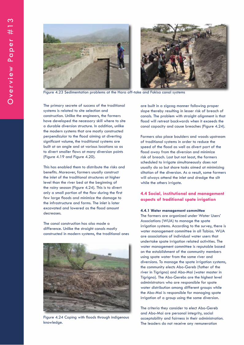
The primary secrete of success of the traditional systems is related to site selection and construction. Unlike the engineers, the farmers have developed the necessary skill where to site a durable diversion structure. In addition, unlike the modern systems that are mostly constructed perpendicular to the flood aiming at diverting significant volume, the traditional systems are built at an angle and at various locations so as to divert smaller flows at many diversion points (Figure 4.19 and Figure 4.20).
This has enabled them to distribute the risks and benefits. Moreover, farmers usually construct the inlet of the traditional structures at higher level than the river bed at the beginning of the rainy season (Figure 4.24). This is to divert only a small portion of the flow during the first few large floods and minimize the damage to the infrastructure and farms. The inlet is later excavated and lowered as the flood amount decreases.
The canal construction has also made a difference. Unlike the straight canals mostly constructed in modern systems, the traditional ones
are built in a zigzag manner following proper slope thereby resulting in lesser risk of breach of canals. The problem with straight alignment is that flood will retreat backwards when it exceeds the canal capacity and cause breaches (Figure 4.24).
Farmers also place boulders and woods upstream of traditional systems in order to reduce the speed of the flood as well as divert part of the flood away from the diversion and minimize risk of breach. Last but not least, the farmers scheduled to irrigate simultaneously does not usually do so but share tasks aimed at minimizing siltation of the diversion. As a result, some farmers will always attend the inlet and dredge the silt while the others irrigate.
4.4 Social, institutional and management aspects of traditional spate irrigation
4.4.1 Water management committeeThe farmers are organized under Water Users’ Associations (WUA) to manage the spate irrigation systems. According to the survey, there is water management committee in all Tabias. WUA are associations of individual water users that undertake spate irrigation related activities. The water management committee is reputable based on the establishment of the community members using spate water from the same river and diversions. To manage the spate irrigation systems, the community elects Abo-Gereb (father of the river in Tigrigna) and Abo-Mai (water master in Tigrigna). The Abo-Gerebs are the highest level administrators who are responsible for spate water distribution among different groups while the Abo-Mai is responsible for managing spate irrigation of a group using the same diversion.
The criteria they consider to elect Abo-Gereb and Abo-Mai are personal integrity, social acceptability and fairness in their administration. The leaders do not receive any remuneration
Figure 4.23 Sedimentation problems at the Hara off-take and Fokisa canal systems
Figure 4.24 Coping with floods through indigenous knowledge.
Ove
rvie
w P
ap
er
#1
3
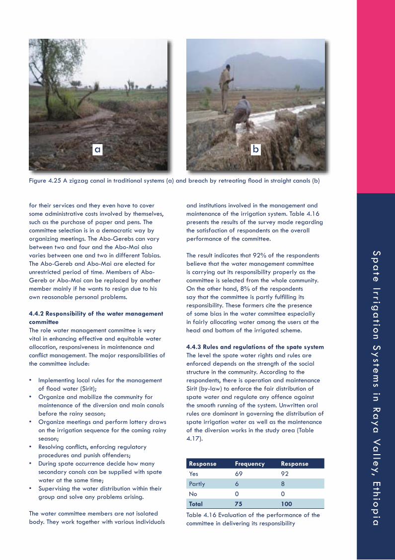
and institutions involved in the management and maintenance of the irrigation system. Table 4.16 presents the results of the survey made regarding the satisfaction of respondents on the overall performance of the committee.
The result indicates that 92% of the respondents believe that the water management committee is carrying out its responsibility properly as the committee is selected from the whole community. On the other hand, 8% of the respondents say that the committee is partly fulfilling its responsibility. These farmers cite the presence of some bias in the water committee especially in fairly allocating water among the users at the head and bottom of the irrigated scheme.
4.4.3 Rules and regulations of the spate systemThe level the spate water rights and rules are enforced depends on the strength of the social structure in the community. According to the respondents, there is operation and maintenance Sirit (by-law) to enforce the fair distribution of spate water and regulate any offence against the smooth running of the system. Unwritten oral rules are dominant in governing the distribution of spate irrigation water as well as the maintenance of the diversion works in the study area (Table 4.17).
for their services and they even have to cover some administrative costs involved by themselves, such as the purchase of paper and pens. The committee selection is in a democratic way by organizing meetings. The Abo-Gerebs can vary between two and four and the Abo-Mai also varies between one and two in different Tabias. The Abo-Gereb and Abo-Mai are elected for unrestricted period of time. Members of Abo-Gereb or Abo-Mai can be replaced by another member mainly if he wants to resign due to his own reasonable personal problems.
4.4.2 Responsibility of the water management committeeThe role water management committee is very vital in enhancing effective and equitable water allocation, responsiveness in maintenance and conflict management. The major responsibilities of the committee include:
• Implementing local rules for the management of flood water (Sirit);
• Organize and mobilize the community for maintenance of the diversion and main canals before the rainy season;
• Organize meetings and perform lottery draws on the irrigation sequence for the coming rainy season;
• Resolving conflicts, enforcing regulatory procedures and punish offenders;
• During spate occurrence decide how many secondary canals can be supplied with spate water at the same time;
• Supervising the water distribution within their group and solve any problems arising.
The water committee members are not isolated body. They work together with various individuals
Figure 4.25 A zigzag canal in traditional systems (a) and breach by retreating flood in straight canals (b)
a b
Response Frequency Response
Yes 69 92Partly 6 8No 0 0Total 75 100
Table 4.16 Evaluation of the performance of the committee in delivering its responsibility
Sp
ate
Irriga
tion S
yste
ms in Ra
ya V
alley, Ethio
pia

As it can be seen in Table 4.17, 48% of the respondents confirm the presence of Sirit in a written form in their area while the 52% indicate the existence Sirit in an oral form. The latter farmers also indicate that the oral form rules are based on common understanding and are subject to variation of judgement of individuals. According to the water committee members, the Sirit (by law) comprises a comprehensive set of rules covering all aspects of interest of the water users. They also confirmed that the majority of the farmers act according to the Sirit and offenders are penalized. The rules for operation and water management were formulated by the communities.
According to the discussion held with water committee members, the community used to have a written Sirit decade back by a local land lord called Hajji Yasin who owned most of the land under the spate irrigation system. This Sirit is still used by the community even after the modernization of the spate irrigation system. The written Sirit clearly defines each farmer’s right and duties which contribute towards involving every user willingly. The major elements of the Sirit low of the study area are presented below.
• A member who does not participate in silt removing shall pay 20 birr per day;
• A member who does not participate in gabion box filling shall pay 25 birr per day;
• A member who provokes a quarrel during spate water distribution shall be fined 18 birr;
• A member who insults Abo-Gerebs or Abo-Mais shall be fined 50 birr;
• A person proved to have stolen water by breaking canal out of his turn and deprived other entitled persons of their share shall pay 200 birr;
• After irrigating his land if a farmer does not close his field canals and let other people close the canals for him he will be fine 50 birr;
• A member who reveals a secret spoken in the WUA shall be fined 18 birr;
• A member who failed to pay his fines and relieve the person who bailed him shall be excluded from the association;
• A member who repeatedly failed to participate in construction and maintenance of
irrigation infrastructures and provoked quarrel shall be excluded from the association;
• A member penalized for violating the Sirit and complain his case to local Sheik or Priest shall be excluded from the association;
• Members who did not get a single spate water the previous rainy season gets priority in the next season;
• Money collected in the WUA will be used to procure materials relevant for the spate irrigation system.
Beneficiaries need to have their own say in the preparation, implementation and evaluation of the Sirit to be implemented in their areas. Respect the committee, desist from conflict instigating activities and show their respect to their community members by paying what they are penalized and freeing the person who bailed them. The level of participation of the community is presented in Table 4.18.
92% of the respondents rate the participation of the community in the formulation and implementation of the Sirit as high and argue that this has guaranteed the effectiveness and sustainability of the system. On the other hand, 8% of the respondents see the community participation as medium.
As women and other disadvantaged groups such as elders and disabled are part of the community, they also participate in the formulation and implementation of the Sirit. The Sirit also includes article(s) to guarantee the proper and full participation in the development and management as well as benefit sharing of women and other disadvantaged groups such as elderly people. Participation of woman and other disadvantaged groups in the formulation and implementation of the Sirit is presented in Table 4.19. According to the collected feedback, 24%, 36% and 40% of the respondents believe that the participation of women and other disadvantaged groups in the formulation and implementation of the Sirit as high, medium and low respectively. This clearly indicates that more needs to be done to practically ensure the involvement of these groups as depicted in the Sirit.
Response Frequency Response
Written 36 48Oral 39 52Total 75 100
Table 4.17 Forms of spate irrigation Sirit in the Raya Valley
Response Frequency Response
High 69 92Medium 6 8Low 0 0Total 75 100
Table 4.18 Participation of the community in the formulation and implementation of the Sirit.
Ove
rvie
w P
ap
er
#1
3
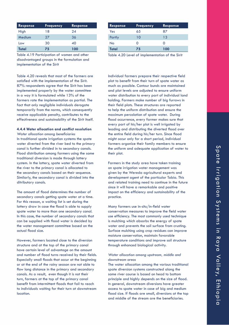
Individual farmers prepare their respective field plot to benefit from their turn of spate water as much as possible. Contour bunds are maintained and plot levels are adjusted to ensure uniform water distribution to every part of individual land holding. Farmers make number of big furrows in their field plots. These structures are reported to help the uniform distribution and ensure the maximum percolation of spate water. During flood occurrence, every farmer makes sure that every part of his/her plot is well irrigated by leading and distributing the diverted flood over the entire field during his/her turn. Since flood might occur only for a short period, individual farmers organize their family members to ensure the uniform and adequate application of water to their plot.
Farmers in the study area have taken training on spate irrigation water management was given by the Wereda agricultural experts and development agent of the particular Tabia. This and related training need to continue in the future since it will have a remarkable and positive impact on the efficiency and sustainability of the practice.
Many farmers use in-situ/in-field water conservation measures to improve the field water use efficiency. The most commonly used technique is mulching which absorbs the energy of spate water and prevents the soil surface from crusting. Surface mulching using crop residues can improve moisture conservation, maintain favorable temperature conditions and improve soil structure through enhanced biological activity.
Water allocation among upstream, middle and downstream areasThe water allocation among the various traditional spate diversion systems constructed along the same river course is based on head to bottom principle and highly depends on the size of flood. In general, downstream diversions have greater access to spate water in case of big and medium flood size. If floods are small, diversions at the top and middle of the stream are the beneficiaries.
Table 4.20 reveals that most of the farmers are satisfied with the implementation of the Sirit. 87% respondents agree that the Sirit has been implemented properly by the water committee in a way it is formulated while 13% of the farmers rate the implementation as partial. The fact that only negligible individuals derogate temporarily from the norms, which consequently receive applicable penalty, contributes to the effectiveness and sustainability of the Sirit itself.
4.4.4 Water allocation and conflict resolutionWater allocation among beneficiariesIn traditional spate irrigation systems the spate water diverted from the river bed to the primary canal is further divided in to secondary canals. Flood distribution among farmers using the same traditional diversion is made through lottery system. In the lottery, spate water diverted from the river to the primary canal is allocated to the secondary canals based on their sequence. Similarly, the secondary canal is divided into the ditributary canals.
The amount of flood determines the number of secondary canals getting spate water at a time. For this reason, a waiting list is set during the lottery draw in case the flood is able to supply spate water to more than one secondary canal. In this case, the number of secondary canals that can be supplied with flood water is decided by the water management committee based on the actual flood size.
However, farmers located close to the diversion structure and at the top of the primary canal have certain level of advantage on the amount and number of flood turns received by their fields. Especially small floods that occur at the beginning or at the end of the rainy season are not able to flow long distance in the primary and secondary canals. As a result, even though it is not their turn, farmers at the top of the primary canal benefit from intermittent floods that fail to reach to individuals waiting for their turn at downstream location.
Response Frequency Response
High 18 24Medium 27 36Low 30 40Total 75 100
Table 4.19 Participation of women and other disadvantaged groups in the formulation and implementation of the Sirit
Table 4.20 Level of implementation of the Sirit
Response Frequency Response
Yes 65 87Partly 10 13No 0 0Total 75 100
Sp
ate
Irriga
tion S
yste
ms in Ra
ya V
alley, Ethio
pia

The upstream farmers have through the years learned that timely and properly maintained diversion and always allow irrigating their fields with small floods. During the large floods, however, the water has to pass through their fields on its way to the downstream areas. This approach has paved the way for confidence building among the farmers.
Conflict resolution in spate irrigationThere is low level of water allocation conflict both among beneficiaries using the same traditional spate diversion system and between the upstream, middle and downstream users along the river for three main reasons.
Primarily, the lottery system of water allocation among farmers using the same diversion is very democratic. Secondly, the upstream, middle and downstream users believe that the upstream spate users have the right to divert the flood water because it is the first to be irrigated as the sequence water allocation before the middle and downstream. Third, the farmers at the top usually use almost all of the small floods while they let much of the big and medium floods to flow downstream areas.
This arrangement has contributed towards minimizing conflict among farmers over spate water use. The overall rating of conflict occurrence in the traditional spate system by the respondents is presented in Table 4.21.
According to the feedback from the farmers, 92% and 96% of the respondents believe that there is no conflict among beneficiaries using the same spate diversion and among the upstream, middle and downstream users respectively.
There are also different provisions made to resolve the conflicts both in the water allocation among beneficiaries using the same traditional spate diversion system and among the various traditional spate diversion systems. There are three identified ways of conflict resolution mechanisms as mentioned below:
• Individual discussion: Individuals discuss and agree on resolving the conflict;
• At group level: this is a semi-formal, since group leaders are elected among water committee based on the Sirit. Normally the group leader is well respected person for both parties and can give more trustful and appreciable judgment;
• Tabia administration and the community court (Mahberawi fird bet): the water users committee refers conflict management cases beyond its capacity to the Tabia administration and the community court.
As a result of the above facts, 92%, 4% and 4% of the respondents rate the distribution efficiency of spate water among individual farmers as good, medium and poor respectively (Table 4.22).
4.4.5 MaintenanceMaintenance and rehabilitation of spate irrigation systems is essential without which there will simply be no irrigation during the succeeding year or even within the same rainy season. The earthen structures built collectively are often washed away by severe floods and the farmers are required to collectively re-build them in order to capture next spate. The short and long term existence of the traditional spate irrigation depends on the contribution of members in operation and maintenance of the headwork. Timely maintenance of the head work before the rain season is the most essential for the sustainability of the system. This will contribute to the establishment of successful community based organizations that help the distribution of spate water.
Occurence of Conflict Total
Yes No
Water Allocation Conflict Freq % Freq % Freq %Conflict among beneficiaries using the
same spate diversion6 8 69 92 75 100
Conflict among the upstream, middle and downstream users
3 4 72 96 75 100
Table 4.21 Conflict occurrences over spate distribution among farmers
Response Frequency Response
Good 69 92Medium 3 4Poor 3 4Total 75 100
Table 4.22 Evaluation of the water distribution efficiency among individual farmers
Ove
rvie
w P
ap
er
#1
3

Women and other disadvantaged groups also contribute to the maintenance activities especially in the provision of local construction materials such as brushwood and tree branches.
The overall evaluation of maintenance of structures by the community is presented in Table 4.23. As it can be seen, 96% of the respondents agree that the status of maintenance of structures is good and the contribution of labour for construction and maintenance work do not depend on land holding size. On the other hand, 4% of the farmers believe that the status of maintenance is medium. In case of emergency such as damage to the headwork, damage to the conveyance and distribution networks, and when urgent maintenance is required before the arrival of another spate, every adult in the community regardless of family size is expected to mobilize to the maintenance work.
Table 4.24 presents the evaluation of the farmers about the sustainability of traditional spate irrigation system. 40% of the respondents say that the traditional spate diversion structures serve for one year with minor maintenance while 42% of them agree on the fact that they require major maintenance/reconstruction after the main rainy season only. Since traditional river diversions are generally constructed from local materials such as soil, bushes and stone bunds, their service life is one year.
Maintenance of spate irrigation structures that needs community level participation is organized by the water management committee. Water management committee mobilizes resources and fixes times of maintenance. Resources for maintenance include community labour, income from punishment and voluntary community contribution. The entire community members are required to contribute labour for the maintenance of the headwork and main canal. On the other hand, conveyance structures such as secondary and distrubutary canals that serve only to part of the command area are maintained by the individuals using them. Moreover, simple damages at the very vicinity (proximity) of an individual irrigator do not need organized action and are usually maintained respective famers. The sirit create a tight discipline in the preparation of local materials and labour contributions to the maintenance of the aforementioned structures.
The water management committees are responsible to set additional rules when needed and then the rules have to be approved by all farmers at system level. These rules include fines to be paid in cash if a farmer does not obey. The rules are best understood as norms and agreed sanctions. Actual punishment is often based on the judgment of the water management committee. Generally, the punishments for those who do not participate in maintenance include:
• First time, 20 – 50 Birr punishment or pay on the rate of daily labourer base;
• Second time, will be given spate water at the end;
• Repeated absence from maintenance may result in prohibition of access to water.
However, the fee collected from fines is usually used for purchase of drinks during social events of the community than for the maintenance of the traditional diversion structures.
Response Frequency Response
Good 72 96Medium 3 4Poor 0 0Total 75 100
Table 4.23 Status of maintenance of structures
Response Frequency Response
Serves for one year including the main rain season without any maintenance
13 18
Serves for one year with minor maintenance 30 40Serves for two years with minor maintenance 0 0Requires major maintenance/reconstruction after each rainy season only 0 0Requires major maintenance/reconstruction after the main rainy season only
32 42
Requires major maintenance/reconstruction after each flood 0 0Total 75 100
Table 4.24 Evaluation of the sustainability of the traditional spate irrigation diversion systems by the respondents.
Sp
ate
Irriga
tion S
yste
ms in Ra
ya V
alley, Ethio
pia

The diversion efficiency of the traditional spate is also evaluated by the farmers as presented in Table 4.25. The result indicates that 13%, 33% and 54% of the respondents believe that the diversion efficiency of the traditional spate irrigation system is 75 – 100%, 50 – 75% and 25 – 50% respectively. However, all of the respondents have pointed out that these traditional structures have enabled irrigation to be sustained for many years using only local materials and indigenous skills to divert flood water.
5. CONCLUSION AND RECOMMENDATION
5.1 ConclusionThe major crops of rainfed agriculture are Sorghum and Teff while Maize and Onion are additional crops cultivated in traditional spate irrigation in the study area. The study has revealed that the average yield of spate irrigation was always higher than rainfed as a result of the better moisture availability.
A high variation in yield has also been witnessed among various crops within the same production season. Onion and Teff have resulted in the highest and lowest average yield respectively during the three survey years (2009 – 2011). The market price of all crops has shown an increasing trend of varying degree over the years, the increase in market price between 2009 and 2011 ranging from 29% for Sorghum to 138% for Onion. The average annual household net income from both spate irrigation and rainfed production has increased during 2009 – 2011 as a result of increased market price of crops. The annual net income per household has increased from 1,414 Birr in 2009 to 3,717 Birr in 2011 for spate irrigation while the corresponding increase in rainfed was from 750 Birr to 1,742 Birr. The amount of average annual household net income was generally small due to the relatively high production cost and selection of crops. For example, the average annual production cost
of spate irrigation accounted about 63% and 41% of the gross income in 2009 and 2011 respectively while the corresponding cost in rainfed production was 75% and 58% of the gross income.
The crops grown were also dominantly cereals characterized by low yield and low market price. The contribution of spate irrigation to the total annual household net income was found to be 62% indicating its importance. Last but not least the relationship between production system, Tabia location and subsequently income was very interesting. The survey has revealed that Tabias located at the top of a river course received better flood supply, yield and income than those located at a lower reach in all years.
On the other hand, the rainfed yield and subsequent income of lower Tabias was higher than the top Tabias. The average household annual net income from spate irrigation of farmers in the top Tabias was 22% higher than those in the middle while the farmers in the middle Tabias generate 25.5% more annual net income than the top farmers.
This clearly indicates the attention given by farmers to the two farming system. Since the farmers at the top generally have better access to the flood water, they spend more time, labour and other resources on their spate fields than the rainfed. On the other hand, the middle and bottom farmers receive little flood especially in times of scarcity and are forced to give attention to their rainfed fields for a better harvest.
Three farm plots located at the top, middle and bottom of a seasonal river course were purposely selected for evaluating the field water management of traditional spate irrigation. Teff, Sorghum and Maize were sown at the top, middle and bottom plots respectively. The total available moisture (TAM) of the plots is very high (257 mm/m – 284 mm/m) and commensurate with the soil nature of the Raya Valley, which is Alluvial deposition.
Since flood in Raya Valley does not occur frequently, the effective use of this scarce resource whenever it occurs is key for improved crop production. The moisture holding capacity of the soil of the area provides an ideal opportunity to realize this target through spate irrigation. The moisture stored in the root zone of crops from a single flood could satisfy the water demand of crops for a long period. For instance, a single flood can supply Sorghum with sufficient moisture for 31 days during its peak water demand
Response Frequency Response
75-100% 10 1350-75% 25 33
25-50% 40 54Below 25% 0 0Total 75 100
Table 4.25 Diversion efficiency of the traditional spate irrigation system.
Ove
rvie
w P
ap
er
#1
3

water from deeper soil profile than Teff. On the other, the plots in the middle are not as susceptible to excess water application as the top plots. The latter can be explained by the higher soil moisture tension in Sorghum than in Teff. Generally, the moisture available in middle plot was very small compared to the amount in the top plot during the same period.
The result revealed that the available moisture in the top plot has been almost three times of the middle plot during the monitoring period. This clearly shows the unfair distribution of water among plots located at the top, middle and bottom of a scheme. This would obviously explain why the Maize in the bottom plot has failed during its initial growth stage.
The major source of this poor water allocation is the traditional spate irrigation management by-law (Sirit) that favours to farmers at the head end of a seasonal stream.
There are two types of spate diversion systems in Raya Valley, namely, traditional and modern systems. Traditional spate irrigation is the diversion of spate to farm lands using local materials available in the localities, mainly using shrubs, for agricultural food production.
The design concept is to divert small part of the flood at a time in a place with a high possible expectation of damage to the diversion headwork and readiness to maintain. On the other hand, modern spate irrigation is the diversion of spate to farm lands using robust structures, mainly cement masonry and/or concrete structures. The design concept is to divert significant amount of the flood, the amount varies through experience and practice, at a point to serve a large command area.
The study found out that about 13 of the 17 modern diversion systems constructed in Raya Valley had already failed during the survey. On the other hand, traditional spate diversions were found to perform better than the modern. The primary secrete of success of the traditional systems is related to site selection and construction. Unlike the engineers, the farmers have developed the necessary skill where to site a durable diversion structure.
In addition, unlike the modern systems that are mostly constructed perpendicular to the flood aiming at diverting significant volume, the traditional systems are built at an angle and at various locations so as to divert smaller flows at many diversion points. Moreover, farmers usually
growth stage. Soil moisture tension monitoring was made at three depths, namely, 0 – 30 cm, 30 – 60 cm and 60 – 100 cm.
The tension reading result of the Watermark clearly revealed an inverse relationship between soil depth and soil moisture tension. The soil moisture tension decreases with depth at any given date during the entire observation period indicating better moisture availability at lower depths. This could be attributed to the high infiltration rate of the soil (72 mm/hr) that encourages the quick downward movement of the water in the soil profile. The monitoring made in the top plot has revealed the inefficient use of flood water. While the root zone of Teff is 30 – 60 cm, there was about 160 mm of moisture available in the 60 – 100 cm soil profile during the monitoring period. This moisture was, however, simply a loss as it cannot be extracted by Teff.
This clearly indicates the unwise utilization of the scarce water resource. While crops in farms at the lower reach are failing due to insufficient moisture, a huge amount of non-productive water is stored in the top plots. For example, the Maize sown in the bottom plot failed at the early growth stage due to moisture stress which indicates the water allocation problem among farms located at the head and lower reach of a seasonal water course.
Even considering the root zone of Teff (0 – 60 cm), the result showed that there was more than required available soil moisture during the observation period. While the water demand of Teff at any given time was not more than 25 mm, the corresponding moisture available within its root zone was in excess of 200 mm. It has to be noted that this monitoring result was obtained during the mid season and late season stage of Teff which corresponds to a higher water demand. The water use efficiency would even be much worse if this situation occurs during initial and crop development stages where the root zone is shallow and the crop factor (Kc) is small.
This demands the need for revising the flood water supply with respect to the crop type and growth stage. The moisture monitoring in the middle plot has, on the other hand, indicated the impact of crop root zone and location on improving water use efficiency in spate irrigation.
The fraction of gravitational water in the middle plot was found to be very little compared to the top plot indicating a better water use efficiency. This could be attributed to two facts. On one hand, Sorghum has a better capacity to extract
Sp
ate
Irriga
tion S
yste
ms in Ra
ya V
alley, Ethio
pia

construct the inlet of the traditional structures at higher level than the river bed at the beginning of the rainy season and are lowered as the flood amount decreases.
The canal construction has also made a difference. Unlike the straight canals mostly constructed in modern systems, the traditional ones are built in a zigzag manner following proper slope thereby resulting in lesser risk of breach of canals. Farmers also place boulders and woods upstream of traditional systems in order to reduce the speed of the flood as well as divert part of the flood away from the diversion and minimize risk of breach.
Traditional spate irrigation operation and maintenance is led by a water management committee consisting of Abo-Gerebs and Abo-Mais. The Abo-Gerebs are the highest level administrators who are responsible for spate water distribution among different groups while the Abo-Mai is responsible for managing spate irrigation of a group using the same diversion. Both written and oral operation and maintenance Sirit (local by-law) is used in the management of spate irrigation systems. The participation of the community in the formulation and implementation of the Sirit was found to be high. In addition, the Sirit also includes article(s) to guarantee the proper and full participation in the development and management as well as benefit sharing of women and other disadvantaged groups such as elderly people. The level of implementation of the Sirit was also rated as 87%.
The water allocation among the various traditional spate diversion systems constructed along the same river course is based on head to bottom principle and highly depends on the size of flood. In general, downstream diversions have greater access to spate water in case of big and medium flood size. If floods are small, diversions at the top and middle of the stream are the beneficiaries. On the other hand, flood distribution among farmers using the same traditional diversion is made through lottery system. Water management committee mobilizes resources and fixes times of maintenance. Resources for maintenance include community labour, income from punishment and voluntary community contribution. The entire community members are required to contribute labour for the maintenance of the headwork and main canal.
On the other hand, conveyance structures such as secondary and distrubutary canals that serve only to part of the command area are maintained by the individuals using them. However, the fee
collected from fines is usually used for purchase of drinks during social events of the community than for the maintenance of the traditional diversion structures. The traditional spate diversion structures either serve for one year with minor maintenance or require major maintenance/reconstruction after the main rainy season.
5.2 Recommendation
Some of the most important recommendations relevant to the major findings of the study include:
• The present cereal based spate irrigation seems to have limited the income of the farmers due to lower yield and market price. Introduction of high yielding and high value crops need to be given due attention to make spate irrigation more profitable.
• The water allocation and field water management of the traditional spate irrigation is poor. Plots located at the top of a river course apply excess amount of water while those at the lower reach suffer from shortage. At present, most of the water applied in the top plots is lost as either deep percolation or evaporation. If water allocation and application is made based on crop type and growth stage, even a small flood can be sufficient to supply water to farms across a water course.
• Traditional spate diversion systems have already proved to perform better than the modern systems. However, traditional systems are also very susceptible to damage by flood. Improving the strength of the traditional systems by simple techniques such as gabions while keeping the benefits is very crucial.
• Improving the existing Sirit, its documentation and implementation capacity should be given the top priority. For instance, the most important improvement should be made is related to the principles of water allocation among farmers using different diversion structures along the same stream. Instead of the present flood amount based arrangement that favours to farmers at the head of a river course, allocation should be made based on the crop type and the amount of water that can be stored within the root zone per irrigation. The use of the fee collected from penalty for purchase of drinks for a social event is another simple amendment that could be made to the current trend. More importantly, though, is the formulation and implementation of a regional operation and maintenance rules and regulations of spate irrigation.
Ove
rvie
w P
ap
er
#1
3

6 REFERENCES
1. Alemehayu, Taye (2008). Spate Profile of Ethiopia (A Preliminary Assessment). Paper presented to FAO International Expert Consultation Workshop on Spate Irrigation, April 7 to 10 2008, Cairo, Egypt.
2. Anderson, I.M.A. (2008). Diversion and Control of Spate Flows for Irrigation: Spate irrigation summer course handbook.
3. Awulachew S. B., Yilma A. D., Loulseged M., Loiskandi, W., Ayana M., Alamirew T. (2007). Water Resources and Irrigation Development in Ethiopia. IWMI Working Paper No. 123. Colombo, Sri-Lanka.
4. Commission for Sustainable Agricultural and Environmental Rehabilitation in Tigray (1994). Sustainable Agriculture and Environmental Rehabilitation in Tigray: Basic Text. Mekelle, Tigray.
5. COTWRD (2005). Engineering Feasibility Report of Gereb Fokissa Spate Irrigation Project: Head Work and Infrastructure reports. Mekelle, Ethiopia.
6. Daily Ethiopia News (2010). Ethiopia Joins Middle Income Nations in 5 years. Internet site: http://www.dailyethiopia.com/index.php?aid=853. Visited on 18 October 2010.
7. Emergency Disaster Database (2004). Country Profile for Natural Disasters. http://www.em-dat.net. Visited on 05 October 2004.
8. Engida, M. (2000). Moisture Regimes of Ethiopia. Paper Presented at the Fourth Symposium on Sustainable Water Resources Development, 3 - 4 July 2000, Arba Minch Water Technology Institute, Arba Minch, Ethiopia. In Seleshi, B. et al. (eds.) (2001): Ethiopian Journal of Water Science and Technology (Vol. 4): Proceedings of the Fourth Symposium on Sustainable Water Resources Development. pp 19 – 22. Arba Minch, Ethiopia.
9. Eyasu, Y. (2005). Development and Management of Irrigated Lands in Tigray, Ethiopia. Taylor and Francis Group Plc. London, UK.
10. Food and Agriculture Organization/United Nation Development Program (1987). Spate irrigation. Proceedings of the sub regional expert consultation on wadi development for agriculture in the Natural Yemen, 6–10 December, 1987. Aden, PDR Yemen, New York and Rome.
11. Food and Agriculture Organization of the United Nations (2005). Irrigation in Africa in Figure. AQUASTAT Survey. Rome, Italy.
12. Food and Agriculture Organization of the United Nations (2010). Proceedings of the FAO Expert consultation on spate irrigation, Cairo, April 2008.
13. Haile Ghebremariam, Berhane and Frank van Steenbergen (2007). Agricultural WaterManagement in Ephemeral Rivers: Community Management in Spate Irrigation in Eritrea.
14. Haile, K. (2009). Community Spate Irrigation in Raya Valley: the case of three spate irrigation systems. MSc thesis, Addis Ababa University. Addis Ababa, Ethiopia.
15. Hailu, M. and Merga, S.N. (2001). Workshop on the experience of water harvesting in the drylands of Ethiopia: principles and practices. 28–30 December, 2001, Mekelle, Ethiopia. Drylands Co-ordination Group.
16. Hehmeyer, I. (2000). The spirit of cooperation in Yemeni agricultural practices successful cases from the past, and their applicability for the present. Proceedings of conference: The Place of Ancient Agricultural Practices and Techniques in Yemen Today: Problems and Perspectives. Sana’a, Yemen, 18–20 June, 2000. Available at: http:// www.aiys.org/webdate/pelheh.html
17. International Commission on Irrigation and Drainage (2010). ICID multilingual technical dictionary on irrigation and drainage. Revised edition, New Delhi.
18. IFAD (2005). Ethiopia: Enhancing food security through small scale irrigation. Number 35, http://www.ifad.org/evaluation/public_html/eksyst/doc/profile/pf/ethiopia.htm
19. Kostiakov, A.N. (1932). The Dynamics of the Coefficient of Water Percolation in Soils. ISSS. pp 17 – 21.
20. Lawrence, Philip and Frank van Steenbergen (2004). Community spate irrigation guidelines. Wallingford: HR Wallingford.
21. Lawrence, Philips (2008). Managing Sedimentation in Spate Irrigation Schemes: Spate Irrigation Summer course Hand Book.
22. Mehari, Abraham Haile (2007). A tradition in transition. Water Management Reforms and Indigenous Spate Irrigation Systems in Eritrea. Delft: UNESCO-IHE.
23. Mehari, A., Van Steenbergen, F. and Schulz, B. (2010). Modernization of Spate Irrigated Agriculture: A New Approach, Irrigation and Drainage DOI: 10.1002/ird.565.
Sp
ate
Irriga
tion S
yste
ms in Ra
ya V
alley, Ethio
pia

24. Ministry of Water Resources (2010). Irrigation and Drainage Projects in Ethiopia. http://www.mowr.gov.et/index.php?pagenum=4.2&pagehgt=1000px. Visited on 18 October 2010.
25. Moustafa, A.T.A., El-Meligy, A.A. and Allam, M.A.A. (1987). Spate irrigation in Egypt. In: Spate Irrigation: proceedings of the Sub-Regional Expert Consultation on Wadi Development for Agriculture in the Natural Yemen, Aden, December 1987. FAO/UNDP.
26. Nawaz, K. (2002). Spate irrigation systems in Pakistan – An alternative to present crises (draft). Pakistan, Pakistan Agricultural Research Council (PARC).
27. Nawaz, K. (2003).Spate irrigation in Dera Khazi Khan, Pakistan. Available at: http:// www.spate-irrigation.org.
28. Teka, Danile, Tesfa-alem G/Egziabher, Woldemariam G/Hiwot, Alemseged Mekonnen (2004). Monitoring and Evaluation of Spate Irrigation in Tigray. Mekelle: Tigray Water Resources Development Commission.
29. Thomson, S.J. and Armstrong C.F. (1987). Calibration of the Watermark model 200 soil moisture sensor. Appl. Eng. Agric. 3:186-189.
30. Van Mazijk, R. and Scheer, S. (1988). Irrigatie in Tunesie, een overheidsinterventie in een traditioneel irrigatiesysteem beschouwd vanuit ee interfaceperspectief, Wageningen, LUW.
31. Van Steenbergen, F.O. Verheyen, S. van Aarst and Mehari, A. (2008). Spate irrigation, livelihood improvement and adaptation to climate variability and change. IFAD/ MetaMeta/UNESCO-IHE.
32. Van Steenbergen, Frank, Philip Lawrence, Abraham Haile Mehari, Maher Salman and Jean-Marc Faurès (2010). Guidelines on Spate Irrigation. Rome: FAO.
33. Ward, C., Ueda, S. and McPhail, A. (2000). Water resources management in Yemen.Contribution to the CDR Yemen. Draft: 20 January 2000. 39 pp.
34. Water Works Design and Supervision Enterprise (2008). Raya Pressurized Irrigation Project: Water Resources and Hydro-Meteorology Feasibility Study. Ministry of Water Resources, Addis Ababa, Ethiopia.
35. Water Works Design and Supervision Enterprise (2008). Raya Pressurized Irrigation Project: Socio-economic Feasibility Study. Ministry of Water Resources, Addis Ababa, Ethiopia.
36. Water Works Design and Supervision Enterprise (2008). Raya Pressurized Irrigation Project: Environmental Impact Assessment Feasibility Study. Ministry of Water Resources, Addis Ababa, Ethiopia.
37. Webb P. and Braun J. V. (1994). Famine and Food Security in Ethiopia: Lessons for Africa. John Wiley and Sons Ltd. Chichetser, England.
Ove
rvie
w P
ap
er
#1
3
ColofonThis paper was prepared by Eyasu Yazew (Mekelle University), Temesgen Gebru (Mekelle University), Tesfa-alem G/Egziabher (Mekelle University), Atinkut Mezgebu (Mekelle University), Degol Fessehaye (Mekelle University), Solomon Habtu (Mekelle University), Abraham Haile (Tigray Bureau of Water Resources), Frank van Steenbergen (MetaMeta) and Flip Wester (Wageningen University Research).
The research team would like to forward its appreciation to NUFFIC for the financial support and Mekelle University and Tigray Bureau of Water Resources for their commitment and follow-up. We also thank Mrs. Graas and UNESCO-IHE for their role in facilitating the funds for the research. Our heartfelt thanks also goes to Hirut for her consistent, unreserved and effective follow-up, organization and promotion of our work. Last but not least, we also acknowledge the Alamata Wereda Office of Agriculture and Rural Development, Agamte Tabia administration, local farmers and experts for their assistance.
The Spate Irrigation Network supports and promotes appropriate programmes and policies in spate irrigation, exchanges information on the improvement of livelihoods through a range of interventions, assists in educational development and supports in the implementation and start-up of projects in Spate irrigation. For more information: www.spate-irrigation.org.
Sp
ate
Irriga
tion S
yste
ms in Ra
ya V
alley, Ethio
pia