Space Technology development in Vietnam 2015-2016...
38
Space Technology development in Vietnam 2015-2016 Assoc.Prof. Dr. Doan Minh Chung, Chairman, National Research Program on Space Science & Technology Vietnam Academy of Science and Technology (VAST)
Transcript of Space Technology development in Vietnam 2015-2016...
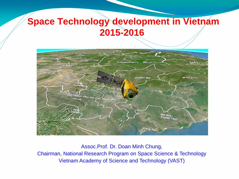
Space Technology development in Vietnam 2015-2016
Assoc.Prof. Dr. Doan Minh Chung, Chairman, National Research Program on Space Science & Technology
Vietnam Academy of Science and Technology (VAST)

2
SPACE TECHNOLOGY INFRASTRUCTURE DEVELOPMENT OF VIETNAM UNTIL 2020
1. Develop & launch some communication satellites:- 2008: VINASAT-1 with 12 transponders;- 2012: VINASAT-2 with 24 transponders.
2. Develop & launch some EO satellites:- 2013: VNREDSat-1 optical 130 kgs; 2.5m PAN, 10m MS- 2018: JVLOTUS-1 radar 500kgs- 2020: JVLOTUS-2 radar 500kgsPlanning VNREDSat-2 (optical; 1m) & VNREDSat-2B (hyperspectral)
3. Project “Vietnam Space Center” - Japan ODA- Build Space Center (Hoa Lac high tech. Park)- Develop & launch JVLOTUS-1; -2 radar

3
Project Owner: VASTPrime contractor: EADS AstriumLaunch time: 07/5/2013 at Kourou, France
VNREDSat-1(VietNam small satellite for natural Resource, Environment
& Disaster management)
Mission: Earth observation in PAN and 4 MS spectral bandsRevisit time: 3 daysOrbit characteristics: SSO, 680 km altitudeLTAN : 10:42 PMSpatial resolution: 2.5m (PAN) and 10m (MS)Platform: 600 mm x 570 mm x 500 mmTotal mass: ~130kgLife-time: 5 years (guaranteed) Imaging modes: single shot, scanning, stereoSwath : 17.5 kmStrip length: 823 km (PAN + MS)Number of acquired images per day: 100 scenes Agility : +/- 35 degrees

Architecture of the VNREDSat-1 system

Acquired Images
5
VNREDSat-1 images over ASEAN
As of 31th August 2016, VNREDSat-1 satellite has captured and downlinked:
• In total: more than 54.000 scenes

VNREDSat-1 satellite has captured and downlinked:
• In Vietnam: more than 29.000scenes

Vietnam Space Center - VAST
7
Ha Noi
Nha Trang
Ho Chi Minh City
Vietnam Space Center in HHTP
Nha Trang ObservatorySpace Application Center in Ho Chi Minh City
Center of Human Resource Development in
Space Technology
Fund: Japanese ODA & Vietnam; Duration: 2012 – 2021; Exe. Agency: VNSC

Plan for EO satellite development of VNSC until 2020
NanoDragon
PicoDragon
LOTUSat-2
MicroDragon
8

National Research Program on Space S&T - VAST
- 26 Projects approved in the period 2012-2015Budget ~ 104 bil.VND ~ 5 mil.USD- 22 projects started in 2016 & 2017 with budget ~ 7 mil.USD
Small satellite, GNSS, GRS technologies. Applications of RS,GIS,GPS and communication satellite for
economic development; natural resource, environment and disaster management, transportation, sea navigation;
Fabrication space technology equipments such as MW radiometers, optical payloads, spectroscopy on UAV, atmospheric sensors on balloons, nano satellite, GPS high resolution receiver, mobile receiving station for communication satellite, etc.
Fundamental research for space technology applications (medical-biology in space; material science in space environment).
Launcher rocket technique.

Design and manufacture of the GPS high resolution receiving station
(NAVIS, HN Univ.) - 2013-2016
10/10/16 10

Testing and potential applications of NAVIS's GPS receiving station
10/10/16 11

VNSC – simulation of the satellite posture system – ADCS2012-2016
Introduction to Satellite Technology
12
(2008-2011)
(2014 -2015)

DESIGN AND MANUFACTURING A MODEL ELECTRO-OPTICAL PAYLOAD FOR MULTISPECTRAL IMAGER FOR SMALL EO SATELLITE
(2013-2016)

INVESTIGATION, DESIGN AND FABRICATION OF AUTOMATIC CONTROLSYSTEMS IN SATELLITE RECEIVER INTERGRATEDWITH LOW-FIELD MAGNETIC SENSORS BASED ON MAGNETOELECTRICEFFECT (2008-2011)
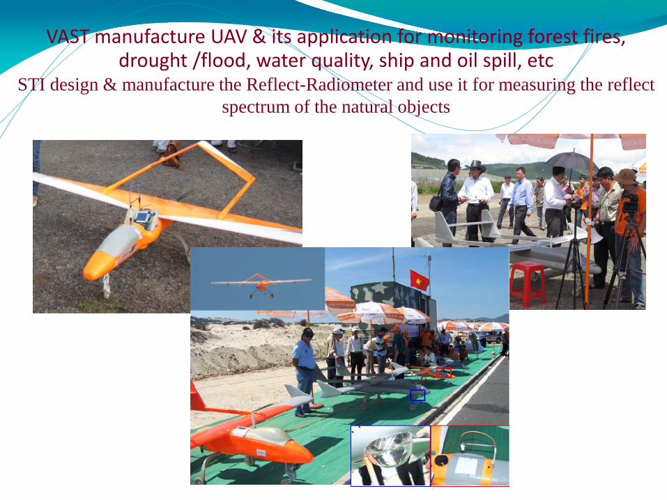
VAST manufacture UAV & its application for monitoring forest fires, drought /flood, water quality, ship and oil spill, etc
STI design & manufacture the Reflect-Radiometer and use it for measuring the reflect spectrum of the natural objects

Applications of VNREDSat-1 for disaster management - landslides

Applications of RS&GIS for estimation of the geological hazards (landslides) in highland

Establish the spectral library for natural objects of Vietnam using spectroscopy on UAV - 2014

Applications of RS&GIS for coffee monitoring of growing status, prediction of its yield & production, pilot in DakLak - 2013-2016

Project “Research of methodology for estimation and monitoring the coastal water quality of Vietnam using high, everage, multi-temporal satellite data, trial utilization with VNREDSat-1 data –VT/CB-01/14-15
Map of SPM distribution of River Hong zone (25/9/2014)
Map of SPM distribution of HaLong bay zone (25/9/2014)
Main electronic Portral of the water quality of coastal zone of Vietnam

Thiết kế và chế tạo tổ hợp tên lửa thử nghiệm TV-01 mô phỏng tên lửa đẩy tầm thấp (2013-2015)
Độ cao bay tối đa
≥ 4000 m
Cự ly bay tối đa
≥ 3000 m
Tốc độ tối đa
≥ 200 m/s
Tải có ích (hộp vệ
tinh)≥ 3 kg
Số lượng tầng 02
Phương pháp
phóngthẳng đứng
Hệ thống điều khiển
ô-tô-nôm
Loại động cơ
nhiên liệu rắnSơ đồ bay Sơ đồ phối trí tên lửa
Bảng thông số cơ bản
Presenter
Presentation Notes
Bệ phóng cho phép gá lắp và phóng tên lửa theo phương thẳng đứng nhiều lần. Hệ thống theo dõi bắn – bay bao gồm hệ thống viễn trắc và hệ thống quan sát quang-điện tử bám theo tên lửa. Tên lửa được phóng thẳng đứng và ổn định đạt đến độ cao H~550m (t~7s) thì được điều khiển để thực hiện bẻ nghiêng quỹ đạo từ từ đạt góc 700. Khi tên lửa đạt đến độ cao H~2200m (t~12s) thì cắt động cơ tầng 1, khởi động động cơ tầng 2. Tên lửa tiếp tục bay đến độ cao H~4200 (t~22s), bán kính theo phương ngang X~1200m) thì cắt động cơ tầng 2 và bung dù, tách “hộp vệ tinh”. “Hộp vệ tinh” tiếp tục bay theo quán tính và được thu hồi bằng dù.

TEST THE PV-01 AT THE TRIAL AREA (2013-2016)
Ợ

Design and manufacture 3 passive microwave radiometers (L, C, X bands).
Utilizations of MW radiometers and passive MWRS methods to determine SMC, biomass, SST, SSS, etc.
Conduct and promote Space education for junior students and children (water rocket, space poster competitions, etc.)
L band microwave Radiometer
Software for RDM data receiving and processing
Data process in the Microwave Laboratory
To measure soil moisture content (SMC) on crop fields
To determine biomass on corn field
Passive MW RS on soil moisture, vegetation, sea surface temperature & salinity

Ứng dụng các hệ Phổ kế SCT nghiên cứu độ mặn (SSS) và nhiệt độ mặt nước biển (SST)
Cán bộ Viện Tài nguyên & Môi trường Biển, VAST tham gia đo
độ mặn nước biển.

Assembly Radiometers on helicopter
Registered TB over rice field in 60 minutes
Aerial remote sing for soil moisture mapping
Aerial Remote Sensing for soil moisture mapping

International cooperation for disaster management in Vietnam
(through UNESCAP – STI (VAST) – DMC (MARD)
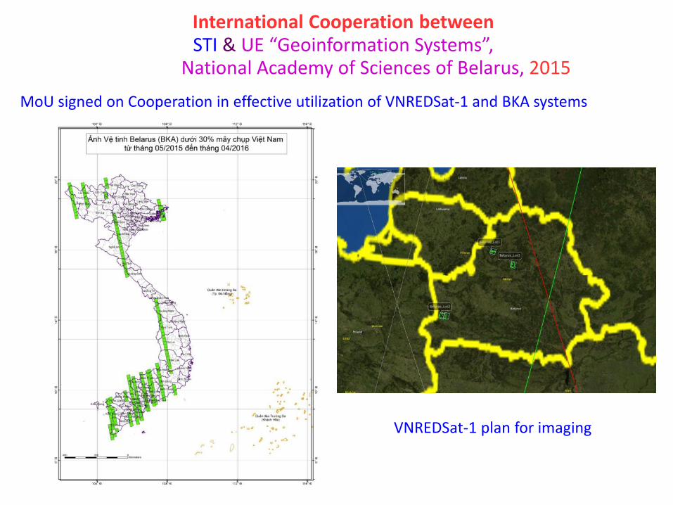
International Cooperation betweenSTI & UE “Geoinformation Systems”,
National Academy of Sciences of Belarus, 2015
MoU signed on Cooperation in effective utilization of VNREDSat-1 and BKA systems
VNREDSat-1 plan for imaging

BKAs’ image: Tan Son Nhat Airport

Cooperation with JAXA for disaster managementKick-off workshop on utilization of remote sensing & GIS for disaster management –
Sentinel Asia Mini-project – 10/2014 (JAXA-AIT-STI-DMC)
- JAXA: Dr. Naoto Matsuura- DMC: Dr. Hoang Van Thang – Dir. Water Management Dept., Vice-Minister MARD
- VAST/STI: Vice-Presedent of VAST
will sign MOU for cooperation.

STI: VNREDSat-1 as a SA-DPN- Vietnam is a member of UNESCAP since 23/8/1954 18/11/2015: VNREDSat-1/STI accepted as a SA-DPN/DAN
No. Area Disaster Date of imageDate of request Requester
1 Souther Luzon andå Vasasy, Philippines Typhoon 17/12/2015 15/12/2015ESCAP
2 Tamil Nadu, India Flood 3/12/2015 2/12/2015SA
3 Kathmandu, Nepal Earthquake 4/5/2015 27/04/2015ESCAP
4 Gandaki, Nepal Earthquake 1/5/2015 27/04/2015ESCAP
5 Vanuatu, Australia Cyclone 18/03/2015 16/03/2015ESCAP
6 Tacloban, Philippine Typhoon 10/12/2014 9/12/2014SA
7 Vishakhapatnam, India Cyclone 15/10/2014 13/10/2014ESCAP
8 Srinagar, India Flood 18/09/2014 15/09/2014ESCAP
9 Muzzaffargarh, Pakistan Flood 18/09/2014 15/09/2014ESCAP
10 Ludian, China Earthquake 8/8/2014 6/8/2014ESCAP
11 MH370 Missing 11/3/2014 10/3/2014GISTDA
12 Jakarta, Indonesia Flood 16/01/2014 15/01/2014SA
Total scenes received: 283 scenes
GISTDA: Geo-Informatics and Space Technology Development Agency, Thailand

VNREDSat-1 responses to Sentinel Asia in 2016
STT Date Disasters Location
1 08/11/2015 Heavy rain, Flood Tamil Nadu, India
2 14/12/2015 Melor Storm Southern of Luzon, Philippines
3 06/02/2016 Earthquake Taiwan
4 22/02/2016 Typhoon Fiji Island, Pacific Ocean
5 25/02/2016 Glacier melt Northern of Myanmar
6 01/03/2016 Flood Northern of Myanmar
7 02/03/2016 Flood Jakarta, Indonesia
8 14/03/2016 Flood Bandung, Indonesia
9 01/04/2016 Forest fire Philippines
10 01/04/2016 Oil Spill Taiwan
11 06/04/2016 Land slide Pakistan
12 14/04/2016 Earthquake Myanmar
13 16/04/2016 Earthquake Japan
14 16/04/2016 Earthquake Ecuador
15 16/05/2016 Flood SriLanKa
16 23/05/2016 Vocalno eruption (Sinabung) Indonesia
17 20/06/2016 Land slide Indonesia
Total scenes received: 330 scenes

Image over Tacloban, Philippines, 15th Nov 2013
32
Srinagar_India
Muzaffargarh_Pakistan
Flood areas on 18th Sep 2014
International cooperation of VNREDSat-1 image for disaster management

“HUDHUD” cyclones, VNREDSat-1 image in 23/10/2014, causing mud flooding in Visakhapatnam, India

Image VNREDSat-1 captured flooding, landslides of Philippines (Typhoon Hagupit - N.5 (07/12/2014)
Tacloban_10122014 Leyte_10122014
Leyte_10122014Tacloban_10122014

VNREDSat-1 captured forest fires at Pateros, Washington, USA - 27/08/2015
© VAST

VNREDSat-1 image over Tamil Nadu, India (3/12/2015) –Emergency Observation request by SA dated 2/12/2015
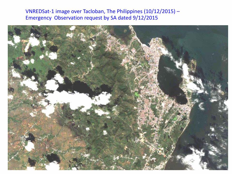
VNREDSat-1 image over Tacloban, The Philippines (10/12/2015) –Emergency Observation request by SA dated 9/12/2015