Southeast Coastal Ocean Observing Regional Association...
20
1 Southeast Coastal Ocean Observing Regional Association (SECOORA): A Framework for Monitoring, Prediction and Assessment to Support Decision-Makers Needs for Coastal and Ocean Data and Tools Program Performance Report Award Number: NA11NOS012003 Reporting Period: 1 June 2015 – 30 November 2015 Date submitted: 11 December 2015 Principal Investigator: Associate Investigator: Debra Hernandez, Executive Director Dr. Conrad C. Lautenbacher, Jr., SECOORA Board Chair SECOORA GeoOptics PO Box 13856 Dunwoody, GA Charleston, SC 29422 P: (770) 730-5911 P: 843-906-8686 E: [email protected] E: [email protected] Associate Investigator: Associate Investigator: Megan Lee, Business Manager Vembu Subramanian, RCOOS Manager SECOORA SECOORA PO Box 13856 PO Box 13856 Charleston, SC 29422 Charleston, SC 29422 P: 843-864-6755 P: 727-525-1926 E: [email protected] E: [email protected] Project Summary Southeast Coastal Ocean Observing Regional Association (SECOORA) and its members are integrating and augmenting existing observational, modeling, data management and education assets in the southeastern US domain to create an end-to-end Regional Coastal Ocean Observing System (RCOOS) in support of user-defined needs for improved coastal and ocean decision making. With this grant funding SECOORA is: 1. Sustaining SECOORA as a Regional Information Coordination Entity (RICE). This will ensure that stakeholder needs are met through assessment and governance mechanisms that effectively prioritize the distribution of RCOOS-related funding, and coordination of projects and other resources that are required to meet critical regional needs; 2. Sustaining and expanding a coastal and ocean observing subsystem for the Southeast that provides coordinated monitoring, assessment and prediction, and includes moored and coastal stations, high frequency radars (HFR), gliders and storm event monitoring subcomponents; 3. Supporting a multi-scale modeling subsystem that includes regional ocean, shelf and estuarine circulation (nowcast/forecast); estuarine and surge/inundation prediction (nowcast/forecast); and other user-defined modeling needs; and which uses the observing subsystem for verification, validation, assimilation, and operation; 4. Supporting the Data Management and Communication (DMAC) subsystem to optimize operations, facilitate technology evolution / transfer, and address structural / project management complexities; and 5. Supporting an education and outreach subsystem partnered with other RAs and marine education efforts that engages diverse education and stakeholder audiences to understand the benefits of ocean observing to society.
Transcript of Southeast Coastal Ocean Observing Regional Association...

1
Southeast Coastal Ocean Observing Regional Association (SECOORA): A Framework for Monitoring, Prediction and Assessment to
Support Decision-Makers Needs for Coastal and Ocean Data and Tools Program Performance Report
Award Number: NA11NOS012003 Reporting Period: 1 June 2015 – 30 November 2015
Date submitted: 11 December 2015
Principal Investigator: Associate Investigator: Debra Hernandez, Executive Director Dr. Conrad C. Lautenbacher, Jr., SECOORA Board Chair SECOORA GeoOptics PO Box 13856 Dunwoody, GA Charleston, SC 29422 P: (770) 730-5911 P: 843-906-8686 E: [email protected] E: [email protected]
Associate Investigator: Associate Investigator: Megan Lee, Business Manager Vembu Subramanian, RCOOS Manager SECOORA SECOORA PO Box 13856 PO Box 13856 Charleston, SC 29422 Charleston, SC 29422 P: 843-864-6755 P: 727-525-1926 E: [email protected] E: [email protected]
Project Summary
Southeast Coastal Ocean Observing Regional Association (SECOORA) and its members are integrating and augmenting existing observational, modeling, data management and education assets in the southeastern US domain to create an end-to-end Regional Coastal Ocean Observing System (RCOOS) in support of user-defined needs for improved coastal and ocean decision making. With this grant funding SECOORA is:
1. Sustaining SECOORA as a Regional Information Coordination Entity (RICE). This will ensure that stakeholder needs are met through assessment and governance mechanisms that effectively prioritize the distribution of RCOOS-related funding, and coordination of projects and other resources that are required to meet critical regional needs;
2. Sustaining and expanding a coastal and ocean observing subsystem for the Southeast that provides coordinated monitoring, assessment and prediction, and includes moored and coastal stations, high frequency radars (HFR), gliders and storm event monitoring subcomponents;
3. Supporting a multi-scale modeling subsystem that includes regional ocean, shelf and estuarine circulation (nowcast/forecast); estuarine and surge/inundation prediction (nowcast/forecast); and other user-defined modeling needs; and which uses the observing subsystem for verification, validation, assimilation, and operation;
4. Supporting the Data Management and Communication (DMAC) subsystem to optimize operations, facilitate technology evolution / transfer, and address structural / project management complexities; and
5. Supporting an education and outreach subsystem partnered with other RAs and marine education efforts that engages diverse education and stakeholder audiences to understand the benefits of ocean observing to society.

2
Progress and Accomplishments
During this reporting period, SECOORA submitted the revised scope of work for Year 5 (June 1, 2015 – May 31, 2016). Contractual review and account establishment for the Year 5 award were completed, and funding for SECOORA sub-awards were disbursed to partner institutions. The administration of the Year 4 and 5 sub-awards are being continued by SECOORA. As per the U.S. IOOS Year 5 award letter, SECOORA committed: (1) no less than $600,000 towards supporting priority High Frequency Radars, (2) $20,000 for maintenance of the high frequency radar site located at Core Banks, NC, (3) $10,000 to University of South Florida to support ship-time for SECOORA internship activities, (4) $7000 to support IOOS Advisory Committee travel, (5) $108,015 to support water sampling and Gray’s Reef buoy maintenance in conjunction with NOAA’s Ocean Acidification Program, and $5000 for a Southeast Ocean and Coastal Acidification Network (SOCAN) engagement workshop, and (6) $30,000 to support the continued curation of IOOS open source repositories with special focus on system integration test products. We also submitted a proposal, titled “Southeast Coastal Ocean Observing Regional Association (SECOORA): Supporting Resilient Ecosystems, Communities and Economies” in response to the US Integrated Ocean Observing System (IOOS) FY 2016 Federal Funding opportunity. This report details the progress and accomplishments over the reporting period.
Goal 1: Sustain SECOORA as a Regional Information Coordination Entity (RICE)
Milestones: Progress continues on this goal, and brief milestone updates are provided below. Additional details are described in the table that follows.
A. Provide timely grant reports to NOAA: During this reporting period, submitted IOOS Semi-annual progress reports, NOPP annual report, and the semi-annual Federal Financial report.
B. Hold Board Meeting Fall 2015 and Members Meeting 2016: Held Fall 2015 Board meeting in Charleston, SC (Dec. 3-4, 2015). Planning for Spring 2016 (Raleigh, NC, May 18-20, 2016) Board and Annual Members meetings are underway.
C. Publish e-newsletters and other outreach material: We continued to engage in marketing and outreach activities via e-newsletter, e-mails, social media (Facebook and Twitter) and website. During this reporting period, SECOORA sent 1 e-newsletter, 1 holiday email, and 2 2016 Annual Meeting save the date emails to our email listserv, referring a combined 131sessions to our website through our e-outreach. We sent 5 emails outlining staff updates to the Board and produced 13 stories highlighting staff, members’ and PIs’ work. SECOORA newsletters, stories and videos were published on our website. We continue to engage in outreach and education events as well as provide materials to RCOOS PIs, Board and Members who attend science meetings, provide information to governmental representatives, etc. SECOORA staff and members engaged in over 44 in-person and conference call outreach events. SECOORA and the NOAA Ocean Acidification Program co-hosted the Southeast Ocean and Coastal Acidification Network (SOCAN) state of the science webinar series on ocean acidification to support and encourage discussions on ocean and coastal acidification in the Southeast region. We have sent 24 SOCAN webinar e-newsletters to the 200 people subscribed to the SOCAN listserv, referring 187 sessions to our website. We, together with IOOS Association and other RAs provided congressional outreach support on Integrated Coastal Ocean Observing System (ICOOS) Act reauthorization activities.
D. Coordinate with neighboring RAs: We continue to work closely with the neighboring Regional Associations and state and federal government agencies to ensure that messages, products, and projects are coordinated and resources are leveraged.

3
E. SECOORA website updates focused on data portal expansion, and PI project news: Ongoing. F. Work with IOOS Association and U.S. IOOS Program Office to effectively respond to NOAA
and other National level requirements: Debra Hernandez, Vembu Subramanian, Megan Lee and Abbey Wakely continued to attend the monthly IOOS Association calls. Debra, Vice-chair of IOOS Association (IA) Board, attended the IA ExCom calls. Debra traveled to DC (July 7 – 9, 2015) with other Regional Association Directors and Josie Quintrell (IOOS Association) to provide information to congressional members, staff and others (Joshua Gross (Representative Duncan- SC); Yates Branch (Senator Isakson- GA); Reese Pelley (Senator Graham- SC); Jennifer Nawrocki (Representative Jolly- FL); Spensor Penderson (Representative Scott- SC); Kyle Sanders (Representative Rouzer- NC); Gerald Huang (Representative Perdue- GA); and Beth Kerttula National Ocean Council Director, Council on Environmental Quality (CEQ), Executive Office of the President (EOP)) on the ICOOS Reauthorization Bill. Debra also attended the Senate Oceans Caucus Briefing, “Why Ocean Observing Matters” on July 9 in DC. Debra joined Josie Quintrell (IA), Ru Morrison (NERACOOS), Molly McCammon (AOOS), and Carl Gouldman (IOOS PO) in Chicago for an IOOS strategic planning session (August 4 – 5, 2015). Debra Hernandez, Conrad C. Lautenbacher, Vembu Subramanian and Abbey Wakely attended the IOOS Association annual meeting (September 14-16, 2015) held in St. Petersburg. Bill Hogarth, SECOORA Board Vice-Chair, was a guest speaker at the meeting. SECOORA, with GCOOS, sponsored an IOOS community social on September 15, 2015. Over 50 IOOS friends were in attendance. Debra attended the National Estuarine Research Reserve System (NERRS) science collaborative advisory board meeting held in Portland, OR (November 12, 2015). Vembu Subramanian attended the monthly IOOS RA DMAC calls. SECOORA staff continues to coordinate input on IOOS web site redesign, QARTOD manuals, animal telemetry network and the modeling strategy; and submitted comments as appropriate to the IA/IOOS program office.
G. Refine and maintain RCOOS Conceptual Operations Plan: We are in the process of developing Strategic Operational Plan as a part of the US IOOS Certification application that will cover the RCOOS operational plan. We will change this activity to “Refine and Maintain Strategic Operational Plan” for the next reporting period.
H. Support local, regional, and national collaboration: SECOORA staff and PIs regularly collaborate through co-sponsored meetings, participation in working groups and committees, and through coordination with regional and national colleagues. Some meetings and coordination activities include:
Southeast Ocean and Coastal Acidification Network (SOCAN) state-of-the-science webinar series on ocean acidification
Climate Variability and Fisheries Workshop (October 26-28, 2015)
Second Annual Integrated Tracking of Aquatic animals in the Gulf of Mexico (iTAG) workshop (Telemetry in the 21st Century: new methods and applications to fisheries management, October 29-30, 2015)
Connecting Indian River Lagoon (IRL) Data with Users (December 7-8, 2015)
SECOORA Fisheries Habitat Modeling - South Carolina Department of Natural Resources (SCDNR) and South Atlantic Fisheries Management Council (SAFMC)
IOOS DMAC and Website redesign efforts – SECOORA, IOOS and all other RAs
SECOORA in-situ data archival efforts – National Centers for Environmental Information (NCEI)
IOOS Association and congressional outreach efforts

4
HF Radar Steering Team (Nick Shay, University of Miami stepped down as a member of the committee in July 2015)
Modeling, Glider and Animal Telemetry Network strategies
Governors’ South Atlantic Alliance (GSAA)
Weather Ready Nation (WRN) Ambassador
NERRS – US IOOS Collaborative initiative
I. Evaluate mechanisms to track operational statistics, product usage, and outcome measures and metrics: Continue to track website usage with Google Analytics (GA). We periodically review the GA metrics and social media referrals to understand the end users behavior and time spent on sections of the website to implement improvements to the website. We are in the process of upgrading to Google Universal Analytics, agreed upon by all RAs and IOOS to collect common metrics (# of sessions on RA websites and # of visitors on RA websites). We are expected to complete the upgrade by mid-December 2015. SECOORA DMAC technical personnel have implemented alert services to track the data flow from data providers (observations and modeling subsystems).
SECOORA Activities Progress
Ensure continued and efficient Governance, Management and Operations of the RA.
Provide forums, i.e. workshops, meetings that enable stakeholder assessment and engagement.
Coordinate with the GSAA.
Ensure SECOORA’s plans and gaps analysis align with IOOS Association and IOOS office guidance and/or requirements.
Refine and maintain RCOOS Conceptual Operations Plan.
Develop materials for RA Certification.
Staff fiscal activities:
Provided fiscal and overall project management for IOOS awards, and continued to manage primary partner institutions sub-awards.
Held bi-monthly administration meetings to ensure efficient and effective fiscal operations.
Our part-time Bookkeeper (Chiaki Kight) and Business Manager (Megan Lee) continue to manage the contracts and financials for these awards.
The FY15 SECOORA A-133 audit was conducted by the firm Elliott Davis, LLC and was finalized on September 2015. There were no negative findings.
Annual Indirect Cost Rate application package submission to NOAA is in progress.
SECOORA’s 990 tax form was submitted to Internal Revenue Service (IRS). SECOORA Board and PI Coordination
Continued to hold monthly conference calls with RCOOS PIs to ensure in-reach, coordination and collaboration within each RCOOS subcomponent and among PIs. Also held DMAC activities coordination calls.
Held monthly Executive Committee conference calls. The Finance and Audit Committee met twice during this reporting period. SECOORA held occasional Board calls as needed.
Held Fall 2015 Board meeting in Charleston, SC, December 3 – 4, 2015. External Coordination Activities:
Continued to actively participate in the GSAA. The GSAA Regional Information Management System (RIMS) portal is being maintained.
Executive Director continued to participate in quarterly “Partner Arm” calls of the GSAA as well as regular GSAA Executive Planning and Leadership Team calls.
Staff participated in monthly IOOS Association and IOOS PO conference calls, including Executive Director’s participation on the IOOS Association Executive Committee, and attended the IOOS Association/IOOS Annual meeting.
SECOORA shared an exhibit booth with GCOOS-RA at the Science Festival in St. Petersburg, FL (October 16-17, 2015).
Coordinated a SECOORA response to the removal of a pair of buoys off Cape

5
SECOORA Activities Progress
Canaveral to Kathy Sullivan, the NOAA Administrator.
Other meetings and activities: Weather Ready Nation events; West Central Florida American Meteorological Society events; Marine Technology Society Events; Florida Atlantic Coast Telemetry (FACT) group coordination; Florida Gulf Coast University Real-time Basic Observation Buoy Retrieval and Deployment; New College of Florida, Sarasota Data Science Program faculty meetings; Undergraduate Environmental Science Lab Tours to USF Clam Bayou Water Quality Monitoring Station;; Debra joined Zdenka Willis (U.S. Integrated Ocean Observing System Director) in a visit to Coastal Carolina University, Conway, SC (August 21, 2015); GCOOS-RA meeting, St. Petersburg (September 17, 2015); NOAA Southeast and Caribbean Regional Collaboration Team (SECART) meeting, Ashville, NC (September 22-24, 2015); 2015 St. Petersburg Science Festival (October 16-17, 2015); MTS/IEEE Oceans’15, Maryland, October 19-22, 2015; Climate Variability and Fisheries workshop, St. Petersburg, FL, October 26-28, 2015); Integrated Tracking of Aquatic Animals in the Gulf of Mexico (iTAG) conference calls and meeting (St. Petersburg, FL, October 29-30, 2015); Radiowave Oceanography Workshop, Woods Hole Oceanographic Institute (WHOI), MA. (November, 4-6, 2015); and Florida Atlantic University Indian River Lagoon (IRL) Connecting Data with users workshop (December 7-8, 2015);
Efforts to Leverage IOOS Funding:
Continued partnership with GSAA, and maintained the Regional Information Management System portal for the GSAA.
The PIs who receive SECOORA subawards also leverage either their institutional funds or other external grants to carry out their projects.
Goal 2: Sustain an Observing Subsystem for the SE
Milestones: The following provides milestone updates for the observing subsystem goal and additional details are described in the table that follows.
A. Operate and maintain moored and coastal stations: University of South Florida Coastal Ocean Monitoring and Prediction System (COMPS) and University of North Carolina Wilmington Coastal Ocean Research and Monitoring Program (CORMP) assets are maintained.
B. Report moored and coastal stations data to secoora.org and NDBC: Ongoing. C. Operate and Maintain Priority Radars
i. Hourly surface current maps from the various subregions via individual and SECOORA websites: Ongoing.
ii. Estimates of significant wave heights from the HFR data: Estimates of significant wave heights from the HF radar data are provided on an experimental basis by WERA HF Radar operators within the region.
iii. Develop/report performance metrics of CODARs and WERAs throughout the SE including accuracy estimates of the surface currents: HF Radar operators in our region use either the National HFR site or their own internal sites diagnostics to report their site performance metrics.
iv. Provide the radial currents to the National Servers (SIO/Rutgers) for the National HFR network: Ongoing.
D. Maintain the sensors on Gray’s Reef National Marine Sanctuary (GRNMS) Buoy 41008: University of Georgia (UGA) is funded to maintain the Ocean Acidification sensors on the NOAA’s GRNMS buoy. Continued support to University of Delaware for Ocean Acidification field data collection and validation in Year 5.
6
Institution/Activities Progress
Sustain an Observing System for the SE: Sustain Moored and Coastal Stations; Maintain Priority Radars
University of South Florida (USF) (Weisberg) Support Coastal Ocean Monitoring and Prediction System (COMPS) moorings
Three real time surface moorings (C10, C12 and C13) were maintained for the present reporting period, along with two (non-real-time) subsurface (C11 and C15) moorings. The up-time for our moored observations is at about 90%. Outages were due to a lightning strike that necessitated equipment replacement. Improved performance is attributed to the electronics re-engineering completed last year. The actual breakdown of uptime is as follows: There were a total of 10 days during this reporting period that all COMPS moored assets were down due to computer hardware failure. These 10 days amount to 5% of the total available transmissions. Despite the hiatus in real time transmission, 100% of the data was subsequently recovered from the data logger for this period. Other details for C10 and C12 are: 95% transmission of water velocity data; 25% Inductive CTD real-time transmission (inductive cables are prone to parting, and do receive a 100% data return upon recovery by virtue of internal data logging); 95% transmission of 1m SST/Salinity; 95% transmission of winds and barometric pressure; 95% transmission of Long Wave Radiation and Short Wave Radiation at C10; and 95% transmission of RH/AT. RH/AT Sensor failure at C12 had to await ship time for replacement. For the C13, all sensors reported 80% (except for inductive CTD as explained above). The real-time data collected by the moorings are delivered to SECOORA and NDBC, and are made available via Global Telecommunication System (GTS). USF hosted Michael Kovatch, an undergraduate physics major intern (US IOOS/SECOORA) from the State University of New York at Geneseo. Michael learned about coastal ocean observing, and was trained by USF COMPS personnel on mooring operations.
University of South Florida (Luther) Support in-shore tidal meteorological stations
USF College of Marine Science continues to maintain the COMPS in-shore Coastal Stations to the extent possible with the funding provided. Integration of the Clam Bayou station, located on Boca Ciega Bay in St. Petersburg, FL, into the COMPS In-shore stations network is progressing. No new progress to report in this period regarding the installation of the Egmont Key and Anna Maria sites into a single nearby site. General upkeep of five in-shore sites (Shell Point, Aripeka, Fred Howard Park, Clam Bayou, Big Carlos Pass are being carried out. All sites (except Egmont Key/Anna Maria) are functioning. The Shell Point site has experienced occasional water level sensor issues. A site visit is scheduled for the first week of December 2015. Upgrades to the Big Carlos Pass site are underway to replace the meteorological sensor mast and to accommodate the acoustic fish sensing systems to be installed in collaboration with Mote Marine Lab. The real-time data collected by the coastal stations are delivered to SECOORA and NDBC, and are made available via Global Telecommunication System (GTS).
University of North Carolina - Wilmington (Leonard) Support CORMP observing network
University of North Carolina Wilmington (UNCW) CORMP mooring technicians completed a mooring turnaround cruise (October 7-9, 2015). The R/V Savannah, based out of Skidaway Institute of Oceanography, was used to turnaround the ILM2, ILM3, and CAP2 moorings. Over the summer, the Ocean Crest Pier in Brunswick County, NC was hit by lightning. The pier and the UNCW mooring, OCP1, sustained severe damages. UNCW personnel have decided to not repair OCP1 as it will be very costly to re-establish the system. The moorings (ILM2, ILM3, OCP1, SUN2, CAP2, FRP2) data return statistics are : air temperature and pressure and wind speed and direction - 98%, 100%, 14%, 99%, 79%, 100%; surface water temperature and salinity - 94%, 99%, 14%, 97%, 79%, 84%; waves (ILM2 – 78%, SUN2 – 80%) and currents (SUN2 – 80%). Reasons of low buoy data return
7
Institution/Activities Progress
Sustain an Observing System for the SE: Sustain Moored and Coastal Stations; Maintain Priority Radars
statistics: ILM2 – The WaveRider buoy at this location broke free in September 2015. Materials for the mooring had to be ordered from Datawell (in the Netherlands). The buoy was out of the water for approximately 5 weeks before it could be redeployed; OCP1 - Struck by lightning on June 24, 2015. The station was deemed a complete loss with over $15,800 in damages. Due to the high cost to fix, it was determined that CORMP would no longer maintain this station. The reporting values for the buoy provided above highlight the fact that the station was only operational from April 1 – June 24; SUN2 – The WaveRider buoy at SUN2 uses an ADCP with NEMO upgrade to provide wave and current data. At one point, the ADCP batteries died but due to weather conditions and scheduling the technicians could not replaces the batteries for several weeks. On another occasion a cable on the mooring broke and the buoy had to be pulled out of the water to replace the cable; CAP2 – Due to datalogger issues the buoy stopped reporting on August 30, 2015. The buoy was replaced on October 9, 2015 with a new mooring and has been reporting since that time. The real-time data collected by the moorings are delivered to SECOORA and NDBC, and are made available via Global Telecommunication System (GTS).
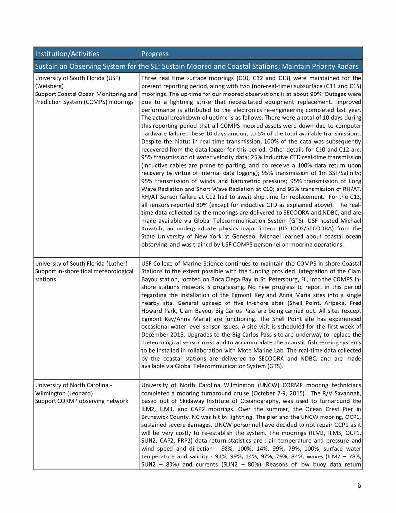
University of Georgia (Noakes) and University of Delaware (Wei-Jun Cai) Support to NOAA’s Ocean Acidification Program NDBC Gray’s Reef National Marine Sanctuary (GRNMS) buoy
To date, the Gray’s Reef National Marine Sanctuary (GRNMS) buoy has been reporting data nearly continuously since 2006 when the MAPCO2 system was installed (Figure 1). The system requires annual visits to the buoy to replace all components. Periodically individual components need to be replaced as needed due to biological fouling, weak batteries, or storm damage. During this reporting period, the system has functioned well and has not needed any emergency repairs. The National OA buoy network website has also recently been redesigned and is more interactive than during previous versions. Visitors to the website can now readily change from weekly, monthly, yearly or the entire data set.
The University of Georgia (UGA) and GRNMS visited the National Data Buoy Center buoy at GRNMS to replace the MAPCO2 ocean acidification (OA) package currently installed on the buoy. The GRNMS RV Ferguson, a 41 ft research vessel was used for transit to the sanctuary. All parts of the OA package (electronics, battery pack, gas equilibrator, span gas and iridium antenna/GPS) were replaced except the

8
Institution/Activities Progress
Sustain an Observing System for the SE: Sustain Moored and Coastal Stations; Maintain Priority Radars
Sunburst sensor SAMI-pH and Seabird water quality sonde. Sea conditions were too rough to safely work under the buoy so that part of the operation was delayed until a day with calm sea conditions can be scheduled. A new iridium antenna bracket had been designed at UGA to fit the buoy and the new design antenna. This new bracket was mounted on the buoy during this service operation. This bracket allows for an easier antenna exchange for future replacement operations. Eight water samples were collected near the buoy during the day (2 upon arrival, 2 during the servicing effort and 2 immediately before departure from GRNMS). These samples were spiked with mercuric chloride (HgCL2) for preservation and placed on ice until return to Athens, Georgia. The samples were then sent to the University of Delaware for analysis. The following day, it was realized that the MAPCO2 system was not transmitting to the PMEL facility as programmed. After discussion with PMEL, it was determined that the problem was either in the iridium antenna or the MAPCO2 electronics package. On October 30, 2015 UGA and GRNMS once again visited the buoy. After a series of diagnostics tests, it was determined that the iridium antenna was not functioning. The MAPCO2 program had previously booted properly since the GPS part of the system was working, but the iridium was not able to transmit. A replacement iridium/GPS antenna was installed on the buoy and the system was able to transmit data to PMEL. The system is now transmitting every 24 hours to PMEL. Sea conditions were still too rough to work under the buoy. UGA and GRNMS are currently watching the sea forecast for a potential date to replace the SAMI-pH and Seabird mounted under the buoy. Replacement of these sensors will not require rebooting the MAPCO2 so data transmission should not be interrupted as a result of this task.
Maintain High Frequency Radar Operations
University of South Florida (Weisberg, Merz) Support three CODAR and two WERA radar arrays on the West Florida Shelf
USF continue to operate and maintain the US IOOS/SECOORA identified priority CODAR system radar sites (Naples, Venice and Redington Shores), along with two WERA sites (Venice and Ft. DeSoto Park) overlooking our moored array. Data are sent to SECOORA and the National High Frequency Radar Network for integration, display and dissemination. Additionally, we continue to procure components for installing a fourth CODAR site. We continue to work with other SECOORA region HF Radar operators to standardize operations, data delivery, display and dissemination, maintain data integrity and provenance, provide accuracy estimates of surface currents and develop common data products for stakeholders. The performance metrics (temporal and average spatial range) of the CODAR systems indicate operation for 92.0% and 181km, 93.0% and 162km and 64% and 184km, for the period 1 June 2015 to 30 November 2015 for the Reddington Shore, Venice and Naples, respectively. The performance metrics of the WERA systems indicate operation for 96% and 144km and 86% and 129km for the period 1 June 2015 to 30 November 2015 for the Fort DeSoto and Venice, respectively. With the exception of the Naples CODAR and Venice WERA sites, all sites exceeded 90% up-times. The Venice WERA site outage was due to intermittent failure of the 7-year old Frequency Control Receiver (FCR), which, after repeated attempts/site visits, was replaced by a spare component, with the original FCR sent back to the vendor for repair, where it currently resides. The Naples CODAR site outage was due to a lightning strike(s) that necessitated significant equipment replacement/repair. The site was down for nearly two months with almost all equipment needing replacement or repair. Program funds had to be re-programed in order to get these repairs underway with current repair costs for those pieces of equipment

9
Institution/Activities Progress
Sustain an Observing System for the SE: Sustain Moored and Coastal Stations; Maintain Priority Radars
already completed or underway exceeding $12K.
Skidaway Institute of Oceanography (SkIO) (Savidge) Support two WERA radar arrays on St. Catherine’s and Jekyll Island, GA
SkIO continued to operate two WERA HFRs on St. Catherine’s Island and Jekyll Island, GA for this reporting period. The data are being continuously provided to SECOORA and the U.S. National HFR Network archive in near-real time. Estimates of wave and wind parameters are also made as experimental products. Operational uptime and average spatial range statistics for the period from 1 June 2015 to 30 November 2015 of St. Catherine’s Island and Jekyll Island HF Radar sites are: 99.9%, 181km, 91.2%, 192km. WERA system components continue to require replacement and repair. We spent the summer months troubleshooting and repairing a newly installed frequency control computer whose shutdowns resulted in intermittent data outages. After extensive documentation, the manufacturer agreed to replace the defective part in September 2015. There have been no outages since replacement. More equipment upgrades will be made during the winter of 2015-16.
University of Miami (Shay) Support three WERA radar arrays at Crandon, Virginia Key and Dania Beach
The University of Miami operates WERA HFR installations on Key Biscayne (Crandon), Virginia Key and Dania Beach. Crandon operates at 16 MHz, Dania Beach and Virginia Key operates at 12 MHz. Virginia Key site was damaged by a fire set by Park visitors on the evening of 24 May and is now operational. With respect to Dania Beach, we had several issues to deal with: 1) Moved the container to comply with US Navy Managers; 2) Repaired (re-spliced) cables multiple times since rodents were eating cables close to the container; 3) Shut down the site for a 2 to 3 week period for classified Navy experiment and more recently for a few days while fiber optic cables were being installed at the Navy’s SFTF site. Estimated significant wave heights for the National Weather Service (NWS) marine forecast models and engage stakeholder groups such as the National Weather Service (NWS) and United States Coast Guard (for currents). Operational uptime and average range statistics of three priority HF Radar sites for this reporting period (1 June 2015 – 30 November 2015): CDN – 93%, 125km, STF – 70.1%, 77km and VIR – 71%, 123km.
University of NC - Chapel Hill (Seim) Support two CODAR radar arrays on the Outer Banks of NC
The UNC-CH operates 3 CODAR-radar installations on the Outer Banks of North Carolina with SECOORA/IOOS funds. Each site required significant maintenance during the reporting period. The HATY site air conditioner started failing and was replaced, the ground plane wires were corroded and replaced, and its generator was failing to start and required servicing. The air conditioner at CORE failed and was replaced, which also required a larger battery bank. The air conditioner failure caused the Mac Mini computer to overheat and fail. This allowed for a pre-planned conversion/replacement Mac Mini to be installed that runs on DC power, improving efficiency. Cables at CORE were damaged (presumably by animals) and were replaced. The TX cable at DUCK was accidently severed by USACE Field Research Facility staff and required splicing, and its ground plane wires also were corroded and replaced. Erosion led to the need for replacement of a screw anchor and guy line relocation for the Duck transmit antenna. The Duck transmit antenna will be moved soon, with a transmit cable replacement being relocated and buried in PVC to avoid it being severed in the future. A new Automatic Identification System (AIS) software package from Codar will also be installed during the transmit antenna upgrades, and will provide continuous antenna pattern measurements monitoring for changes in the pattern over time. We continue testing quality control procedures for radials from these sites. We have implemented in post-

10
Institution/Activities Progress
Sustain an Observing System for the SE: Sustain Moored and Coastal Stations; Maintain Priority Radars
processing the threshold tests and weighted-averages advocated by Kirinich et al. (2012) and find that monthly-averaged radials speeds are significantly impacted; increases of 20% are common. An important aspect of the work is that QC code is constructed to work within the existing software flow from the vendor. We recently presented results at ROWG and have made the code available on GITHUB. We continue to develop Gulf Stream landward edge tracking capabilities with the NC radars, and compare them with existing data products. Initial comparison with NAVO depictions of the Stream edge find the radar determinations to be noticeably farther offshore, consistent with the NAVO charts including Stream meanders and filaments. Work is underway to utilize the QC’ed dataset as the basis for the work. We are also exploring other data sets for comparison with the radar. Initially, we will compare two years of continuous ADCP current measurements within the footprint of the HATY radar with proximal radar surface current measurements. Uptime statistics June 1, 2015- November 30, 2015: HATY: 98%, 167 km average range; DUCK: 95%, 186 km average range; CORE: 70.7%, 191 km average range (several weeks of downtime due to cable cut). Hourly data from the systems are delivered to SECOORA and the U.S. National HFR network archive.
University of South Carolina (Voulgaris) Support two WERA arrays on Fort Caswell, NC and Georgetown, SC
The University of South Carolina currently maintains, operates and delivers data from two priority radar sites (Fort Caswell, NC and Georgetown, SC) covering Long Bay, SC. The operation of the two systems was continued without major interruptions during the reporting period, despite a number of issues developed with the GTN site due to failure of the Uninterruptable Power Supply (UPS) unit and an interruption in data transmission to HFR Net due to firewall issues between the University and HFR Net systems. The relocation of the antennas further inshore at GTN in Spring 2015 has eliminated the issues associated with marine turtle nesting that were present during the summer of 2014. Data communication between the University of South Carolina and the HFR Net servers was interrupted on August 11th, 2015. Since the systems were operational and data were available to use it was not until August 19th, 2015 that we were notified by HFR Net that data were not made available to the national database. Upon further investigations, the problem was identified to changes in the firewall settings by the University of South Carolina IT services. The problem appeared to be rectified on August 24th, 2015, but within a few hours it re-appeared. It was resolved on August 29th through the establishment of new channels and port re-directions. On July 21st, 2015 data collection in GTN was interrupted because of failure of the UPS installed on the field. After identifying the problem we re-established connection on July 23rd by operating the station without a UPS protection and we ordered a new replacement. The new UPS was installed on July 29th 2015. Operational uptime and average spatial range statistics for the period from 1 June 2015 through 30 November 2015 for Fort Caswell, NC and Georgetown, SC HFR sites are: 94%, 162km, 89%, 229km. The data from each station are provided in near real-time to SECOORA and the US National HFR network. If we exclude the periods of data communication issues, the CSW station was operational for 100% of the time while GTN was operational for 95% of the time.

11
Goal 3: Support a Multi-Scale Multi-Resolution Modeling Subsystem
Milestones: The following table provides progress on the modeling subsystem projects.
Institution/Activities Progress
North Carolina State University (He) Support and enhance SABGOM model
The North Carolina State University South Atlantic Bight Gulf of Mexico (SABGOM) model continues to run on a 24/7-basis, providing three-dimensional (3D) regional ocean predictions. The model provides daily 72 hour nowcast/forecast, and model output (sea level, temperature, salinity and 3D currents) are made available via the SECOORA website and the NCSU PI’s website. SABGOM model has been coupled with a biogeochemical prediction model, and testing of data assimilation (DA) schemes within the SABGOM modeling system using 3D-variable and 4D-variable data assimilation schemes is continued. The DA system, once fully implemented, will be able to assimilate observations including satellite sea surface temperature, sea surface height, HFR surface currents, and glider observed hydrography to improve SECOORA regional ocean circulation predictions.
University of Florida (Sheng) and North Carolina State University (Xie) Provide real-time forecasting of inundation and storm surge.
University of Florida: The 24/7 ACMS (Advanced Coastal Modeling System) forecasting system was kept running throughout the 2015 hurricane season generating nowcasts and forecasts and making its output available. StormSurgeViz is a tool developed by the Joint Hurricane Testbed (JHT) and it’s tailored more towards the ADCIRC model therefore alternative data output options were developed for ACMS to output data in formats that could be used by the StormSurgeViz tool. Alternative THREDDS catalogs were developed to provide the aforementioned data in StormSurgeViz compatible format so that it could be ingested by the Joint Hurricane Testbed. This output option and catalogs are currently available for all ACMS domains. No significant storm activity was observed during the period of operation of this system therefore we were unable to test the system in real time. We are undergoing testing using historical products comparing results with other JHT products based on official NHC tracks. North Carolina State University: For this reporting period, the stated goal is to maintain the CMAEPS modeling system and prepare a final progress report covering the entire project period on the Real-Time Coastal Ocean Forecasting in Support of Management of Coastal Resources and Emergency in the SECOORA Region project. During this reporting, we continue to maintain the NCSU Coastal Marine and Atmospheric Environment Prediction System (CMAEPS) which is running in the near-real-time mode on the NCSU IBM Blade Center Linux Cluster (henry2). CMAEPS performs a 3-day forecast daily with the system being initialized at 00 UTC. Near real-time forecasts from NCEP 0.5 degree Global Forecast System (GFS) data from NOAA National Operational Model Archive & Distribution System (NOMADS) are used to drive the regional atmospheric model by providing initial and lower boundary conditions and 6-hourly updated lateral boundary conditions. Atmospheric forcing fields from the atmospheric model then drive the surface wave model and the storm surge model. Tidal boundary conditions are specified according to the ADCIRC tidal database. During the past 6 months, we also carried out hardware upgrades, including installation of new data drive and upgrading the data server, but the system is not stable and further updates are planned when resources become available.

12
Institution/Activities Progress
University of South Carolina (Porter) Provide a decision support tool for beach/shellfish water quality advisories.
Statistical models were developed for each of the 12 sampling sites (five marine sites are located on Anna Maria Island, two on Longboat Key, three on Lido Key, one on the causeway to Anna Maria Island, and one on Ringling Causeway) in our study area west of Sarasota, FL. The EPA’s Virtual Beach (VB) statistical modeling toolbox was utilized for this effort. VB was used to create multiple linear regression models from roughly 82 variables. Eighteen (18) models were created for each sample site. These models consisted of in situ model runs using the C10 buoy, in situ model runs using the C10 buoy at 1m, and in situ C10 buoy model runs with associated HYCOM modeled data. Once standard models were created, input variables were transformed and run to develop additional predictive models. Then, island-wide models were created in which models were created for each of the barrier islands in our study area (12 models for each of the following barrier islands: Anna Maria Island, Longboat Key, and Lido Key). These models were also created using in situ data from the C10 buoy, in situ model data from the C10 buoy at 1m, and C10 buoy in situ data with associated HYCOM modeled data; models were further developed using both AO and non-AO wind components developed from the VB modeling software. Once models were developed, near-real-time data was/is utilized to provide daily predictions of bacteria concentration.
Independent Contractor (Filipe Pires Alvarenga Fernandes, Oceanographer, Brazil) and Collaborator and consultant (Richard Signell, USGS) Python Data Analysis Tools for Oceanographers Services
Task 1: IOOS System Integration Test webpage/blog: The System Integration Test (SIT) webpage is online and the first post explaining the page goals is up. Posts will be added on a weekly basis. The basic workflow is to parse the IPython notebooks created during the SIT and then publish those files as a GitHub project page. The notebooks are converted to HTML using IPython’s own nbconvert and the HTML is parsed by a static blog generator, Pelican, via a Pelican IPython-notebooks plug-in. The site configuration can be tweaked by changing the pelicanconf.py file and the publishing options in the publishconf.py. Note that while the actual publish HTML is hosted on GitHub, its version control is meaningless. The HTML is overwritten at every new push. One should follow the changes of the notebooks and configuration on the master branch to keep track of the changes. Task 2: Support current and continue developing important software packages to the IOOS enterprise: The IOOS enterprise is concerned with the software stack sustainability. To address that we started a GitHub repository to discuss the state of the software APIs developed under the IOOS umbrella. Two projects already started due to the discussions that took place: the Ocean Dimensionless Vertical Coordinates (odvc) and Isosurfaces (iso). Both projects have a single goal: provide the simplest, and the most canonical possible, way to perform a single purpose task. The odvc module contains ocean vertical coordinates equations to compute the dimensioned version of the coordinates whereas iso provides means to perform horizontal slices in any kind of ocean model grid. Two other projects that started before APIRUS but have the same goals are tardis and cf_units. The cf_units provides an interface to units CF-conventions via UDUNITS. The module can be considered stable and is ready for production and it is used by IOOS compliance-checker. The UK Met office iris developers, for example, are interested in collaborating to foster some these modules, like cf_units and

13
Institution/Activities Progress
odvc. Task 3: Perform documentation/planning/testing to further mature the projects and maximize the likelihood of external contributions: This task is an intrinsic part of tasks 1 and 2. The SIT webpage creation is self-documented and its main goal is to maximize external contributions. The APIRUS repository was created with the intention of being a place for planning and testing software. All the modules that already originated from this effort are fully documented with docstrings and, once they are complete, the creation of manual pages will be trivial. However, since we know that documentation alone is not enough, we will be posting usage examples in the SIT webpage. Task 4: Support, maintain and upgrade the SECOORA Model Skill Assessment tool: SECOORA model skill assessment maintenance and upgrade is being continued. The tool is being integrated into SECOORA DMAC infrastructure.
Goal 4: Enhance the DMAC Subsystem
Milestones: Updates on activities are described in “progress” column of the following table.
Institution Progress
University of SC (Porter)
Maintain SECOORA DMAC Infrastructure.
Develop and deliver the materials/documentation needed to enable transition of DMAC services from USC to Axiom
Develop and provide a final project report
The University of South Carolina (USC) continued to maintain DMAC infrastructure. The SECOORA website membership and some other website pages using Google spreadsheets to retrieve data had to be upgraded to handle changes in how Google authenticates retrieval from those spreadsheets. On the SECOORA website, the link to the older interactive map was removed and replaced by the link to the more recently developed 'Map Portal'. On the SECOORA data portal the web service map of the national hfradar centers was added as a layer under the layer 'High Frequency Radar->HR Radar - National' to complement the regional hf radar feeds presentation. Project is now in maintenance mode; updates to data endpoints and server software were performed. Worked with USF to enable WERA HF radar files to be presented as a THREDDS netcdf aggregation and to generate “How-To” documentation on THREDDS installation and data aggregation for USF staff.
Axiom Data Science, LLC (Wilcox) Working with RCOOS Manager (Subramanian), we set short, medium, and long term objectives for the transition, implementation and management of SECOORA’s DMAC system. Work is in progress on the development and implementation of SECOORA data portal. During this reporting period, assisted SECOORA staff and PIs in developing the DMAC section for SECOORA U.S. IOOS FY 2016 Federal Funding opportunity.
RCOOS Integration Projects
Institution/Activities Progress
Trap Puckett, RPS Evans Hamilton, John’s Island, SC – Rip current model validation
Task 1: Deployment of 2 bottom mounted wave gages off of Emerald Isle NC: Completed August 28, 2015; Task 2: Recovery of 2 bottom mounted wave gages: Completed November 11, 2015; Task 3: Analysis of data from 2 bottom mounted wave gages: Ongoing; Task 4: Installation of cameras in Emerald Isle Completed June 18, 2015; Task 5: Demobilization of cameras: Completed November 12, 2015; Task 6: Analysis of the data from camera systems: Ongoing. Data from camera system is available at http://video-monitoring.com/beachcams/rps/

14
Institution Progress
James Locascio, Mote Marine Laboratory, Sarasota, FL – Ocean Observing Experiment: Incorporation of Passive Acoustics and Acoustic Telemetry on an Established Regional Coastal Ocean Observatory to Measure Fish Sound Production and Behavior as an Indicator of Ecosystem Function
Equipment including atmospheric and in-water sensors, receivers, communication hardware, and some mounting hardware including a replacement mast for the Big Carlos Pass station have been ordered and received. The Campbell Scientific CR3000 datalogger was sent to the factory for a diagnostic check and calibration, has been returned to the PIs, and is authorized for use. The Campbell datalogger has been configured to poll all integrated sensors at regular intervals and a template has been designed for data management during storage and transmission via IP modem and through the GOES. The system, including the Cambpell data logger, Vemco VR2C receiver, and IP modem are operating successfully. We are presently working on integrating the passive acoustic circuitry for recording ambient sounds (e.g. fishes, marine mammals, etc.). The passive acoustic circuitry is the last component of the system that needs to be integrated and tested successfully in the lab. Following this, the system will be deployed for field testing at USF College of Marine Science prior to deployment at the Big Carlos Pass field site.
Baruch Institute, University of South Carolina (Smith)
Instrumentation support for a water quality monitoring station in the central channel of Winyah Bay
All instrumentation for which funds were requested has been purchased. Specifically, we purchased two YSI EXO2 data sondes equipped with conductivity/temperature, pH, dissolved oxygen, and turbidity sensors plus associated anti-fouling guards, as well as one Suttron satellite telemetry package consisting of a SatLink2-V2 and 10dB satellite antenna, solar power supply system, lightning protection and enclosure system. Initial construction and installation of the proposed monitoring station was planned for late July, 2015, but this has not yet occurred for a variety of reasons. The pile-driving company contracted to drive the 45’ long 12” butt pilings that form the station infrastructure has been delayed throughout the summer by larger projects. Since this is the only contractor in the Winyah Bay area capable of driving such pilings in deep open water, there was little choice but to accept their postponements. The work was then on track for an early October installation date, but this had to again be postponed due to the October flooding event and flow conditions that made the work impossible. As of this report, the work has been rescheduled for late November to accommodate the contractor’s schedule.
Skidaway Institute of Oceanography (SkIO) (Savidge)
South Atlantic Bight Synoptic Offshore Observational Network (SABSOON) Tower Data recovery project
Preliminary Quality-Control of archived SABSOON data for 3 offshore towers is underway. Up to 10 years (1999-2009) of in-water and meteorological information is being scrutinized. Initial inspection includes near-surface and near-bottom water temperature, conductivity, salinity, depth, chlorophyll and PAR. Water level, wave, meteorological variables and ADCP currents will be examined next. Various QC flags are being assigned to suspect data by parameter.
Goal 5: Support a Targeted and Leveraged Education and Outreach Subsystem
The primary focus of SECOORA’s Education and Outreach (E&O) subsystem is to engage stakeholders in observing technologies, data, products, and services. Note that Goals 1, 3, and 4 include outreach activities that complement and contribute to the E&O subsystem. We have listed work carried out during this reporting period below. No Education and Outreach PIs were funded in Year 5.

15
Education and Outreach Activities
SECOORA continued to engage in outreach activities via e-newsletter, e-mails, social media and website. SECOORA sent e-newsletters, referring and increasing traffic sessions to our website during this reporting period. We sent emails outlining staff activities to the Board. Stories highlighting Members work, SECOORA newsletters and more were published on our website. We continue to engage in outreach and education events as well as provide materials to RCOOS PI and Board members, who attend science meetings, provide information to governmental representatives, etc. SECOORA staff and Members engaged in many in-person outreach events, including meeting with Congressional Staff.
SECOORA In-person Outreach: SECOORA staff constantly engaged in either delivering a talk at institutions or visiting institutions and attending meetings to promote the need for the implementation of Regional Coastal Ocean Observing Systems to address coastal zone issues. The following are some outreach activities that occurred during this reporting period: Weather Ready Nation events; West Central Florida American Meteorological Society events; Marine Technology Society Events; Florida Atlantic Coast Telemetry (FACT) group coordination; Florida Gulf Coast University Real-time Basic Observation Buoy Retrieval and Deployment; New College of Florida, Sarasota Data Science Program faculty meetings; Undergraduate Environmental Science Lab Tours USF Clam Bayou Water Quality Monitoring Station; GCOOS-RA meeting, St. Petersburg; Debra joined Zdenka Willis (U.S. Integrated Ocean Observing System Director) in a visit to Coastal Carolina University, Conway, SC (August 21, 2015); GCOOS-RA meeting, St. Petersburg (September 17, 2015); NOAA Southeast and Caribbean Regional Collaboration Team (SECART) meeting, Ashville, NC (September 22-24, 2015); 2015 St. Petersburg Science Festival (October 16-17, 2015); MTS/IEEE Oceans’15, Maryland, October 19-22, 2015; Climate Variability and Fisheries workshop, St. Petersburg, FL, October 26-28, 2015); Integrated Tracking of Aquatic Animals in the Gulf of Mexico (iTAG) conference calls and meeting (St. Petersburg, FL, October 29-30, 2015); Radiowave Oceanography Workshop, Woods Hole Oceanographic Institute (WHOI), MA. (November, 4-6, 2015); and Florida Atlantic University Indian River Lagoon (IRL) Connecting Data with users workshop (December 7-8, 2015).
During this reporting period, we conducted our SECOORA Board meeting in Charleston, SC (December 3-4, 2015).
Scope of Work Scope of work remains as proposed in Year 5 descope proposal.
Personnel and Organizational Structure No major changes in SECOORA personnel or organizational structure were made during this reporting period. A current list of SECOORA Members and Board is available on our website. Kathleen O’Keife, FWC/FWRI resigned from board in the month of November and her seat is vacant at the submission of this report. SECOORA's Board elected new officers during this reporting period (Chair- Conrad Lautenbacher, GeoOptics; Vice Chair – Bill Hogarth, Florida Institute of Oceanography; Treasurer – Peter Hamilton, Leidos Corporation; Secretary – Jim Nelson, SKIO, UGA; At Large: George Maul, Florida Institute of Technology). Budget Analysis The FY15 SECOORA A-133 audit was conducted by the firm Elliott Davis Decoscimo, LLC and was finalized in October 2015. There were no negative findings. SECOORA’s October 31, 2015 financial report shows a budget balance remaining of
approximately $700K (Year 4 funds) and a budget balance remaining of approximately $2.3M (Year 5 funds). We are within
budget and on track with spending. There were 16 no cost extensions granted to Year 4 sub-awardees ranging from six months to one year. We started to draw IOOS Year 5 funds in June 2015. SECOORA continues to receive invoices regularly from our sub-awardees and we process them at one of two bi-monthly administration meetings. All invoices are paid within forty-five days. SECOORA continues to draw from ASAP monthly. As a reminder SECOORA pays out its monthly operational costs (i.e. payroll, etc.) and then conducts the ASAP draws in the middle of the following month for both the preceding month’s operation expenses and the sub-awardee invoices.
Publications and Presentations Muglia M., He R., Lowcher C., Bane J, Taylor P., Edge B. Observation and regional model based Gulf Stream marine
hydrokinetic energy resource estimates for North Carolina, Paper presented at MTS/IEEE Oceans 2015: October 19-22,
2015. Washington, D.C.
Haines, S., H. Seim and M. Muglia, Update on Quality Control of Seasonde radial currents, presented at ROWG, Woods Hole,
MA, Nov. 3-5, 2015.
16
Xue, L., Cai, W-J., Hu, X., Sabine, C., Jones, S., Sutton, A.J., Jiang, L-Q., Reimer, J.J., Sea surface carbon dioxide at the Georgia
time series site (2006-2007): air-sea flux and controlling processes, Progress in Oceanography (2015), doi:
http://dx.doi.org/10.1016/j.pocean.2015.09.008
Neet, M., R.H. Kelsey, D.E. Porter, D. Ramage and A. Jones. Model performance results in Myrtle Beach, SC using Virtual
Beach and R regression software. Submitted to South Carolina Water Resources Journal. In review.
Porter, D.E., J. Dorton, L. Leonard, H. Kelsey, D. Ramage, J. Cothran, A. Jones, C. Galvarino, V. Subramanian and D.
Hernandez. Integrating environmental monitoring and observing systems in support of science to inform decision making:
case studies for the Southeast. Chapter in Coastal Ocean Observing Systems: Advances and Syntheses. Y. Liu, H. Kerkering
and R. Weisberg (eds.). Elsevier Press.
Huang, W.-J., W.-J. Cai, Y. Wang, X. Hu, B. Chen, S. E. Lohrenz, S. Chakraborty, R. He, and C. S. Hopkinson (2015) The
response of inorganic carbon distributions and dynamics to upwelling favorable winds on the northern Gulf of Mexico
during summer, Continental Shelf Research, in press.
Yao, Z., Z. Xue, and R. He (2015) Statistical downscaling of IPCC sea surface wind and wind energy predictions for the U.S.
east coast ocean, the Gulf of Mexico and the Caribbean Sea, Journal of the Ocean University of China, in press
Ren, W., H. Tian, B. Tao, J. Yang, S. Pan, W.-J. Cai, S. E. Lohrenz, R. He, and C. S. Hopkinson (2015) Large increase in dissolved
inorganic carbon flux from the Mississippi River to Gulf of Mexico due to climatic and anthropogenic changes over the 21st
century, Journal of Geophysical Research - Biogeosciences, 120, doi: 10.1002/2014JG002761.
Tian, H., W. Ren, J. Yang, B. Tao, W.-J. Cai, S. E. Lohrenz, C. S. Hopkinson, M. Liu, Q. Yang, C. Lu, B. Zhang, K. Banger, S. Pan,
R. He, Z. Xue (2015) Climate extremes dominating seasonal and interannual variations in carbon export from the Mississippi
River basin, Global Biogeochemical Sciences,29, doi: 10.1002/2014GB005068.
Archer, Shay, Jaimes and Martinez. Integrating environmental monitoring and observing systems in support of science to
inform decision making: case studies for the Southeast. Chapter in Coastal Ocean Observing Systems: Advances and
Syntheses. Y. Liu, H. Kerkering and R. Weisberg (eds.). Elsevier Press.
A paper was accepted in the Asian Oceanic and Geoscience Society conference in Singapore (3-7 Aug 2015) entitled The
Florida Current in Stream Coordinates: Effects of Meandering at 25 to 26oN by Archer and Shay. More recently, Archer
presented recent results from his PhD research on HF Radar Observations of the Florida Current In Stream Coordinates at
the ROW meeting in Woods Hole from 4-6 Nov 2015.
University of South Carolina: The PI (Voulgaris) and his 2 graduate students (Douglas Cahl and Zaid Al Attawabi) attended
the 2015 Radiowave Oceanography Workshop (2015 ROW) meeting that was held at the Woods Hole Oceanographic
Institution, MA during the period November 4-6, 2015. Voulgaris was the only PI representing the SECOORA radar
operators. Jeff Jefferson who provides operational support and contributes to the maintenance of the radar systems
attended the Radiowave Operators Working Group Meeting (ROWG), ROWG-8 HF Radar Ocean Remote Sensing that was
held during the period November 2-4, 2015 also at the Woods Hole Oceanographic Institution, Woods Hole, MA. A
presentation titled “HF radar sensitivity to Stokes' drift as a function of wave conditions and operating frequency” by D. Cahl
and G. Voulgaris was presented at the meeting by D. Cahl (see: http://www.whoi.edu/workshop/row2015/agenda-and-
schedule)
17
Weisberg, R.H., L. Zheng and Y. Liu (2015). Basic tenets for coastal ocean ecosystems monitoring, in Coastal Ocean
Observing Systems, Y. Liu, H. Kerkering and R.H. Weisberg, eds., Elsevier, London, ISBN: 978-0-12-802022-7, 461pp.
Liu, Y., H. Kerkering and R.H. Weisberg (2015). Introduction to Coastal Ocean Observing Systems, in Coastal Ocean
Observing Systems, Y. Liu, H. Kerkering and R.H. Weisberg, eds., Elsevier, London, ISBN: 978-0-12-802022-7, 461pp.
Liu, Y., R.H. Weisberg and C. Lembke (2015). Glider salinity correction for unpumped CTD sensors across a sharp
thermocline, in Coastal Ocean Observing Systems, Y. Liu, H. Kerkering and R.H. Weisberg, eds., Elsevier, London, ISBN: 978-
0-12-802022-7, 461pp.
Merz, C., Y. Liu, K-W. Gurgel, L. Pedersen and R.H. Weisberg (2015). Effect of radio frequency interference (RFI) noise
energy on WERA performance using “Listen Before Talk” adaptive noise procedure on the west Florida shelf, in Coastal
Ocean Observing Systems, Y. Liu, H. Kerkering and R.H. Weisberg, eds., Elsevier, London, ISBN: 978-0-12-802022-7, 461pp.
Weisberg, R.H. and L.Y. Zheng. A West Florida Coastal Ocean Model (WFCOM). Presented on 9/28/2015 at 2015 BASIS6
workshop in St. Petersburg, FL.
Weisberg, R.H. and L.Y. Zheng. A West Florida Coastal Ocean Model (WFCOM). Presented on 10/20/2015 at 2015 FVCOM
workshop in Bedford Institute of Oceanography, Dartmouth, Canada.
Zheng, L.Y. and R.H. Weisberg. A High Resolution Tampa Bay and Vicinity Circulation Model with Applications to Flushing
and Salt Balance. Presented on 10/21/2015 at 2015 FVCOM workshop in Bedford Institute of Oceanography, Dartmouth,
Canada.
Liu, Y., R.H. Weisberg, and S. Vignudelli. Patterns of the Loop Current System and Regions of Sea Surface Height Variability
in the Eastern Gulf of Mexico Revealed by the Self-Organizing Maps. Presented on 10/18/2015, 9th
Coastal Altimetry
Workshop, Reston, Virginia.
Zheng, L.Y. and R.H. Weisberg. Coordinating Observation Network and Numerical Modeling on the West Florida Shelf.
Presented on 06/27/2015 in Island Research Center, SOA, Pingtan, Fujian, China.
Zheng, L.Y., R.H. Weisberg and Y. Liu. West Florida Coastal Ocean Model: Downscaling from deep-ocean, across the
continental shelf and into estuaries by nesting FVCOM into GOM HYCOM. Presented on 06/05/2015 in Gordon Research
Conference: Coastal Ocean Modeling in University of New England, Biddeford, ME.
Zheng, L.Y., J. Zhu and R.H. Weisberg. On the salt balance of Tampa Bay, Florida. Presented on 06/05/2015 in Gordon
Research Conference: Coastal Ocean Modeling in University of New England, Biddeford, ME.
Zheng, L.Y. and R.H. Weisberg. Has There Been a Trend in Eastern Gulf of Mexico Temperature in Recent Decades?
Presented on 09/28/2015 at BASIS6 in St. Petersburg, Florida.
Outreach Activities and Materials Numerous outreach materials have been developed for specific audiences and are available at www.secoora.org. University of South Carolina, Columbia, SC, George Voulgaris Data from this project are used to support two Ph.D. students Douglas Cahl (supported by the project) and Mr. Zaid Al Attawabi (funded externally through a fellowship). In addition, an undergraduate Marine Science student (Nolan Snyder) is engaged in a project where he attempts to calibrate the radars using reflections from ship signals that pass through the coverage area. Furthermore, Jeff Jefferson a USC staff member engaged with the maintenance of the HF Radars routinely

18
interacts with the public visiting the beaches, especially residents of DeBordieu Colony and explain the principle of operation and the uses of HF radar data for the public. University of North Carolina – Wilmington, NC, CW Lynn Leonard Lynn Leonard is a member of the SECOORA Board of Directors and she participates at board meetings (in person and calls) as well as participating on the SECOORA proposal development committee for the 2016-2021 IOOS RFP. In November, Lynn Leonard completed her tenure as a member of the IOOS FACA. Jennifer Dorton is the Coordinator for NOAA’s North Carolina Sentinel Site Cooperative. In this role she is working with other federal agencies to create partnerships that will enable the Cooperative and partners to move forward on sea level rise research and outreach. The Cooperative’s Core Management Team is working with East Carolina University and the NC Coastal Atlas project team to create a GIS-based Clearinghouse for Sea Level Rise and resiliency projects within the Cooperative’s boundaries. SECOORA is a member of the advisory board for the NC Coastal Atlas. Jennifer Dorton is on the NC Coastal Atlas Steering Committee as the SECOORA representative. University of South Florida, St. Petersburg, Mark Luther M. Luther made a presentation to the Gulfport City Council on July 21, 2015, describing the Clam Bayou site. In August 2015, there was a release of 15,000,000 gallons of untreated or partially treated sewage into Clam Bayou. Impacts to water quality in the bayou and adjacent Boca Ciega Bay were observed by our site there. We continue to work with the cities of Gulfport and St. Petersburg to assess the impacts of the release. We are assisting the City of St. Petersburg in design and permitting of the new city pier, Pier Park. M. Luther, J. Scudder, and A. Wakely conducted tours of the Clam Bayou site for a USFSP Environmental Sciences class on Oct. 20 and 21, 2015. M. Luther participated in the Tampa Bay Climate Science Advisory Panel in drafting the document “Recommended Projection of Sea-Level Rise in the Tampa Bay Region” that was distributed to the Tampa Bay Regional Planning Council’s ONE BAY Resilient Communities Working Group in October 2015. Clam Bayou Water Quality monitoring teacher training activities - Undergraduate Environmental Science Lab Tours Water Quality Monitoring Station (October 2015). University of South Florida, St. Petersburg, Robert Weisberg Served at http://ocgweb.marine.usf.edu is a HAB tracking tool, joint with the FWC. The FWC provides qualitative measures of K. brevis cell counts (present to high concentrations), and we provide daily forecasts of trajectories at the surface and bottom using our West Florida Coastal Ocean Model (WFCOM) consisting of FVCOM nested in HYCOM. Pro-bono consulting for Tierra Verde resident group and the Tampa Bay Watch on sediment transport and ecosystems issues. Fisheries discussions with FWC and related proposal development. Fisheries and Climate workshop at St. Pete Beach Florida 10/26-10/28. FWC harmful spill exercise supported by WFCOM made available on NOAA GOODS via netcdf Developed two RESTORE Act proposals with Pinellas Co. We continue to partner with FGCU for hosting interns and outreach to undergraduates. We secured funding for a 2015 summer intern through the IOOS Program Office. The internship was a great success as we hosted an undergraduate physics major who has now decided to pursue graduate studies in Physical Oceanography beginning next year. Assisted FGCU in the deployment of two Basic Observation Buoys. Partnered again with FGCU in the competitive award of three FIO state sponsored ship days. The award necessitated the active participation of two FGCU undergraduate students in developing a senior thesis project centered around deploying in-situ instrumentation on COMPS moorings. COMPS/SECOORA observations and models are regularly looked at by the local NOAA WFO in Ruskin, FL. COMPS/SECOORA observations accessed (through NOAA) by local weather outlets and commercial vendors (Example OceanWeather). For instance, consider the image copied below today, (November 16th 2015) from the private sector provider, OceanWeather, using COMPS/SECOORA sites C10, C12, C13 identified as NOAA buoys. University of North Carolina, Chapel Hill, Harvey Seim We continue to share information on the radar system in annual reports to the National Park Service, with Groups Cape Hatteras (where the Buxton radar is located) and Cape Lookout (where the Core Banks radar is located). ROFFS Inc. Mitch Roffer
19
We reached out to numerous commercial and recreational fishermen to learn about their observations and thoughts of climate variability and change. Roffer attended the Southeast Fisherman’s Association meeting and made a presentation and took a survey of the members regarding climate change and ocean monitoring. Roffer also presented research results at the CLIOTOP international meeting in Spain in September, 2015. While this was paid for by his NASA grant, he presented his SECOORA project work on fisheries ecosystem modeling for several demersal species in the South Atlantic region. University of Georgia, Athens, GA, Scott Noakes On June 16, the principle investigator gave a presentation on the Southeast Ocean and Coastal Acidification Network (SOCAN) webinar series entitled Coastal Mooring at Gray’s Reef National Marine Sanctuary. The webinar can be accessed at: http://secoora.org/webfm_send/1544. NOAA Ocean Acidification Education and Outreach Lecture (October 22, 2014) - Ocean Acidification: The Other CO2 Problem. UM, Nick Shay National HFR Technical Steering Team Meetings. NCSU, Ruoying He Supporting NOAA fishery science and service on fish/turtle migration and sampling study (NOAA fishery- Beaufort Lab: Todd Kellison, Chris Taylor; Southeast Fishery Science Center: Katherine Mansfield, Mandy Karnauskas) Assisting in a NC state funded Ocean Energy project by providing SABGOM simulated Gulf Stream results (Billy Edge, CSI) Supporting graduate student training and research (8 students from Duke, UNC, Miami, NCSU) GeoOptics Conrad C. Lautenbacher, Jr., PhD., SECOORA Board Chair Chair of the US IOOS Advisory Committee, US IOOS Advisory Committee Meetings (http://www.ioos.noaa.gov/advisorycommittee/welcome.html). SECOORA 2014 Annual Report
December 2015 SECOORA Annual Supplemental Information
Products and Services (Regional and National)
Observations and Model Data Products via SECOORA Data and Maps Portal We continue to enhance the delivery of SECOORA funded and Member generated observational and model data and other associated products via THREDDS enabled WMS services onto interactive maps. This allows us to expose SECOORA and SECOORA partner/member generated data and associate products. The ultimate goal is to allow users to access data and overlay various observational and model data such as South Atlantic Bight Gulf of Mexico (SABGOM) model, storm surge inundation forecast system, West Florida Shelf nowcast/forecast system, beach water quality modeling and swimming advisories, HFR data and in-situ data. SECOORA is constantly engaged in enhancing the data and maps section of the website. The enhancements include new data, a data catalog, and new interactive map.
Marine Weather Portal The Marine Weather Portal product continues to be used by Wilmington, NC (http://www.erh.noaa.gov/ilm/marine/) Corpus Christy, TX (http://www.srh.noaa.gov/crp/?n=marine), and Brownsville, TX (http://www.srh.noaa.gov/bro/?n=marine) Weather Forecast Offices. Funding for the project was provided by NOAA's Integrated Ocean Observing System. Adding this product to our website has increased web traffic to the site, particularly during hurricane season.
Governors’ South Atlantic Alliance (GSAA) Portal The GSAA Regional Information Management System (RIMS) portal is being maintained.
SECOORA Climatology Product SECOORA climatology product is being maintained. This product allows users to visualize, interact and download historical surface temperature and salinity data from select SECOORA buoys and historical nowcast/forecast SABGOM model data from 2011 – 2014, and visualization of seasonal climatologies of SABGOM model generated salinity and temperature.

20
SECOORA Rip Current Model Validation Camera Images
http://video-monitoring.com/beachcams/rps/
Data Management
Standards based DMAC and Participation in IOOS Data Management Activities University of South Carolina (USC) maintains and supports the SECOORA DMAC subsystem. The USC DMAC activities are being transitioned to Axiom Data Science, LLC. We have implemented the netCDF version of Sensor Observations Service (ncSOS) and have registered our SOS, THREDDS and ERDDAP services on National Geophysical Data Center (NGDC) and IOOS Catalog registries. We continue to archive our near real-time in-situ observations at National Centers for Environmental Information (NCEI). We will continue our participation and be highly active in national discussions, forums, and workshops focused on IOOS DMAC and its essential role in optimization of ocean observations and their application to important products. We continue to engage in conversations and interactions with other RAs and IOOS, where considerable progress and efficiencies are enabled through shared problem-solving, code sharing, and tool application.
Data Sharing and Provision of Regional in-situ observations to WMO GTS SECOORA continued to support the University of South Florida and University of North Carolina Wilmington network of coastal and offshore buoy stations. The meteorological and in-water observations (water level, currents, water temperature and salinity) are provided to National Data Buoy Center (NDBC) for further dissemination to GTS. SECOORA constantly recruits new data providers and will support the new data providers to send their data to NDBC to get disseminated via GTS as well as help them adopt the common standards required for interoperability. SECOORA will provide guidance and technical assistance to enable additional data capture and incorporation. SECOORA has established access to data via common data formats such as ASCII, ESRI shape file, Google KML file, etc. via its website. We worked with data providers and PIs on THREDDS data server installation and making model and observations available via the same; added Florida Atlantic University LOBO and Florida Institute of Technology (FIT) Sebastian Inlet station data.
Data Storage and Archive We have started to archive our near real-time in-situ observations at National Centers for Environmental Information (NCEI). SECOORA will also work with IOOS and other RAs on archiving HF Radar observations and Glider mission observations.
Observing Assets
Asset Inventory Registered SECOORA assets web services in National Geophysical Data Center (NGDC) and IOOS Catalogs.
Modeling
SECOORA Model Skill Assessment A SECOORA model skill assessment project website has been set up to post the results of the completed work. Upgrade and maintenance of the skill assessment tool is in progress. The workflow and model skill assessment version controlled software code base are hosted at the github site.